


Languages
Pages
Legal


Cloud Computing and Crowdsourcing for Monitoring Lakes in Developing Countries
Sahithi P, Inventure Academy, Bangalore
Abstract:
Lake pollution is a major and growing
environmental threat in developing countries,
exacerbated by the lack of ongoing scientific data
about health of lakes. One way to address this
problem is to crowdsource monitoring of lakes to
interested citizens. We investigated changes in a
lake in Bangalore, India over three months and
found that there was double digit percentage
change in several chemical and physical
parameters, confirming that frequent monitoring of
lakes would be valuable. We went on to develop an
integrated mobile phone app and lake monitoring
kit consisting of an electronic sensing device and
chemical test strips. The electronic device measures
total dissolved solids, electrical conductivity, and
temperature of a water sample, and transmits this
data to a mobile app. The app also measures
contaminant concentration levels of pH, Hardness,
Alkalinity, Copper, and Nitrites by detecting color
changes in chemical test strips.
All data collected by the app is uploaded to a cloud
platform that enables spatiotemporal visualizations
of health parameters of multiple lakes. We validated
that our first of a kind end-to-end lake monitoring
system gives reliable data and initial crowdsourcing
experiments showed that this approach could
indeed provide valuable insights on the changing
conditions of lakes.
1. Introduction
Freshwater pollution is a major issue across the
world, with many tons of polluted water being
recklessly dumped into integral water bodies. Many
lakes and rivers have become cesspools of sewage
and industrial waste, especially in developing
countries -- according to one UN report, 90% of all
wastewater in developing countries is discharged
untreated, polluting rivers, lakes and seas [UN].
The city of Bangalore, India, was once known as the
City of One Thousand Lakes, with an abundance of
such water bodies. Today, the number of healthy
lakes in the city has dwindled to a dismal 17, with
at least 39 severely polluted lakes and 47
moderately polluted [TheHindu2]. 98% of the lakes
face encroachment, while 90% are sewage fed
[Ramachandra3].
In order to revive these polluted water bodies, a
coordinated, scientific data driven approach is
needed. Regular monitoring of the physical and
chemical characteristics of lakes will provide such
valuable scientific data. This project explores a new
approach to obtaining such data on the cloud at a
scale and frequency not available today by
crowdsourcing it to interested citizens, especially
school students and citizen lake groups.
Crowdsourcing has been applied to many domains,
ranging from Information and Communication
Technology [Doan] to disaster
response [Goodchild] to medical research [Ranard].
Recently crowdsourcing has also been
widely applied to environmental sciences, with
several projects to engage people in tracking
biological and environmental change over broad
geographic regions [Louv], and to collection of data
about pollution levels, such as the noise pollution
mapping described in [Stevens]. We aim to enable
such pollution data collection for lakes.
We carried out systematic water testing on a lake in
Bangalore, India, which showed that in the short
period of three months there was significant change
(double digit percentage change) in several physical
and chemical lake parameters that were approaching
and/or exceeding the permissible limits. This
confirmed that regular lake monitoring would
provide valuable insights to researchers and
governments agencies.
2. Proof-of-concept Architecture
To make lake water testing easier for non-experts,
we have developed a unique and frugal lake test kit.
The kit consists of an integrated mobile phone app,
an electronic sensing device, and chemical test
strips. An overview of the system architecture is
shown in Figure 1.

Figure 1. Schematic of integrated mobile based testing system
The electronic sensing device is used to measure the
temperature, electrical conductivity, total dissolved
solids, pH, and other parameters of a lake water
sample. The values for these parameters are then
sent via Bluetooth to the mobile application.
The contaminant test strips change color based on
the concentration of pollutants (such as iron and
copper) in the lake water they are dipped into. The
user’s mobile phone camera is then used to capture
the color of the test strip and this color is mapped to
a contaminant concentration value based on the
app’s lookup tables.
This computation is done by comparing the three-
dimensional Euclidean distance between the HSV
values of the new color captured by the user and the
HSV values of all the colors in the app’s lookup
table for the corresponding test strip. Whichever
color is closest is used to estimate the concentration
of contaminant in the tested water sample.
We model the contamination value of a sample as a
function C (h,s,v) of the color values produced by
its contaminant test strip. If the captured color value
of a test strip is (ht, st, vt) and the calibration color
chart for the test strip has n colors with the ith color
value being (hi, si, vi), the contamination value
corresponding to the color observed in the test strip
is approximated using
C (ht, st, vt) ≈ C (hk, sk, vk)
where k is the value of i for which the Euclidean
distance is minimized as in
𝐷(ℎ𝑘 , 𝑠𝑘 , 𝑣𝑘) = min1≤𝑖≤𝑛
√(ℎ𝑡 – ℎ𝑖)2+(𝑠𝑡 – 𝑠𝑖)2+(𝑣𝑡 – 𝑣𝑖)2
values were chosen for use in color comparison as
they are widely used in image processing and
segmentation and have shown to be better for these
purposes than RGB values [Bora].
The lookup tables are obtained by the same
application in a calibration phase using color charts
associated with the test strips.
The mobile app also allows the user to log
biodiversity and manually enter observations and
images of pollution of the lake. The app
automatically associates GPS location and time
stamp information whenever the user collects new
sensory data, images, or observations. The app
consolidates all the above information -- from the
color strips, electronic sensing device, and user
logging -- organizes it in an XML format following
the Open Data Kit [ODK] standard. It finally
transmits the formatted data to a central cloud
platform.
This cloud platform aggregates the data from
various users and creates an open database. We also
wrote a cloud application that enables several useful
visualizations of the temporal changes in a selected
lake, comparison of relative contaminant levels and
temporal changes of multiple lakes. These can be
used by researchers and government agencies to
interactively obtain valuable insights on the
evolving health conditions of lakes.
3. Proof-of-concept Implementation
As a first experiment with this end-to-end lake
monitoring system, we had several high school
students adopt four different lakes in the city of
Bangalore. The students used the mobile kit to
aggregate monitoring data from these lakes to the
cloud. Figures 2-5 show some visualization results
enabled by our application on this initial data
gathered by the high school students.
Figure 2. The darker the balloon marker, the more polluted
the lake (September 17, 2016)
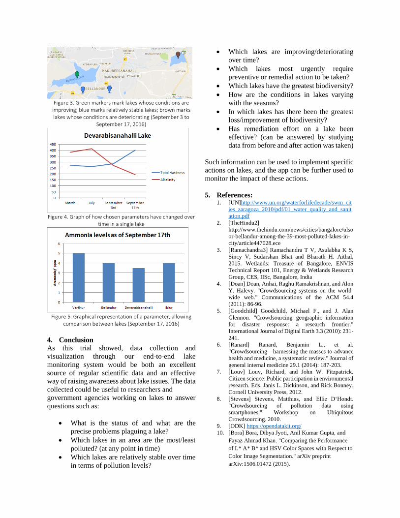
Figure 3. Green markers mark lakes whose conditions are
improving; blue marks relatively stable lakes; brown marks lakes whose conditions are deteriorating (September 3 to
September 17, 2016)
Figure 4. Graph of how chosen parameters have changed over
time in a single lake
Figure 5. Graphical representation of a parameter, allowing
comparison between lakes (September 17, 2016)
4. Conclusion
As this trial showed, data collection and
visualization through our end-to-end lake
monitoring system would be both an excellent
source of regular scientific data and an effective
way of raising awareness about lake issues. The data
collected could be useful to researchers and
government agencies working on lakes to answer
questions such as:
What is the status of and what are the
precise problems plaguing a lake?
Which lakes in an area are the most/least
polluted? (at any point in time)
Which lakes are relatively stable over time
in terms of pollution levels?
Which lakes are improving/deteriorating
over time?
Which lakes most urgently require
preventive or remedial action to be taken?
Which lakes have the greatest biodiversity?
How are the conditions in lakes varying
with the seasons?
In which lakes has there been the greatest
loss/improvement of biodiversity?
Has remediation effort on a lake been
effective? (can be answered by studying
data from before and after action was taken)
Such information can be used to implement specific
actions on lakes, and the app can be further used to
monitor the impact of these actions.
5. References: 1. [UN]http://www.un.org/waterforlifedecade/swm_cit
ies_zaragoza_2010/pdf/01_water_quality_and_sanit
ation.pdf
2. [TheHindu2]
http://www.thehindu.com/news/cities/bangalore/ulso
or-bellandur-among-the-39-most-polluted-lakes-in-
city/article447028.ece
3. [Ramachandra3] Ramachandra T V, Asulabha K S,
Sincy V, Sudarshan Bhat and Bharath H. Aithal,
2015. Wetlands: Treasure of Bangalore, ENVIS
Technical Report 101, Energy & Wetlands Research
Group, CES, IISc, Bangalore, India
4. [Doan] Doan, Anhai, Raghu Ramakrishnan, and Alon
Y. Halevy. "Crowdsourcing systems on the world-
wide web." Communications of the ACM 54.4
(2011): 86-96.
5. [Goodchild] Goodchild, Michael F., and J. Alan
Glennon. "Crowdsourcing geographic information
for disaster response: a research frontier."
International Journal of Digital Earth 3.3 (2010): 231-
241.
6. [Ranard] Ranard, Benjamin L., et al.
"Crowdsourcing—harnessing the masses to advance
health and medicine, a systematic review." Journal of
general internal medicine 29.1 (2014): 187-203.
7. [Louv] Louv, Richard, and John W. Fitzpatrick.
Citizen science: Public participation in environmental
research. Eds. Janis L. Dickinson, and Rick Bonney.
Cornell University Press, 2012.
8. [Stevens] Stevens, Matthias, and Ellie D‘Hondt.
"Crowdsourcing of pollution data using
smartphones." Workshop on Ubiquitous
Crowdsourcing. 2010.
9. [ODK] https://opendatakit.org/
10. [Bora] Bora, Dibya Jyoti, Anil Kumar Gupta, and
Fayaz Ahmad Khan. "Comparing the Performance
of L* A* B* and HSV Color Spaces with Respect to
Color Image Segmentation." arXiv preprint
arXiv:1506.01472 (2015).

The Problem and Solution ApproachSee the video at:
https://www.youtube.com/watch?v=x6Q0K0lIjWE

Results from Devarabisanahalli Lake Water Testing
2

System Architecture Overview
3
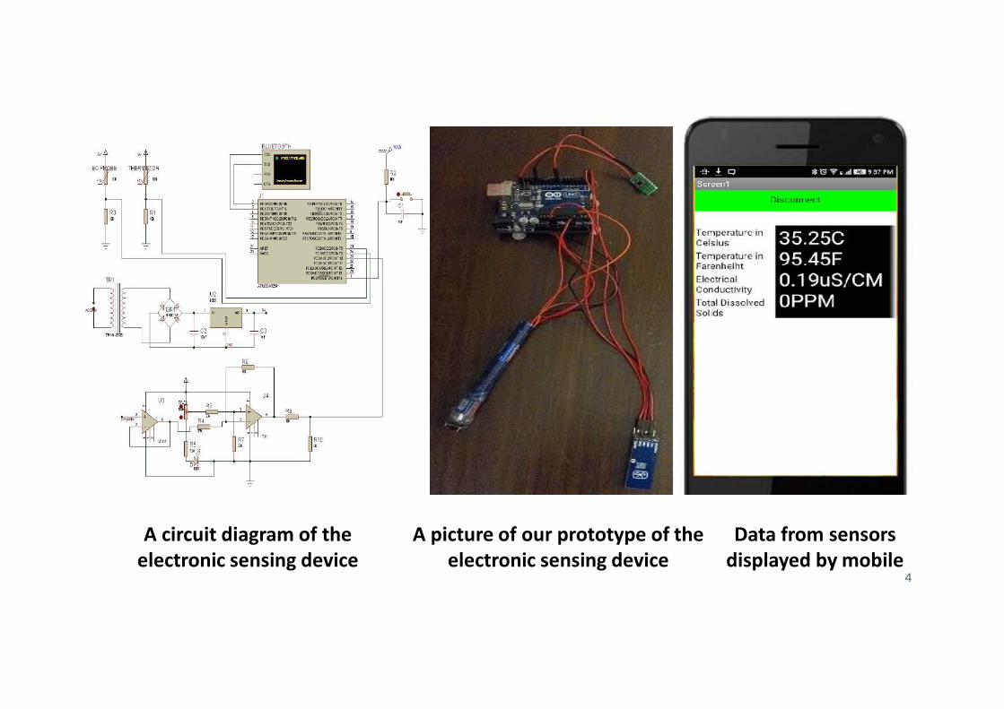
A circuit diagram of the electronic sensing device
A picture of our prototype of the electronic sensing device
Data from sensors displayed by mobile
4

Calibration procedure for the color recognition module
5

Test strip color capture
6

Screenshots of some screens the user may go through while using the mobile application
7

Sample cloud visualizations from real crowdsourced data
8

9
Top Related