


Languages
Pages
Legal

City of Hamilton
Ward Boundary Review
Final Report
In association with:
Dr. Robert J. Williams
October 11, 2016

Watson & Associates Economists Ltd. H:\Hamilton\Ward Boundary Review\Report\Final Report\Hamilton WBR Final Report.docx
Contents
Page
1. Study Overview .................................................................................................... 1 1.1 Terms of Reference ................................................................................... 1 1.2 Context ...................................................................................................... 1 1.3 Study Objectives ........................................................................................ 3 1.4 Project Structure and Timeline ................................................................... 4
1.5 The Interim Report ..................................................................................... 5 1.6 Public Consultation .................................................................................... 6
2. Guiding Principles for Hamilton’s Ward Boundary Review ................................... 8
2.1 Overview of Guiding Principles .................................................................. 8 2.2 Relative Weighting of Guiding Principles ................................................... 8
3. Hamilton – A Changing City with Implications for Ward Boundary Design ......... 10
3.1 Origins of a Diverse City .......................................................................... 10 3.2 Population Growth Trends and Population Balance by Ward .................. 13 3.3 Hamilton’s Attributes and Considerations for Optimal Ward Design ........ 18
4. Assessment of the Existing Ward Structure and Preliminary Options ................ 20 4.1 Hamilton’s Existing Ward Structure ......................................................... 20
4.2 Preliminary Ward Boundary Options ........................................................ 22
5. Final Options ...................................................................................................... 26 5.1 15-Ward Option ....................................................................................... 27
5.2 16-Ward Option ....................................................................................... 31
6. Recommendations .............................................................................................. 36
Appendix A – Public Consultation ................................................................................A-1
Appendix B – 15-Ward Option Proposed Ward Boundaries .........................................B-1
Appendix C – 16-Ward Option Proposed Ward Boundaries ........................................ C-1

Page 1
Watson & Associates Economists Ltd. H:\Hamilton\Ward Boundary Review\Report\Final Report\Hamilton WBR Final Report.docx
1. Study Overview
1.1 Terms of Reference
Watson & Associates Economists Ltd., in association with Robert J. Williams, Trust
Learning Solutions and ICA Associates Inc., were retained to undertake a
comprehensive Ward Boundary Review (W.B.R.) for the City of Hamilton. The
Consultant Team has operated independently from Council and City staff and have
conferred with residents and stakeholders to evaluate the existing ward structure, and
design possible alternative ward boundary configurations. The final phase of the study
provides Council with a final report and alternative ward boundary structures for their
consideration, as presented herein.
1.2 Context
The basic requirement for any electoral system in a representative democracy is to
establish measures to determine the people who will constitute the governmental body
that makes decisions on behalf of electors. Representation in Canada is organized
around geographic areas, units referred to as constituencies in the federal and
provincial parliaments and typically as wards at the municipal level, as is the case in the
City of Hamilton. At present, Hamilton’s City Council consists of fifteen Councillors
elected in fifteen wards (one Councillor per ward) and a Mayor elected at-large.
A ward boundary review is a task designed to develop such units of representation that
reflect the distribution of the inhabitants of a municipality for electoral purposes. Since
municipalities experience demographic shifts as a result of new residential
development, intensification and changes in the composition of their population,
electoral arrangements need to be reviewed periodically to ensure that representation
remains fair and that electors have an opportunity to elect candidates they feel can truly
represent them and their neighbours.
Hamilton’s existing ward boundary structure, as presented in Figure 1, dates from
amalgamation in 2001 – 15 years ago. Since that time, the City has seen notable
population growth and shifts and changes in its composition and structure, suggesting
that now is an appropriate time to undertake a review of this nature.
The 2015-2016 W.B.R. represents the first opportunity that the local electoral needs of
all the residents of the amalgamated City are being considered collectively through the
same terms of reference and guiding principles offering a genuine “Made in Hamilton”

Page 2
Watson & Associates Economists Ltd. H:\Hamilton\Ward Boundary Review\Report\Final Report\Hamilton WBR Final Report.docx
review. As discussed in the Interim Report, the current ward structure for the City of
Hamilton was assembled from its component parts without the benefit of a
comprehensive local review and without formal local approval.
Prior to amalgamation in 2001, each of the former six municipalities1 that now comprise
the City of Hamilton made their own decisions about how to represent its residents in
the election of their respective local Councils without regard for the broader context.
For example:
One municipality elected its council at-large (the Town of Dundas); all other
councils were elected in wards.
The Town of Ancaster was moving “to improve the distribution of electors” in its
five wards in 1996. Steps were being taken to develop options that consolidated
most of the rural vote “so that rural electors predominate in at least one ward.”
In at least one case, deciding ward boundaries was a contentious process. The
City of Stoney Creek was engaged in a redivision of its seven wards in 1996 that
was (a) being appealed to the Ontario Municipal Board, and (b) then terminated
when a decision was taken in relation to dissolving Hamilton-Wentworth Region
and replacing it with the new City of Hamilton.
In pre-amalgamation Hamilton, the system of representation had gone through
changes at the end of 1980 related to the elimination of the Board of Control and
a change to the composition of Council (16 members in 8 wards sitting on both
councils). Hamilton had revised its ward boundaries in 1971 and again in 1985;
in both designs, there were five wards in the lower City and three on the
Mountain.
Given the diversity of the amalgamated City, it will require some vision and new
perspectives to achieve an equitable, effective and accurate result. The W.B.R. is
premised on the legitimate democratic expectation that municipal representation in
Hamilton will be effective, equitable and an accurate reflection of the contemporary
distribution of communities and people across the City.
1 On January 1, 2001, the new City of Hamilton was formed through the amalgamation of the former city and five other lower-tier municipalities including the City of Stoney Creek, the Towns of Ancaster, Flamborough and Dundas and the Township of Glanbrook.

Page 3
Watson & Associates Economists Ltd. H:\Hamilton\Ward Boundary Review\Report\Final Report\Hamilton WBR Final Report.docx
Figure 1: City of Hamilton Wards
1.3 Study Objectives
The primary purpose of the W.B.R. is to prepare Hamilton City Council to make a
decision about whether to maintain the existing ward structure or to adopt an alternative
arrangement.1 The project has a number of key objectives in accordance with the
project terms of reference, as follows:
Develop a clear understanding of the present ward system, including its origins
and operations as a system of representation;
Evaluate the strengths and weaknesses of the present ward system on the basis
of the identified guiding principles;
Conduct an appropriate consultation process to ensure community support for
the review and its outcome;
Identify plausible modifications to the present ward structure; and
1 Municipal councils have the legal right to create, change and even eliminate ward boundaries for the purpose of electing municipal councillors as per the Municipal Act (sections 222 and 223).

Page 4
Watson & Associates Economists Ltd. H:\Hamilton\Ward Boundary Review\Report\Final Report\Hamilton WBR Final Report.docx
Deliver a report that will set out recommended alternative ward boundaries to
ensure effective and equitable electoral arrangements for the City of Hamilton,
based on the principles identified.
1.4 Project Structure and Timeline
The W.B.R. commenced in October, 2015 and is anticipated to be completed in
October, 2016.
The study encompasses four main phases, of which Phases 1 through 3 have been
completed:
Phase 1 – Review background data and technical analysis, develop public engagement
strategy and initiate the consultation process with City staff and elected officials to
gather insights into the present ward system;
Phase 2 – Hold public information and engagement sessions concentrating on the
existing ward structure and guiding principles (Round 1 Consultation);
Phase 3 – Prepare an interim report on preliminary options and hold public
consultations on preliminary options (Round 2 Consultation); and
Phase 4 – Finalize alternatives and prepare a final report with recommendations for
Council.
The study is currently in Phase 4 and this document constitutes the Final Report.
Work completed through Phases 1 through 4 has included:
Research and data compilation;
Development and implementation of a Public Engagement Strategy;
Interviews with Councillors, the Mayor and municipal staff;
Consultation with representatives of school boards;
Population and growth forecasting and data modelling to 2026;
Round 1 of Public Consultation;
Preparation of a Progress Report which was presented to the City of Hamilton
General Issues Committee (G.I.C.) on June 1, 2016;
Development of eight preliminary ward boundary alternatives;
Preparation of an Interim Report, released to the public on June 9, 2016;
Round 2 of Public Consultation;

Page 5
Watson & Associates Economists Ltd. H:\Hamilton\Ward Boundary Review\Report\Final Report\Hamilton WBR Final Report.docx
Development of final options and recommendations, and preparation of Final
Report; and
In collaboration with Communications staff at the City:
o A project web page was set up – see http://hamilton.ca/wardboundaryreview,
along with a dedicated project email address;
o A video of the research findings and context of the review was recorded
and posted on the website;
o Study reports, maps and findings were posted on the City website;
o Social media comments were tracked; and
o Local media was invited to attend and report.
1.5 The Interim Report
An Interim Report was released to the Hamilton community on June 9, 2016, just ahead
of the second round of Public Consultations (Phase 3 of the study). That report serves
as a platform for the Final Report since it includes:
An explanation of the Terms of Reference and Objectives for the W.B.R.;
An outline of the format and timeline for the project, as well as an explanation of
the purpose and strategies followed in the public consultation component and a
summary of the findings of Round 1 of consultation;
The context for the 2015-2016 Hamilton W.B.R., including the rationale for
utilizing population and not electors to assess parity, and the consideration of
post-secondary students in the City’s total population;
A detailed discussion and explanation of the six Guiding Principles that frame the
study;
An analysis of the distribution of the present (2015) City population and a
forecast of population growth over the 2015-2026 period;
An analysis and evaluation of the present Wards within the context of the six
Guiding Principles; and
Preliminary Alternative Ward Options developed by the Consultant Team around
four models of representation.
The Final Report, as presented herein, does not explore these topics in detail except in
summary form to provide context and assumes that those interested in the
recommendations included herein have reviewed the Interim Report.

Page 6
Watson & Associates Economists Ltd. H:\Hamilton\Ward Boundary Review\Report\Final Report\Hamilton WBR Final Report.docx
1.6 Public Consultation
The Hamilton W.B.R. incorporated a comprehensive public engagement component
which included two distinct phases of public consultation – Round 1 and Round 2.
Details on the public engagement component are presented in the Public Engagement
Plan which is provided in Appendix A.
The purpose of the public engagement component was twofold:
To engage the people of Hamilton in a manner that provides valuable input to the
evaluation of the existing ward structure and development of alternative ward
boundaries; and
To ensure Council that ward boundary alternatives reflect municipal vision,
principles of the Public Engagement Charter and community input.
The outcomes of the public engagement component include the following:
Citizens learned about the reason for the W.B.R. and the key factors that were
considered in the review;
Citizens provided useful input to the Consultant Team in the evaluation of the
existing system and in developing design alternatives; and
Citizens were given a sense that their input might genuinely influence the review.
Public Consultations in Round 1 and Round 2 are discussed in detail below.
Round 1
In Round 1 of consultation, conducted in February 2016, the views of residents were
sought on the continued suitability of the present ward structure and on the guiding
principles. Through the public consultation meetings and through the project website
online comment/feedback form, participants were invited to provide their input/opinions
with regard to the following:
What are some of the strengths and weaknesses of the current ward system?
and
What do the given “principles” mean to you and which principles should be given
the highest priority in the evaluation of the existing ward structure and
development of ward boundary options?
The feedback and comments received from Round 1 of consultation were reflected in
the analysis included in the Interim Report released to the community in June 2016.

Page 7
Watson & Associates Economists Ltd. H:\Hamilton\Ward Boundary Review\Report\Final Report\Hamilton WBR Final Report.docx
Round 2
The second round of public consultations was completed in Phase 3 of the study during
the period June 9 to June 29, 2016. Through the public consultation meetings in Round
2 and the project web page, the public was provided with information and context with
respect to the evaluation of the existing ward structure and was presented eight
preliminary ward boundary alternatives based on four distinct models of representation.
In Round 2 of consultation, residents were asked to evaluate the preliminary alternative
ward models for Hamilton through a series of public outreach initiatives:
Nine public consultation meetings held throughout Hamilton where the
preliminary alternatives were presented, along with the issues being addressed
in each option, through a series of display boards and a PowerPoint
presentation. Attendees were asked to comment on the preliminary options
through a “Passport” comment form;
Project materials, including all project display boards, a PowerPoint presentation
and the Interim Report, were made available through the project website;
Online comment/feedback form provided through the project web page; and
Dedicated email address for general comments/input from the public.
Round 2 of consultation achieved a moderate level of public engagement, as follows:
Approximately 90 people attended the public meetings;
105 online submissions were received using the feedback/comment form; and
Numerous emails from the public were received.
The feedback and comments received from Rounds 1 and 2 of consultation are
reflected in the analysis presented herein and have helped inform the findings and
recommendations.
Feedback received through both rounds of public consultations is summarized in
Appendix A.

Page 8
Watson & Associates Economists Ltd. H:\Hamilton\Ward Boundary Review\Report\Final Report\Hamilton WBR Final Report.docx
2. Guiding Principles for Hamilton’s Ward Boundary Review
2.1 Overview of Guiding Principles
Hamilton’s W.B.R. is framed by six guiding principles (presented to the General Issues
Committee (G.I.C.) – Clerk’s Report CM15004, March 30, 2015) established for
evaluating the existing ward boundary structure and potential alternative options. The
principles are guidelines and do not preclude additional contributing factors being
considered. The six principles (discussed in more detail in Chapter 3 of the Interim
Report) are:
Representation by Population – Ensure that every Councillor generally
represents an equal number of constituents while allowing for some variation;
Population and Electoral Trends – Look at future changes in population to
keep wards as balanced as possible;
Means of Communication and Accessibility – Group neighbourhoods into
wards that reflect current transportation and communication patterns;
Geographical and Topographical Features – Use natural features as ward
boundaries while keeping wards as compact as possible;
Community or Diversity of Interests – Draw ward boundary lines around
recognized settlement areas, traditional neighbourhoods, and community
groupings; and
Effective Representation – Evaluate the capacity of each ward to give residents
an effective voice in decision-making.
2.2 Relative Weighting of Guiding Principles
No ward system design can uniformly meet all of the guiding principles since some
criteria may work at cross-purposes to one another. As well, the priority attached to
certain principles makes some designs more desirable in the eyes of different
observers.
The public consultation activities during Phase 1 of this Review (Round 1 of public
consultation) were designed to better understand the priorities attached to the six
principles among Hamilton residents. As part of the consultation process, residents
were asked: “What principles should be given the highest priority in redesigning the
ward system in Hamilton?”

Page 9
Watson & Associates Economists Ltd. H:\Hamilton\Ward Boundary Review\Report\Final Report\Hamilton WBR Final Report.docx
While it is important to consider all the guiding principles in the evaluation process,
based on feedback received from the public, the highest priority principles seem to be
Effective Representation, Representation by Population, and Communities of Interest,
as illustrated in Figure 2.
Figure 2: Relative Priority of Guiding Principles Based on Public Feedback
Those who participated in Round 2 of public consultation of this review were requested
to rank their preferred Preliminary Options in light of the guiding principles. The
preferences identified were highly influenced by a desire for options that satisfied the
goals of representation by population, effective representation and preserving
communities of interest.
Ultimately, the ward design adopted by Hamilton Council should be the one that best
fulfills as many of the six guiding principles as possible, but it should have regard for the
input received from the public through the consultation process.
Effective Representation
25%
Representation by Population
22%
Communities of Interest
20%
Geographic And Topo Features
16%
Population and Electoral Trends
11%
Communication and accessibility
6%
What principles should be given the highest priority in redesigning the ward system in
Hamilton?
Source:Based on aggregated responses from online submissions and public workshopsthrough Hamilton Ward Boundary Review Round 1 of public consultation.

Page 10
Watson & Associates Economists Ltd. H:\Hamilton\Ward Boundary Review\Report\Final Report\Hamilton WBR Final Report.docx
3. Hamilton – A Changing City with Implications for Ward Boundary Design
3.1 Origins of a Diverse City
As previously discussed, the City of Hamilton was created through provincial legislation
that took effect January 1, 2001. The present-day City is an amalgamation of six
existing lower-tier municipalities (Ancaster, Dundas, Glanbrook, Flamborough, Hamilton
and Stoney Creek) and the Regional Municipality of Hamilton-Wentworth, an entity itself
created in the 1970s that embraced both the City of Hamilton and municipalities in the
surrounding Wentworth County, some of which were also amalgamated at that time.
Through Provincial Regulation 448/00, a City Council consisting of a Mayor and 15
Councillors was established. The ward structure implemented maintained the eight
existing wards in the old City of Hamilton.1 Four wards utilized the boundaries of other
pre-amalgamation municipalities and three wards were created in Ancaster and
Flamborough, one of which relied largely on Highway 403 as a ward boundary west of
Shaver Road rather than the historical municipal boundary along Governor’s Road west
of Middletown Road.
With a land area of 1,138 km² and a population of approximately 565,000,2 Hamilton is
one of Ontario’s largest municipalities with respect to population and geographic area.
Due to its large geographic size and origins through an amalgamation, Hamilton is a
highly diverse City comprised of numerous urban, suburban and rural communities with
varying population densities. This includes a number of distinct communities with
unique origins and historical settlement patterns including downtown Hamilton and the
upper city, Stoney Creek, Winona, Binbrook, Mount Hope, Ancaster, Dundas and
Waterdown. The varied structure of the City is complicated by the Niagara Escarpment
which dissects the City and has influenced its settlement patterns.
Like virtually every contemporary city, patterns of settlement and density reflect
demographic and socio-economic variations that relate to family size and structure,
occupation and income, commuting patterns and dwelling characteristics (e.g. age and
type). The urban centre of Hamilton is built upon its long and well-earned status as an
1 The boundaries used for Wards 1 through 8 were first been used in the 1985 municipal election and have not been revised since. 2 Watson & Associates Economists Ltd. estimate for 2015; includes Census undercount and non-permanent post-secondary student population.

Page 11
Watson & Associates Economists Ltd. H:\Hamilton\Ward Boundary Review\Report\Final Report\Hamilton WBR Final Report.docx
industrial centre with an associated high population density and distinctive residential
pattern that clustered around the historic employment lands, a large portion of which are
located along the City’s waterfront.
The earliest settlement in what is now central Hamilton (the lower City) follows a formal
grid pattern from the waterfront, south towards the base of the escarpment. That area
was largely developed by the end of the nineteenth century. By the early twentieth
century, widespread residential development began on the Mountain and, over the
decades, stretched southward in a similar pattern. Before the time of regional
government and the creation of the Regional Municipality of Hamilton-Wentworth in
1974, the geographic area of the current City of Hamilton contained vast areas of rural
lands and an urban base comprised of the former City of Hamilton with relatively
compact settlement areas in the surrounding municipalities, . At the time, Hamilton’s
distinct communities were more geographically separated by extensive rural areas than
today, as illustrated in Figure 3. Over the past decades, suburban greenfield
development has filled in most of the rural areas that once separated the various distinct
communities that comprise the City, creating one large contiguous urban area, with the
exception of Waterdown and Binbrook, which are still individual urban nodes. This has
been most apparent in the west Mountain area in Ancaster and in Stoney Creek (upper
and lower) which are now part of a contiguous urban area with the rest of Hamilton.
With future growth, this expansion of the urban area into the periphery of the City is
expected to continue.

Page 12
Watson & Associates Economists Ltd. H:\Hamilton\Ward Boundary Review\Report\Final Report\Hamilton WBR Final Report.docx
Figure 3: City of Hamilton Urban Development Trends, 1971 to Present
As Hamilton has grown and evolved, the former municipal boundaries that formed the
pre-amalgamated City have begun to blur in the manner in which residents engage or
associate with their broader community. For example, school attendance boundaries,
Canada Post Forward Sortation Areas (FSAs) and retail trade areas, often cross these
previous municipal boundaries. With the possible exception of the urban nodes in
Waterdown and Binbrook, the urban population clusters in Hamilton today are inter-
connected and not isolated from one another – nor are they free-standing communities.
It is important to recognize that municipalities are in a constant state of change, with
respect to population growth and shifts, as well as demographic and socio-economic
changes which influence the character of the neighbourhoods and communities within
them. While it is recognized that Hamilton is still a City of communities that once
defined the various pre-amalgamated municipalities, the pre-amalgamation municipal
boundaries no longer represent the definitive boundaries of these communities.
Conversely, the present system of representation appears to be built on
compartmentalization: some wards are in “the City” and the others are “in the suburbs.”
That is, the model of representation established in 1999-2000 was built on the basis of
what were perceived to be a hard set of lines that perpetuated the boundaries of the

Page 13
Watson & Associates Economists Ltd. H:\Hamilton\Ward Boundary Review\Report\Final Report\Hamilton WBR Final Report.docx
pre-existing municipalities, some of which were established in the nineteenth century
and others that were devised only in the 1970s when the Regional Municipality of
Hamilton-Wentworth was created. Beverly Township (dating from 1816) and Saltfleet
Township (dating from the 1780s), for example, were both absorbed by neighbouring
municipalities at that time. The wards established in 1999-2000 kept the pre-
amalgamation borders that amalgamation was intended to overcome or at least blur.
3.2 Population Growth Trends and Population Balance by Ward
Since amalgamation, Hamilton’s permanent population has increased by 7%, from
510,000 in 2001 to an estimated 548,000 in 2015.1 Over this period, the City has also
experienced moderate growth in a non-permanent post-secondary student population.
Population growth over the past two decades has been concentrated in suburban
communities including Waterdown, Stoney Creek, Binbrook, Upper Mountain and
Ancaster.
As of 2015, the City has an estimated total population of 565,000, including both
permanent and non-permanent post-secondary student population.2 The City is
expected to experience relatively strong population growth over the next decade, with
the population expected to expand by approximately 68,000 over the 2015-2026 period,
an increase of 12%. Population growth is expected to be concentrated in Stoney Creek,
the Upper Mountain area, Binbrook and Waterdown through greenfield development.
Over the period, the City is expected to also see a moderate amount of residential
intensification, largely within the urban core and along the King Street corridor within the
lower City
Since 2001, population growth has varied widely by ward, with strongest rates of growth
occurring in the suburban wards, including Wards 11, 12, 9, and 15, as presented in
Figure 4. Wards 7 and 8 also saw moderate population growth over the period, while a
number of the lower city wards experienced population declines during the period.
Over the 2015-2026 forecast period, population growth by ward is expected to continue
to vary widely, as shown in Figure 4. The highest population growth is expected in
Ward 11, followed by Wards 9, 15, 12, 2 and 1. Wards 5, 7 and 8 are expected to see
1 2001 population derived from Statistics Canada Census. 2015 population an estimate by Watson & Associates Economists Ltd. Permanent population includes Census undercount but excludes non-permanent post-secondary student population. 2 Watson & Associates Economists Ltd. estimate; includes Census undercount of approximately 4%.

Page 14
Watson & Associates Economists Ltd. H:\Hamilton\Ward Boundary Review\Report\Final Report\Hamilton WBR Final Report.docx
minimal population growth, while Wards 3, 10, 14, 4, 13 and 6 are expected to see
marginal population declines over the period.
Figure 4: City of Hamilton Population Growth by Ward, 2001-2015 and 2015-2026
Since the City is comprised of varying types of residential clusters, its population and
growth trends are not dispersed uniformly across its geographic area. The population
distribution reflected in the present wards demonstrates this. Since 2001, the City has
experienced growth that has increased the disparity in the population of the wards to a
significant extent – the widest variation is between Wards 7 and 14, where the
population of the former is more than 3½ times larger than that of the latter
(approximately 62,000 vs. 17,000). As presented in Figure 5, several wards in the old
City of Hamilton, including Wards 7 and 8, are well above the optimal population for a
typical ward in Hamilton and others, including Wards 10, 13 and 14, are well below the
optimal population for a typical ward in Hamilton.1 The imbalance in population by ward
is expected to worsen over time, with Ward 11 expected to have a population well
above the optimal range by 2026.
1 Population variations of up to 25% above or below the optimal (average) size will be
considered generally acceptable, a range consistent with legislated federal redistribution
provisions. The optimal (average) population size per ward in Hamilton in 2015 and
2026 is 37,685 and 42,190, respectively.
-20%
0%
20%
40%
60%
80%
100%
120%
1 2 3 4 5 6 7 8 9 10 11 12 13 14 15
Ward
2001-2015 2015-2026
Source: Watson & Associates Economists Ltd.

Page 15
Watson & Associates Economists Ltd. H:\Hamilton\Ward Boundary Review\Report\Final Report\Hamilton WBR Final Report.docx
Figure 5: City of Hamilton Population Variance by Ward 2001, 2015 and 2026
Over the 2001-2015 period, a number of major structural changes have begun to take
shape in Hamilton which are expected to continue over the next decade. These trends
have, and are expected to, perpetuate the population imbalances that exist by ward.
These include:
Former City of Hamilton vs. Suburb Population Balance
At the time of amalgamation in 2001, the former City of Hamilton, represented by Wards
1 through 8, accounted for about two-thirds of the City’s population base, with the
remaining one-third comprised of suburban and rural population within the former
municipalities of Stoney Creek, Glanbrook, Ancaster, Dundas and Flamborough, as
shown in Figure 6. Due to rapid population growth in suburban areas over the past 15
years compared to limited growth in the urban core, the former City of Hamilton’s share
of total population declined to 62% by 2015. Despite expected residential intensification
and moderate population growth over the coming decade within the urban core, the
decline in population share is expected to continue, with the former City of Hamilton
expected to account for 56% of total population by 2026. Over the 2015-2026 period,
only about 10% of population growth is expected to occur within the former City of
Hamilton compared to 90% within other areas.
0
0.25
0.5
0.75
1
1.25
1.5
1.75
2
0 1 2 3 4 5 6 7 8 9 10 11 12 13 14 15
Popula
tion V
ariance
Ward
2001 2015 2026
Below Range
Above RangeWards
7&8
Ward 10 Ward 13
Ward 14
Ward 11(2026)
Within Desired Range of Variation
Source: Watson & Associates Economists Ltd.

Page 16
Watson & Associates Economists Ltd. H:\Hamilton\Ward Boundary Review\Report\Final Report\Hamilton WBR Final Report.docx
Figure 6: City of Hamilton Population Share – Former City vs. Other Areas, 2001-2026
Urban vs. Rural Population Growth Trends
While Hamilton has a diverse urban and rural population base, over the past 15 years
the City’s urban population has expanded significantly while the City’s rural population
has declined. This has resulted in a shift in the City’s population base from rural to
increasingly urban. In 2001, 91% of the City’s population was urban while 9% was
rural, as illustrated in Figure 7. By 2015, the City’s urban share had increased to 92%.
Over the next decade, Hamilton’s population is expected to continue to shift increasingly
to a more urban character. By 2026, the City’s urban population is expected to account
for 93% of the total population base.
67% 62% 56%
33% 38% 44%
0%
20%
40%
60%
80%
100%
2001 2015 2026
Sha
re o
f P
op
ula
tio
n
Year
Former City Hamilton Other Areas
Source: 2001 population derived from Statistics Canada Census data. 2015 and 2026population data estimate and forecast, respectively by Watson & Associates Economists Ltd.Population data excludes non-permanent post-secondary s tudent population.

Page 17
Watson & Associates Economists Ltd. H:\Hamilton\Ward Boundary Review\Report\Final Report\Hamilton WBR Final Report.docx
Figure 7: City of Hamilton Population Share – Urban vs. Rural, 2001-2026
West vs. East Population Balance
Geographically, the City of Hamilton can be divided east-west by Highway 403, which
dissects the City approximately in the centre. The area to the east of Highway 403 has
historically contained the majority of the City’s population base. At the time of
amalgamation in 2001, approximately 80% of the City’s population resided east of
Highway 403, while 20% were located west of the highway.
Over the past 15 years, population growth has also been concentrated east of Highway
403 and the population base continues to shift gradually to the east. Over the 2001-
2015 period, 88% of the City’s population growth was accommodated east of Highway
403, as shown in Figure 8. This trend is expected to continue, with 86% of population
growth over the 2015-2026 period expected to be accommodated east of Highway 403,
as illustrated in Figure 8.
90.8% 92.3% 93.3%
9.2% 7.7% 6.7%
0%
20%
40%
60%
80%
100%
2001 2015 2026
Sha
re o
f P
op
ula
tio
n
Year
Urban Rural
Source: 2001 population derived from Statistics Canada Census data. 2015 and 2026
population data estimate and forecast, respectively by Watson & Associates Economists Ltd.Population data excludes non-permanent post-secondary s tudent population.

Page 18
Watson & Associates Economists Ltd. H:\Hamilton\Ward Boundary Review\Report\Final Report\Hamilton WBR Final Report.docx
Figure 8: City of Hamilton Population Growth Trends – East and West of Highway 403
3.3 Hamilton’s Attributes and Considerations for Optimal Ward
Design
The analysis in section 3.2, discussing Hamilton’s diverse nature, origins and population
growth trends, raises a number of opportunities and challenges with respect to ward
boundary design. Key themes are discussed below.
Achieving Population Parity by Ward within a Municipality without Population Uniformity
The guiding principles are clear: in an ideal scenario, the population of all wards would
be close to parity (the actual principle is stated as: “Ensure that every Councillor
generally represents an equal number of constituents while allowing for some
variation”). In fact, two of the present wards far exceed the optimal size and three are
smaller than optimal. Theoretically, a ward redivision would be directed towards trying
to bring the larger wards down to the optimal range and the smaller wards up to the
optimal threshold.
Pursuing such a strategy has spatial implications for the entire ward design in the sense
that the overall distribution of population in Hamilton is concentrated in the central and
eastern parts of the City and growth is shifting further south and east. The western
areas of the City (including the communities of Dundas, Ancaster and Flamborough),
12% 14%
88% 86%
0%
20%
40%
60%
80%
100%
2001-2015 2015-2026
Sha
re o
f P
op
ula
tio
n G
row
th
Period
West of Highway 403 East of Highway 403
Source: 2001 population derived from Statistics Canada Census data. 2015 and 2026
population data estimate and forecast, respectively by Watson & Associates Economists Ltd.Population data excludes non-permanent post-secondary s tudent population.

Page 19
Watson & Associates Economists Ltd. H:\Hamilton\Ward Boundary Review\Report\Final Report\Hamilton WBR Final Report.docx
conversely, are relatively lightly populated and have lower growth prospects than areas
to the east over the next decade. Major growth nodes (with the exception of
Waterdown) are located to the south and east of the present built up area. In other
words, a redivision that adheres strictly to population parity will skew the ward
configuration away from the western side of the City.
Urban-Rural Divide and the Rural Area as a Distinct Precinct
As noted earlier, the stereotypical image of Hamilton is urban. In the immediate pre-
amalgamation decades, the idea that there was still a rural (or agricultural) Hamilton
would have been implausible since the City had virtually no areas of active agriculture.
Amalgamation changed that condition dramatically since, today, approximately 79% of
the present City’s land area is classified as agricultural/rural (i.e. outside the urban
boundary).1
In terms of representation, the ward profiles posted on the City website designate one
ward as “rural,” three as “primarily rural,” three as “urban and rural,” one as “primarily
urban” and eight as “urban.” It is apparent that there is significant rural territory within
present-day Hamilton and it surrounds the urban area on three sides. Rural and
agricultural economic activity is important in seven of the wards. Rural Hamilton,
however, is also diverse in the sense that it includes a variety of forms of agriculture, as
well as numerous conservation areas, parks and open spaces. Most of the rural
territory on the west side of the City is expected to remain in rural form indefinitely, but
rural areas to the south and east are transitioning into new suburban communities. In
the public consultation sessions, the value of this rural community of interest was
asserted consistently.
Rural Hamilton is, however, sparsely populated which makes the application of
population parity a challenge. In this context, it is imperative to take account of an
important decision made by the Ontario Municipal Board in relation to an attempt to
design ward boundaries in another Ontario municipality where a rural perimeter was
added to an urban core; this is the case of the appeal of Osgoode Rural Communities
Association, et al against the City of Ottawa (2003).
In that case, a City of Ottawa ward boundary by-law was based on recommendations
from a Task Force appointed by the City Council that merged rural communities with
suburban communities. It was rejected by the Board on the grounds that the City “did
not properly take into consideration the concerns of the rural community and the
1 Based on share of City’s land area located outside of current urban boundary.

Page 20
Watson & Associates Economists Ltd. H:\Hamilton\Ward Boundary Review\Report\Final Report\Hamilton WBR Final Report.docx
protection of the communities of interest that exist within that segment of the City.” In
addition, the Board found that it was unacceptable for the Task Force to simply see the
rural areas as “extensions” of the suburban communities and to recommend “the
combination of the rural population with the fringe suburban population for the purpose
of achieving higher populations in certain wards.” Furthermore, the adoption of the
“concept that rural areas no longer enjoyed a distinct character became a convenient
rationale to ignore any obligation to preserve rural communities of interest. The
evidence [heard by the Board] supports the contention that the City of Ottawa does
contain rural communities with historical economic and social differences.”
In the Hamilton W.B.R., it is acknowledged and understood that Hamilton’s rural area
has “a distinct character” that must be protected. In this respect (as was the case in
Ottawa), the Carter principles assume significance.1 In a large diverse municipality,
strict application of population principles can lead to untenable wards. The Board has
made it clear that such designs are unacceptable when they ignore a clear community
of interest.
4. Assessment of the Existing Ward Structure and Preliminary Options
The Interim Report presented a detailed evaluation of the existing ward boundary
structure, and presented eight preliminary ward boundary options based on four models
of representation which were taken to the public for input and comment. Based on the
responses received, the Consultant Team was able to draw some conclusions about
their suitability as candidates for finalized options, and the public responses helped
inform subsequent recommendations. The following section provides a summary of the
existing ward structure evaluation and a summary of the preliminary options, along with
the public input received on them.
4.1 Hamilton’s Existing Ward Structure
A detailed evaluation of the existing ward structure in Hamilton is found in section 5 of
the Interim Report. That discussion rigorously applies the six guiding principles to the
individual wards and the overall design.
1 See the City of Hamilton Ward Boundary Review Interim Report pages 3-4 to 3-6 for an explanation of the Carter case and the principles that have been applied in the context of municipal representation.

Page 21
Watson & Associates Economists Ltd. H:\Hamilton\Ward Boundary Review\Report\Final Report\Hamilton WBR Final Report.docx
The evaluation suggested that the existing ward boundary configuration does not
successfully meet the expectations for any of the six guiding principles, as illustrated in
Figure 9. In addition, from the perspective of those who participated in the public
consultations, the existing ward boundary structure has some strengths, but the
weaknesses identified are significant and outweigh the identified strengths.
Based on public feedback from Rounds 1 and 2 of consultation, there is a strong desire
for change. There is a strong interest from the public in seeing the ward structure
changed to address identified shortcomings in the current system, while the support
from the few respondents who favoured retaining the current system was lukewarm (for
example, it is “acceptable”) or counterfactual (“population will balance over time as rural
wards expand”).
It would be improbable that a ward system review aiming to meet the principles set out
herein would recommend a structure using the existing ward boundaries and, therefore,
it is our conclusion that Council should move to change from the status quo.
Figure 9: Existing City of Hamilton Ward Boundary Configuration Evaluation Summary
Principle Does Existing Ward Structure
Meet Requirements of Principle?
Comment
Representation by Population No Two wards above acceptable range, three below range
Population and Electoral Trends
No Three wards above acceptable range, three below range
Means of Communication and Accessibility
Partially successful
Generally clear markers with minor deficiencies; limited access highways divide five wards
Geographical and Topographical Features
Largely successful
Two wards include neighbourhoods above and below Escarpment
Community or Diversity of Interests
Partially successful
Very few communities of interest are divided internally, some groupings questionable (Wards 5 and 11 especially)
Effective Representation No Significant dilution of representation (Wards 7 and 8), lack of coherence (Ward 11)

Page 22
Watson & Associates Economists Ltd. H:\Hamilton\Ward Boundary Review\Report\Final Report\Hamilton WBR Final Report.docx
4.2 Preliminary Ward Boundary Options
As presented in the Interim Report, four preliminary approaches to representation in
Hamilton were derived from the guiding principles, the initial public consultation
meetings (Round 1), and other insight derived from the Consultant Team’s experiences
in developing ward boundary systems in other Ontario municipalities. This included:
Option 1: Derivative of Federal Constituency Boundaries – based on the
recently established federal constituency boundaries;
Option 2: Preservation of the Pre-Amalgamation Balance – which works
within the “balance of representation” model found in the present ward system;
Option 3: Post-Amalgamation 15-Ward Model – places greater emphasis on
population parity with less regard for previous municipal boundaries; and
Option 4: Post-Amalgamation 16-Ward Model – similar to Option 3 except a
16-ward model.
As previously discussed, public input on the preliminary options was solicited through
Round 2 of public consultation via a survey “passport” circulated at the public open
houses and through an online survey form posted on the project web page. A key
question asked residents to rank their top three choices, selecting from the eight
preliminary options (Options 1, 2A, 2B, 3A, 3B, 4A, 4B, 4C) and the existing ward
structure (No Change). The aggregated responses from the public open houses and
the online survey, summarizing the top choice (1st choice), by the four option “themes”
is presented in Figure 10. As shown, Option 4 (16-ward post-amalgamation option)
was chosen as the top choice by 66% of respondents. This is compared to 14% for
Option 2 (15-ward pre-amalgamation option), 8% for Option 3 (15-ward post-
amalgamation option) and 5% for Option 1 (Derivative of Federal Constituency
Boundaries). Of the respondents, only 7% selected the current ward configuration (No
Change) as their top choice.

Page 23
Watson & Associates Economists Ltd. H:\Hamilton\Ward Boundary Review\Report\Final Report\Hamilton WBR Final Report.docx
Figure 10: Preliminary Options and Preference of Respondents based on 1st (Top) Choice
A recap of the Preliminary Options, along with a discussion of public reactions to the
Options, is provided below:
Preliminary Option 1 – Derivative of Federal Constituency Boundaries
Preliminary Option 1 was developed to create fifteen wards within the five federal
constituency boundaries in response to suggestions made during the first round of
public consultations. One feature was the apparent balance in population of the five
constituencies (i.e. federal ridings) that made the idea initially attractive. It was
acknowledged in the Interim Report, however, that the design actually had a number of
limitations, primarily with respect to the population metrics utilized to generate the five
federal constituencies, which resulted in notable population imbalances in practice: the
figures used were out of date (from the 2011 Census), there was no provision for
population growth and non-permanent post-secondary students were excluded from the
population count.
Public support for this Option ranked near the bottom and no meaningful defence for the
approach was provided in comments submitted to the Consultant Team. Given this
Option 15%
Option 214%
Option 38%
Option 466%
Current - No Change
7%
Source: Based on aggregated responses of Rank 1 choices of options from online submissionsand passport feedback from public open houses through Hamilton Ward Boundary Review Round 2 of public
consultation.

Page 24
Watson & Associates Economists Ltd. H:\Hamilton\Ward Boundary Review\Report\Final Report\Hamilton WBR Final Report.docx
assessment, the idea of drawing ward boundaries within the five federal constituencies
is not recommended.
Preliminary Option 2– Preservation of the Pre-Amalgamation Balance
The Interim Report included two preliminary Options that were developed with regard to
the guiding principles for this Review while still retaining the “representative balance”
between the old City of Hamilton (eight wards) and the other pre-amalgamation
municipalities (seven wards). See the Interim Report page 6-5.
The most striking observation is that the population distribution in the wards proposed in
these two Options continues to be inequitable in 2015 and 2026 and that includes the
distribution within both the wards in the “urban” subgroup (Wards 1 to 8) and the wards
in the “suburban” subgroup (Wards 9 to 15), which persists across the entire ward
structure. The positive attributes of the present system that are carried forward (but
related to the least valued principles – Communication and Accessibility, and
Geographical and Topographical Features) are maintained and the proposed
modifications to Wards 9 and 11 create a more plausible grouping of communities of
interest. While the proposed Ward 11 is less diverse than the present Ward 11, the
voices of the residents in the proposed Wards 7 and 8 continue to be significantly
diluted. Effective representation may be marginally improved, but the population
imbalances continue to prevent the conclusion that these models are a notable
improvement on the present system.
Public support for this approach was relatively limited and was frequently couched in
terms of negative assessments of incumbent elected officials. Ward Boundary Reviews
are often seen by residents as an invitation to offer critiques of a range of policy (and
political) decisions, but we must point out that this Review is not about incumbent
Councillors, nor is it about those who may wish to seek office in 2018 or later. It is
about determining an acceptable grouping of residents to make those choices at
election time – not about who they select.
The insistence that “cultural and historical identities” must be preserved at the cost of
population parity was widely endorsed, as was an attachment to the theme that
preserving the provincial “solution” at amalgamation so that the interests of the suburbs
“would not be overwhelmed by those of the old city.” As one resident put it, “a deal is a
deal.”
Given that one of the key priorities for the Review was to address population inequities,
these Preliminary Options that preserve the urban/suburban “balance” simply does not

Page 25
Watson & Associates Economists Ltd. H:\Hamilton\Ward Boundary Review\Report\Final Report\Hamilton WBR Final Report.docx
work and would be extremely difficult to defend to the O.M.B. in light of other more
equitable alternatives.
Preliminary Option 3 – Post-Amalgamation 15-Ward Model
The guiding principles include an explicit reference to “representation by population” in
both the present and future. Given the distribution of population across the City (as
discussed in section 3.2), a design that places emphasis on this principle will
undoubtedly include proportionately more wards from the more highly populated areas
of the City, and inevitably fewer from the more sparsely populated parts. Applying this
principle also means overcoming the demonstrated limitations of the “balance” options
illustrated in Option 2 by creating some wards that cross the pre-amalgamation former
City of Hamilton boundary with the goal of achieving better population parity across the
entire City.
At the same time, since the principles also direct the Consultant Team to recognize
“settlement patterns, traditional neighbourhoods, and community groupings,” any such
wards will have to be designed to preserve local community identities within a new ward
combination.
Preliminary Options 3A and 3B actually received limited public support, mainly because
they were perceived as not having gone far enough to address parity (representation by
population). The two Options demonstrate clearly, however, the challenges of working
with a 15-ward model to maintain communities of interest and to provide effective
representation all the while achieving population parity. The “cost” required to provide
adequate representation to the areas of higher population in the eastern part of the City
can only be met by a trade-off: the share of 15 wards assigned to less heavily
populated areas in the western part of the City must be reduced. With these
perspectives in mind, the Consultant Team has prepared a final 15-ward Option which
addresses the parity issue while maximizing effective representation and preserving
communities of interest to the extent possible under a 15-ward configuration.
Preliminary Option 4 – Post-Amalgamation 16-Ward Model
The idea of “simply” adding a new ward within the Hamilton Upper Mountain area (and
increasing the number of Councillors to 16) had been frequently floated publicly even
before this Review began, since the adjoining Wards 7 and 8 together amounted to
almost a quarter of the City’s 2015 population. Such a “simple” modification would have
implications for the larger balance of representation issue (see above) but would
sidestep an overdue evaluation of the success of the remaining wards in delivering

Page 26
Watson & Associates Economists Ltd. H:\Hamilton\Ward Boundary Review\Report\Final Report\Hamilton WBR Final Report.docx
effective representation. It is primarily for this reason that the 2015-2016 Ward
Boundary Review is intended to be comprehensive rather than partial in nature.
Therefore, in an attempt to meet the guiding principles and to achieve a better
distribution of population across the City, Option 4 proposed a 16-ward design. Options
4A, 4B and 4C proposed an additional ward (or two in the case of Option 4C) to address
the high population concentration in the west Mountain area.
The overall premise of Option 4 resonated with respondents largely because it achieved
relatively good overall representation by population, particularly in the case of Option
4C. Those who preferred Options 4A and 4B saw strengths with respect to preserving
communities of interest and providing effective representation while still achieving
reasonable population balance by ward.
The Consultant Team has concluded that a 16-ward option should be one of the ward
designs recommended to Council.
5. Final Options
Based on public feedback on the Preliminary Options and further refinement, two
potential final ward boundary configurations (Options) were developed and are
presented herein.
Given the overwhelming preference for Preliminary Option 4, as demonstrated in the
second round of public consultation discussed in section 4, the Consultant Team
examined more closely the positive attributes of Options 4A, 4B and 4C, as the basis for
the development of final options. This included the manner in which these three
Preliminary Options reached, in varying degrees, population balance (parity) while
achieving effective representation and preserving communities of interest. These
perspectives were applied to both a 15-ward and 16-ward design as follows:
A 15-ward Option which strives to optimize population parity (representation by
population). This Option has a structure similar to Preliminary Option 4C but
whereas Option 4C included five wards on the Mountain, this Option manages to
create better parity through allocation of four wards in that approximate area. As
has been explained earlier, this configuration involves shifting the distribution of
the wards to capture the high concentration and growing population on the
eastern side of the City; and

Page 27
Watson & Associates Economists Ltd. H:\Hamilton\Ward Boundary Review\Report\Final Report\Hamilton WBR Final Report.docx
A 16-ward Option that, through the addition of one ward, achieves a reasonable
population balance by ward and preserves communities of interest while finding
better effective representation than a 15-ward Option.
The goal of this Review is to design a system of effective representation that seeks
relative parity in the population of the wards, with some degree of variation acceptable
in light of population densities and demographic realities across the City. The design of
suitable ward alternatives, however, is not dependent only on relative parity since it
involves applying all six principles established for this Review. The challenge is that
sometimes a structure that best serves one principle cannot fulfill another with similar
success. Therefore, ward design alternatives need to be assessed in terms of meeting
as many of the six principles as possible and in terms of which principles are best
realized. In the following evaluation, the two Options are compared to one another in
this manner.
5.1 15-Ward Option
The 15-ward Option is illustrated in Figure 11 with more detailed mapping and
description provided in Appendix B. Key features of this Option include:
Maintains present Wards 1-3 with minor modifications;
Modifies present Wards 4 and 5 by using the Red Hill Valley Parkway as a
boundary. Downtown Stoney Creek is also included in Ward 5;
Proposed Ward 10 to include area from Gray’s Road to the Town of Grimsby
municipal boundary below the Escarpment;
Four wards on the central and west Mountain between Upper Ottawa Street and
Highway 403, with two from the Mountain brow to the Lincoln Alexander Parkway
and two from the Lincoln Alexander Parkway south to the power transmission
corridor south of Rymal Road;
Proposed Ward 9 from Upper Ottawa Street east to the municipal boundary
above the Escarpment and north of Rymal Road;
Proposed southeast Ward 11 below Rymal Road and the power transmission
corridor extending west to Highway 6 South and Glancaster Road;
Proposed southern Ward 12 anchored in Ancaster bound by Glancaster Road
and Highway 6 South to the east and Highway 8 and the former
Dundas/Ancaster municipal boundary to the north;
Proposed western Ward 13 to include Dundas and Greensville and rural areas to
the west; and
Proposed northern ward similar to present Ward 15.

Page 28
Watson & Associates Economists Ltd. H:\Hamilton\Ward Boundary Review\Report\Final Report\Hamilton WBR Final Report.docx
Figure 11: 15-Ward Option
Page 29
Watson & Associates Economists Ltd. H:\Hamilton\Ward Boundary Review\Report\Final Report\Hamilton WBR Final Report.docx
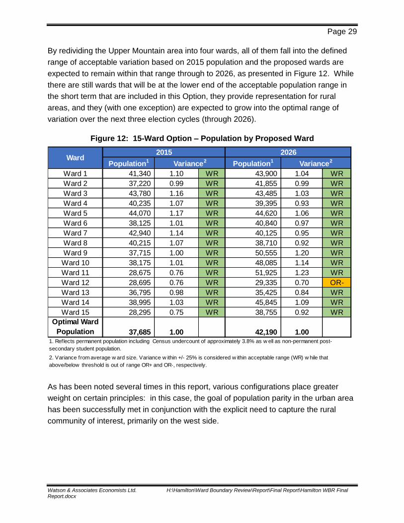
By redividing the Upper Mountain area into four wards, all of them fall into the defined
range of acceptable variation based on 2015 population and the proposed wards are
expected to remain within that range through to 2026, as presented in Figure 12. While
there are still wards that will be at the lower end of the acceptable population range in
the short term that are included in this Option, they provide representation for rural
areas, and they (with one exception) are expected to grow into the optimal range of
variation over the next three election cycles (through 2026).
Figure 12: 15-Ward Option – Population by Proposed Ward
As has been noted several times in this report, various configurations place greater
weight on certain principles: in this case, the goal of population parity in the urban area
has been successfully met in conjunction with the explicit need to capture the rural
community of interest, primarily on the west side.
Population1 Population1
Ward 1 41,340 1.10 WR 43,900 1.04 WR
Ward 2 37,220 0.99 WR 41,855 0.99 WR
Ward 3 43,780 1.16 WR 43,485 1.03 WR
Ward 4 40,235 1.07 WR 39,395 0.93 WR
Ward 5 44,070 1.17 WR 44,620 1.06 WR
Ward 6 38,125 1.01 WR 40,840 0.97 WR
Ward 7 42,940 1.14 WR 40,125 0.95 WR
Ward 8 40,215 1.07 WR 38,710 0.92 WR
Ward 9 37,715 1.00 WR 50,555 1.20 WR
Ward 10 38,175 1.01 WR 48,085 1.14 WR
Ward 11 28,675 0.76 WR 51,925 1.23 WR
Ward 12 28,695 0.76 WR 29,335 0.70 OR-
Ward 13 36,795 0.98 WR 35,425 0.84 WR
Ward 14 38,995 1.03 WR 45,845 1.09 WR
Ward 15 28,295 0.75 WR 38,755 0.92 WR
Optimal Ward
Population 37,685 1.00 42,190 1.00
2. Variance from average w ard size. Variance w ithin +/- 25% is considered w ithin acceptable range (WR) w hile that
above/below threshold is out of range OR+ and OR-, respectively.
1. Reflects permanent population including Census undercount of approximately 3.8% as w ell as non-permanent post-
secondary student population.
Ward2015
Variance2
2026
Variance2

Page 30
Watson & Associates Economists Ltd. H:\Hamilton\Ward Boundary Review\Report\Final Report\Hamilton WBR Final Report.docx
The overall evaluation of the 15-ward Option is summarized in Figure 13.1 This Option
has successfully addressed the two population principles and the community of interest
principle, while only proposing two wards that include areas above and below the
Escarpment (in the Ancaster and Dundas-Greensville area). Portions of Highway 403
cut through two wards but other boundaries use plausible easily-identified markers. The
coherence and population distribution of the proposed wards contributes to effective
representation even though significant population projections are expected in two wards
with large areas. On the whole, this Option could be defended to the O.M.B. as more
equitable than the present system over the time period envisioned for a new ward
system (three election cycles) even though it may not realize its full potential until after
the first election (2018).
Figure 13: Evaluation Summary of 15-Ward Option
Principle
Does Proposed Ward Boundary Structure Meet
Requirements of Principle?
Comment
Representation by Population Yes All wards within desired range of variation but three close to bottom of the range
Population and Electoral Trends
Largely successful One ward below the range, all others within acceptable range
Means of Communication and Accessibility
Partially successful
Generally clear markers; limited access highways cut through three wards
Geographical and Topographical Features
Largely successful Two wards on the western side include neighbourhoods above and below the Escarpment
Community or Diversity of Interests
Yes Communities of interest not divided internally but some new groupings are proposed
Effective Representation Largely successful No significant dilution of representation but major growth forecast in two wards with large geographic areas
1 In the Options included herein, ward numbers that correspond to the present wards are used wherever possible. It would be appropriate for wards in a revised system to be re-numbered (or named) to reflect a City-wide system.

Page 31
Watson & Associates Economists Ltd. H:\Hamilton\Ward Boundary Review\Report\Final Report\Hamilton WBR Final Report.docx
5.2 16-Ward Option
Hamilton’s City Council, at present, consists of fifteen Councillors elected in fifteen
wards and a Mayor elected at-large. It is within the powers of a Council to modify the
“composition of council” (as it is called in the Municipal Act) but the position of Mayor is
not within the powers of Hamilton Council to change, since all municipalities in Ontario
must have a “head of council” elected at-large.
As previously discussed, a 16-ward model (Preliminary Option 4) was the preferred
choice of the public in the second round of public consultation. There are merits to a
16-ward model in the context of Hamilton. These include:
Making it possible to achieve both a better population balance and more
coherent individual wards if the composition of council is increased.
The addition of one seat means that the population of an optimal ward and range
of variation are adjusted downward thereby contributing to the possibility that
some wards can be designed with smaller populations and still be deemed to
deliver parity.
Returning to an even number of Councillors means that when all members of
Council are participating in a decision, the Mayor could cast a tie-breaking vote
rather than voting to create a tie – a move that blocks actions but cannot affirm a
decision since a tied vote is deemed to be a lost vote. In other words, it would be
a contribution to better governance for the City.
The City of Hamilton has seen notable population growth since amalgamation
and the implementation of a 15-ward system. At the time of amalgamation, the
average size of a ward with respect to permanent population was approximately
34,000.1 In 2015, the average size of a ward increased to approximately 36,500
and by 2026 it is forecast to increase to 40,900. In a 16-ward configuration, the
current permanent population per ward (based on 2015 population figures) would
be comparable to the population per ward under the 15-ward structure in 2001.
In other words, over the 2001-2015 period, the City’s population has increased
by the equivalent of one ward.
1 Includes Census undercount of approximately 4% but excludes non-permanent post-secondary student population.
Page 32
Watson & Associates Economists Ltd. H:\Hamilton\Ward Boundary Review\Report\Final Report\Hamilton WBR Final Report.docx
It is estimated that an additional Councillor would add approximately $230,000 to
the City’s annual operating budget.1 This figure would represent about a 0.01%
increase to the City’s annual operating budget.2
Public responses and further analysis have led to a hybrid 16-ward Option; that is, it
incorporates many of the features of the preliminary designs from the Interim Report
that were labelled “Option 4” but has addressed some of the shortcomings identified
through the public consultations.
The 16-ward Option is presented in Figure 14 with more detailed mapping and
descriptions of proposed ward boundaries provided in Appendix C. The key
characteristics of this Option include:
Six wards below the Escarpment aligned north-south from Highway 403 to the
Grimsby boundary;
Five wards on the central and west Mountain from Upper Centennial Parkway to
Highway 403 with two running from the Mountain brow to the Lincoln Alexander
Parkway and two from the Lincoln Alexander Parkway south to Twenty Road.
The fifth ward would run from Upper Ottawa Street to Upper Centennial Parkway
north and from the Mountain brow to Twenty Road-Rymal Road;
A ward consisting of a very large geographic area that includes Upper Stoney
Creek from Upper Centennial Parkway to the Grimsby boundary and the
southeast quadrant of the City below Twenty Road-Rymal Road and over beyond
the John C. Munro Hamilton International Airport;
A proposed ward centred on Ancaster;
A proposed ward to include Dundas and Greensville;
A proposed rural ward that circles the western suburban communities; and
A proposed ward based on Waterdown.
1 This figure reflects the salary of one Councillor and an Administrative Assistant and discretionary items. This calculation is based on discussions with City staff. 2 City of Hamilton approved 2016 gross operating budget (rate and tax supported) is $1,643,014,160.

Page 33
Watson & Associates Economists Ltd. H:\Hamilton\Ward Boundary Review\Report\Final Report\Hamilton WBR Final Report.docx
Figure 14: 16-Ward Option

Page 34
Watson & Associates Economists Ltd. H:\Hamilton\Ward Boundary Review\Report\Final Report\Hamilton WBR Final Report.docx
With an additional ward to consider, this Option uses a lower optimal size for a ward
(35,330 in 2015 as opposed to 37,685 in a 15-ward design) and a range of variation in
which smaller ward populations are judged acceptable, as shown in Figure 15. As can
be expected, areas in the City where population is concentrated fall closer to the top of
the range (including one outside the range) and wards in areas of lower population
density tend towards the lower end of the range or outside it. While proposed Wards 11
and 15 are moderately below the minimum population threshold in 2015, based on
recent development activity and forecast growth, Ward 11 is expected to be above the
minimum threshold by the election in 2018, while Ward 15 will approach the threshold
by that year and is expected to surpasses the minimum threshold in time for the 2022
election. Wards 13 and 14, however, are on the western and northern fringes of the
City where growth is not forecast, and are expected to continue to be at the lower end of
the population range throughout the forecast period. In comparison, proposed Ward 16
will remain marginally above the maximum desired population variance through 2026.
Figure 15: 16-Ward Option – Population by Proposed Ward
Population1 Population1
Ward 1 41,340 1.17 WR 43,900 1.11 WR
Ward 2 40,635 1.15 WR 45,225 1.14 WR
Ward 3 40,360 1.14 WR 40,120 1.01 WR
Ward 4 40,235 1.14 WR 39,395 1.00 WR
Ward 5 44,070 1.25 WR 44,620 1.13 WR
Ward 6 39,500 1.12 WR 37,880 0.96 WR
Ward 7 33,460 0.95 WR 31,285 0.79 WR
Ward 8 38,225 1.08 WR 36,785 0.93 WR
Ward 9 28,390 0.80 WR 43,530 1.10 WR
Ward 10 38,175 1.08 WR 48,085 1.22 WR
Ward 11 24,230 0.69 OR- 46,105 1.17 WR
Ward 12 39,425 1.12 WR 44,980 1.14 WR
Ward 13 28,815 0.82 WR 27,775 0.70 OR-
Ward 14 19,500 0.55 OR- 18,910 0.48 OR-
Ward 15 23,100 0.65 OR- 33,580 0.85 WR
Ward 16 45,810 1.30 OR+ 50,695 1.28 OR+
Optimal Ward
Population 35,330 39,555
2. Variance from average w ard size. Variance w ithin +/- 25% is considered w ithin acceptable range (WR) w hile that
above/below threshold is out of range OR+ and OR-, respectively.
1. Reflects permanent population including Census undercount of approximately 3.8% as w ell as non-permanent post-secondary
student population.
Ward2015 2026
Variance2 Variance2

Page 35
Watson & Associates Economists Ltd. H:\Hamilton\Ward Boundary Review\Report\Final Report\Hamilton WBR Final Report.docx
There is a better capacity to group together communities of interest into units of
representation in a 16-ward system. In contrast to the fifteen ward Option, for example,
the four southern and western wards (11, 12, 13 and 14) are each coherent entities built
upon long-standing and well-understood inter-connections of economic and social
networks. As a result, the reservations expressed by the O.M.B. in relation to the
representation of the fringes of the municipality in the 2002 Ottawa ward by-law are not
applicable.
The overall evaluation of the 16-ward option is summarized in Figure 16. This design
can provide to residents of all parts of Hamilton with equitable and effective
representation over the next three elections. Despite the wide variations in population
density and forecast population growth, the population principles are largely met for
2015 and 2026. Only two wards include areas above and below the Escarpment (in the
Ancaster and Dundas-Greensville area). Portions of Highway 403 cut through two
wards but other boundaries use plausible easily-identified markers. The coherence and
population distribution of the proposed wards contributes to effective representation
since higher population wards are comparatively small in area and the major rural
community of interest is preserved despite its low population.
Figure 16: Evaluation Summary of 16-Ward Option
Principle
Does Proposed Ward Boundary Structure Meet
Requirements of Principle?
Comment
Representation by Population Largely successful
One ward above the top of the range, three below the range
Population and Electoral Trends
Largely successful
One ward just above the top of the range, two below the range
Means of Communication and Accessibility
Partially successful
Generally clear markers; limited access highways cut through two wards
Geographical and Topographical Features
Largely successful
Two wards include neighbourhoods above and below Escarpment
Community or Diversity of Interests
Yes Communities of interest not divided internally but some new groupings to experience are proposed
Effective Representation Largely successful
No significant dilution of representation and all wards are coherent collections of communities

Page 36
Watson & Associates Economists Ltd. H:\Hamilton\Ward Boundary Review\Report\Final Report\Hamilton WBR Final Report.docx
6. Recommendations
This report has evaluated the existing ward structure in terms of the principles
established for the 2015-16 Ward Boundary Review and the public input received. This
evaluation suggests strongly that the existing ward boundary configuration does not
meet the expectations of the guiding principles. The existing ward structure will not be
workable in the future and this review has concluded that the City would be better
served by an alternative configuration.
The two Options presented here successfully address shortcomings identified in the
present system by providing wards that are better balanced in population now and over
the next three elections while accommodating a significant geographic community of
interest (rural Hamilton) and the various urban neighbourhoods materializing across the
City.
Furthermore, all of the Options placed before the community now or in the earlier stages
of the review have respected historical or distinct communities; all of them can be
identified in the two Options placed before Council in this report. They may have been
“partnered” with new neighbours but this was consciously done in ways that recognize
their similarities not their differences.
Ward boundaries must delineate one cluster of residents from another for electoral
purposes, but considerable attention has been paid in this review to placing boundaries
in locations that reflect the contemporary distribution of population in Hamilton. The City
is constantly changing so that hard lines that were drawn decades ago to separate one
municipal jurisdiction from another have softened to the point where they are no longer
reasonable ways to group residents together to deliver effective representation.

Page A-1
Watson & Associates Economists Ltd. H:\Hamilton\Ward Boundary Review\Report\Final Report\Hamilton WBR Final Report.docx
Appendix A – Public Consultation

Watson & Associates Economists Ltd. H:\Hamilton\Ward Boundary Review\Report\Final Report\Hamilton WBR Final Report.docx
Appendix A-1
Public Engagement Plan

1
City of Hamilton Ward Boundary Review Process
Community Engagement Plan
Contents: Contents: ........................................................................................................................................ 1Context ........................................................................................................................................... 2Outcome of the Ward Boundary Review ....................................................................................... 2Decision Maker .............................................................................................................................. 2Purpose of this Citizen Engagement Plan ...................................................................................... 2Outcomes of this Citizen Engagement Plan ................................................................................... 2Goals of Round One Consultations ................................................................................................ 2Goals of Round Two Consultations ............................................................................................... 2Roles in This Citizen Engagement ................................................................................................. 3Alignment with City Policy............................................................................................................ 3Meeting Locations of Round One Consultations ........................................................................... 5Round One Consultation Meeting Process..................................................................................... 5Round One Consultation Agenda ................................................................................................... 5Materials for Round One Consultation Events .............................................................................. 6Meeting Locations of Round Two Consultations .......................................................................... 7Round Two Consultation Meeting Process .................................................................................... 7Round Two Agenda ....................................................................................................................... 7Materials for Round Two Consultations ........................................................................................ 7

Community Engagement Plan – City of Hamilton Ward Boundary Review process.
For Report Appendix – Watson & Associates, October 2016 2
Context The City of Hamilton commissioned Watson & Associates Economists Ltd., in association with ICA Associates Inc., Trust Learning Solutions and Robert J. Williams (the Consultant Team), to conduct a comprehensive review of the municipal ward system. The Request for Proposal and resultant Terms of Reference for the project specified two rounds of public consultation and engagement in the process. The City is in the midst of raising the standard for citizen engagement based on a Public Engagement Charter. The Consultant Team has endeavoured to live up to this high standard even though the Charter has not yet been converted into policy. This document embodies the City’s principles and converts them into procedures.
Outcome of the Ward Boundary Review The Ward Boundary Review process will develop and present to the City of Hamilton some alternative ways to ensure effective and equitable arrangement of the City of Hamilton’s electoral wards.
Decision Maker Ultimately, the Council of the City of Hamilton will decide which ward design alternative to adopt, including the option of staying with the status quo. The Ward Boundary Review Study provides expert input into their decision.
Purpose of this Citizen Engagement Plan To engage the people of Hamilton in a manner that provides valuable input to the
evaluation of the existing ward structure and development of alternative ward boundaries. To ensure Council that ward boundary alternatives reflect municipal vision, principles of
the Public Engagement Charter, and community input.
Outcomes of this Citizen Engagement Plan Citizens will learn about the reason for the Ward Boundary Review and the key factors that
will be considered in the review. Citizens will provide useful input to the Consultant Team in the evaluation of the existing
system and researching design alternatives on behalf of Council. Citizens will have a sense that their input might genuinely influence the review.
Goals of Round One Consultations Interested citizens of Hamilton will learn about the review process and the design principles given in the Terms of Reference for the project. They will assess the strengths and weaknesses of the current ward boundary structure, then rank the design principles in order of importance for consideration in the development of alternatives. This ranking of design principles is important because it will inform the Consultant Team on how to narrow the range of alternatives for development and exploration.
Goals of Round Two Consultations Interested citizens of Hamilton will learn about the alternative ward boundary options, assess the trade-offs among them using the adopted design principles, indicate their preferences, and provide thoughtful feedback to the Consultant Team that informs the development of recommended options.

Community Engagement Plan – City of Hamilton Ward Boundary Review process.
For Report Appendix – Watson & Associates, October 2016 3
Roles in This Citizen Engagement The City and the Consultant Team will be collaborating throughout the Review. The City will use its expertise in communications and logistics for:
Website hosting, design, and maintenance; Communications using: social media, traditional media, posters, and mailings; Promotional materials publication and distribution; Media relations; Advertising; Venue logistics: find, book, equip, and provide refreshments as needed; Outreach to community groups; Branding; and Added forms of engagement not contained in the original terms of reference.
The Consultant Team will use its subject matter expertise for:
Informing participating citizens about the subject of ward boundary reviews; Group process design and facilitation; Content for communications, such as descriptive text added to a website; Key messages advice to the City; Capturing and documenting the basic components of the citizen input for future reference;
and Reviewing any citizen input captured by the City from their social media and web-based
sources.
Alignment with City Policy An engagement plan is essential to the Ward Boundary Review because it upholds two overarching pillars of the City:
The existing Vision for the City of Hamilton: “To be the best place in Canada to raise a child, promote innovation, engage citizens and provide diverse economic opportunities.”
The Core Principles of the City’s new Public Engagement Charter expand on the elements of the vision:
o Transparency and trust; o Accountability and action; o Inclusion and diversity; o Create opportunities for active participation; o Collaboration, co-operation and shared purpose; o Ongoing engagement and open communication; o Learning, reflection and evaluation; and o Capacity for engagement.
The public engagement plan of the Ward Boundary Review process seeks to align itself with the City’s Core Principles of Public Engagement:

Community Engagement Plan – City of Hamilton Ward Boundary Review process.
For Report Appendix – Watson & Associates, October 2016 4
Core Principles of Public Engagement Ward Boundary Review Design Implication
1. Trust and transparency A website is being created by City staff to share all background information, reports and location of public consultations. City staff will monitor social media comments. Consultant Team will provide content for the City in a timely fashion to use in updating the project web page.
2. Accountability and action
Products/outputs of each round of engagement will be reviewed by the Consultant Team and referenced in their analysis, design, and recommendations.
3. Inclusion and diversity Public meetings will be held in different parts of the City scheduled at different times of the day and days of the week. City staff will book functional meeting rooms that are wheelchair accessible, with ample space to move around during interactive sessions. Consultant Team will ensure that materials shared in public meetings will use both visual and auditory processes. Facilitators will ensure that the interactive components of the meeting will engage different ways of learning and communicating: kinesthetic through body movement and making tangible products, interpersonal through small and large group discussions, etc. Language of the public meetings will be English.
4. Create opportunities for active participation
Group process design begins with reframing the objectives in terms of what the participants need to know, learn, decide or produce. Face-to-face meetings with the public will include interactive components that encourage participants to meet new people and ideas without unnecessary criticism. Small group discussions invite participants to record their own ideas. Sharing key insights will be through the use of index cards, push-pins, sticky notes and lists projected on an overhead screen. Large display boards will contain the key information and be available for review at the beginning of the event. Questions will be organized to build one on the other and reveal deeper insights, not just opinions and positions.
5. Collaboration, co-operation and shared purpose
The City will be taking the lead role in public communications. Communication and outreach will be through a number of media vehicles. City staff will invite Councillors to reach out through their networks, the media will be asked to play a role, local community groups will be engaged directly in soliciting participation from their membership. A set of “participation guidelines” will be reviewed with participants at public meetings in order to set an inclusive, collaborative tone.
6. Ongoing engagement and open communication
The City will set up, manage and monitor a website which will be changing throughout the life of the review. The City’s own social media outlets will be receiving and encouraging community conversations.
7. Learning, reflection and evaluation
The design of the engagement process was refined after consulting with elected representatives and City staff. The design of the second round of consultations will reflect some of the lessons learned from the first round. Public meetings will end with a short reflective dialogue on the event.
8. Capacity for engagement
The first round is partly educational about the topic and the process. Questions of clarification will be asked and answered. Participants will be asked the deeper questions after the informational ones.

Community Engagement Plan – City of Hamilton Ward Boundary Review process.
For Report Appendix – Watson & Associates, October 2016 5
Meetings for Round One Consultations Nine 3-hour meetings to be held at locations throughout the City of Hamilton.
Round One Consultation Meeting Process Purpose: Interested citizens of Hamilton will learn about the review process and the design principles given in the terms of reference for the project. They will assess the strengths and weaknesses of the current ward boundary structure after ranking the design principles in order of importance for the future. This ranking of design principles is important because it will inform the Consultant Team on how to narrow the range of alternatives for development and exploration.
Round One Consultation Agenda 1) Brief Open House Purpose: To introduce the topic and understand the participants’ perspectives. Process: Individually review informative display boards and indicate (with a pin) on a map where
each participant lives. 2) Welcome, context, overview Purpose: To equip people to engage with one another comfortably. Process: Brief presentation describing the agenda and participation guidelines.
3) The Ward Boundary Review Presentation (25 minutes) Purpose: To equip people to discuss the topic of ward boundary review. Process: Presentation by an expert, reviewing the maps, history, terms of reference (especially the
design principles), and how the input will influence the work. 4) Clarification Discussion (5 + 10 + 10 = 25 minutes) Purpose: To ensure people are clear about the topic. Process: 1) A brief table discussion and note taking and 2) sharing questions with the whole group,
followed by 3) answers to what can be answered by the presenter. Key question: “What questions of clarification do you have?”
5) Current Situation Discussion (10 + 10 + 10 = 30 minutes) Purpose: To better understand and apply the City’s design principles to the current ward
boundaries in order to build up a principled impression of strengths and weaknesses. Process: 1) Small group discussions of the design principles and note taking about strengths and
weaknesses of the current situation, 2) sharing some key insights from each small group with the large group, and 3) a short whole-group discussion of their summary.
Key question: “What are some of the strengths and weaknesses of the current ward system?” 6) Ranking of Design Principles for the Future (10 + 10 + 10 + 10 = 40 minutes) Purpose: To apply the design principles this time for future consideration. Process: 1) Small groups review the design principles again and discuss which are important for
the ward system to reflect and uphold in the future; 2) individually select the top 3 most important design principles to apply.
Key question: “What principles do we want the ward system to uphold and reflect in Hamilton?” 7) Wrap-up and next steps (10 + 10 = 20 minutes) Purpose: To summarize the event, learn how the results will be used, and how to stay engaged. Process: One short presentation and one short whole-group discussion. Key Question: “What will we tell people who were not here when they ask what happened?”

Community Engagement Plan – City of Hamilton Ward Boundary Review process.
For Report Appendix – Watson & Associates, October 2016 6
Materials for Round One Consultation Events Stacking chairs for 35 people, with an additional 75 or more available for a potentially large
crowd. Folding tables, preferably round, 6 set up with 6 chairs per table, with another 8 tables ready to
be set up if a large crowd arrives. Large display boards including:
“Engagement Charter” including vision, mission, and principles diagram (supplied by the City – because it is theirs and they can re-use it);
“Where do YOU come from?” A large simple B&W map of the current ward boundaries and major streets on a foam-core panel (so pushpins can be stuck through it);
“The Ward Boundary Review Process” containing: o A simple flow chart of the whole process including a “you are here” marker, next
steps and contact information to add input; and o Website URL and Twitter hashtag and phone number selected by the City for
Communications Wall Posters:
Purpose and Agenda; Participation Guidelines poster posted near the agenda:
o Everyone has wisdom; o We need everyone’s wisdom for the wisest results; o There are no “wrong” answers; o The whole is greater than the sum of its parts; and o Everyone will “hear” and “be heard.”
Pre-printed (B&W on plain bond paper) 3’x3’ tablecloths with questions and places to write answers during small group discussion.
Pre-printed large vertical strips of paper (maybe 18” to 24” wide by 36” tall) each containing another of the design principles from the Terms of Reference printed large at the top. When hung together on an accessible wall space these will be:
o Referred to by the presenter; then o Used by participants for their coloured sticky notes ranking the top three principles.
Sets of three coloured sticky notes for individuals to use for ranking the principles Projector and screen. A small set of chunky marker pens for writing/drawing on every tablecloth. Sign-in sheets so the City can keep in touch with participants and to send them a thank-you
note. A registration table near the entrance. If supplied by the City or a sponsor, a refreshments table. Sets of small-headed colour pushpins for participants to stick in the map during the open house
(colour coded to help identify where the consultation was located). Microphone (wireless preferred), amplifier and loudspeaker.

Community Engagement Plan – City of Hamilton Ward Boundary Review process.
For Report Appendix – Watson & Associates, October 2016 7
Meetings for Round Two Consultations Nine 3-hour meetings to be held at locations throughout the City of Hamilton. The goal is to complete the consultations before the end of June in order to capture as
many participants as possible before the summer vacation season begins and to allow time for reviewing the input before developing the final options to Council.
Round Two Consultation Meeting Process Purpose: Interested citizens of Hamilton will learn about the alternative ward boundary structures, assess the trade-offs among them using the City’s ranked design principles, indicate their preferences, and provide feedback to the Consultant Team. Allowance is made for individuals to examine all the alternatives in an informed and informal manner. Participants will be equipped with a “passport” to allow them to take notes and keep track of both the design principles and the various options. The process requires casual 1:1 support and instruction with less group facilitation.
Round Two Agenda 1) Open house; 2) Welcome and overview of the event; 3) Presentation on input from Round One consultations; 4) Presentation on the draft alternative ward boundaries; 5) Discussion of the alternatives using the input from the round one consultations (Q&A); 6) Participations were handed a passport in order to take notes and rank their preferences; 7) Indication of preferences as “walkabout” with subject matter experts very accessible; 8) Discussion of assumptions and reasons behind preferences; and 9) Wrap-up and next steps.
Materials for Round Two Consultations A dozen display board easels for the preliminary options and explanatory posters; Chairs arranged for a presentation; Projector and screen for a presentation; Reception table; Tables for participants to write their answers at, if they chose; and “Passport” booklets for each participant containing information about the overall process,
ranked design principles from Round One consultations, a few defining characteristics of the ward boundary options, space to express opinions, and some evaluation questions.

Meeting Locations of Round One Consultations:
Nine 3-hour meetings were held between February 3rd and February 27th, 2016, at locations throughout the City of Hamilton, as summarized below.
This included seven weekday meetings scheduled in the evenings and two meetings scheduled on Saturday afternoons.
Locations of Round One Consultations
Meeting # Venue Date/Time
1 Harry Howell Arena Wednesday, February 3, 2016
6:00-9:00 pm
2 Canadian Warplane Heritage Museum Tuesday, February 9, 2016
6:00-9:00 pm
3 Old Beasley Community Centre Wednesday, February 10, 2016
5:30-8:30 pm
4 Sackville Seniors Centre Thursday, February 11, 2016
6:00-9:00 pm
5 Rockton Fairgrounds Tuesday, February 16, 2016
6:00-9:00 pm
6 Ancaster Rotary Centre Wednesday, February 17, 2016
6:00-9:00 pm
7 Stoney Creek Recreation Centre Saturday, February 20, 2016
12:30-3:30 pm
8 Bocce Club – Chedoke Twin Pad Arena Monday, February 22, 2016
6:00-9:00 pm
9 Dundas Lions Memorial Community Centre Saturday, February 27, 2016
12:30-3:30 pm

Meeting Locations of Round Two Consultations
Nine 3-hour meetings were held between June 9th and June 29th, 2016, at locations throughout the City of Hamilton, as summarized below.
This included seven weekday meetings scheduled in the evenings and two meetings scheduled on Saturday afternoons.
Locations of Round Two Consultations
Meeting # Venue Public Meeting Date/Time
1 Sir Winston Churchill Recreation Centre Thursday, June 9, 2016
6:00-8:30 pm
2 Tim Hortons Field Saturday, June 11, 2016
12:30-3:30 pm
3 Mountain Arena Tuesday, June 14, 2016
6:00-9:00 pm
4 Ancaster Rotary Centre Thursday, June 16, 2016
6:00-9:00 pm
5 Westdale Secondary School Friday, June 17, 2016
6:00-9:00 pm
6 Waterdown Legion Hall Monday, June 20, 2016
6:00-9:00 pm
7 Winona Community Centre Thursday, June 23, 2016
6:00-9:00 pm
8 Rosedale Arena Saturday, June 25, 2016
12:30-3:30 pm
9 Binbrook Agricultural Hall Wednesday, June 29, 2016
6:00-9:00 pm

Watson & Associates Economists Ltd. H:\Hamilton\Ward Boundary Review\Report\Final Report\Hamilton WBR Final Report.docx
Appendix A-2
Round 1 of Public Consultation

City of Hamilton Ward Boundary Review
Public Information and Engagement Workshop – Round 1
Comments/Feedback Form
1. What are the key strengths of the current ward boundary system in Hamilton?
______________________________________________________________________
______________________________________________________________________
______________________________________________________________________
______________________________________________________________________
______________________________________________________________________
______________________________________________________________________
2. What are the key weaknesses of the current ward boundary system in Hamilton?
______________________________________________________________________
______________________________________________________________________
______________________________________________________________________
______________________________________________________________________
______________________________________________________________________
______________________________________________________________________
3. What issues do you believe are most important to address in the ward boundary
review process?
______________________________________________________________________
______________________________________________________________________
______________________________________________________________________
______________________________________________________________________
______________________________________________________________________
______________________________________________________________________
4. Additional comments?
______________________________________________________________________
______________________________________________________________________
______________________________________________________________________
______________________________________________________________________
______________________________________________________________________
Thank you for your interest and participation.
Please leave your completed form in the Comments Box.
Or return to:
Email: [email protected]
Return of comments is requested by March 3, 2016.

• • • •
• • • •
• • • •

Hamilton Ward Boundary Review
Public Consultation Round 1 – Feedback Received via Comment
Sheets Circulated at Public Open Houses
What are some of the STRENGTHS of the current ward boundaries?
Well-established (i.e. they've been around for a long time, people know which ward they
reside in)
Recognizes Geographic Areas
Fits within Historical Boundaries
Suburban and Rural Divide
What are some of the WEAKNESSES of the current ward boundaries?
It is not representative of the population
The Wards vary in size
Maintains interest of rural versus urban interest preventing a sense of overall community
What issues do you believe are most important to address in the ward boundary review
process?
Ensuring equal population per ward, while also ensuring there is no conflict between
urban and rural divide
Community identity - common interest
Geographic and Topographic features
Effective Representation
Diversity of Interest
Keeping the Historical Guides
Even Ward Sizes
Separation of Rural Zone
Greenbelt Recognition
Additional Comments
This boundary review needs to be done as population patterns have changed over time
Additional ward on mountain + eliminate rural wards
Hamiltonians from all over must realize we are all in this together and not separate
entities
A community attitude must be maintained
Regardless of rural boundaries, Councillors should represent the ward and work for
good of all

Hamilton Ward Boundary Review
Public Consultation Round 1 – Workshop Group Sessions
“Tablecloth” Responses Summary and “Voting” Results on Guiding
Principles
What are some of the STRENGTHS of the current ward boundaries?
City-Wide:
Strong geographical features
Contiguous
Preserves Neighbourhoods and shows the uniqueness of each
Diversity and Identity is evident
Ward 14 is the best example of a Ward with multiple small communities that have come
together
Familiarity
Ancaster and Dundas Area:
Dundas is Dundas
Established heritage
Neighbourhood identity and cohesion maintained
Protects suburban Town’s character
Reflects the uniqueness of the communities (e.g. rural communities)
Rural Area:
Ward 14 is a great example of effective representation
Stability after amalgamation
Geographically equitable
The current ward system provides for effective representation in the suburban and rural
areas
Inner City:
Preserves neighbourhoods
Legacy Communities
Mountain:
Current system reinforces existing interest of different socio-economic & cultural
interests
Geographically equitable
There is strength is having a balance between rural and urban wards as it creates
balance
Stoney Creek:
Easy to identify Stoney Creek
Self-contained

Strong sense of community
What are some of the WEAKNESSES of the current ward boundaries?
City-Wide:
Major split/divide between Urban and Rural
Inequitable representation
Ward 11 feels like a hodgepodge
Population imbalance
Urban-Suburban divide
Ancaster and Dundas Area:
Some Councillors want to maintain status quo which inhibits decision making for City-
wide issues and encourages "fiefdom"
Narrow perspective
City dominates rural areas
the current make-up does not represent natural communities (i.e. Ward 7 is very large)
Rural voice is often left out and does not have representation on committees (e.g. farm &
agriculture)
Rural Area:
City does not understand Rural issues
No services offered in rural area (Bus, Water, Sewer, etc.)
Current system divides us into socio-economic classes with different needs
Inner City:
Too conforming to boundaries of former municipalities
Better to have more wards, fewer residents
New wards should make sure lower income residents have fair representation
Councilors in high density and high needs areas are overwhelmed and under resourced
Urban issues underrepresented (1/3 pop = 1/2 Council)
Some communities of interest that are not adequately represented
Mountain:
Major Split between urban & rural
Population representation is unfairly distributed
Tunnel vision Councilors (worrying on just your ward)
No representation by population
East end:
Winona should be with Stoney Creek (education & ward 10)
The mountain may be an artificial barrier
Amalgamation animosity

Ward 9 & 11 split by the escarpment
Interest pitted against each other
Where and how should the present ward system be changed? (if you have specific
suggestions)
Mount Hope:
Reduce to 9-11 Councillors
Create a spoke & wheel ward that includes city to rural for all councilors
Councillors would have to gain a knowledge of city/medium density / rural issues
Old Beasley (Downtown):
Ancaster could reasonably take in Copetown and Mount Hope. The schools feed into
Ancaster High
Constituents elect trustees as well as City Councillors. Take into consideration the
make-up of school communities
Sackville Hill:
Start from zero - choose optimal number of wards first
Merge some of the rural wards
Dividing some of the urban wards
Highest population areas
More equitable representation must be implemented
Council changed to ward rep and Regional elected at large
Rockton Fairgrounds (Rural):
Current ward system works well to represent each ward's needs and community interest
Ward 14 could encompass part of Ward 15 west of Highway 6 to increase population of
ward 14
Ward 15 will increase population in Waterdown
Orkney could be added to Ward 14 also to increase population
To increase the population of Ward 14, the only option is to join (partially) with another
Ward. This would increase the size of Ward 14 to a size which would be impossible for
a Councilor to manage
Regrowth of Waterdown - add to Ward 14 section of Ward 15, everything West of
Highway 6
We want No more expense - No more Councillors, No less
We do not want to lose any Rural Councillors
Ancaster:
Following the Federal riding boundary, have 3 Ward representatives elected into each
riding (divide each Federal riding into 3 Wards)
Divide Ward 11 into two as it has population growth
Stoney Creek:
Use escarpment as a boundary for Wards 9 & 11
Dundas:
Consider larger geographical wards with 2,3,4,5 reps elected at large in the wards
Look again at the idea of having a Regional Municipality, as before
Community nodes (e.g. Copetown/ Lynden) need to be kept together in one ward
If Necessary, Ward 13 west of Highway 6, south of #5 to either Middletown rd. or Hwy 52
to Jerseyville Rd. people who live in Greensville & Glen Drummond survey to Copetown
area already think they are part of Dundas
Propose 3 "at-large" Councillors to represent wards 1-5, wards 6-9, and wards 10-15
"Impose 1 or 2 year term limits
benefits: Injects new blood into Council,
creates profile to challenge incumbent in future election,
provides ""apprenticeship"" for new Councillors to lead ward work and duties,
could be springboard for future mayoral candidates"
Extend ward 10 - below mountain / lakefront to east boundary
Extend ward 13 - capture Greenbelt areas below mountain from wards 12 & 14
Use Upper Sherman as east/west boundary for wards 6&7
Use Hwy. 6 as east/west boundary for wards 14&15
Extend ward 5 to Grays Rd. from ward 9 (below mountain)

LocationRepresentation
by Population
Population and
electoral trends
Means of
communication
and accessibility
Geographical and
topographical
features
Community or
diversity of
interests
Effective
RepresentationTotal Votes
Harry Howell Arena(Flamborough) 5 1 3 9 13 14 45
Canadian Warplane Heritage Museum (Mount Hope) 4 1 1 4 5 4 19
Old Beasley Community Centre 10 3 0 2 7 5 27
Sackville Hill Seniors Recreation Centre 4 1 2 3 6 2 18
Rockton Fairgrounds 4 0 1 18 18 21 62
Ancaster Rotary Centre 5 2 1 2 2 4 16
Stoney Creek 4 1 2 3 6 2 18
Bocce Club - Chedoke Twin Pad Arena 21 0 7 13 7 21 69
Dundas Lions Memorial Community Centre 5 2 1 11 11 9 39
Total Votes 62 11 18 65 75 82 313
Ranking 4 6 5 3 2 1
Guiding Principles for the Hamilton Ward Boundary Review (2016)
Hamilton Ward Boundary Review - "Voting" Results on Guiding Principles at Round 1 Public Meeting/Workshops

Page 1.
Watson & Associates Economists Ltd. \\10.0.0.41\hdrive\Hamilton\Ward Boundary Review\PIC\Hamilton WBR Consultation Round 1 Online Feedback Key Findings.docx
City of Hamilton Ward Boundary Review
Online Comments/Feedback Form – Summary of Submissions Received
February 3 – March 3, 2016
Received 62 submissions
Respondents were asked about the key strengths/weaknesses in the current Hamilton
ward boundary system:
Key strengths of current system:
o The dominant response was “none”. Of the few key strengths identified include:
Respects/maintains communities of interest and pre-amalgamated
municipalities
Well established and understood
Gives rural population a “voice”
Key weaknesses of current system (in order of number of responses – highest to
lowest):
o Population imbalance
o Promotes urban vs. suburban/rural divisiveness and “us vs. them” mindset on
Council
o System based on pre-amalgamated municipality lines which makes it difficult to
move forward as an amalgamated city.
o Boundaries don’t follow logical lines.
High share of respondents indicated that Hamilton’s ward boundary system should be
redesigned and shown below:

Page 2.
Watson & Associates Economists Ltd. \\10.0.0.41\hdrive\Hamilton\Ward Boundary Review\PIC\Hamilton WBR Consultation Round 1 Online Feedback Key Findings.docx
Of those that responded that Hamilton’s ward boundary system should be redesigned,
respondents were asked what issues are most important to address in the redesign
process. Top responses are:
o Redesign should consider representation by population, preserving communities
of interest, effective representation
o Minimize urban vs. suburban/rural divide and “us vs. them” thinking and creates
a system based on an amalgamated city
o Add additional wards to address population imbalance
Of those that responded that Hamilton’s ward boundary system should not be
redesigned, respondents were asked why they believe the system should remain
unchanged. Only one respondent answered: “It's okay the way it is.”
Respondents were asked what principles should be given the highest priority in
redesigning the ward system in Hamilton. Population and Electoral Trends and
Representation by Population received the highest number of responses, followed
closely by Effective Representation. Communities of Interest received a moderate
number of responses, as illustrated below. Geographic and Topographic Features and
Communications and Accessibility received the lowest number of responses.
YES
95%
NO2%
No Response3%
Should Hamilton's Ward Boundary System be Redesigned?

Page 3.
Watson & Associates Economists Ltd. \\10.0.0.41\hdrive\Hamilton\Ward Boundary Review\PIC\Hamilton WBR Consultation Round 1 Online Feedback Key Findings.docx
12
12
21
34
39
39
0 10 20 30 40 50
Communication and accessibility
Geograph. And Topo Features
Communities of Interest
Effective Representation
Representation by Population
Population and Electoral Trends
Number of Responses
What principles should be given the highest priority in redesigning the ward system in
Hamilton?

Watson & Associates Economists Ltd. H:\Hamilton\Ward Boundary Review\Report\Final Report\Hamilton WBR Final Report.docx
Appendix A-3
Round 2 of Public Consultation

Hamilton Ward Boundary Review June 2016
“Passport” workbook for citizens to keep track of their ideas while reviewing possible ward boundary changes. 1
Passport
Purpose:
To gather detailed insights and suggestions from the citizens of Hamilton about what changes to the ward boundaries make
the most sense and WHY.
There are two pages in the middle of this passport for taking notes about each of the maps around the room.
Walk around the room to look closely at the maps of each option.
Make notes in this passport of what you think are the strengths and weakness of all the options.
Any questions raised for you can be written on the large Post-It notes at each location around the room.
After you have looked at all the options, pick up a worksheet marked “Preferences” and rank your top 1, 2, or 3 preferred options.
Please say WHY you prefer them.
Before you leave, drop this Passport booklet and your “Preferences” worksheet into the big box near the exit.
Hamilton Ward Boundary Review June 2016
“Passport” workbook for citizens to keep track of their ideas while reviewing possible ward boundary changes. 2
The Ward Boundary Review Process
In October 2015, the Council of the City of Hamilton decided to conduct a
ward boundary review. Consultants were hired and began their research.
In the fall of 2016 Council will decide what they want to do: keep the wards
the same, or change them based on expert recommendations that also
reflect public input.
The study has several phases including two rounds of public input:
STAGE ACTION PURPOSE 1 Council decided to do
a review – October 2015
To make an informed decision in the fall of 2016
2 Researched current situation – November to January
To gain insight from Councilors and stakeholders
3 Public consultation Round One – February 2016
To learn from the community and to give direction to the consultants on Guiding Principles, and issues of priority and importance
4 Develop draft options To apply the community’s sense of guiding principles, and show the community what’s possible
5 Public consultation Round Two – June 2016
To learn which options make the most sense to the community
6 Refine options – July and August 2016
To develop a short list of recommendations that reflect community feedback
7 Present recommendations to Council
Council receives the consultant’s recommendations through a committee of Council, for discussion.
8 Council decides what they want to do with ward boundaries – October 2016
Hamilton Ward Boundary Review June 2016
“Passport” workbook for citizens to keep track of their ideas while reviewing possible ward boundary changes. 3
Priority Guiding Principles
Guiding Principles for the study include:
Representation by Population;
Population and Electoral Trends;
Means of Communication and Accessibility;
Geographical and Topographical Features;
Community or Diversity of Interests; and
Effective Representation.
Participants in Round One of the public consultations (February
2016) ranked the Guiding Principles in order of importance.
Ranked higher were the principles of:
1. Representation by population;
2. Population and electoral trends; and
3. Community or diversity of interests.
Ranked lower were principles of:
4. Means of communication and accessibility; and
5. Geographical and topographical features.
The principle of “Effective Representation” is an overarching
principle that takes all the others into consideration.
This input from citizens was important because the options offered
for consideration in this second round of consultations attempt to
hold these prioritized principles.
Please consider these principles when thinking about the strengths and weaknesses of the draft options.
Hamilton Ward Boundary Review June 2016
“Passport” workbook for citizens to keep track of their ideas while reviewing possible ward boundary changes. 4
Summary of Options Displayed on Maps
Options (…and a few reminder points)
Population 2015 2026
1: Parallel Federal Constituencies Five Federal constituencies divided into 3 wards each. Niagara Escarpment as a boundary for most wards that abut it.
2 wards more than 125% above the current average population per ward. 2 wards below 75%.
3 wards more than 125% above the average. 4 wards below 75%.
2A: Preserve pre-amalgamation balance 8 wards in the former City and 7 wards outside the City. Variation A.
3 wards more than 125% above the current average population per ward. 3 wards below 75%.
2 wards more than 125% above the average. 2 wards below 75%.
2B: Preserve pre-amalgamation balance 8 wards in the former City and 7 wards outside the City. Variation B.
4 wards more than 125% above the current average population per ward. 3 wards below 75%.
3 wards more than 125% above the average. 2 wards below 75%.
3A: Post-amalgamation 15 ward model 7 wards below Escarpment from Dundas to Winona, 5 wards along the south side of escarpment from Ancaster to Vinemont.
3 wards more than 125% above the current average population per ward. 2 wards below 75%.
1 ward more than 125% above the average. 2 wards below 75%.
3B: Post-amalgamation 15 ward model. 6 wards below the Escarpment from Dundas to Grays Road; 4 wards along the south side of the escarpment from Ancaster to First Road
1 ward more than 125% above the current average population per ward. 1 ward below 75%.
2 wards more than 125% above the average. 1 ward below 75%.
4A: Post-amalgamation 16 ward model. 7 wards below the Escarpment from Dundas to Winona; 5 wards along the Mountain from Ancaster to Vinemount; 4 wards in the central-west Mountain area. Variation A
1 ward more than 125% above the current average population per ward. 3 wards below 75%.
0 (zero) wards more than 125% above the average. 1 ward below 75%.
4B: Post-amalgamation 16 ward model. 7 wards below the Escarpment from Dundas to Winona; 5 wards along the south side of the escarpment from Ancaster to Vinemount; 4 wards in the central-west Mountain area. Variation B.
2 wards more than 125% above the current average population per ward. 3 wards below 75%.
0 (zero) wards more than 125% above the average. 2 wards below 75%.
4C: Post-amalgamation 16 ward model. 6 wards below the Escarpment from West Hamilton to Winona; 5 wards along the south side of the Escarpment from Ancaster to Vinemount; 5 wards in the central-west Mountain area.
0 (zero) wards more than 125% above the current average population per ward. 1 ward below 75%.
0 (zero) wards more than 125% above the average. 1 ward below 75%.
Current (Existing) Ward Boundary Structure: Based on boundaries set in 2001, some originating in the 1980s and 1990s. Reflect choices made during amalgamation.
2 wards more than 125% above the current average population per ward. 3 wards below 75%.
3 wards more than 125% above the average. 3 wards below 75%.

Hamilton Ward Boundary Review June 2016
“Passport” workbook for citizens to keep track of their ideas while reviewing possible ward boundary changes. 5
Your Notes
As you look at each of the options, keep track of your ideas and questions on this page if you wish. This is not an exam. This is a place to take notes, draw connection lines… whatever helps you keep track of all your ideas. What do you think about each option? How do they reflect the PRINCIPLES listed on page 3? What are some of the… …STRENGTHS of an option?
…WEAKNESSES of an option?
…QUESTIONS these options raises for me?
Hamilton Ward Boundary Review June 2016
“Passport” workbook for citizens to keep track of their ideas while reviewing possible ward boundary changes. 6
CURRENT City of Hamilton Ward Boundaries This is the map of the current (existing) ward boundaries in the City of Hamilton. It will help you to see the differences marked on the other maps.
Participants in Round One of the public consultations (February 2016) indicated that the weaknesses of the current boundaries made it important to consider alternative options.
When you look at the other possible options, consider the trade-offs. It is possible that the current model holds the community’s sense of priorities.
This option is called the “Current” option on pages 4 and 8.
Hamilton Ward Boundary Review June 2016
“Passport” workbook for citizens to keep track of their ideas while reviewing possible ward boundary changes. 7
Please answer the questions on the other side of this page. Then place the booklet in the big box marked “Preferences.”
THANKS! While you are at it, please answer these really easy questions too: 1) Which meeting is THIS one? (Please circle it) Meeting
# Venue Public Meeting Date/Time
1 Sir Winston Churchill Recreation Centre
Thursday, June 9 6:00-8:30 pm
2 Tim Hortons Field Saturday, June 11 12:30-3:30 pm
3 Mountain Arena Tuesday, June 14 6:00-9:00 pm
4 Ancaster Rotary Centre Thursday, June 16 6:00-9:00 pm
5 Westdale Secondary School Friday, June 17 6:00-9:00 pm
6 Waterdown Legion Hall Monday, June 20 6:00-9:00 pm
7 Winona Community Centre Thursday, June 23 6:00-9:00 pm
8 Rosedale Arena Saturday, June 25 12:30-3:30 pm
9 Binbrook Agricultural Hall Wednesday, June 29 6:00-9:00 pm
2) What did you think about THIS meeting?
Were you provided with enough information? Yes or No
Did you learn something about the ward system? Yes or No
Did you think your own input was valuable?
(Your input is on the other side of this page)
Yes or No
Was the passport and posters approach helpful for you? Yes or No
Would you encourage friends to attend one of these consultations? Yes or No
Hamilton Ward Boundary Review June 2016
“Passport” workbook for citizens to keep track of their ideas while reviewing possible ward boundary changes. 8
Preferences Please provide your best advice with insight. 1) Please RANK your top three options. If you only have 1 or 2, that’s
helpful too.
1 = MOST preferred 2 = second most preferred 3 = third most preferred
2) Please note WHY you answered the way you did. You might include the FEATURES you liked of various options.
Options (page 4)
RANK your 1, 2, or 3 MOST
preferred WHY Do you prefer it?
(What features do you prefer?)
1: Parallel federal constituency boundaries
2A: Preservation of pre-amalgamation balance
2B: Preservation of pre-amalgamation balance
3A: Post-amalgamation 15 ward system
3B: Post-amalgamation 15 ward system
4A: Post-amalgamation 16 ward system
4B: Post-amalgamation 16 ward system
4C: Post-amalgamation 16 ward system
Current (page 4 & 6) No change
Please drop this passport in the big box marked “Preferences.”

Aggregated Responses of Top 3 Choices from Second Round of Consultation
Total Count of Votes (Ranks 1, 2 and 3)
Passport Feedback
1: Parallel Federal
Constituency
Boundaries
2A: Preservation of
Pre-Amalgamation
Balance
2B: Preservation of
Pre-Amalgamation
Balance
3A: Post-
Amalgamation 15
Ward System
3B: Post-
Amalgamation 15
Ward System
4A: Post-
Amalgamation 16
Ward System
4B: Post-
Amalgamation 16
Ward System
4C: Post-
Amalgamation 16
Ward System Current: No Change
Sir Winston Churchill Recreation Centre & Tim Hortons Field 2 0 0 1 2 5 4 7 0
Mountain Arena 2 2 2 3 0 6 2 7 1
Ancaster Rotary Centre 0 9 3 6 2 4 5 5 5
Westdale Community Centre 0 0 0 1 2 2 4 8 0
Waterdown Legion Branch 551 0 2 0 1 0 1 2 1 0
Winona Community Centre 0 0 1 1 0 2 1 4 0Binbrook Agricultural Society 0 4 4 5 2 2 1 2 0
Total Votes 4 17 10 18 8 22 19 34 6
Ranking 9 5 6 4 7 2 3 1 8
Online Feedback
1: Parallel Federal
Constituency
Boundaries
2A: Preservation of
Pre-Amalgamation
Balance
2B: Preservation of
Pre-Amalgamation
Balance
3A: Post-
Amalgamation 15
Ward System
3B: Post-
Amalgamation 15
Ward System
4A: Post-
Amalgamation 16
Ward System
4B: Post-
Amalgamation 16
Ward System
4C: Post-
Amalgamation 16
Ward System Current: No Change
# Times Chosen 23 12 14 13 14 38 42 71 13
1: Parallel Federal
Constituency
Boundaries
2A: Preservation of
Pre-Amalgamation
Balance
2B: Preservation of
Pre-Amalgamation
Balance
3A: Post-
Amalgamation 15
Ward System
3B: Post-
Amalgamation 15
Ward System
4A: Post-
Amalgamation 16
Ward System
4B: Post-
Amalgamation 16
Ward System
4C: Post-
Amalgamation 16
Ward System Current: No Change
Total Votes 27 29 24 31 22 60 61 105 19
Option 1 Option 2 Option 3 Option 4 Current - No Change
Total Votes by Option: 27 53 53 226 19
Option 17%
Option 214%
Option 314%
Option 460%
Current - No Change5%
Source: Based on aggregated responses of top three choices of options from online submissionsand passport feedback from public open houses through Hamilton Ward Boundary Review Round 2 of publicconsultation.

Aggregated Responses for First Choice from Second Round of Consultation
Total Count of Votes (Rank 1 Only)
Passport Feedback
1: Parallel Federal
Constituency
Boundaries
2A: Preservation of
Pre-Amalgamation
Balance
2B: Preservation of
Pre-Amalgamation
Balance
3A: Post-
Amalgamation 15
Ward System
3B: Post-
Amalgamation 15
Ward System
4A: Post-
Amalgamation 16
Ward System
4B: Post-
Amalgamation 16
Ward System
4C: Post-
Amalgamation 16
Ward System Current: No Change
Sir Winston Churchill Recreation Centre & Tim Hortons Field 0 0 0 1 0 0 1 6 0
Mountain Arena 1 2 0 2 0 2 0 3 0
Ancaster Rotary Centre 0 4 0 1 0 0 1 3 4
Westdale Community Centre 0 0 0 0 0 0 0 7 0
Waterdown Legion Branch 551 0 2 0 0 0 0 0 1 0
Winona Community Centre 0 0 1 1 0 0 0 2 0Binbrook Agricultural Society 0 4 0 4 0 2 1 0 0
Total Votes 1 12 1 9 0 4 3 22 4
Ranking 7 2 7 3 9 4 6 1 4
Online Feedback
1: Parallel Federal
Constituency
Boundaries
2A: Preservation of
Pre-Amalgamation
Balance
2B: Preservation of
Pre-Amalgamation
Balance
3A: Post-
Amalgamation 15
Ward System
3B: Post-
Amalgamation 15
Ward System
4A: Post-
Amalgamation 16
Ward System
4B: Post-
Amalgamation 16
Ward System
4C: Post-
Amalgamation 16
Ward System Current: No Change
# Times Chosen 7 5 4 1 2 7 4 61 6
Note: Based on number of time chosen 1st
1: Parallel Federal
Constituency
Boundaries
2A: Preservation of
Pre-Amalgamation
Balance
2B: Preservation of
Pre-Amalgamation
Balance
3A: Post-
Amalgamation 15
Ward System
3B: Post-
Amalgamation 15
Ward System
4A: Post-
Amalgamation 16
Ward System
4B: Post-
Amalgamation 16
Ward System
4C: Post-
Amalgamation 16
Ward System Current: No Change
Total Votes 8 17 5 10 2 11 7 83 10
Option 1 Option 2 Option 3 Option 4 Current - No Change
Total Rank 1 Votes by Option: 8 22 12 101 10
Option 15%
Option 214%
Option 38%
Option 466%
Current - No Change7%
Source: Based on aggregated responses of Rank 1 choices of options from online submissionsand passport feedback from public open houses through Hamilton Ward Boundary Review Round 2 of publicconsultation.

Page B-1
Watson & Associates Economists Ltd. H:\Hamilton\Ward Boundary Review\Report\Final Report\Hamilton WBR Final Report.docx
Appendix B – 15-Ward Option Proposed
Ward Boundaries

Page 1.
Watson & Associates Economists Ltd. H:\Hamilton\Ward Boundary Review\Report\Final Report\Hamilton WBR Final 15 Option Proposed Boundaries.docx
15-Ward Option – Proposed Boundaries
Proposed Ward 1
Identical to existing Ward 1
Proposed Ward 2
Identical to existing Ward 2 except that the southeastern part of the ward bound
by Wellington Street and Claremont Access (Stinson neighbourhood is in
proposed Ward 3)
Proposed Ward 3
Identical to existing Ward 3 except that the southwestern part of the ward bound
by Wellington Street and Claremont Access (Stinson neighbourhood is in
proposed Ward 3)
Proposed Ward 4
Similar to existing Ward 4 except that the southern part of the ward bound by
Niagara Escarpment instead of Lawrence Road and bound to the east by the
Red Hill Valley Parkway (Rosedale neighbourhood is in proposed Ward 4)
Proposed Ward 5
Bound to the north by Lake Ontario (and includes Hamilton Beach
neighbourhood)
Bound to the east by Gray’s Road except north of the Q.E.W. where the
boundary would follow the eastern boundary of Confederation Park
Bound to the south by the Niagara Escarpment
South of the QEW, bound to the west by the Red Hill Valley Parkway
Proposed Ward 6
Bound by Lincoln M. Alexander Parkway to the north, Upper Ottawa Street to the
east, Hydro One Networks transmission corridor to the south, and Upper James
Street to the west

Page 2.
Watson & Associates Economists Ltd. H:\Hamilton\Ward Boundary Review\Report\Final Report\Hamilton WBR Final 15 Option Proposed Boundaries.docx
Proposed Ward 7
Bound by the Niagara Escarpment to the north, Upper Ottawa Street to the east,
Lincoln M. Alexander Parkway to the south, and Upper Wellington Street to the
west
Proposed Ward 8
Bound by the Niagara Escarpment to the north, Upper Wellington Street to the
east, Lincoln M. Alexander Parkway to the south, and Highway 403 to the west
Proposed Ward 9
Bound by the Niagara Escarpment to the north, the City of Hamilton municipal
boundary to the east, Rymal Road and Regional Road 20 to the south and Upper
Ottawa Street to the west
Proposed Ward 10
Bound by Lake Ontario to the north, the City of Hamilton municipal boundary to
the east and the Niagara Escarpment to the south
The ward is bound by Gray’s Road to the west, except north of the Q.E.W. where
the boundary follows the eastern edge of Confederation Park
Proposed Ward 11
Bound by Garner Road East, Hydro One Networks transmission corridor, Rymal
Road and Regional Road 20 to the north, the City of Hamilton municipal
boundary to the east and south, and Glancaster Road and Highway 6 to the west
Proposed Ward 12
Bound by Highway 8, Middletown Road and the Ancaster-Dundas Community
boundary to the north, Highway 403 and Highway 6 to the east, and the City of
Hamilton municipal boundary to the south and west

Page 3.
Watson & Associates Economists Ltd. H:\Hamilton\Ward Boundary Review\Report\Final Report\Hamilton WBR Final 15 Option Proposed Boundaries.docx
Proposed Ward 13
Bound by Highway 6, Millgrove Sideroad, Highway 5, Rock Chapel Road and the
Niagara Escarpment to the north and east1
Bound by the Dundas-Lower Hamilton Community boundary to the east
Bound by the Ancaster-Dundas Community boundary, Highway 8, and
Middletown Road to the south
Bound by the City of Hamilton municipal boundary to the west
Proposed Ward 14
Bound by the Lincoln M. Alexander Parkway north, Upper James Street to the
east, Hydro One Networks transmission corridor and Garner Road East to the
south, and Highway 403 and Highway 6 to the west
Proposed Ward 15
Bound to the south and east by Highway 6, Millgrove Sideroad, Highway 5, Rock
Chapel Road and the Niagara Escarpment2
Bound by the City of Hamilton municipal boundary to the west, north and
northeast
1 Hamlet of Millgrove entirely within proposed Ward 15 with boundary between proposed wards 13 and 15 following hydro corridor immediately west of Millgrove. 2 Hamlet of Millgrove entirely within proposed Ward 15 with boundary between proposed wards 13 and 15 following hydro corridor immediately west of Millgrove.

¬«5
¬«4¬«1
¬«14
¬«3
¬«8¬«7
¬«2KING ST
BARTON ST
FENNELL AV
MAIN ST
YORK RD
MOHAWK RD
BAY S
T
GAGE
AV
OTTA
WA ST
SCENI C DR
QUEE
N ST
SHER
MAN
AV
KENI
LWOR
TH AV
WENT
WOR
TH S
T
VICTO
RIA A
V
JOHN
ST
ABERDEEN AVSHERMAN ACCESS
YORK BV
GART
H ST
OSLER DR
WELL
INGT
ON S
T
OLD GUELPH RD
WEST
5TH
ST
UPPE
R GA
GE AV
LAWRENCE RD
BURLINGTON ST
UPPE
R JA
MES
ST
COOTES DR
VALLEYRD
PATTER
SON RD PLAINS RD
UPPE
R OT
TAWA
ST
HIGHWAY NO. 5
UPPE
R WE
LLIN
GTON
ST
UPPE
R WE
NTW
ORTH
ST
JAME
S ST
DUND
URN
ST
OLYM
PICDR
BE CKETT DRCLAREMONT ACCESS
CONCESSION ST
WILSON ST
UPPE
RPA
RADI
SERD
INDUSTRIAL DR
SPRING GARDENS RD
PARA
DISE
RD
CHARLTON AV
CONCESSION ST
PLAINS RD
JAME
S ST
JAME
S ST
YORK BV
JOHN
ST
COOTES DR
MAIN STCOOTES DR
JOHN ST
YORK
BV
PLAINS RD
City of Hamilton15 Ward Option - Proposed Ward 1, 2 & 3
¯ 0 1.5 30.75 Km
Highway Ramp
HighwayMajor RoadRailways
Major Utility CorridorsNiagara EscarpmentLakes
Ward Boundaries with Ward #¬«3
££403

¬«11
¬«9
¬«10
¬«5
¬«4¬«1
¬«3
¬«7
¬«6
¬«2BARTON ST
RYMAL RD
HIGHLAND RD
RIDGE RD
HIGHWAY NO. 8
SOUTH SERVICE RD
FIFTH
RD
THIR
D RD
FIRST
RD
MAIN ST
MUD ST
BEACH BV
SECO
ND R
D
REGIONAL RD 20
RED
HILL
VAL L
EYPY
GAGE
AV
NASH
RD
F IFT YRD
TWENTY RD
SIXTH
RD
NORTH SERVICE RD
NEBO
RD
DEWI
TT R
D
MOHAWK RD
MILL
EN R
D
GREE
N RD
OTTA
WA ST
FENNELL AV
GREEN MOUNTAIN RD
KING ST JONE
S RDPARK
DALE
AV
STONE CHURCH RD
LAKE
AV
GRAY
RD
TENT
H RD
SHER
MAN
AV
KENI
LWOR
TH AV
MCNE
ILLY R
D
MILE
S RD
WINO
NA R
D
EIGHT
H RD
UPPE
R CE
NTEN
NIAL
PY
ELEV
ENTH
RD
GLOV
ER R
D
LAWRENCE RD
BURLINGTON ST
GRAY
S RD
SHERMAN ACCESS
NINT
H RD
LINCOLN M. ALEXANDER PYTA
PLEY
TOWN
RD
SEVE
NTH
RD
OLD MUD ST
PARAMOUNT DR
LAKE AVENUE DR
LEW
IS RD
EAST
TOW
NLIN
E RD
CENTENNIAL PY
WOOD
BURN
RD
EIGHT
H RD
TENT
HR D
HIGHLAND RD
RIDGE RD
CENT
ENNI
AL P
Y
RED
HILL VA
LLEY
PY
GLOVERRD
FIFTY
RD
ELEV
ENTH
RD
EIGHTH RD
MUD ST
FIRST
RD GREEN MOUNTAIN RD
TENT
H RD
LEW
IS RD
City of Hamilton15 Ward Option - Proposed Ward 4, 5, 9 & 10
¯ 0 3 61.5 Km
Highway Ramp
HighwayMajor RoadRailways
Major Utility CorridorsNiagara EscarpmentLakes
Ward Boundaries with Ward #¬«3
££QEW
¬«1
¬«14
¬«3
¬«8¬«7
¬«6
¬«2
RYMAL RD
MOHAWK RD
TWENTY RD
FENNELL AV
GARNER RD
LINCOLN M. ALEXANDER PY
NEBO
RD
GART
H ST
MAIN ST
SCENIC DR
UPPE
R JA
MES
ST
MILE
S RD
UPPE
R GA
GE AV
WILSON ST
SOUTHCOTE RD
UPPE
R OT
TAWA
ST
ABERDEEN AVSHERMAN ACCESS
WEST
5TH
ST
OSLER DR
UPPE
R WE
LLIN
GTON
ST
GLAN
CAST
ER R
DLIMERI DGE RD
UPPE
R PA
RADI
SE R
D
BAY S
T
QUEE
N ST
UPPE
R SH
ERMA
N AV
UPPE
R WE
NTW
ORTH
ST
BE CKETT DR
STONE CHU RCH RD
CLAREMONT ACCESS
CONCESSION STJAME
S ST
DUNDAS ST
CHRI
STIE
ST
KING ST
GOLF LINKS RD
CHARLTON AV
GOLF LINKS RD
MOHAWK RD
UPPE
R JA
MES
ST
UPPE
R GA
GE AV
UPPE
R WE
NTW
ORTH
ST
CONCESSION ST
UPPE
R WE
LLIN
GTON
ST
LIMERIDGE RD LIMERIDGE RD
STONE CHURCH RD
UPPE
R OT
TAWA
ST
LIMERIDGE RD
WEST
5TH
ST
GART
H ST
City of Hamilton15 Ward Option - Proposed Ward 6, 7, 8 &14
¯ 0 1.5 30.75 Km
Highway Ramp
HighwayMajor RoadRailways
Major Utility CorridorsNiagara EscarpmentLakes
Ward Boundaries with Ward #¬«3
££403

¬«11
¬«9
¬«10
¬«5
¬«4
¬«14
¬«8¬«7
¬«6RYMAL RD
KIRK RD
HALDIBROOK RD
GUYATT RD
AIRPORT RD
HALL RD
TWENTY RD
CHIPPEWA RD
HIGHLAND RD
GOLF CLUB RD
UPPE
R JA
MES
ST
BINBROOK RD
NEBO
RD
BOOK RDDICKENSON RD
REGIONAL RD 20
GARNER RD
BELL RD
TYNE
SIDE
RD
FIDDLER'S GREEN RD
GART
H ST
CARLUKE RD
MILE
S RD
TRIN
ITY C
HURC
H RD
GLAN
CAST
ER R
D
GLOV
ER R
DLEEMING RD
SOUTHCOTE RD
BUTTER RD
FIFTH
RD
FIRST
RD
SI XT HR D
THIR
D RD
HIGH
WAY N
O. 6
REGI
O NAL
RD56
WEST
BROO
K RD
WHITE CHURCH RD
HEND
ERSH
OT R
D
SAWMILL RD
WOOD
BURN
RD
HARR
ISON
RD
ENGLISH CHURCH RD
SECO
ND R
D
FLET
CHER
RD
FERR
IS RD
WEST
5TH
ST
TRIM
BLE
RD
NINT
H RD
SHAVER RD
BLAC
KHEA
TH R
D SINCLAIRVILLE RD
BERR
Y RD
STONE CHURCH RD
DICKENSON RD
HALL RD
WOOD
BURN
RD
WOOD
BURN
RD
WHITE CHURCH RD
FLET
CHER
RD
WHITE CHURCH RD
TRI MBLERD
WEST
BROO
K RD
WOOD
BURN
RD
MILE
S RD
GLAN
CAST
ER R
D
FIRST
RD
GLAN
CAST
ER R
D
MILE
S RD
WOOD
BURN
RD
HEND
ERSH
OT R
D
HIGHLAND RD
REGI
ONAL
RD
56
NEBO
RD
HEND
ERSH
OT R
D
FLET
CHER
RD
MILE
S RD
City of Hamilton15 Ward Option - Proposed Ward 11
¯ 0 3.5 71.75 Km
Highway Ramp
HighwayMajor RoadRailways
Major Utility CorridorsNiagara EscarpmentLakes
Ward Boundaries with Ward #¬«3
££6

¬«12
¬«11BOOK RD
GOVERNOR'S RD
HIGHWAY NO. 8
CONCESSION 2
WILSON ST
GARNER RD
BUTTER RD
CONCESSION 4
POWER LINE RD
LYNDEN RD
HIGHWAY NO. 5
SAWMILL RD
SAGER RD
TRINITY RD
CONCESSION 5 SAFARI RD
CARLUKE RD
SHEFFIELD RD
SHAVER RD
VALENS RD
BROCK RDFIDDLER'S GREEN RD
MAIN
ST
WEIR RD
KIRKWALL RD
WESTOVER RD
INDIAN TLMIDDLETOWN RD
GLAN
CAST
ER R
D
FIELD RD
WEIRS LN
HIGHWAY NO. 52
SETTLERS RD
SODOM RD
HARVEST RD
PATRICK RD
ORKNEY RD
SCENIC DR
MINERAL SPRINGS RD
WOODHILL RD
INKSETTERRD
OSLER DR
FALLSVIEW RD
JERSEYVILLE RD
CONCESSION 6
CONCESSION 7
MO
HAWK RD
FERGUSON RD
SULPHUR SPRINGS RD
COOTES DR
HARRISBURG RD
ALBERTON RD
SUNNYRIDGE RD
PARSONAGE RD
SYDENHAM ST
DUNMARK RD
CRAMER RD
KING ST
CO
NCESSION 2
WEIR RD
HIGHWAY NO. 8
SHEFFIELD RD
HIGHWAY NO. 5
FIDDLER'S GREEN RD
BUTTER RD
HIGHWAY NO. 52
SAGER RD
LYNDEN RD
SHAVER RD
HIGHWAY NO. 52
WILSON ST
CONCESSION 6
LYNDEN RD
PO WER LINE RD
JERSEYVILLE RD
MOHAWK RD
HIGHWAY NO. 5
WILS
ON
ST
SAWMILL RD
CONCESSION 5
FIELD RDORKNEY RD
CONCESSION 4
WOODHILL RD
City of Hamilton15 Ward Option - Proposed Ward 12
¯ 0 4.5 92.25 Km
Highway Ramp
HighwayMajor RoadRailways
Major Utility CorridorsNiagara EscarpmentLakes
Ward Boundaries with Ward #¬«3
££6££403

¬«12
¬«13
¬«15
¬«5
¬«4¬«1
¬«14
¬«3
¬«8¬«7
¬«6
¬«2BROCK RD
GORE RD
HIGHWAY NO. 6
CONCESSION 5
HIGHWAY NO. 8
SAFARI RD
REGIONAL RD NO. 97
KIRKWALL RD
CONCESSION 4 GOVERNOR'S RDWESTOVER RD
CENTRE RD
HIGHWAY NO. 5
CONCESSION 8
CONCESSION 6
SAGER RD CONCESSION 2
YORK RD
WILS
ON ST
MIDDLETOWN RD
SHEFFIELD RD
CONCESSION 10
LYNDEN RD
PARK
SIDE D
R
COOPER RD
SCENIC DR
LENNON RD
MAIN ST
WEIRS LN
MOXLEY RD
MILBUROUGH LI
OFIELD RD
MOHAWK RD
SETTLERS RD
SODOM RD
VALENS RD
HARVEST RD
PATRICK RD
CONC
ESSIO
N 7
WYATT RD
MILLGROVE SIDEROAD
MINERAL SPRINGS RD
FREELTON RD
ROBSON RD
FOREMAN RD
CARL
ISLE R
D
GARDEN LN
INKSETT ERRD
OSLER DR
FALLSVIEW RD
OLD GUELPH RD
EDGEWOOD RD
KER NS RD
SULPHUR SPRINGS RD
SEATON RD
SNAK
E RD
KING RD
OLD HIGHWAY NO. 8
MADDAUGH RD
SYDENHAM ST
KING ST
CENTRE RD
LYNDEN RD
SAFARI RD
HIGHWAY NO. 8
MIDDLETOWN RD
MOHAWK RD
CONCESSION 4
CONCESSION 6
CONC
ESSIO
N 7
VALENS RD
CONC
ESSIO
N 5
VALENS RD
VALENS RD
CONCESSION 8
CONCESSION 4
HIGHW
AY NO
. 5
MIDDLETOWN RD
CENTRE RD
VALENS RD
COOPER RD
HIGH WAY NO. 5
MAIN ST
CONC
ESSIO
N 8
CONCESSION 6
City of Hamilton15 Ward Option - Proposed Ward 13
¯ 0 4.5 92.25 Km
Highway Ramp
HighwayMajor RoadRailways
Major Utility CorridorsNiagara EscarpmentLakes
Ward Boundaries with Ward #¬«3

¬«12
¬«13
¬«15
HIGHWAY NO. 6
BROCK RD
SAFARI RD
GORE RD
MILBUROUGH LI
CENTRE RD
CONCESSION 5 CONCESSION 8
CONCESSION 6
REGIONAL RD NO. 97
HIGHW
AY NO
. 5
CONCESSION 4
PARK
SIDE D
R
CAMP
BELLV
ILLE R
D
WESTOVER RD
LENNON RD
MAIN ST
MOUN
TSBE
RG RD
YORK RD
VALENS RD
CONC
ESSIO
N 7
WYATT RD
MILLGROVE SIDEROAD FREELTON RD
ROBSON RDCARL
ISLE R
D
GARDEN LN
CONC
ESSIO
N 14
CONC
ESSIO
N 11
CONC
ESSIO
N 10
KIRKWALL RD
OLD GUELPH RD
EDGEWOOD RD
KERNS RD
BEEFORTH RD
MIDDLETOWN RDPA
TTER
SONRD PLAINS RD
SNAK
E RD
CONC
ESSIO
N 12
KING RD
PUSL
INCH T
OWNL
INE RD
SAFARI RD
CENTRE RD
VALENS RD
CONC
ESSIO
N 8 CO
NCES
SION 7
HIGHW
AY NO
. 5
CENTRE RDCA
RLISL
E RD
CONC
ESSIO
N 10
CONC
ESSIO
N 6
CONCESSION 8 VALENS RD
MILBUROUGH LI
CONC
ESSIO
N 5
CONC
ESSIO
N 11
MOUN
TSBE
RG RD
VALENS RD
CONCESSION 10
City of Hamilton15 Ward Option - Proposed Ward 15
¯ 0 4 82 Km
Highway Ramp
HighwayMajor RoadRailways
Major Utility CorridorsNiagara EscarpmentLakes
Ward Boundaries with Ward #¬«3

Page C-1
Watson & Associates Economists Ltd. H:\Hamilton\Ward Boundary Review\Report\Final Report\Hamilton WBR Final Report.docx
Appendix C – 16-Ward Option Proposed
Ward Boundaries
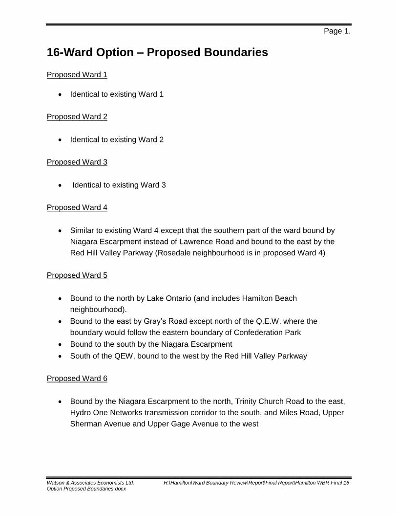
Page 1.
Watson & Associates Economists Ltd. H:\Hamilton\Ward Boundary Review\Report\Final Report\Hamilton WBR Final 16 Option Proposed Boundaries.docx
16-Ward Option – Proposed Boundaries
Proposed Ward 1
Identical to existing Ward 1
Proposed Ward 2
Identical to existing Ward 2
Proposed Ward 3
Identical to existing Ward 3
Proposed Ward 4
Similar to existing Ward 4 except that the southern part of the ward bound by
Niagara Escarpment instead of Lawrence Road and bound to the east by the
Red Hill Valley Parkway (Rosedale neighbourhood is in proposed Ward 4)
Proposed Ward 5
Bound to the north by Lake Ontario (and includes Hamilton Beach
neighbourhood).
Bound to the east by Gray’s Road except north of the Q.E.W. where the
boundary would follow the eastern boundary of Confederation Park
Bound to the south by the Niagara Escarpment
South of the QEW, bound to the west by the Red Hill Valley Parkway
Proposed Ward 6
Bound by the Niagara Escarpment to the north, Trinity Church Road to the east,
Hydro One Networks transmission corridor to the south, and Miles Road, Upper
Sherman Avenue and Upper Gage Avenue to the west
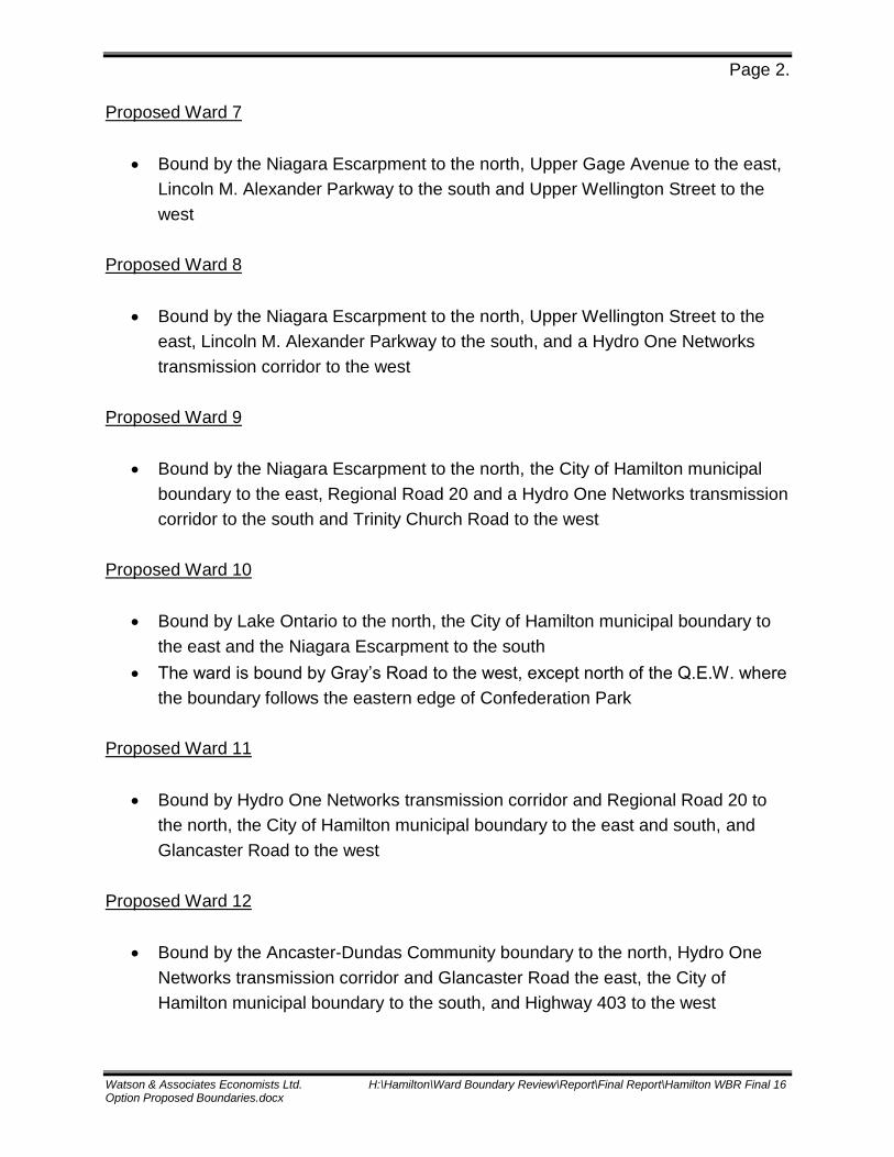
Page 2.
Watson & Associates Economists Ltd. H:\Hamilton\Ward Boundary Review\Report\Final Report\Hamilton WBR Final 16 Option Proposed Boundaries.docx
Proposed Ward 7
Bound by the Niagara Escarpment to the north, Upper Gage Avenue to the east,
Lincoln M. Alexander Parkway to the south and Upper Wellington Street to the
west
Proposed Ward 8
Bound by the Niagara Escarpment to the north, Upper Wellington Street to the
east, Lincoln M. Alexander Parkway to the south, and a Hydro One Networks
transmission corridor to the west
Proposed Ward 9
Bound by the Niagara Escarpment to the north, the City of Hamilton municipal
boundary to the east, Regional Road 20 and a Hydro One Networks transmission
corridor to the south and Trinity Church Road to the west
Proposed Ward 10
Bound by Lake Ontario to the north, the City of Hamilton municipal boundary to
the east and the Niagara Escarpment to the south
The ward is bound by Gray’s Road to the west, except north of the Q.E.W. where
the boundary follows the eastern edge of Confederation Park
Proposed Ward 11
Bound by Hydro One Networks transmission corridor and Regional Road 20 to
the north, the City of Hamilton municipal boundary to the east and south, and
Glancaster Road to the west
Proposed Ward 12
Bound by the Ancaster-Dundas Community boundary to the north, Hydro One
Networks transmission corridor and Glancaster Road the east, the City of
Hamilton municipal boundary to the south, and Highway 403 to the west

Page 3.
Watson & Associates Economists Ltd. H:\Hamilton\Ward Boundary Review\Report\Final Report\Hamilton WBR Final 16 Option Proposed Boundaries.docx
Proposed Ward 13
Bound by Highway 5, Rock Chapel Road and the Niagara Escarpment to the
north, the Dundas-Lower Hamilton Community boundary to the east, the
Ancaster-Dundas Community boundary to the south and Middletown Road to the
west
Proposed Ward 14
Bound by the City of Hamilton municipal boundary to the south, west and north
Bound to the east by Concession 7, Concession 6, Ofield Road, Moffat Road,
Highway 5, Middletown Road, and Highway 403
Proposed Ward 15
Bound by the City of Hamilton municipal boundary to the north and east, the
Niagara Escarpement, Rock Chapel Road and Highway 5 to the south, and
Ofield Road, Moffat Road, Concession 6 and Concession 7 to the west
Proposed Ward 16
Bound by the Lincoln M. Alexander Parkway to the north, Upper Sherman
Avenue and Miles Road to the east, and the Hydro One Networks transmission
corridor to the south and west

¬«2 ¬«3
¬«1¬«13
FENNELL AV
BARTON ST
MOHAWK RD
YORK RD
MAIN ST
BAY S
T
GAGE
AV
OTTA
WA ST
SCENI C DR
QUEE
N ST
SHER
MAN
AV
KENI
LWOR
TH AV
WENT
WOR
TH S
T
VICTO
RIA A
V
JOHN
ST
ABERDEEN AV
HIGHWAY NO. 5
SHERMAN ACCESS
GART
H ST
YORK BV
OSLER DRWE
ST 5T
H ST
WELL
INGT
ON S
T
OLDGUELPH RD
UPPE
R GA
GE AV
LAWRENCE RD
BURLINGTON ST
UPPE
R JA
MES
ST
COOTES DR
VALLEYRD
UPPE
R SH
ERMA
N AV
UPPE
R OT
TAWA
ST
PATTER
SON RD PLAINS RD
UPPE
R WE
LLIN
GTON
ST
JAME
S ST
UPPE
R WE
NTW
ORTH
ST
DUND
URN
ST
KING ST
WILSON ST
OLYM
PIC
DR
BE CKE TT DRCLAREMONT ACCESS
CONCESSION ST
UPPE
RPA
RADI
S ER D
INDUSTRIAL DR
SYDENHAMRD
CHARLTON AV
CONCESSION ST
KING ST
YORK
BV
COOTES DR
PLAINS RD
MAIN STCOOTES DR
PLAINS RD
JAME
S ST
YORK BV
KING ST
City of Hamilton16 Ward Option - Proposed Ward 1, 2 & 3
¯ 0 1.5 30.75 Km
Highway Ramp
HighwayMajor RoadRailways
Major Utility CorridorsNiagara EscarpmentLakes
Ward Boundaries with Ward #¬«3
££403

¬«5 ¬«10
¬«9
¬«11
¬«2 ¬«4¬«1BARTON ST
RYMAL RD
HIGHLAND RD
MAIN ST
RIDGE RD
HIGHWAY NO. 8
SOUTH SERVICE RD
FIFTH
RD
THIR
D RD
FIRST
RD
MUD ST
BEACH BV
SECO
ND R
D
MOHAWK RD
FENNELL AV
RED
HIL L
VALL
EYPY
GAGE
AV
NASH
RD
F IFTYRD
REGIONAL RD 20
SIXTH
RD
STONE CHURCH RD
NORTH SERVICE RD
MILL
EN R
D
GREE
N RD
OTTA
WA ST
GREEN MOUNTAIN RD
KING ST
NEBO
RD
PARK
DALE
AVBURLINGTON ST
GRAY
RD
TENT
H RD
SHER
MAN
AV
KENI
LWOR
TH AV
MCNE
ILLY R
D
WENT
WOR
TH S
T
WINO
NA R
D
VICTO
RIA A
V
EIGHT
H RD
UPPE
R CE
NTEN
NIAL
PYUPPE
R OT
TAWA
ST
ELEV
ENTH
RD
SHERMAN ACCESS
LINCOLN M. ALEXANDER PY
MILE
S RD
UPPE
RW
ENTW
O RTH
S T LAWRENCE RD
TWENTY RD
WOOD
WARD
AV
GRAY
S RD
NIN T
HRD
G LO V
E RR D
TAPL
EYTO
WN R
D
SEVE
NTH
RD
OLD MUD ST
LEW
IS RD
EAST
TOW
NLIN
E RD
CENTENNIAL PY
INDUSTRIAL DR
HIGHLAND RD
GLOV
ER R
D
FIRST
RD
ELEV
ENTH
RD
RED H
ILLVAL
LEYP
Y
FIFTY
RD
EIGHT
H RD
RIDGE RD
MUD ST
EIGHTH RD
KING ST
TENT
H RD
City of Hamilton16 Ward Option - Proposed Ward 4, 5, 9 &10
¯ 0 3.5 71.75 Km
Highway Ramp
HighwayMajor RoadRailways
Major Utility CorridorsNiagara EscarpmentLakes
Ward Boundaries with Ward #¬«3
££QEW
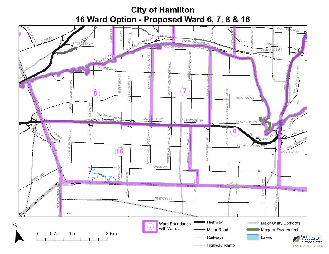
¬«8
¬«2¬«3
¬«7
¬«6
¬«16RYMAL RD
MOHAWK RD
TWENTY RD
FENNELL AV
LINCOLN M. ALEXANDER PY
NEBO
RD
GART
H ST
SCENIC DR
KING ST
RED HILL VA LLEY PY
UPPE
R JA
MES
ST
MILE
S RD
UPPE
R GA
GE AV
GARNER RD
GLOV
ER R
D
UPPE
R OT
TAWA
ST
ABERDEEN AV
BAY S
T
SHERMAN ACCESS MAIN ST
WEST
5TH
ST
UPPE
R WE
LLIN
GTON
ST
UPPE
R WE
NTW
ORTH
ST
LAWRENCE RD
QUEE
N ST
GLAN
CAST
ER R
D
LIMERIDGE RD
MOUN
T ALB
ION
R D
HIGHLAND RD
UPPE
R PA
RADI
SE R
D
UPPE
R SH
ERMA
N AV
COOTES DR
QUEENSTON RD
OTTA
WA ST
JAME
S ST
TRIN
ITY C
HURC
H RD
MUD ST
GAGE
AV
BE CKETT DR
KENI
LWOR
TH AV
STONE CHURCH RD
CLAREMONT ACCESS
CONCESSION ST
PARAMOUNT DR
UPPERHORNING RD
CHRI
STIE
ST
CHARLTON AV
UPPE
R WE
LLIN
GTON
ST
PARA
MOUNT DR
GART
H ST
KING ST
UPPE
ROT
T AW
A ST
MUD ST
LIMERIDGE RD LIMERIDGE RD
UPPE
R SH
ERMA
N AV
UPPE
R JA
MES
ST
STONE CHURCH RD
UPPE
R GA
GE AV
UPPE
R WE
NTW
ORTH
ST
UPPE
R PA
RADI
SE R
D
LIMERIDGE RD
RED
HILL
VALL
EYPY
CONCESSION ST
City of Hamilton16 Ward Option - Proposed Ward 6, 7, 8 & 16
¯ 0 1.5 30.75 Km
Highway Ramp
HighwayMajor RoadRailways
Major Utility CorridorsNiagara EscarpmentLakes
Ward Boundaries with Ward #¬«3

¬«4 ¬«5 ¬«10
¬«9
¬«11
RYMAL RD
KIRK RD
HALDIBROOK RD
GUYATT RD
AIRPORT RD
HALL RD
TWENTY RD
CHIPPEWA RD
GOLF CLUB RD
BINBROOK RD
HIGHLAND RD
NEBO
RD
UPPE
R JA
MES
STDICKENSON RD
REGIONAL RD 20
BELL RD
TYNE
SIDE
RD
MILE
S RD
TRIN
ITY C
HURC
H RD
GLAN
CAST
ER R
D
GLOV
ER R
D
LEEMING RD
HIGH
WAY N
O. 6
GART
H ST
R EG I
O NAL
RD56
WHITE CHURCH RD
HEND
ERSH
OT R
D
WOOD
BURN
RD
HARR
ISON
RD
ENGLISH CHURCH RD
BOOK RD
FLET
CHER
RD
GARNER RD
FIFTH
RD
FERR
IS RD
SIX THR D
TRIM
BLE
RD
BUTTER RD
SAWMILL RD
WEST
BROO
K RD
BLAC
KHEA
TH R
D
SINCLAIRVILLE RD
BERR
Y RD
CHRI
STIE
ST
FERR
IS RD
MILE
S RD
FLET
CHER
RD
WOOD
BURN
RD
REGI
ONAL
RD
56
HALL RD
WEST
BROO
K RD
TRIM
BLE
RD
BINBROOK RDWHITE CHURCH RD
WOOD
BURN
RD
MILE
S RD
WOOD
BURN
RD
TRIN
ITY C
HURC
H RD
HARR
ISON
RD
FLET
CHER
RD
MILE
S RD
GLAN
CAST
ER R
D
MILE
S RD
WHITE CHURCH RD
HEND
ERSH
OT R
D
NEBO
RD
T RIM
BLER
D
GOLF CLUB RD
HEND
ERSH
OT R
D
DICKENSON RD
City of Hamilton16 Ward Option - Proposed Ward 11
¯ 0 3 61.5 Km
Highway Ramp
HighwayMajor RoadRailways
Major Utility CorridorsNiagara EscarpmentLakes
Ward Boundaries with Ward #¬«3

¬«12
¬«11
¬«2 ¬«3
¬«6
¬«13
BOOK RD
GOVERNOR'S RD
WILSON ST
GARNER RD
BUTTER RD
RYMAL RD
MOHAWK RD
AIRPORT RD
TWENTY RD
UPPE
R JA
MES
ST
SAWMILL RD
CHIPPEWA RDTRINITY RD
CONCESSION 2
FENNELL AV
POWER LINE RD
CARLUKE RD
DICKENSON RD
ORKNEY RD
SHAVER RD
GART
H ST
LINCOLN M. ALEXANDER PY
FIDDLER'S GREEN RD
SCENIC DR
GLAN
CAST
ER R
D
FIELD RD
LEEMING RD
SOUTHCOTE RD
MILE
S RD
HIGHWAY NO. 52
WEIRS LN
WHITE CHURCH RD
HIGH
WAY N
O. 6
HIGHWAY NO. 5
MIDDLETOWN RD
ENGLISH CHURCH RD
MINERAL SPRINGS RD
BINKLEY RD
WEST
5TH
ST
JERSEYVILLE RD
FERR
IS RD
MAIN
ST
FERGUSON RD
HALDIBROOK RD
UPPE
R PA
RADI
SE R
DSLOTE RD
UPPE
R SH
ERMA
N AV
ALBERTON RD
SUNNYRIDGE RD
STONE CHURCH RD
DUNMARK RD
GOLF LINKS RD
WILSON
ST
WEST
5TH
ST
MILE
S RD
WILSON ST
MILE
S RDJERSEYVILLE RD
UPPE
R SH
ERMA
N AV
BUTTER RD
MILE
S RD
FIELD RD
ALBERTON RD
SHAVER RD
MOHAWK RD
WHITE CHURCH RD
SAWMILL RD
MILE
S RD
SHAVER RD
HIGHWAY NO. 52
SHAVER RD
GART
H ST
HIGHWAY NO. 52 GLAN
CAST
ER R
D
UPPE
R JA
MES
ST
JERSEYVILLE RD
City of Hamilton16 Ward Option - Proposed Ward 12
¯ 0 3.5 71.75 Km
Highway Ramp
HighwayMajor RoadRailways
Major Utility CorridorsNiagara EscarpmentLakes
Ward Boundaries with Ward #¬«3
££6££403

¬«14
¬«11
¬«9
¬«14
¬«10
¬«5¬«4
¬«1¬«3
¬«8
BROCK RD
BOOK RD
GORE RDHIGHWAY NO. 6
GOVERNOR'S RD
CONCESSION 5
HIGHWAY NO. 8
CONCESSION 2
RYMAL RD
MOHAWK RD
WILSON ST
GARNER RD
SAFARI RD
BARTON ST
TWENTY RD
AIRPORT RD
REGIONAL RD NO. 97
BUTTER RDKIRKWALL RD
CONCESSION 4
POWER LINE RD
MILBUROUGH LI
WESTOVER RD
FENNELL AV
LYNDEN RDHIGHWAY NO. 5
CENTRE RD
CONCESSION 8
SAWMILL RD
CHIPPEWA RD
CONCESSION 6
SAGER RD
TRINITY RD
MIDDLETOWN RD
HALDIBROOK RDSHEFFIELD RD
LINCOLN M. ALEXANDER PY
BEACH BV
CARLUKE RD
BAY ST
CONCESSION 10
GARTH ST
PARK
SIDE D
R
BURLINGTON ST
CAMP
BELL
VILLE
RD
MILES RD
OTTAWA ST
SCENIC DR
WEIR RD
COOPER RD
MAIN ST
INDIAN
TL
MOUN
TSBE
RG RD
FIELD RD
LEEMING RD
WEIRS LN
SOUTHCOTE RD
MOXLEY RDOFIELD RD
HIGHWAY NO. 52
SETTLERS RD
SYDENHAM RD
KENILWORTH AV
VALENS RD
JOHN STWYATT RD
FREELTON RD
ROBSON RD
CARL
ISLE R
D
INKSETTER RD
CONC
ESSIO
N 14
BINKLEY RDYORK BV
OSLER DR
JERSEYVILLE RD
EDGEWOOD RD
KERNS RD
FERGUSON RD
MILL ST
VALLEY RD
PLAINS RD
ALBERTON RD
STONE CHURCH RD
GOLF LINKS RD
HIGHWAY NO. 5 CONCESSION 4
MAIN ST
SHEFFIELD RD
CONCESSION 10
WILS
ON ST
VALENS RD
SAWMILL RD
MILES RD
MOHAWK RD
MILES RD
POWER LINE RD
CENTRE RD CENTRE RD
MILBUROUGH LI
SAFARI RD
BUTTER RD
CONC
ESSIO
N 8
City of Hamilton16 Ward Option - Proposed Ward 14
¯ 0 8 164 Km
Highway Ramp
HighwayMajor RoadRailways
Major Utility CorridorsNiagara EscarpmentLakes
Ward Boundaries with Ward #¬«3

¬«11
¬«9
¬«10
¬«5
¬«13
¬«1
¬«15
BROCK RD
HIGHWAY NO. 6
RYMAL RD
CONCESSION 5
MOHAWK RD
BARTON ST
TWENTY RD
SAFARI RD
HIGHWAY NO. 8 GOVERNOR'S RD
WESTOVER RD
FENNELL AV
CONCESSION 4
CENTRE RD
WILSONST
CONCESSION 8
NEBO RD
CONCESSION 6
BEACH BV
YORK R
D
MIDDLETOWN RD
REGIONAL RD NO. 97
CONCESSION 2
LINCOLN M. ALEXANDER PY
HIGHWAY NO. 5
KIRKWALL RD
VALENS RD
GORE RD
BAY ST
GAGE AV
NASH RD
GARTH ST
MILBUROUGH LI
LYNDEN RD
MILES RD
PARK
SIDE D
R
GARNER RD
OTTAWA ST
SCENI C DR
CAMP
BELL
VILLE
RD
PARKDALE AV
MAIN ST
MOUN
TSBE
RG RD
GLOVER RD
LENNON RD
WEIRS LN
MOXLEY RD
QUEEN ST
OFIELD RD KING ST
SODOM RD
KENILWORTH AV
HARVEST RD
TRINITY CHURCH RD
JOHN ST
CONC
ESSIO
N7
HIGHLAND RD
ORKNEY RD
WYATT RD
MILLGROVE SIDEROAD
MINERAL SPRINGS RD
UPPER OTTAWA ST
FREELTON RD
MUD ST
DICKENSON RD
ROBSON RD
CARL
ISLE R
D
GARDEN LN
SHERMAN ACCESS
INKSETTERRD
CONC
ESSIO
N 14
CONC
ESSIO
N 11
YORK BV
WEST 5THST
CONC
ESSIO
N10
OSLER DR
OLD GUELPH RD
EDGEWOOD RD
KERNS RD
WOODWARD AV
BURLINGTON ST
MOUN
T ALB
ION
RD
UPPER PARADISE RD
SNAKE RD
CONC
ESSIO
N 12
PROG
REST
ON RD
KING RD
STONE CHURCH RD
GOLF LINKS RD
VALENS RD
CONC
ESSIO
N 8
SAFARI RD
CENTRE RD
KING ST
VALENS RD
WESTOVER RD
HIGHWAY NO. 8
CONCESSION 4
MOHAWK RD
CONCESSION 6
MUD STHIGHWAY NO. 5
DICKENSON RD
CARL
ISLE R
DBAY ST
CONCESSION 10
GARTH ST
CENTRE RD
MILBUROUGH LI
City of Hamilton16 Ward Option - Proposed Ward 13 & 15
¯ 0 5 102.5 Km
Highway Ramp
HighwayMajor RoadRailways
Major Utility CorridorsNiagara EscarpmentLakes
Ward Boundaries with Ward #¬«3
Top Related