


Languages
Pages
Legal


Chapter IV
North East India: Social, Political, Economic andSecurity Perspectives
North East India: Social, Political, Economic and Security Perspectives156
Chapter IV
North East India: Social, Political, Economic and Security Perspectives
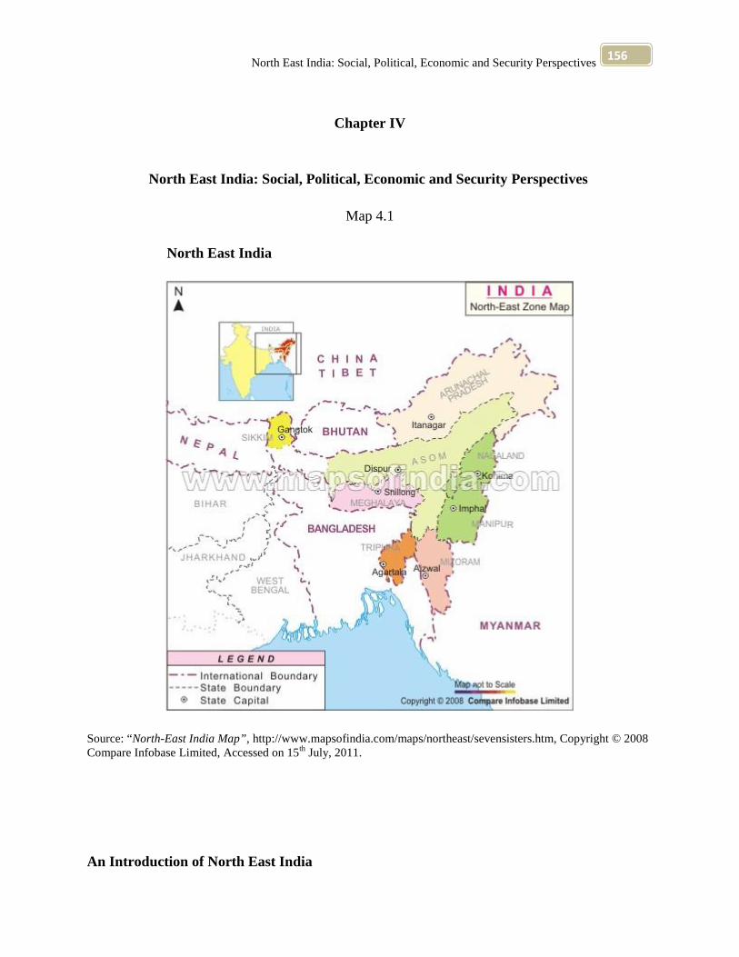
Map 4.1
North East India
Source: “North-East India Map”, http://www.mapsofindia.com/maps/northeast/sevensisters.htm, Copyright © 2008Compare Infobase Limited, Accessed on 15th July, 2011.
An Introduction of North East India

North East India: Social, Political, Economic and Security Perspectives157
North- East India is essentially the creation of the British. Before 1947, the whole of North- East
India, excluding Manipur and Tripura was Assam. However, immediately after independence
fissiparous forces lead to the dismemberment of greater Assam resulting in the formation of
seven North- Eastern sisters, namely Arunachal Pradesh, Assam, Manipur, Meghalaya, Mizoram,
Nagaland and Tripura have been dealt with. Geographically, this region is almost isolated from
the rest of India. North- East is strategically important and is girdled by Tibet, Bhutan, China,
Myanmar (formerly Burma) and Bangladesh. It is linked to the rest of the country by a narrow
corridor in West Bengal. 1
The North East region of India occupies strategic geopolitical situation due to its international
boundaries with Bangladesh, Bhutan, China, Myanmar and Nepal. The region earlier comprised
the states of Arunachal Pradesh, Assam, Manipur, Meghalaya, Mizoram, Nagaland, Tripura,
popularly known as the ‘Seven Sisters.’ Recently, the State of Sikkim also come under the
umbrella of this region owing to its proximity to the area and somewhat similar type of
developmental and other problems.2
The term “North east Frontier” connotes with reference to present day, British India something
entirely different from what it did with regard to the Mughal Empire of the sixteenth and
seventeenth centuries. While it is now applicable to the hilly region lying to the north and east of
Sadiya, which commands the route to China, it meant in the Mughal age the Mongoloid states of
Koch Bihar, Kamrup and Assam, which bordered serially on the province of Bengal in the north-
east. 3
1 “Sikkim and the Seven Sisters” (1996) Encyclopaedia of India and Her States” Volume 9, ed. Verinder Groverand Ranjan Arora, Published by Deep and Deep Publications, F- 159, Rajouri Gander, New Delhi- 110027, pp 684,686.2 “Preface” (2005), Discovery of North East India, Volume 3, ed. S.K. Sharma and Usha Sharma, MittalPublications, A- 110, Mohan Garden, New Delhi 110059 (India).3 Sudhindra Nath Bhattacharya (2005) “The North- East Frontier”, Discovery of North East India, Volume 1, ed.S.K. Sharma and Usha Sharma, Mittal Publications, , A- 110, Mohan Garden New Delhi 110059 (India), p 1.

North East India: Social, Political, Economic and Security Perspectives158
The region covered by the principalities is in much strange shape- great length by very little
breath, and like it again, it may be said to be watered by one life-giving river (the Brahmaputra).
The greater part of the country is shut in between high and inaccessible hills, which girdle it in
three sides- north, south and east, while on the fourth, is a river, the Karatoya. The only point of
contact with the outside world is on the west, and particularly south- west, and it is here that the
Mughal Sarkar of Ghoraghat touched the fringe of Koch domain which was naturally the first to
come within the pole of Imperial foreign policy. 4
North East India is full of hills, streams and rivers. The hills are covered with dense forests
because of the heavy rainfall. In some places, the ridges rise one after another. The valleys are
deep, narrow and steepsided and the streams are deepening and cutting the valleys. As a
consequence, communications between one hill and another is practically impossible. The
rugged physiographic condition of this region render the tribes to live in splendid isolation. The
isolated conditions of the different tribes induces them to demand political independence. The
Mizos and the Nagas demanded independence because they were not touched profoundly by
administration. The Khasi and the Garos did not demand independence because they were in
close contact with the people of the plains and understood the benefits, cultural, political and
economic, resulting from such contacts.
North East India is strategically important. It has natural frontiers on three sides and a political
boundary on the fourth. It has common frontiers with four political communities, China in the
North, Bhutan in the West, Bangladesh in the East and Myanmar (formerly Burma) in the South.
No other part of India occupies such a strategic position as the North East.5
Long before the advent of the British, the indigenous people in the hills of north- east India had
organized themselves under the political systems of their own which had been the natural
outcome of their social evolution. Two distinctly different types of system of governance had
4 Ibid. p 1.5 V. Venkata Rao (1996) “North East India: Problems and Prospects,” Encyclopaedia of India and Her States,”Volume 9, ed. Verinder Grover and Ranjana Arora, Published by Deep and Deep Publications, F- 159, RajouriGander, New Delhi- 110027, pp 3-4.
North East India: Social, Political, Economic and Security Perspectives159
been evolved in the hills, i.e., democratic system in the clan- based village societies controlled by
the village councils and village headmen, had autocratic system of chieftainship controlled by the
clan or village chiefs. The extent of power and authority of these traditional political institutions
in relation to their people used to vary from tribe to tribe. While in certain communities these
traditional institutions were well- organized and well- structured and even, in few cases, they led
the formation of miniature states. In some communities these institutions were loosely organized
without any central authority. 6
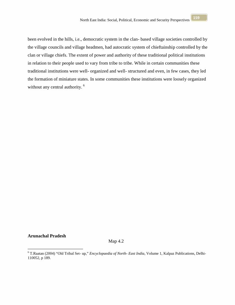
Arunachal PradeshMap 4.2
6 T.Raatan (2004) “Old Tribal Set- up,” Encyclopaedia of North- East India, Volume 1, Kalpaz Publications, Delhi-110052, p 189.

North East India: Social, Political, Economic and Security Perspectives160
Source: “Map of Arunachal Pradesh, ” http://www.arunachalpradesh.nic.in/Pic-htms/mapofarunachal.htm,Accessed on 16th July, 2011.
History of Arunachal Pradesh goes back to hundreds of years into mists of tradition and myth.
Local tradition regards the country around Sadiya as the ancient Vidarbha. Ancient Puranas have
North East India: Social, Political, Economic and Security Perspectives161
many references to the region. Recorded history of Arunachal Pradesh can be traced only when
Ahom kings began to rule Assam in the 16th century. The British took possession of Assam in
1838. British government had brought Arunachal Pradesh also under their administrative control.
After independence, it was a part of North East Frontier Agency, and later, made a union
territory. On 20th February, 1987 Arunachal Pradesh is skirted by Bhutan in west, Tibet and
China in north and north- east, Burma in east and Assam in south. It consists of the sub-
mountains and mountainous ranges sloping to the plains of Assam. It is the largest state area-
wise in north- east region. 7
The total area of Arunachal Pradesh is 83,743 sq km. 8
Arunachal Pradesh is the land of 22 distinct tribes speaking as many languages. This culturally
rich State of India is surrounded by Bhutan to the west, China (Tibet) to the north, (formerly
Burma) Myanmar to the east, Nagaland and Assam to the south. Till 1962, neither the natives
thought they were part of any country nor the Indians viewed them as Indians (many Indians still
think so). It was after the Chinese aggression that the Government of India woke up to the reality
that there also existed a part of India called North East Frontier Agency (present Arunachal
Pradesh).
The geography, history, sociology, morality and philosophy taught to the natives are those of the
mainland India, not of Arunachal Pradesh. As a result they are being culturally displaced. Not
only that, the students of the mainland are not taught anything about Arunachal Pradesh and its
people. That is why there exists a big communication gap between the natives and the
mainstream people. Even the official media like Doordashan hardly gives coverage to Arunachal
Pradesh and its people. For that matter, faces from tribal States of North East are rare sights on
the TV screen.
7 Tado Karlo (1996) “Arunachal: Plight of the Natives,” Encyclopaedia of India and Her States,” Volume 9, ed.Verinder Grove and Ranjana Arora, Published by Deep and Deep Publications, F- 159, Rajouri Gander, New Delhi-110027, pp 95, 107-109.8 Oxford School Atlas 32nd Edition (2010), Oxford University Press, p 25.
North East India: Social, Political, Economic and Security Perspectives162
The motto of the colonizers of the past God, Glory and Gold, finds its follower ever today. What
one sees in Arunachal Pradesh is cultural imperialism. Also, the presence of huge number of
Indian Army, along the 1030 km long border with China, puts the natives to submission. In fact,
most of the fertile valleys in this highly mountainous State have been occupied by the Army.9
The concept of land ownership in the region under study may, broadly be considered under three
heads, namely the individual, the clan and the village common land. As ownership of land differs
from tribe to tribe, the same system varies between the tribes practicing shifting cultivation only
and the other tribes having continuous and permanent cultivation. The land under individual
ownership comprises cultivated land such as irrigated rice fields, fields for dry crops, kitchen
gardens, plots for crops like maize, vegetables, fruit trees, bamboo groves, pine other useful trees
and homestead site. The land such as meadows close to village, commonly used as pasture as
well as burial ground and the tracts of forests come under clan ownership.10
The Practice of Religion in Arunachal Pradesh
The Khamtis are a Buddhist tribe living mainly in the Lohit district of Arunachal Pradesh.
The Khamtis are pure Buddhists. They are process the Theravada (Khamti, to- ni) in fact,
brought their Buddhism from Myanmar (formerly Burma).
The Khamti priests (Khamti, chow- mun) are men of great importance, and their influence is
greater even than that of the chiefs. No undertaking is commenced without first consulting them,
and by pretended divinations they select and announce an auspicious day. They are also the
school- masters, every free- born Khamti youth being compelled to attend school in the temples,
where he learns to read and write his own language.
9 Ibid. pp 95, 107-10910 T.Raatan (2004) “Ownership of Lands,” Encyclopaedia of North- East India, Volume 2, Kalpaz Publications,Delhi- 110052.
North East India: Social, Political, Economic and Security Perspectives163
It is the responsibility of the villagers to provide food to the bhikkhu and samaneras, who may
also receive gifts of the barest necessities, and accept invitations to meals. 11
Agriculture is the mainstay of the people, who by and large, follow a slash and burn method of
shifting cultivation called jhum practiced on rain- bed slopes of forest hills and dales. Rice is the
principal crop and other important crops are maize, millet, wheat, pulses, potato, sugarcane and
oilseeds. Ecological conditions in Arunachal Pradesh are congenial for the growth of
horticulture. Besides, pineapple, orange, lemon, lichi, papaya, banana, guava temperate fruits
such as apple, plum, peas, cherries, walnut, almond etc., are grown in above 1,400 horticulture
gardens. 12
Endowed with abundant forest, mineral and hydel power resources, Arunachal Pradesh was a
high industrial potential. Limestone also occurs at Hunli in Dibang Valley distinct and Menga in
Upper Subansiri District. These apart, occurrences of graphite, quartzite, kyanite, mica, iron and
copper ores are also reported. Remarkable progress has been achieved in the field of cottage
industries, of which weaving, basketry and carpetmaking merit particular mention. Small scale
industries numbering 1,957 in 1990-91 comprise saw, rice and oil mills, fruit preservation, soap
and candle manufacturing units, steel fabrication, wood works and so on. 13
An Idu village is usually a collection of homestead, each consisting of a single family of parents
and children as the smallest unit. The Idus practice polygamy and each wife has a separate
apartment within the same homestead. Sometimes two or more lineally related kinsmen, their
wives and children occupy a single homestead, and are jointly subject to the same authority. A
domestic group may also include other persons related to the family, such as widows, orphans
and infirm persons. The attitude towards the father, the fathers’ brothers, and the grandfather is
11 Bhikshu Kondinya (1996) “Role of Religion in Khamti Society,” Encyclopaedia of India and Her States,”Volume 9, ed. Verinder Grover and Ranjana Arora, Published by Deep and Deep Publications, F- 159, RajouriGander, New Delhi- 110027, pp 139- 140.12 “Agriculture” (1996) Encyclopaedia of India and Her States Volume 9, ed. Verinder Grover and Ranjan Arora,Published by Deep and Deep Publications, F- 159, Rajouri Gander, New Delhi- 110027, p 96.13 “Minerals and Industries” (1996) Encyclopaedia of India and Her States” Volume 9, ed. Verinder Grover andRanjan Arora, Published by Deep and Deep Publications, F- 159, Rajouri Gander, New Delhi- 110027, p 96.

North East India: Social, Political, Economic and Security Perspectives164
one of respect, and usually the father is considered to be the authoritative head, who has an
effective say in all matters that concern the family. The mother’s brother, is treated with a degree
of intimacy and affection which would not be shown to the father or lies brothers. 14
Kinship, social and economic ties hold together the members of the homestead. In ordinary
activities such as fishing, collection of food, clearing of the jungle and cultivation, they act as a
single unit. Properties such as land, livestock, and foodstuff, house and forest trees are held
jointly, by the family. But, personal effects such as ornaments, clothing, cash and household and
occupational equipment may belong to the individual separately. 15
The political transformation has an obvious impact on the socio- economic life of the people of
Arunachal Pradesh. A policy of alienation inspired the British regime to keep the hill areas
scheduled and away from the mainstream of the culture and social life of the country. This had
adversely affected the process of national integration. But the people of Arunachal are now on
the move. They are now expanding- materially, culturally and spiritually. The hills do not
circumscribe their mental horizon any more. Arunachal is undergoing a silent transformation. 16
At the time of Independence, Arunachal possessed no development whatsoever. There was
hardly any network of communications and welfare institutions. The British administration had
confined itself to the concept of loose administrative control by touring the major trade routes
upto the international frontier. In the hinterland, large tracts of territory remained unexplored,
unmapped and uncensused. In these areas many villages have been never located or visited and
there was even doubt regarding the course of major river system through the territory. 17
14 Tapan Kumar M. Barua (2005) “Social Life, “Discovery of North- East India,” Volume 2, ed. S.K. Sharma andUsha Sharma, Mittal Publications, A- 110, Mohan Garden, New Delhi 110059 (India) p 165.15 Ibid.16 “Arunachal’s Silent Revolution” (2001), Encyclopaedia of North –East India, Volume 1, ed. H.M. Bareh, MittalPublications, New Delhi- 110059 (India), p 112.17 Ibid, p 113.
North East India: Social, Political, Economic and Security Perspectives165
The Bill in its amended form known as the “Arunachal Freedom of Religious Faith Bill, 1978”
was passed by the Territorial Assembly and the President gave his assent, thereby giving it the
status of an Act. This indeed was a singular triumph for the people of Arunachal Pradesh. 18
Assam
18 Ibid, p 121.

North East India: Social, Political, Economic and Security Perspectives166
Map 4.3
Source: “Assam (Asom) District Map, Maps of Assam (Asom),”http://www.mapsofindia.com/maps/assam/assam-district.htm, Accessed on 13th June, 2012

North East India: Social, Political, Economic and Security Perspectives167
The word Assam is derived from Sanskrit asom meaning peerless, judged by her exquisite
natural beauty, cultural richness and human wealth. Assam has a rich legacy of culture and
civilization behind her. Being the homeland of different races of men: Austric, Mongolian,
Dravidian and Aryan that can to dwell in her hills and valleys at different times, since remote
antiquity, she has developed a composite culture of variegated colour. 19 The total area of Assam
is 78,438 sq km.20
The issue of the Asamiya nationality vis-a-vis the Bengalis in Assam has remained
controversial, ever since the arrival of the Bengali baboos in the wake of the annexation and
consolidation of the British control in Assam in 1826. However, this does not mean that Assam
had no connection at all with Bengal. Geographically, Assam’s connection with the rest of Indian
sub- continent has ever been through Bengal. Being a neighbor, Assam and Bengal have had
social, cultural, economic, diplomatic and political connections since beginning of human
civilization in that region of the sub- continent. Many of the present day Asamiya caste- Hindu
families came originally from Bengal during the later Ahom days. 21
Sociologically speaking, the Bengalis became a reference group of the Asamiyas who were
looking for upward social mobility within the emerging social hierarchy in British Assam. Many
of the Bengali sweetmeats, eating habits, dress pattern, manners, rituals and behavior found
acceptance among them. Some of them even talk proudly in Bengali, read Bengali papers and
literature.22
During the century for which Assam has been under British rule and enjoyed the blessings of a
settled Government, its material prosperity increased rapidly. Its trade has grown, and its exports
of mustard seed, potatoes (introduced in the Khasi hills by David Scott), silk and other local
produce have increased greatly, both in quantity and value. A large part of the lime used in
19 “Assam” (1996) Encyclopaedia of India and Her States” Volume 9, ed. Verinder Grover and Ranjan Arora,Published by Deep and Deep Publications, F- 159, Rajouri Gander, New Delhi- 110027, p 177.20 Ibid, p 25.21 T.Raatan (2004) “Identity Crisis,” Encyclopaedia of North- East India, Kalpaz Publications, Delhi- 110052, p 47.22 Ibid, p 50.
North East India: Social, Political, Economic and Security Perspectives168
Bengal in supplied from the quarries on the southern face of the Khasi hills. Coal has been
discovered and work in various parts especially in the neighbourhood of Makum in the
Lakhumpur district; and mineral has been found at Digboi in the same district, where wells have
been sunk for its extraction. But, by far the most important factor in the growing prosperity and
commercial importance of the province has been the remarkable expansion of the tea industry. 23
The national struggle for freedom is a long story to recount here. In 1921, the whole country
including Assam responded to the call of Mahatma Gandhi and played a glorious part in the fight
for our freedom. Assam’s contribution was in no way less. Bapuji visited Assam and called it
lovely Assam and also highly praised its people for their heroism and adherence to the ideal of
self reliance. India became free on 15th August, 1947. But, independence brought a large number
of problems in its wake. The country was partitioned and this brought Assam to the fore. Assam
became the real frontier of strategic importance. 24
Assam occupies a very important position in the map of India, surrounded as it is by different
foreign countries namely Bhutan and Bangladesh, and people by various races and tribes
speaking different languages and dialects and having distinct cultures of their own. 25
Assam is not only rich in her cultural heritage but also rich, possibly the richest state, in India in
so far as natural resources are concerned. The flora and fauna, forest and mineral wealth, the
colourful way of life. They are full of all species of herbs, plants and tree known to botanical
experts. 26
The wild life of Assam has drawn the attention of the lovers of animals, not only of our country
but of all parts of the globe. In the famous sanctuaries like the Kaziranga sanctuary one can find
23 Edward Gait (2005) “Growth of the Tea Industry, “Discovery of North- East India,” Volume 5, ed. S.K. Sharmaand Usha Sharma, Mittal Publications, A- 110, Mohan Garden, New Delhi 110059 (India), p 39.24 Bharatchandra Pathakra (2005) “Assam- Its Past and Future,” Discovery of North- East India, Volume 4, ed. S.K.Sharma and Usha Sharma, Mittal Publications, A- 110, Mohan Garden, New Delhi 110059 (India), p 340.25 Ibid. pp 340- 34126 Ibid, p 341.
North East India: Social, Political, Economic and Security Perspectives169
one-horned rhino, wild buffalo, elephant, bear and different kinds of deer. The State offers ample
scopes for establishment of various important industries like cement factories, paper mills, sugar
mills, jute mill etc. Although very rich in raw materials, Assam is still lagging behind other sister
states of the union, industrially. 27
Ever since the British occupation, there had been a considerable flow of non- Assamese Indians
into Assam from other parts of India, particularly provinces in the neighbourhood of Assam.
With the arrival of the British, the old Assamese system of government was replaced and its
functions disappeared from public life. In order to run the new administration, clerks, officers
and other servants familiar with the system of Company administration were brought from
outside the province. Moreover, a certain number of other people also came within this flow to
fill the various demands of economic growth. The Assamese people like most other traditional
societies were agriculturists and looked down upon wage labour i.e., working for others. 28
The slow penetration into Assam of the immigrants from Bengal. Obviously, the virgin and
fertile soil of Assam had attracted a large number of immigrants .They came to Assam with their
families and began to increase the permanent population of Assam. Thus, the immigration
assumed alarming proportions. 29
The second aspect of the immigrant population in Assam was the tension between the Assamese
and Bengalis. The Assamese- Bengali question has been of special importance to the people of
Assam.30
The British Government made frequent change of the boundary of Assam according to its
convenience. Just after its occupation Assam was brought under the administrative jurisdiction of
Bengal. Later on although it was made a separate Governor’s Province in 1921, two districts of
27 Ibid. pp 340- 34128 Girin Phukon (1996) “Politics of Influx in Assam: A Pre- Independence Perspective,” Encyclopaedia of Indiaand Her States,” Volume 9, ed. Verinder Grover and Ranjana Arora, Published by Deep and Deep Publications, F-159, Rajouri Gander, New Delhi- 110027, p 228.29 Ibid, p 229.30 Ibid, p 231.
North East India: Social, Political, Economic and Security Perspectives170
Bengal, namely Sylhet and Cachar, were tagged on to Assam. These two districts had for
centuries been integral parts of Bengal. Their history had been the history of Bengal, their
language is Bengali, their ways and their outlook was almost the same as those of Bengal. Assam
proper, on the other hand, comprised the Brahmaputra Valley and was a self- contained and
independent kingdom. The dominant people in this variegated group were the Assamese
speaking people. They were not all of the same racial stock, but due to close association and a
common life and language they developed a culture of their own, markedly different, as they saw
it, from the temperament and character of their Bengali neighbour. Their history was a history of
isolation from Bengal and Mughal India, which they zealously guarded by the force of arms. As
a result, there emerged a problem of cultural and political integration between these two
streams.. In a society having socio- cultural differences, the creation of a unified political
authority is not enough to forge a single and durable political entity. People cannot be held
together unless they are made to cherish certain common political values and attitudes. It is
obvious that the role of historical antecedents, both political and cultural, is of crucial importance
for the purpose of harmonious blending of the heterogeneous elements. Such a harmony is
crucial for the purpose of political integration and political development. In Assam, however,
such mobilization and tradition had not yet been possible. 31
The majority of the Bengalis in Assam were, however, immigrants from East Bengal. In short,
time the Bengali- speaking people emerged as the second largest group in the Assam Valley. 32
Manipur
Map 4.4
31 Ibid, pp 231- 232.32 Ibid, p 232.

North East India: Social, Political, Economic and Security Perspectives171
Source: ”Manipur, Manipur Map, ”http://www.mapsofindia.com/maps/manipur/manipur.htm, Accessed on 29th
May, 2012
It is commonly known that an adventurer named Pakhangba ascended the throne of the seven
main principalities and founded a dynasty which ruled Manipur till 1949. The King named Loi
Yamba in 1074 A.D. consolidated the kingdom to a great extent. In the later years, Kabaws (who

North East India: Social, Political, Economic and Security Perspectives172
lived at Indo- Burma border) tried to annex the south eastern part of Manipur Valley which was
foiled by the King Khumomba. By 1470 Kabaw valley was annexed to Manipur. By 1542
Manipur dominions were further extended. There was a battle with the Chinese which the
Manipuris singly defeated them. 33
In the next 200 years, Manipur saw a steady prosperous time. In 1762, the Manipur king
concluded a treaty with the British to ward off the growing menace of the Burmese. It is well-
known that Burmese successes in Manipur, Assam and other places led to war between the
Burmese and the British lasting seven years. The treaty of Yandaboo in 1826 ended the war but
failed to solve the problem of Manipuris. The British Government kept Manipur as a native state
after much deliberations. After integration with the Indian Union in 1949, the problem of
Manipur did not end as it was made a Part ‘C’ state. Central leadership was against its merger in
Assam was considered by the Reorganization Commission. Hence, it became a Union Territory
under the State Reorganization Act 1956. At the growing dissent of the people, Manipur was
made of full-fledged state of the Union in 1972. Manipur is bounded by upper Myanmar
(formerly Burma) on east, the Chin Hills of Myanmar on south- east, Nagaland on north, Assam
on west and Mizoram on south and south- west. 34
The total area of Manipur is 22,327 sq km. 35
Manipur by virtue of its geographical position was in between the two called the Aryan culture
and Mongolian. Although in physical features and certain traditional practices people appear to
be more akin to the Mongolian camp, the basic principles mentioned in the old scriptures of the
Manipuris are much nearer to the Vedic religion than to the Mongolian currents of thought and
religion. That is to say Manipuri cultures forms part and parcel of the wide Vedic civilization. 36
33 “Manipur” (1996) Encyclopaedia of India and Her States Volume 9, ed. Verinder Grover and Ranjan Arora,Published by Deep and Deep Publications, F- 159, Rajouri Gander, New Delhi- 110027, p 339.34 Ibid. p 339.35 Ibid, p 25.
36 T.Raatan (2004) “Manipuri Culture Derived from Vedic Civilisation,” Encyclopaedia of North- East India,Volume 2, Kalpaz Publications, Delhi- 110052, p 134.
North East India: Social, Political, Economic and Security Perspectives173
Manipur has about 350 km long international border with Myanmar (formerly Burma) in the east
and southeast. It is surrounded by Nagaland, Mizoram and Assam in the north, south and west
respectively. Manipur came under the British rule as a princely State in 1891. It merged with
Indian union on 15th October, 1949. 37
Since most parts of the border with Myanmar are ‘open’, inhabitants in the interior areas
clandestinely and frequently traverse the borderline at different points. In fact, most of the
dwellers on both side of the border belong to the same tribe. Mostly Kukis and Nagas have been
found settling at these places with different nationalities. The tribal’s at the border in India are
allowed free passage to the other side of the other side of the border to meet their relatives.38
The Meitei insurgents hold the entire 1,800 square kilometer lush valley where most of
Manipur’s Vaishnavite Hindu population is concentrated and the state administration to ransom.
Policemen and men of the paramilitary forces like the Border Security Forces and the Central
Reserve Police Force have been the main target of the militants and their morale is at lowest ebb.39
A small, but determined, band of Manipuri Meitei radicals masquerading under the banner of the
secessionist “Peoples’ Liberation Army” (PLA), led by Lhasa- trained Nameirakpam Bisheswar,
ha been striking terror in the hearts of the peace- loving citizens with impunity. 40
The young generation which is passing out from schools and colleges everyday does not find
suitable employment avenues in the swelling. Graduates are already employed in the state police
as ordinary constables. With the expansion of educational facilities the unemployment problem
is likely to aggravate further in the coming years. It is these angry unemployed youngmen who
37 “Turbulent History of Manipur” (2001), Encyclopaedia of North –East India, Volume 3, ed. H.M. Bareh, MittalPublications, New Delhi- 110059 (India), p 42.38 Ibid. p 42.39 Ibid, p 67.40 “Turmoil in Manipur” (2001), Encyclopaedia of North –East India, Volume 3, ed. H.M. Bareh, MittalPublications, New Delhi- 110059 (India), pp 67, 83- 84

North East India: Social, Political, Economic and Security Perspectives174
are taking to undesirable methods for satisfying their aspirations and form the nucleus of the
rebel hardcore. 41
The growing pressure on land, the increasing competition for white- collared jobs, the growing
aspirations of the Meiteis, and the acquisition of power apparatus to change the ethnic division of
labour have united the “sons of the soil” to launch a virulent campaign to drive out the
“Mayangs” or non- Manipuris from Manipur. Simultaneously, the Meitei undergrounds have
sought to establish rapport with the Naga and Mizo insurgents by trying to project their
movement as a part of a-pan- Mongoloid drive for self assertion as well as trying to whip up a
popular agitation for atavistic revival of tribalism. Significantly, a senior Minister of the former
Shaiza cabinet, had sometime back presided over a public meeting where the Hindu scripture
like Geeta and Mahabharata were consigned to flames. 42
The hill areas of the state are endowed with rich natural resources- swift- flowing rivers and
fertile soils, rich vegetal cover, precious minerals and over and above a hard working, healthy,
strong and stout people, providing rich human resource base for economic development. But,
major part of the Manipur hills remains economically depressed and underdeveloped for poor
infrastructural facilities and unplanned utilization of natural resources. The gradual depletion of
the natural resources has brought miseries to the hill people and their ecosystem. Therefore, there
is an urgent need for proper attention to scientific management of natural resources, so that an
ecological balance can be maintained for the development of the hill tracts of the state. 43
Soil erosion is a serious menace in the hills areas of the state, which is the result of intense
jhuming and indiscriminate cutting and burning of forests. Without proper soil conservation
measures, such as contour bonding, terracing and protective afforestation, it will be difficult to
maintain the ecological balance in this part of the country. 44
41 Ibid, p 83.42 Ibid, p 84.43 “Economic Development” (2001), Encyclopaedia of North –East India, Volume 3, ed. H.M. Bareh, MittalPublications, New Delhi- 110059 (India), p 108.44 Ibid, p 110.
North East India: Social, Political, Economic and Security Perspectives175
Forests provide firewood, charcoal, roundwood and timber. Besides, fuel, they supply structural
timber for public use, matchwood, bamboos, canes, turpentine and resin, gums, oils, fibres,
honey, wax, thatching grasses and medicinal herbs. Many of them are used in various industries
and some are exported. Dalchini used in spices, and Agar cane, with proper marketing facilities,
earn a lot of foreign exchange besides their earn a lot of foreign exchange besides their extensive
use in the domestic market. 45
The forest-clad hills have a rich variety of wildlife. Himalayan black bear and the common
Indian sloth bear are found in the northern hills. The wild pig is common throughout the region.
Several species of porcupine, moles, rats, and mice are found in large numbers, particularly in
the Tamenglong district. 46
The main profession of the population is agriculture. Weaving, fishing and other cottage
industries are the main supplement. Employment in the Government and semi- Government
establishments and institutions. The main profession of a substantial section of the population in
and around Imphal is weaving. 47
The villages on the bank of Loktak have the mixed profession of agriculture and fishing. The
cottage industries, viz., carpentry, blacksmithy, goldsmithy, tailoring, embroidery, bamboo and
cane work also support a small section of the population. Thousands of women both in the urban
and rural areas supplement the income of their families by active participation, may, by playing
leading role in the small business sectors of the main markets. 48
The available lands for agriculture can be put to more intensive use by introducing additional
facilities for irrigation. The natural fertility of the land is an accepted fact. The agriculture so far
has depended on the monsoon and the natural fertility of the land.49
45 Ibid ,p 113.46 Ibid. pp 108, 110, 113.47 T.Raatan (2004) “Economic Development of Manipur,” Encyclopaedia of North- East India, Volume 3, KalpazPublications, Delhi- 110052, p 203.48 Ibid, p 104.49 Ibid, p 107.

North East India: Social, Political, Economic and Security Perspectives176
Progress political movements was closely associated with the growth of political and national
consciousness among the people of Manipur. In this regard, the formation of the ‘Nikhil Hindu
Manipur Mahasabha’, on the 30th May, 1934 may be regarded as a stepping stone for the growth
of political consciousness in the country. Basically, this organization was a social and religious
organization and its only objectives was for the upliftment and strengthening of the social and
religious life of the people. 50
Manipur enjoyed independence right up to the first two decades of the nineteenth century, except
during the brief period of Burmese occupation between 1819 and 1826. In 1826 Raja Gambhir
Singh liberated Manipur from the Burmese, but in the process he took help of the British, and
Manipur had to pay the prince of it, it now had to work under British suzerainty. 51
After the memorable uprising of 1891, it came under British paramountcy, and functioned as
such as a princely state. Within this political paramounter, the administrative, executive, policy-
making and judicial functions were performed by a new institution known as the Durbar from
1907 to 1947. For the first two years the Maharaja functioned as the President of the Durbar but
in 1916 the Raja vacated the post of the president in favour of an English I.C.S., though he
continued to be responsible for the administration of the state assisted by the Durbar. 52
While in some respects the dynamics of political and governmental processes in Manipur
resemble those in those states in the country, there are also marked contrasts arising from
historical, geopolitical and socio- economic- cultural compulsions of Manipur, which have been
undergoing slow transformations but the constraints still casting their shadows all along.53
50 T.Raatan (2004) “Administrative and Political Struggle,” Encyclopaedia of North- East India, Volume 3, KalpazPublications, Delhi- 110052, p 157.51 L.P.Singh (1996), “The Politics and Government of Manipur” Encyclopaedia of India and Her States” Volume 9,ed. Verinder Grover and Ranjan Arora, Published by Deep and Deep Publications, F- 159, Rajouri Gander, NewDelhi- 110027, p 366.52 pp 366, 370.53 Ibid, p 370.
North East India: Social, Political, Economic and Security Perspectives177
Meghalaya
Map 4.5

North East India: Social, Political, Economic and Security Perspectives178
Source: “Meghalaya Map,” http://meghalaya.nic.in/maps/block.htm, Accessed on 16th July, 2011.
Meghalaya was created as an autonomous state within the state of Assam on 2nd April, 1970. The
full fledged state of Meghalaya came into existence on 21st January, 1972. It is bound on the
north and east by Assam and on the south and west by Bangladesh. Meghalaya literally meaning

North East India: Social, Political, Economic and Security Perspectives179
the abode of clouds is essentially hilly state. It is now divided into seven administrative districts
namely (i) Jaintia hills, (ii) East Garo hills, (iii) West Garo hills, (iv) East Khasi hills, (v) West
Khasi hills, (vi) Ri Bhoi district, and (vii) South Garo hills district. These tribal communities are
the descendants of very ancient people having distinctive traits and ethnic origin. The Khasi hills
and Jaintia Hills which form the central and eastern parts of Meghalaya is an imposing plateau
with rolling grassland, hills and river valleys. The southern face of this plateau is marked by deep
gorges and abrupt slops, at the foot of which, a narrow strip of plain land runs along the
international border with Bangladesh. 54
The total area of Meghalaya is 22,429 sq km. 55
Meghalaya survives uniformly as the island of matrilineal societies distinct from the patriarchal
societies which surround it. Yet, Meghalaya with its distinct matrilineal family and social
organization has found enough room to adjust itself to all the situations which have affected the
state. Most of the Bodic or Sino- Tibetan speaking people at one time exhibited strongly the
matrilineal traits, who at the laps of the long ages, switched over to a patrilineal society. This is
proved by the Garo Society which still retains its matrilineal customs of succession and
inheritance.56
Advent of British rule, in the case of Meghalaya, disturbed the old system of leading tribal
communities of the state, mainly Garos, Khasi and Jaintias. Sixth schedule of the Constitution
deal with three areas through certain provisions in the post- independence governance. Famous
73rd Amendment to the Constitution further shook the functioning of these scheduled areas. 57
54 “Meghalaya” (1996) Encyclopaedia of India and Her States” Volume 9, ed. Verinder Grover and Ranjan Arora,Published by Deep and Deep Publications, F- 159, Rajouri Gander, New Delhi- 110027, p 375.55 Ibid, p 25.56 T.Raatan (2004) “Language, Religious Beliefs and Practices,” Encyclopaedia of North- East India, Volume 2,Kalpaz Publications, Delhi- 110052, pp 151- 152.57 T.Raatan (2004) “Old Tribal Set- up,” Encyclopaedia of North- East India, Volume 1, Kalpaz Publications, Delhi-110052, p 189.

North East India: Social, Political, Economic and Security Perspectives180
Mother kinship is dominant and inheritance is matrilineal. The tribe is a conglomerate of clans,
each tracing lineage from the ancestral mother, and the founder of the clan. The mother is the
custodian of family rites and property; she is succeeded by her youngest sister who becomes the
keeper of the property and the organizer of the family rites in which she can improve the pattern
of this residence but cannot part it off. Thus a form of ultimogeniture survives. Her elder sister
also secure shares of inheritance in the form of landed or family property, jewelleries and
ornaments, vessels and other articles of household furniture and goods, but the largest share
(including the mother’s residential house) is hers. 58
The elder sisters generally move with their respective husbands, but the youngest daughter’s
husband stays in her residence, the custom being matrilocal whether temporary or permanent. In
the event there is a single daughter, she will get the entire property. If there be no daughter, the
ancestral residence goes to the elder sister’s lineage, but if the woman has become clanless, a girl
is adopted and becomes integrated into the family kinship pattern, inheritance thereby being
reverted in her person to the same group. There are however exceptions as modern trends
indicate. The self- acquired property of the couple, discernible from the ancestral one, may be
entitled to a son or shared among the sons if there be no daughter in the house. 59
Mizoram
Map 4.6
58 “Social Change” (2001), Encyclopaedia of North –East India, Volume 4, ed. H.M. Bareh, Mittal Publications,New Delhi- 110059 (India), p 79.59 Ibid, p 80.
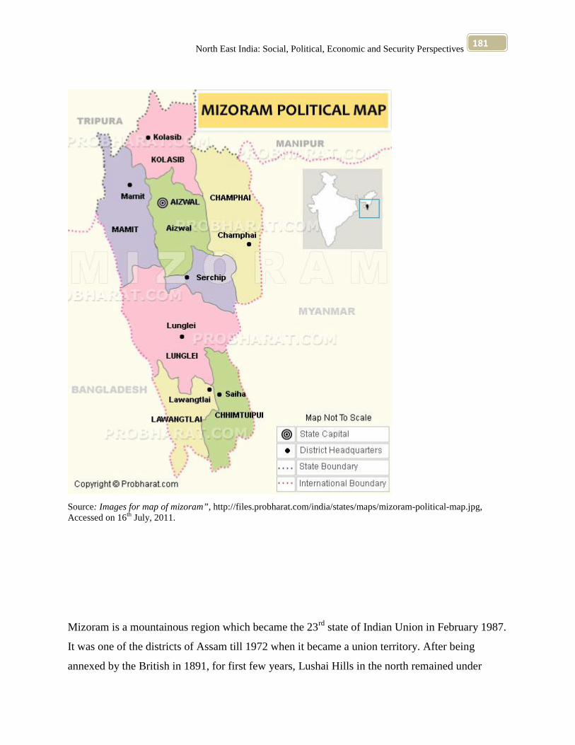
North East India: Social, Political, Economic and Security Perspectives181
Source: Images for map of mizoram”, http://files.probharat.com/india/states/maps/mizoram-political-map.jpg,Accessed on 16th July, 2011.
Mizoram is a mountainous region which became the 23rd state of Indian Union in February 1987.
It was one of the districts of Assam till 1972 when it became a union territory. After being
annexed by the British in 1891, for first few years, Lushai Hills in the north remained under
North East India: Social, Political, Economic and Security Perspectives182
Assam while the southern half remained under Bengal. Both these parts were amalgamated in
1898 into one district called Lushai Hill district under Chief Commissioner of Assam. With the
implementation of the North- Eastern Reorganisation Act in 1972, Mizoram became a union
territory and as a sequel to the signing of the historic memorandum of settlement between
Government of India and Mizo National Front in 1986, it was granted statehood on 20th
February, 1987. 60
Sandwitched between Myanmar (formerly Burma) in east and south and Bangladesh in west,
Mizoram occupies an area of great strategic importance in northern- eastern corner of India. Hills
in Mizoram run from north to south with a tendency to be higher in east to the territory and
tapering in north and south. Average height of hills is about 900 metre, the highest peak being
Blue Mountain (Phawngpui) rising to 2,210 metre. Mizoram has great natural beauty and an
endless variety of landscape and it is rich in fauna and flora. 61
Of the early history of Mizos, as of other hill tribes of India’s north- east, very little is known. An
interesting feature of the pre- British period Mizo hills, like that of Naga hills, was its pre- State
society. The Lushais, in spite of being surrounded by the powerful and organized states, were
completely unaware of any state form. 62
The Mizo Union also raised unarmed volunteer force for launching a movement for creation of a
separate Mizoram State, and when the Mizo Union announced its programme for non- violent
direct action, the danger of direct confrontation between the two parties became real. 63
In October 1965 a deputation of the Mizo Union called on the then Prime Minister Lal Bahadur
Shastri, in New Delhi to press the demand for early constitution of Mizoram State.64
60 “Mizoram” (1996) Encyclopaedia of India and Her States” Volume 9, ed. Verinder Grover and Ranjan Arora,Published by Deep and Deep Publications, F- 159, Rajouri Gander, New Delhi- 110027, p 397.61 Ibid, p 398.62 “Economic Development” (2001), Encyclopaedia of North –East India, Volume 5, ed. H.M. Bareh, MittalPublications, New Delhi- 110059 (India), p 174.63 Ibid. p 174.64 Ibid. p 174.

North East India: Social, Political, Economic and Security Perspectives183
In February, 1987 Mizoram was born as the State of Indian Union. It was one of the districts of
Assam till 1972, when it became a Union Territory. Surrounded by Myanmar (formerly Burma)
in the east and south and Bangladesh in the west, Mizoram occupies an area of great strategic
importance in the north- eastern corner of India with Aizawl as its capital. 65
The hills in Mizoram run from north to south with a tendency to be higher in the east and
tepering in the north and south. The State has the most variegated hilly terrain with its steep hills
being separated by rivers which create deep gorges between the hill ranges. 66
The word ‘Mizo’ is a generic term and used to mean hillmen or highlanders. They came under
the influence of the British Missionaries in the 19th century. Consequently, most of the Mizos
now profess Christianity. One of the gains of Missionary activities was the spread of education.67
The Mizos’ code of ethics or Dharma centred round Tlawngaihna, an untranslatable term
meaning that everyone should be hospitable, kind, unselfish and helpful to others. It is the core
of their philosophy of life. In war or peace, in dealing with individuals or in the midst of a crowd,
it was their spirit of Tlawngaihna which guided their thoughts and actions. 68
The most colourful and distinctive dance of the Mizos is called Cheraw. As long bamboo staves
are used for this dance, many people call it the bamboo dance. 69
The State of Mizoram having common borders with two foreign countries, viz., Myanmar and
Bangladesh, occupies an area of great strategic importance on the political map of India.70
65 “Mizoram- The Exotic Land of Highlanders” (2004) , Discovery of North- East India, Volume 8, ed. S.K. Sharmaand Usha Sharma, Mittal Publications, A- 110, Mohan Garden, New Delhi 110059 (India) p 221.66 Ibid. p 221.67 Ibid. p 221.68 Ibid. p 221.69 Ibid. p 22170 “Preface” (2004) , Discovery of North- East India, Volume 8, ed. S.K. Sharma and Usha Sharma, MittalPublications, A- 110, Mohan Garden, New Delhi 110059 (India) p xi.

North East India: Social, Political, Economic and Security Perspectives184
The total area of Mizoram is 21,081 sq km. 71
Nagaland
Map 4.7
71 Ibid, p 25.

North East India: Social, Political, Economic and Security Perspectives185
Source: “Nagaland Tourist Map,” http://mappery.com/maps/Nagaland-Tourist-Map.jpg, Accessed on 16th July,2011.
The Nagas too have their share of legends and folklore regarding their origin and evolution
through the ages. Nagas are basically tribal people and very tribe had its own effective system of
self- governance from time immemorial. In the 12th and 13th centuries, gradual contact with the
North East India: Social, Political, Economic and Security Perspectives186
Ahoms of present day Assam was established, but this did not have any significant impact on the
traditional Naga way of life. However, in the 19th century under British administration. After
Independence, this territory was made a centrally administered area in 1957, administered by the
Governor of Assam. It was known as the Naga Hills Tuensang Area. This however, failed to
quell popular aspirations and unrest began. Hence, in 1961, this was renamed as Nagaland and
after given the status of a state in the Indian Union was formally inaugurated in 1963. Situated in
the extreme north- east of the country, the state is bounded by Arunachal Pradesh in the north,
Assam in the west Manipur in the south and by Myanmar (formerly Burma) in the east.72
Nagaland is one of the smallest states of India (now Sikkim is the smallest). It was carved out in
the Indian map as sixteenth state of the Union on 1st December, 1963 and inaugurated by the then
President of India, Dr S. Radhakrishnan. The State of Nagaland has been formed with the
erstwhile Naga Hills Districts of Assam (established in 1881) and the Tuensang Division of
NEFA. 73
The administrative unit, previously known as Naga Hills and Tuensang Area (NHTA) came into
being on 1st December 1957, following the acceptance by the Government of India of a
resolution passed in the first Naga People’s Convention 1957. In another convention at
Mokokchung in October 1959 it was advised to rename the areas as ‘Nagaland.’ The
Government of India accepted the recommendation and renamed the area on 18th February 1961.
It was a mere preliminary step to the Constitution of Nagaland as a full-fledged State. On the
same day an Executive Council consisting of five members with a Chairman called the Chief
Executive Councillor and an interim body of 42 members were constituted. 74
Traffic and trade between village having been minimal as a result of the practice of head-
hunting, each village grew in isolation and the authority of the chief was unquestioned. The chief
72 “Nagaland” (1996) Encyclopaedia of India and Her States” Volume 9, ed. Verinder Grover and Ranjan Arora,Published by Deep and Deep Publications, F- 159, Rajouri Gander, New Delhi- 110027, pp 449-450.73 T.Raatan (2004) “Formation of State,” Encyclopaedia of North- East India, Volume 3, Kalpaz Publications,Delhi- 110052, p 78.74 Ibid. p 78.

North East India: Social, Political, Economic and Security Perspectives187
was a judge, administrator and commander rolled into one and indeed it was imperative that he
be a warrior- chief more than anything else. Families of various clans lived in a village and it
was the clans not the tribe which was the rallying point among the Nagas- Tribal solidarity came
late, much later, and even today advanced and supposedly progressive Naga tribes bicker over
my and your village. 75
The solidarity and the honour of the early Naga village was vested in the chief who dispensed
justice in conformity with recognized and accepted codes and customs. With the coming of the
British, the village chiefs, once supreme rulers suffered an erosion of their authority though the
British administration set about subtly in doing this. Being interested only in maintaining law
and order and preventing head-hunting the British left the village well alone to their chiefs and
interfered little or not at all in the day-to- day administration. So it is that the erstwhile village
administration still survives and the government administration. Gives way before the customs of
the tribes. 76
The traditional political system developed in the context of communities is families, extensions
of families (clans) and tribes. They belong to the same kinship group sharing a common culture,
common descent and a common territory. 77
Important functions of the council may be mentioned; the councilors decide disputes arising
between individuals and they dispense the law of inheritance, adoption, marriage, divorce, theft
and murder. Functions of the council included the maintenance of the village water supply and
foot- paths, construction of new paths, bridges across streams and rivers which are swollen
during the rainy season and are otherwise very difficult to cross. 78
It is an agrarian State and about 80 per cent of its population depends upon agriculture. Nagaland
is essential an agrarian state of the country. In some of the tribes of Nagas, working in jobs other
75 “Political Heritage” (2001), Encyclopaedia of North –East India, Volume 3, ed. H.M. Bareh, Mittal Publications,New Delhi- 110059 (India), p 115.76 Ibid, pp 115- 116.77 Ibid, p 116.78 Ibid, pp 119- 120.
North East India: Social, Political, Economic and Security Perspectives188
than farming, hunting, forestry and gathering is considered as a taboo. Although sedentary
agriculture is practiced but it is insignificant and confined to terraces around Kohima and in the
arrow river terraces alluvial fans. Shifting cultivation is the dominant agricultural system. 79
The total area of Nagaland is 16,579 sq km. 80
SikkimMap 4.8
79 T.Raatan (2004) “Agricultural and Industrial Development,” Encyclopaedia of North- East India, Volume 3,Kalpaz Publications, Delhi- 110052, p 80.80 Ibid, p 25.
North East India: Social, Political, Economic and Security Perspectives189
Source: “Images for map of Sikkim,” http://maps.newkerala.com/Sikkim-Travel-Map.jpg, Accessed on 16th July,2011.
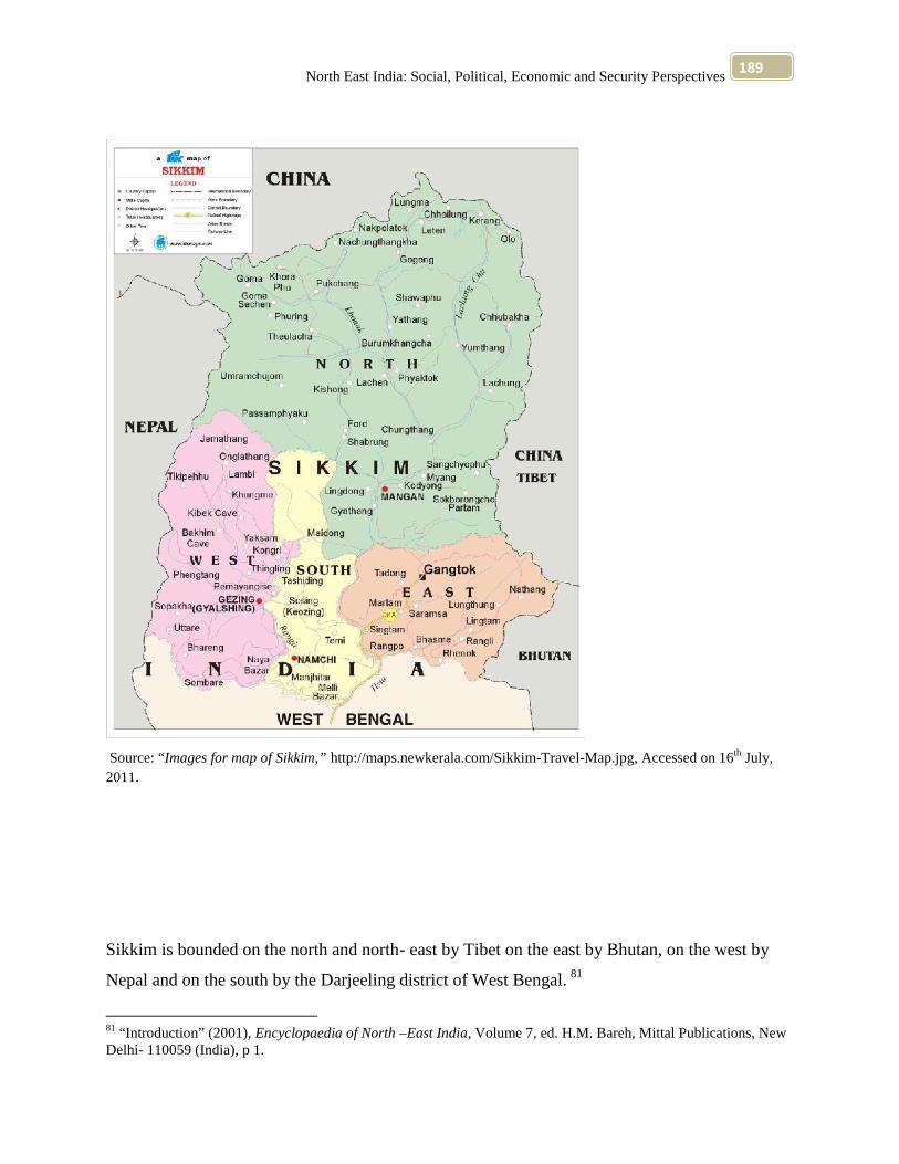
Sikkim is bounded on the north and north- east by Tibet on the east by Bhutan, on the west by
Nepal and on the south by the Darjeeling district of West Bengal. 81
81 “Introduction” (2001), Encyclopaedia of North –East India, Volume 7, ed. H.M. Bareh, Mittal Publications, NewDelhi- 110059 (India), p 1.

North East India: Social, Political, Economic and Security Perspectives190
Ethnicity affects the life of the individuals and groups in many ways. Indeed, ethnicity has
become a ‘resource’ affiliations to which ultimately involves the realization of ‘privileges’ for a
section of the society. Role played by the constitutional provisions strengthens the ethnic
identity. Ethnic groups have ever time become strong ‘interest’ group and ethnicity a ‘resource.’
This dimension has created conflict situations. 82
The Bhutia, Lepcha and the Limbus were automatically recognized as the Sikkimese by the
regulations. But, it was not easily attainable even for the earliest Nepalese settlers in general,
who were later recognized and granted Sikkimese status after initial resistance from a section of
(anti- Nepalese) ruling elites, though the plainsmen had always been excluded. 83
The Sikkim ruling Durbar had maintain a register of all such legal settlers who were the Sikkim
i.e. Sikkimese. 84
Very little is known about the early history of Sikkim. It is commonly believed that in the 17th
century Phuntsog Namgyal became the first leader of the Namgyal dynasty which ruled till
Sikkim joined Indian Union in 1975. A mountain state in the eastern Himalayas, Sikkim is bound
on west by Nepal, on north by Tibet, on east by Bhutan and on south by west Bengal. Sikkim is
strategically important for India as it lies astride the shortest route from India to Tibet. The state
is entirely mountainous covered with dense forests where sal, simal, bamboo and other trees
thrive, some finest forests lie in the northern most areas in Lachen and Lachung. Mountain rise to
7,000 m and above, Kanchenjunga being world’s third highest peak. Sikkim had several hundred
varieties of orchids and is frequently referred to as ‘botanist’s paradise.’ 85
82 “Ethnicity and Resource Management” (2001), Encyclopaedia of North –East India, Volume 7, ed. H.M. Bareh,Mittal Publications, New Delhi- 110059 (India), p 23.83 Ibid, p 33.84 Ibid. p 3385 “Sikkim” (1996) Encyclopaedia of India and Her States” Volume 9, ed. Verinder Grover and Ranjan Arora,Published by Deep and Deep Publications, F- 159, Rajouri Gander, New Delhi- 110027, p 533.
North East India: Social, Political, Economic and Security Perspectives191
Integration with the Indian Union has been unique mainly because Sikkim had for long earlier
remained a protectorate. The experience has shown no trace of socio- cultural alienation,
political resistance and concomitant problems of adaptability and assimilation, despite the fact
that Sikkim had its own socio- cultural and political- economic systems a traditional paradigm of
development and powerful neighbour in China which is yet to recognize it as part of India.
Historically, also it represented a very different political culture from the mainstream India’s. 86
The present population of the State is primarily composed of Lepchas, Bhutias, Nepalese and the
plains people who represent different ethnic groups settled in the State at different times. The
plains people are largely the business communities (Marwaris of Rajasthan and Baniyas of Bihar
and Uttar Pradesh), Brahmins, Kshatriyas and others who come from the Indo- Gangetic plains
that cover Bihar, Uttar Pradesh, Haryana, Punjab, Kerala, West Bengal, Tamil Nadu and Andhra
Pradesh.87
The people of Sikkim mostly live in small houses in village. The houses by and large are similar
to primitive dwellings. However, the Bhutia and Lepcha houses are different than the Nepalese
houses. The Lepcha and Bhutia dwellings are constructed on taller stone foundations and they
are often supported by poles made up of tree- trunks. 88
Before its incorporation into India, Sikkim had remained, administratively, for many years, in
relative isolation. The socio- political structure centred on a hierarchy of lamas and monasteries
and the temporal ruler called Chogyal. The kingdom with its system of feudal, autocratic
bureaucracy was formed by the immigrant Bhutias in cooperation with the local Lepcha chiefs.
Prior to the Bhutia immigration there was no central political power in Sikkim but only local
86 Mahendra P. Lama (1996) “Sikkim: 20 Years after Merger” Encyclopaedia of India and Her States” Volume 9,ed. Verinder Grover and Ranjan Arora, Published by Deep and Deep Publications, F- 159, Rajouri Gander, NewDelhi- 110027, p 605.87 T.Raatan (2004) “Various Ethnic Groups,” Encyclopaedia of North- East India, Volume 3, Kalpaz Publications,Delhi- 110052, p 17.88 T.Raatan (2004) “Way of Living,” Encyclopaedia of North- East India, Volume 3, Kalpaz Publications, Delhi-110052, p 29.
North East India: Social, Political, Economic and Security Perspectives192
Lepcha Chiefs were there in order to administer their respective villages. The installation of first
King Phuntso Nangyal in 1642 was recognized by the Dalai Lama in Tibet. 89
The total area of Sikkim is 7,096 sq km. 90
TripuraMap 4.9
89 T.Raatan (2004) “Political and Administrative Developments,” Encyclopaedia of North- East India, Volume 3,Kalpaz Publications, Delhi- 110052, p 35.90 Ibid, p 25.

North East India: Social, Political, Economic and Security Perspectives193
Source: “Images for map of tripura,” http://tripura.nic.in/Trjpg.jpg, Accessed on 16th July, 2011.
History of Tripura dates back to the Mahabharata, the Puranas and pillar inscriptions of emperor
Ashoka. There are no historical records available of Tripura except Rajmala which is the

North East India: Social, Political, Economic and Security Perspectives194
chronicle of the kings of the ruling family of Tripura. According to it, rulers were known by the
surname ‘Fa’ meaning ‘father.’ There is a reference of rulers of Bengal helping Tripura Kings in
the 14th century. Kings of Tripura had to face frequent Mughal invasions with varying successes.
They defeated Mohammedan sultans of Bengal in several battles. Nineteenth century marked the
beginning of the modern era in Tripura when king Maharaja Birchandra Manikya Bahadur
modelled his administrative set- up on the British India pattern and brought in various reforms
his successors ruled over Tripura till 1947 when it was annexed to Indian Union. In 1972, this
territory attained the status of a full-fledged state along with Manipur and Meghalaya. Tripura is
strategically situated between the rivers valleys of Burma and Bangladesh. Encircled almost on
three sides by Bangladesh, it is linked with Assam only in the north- east.91
In ancient period, prior to the establishment of the Muslim rule in Bengal, Tripura had no distinct
political status. It had virtually no significance at the time. The archaeological evidences found in
the region prove the fact that a huge portion of this region, particularly south- western part of the
present state of Tripura, was political attached to the Kingdoms of Eastern Bengal known as
Samatata Vanga and Harikela. 92
Since its incorporation into the periphery of the British Indian empire in the late eighteenth
century, the tribal princely Tripura was subject to a series of major social changes- demographic
and socio- economic- which laid the critical basis of the rise of the political movements and
parties in the state in the twentieth century, and remain the roots of much of the later- day
tensions in Tripura’s state politics. Those changes form an indispensable part of the modern
social history of Tripura’s communism is unintelligible without them. 93
Among its people the overwhelming majority were the tribals, the rest being immigrants both
tribals and non- tribals. The tribals and immigrants confronted each other, thereby creating a
91 “Tripura” (1996) Encyclopaedia of India and Her States” Volume 9, ed. Verinder Grover and Ranjan Arora,Published by Deep and Deep Publications, F- 159, Rajouri Gander, New Delhi- 110027, p 623.92 T.Raatan (2004) “Land and the People,” Encyclopaedia of North- East India, Volume 3, Kalpaz Publications,Delhi- 110052, p 141.93 Harihar Bhattacharyya (1996) “The State and Social Changes in Colonial Tripura” Encyclopaedia of India andHer States” Volume 9, ed. Verinder Grover and Ranjan Arora, Published by Deep and Deep Publications, F- 159,Rajouri Gander, New Delhi- 110027, p 639.

North East India: Social, Political, Economic and Security Perspectives195
demographic imbalance in the society. The tribals, divided amongst themselves into a number of
separate communities, each carrying its banner of separate socio- cultural heritage, naturally
nurtured the spirit of developing themselves as distinct ethnic groups. The dormant sub-
nationalist sentiment had to confront the uneven competition with one of the most advanced and
prosperous ethnic group the Bengalee. The Maharajas of Tripura, despite being tribals, saw in
the growing Bengali art and culture a safe saddle for power, even if it had rung the death- knell
for the tribals’ aspiration for developing their latent ethnic consciousness. In the wave of
Hinduization patronised by the rulers, the tribals were own indigenous socio- cultural pursuits.
Their language ‘Kok Borak’ which had the necessary qualities to be fully developed in the years
to come was compelled to be humiliated before the rich Bengali language. 94
For an understanding of the rise of political consciousness among the tribals of Tripura, to go
into the history of the state formation process in Tripura since the early part of the 15th century.
At that time the main tribes living in Tripura were the Tripura, Kuki, Riang and Jamatiya who
belonged to the Indo- Mongoloid stock. They migrated to Tripura through Assam, Sylhet and
Cachar in successive waves. 95
The disturbance of the demographic equilibrium caused by the large- scale inflow of Bengali-
speaking immigrants from East Pakistan, now Bangladesh, the growing pressure on land, acute
food shortage, the lengthening shadow of unemployment, and the backwardness of the hill areas
of the State have generated serious socio- economic tensions and ethnic conflict in this north-
eastern State. The tribal aborigins have been swamped by the Bengali migrants who have taken
over increasing charge of the administration, State’s trade and commerce and its cultural life. 96
94 Pradip Kumar Basu (1996) “The Communist Movement in Tripura: Its Evolution (1935- 75)” Encyclopaedia ofIndia and Her States” Volume 9, ed. Verinder Grover and Ranjan Arora, Published by Deep and Deep Publications,F- 159, Rajouri Gander, New Delhi- 110027, pp 651- 652.95 J.B. Ganguly (1996) “Tripura Tribals and Mainstream: Tripura Politics” Encyclopaedia of India and Her States”Volume 9, ed. Verinder Grover and Ranjan Arora, Published by Deep and Deep Publications, F- 159, RajouriGander, New Delhi- 110027, pp 663.96 “The Gathering Storm in Tripura” (2001), Encyclopaedia of North –East India, Volume 8, ed. H.M. Bareh, MittalPublications, New Delhi- 110059 (India), p 148.
North East India: Social, Political, Economic and Security Perspectives196
The native Tripura tribals with their primitive economy and archaic ways of eking out a
livelihood have a had subordinate place throughout. But, the visible signs of relative prosperity
of the non- tribals in the very area where they have been living in abject penury all these years
resulted in serious heart burn, bitterness, jealousies, prejudice and conflict. Tripura is situated on
the north- east corner of India. 97
In addition, the submersion of the tribal people in the growing mass of non- tribals has led to
acculturation in a manner and on a scale which has but few parallels in the country. 98
The process of acculturation continues to cut deeper into the social matrix as points of contact
between the tribals and non- tribal section of the population keep on enlarging. However, one
may subjectively react to its results, one thing is certain, namely, that the equilibrating
mechanism within the structure of tribal societies in Tripura is now largely non- operative and it
does not have much chance to redeem itself. The cauldron of tribal unrest in Tripura has begun to
simmer. If timely measures are not taken to make amends, it will not be long before it starts
boiling.99
The total area of Tripura is 10,491 sq km. 100
Relevance of North East for India’s Security
Northeast India has been witnessing two distinctive discourses: reiterative and declarative. The
two seem to be characteristic of not only the Indian state and its machineries, but also its
counterparts: the protesting voices in the region. 101
97 Ibid. pp 148, 16798 Ibid, p 167.99 Ibid. pp 148, 167100 Ibid, p 25.101 Bhagat Oinam (2009) “Preparing for a Cohesive Northeast Problems of Discourse,” Beyond Counter-insurgencyBreaking the Impasse in Northeast India, ed. Sanjib Baruah, Oxford University Press, YMCA Library Building, JaiSingh Road, New Delhi 110001, p 172.

North East India: Social, Political, Economic and Security Perspectives197
The influence and the endurance of insurgency in the Northeast are due to the fact that armed
groups are embedded in the workings of northeastern civilian politics. Acting like the
combination of a racketeer and a policy lobby, an insurgent group can cut political deals and
influence elections, and become enmeshed in a network of extortion and corruption that makes it
difficult for politicians to bureaucrats to act independently of the rebels. 102
Delhi’s response to the uprisings in the Northeast has been a two-pronged strategy of tough
counter-insurgency combined with development aid aimed at ending popular grievance. The
argument over which of these two strategies is more important is misguided. Neither confronts
the local political role of violence in the Northeast: both security and development programmes
are inefficacious in the face of a system of violent politics, corruption, and immunity for the
powerful. When outside security forces stay in the region for too long they create resentment
among civilians, but violence breaks out when the local security forces are in control because
they do not have the ability and/ or incentives to resist the ties between insurgents and politics.
Underdevelopment persists because aid ends up being used for private gain, and lawlessness
destroys the investment climate and limits entrepreneurialism. 103
Civilians in the Northeast, as well as insurgents and local politicians, have little faith that the
formal political process can be purged of violence. The means to do so are reform of and support
for local police and judicial institutions. Violence, electoral manipulation, corruption, black
market transactions, extortion, and inter-communal violence are only rarely effectively
prosecuted in the Northeast. Illegal acts by security forces and agents of the centre are not always
dealt with quickly and decisively. Only in an environment where civilians feel safe and would-be
rebels or collaborators are deterred by a belief that there may be real penalties for their actions,
does the equilibrium described above dissolve.104
102 Bethany Lacina (2009) “Rethinking Delhi’s Northeast India Policy Why neither Counter-insurgency nor WinningHearts and Minds is the Way Forward,” Beyond Counter-insurgency Breaking the Impasse in Northeast India, ed.Sanjib Baruah, Oxford University Press, YMCA Library Building, Jai Singh Road, New Delhi 110001, p 333.103 Ibid, pp 338- 339.104 Ibid, p 340.

North East India: Social, Political, Economic and Security Perspectives198
The political uncertainty in Northeast India has been a major factor in shaping India’s Myanmar
policy is quite apparent. Indeed, arguably it is India’s security anxieties, getting Myanmar to act
against Northeast Indian insurgent groups that takes shelter in Myanmar, rather than a desire to
give the Look East policy a continental orientation that explains Indian policy towards Myanmar,
especially the U-turn in its attitude toward the military regime. Security expert Bibhu Prasad
Routray wrote an article looking at the potential effects of the road- building project between
Northeast India and Thailand through Myanmar on northeastern insurgencies. 105
Geography has also affected the pattern of development in the North East and the Partition
caused havoc both in the geography and the economy of the North East. To begin with, the entire
land mass of the North East is now connected to the rest of India by a tenuous 22 kilometre link
along the Siliguri Corridor; more than 99 per cent of the borders of the North East abut other
countries: China, Bhutan, Myanmar and Bangladesh. Some of these countries have not been too
friendly and, across a porous international border, have been only too willing to assist militant
activity in India. Others, while not anti-India in their approach, have not been in a position to
prevent anti-Indian activity from their soil. 106
Insurgency flourishes when the people have a feeling of separate identity on the basis of
ethnicity, culture or history. This is compounded by a sense of neglect, exploitation and
discrimination, and immensely aggravated by bad governance, corruption and economic
backwardness. All these factors exist in the North East. The key to the situation, clearly, is to
provide good, corruption-free governance, and economic development. 107
It is rightly said that when people in Delhi think of the Northeast, they think of the distance, and
that translates itself into a mental gap. When the people of the Northeast think of Delhi, they
105 Sanjib Baruah (2005) “Beyond Durable Disorder Northeast India and the Look East Policy,” Durable DisorderUnderstanding the Politics of Northeast India, Oxford University Press, YMCA Library Building, Jai Singh Road,New Delhi 110001, p 228.106 S.K. Sinha (2002) “Violence & Hope In India’s Northeast,” Faultlines Writing on conflict and resolution,Volume 10, ed. K.PS. Gill & Ajai Sahni, The Institute for Conflict Management, New Delhi, p 6.107 Ibid, p 21.

North East India: Social, Political, Economic and Security Perspectives199
think in terms of different levels of development, and this translates into an emotional gap. Hope
that these gaps can be bridged, and that, with changes in attitudes, the Northeast will take the
high road to peace and prosperity. 108
Autonomy and ethnicity have diverse faces and masks. A paradigm shift in perception and
policy-making occurs when they are viewed as part of the problem and not the solution.
Autonomy as practiced by us is accommodative but it is firmly controlled by the Centre and the
States, politically and bureaucratically. Autonomy to an ethnic group on the Indian side cannot
afford to ignore the condition of the same ethnic group across the border. One has to necessarily
strive towards achieving a far greater inter-government coordination. 109
The psychological integration of the NE with the rest of the county is of critical importance. One
also has to upgrade the policy and institutional structures to render effective such integration. 110
A critical futuristic threat perception vis-à-vis India’s North Eastern region has long preoccupied
many analysts and the Indian security establishment. The projected exercise would involve
Pakistan launching an attack on Jammu and Kashmir. At the other end, China would engage
Indian military in the latter’s Northeast with movement from Tibet, through Bhutan and via
Alipurduar in the Jalpaiguri district and consequently cut-off what is referred to as the eastern
chicken’s neck or the Shiliguri corridor. An Indian strategists’ nightmare come true. 111
The crucial Chinese objectives would be to capture a large amount of territory in northern
Sikkim to secure a strategic hold. In tactical terms, this would translate into denying a launching
pad to the Indian forces for an assault on Tibet. The other element of this thrust, it is projected,
108 Ibid. pp 6, 21109 Sushil K. Pillai (2002) “Three Matryoshkas Ethnicity, Autonomy and Governance,” Faultlines Writing onconflict and resolution, Volume 10, ed. K.PS. Gill & Ajai Sahni, The Institute for Conflict Management, New Delhi,p 35.110 Ibid. p 35111 Pinaki Bhattacharya (2002) “The Shiliguri Corridor Question Mark on Security,” Faultlines Writing on conflictand resolution, Volume 10, ed. K.PS. Gill & Ajai Sahni, The Institute for Conflict Management, New Delhi, p 107.

North East India: Social, Political, Economic and Security Perspectives200
would be centred on capturing areas in Bhutan, the ones traditionally claimed by the Chinese,
thus posing a direct threat to the Shiliguri Corridor, a key item on the agenda. 112
The Shiliguri Corridor is an area of 12,203 square kilometers connecting mainland India with the
outlying border States of the Northeast. As geographical configuration puts the North Eastern
States of the country (India) at a disadvantage for a lack of strategic depth, considered necessary
to provide a buffer, the tenuous lines of communication (that run through this corridor) connect
mainland India to the Northeast. The corridor’s dimension extends lengthwise approximately 200
kms with a width varying between 20 and 60 kilometres. 113
No coherent and effective policies can be drawn up for the restoration of an abiding peace in, and
for the enduring development of, the States of India’s Northeast unless they factor in these
various unorthodox elements of the political, administrative and socio-economic conditions
prevailing in this region. An obvious corollary is that the models and patterns of development
that have been applied, or that have succeeded in, other parts of the country, cannot mechanically
be extended to this region.114
The prospects for peace in India’s Northeast remain mixed. 115
Growing and increasing indiscriminate external support to all terrorist groupings, irrespective of
ideology or objective, particularly by Pakistan’s ISI, and the gradual cementing of linkages
between terrorist groups across international borders create further barriers to peace. The
problem is aggravated by the act that most such terrorist groupings operate out of safe havens in
112 Ibid, p 108.113 Ibid. pp 107-108114 Ajai Sahni & J. George (2000) “Security & Development in India’s Northeast: An Alternative Perspective,”Faultlines Writing on conflict and resolution, Volume 4, ed. K.PS. Gill & Ajai Sahni, The Institute for ConflictManagement, New Delhi, p 66.115 Ajai Sahni (2002) “Survey of Conflicts & Resolution in India’s Northeast,” Faultlines Writing on conflict andresolution, Volume 12, ed. K.PS. Gill & Ajai Sahni, The Institute for Conflict Management, New Delhi, p 109.

North East India: Social, Political, Economic and Security Perspectives201
neighbouring countries such as Bangladesh, Bhutan and Myanmar, and the weak regimes in
these countries find it impossible to check such activities on their soil. 116
116 Ibid, p 110- 111.
Top Related