


Languages
Pages
Legal


Central Park Avenue BRT Study Parking Utilization Survey
Westchester County, New York
June 30, 2008
Prepared for: Westchester County DOT
Prepared by:
STV Incorporated

Central Park Avenue BRT Assessment Study Westchester County DOT
____________________________________________________________________________________________
STV Incorporated 1 June 30, 2008
Study Purpose As part of the Central Park Avenue BRT Assessment Study, bus preferential treatments such as
exclusive bus lanes and bus queue jump lanes are being proposed within the available
shoulder/parking lane along Central Park Avenue. A preliminary parking study of Central Park
Avenue was performed by Westchester County DOT (WCDOT), which identified the parking
regulations along the corridor. Given that specific recommendations for locating bus lanes and
queue jump lanes have been identified, it was important to determine the level of parking utilization
at the sites where parking would be eliminated. This technical memorandum outlines the
methodology used to perform a detailed parking utilization study of the potentially affected areas
and its findings. The parking utilization study summarizes how many vehicles currently occupy on-
street parking spaces that could be removed by the BRT project.
Parking Data Collection Methodology STV collected and summarized the existing parking regulations and available on-street capacity
along those sections of the Central Park Avenue corridor that could potentially be affected by
BRT roadway preferential treatments such as bus lanes or queue jump lanes. Those locations
examined included:
1. Martine Avenue (north curb) from South Broadway to Court Street 2. Central Park Avenue from Hartsdale Avenue to Lawton Avenue (north and southbound roadways)
3. Central Park Avenue from Sadore Lane to Clifton Road (north and southbound roadways)
4. Central Park Avenue from Cowles Avenue to Clark Street (southbound roadway only) 5. Central Park Avenue from Sanford Street to McLean Avenue (southbound roadway only)
STV recorded parking occupancy information for each of the roadway segment identified above
for the weekday and weekend time periods of 8-10 AM, 11 AM-1 PM, 2-4 PM, and 5-7 PM.
Prior to performing the parking utilization surveys, STV and Westchester County DOT agreed
that these four, two-hour analysis periods should be examined as they would provide a
representative sample of parking activity data for a typical day. The parking surveys were
performed for two weekdays (April 2nd and 3
rd), one Saturday (April 12
th), and one Sunday
(April 13th) in 2008.
The data collection effort included recording one complete set of parking utilization information
for each study segment during each study period and day. STV field staff recorded the last three
digits of each vehicle parked on each block face within the parking analysis segments to record
the parking space occupancy and to estimate the length of time that such vehicles remain parked.
Parking durations were then estimated based on the number of consecutive two-hour analysis
intervals that a specific license plate number was observed parked within a given block face.
Appendix A includes the summarized parking data for each analysis day by study block face and
time of day.

Central Park Avenue BRT Assessment Study Westchester County DOT
____________________________________________________________________________________________
STV Incorporated 2 June 30, 2008
Parking Data Findings The curbside locations along Central Park Avenue that could potentially be used by a bus lane or
a bus queue jump lane have been divided into specific segments for the parking study. The study
locations were divided such that the parking operations (e.g., metered or unlimited parking)
within each segment are fairly similar and only one roadway bus preferential treatment (i.e., bus
lane or queue jump lane) is being proposed per section. Following are the parking utilization
survey findings for each study location.
Martine Avenue from South Broadway to Court Street
The Central Park Avenue BRT Assessment Study proposes to eliminate some or all of the
parking along the north curb of Martine Avenue between South Broadway and Mamaroneck
Avenue to provide either a bus lane or a queue jump lane approaching Mamaroneck Avenue (see
Figure 1). This segment of Martine Avenue abuts the White Plains City Center to the north, a
residential/retail tower that provides access to a multi-level public parking garage from Martine
Avenue.
A total of 14 metered parking spaces currently exist along Martine Avenue between South
Broadway and Mamaroneck Avenue. Generally, at least 70% (ten parking spaces) of these
parking spaces are occupied during the 11 AM to 1 PM midday and 2-4 PM and 5-7 PM
afternoon shopping periods on both weekdays and weekends (see Table 1). Posted regulations
limit parking durations to two or three hours on all days except Sunday1 and the parking
observation data confirms that most vehicles park for a short duration (i.e., three hours or less)
along this segment (see Figure 2).
The City of White Plains is currently removing the commercial vehicle loading zone along the
north curb of Martine Avenue between Mamaroneck Avenue and Court Street in order to
dedicate the entire block as a bus lane/stop.
1 Parking regulations are two-hour metered parking from 9 AM to 6 PM and three-hour metered parking from 6 to 9
PM, except Sunday.

Central Park Avenue BRT Assessment Study Westchester County DOT
____________________________________________________________________________________________
STV Incorporated 3 June 30, 2008
Figure 1: Martine Avenue east of Mamaroneck Avenue
Martin
e Ave
Mamaronec
k Ave
City
Center
Proposed
bus lane
Table 1: Parking Utilization
North Curb of Martine Avenue between South Broadway and Mamaroneck Avenue
Weekday 14 7 50% 11 79% 11 79% 10 71%
Saturday 14 10 71% 12 86% 10 71% 14 100%
Sunday 14 10 71% 11 79% 12 86% 11 79%
Percent
Occupied 5-7 PM
Percent
Occupied
Percent
Occupied
11 AM -
1 PM
Percent
Occupied 2-4 PM
Time
Period
Total # of
Spaces8-10 AM

Central Park Avenue BRT Assessment Study Westchester County DOT
____________________________________________________________________________________________
STV Incorporated 4 June 30, 2008
Figure 2: Parking Duration for
North Curb of Martine Avenue between South Broadway and Mamaroneck Avenue
0%
20%
40%
60%
80%
100%
0 - 3 3 - 6 6 - 9 9 - 12
Parking Duration (hours)
Percentage of Vehiclees
Weekday
Saturday
Sunday
Hartsdale Avenue
The BRT study proposes to relocate the north and southbound Central Park Avenue bus stops
from the south side of Hartsdale Avenue to the north side. In addition to the bus stop relocations,
bus queue jump lanes are proposed for both Central Park Avenue approaches to minimize the
traffic delays that buses currently experience (see Figure 3).
Figure 3: Central Park Avenue at Hartsdale Avenue
Central Ave
Hartsdale Ave
Proposed
southbound
BRT Station /
queue jump
Proposed
northbound
BRT Station
A total of five metered parking spaces would be removed by the proposed relocation of the
southbound Central Park Avenue bus stop to the curb north of Hartsdale Avenue. On weekdays,
typically only one vehicle is parked within these five metered spaces and generally three to five

Central Park Avenue BRT Assessment Study Westchester County DOT
____________________________________________________________________________________________
STV Incorporated 5 June 30, 2008
vehicles park in these spaces during the peak periods on weekends (see Table 2). The parking
regulation adjacent to the southbound roadway is two-hour metered parking from 8 AM to 8 PM
weekdays; consequently, there is a higher parking occupancy on weekends. Most of the vehicles
park for a short duration and are generally customers of the adjacent Duane Reade Pharmacy.
This pharmacy provides off-street parking in the rear of the building; however, it appears that
several customers opt to park on-street for convenience.
Table 2: Parking Utilization for Central Park Avenue north of Hartsdale Avenue
Northbound 28 8 29% 13 46% 15 54% 10 36%
Southbound 5 0 0% 1 20% 1 20% 1 20%
Northbound 28 10 36% 14 50% 13 46% 22 79%
Southbound 5 2 40% 3 60% 4 80% 5 100%
Northbound 28 21 75% 25 89% 23 82% 19 68%
Southbound 5 1 20% 5 100% 3 60% 2 40%
Weekday
Saturday
Sunday
Percent
Occupied 5-7 PM
Percent
Occupied
Time
Period
Total # of
Spaces8-10 AM
Percent
Occupied
11 AM -
1 PM
Percent
Occupied 2-4 PM
Roadway
Direction
Approximately seven of the 28 metered parking spaces along northbound Central Park Avenue
north of Hartsdale Avenue would be removed with the proposed bus stop relocation. Of these 28
metered spaces, up to 15 are occupied during the peak weekday period (2-4 PM) and up to 25 are
occupied during the peak weekend peak period (Sunday between 11 AM and 1 PM). The
parking regulation along northbound Central Park Avenue is two-hour metered parking from 8
AM to 8 PM except Sunday; consequently, the highest parking utilization was observed on
Sunday. Similar to the on-street parking along the southbound roadway, parking durations along
the northbound roadway are generally less than three hours (see Figure 4). Also, on- and off-
street parking is provided behind the stores on the northeast and southeast corners of the
intersection within a reasonable walking distance of Central Park Avenue and Hartsdale Avenue.
Central Park Avenue BRT Assessment Study Westchester County DOT
____________________________________________________________________________________________
STV Incorporated 6 June 30, 2008
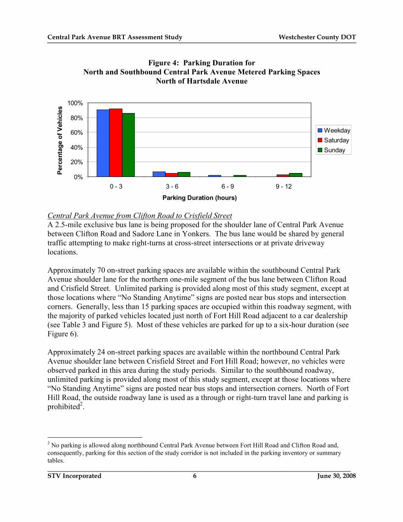
Figure 4: Parking Duration for
North and Southbound Central Park Avenue Metered Parking Spaces
North of Hartsdale Avenue
0%
20%
40%
60%
80%
100%
0 - 3 3 - 6 6 - 9 9 - 12
Parking Duration (hours)
Percentage of Vehicles
Weekday
Saturday
Sunday
Central Park Avenue from Clifton Road to Crisfield Street
A 2.5-mile exclusive bus lane is being proposed for the shoulder lane of Central Park Avenue
between Clifton Road and Sadore Lane in Yonkers. The bus lane would be shared by general
traffic attempting to make right-turns at cross-street intersections or at private driveway
locations.
Approximately 70 on-street parking spaces are available within the southbound Central Park
Avenue shoulder lane for the northern one-mile segment of the bus lane between Clifton Road
and Crisfield Street. Unlimited parking is provided along most of this study segment, except at
those locations where “No Standing Anytime” signs are posted near bus stops and intersection
corners. Generally, less than 15 parking spaces are occupied within this roadway segment, with
the majority of parked vehicles located just north of Fort Hill Road adjacent to a car dealership
(see Table 3 and Figure 5). Most of these vehicles are parked for up to a six-hour duration (see
Figure 6).
Approximately 24 on-street parking spaces are available within the northbound Central Park
Avenue shoulder lane between Crisfield Street and Fort Hill Road; however, no vehicles were
observed parked in this area during the study periods. Similar to the southbound roadway,
unlimited parking is provided along most of this study segment, except at those locations where
“No Standing Anytime” signs are posted near bus stops and intersection corners. North of Fort
Hill Road, the outside roadway lane is used as a through or right-turn travel lane and parking is
prohibited2.
2 No parking is allowed along northbound Central Park Avenue between Fort Hill Road and Clifton Road and,
consequently, parking for this section of the study corridor is not included in the parking inventory or summary
tables.

Central Park Avenue BRT Assessment Study Westchester County DOT
____________________________________________________________________________________________
STV Incorporated 7 June 30, 2008
Table 3: Parking Utilization for Central Park Avenue
between Crisfield Street and Clifton Road
Time
Period
Roadway
Direction
Total # of
Spaces8-10 AM
Percent
Occupied
11 AM -
1 PM
Percent
Occupied 2-4 PM
Percent
Occupied 5-7 PM
Percent
Occupied
Northbound 24 0 0% 0 0% 0 0% 0 0%
Southbound 70 4 6% 6 9% 10 14% 8 11%
Northbound 24 0 0% 0 0% 0 0% 0 0%
Southbound 70 5 7% 9 13% 12 17% 15 21%
Northbound 24 0 0% 0 0% 0 0% 0 0%
Southbound 70 1 1% 3 4% 10 14% 11 16%
Weekday
Saturday
Sunday
Figure 5: Southbound Central Park Avenue On-Street Parking north of Fort Hill Road
Central Ave
Location of most
on-street parking
activity

Central Park Avenue BRT Assessment Study Westchester County DOT
____________________________________________________________________________________________
STV Incorporated 8 June 30, 2008
Figure 6: Parking Duration for Central Park Avenue
between Crisfield Street and Clifton Road
0%
20%
40%
60%
80%
100%
0 - 3 3 - 6 6 - 9 9 - 12
Parking Duration (hours)
Percentage of Vehicles
Weekday
Saturday
Sunday
Central Park Avenue from Crisfield Street to Sadore Lane
Approximately 134 on-street parking spaces are available within the southbound Central Park
Avenue shoulder lane for the southern 1.5-mile segment of the bus lane between Crisfield Street
and Sadore Lane. Unlimited parking is provided along most of this study segment, except at
those locations where “No Standing Anytime” signs are posted near bus stops and intersection
corners.
Up to 90 vehicles were observed parked along southbound Central Park Avenue within this
roadway segment, with the peak parking occupancy occurring during the weekday midday 11
AM to 1 PM period (see Table 4). A large cluster of on-street parking was observed along
southbound Central Park Avenue, north of Melrose Avenue (see Figure 7). Given that off-street
parking is available within the adjacent retail properties/car dealership and that the parking
duration for nearly 50% of the vehicles is over six hours (see Figure 8), it is assumed that most of
the vehicles are employees parking on-street so as to preserve off-street parking for customers.

Central Park Avenue BRT Assessment Study Westchester County DOT
____________________________________________________________________________________________
STV Incorporated 9 June 30, 2008
Table 4: Parking Utilization for Central Park Avenue
between Sadore Lane and Crisfield Street
Time
Period
Roadway
Direction
Total # of
Spaces8-10 AM
Percent
Occupied
11 AM -
1 PM
Percent
Occupied 2-4 PM
Percent
Occupied 5-7 PM
Percent
Occupied
Northbound 123 38 31% 77 63% 72 59% 60 49%
Southbound 134 77 57% 90 67% 86 64% 62 46%
Northbound 123 54 44% 72 59% 73 59% 71 58%
Southbound 134 77 57% 86 64% 83 62% 66 49%
Northbound 123 36 29% 39 32% 47 38% 41 33%
Southbound 134 27 20% 43 32% 49 37% 33 25%
Sunday
Weekday
Saturday
Figure 7: Southbound Central Park Avenue On-Street Parking north of Melrose Avenue
Central Ave
Melrose Ave
Cluster of southbound
on-street parking
activity
Figure 8: Parking Duration for Southbound Central Park Avenue
between Sadore Lane and Crisfield Street
0%
20%
40%
60%
80%
100%
0 - 3 3 - 6 6 - 9 9 - 12
Parking Duration (hours)
Percentage of Vehicles
Weekday
Saturday
Sunday

Central Park Avenue BRT Assessment Study Westchester County DOT
____________________________________________________________________________________________
STV Incorporated 10 June 30, 2008
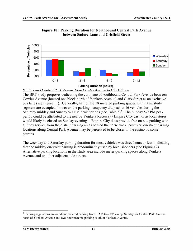
Approximately 123 on-street parking spaces are available within the northbound Central Park
Avenue shoulder lane for the southern 1.5-mile segment of the bus lane between Crisfield Street
and Sadore Lane3. Up to 77 vehicles were observed parked along northbound Central Park
Avenue within this roadway segment, with the peak parking occupancy occurring during the
weekday midday 11 AM to 1 PM period, the same peak period as the southbound roadway. A
large cluster of on-street parking was observed along northbound Central Park Avenue, north of
Sadore Lane, near a pair of strip mall buildings with a limited number of off-street parking
spaces (see Figure 9). The parking duration for most vehicles on northbound Central Park
Avenue through this segment is three hours or less, indicative of short-term customer parking
(see Figure 10).
Figure 9: Northbound Central Park Avenue On-Street Parking north of Sadore Lane
Plymouth Ave
Central Ave
Sadore Ln
Cluster of northbound
on-street parking
activity
3 This parking space total does not include the 0.4-mile northbound Central Park Avenue service road segment
between Verona Avenue and Roxbury Drive as the bus lane would operate within the service road and not remove
curbside parking.
Central Park Avenue BRT Assessment Study Westchester County DOT
____________________________________________________________________________________________
STV Incorporated 11 June 30, 2008
Figure 10: Parking Duration for Northbound Central Park Avenue
between Sadore Lane and Crisfield Street
0%
20%
40%
60%
80%
100%
0 - 3 3 - 6 6 - 9 9 - 12
Parking Duration (hours)
Percentage of Vehicles
Weekday
Saturday
Sunday
Southbound Central Park Avenue from Cowles Avenue to Clark Street
The BRT study proposes dedicating the curb lane of southbound Central Park Avenue between
Cowles Avenue (located one block north of Yonkers Avenue) and Clark Street as an exclusive
bus lane (see Figure 11). Generally, half of the 18 metered parking spaces within this study
segment are occupied; however, the parking occupancy did peak at 16 vehicles during the
Saturday midday and Sunday 5-7 PM peak periods (see Table 5)4. The Sunday 5-7 PM peak
period could be attributed to the nearby Yonkers Raceway / Empire City casino, as local stores
would likely be closed on Sunday evenings. Empire City does provide free on-site parking with
a jitney service from the distant parking areas behind the horse track; however, on-street parking
locations along Central Park Avenue may be perceived to be closer to the casino by some
patrons.
The weekday and Saturday parking duration for most vehicles was three hours or less, indicating
that the midday on-street parking is predominantly used by local shoppers (see Figure 12).
Alternative parking locations in the study area include meter-parking spaces along Yonkers
Avenue and on other adjacent side streets.
4 Parking regulations are one-hour metered parking from 9 AM to 6 PM except Sunday for Central Park Avenue
north of Yonkers Avenue and two-hour metered parking south of Yonkers Avenue.

Central Park Avenue BRT Assessment Study Westchester County DOT
____________________________________________________________________________________________
STV Incorporated 12 June 30, 2008
Figure 11: Southbound Central Park Avenue On-Street Parking
between Yonkers Avenue and Clark Street
Clark
St
SB Centr
al Ave
Yonkers Ave
Table 5: Parking Utilization for southbound Central Park Avenue
between Cowles Avenue and Clark Street
Time
Period
Total # of
Spaces8-10 AM
Percent
Occupied
11 AM -
1 PM
Percent
Occupied 2-4 PM
Percent
Occupied 5-7 PM
Percent
Occupied
Weekday 18 3 17% 5 28% 7 39% 9 50%
Saturday 18 8 44% 16 89% 10 56% 7 39%
Sunday 18 2 11% 3 17% 7 39% 16 89%
Figure 12: Parking Duration for southbound Central Park Avenue
between Cowles Avenue and Clark Street
0%
20%
40%
60%
80%
100%
0 - 3 3 - 6 6 - 9 9 - 12
Parking Duration (hours)
Percentage of Vehicles
Weekday
Saturday
Sunday

Central Park Avenue BRT Assessment Study Westchester County DOT
____________________________________________________________________________________________
STV Incorporated 13 June 30, 2008
Southbound Central Park Avenue approaching McLean Avenue
The southbound McLean Avenue bus stop is the last bus stop in Westchester County and the last
stop before a one-mile uninterrupted segment of bus route 20 and 21 through Van Cortlandt
Park. The next potential bus stop is at the East 233rd Street signalized intersection.
Consequently, the southbound McLean Avenue bus stop is an ideal location to provide a bus
queue jump to allow buses to get ahead of the general traffic stream on this one-mile segment.
The southbound McLean Avenue bus queue jump lane may require the removal of
approximately three parking spaces along southbound Central Park Avenue between McLean
Avenue and Sanford Street, which provides about 19 on-street parking spaces (see Figure 13).
During the week, nearly every parking space is occupied for most of the day between 8 AM and
4 PM (see Table 6) despite the two-hour parking regulations5. On the weekends, at most, five
vehicles are parked with this roadway segment.
Field surveys indicate that this location operates as a de-facto park-and-ride facility, as several
people were observed parking their vehicles on-street at this location and then boarding
southbound route 20 and 21 buses. The parking duration data is consistent with these field
observations as most vehicles were parked for more than six hours each weekday (see Figure
14). STV believes the advent of free MetroCard transfers to the NYC subway and the quick
running time from this location makes McLean Avenue an attractive park-and-ride location.
Alternative parking locations in the study area include curb side parking spaces further north
along the southbound Central Park Avenue roadway or on adjacent side streets.
Figure 13: Southbound Central Park Avenue On-Street Parking
between Sanford Street and McLean Avenue
McLean Ave
SB Central Ave
Potential bus
queue-jump
lane
5 Parking regulations are two-hour metered parking from 9 AM to 6 PM except Sunday.

Central Park Avenue BRT Assessment Study Westchester County DOT
____________________________________________________________________________________________
STV Incorporated 14 June 30, 2008
Table 6: Parking Utilization for southbound Central Park Avenue
between Sanford Street and McLean Avenue
Time
Period
Total # of
Spaces8-10 AM
Percent
Occupied
11 AM -
1 PM
Percent
Occupied 2-4 PM
Percent
Occupied 5-7 PM
Percent
Occupied
Weekday 19 19 100% 18 95% 19 100% 5 26%
Saturday 19 4 21% 4 21% 5 26% 4 21%
Sunday 19 0 0% 0 0% 5 26% 5 26%
Figure 14: Parking Duration for southbound Central Park Avenue
between Sanford Street and McLean Avenue
0%
20%
40%
60%
80%
100%
0 - 3 3 - 6 6 - 9 9 - 12
Parking Duration (hours)
Percentage of Vehicles
Weekday
Saturday
Sunday
Conclusions The Central Park Avenue BRT Assessment Study is proposing to provide bus preferential
treatments such as exclusive bus lanes and bus queue jump lanes within the available
shoulder/parking lanes along Central Park Avenue. The average observed parking occupancy
during the analysis periods was about 150 vehicles (38% parking utilization) and approximately
190 vehicles (48% parking utilization) during the peak weekday PM parking period. Of these
parking spaces, a total of 47 are metered spaces and the remainder is unmarked curbside parking
areas.
It is anticipated that the proposed BRT lanes, queue jump lanes, and relocated bus station
would have a minimal impact on the Central Park Avenue parking supply.

Central Park Avenue BRT Assessment Study Westchester County DOT
____________________________________________________________________________________________
STV Incorporated 15 June 30, 2008
Off-street parking locations are available within a reasonable walking distance from nearly all
study locations, including:
• within the City Center public parking garage off of Martine Avenue, • in the parking lot located behind Duane Reade and other off-street lots near the Hartsdale Avenue/Central Park Avenue intersection, or
• within the retail parking lots that serve the Central Park Avenue strip malls in Yonkers.
Additionally, some of the existing parking patterns indicate that the on-street parking spaces are
primarily used as a convenience and not as a necessity. Examples of this parking behavior
include motorists parking on Martine Avenue instead of entering the adjacent parking garage or
parking on Central Park Avenue instead of parking in the Duane Reade parking lot in the rear of
the building.
Field observations indicated that the McLean Avenue study location may be a new de-facto park-
and-ride location that serves a bus commuter parking demand. Substitute off-street parking
spaces could be provided at dedicated park-and-ride locations at designated BRT stations.
Similarly, the apparent long-term on-street employee parking areas identified along Central Park
Avenue should be able to be accommodated within the off-street retail parking lots.

Central Park Avenue BRT Assessment Study Westchester County DOT
____________________________________________________________________________________________
STV Incorporated June 30, 2008
Appendix
Parking Data Summaries

Weekday Summary
Date: Wednesday, April 2, 2008
Central Avenue - McLean Avenue to Sanford Street SB 19 19 100 19 100 19 100 4 21
Central Avenue - Clark Street to Boone Street SB 2 0 0 0 0 2 100 1 50
Central Avenue - Boone Street to Allen Street SB 5 1 20 3 60 4 80 1 20
Central Avenue - Allen Street to Yonkers Avenue SB 5 0 0 0 0 1 20 3 60
Central Avenue - Yonkers Avenue to Cowles Street SB 6 3 50 2 33 2 33 4 67
Central Avenue - Sadore Lane to Plymouth Avenue NB 18 12 67 15 83 14 78 16 89
Central Avenue - Sadore Lane to Balint Drive SB 0 0 0 0 0
Central Avenue - Plymouth Avenue to Underhill Street NB 7 4 57 6 86 5 71 7 100
Central Avenue - Balint Drive to Underhill Street SB 12 0 0 0 0 0 0 0 0
Central Avenue - Underhill Street to Holbrook Avenue NB 0 0 0 0 0
Central Avenue - Underhill Street to Melrose Avenue SB 12 6 50 8 67 9 75 7 58
Central Avenue - Holbrook Avenue to Slater Avenue NB 6 0 0 1 17 5 83 3 50
Central Avenue - Slater Avenue to Melrose Avenue NB 15 1 7 5 33 7 47 8 53
Central Avenue - Melrose Avenue to Northrup Avenue NB 25 5 20 16 64 17 68 14 56
SB 32 32 100 30 94 30 94 17 53
Central Avenue - Northrup Avenue to Heights Drive NB 4 0 0 0 0 0 0 1 25
SB 9 5 56 8 89 6 67 9 100
Central Avenue - Heights Drive to Verona Avenue NB 17 3 18 12 71 13 76 13 76
SB 13 12 92 13 100 13 100 10 77
Northbound Verona Avenue to Canfield Avenue Data Not Taken
Central Avenue - Verona Avenue to Alta Vista Drive SB 17 11 65 10 59 10 59 11 65
Central Avenue - Canfield Avenue to Roxbury Drive NB 12 7 58 7 58 8 67 8 67
Central Avenue - Alta Vista Drive to Roxbury Drive SB 26 19 73 22 85 22 85 10 38
Central Avenue - Roxbury Drive to Crisfield Street NB 19 5 26 6 32 6 32 6 32
SB 13 0 0 0 0 0 0 0 0
Central Avenue - Crisfield Street to Kohl's Driveway NB 15 0 0 0 0 0 0 0 0
SB 11 0 0 0 0 0 0 0 0
LocationNumber of
Spaces8-10 AMDirection
Percent
Occupied 11 AM - 1 PM
Percent
Occupied 2-4 PM
Percent
Occupied
Central Avenue Bus Rapid Transit Study: Parking Utilization Summary
5-7 PMPercent
Occupied

Weekday Summary
Date: Wednesday, April 2, 2008
LocationNumber of
Spaces8-10 AMDirection
Percent
Occupied 11 AM - 1 PM
Percent
Occupied 2-4 PM
Percent
Occupied
Central Avenue Bus Rapid Transit Study: Parking Utilization Summary
5-7 PMPercent
Occupied
Central Avenue - Kohl's Driveway to Fort Hill Road NB 4 0 0 0 0 0 0 0 0
SB 13 0 0 0 0 0 0 0 0
Central Avenue - Fort Hill Road to Shopping Driveway #1 NB 5 0 0 0 0 0 0 0 0
SB 4 1 25 0 0 2 50 2 50
Central Avenue - Shopping Driveway #1 to Shopping Driveway #2 NB 0 0 0 0 0
SB 12 3 25 5 42 7 58 6 50
Central Avenue - Shopping Driveway #2 to Shopping Driveway #3 NB 0 0 0 0 0
SB 17 0 0 1 6 2 12 1 6
Central Avenue - Shopping Driveway #3 to Shopping Driveway #4 NB 0 0 0 0 0
SB 0 0 0 0 0
Central Avenue - Shopping Driveway #4 to Shopping Driveway #5 NB 0 0 0 0 0
SB 13 0 0 0 0 0 0 0 0
Central Avenue - Shopping Driveway #5 to Clifton Road NB 0 0 0 0 0
SB 0 0 0 0 0
Central Avenue - Hartsdale Avenue to Lawton Avenue NB 28 6 21 12 43 16 57 10 36
SB 5 0 0 1 20 1 20 1 20
Martine Avenue - South Broadway to Mamaroneck Avenue SB (West Side) 14 6 43 11 79 10 71 10 71
Martine Avenue - Mamaroneck Avenue to Court Street SB (West Side) 2 1 50 2 100 0 0 1 50

Weekday Summary
Date: Thursday, April 3, 2008
Central Avenue - McLean Avenue to Sanford Street SB 19 18 95 17 89 18 95 6 32
Central Avenue - Clark Street to Boone Street SB 2 0 0 0 0 1 50 3 150
Central Avenue - Boone Street to Allen Street SB 5 0 0 2 40 3 60 1 20
Central Avenue - Allen Street to Yonkers Avenue SB 5 0 0 0 0 0 0 2 40
Central Avenue - Yonkers Avenue to Cowles Street SB 6 2 33 3 50 1 17 3 50
Central Avenue - Sadore Lane to Plymouth Avenue NB 18 14 78 17 94 15 83 15 83
Central Avenue - Sadore Lane to Balint Drive SB 0 0 0 0 0
Central Avenue - Plymouth Avenue to Underhill Street NB 7 5 71 4 57 5 71 6 86
Central Avenue - Balint Drive to Underhill Street SB 12 0 0 0 0 0 0 0 0
Central Avenue - Underhill Street to Holbrook Avenue NB 0 0 0 0 0
Central Avenue - Underhill Street to Melrose Avenue SB 12 5 42 10 83 8 67 7 58
Central Avenue - Holbrook Avenue to Slater Avenue NB 6 1 17 3 50 2 33 3 50
Central Avenue - Slater Avenue to Melrose Avenue NB 15 1 7 10 67 8 53 5 33
Central Avenue - Melrose Avenue to Northrup Avenue NB 25 3 12 18 72 17 68 8 32
SB 32 27 84 30 94 29 91 14 44
Central Avenue - Northrup Avenue to Heights Drive NB 4 0 0 2 50 3 75 1 25
SB 9 9 100 9 100 6 67 2 22
Central Avenue - Heights Drive to Verona Avenue NB 17 2 12 15 88 9 53 1 6
SB 13 6 46 12 92 9 69 7 54
Northbound Verona Avenue to Canfield Avenue Data Not Taken
Central Avenue - Verona Avenue to Alta Vista Drive SB 17 8 47 8 47 8 47 13 76
Central Avenue - Canfield Avenue to Roxbury Drive NB 12 8 67 7 58 7 58 3 25
Central Avenue - Alta Vista Drive to Roxbury Drive SB 26 14 54 20 77 22 85 16 62
Central Avenue - Roxbury Drive to Crisfield Street NB 19 5 26 9 47 3 16 1 5
SB 13 0 0 0 0 0 0 0 0
Central Avenue - Crisfield Street to Kohl's Driveway NB 15 0 0 0 0 0 0 0 0
SB 11 0 0 0 0 0 0 0 0
Central Avenue Bus Rapid Transit Study: Parking Utilization Summary
5-7 PMPercent
Occupied Location
Number of
Spaces8-10 AMDirection
Percent
Occupied 11 AM - 1 PM
Percent
Occupied 2-4 PM
Percent
Occupied

Weekday Summary
Date: Thursday, April 3, 2008
Central Avenue Bus Rapid Transit Study: Parking Utilization Summary
5-7 PMPercent
Occupied Location
Number of
Spaces8-10 AMDirection
Percent
Occupied 11 AM - 1 PM
Percent
Occupied 2-4 PM
Percent
Occupied
Central Avenue - Kohl's Driveway to Fort Hill Road NB 4 0 0 0 0 0 0 0 0
SB 13 0 0 0 0 0 0 0 0
Central Avenue - Fort Hill Road to Shopping Driveway #1 NB 5 0 0 0 0 0 0 0 0
SB 4 1 25 2 50 2 50 2 50
Central Avenue - Shopping Driveway #1 to Shopping Driveway #2 NB 0 0 0 0 0
SB 12 3 25 3 25 4 33 2 17
Central Avenue - Shopping Driveway #2 to Shopping Driveway #3 NB 0 0 0 0 0
SB 17 0 0 1 6 2 12 2 12
Central Avenue - Shopping Driveway #3 to Shopping Driveway #4 NB 0 0 0 0 0
SB 0 0 0 0 0
Central Avenue - Shopping Driveway #4 to Shopping Driveway #5 NB 0 0 0 0 0
SB 13 0 0 0 0 0 0 0 0
Central Avenue - Shopping Driveway #5 to Clifton Road NB 0 0 0 0 0
SB 0 0 0 0 0
Central Avenue - Hartsdale Avenue to Lawton Avenue NB 28 9 32 14 50 13 46 10 36
SB 5 0 0 1 20 1 20 0 0
Martine Avenue - South Broadway to Mamaroneck Avenue SB (West Side) 14 8 57 11 79 11 79 9 64
Martine Avenue - Mamaroneck Avenue to Court Street SB (West Side) 2 0 0 2 100 0 0 0 0
Weekend Summary
Date: Saturday, April 12, 2008
Central Avenue - McLean Avenue to Sanford Street SB 19 4 21 4 21 5 26 4 21
Central Avenue - Clark Street to Boone Street SB 2 0 0 3 150 3 150 2 100
Central Avenue - Boone Street to Allen Street SB 5 2 40 5 100 4 80 1 20
Central Avenue - Allen Street to Yonkers Avenue SB 5 2 40 2 40 1 20 1 20
Central Avenue - Yonkers Avenue to Cowles Street SB 6 4 67 6 100 2 33 3 50
Central Avenue - Sadore Lane to Plymouth Avenue NB 18 18 100 18 100 16 89 15 83
Central Avenue - Sadore Lane to Balint Drive SB 0 0 0 0 0
Central Avenue - Plymouth Avenue to Underhill Street NB 7 6 86 5 71 5 71 5 71
Central Avenue - Balint Drive to Underhill Street SB 12 0 0 0 0 0 0 0 0
Central Avenue - Underhill Street to Holbrook Avenue NB 0 0 0 0 0
Central Avenue - Underhill Street to Melrose Avenue SB 12 9 75 10 83 9 75 8 67
Central Avenue - Holbrook Avenue to Slater Avenue NB 6 3 50 3 50 3 50 3 50
Central Avenue - Slater Avenue to Melrose Avenue NB 15 7 47 13 87 15 100 16 107
Central Avenue - Melrose Avenue to Northrup Avenue NB 25 5 20 10 40 13 52 9 36
SB 32 20 63 22 69 24 75 17 53
Central Avenue - Northrup Avenue to Heights Drive NB 4 1 25 3 75 4 100 4 100
SB 9 6 67 9 100 9 100 5 56
Central Avenue - Heights Drive to Verona Avenue NB 17 2 12 9 53 10 59 11 65
SB 13 12 92 11 85 11 85 6 46
Northbound Verona Avenue to Canfield Avenue Data Not Taken
Central Avenue - Verona Avenue to Alta Vista Drive SB 17 12 71 11 65 11 65 12 71
Central Avenue - Canfield Avenue to Roxbury Drive NB 12 3 25 4 33 4 33 5 42
Central Avenue - Alta Vista Drive to Roxbury Drive SB 26 18 69 23 88 19 73 18 69
Central Avenue - Roxbury Drive to Crisfield Street NB 19 9 47 7 37 3 16 3 16
SB 13 0 0 0 0 0 0 0 0
Central Avenue - Crisfield Street to Kohl's Driveway NB 15 0 0 0 0 0 0 0 0
SB 11 0 0 0 0 0 0 0 0
LocationNumber of
Spaces8-10 AMDirection
Percent
Occupied 11 AM - 1 PM
Percent
Occupied 2-4 PM
Percent
Occupied
Central Avenue Bus Rapid Transit Study: Parking Utilization Summary
5-7 PMPercent
Occupied

Weekend Summary
Date: Saturday, April 12, 2008
LocationNumber of
Spaces8-10 AMDirection
Percent
Occupied 11 AM - 1 PM
Percent
Occupied 2-4 PM
Percent
Occupied
Central Avenue Bus Rapid Transit Study: Parking Utilization Summary
5-7 PMPercent
Occupied
Central Avenue - Kohl's Driveway to Fort Hill Road NB 4 0 0 0 0 0 0 0 0
SB 13 0 0 0 0 0 0 1 8
Central Avenue - Fort Hill Road to Shopping Driveway #1 NB 5 0 0 0 0 0 0 0 0
SB 4 1 25 0 0 0 0 0 0
Central Avenue - Shopping Driveway #1 to Shopping Driveway #2 NB 0 0 0 0 0
SB 12 4 33 9 75 12 100 12 100
Central Avenue - Shopping Driveway #2 to Shopping Driveway #3 NB 0 0 0 0 0
SB 17 0 0 0 0 0 0 2 12
Central Avenue - Shopping Driveway #3 to Shopping Driveway #4 NB 0 0 0 0 0
SB 0 0 0 0 0
Central Avenue - Shopping Driveway #4 to Shopping Driveway #5 NB 0 0 0 0 0
SB 13 0 0 0 0 0 0 0 0
Central Avenue - Shopping Driveway #5 to Clifton Road NB 0 0 0 0 0
SB 0 0 0 0 0
Central Avenue - Hartsdale Avenue to Lawton Avenue NB 28 10 36 14 50 13 46 22 79
SB 5 2 40 3 60 4 80 5 100
Martine Avenue - South Broadway to Mamaroneck Avenue SB (West Side) 14 10 71 12 86 10 71 14 100
Martine Avenue - Mamaroneck Avenue to Court Street SB (West Side) 2 0 0 0 0 0 0 0 0

Weekend Summary
Date: Sunday, April 13, 2008
Central Avenue - McLean Avenue to Sanford Street SB 19 0 0 0 0 5 26 5 26
Central Avenue - Clark Street to Boone Street SB 2 0 0 1 50 2 100 2 100
Central Avenue - Boone Street to Allen Street SB 5 0 0 0 0 3 60 5 100
Central Avenue - Allen Street to Yonkers Avenue SB 5 1 20 0 0 1 20 4 80
Central Avenue - Yonkers Avenue to Cowles Street SB 6 1 17 2 33 1 17 5 83
Central Avenue - Sadore Lane to Plymouth Avenue NB 18 16 89 14 78 11 61 10 56
Central Avenue - Sadore Lane to Balint Drive SB 0 0 0 0 0
Central Avenue - Plymouth Avenue to Underhill Street NB 7 5 71 4 57 4 57 4 57
Central Avenue - Balint Drive to Underhill Street SB 12 0 0 0 0 0 0 0 0
Central Avenue - Underhill Street to Holbrook Avenue NB 0 0 0 0 0
Central Avenue - Underhill Street to Melrose Avenue SB 12 2 17 9 75 5 42 2 17
Central Avenue - Holbrook Avenue to Slater Avenue NB 6 0 0 0 0 0 0 2 33
Central Avenue - Slater Avenue to Melrose Avenue NB 15 1 7 4 27 7 47 2 13
Central Avenue - Melrose Avenue to Northrup Avenue NB 25 2 8 4 16 3 12 4 16
SB 32 11 34 15 47 18 56 15 47
Central Avenue - Northrup Avenue to Heights Drive NB 4 0 0 0 0 3 75 0 0
SB 9 1 11 3 33 3 33 3 33
Central Avenue - Heights Drive to Verona Avenue NB 17 0 0 4 24 11 65 5 29
SB 13 0 0 0 0 6 46 0 0
Northbound Verona Avenue to Canfield Avenue Data Not Taken
Central Avenue - Verona Avenue to Alta Vista Drive SB 17 13 76 15 88 16 94 12 71
Central Avenue - Canfield Avenue to Roxbury Drive NB 12 7 58 4 33 3 25 8 67
Central Avenue - Alta Vista Drive to Roxbury Drive SB 26 0 0 1 4 1 4 1 4
Central Avenue - Roxbury Drive to Crisfield Street NB 19 5 26 5 26 5 26 6 32
SB 13 0 0 0 0 0 0 0 0
Central Avenue - Crisfield Street to Kohl's Driveway NB 15 0 0 0 0 0 0 0 0
SB 11 0 0 0 0 0 0 0 0
Central Avenue Bus Rapid Transit Study: Parking Utilization Summary
5-7 PMPercent
Occupied Location
Number of
Spaces8-10 AMDirection
Percent
Occupied 11 AM - 1 PM
Percent
Occupied 2-4 PM
Percent
Occupied

Weekend Summary
Date: Sunday, April 13, 2008
Central Avenue Bus Rapid Transit Study: Parking Utilization Summary
5-7 PMPercent
Occupied Location
Number of
Spaces8-10 AMDirection
Percent
Occupied 11 AM - 1 PM
Percent
Occupied 2-4 PM
Percent
Occupied
Central Avenue - Kohl's Driveway to Fort Hill Road NB 4 0 0 0 0 0 0 0 0
SB 13 0 0 0 0 0 0 0 0
Central Avenue - Fort Hill Road to Shopping Driveway #1 NB 5 0 0 0 0 0 0 0 0
SB 4 1 25 2 50 3 75 2 50
Central Avenue - Shopping Driveway #1 to Shopping Driveway #2 NB 0 0 0 0 0
SB 12 0 0 1 8 7 58 9 75
Central Avenue - Shopping Driveway #2 to Shopping Driveway #3 NB 0 0 0 0 0
SB 17 0 0 0 0 0 0 0 0
Central Avenue - Shopping Driveway #3 to Shopping Driveway #4 NB 0 0 0 0
SB 0 0 0 0 0
Central Avenue - Shopping Driveway #4 to Shopping Driveway #5 NB 0 0 0 0 0
SB 13 0 0 0 0 0 0 0 0
Central Avenue - Shopping Driveway #5 to Clifton Road NB 0 0 0 0 0
SB 0 0 0 0 0
Central Avenue - Hartsdale Avenue to Lawton Avenue NB 28 21 75 25 89 23 82 19 68
SB 5 1 20 5 100 3 60 2 40
Martine Avenue - South Broadway to Mamaroneck Avenue SB (West Side) 14 10 71 11 79 12 86 11 79
Martine Avenue - Mamaroneck Avenue to Court Street SB (West Side) 2 0 0 0 0 0 0 0 0

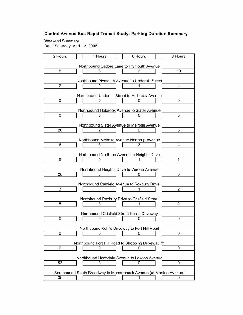
Central Avenue Bus Rapid Transit Study: Parking Duration Summary
Northbound Sadore Lane to Plymouth Avenue
Northbound Plymouth Avenue to Underhill Street
Northbound Underhill Street to Holbrook Avenue
Weekday Summary
Date: Wednesday, April 2, 2008
Northbound Holbrook Avenue to Slater Avenue
Northbound Slater Avenue to Melrose Avenue
Northbound Melrose Avenue Northrup Avenue
Northbound Northrup Avenue to Heights Drive
Northbound Heights Drive to Verona Avenue
Northbound Canfield Avenue to Roxbury Drive
Northbound Roxbury Drive to Crisfield Street
Northbound Crisfield Street Kohl's Driveway
Southbound South Broadway to Mamaroneck Avenue (at Martine Avenue)
0 0
Northbound Hartsdale Avenue to Lawton Avenue
36 4
Northbound Kohl's Driveway to Fort Hill Road
Northbound Fort Hill Road to Shopping Driveway #1
1 0 0 0
00135
0000
0000
0000
322
4313
23318
195
0328
1 02
0 0 0 0
30 2
57
2 Hours 4 Hours 6 Hours 8 Hours
8
1
4
4
11
2

Central Avenue Bus Rapid Transit Study: Parking Duration Summary
Weekday Summary
Date: Wednesday, April 2, 2008
2 Hours 4 Hours 6 Hours 8 Hours
Southbound Mamaroneck Avenue to Court Street (at Martine Avenue)
Southbound Lawton Avenue to Hartsdale Avenue
Southbound Clifton Road to Shopping Driveway #5
Southbound Shopping Drivewawy #5 to Shopping Driveway #4
Southbound Shopping Driveway #4 to Shopping Drivewway #3
Southbound Shopping Driveway #3 to Shopping Driveway #2
0 0 0 0
Southbound Shopping Driveway #2 to Shopping Driveway #1
Southbound Shopping Driveway #1 to Fort Hill Road
Southbound Fort Hill Road to Kohl's Driveway
Southbound Kohl's Driveway to Crisfield Street
Southbound Crisfield Street to Roxbury Drive
Southbound Roxbury Drive to Alta Vista Drive
Southbound Alta Vista Drive to Verona Avenue
Southbound Verona Avenue to Heights Drive
3
0 0 0 0
Southbound Heights Drive to Northrup Avenue
3128
81 3
834 0
21398
0000
0000
0021
017
1 0 1 0
000
0
0
0003
4 0 0 0
0 0 0
4

Central Avenue Bus Rapid Transit Study: Parking Duration Summary
Weekday Summary
Date: Wednesday, April 2, 2008
2 Hours 4 Hours 6 Hours 8 Hours
Total: 222 63 80 51
3 0 0 0
Southbound Northrup Avenue to Melrose Avenue
Southbound Melrose Avenue to Underhill Street
Southbound Underhill Street to Balint Drive
Southbound Balint Drive to Sadore Lane
Southbound Cowles Avenue to Yonkers
Southbound Yonker Avenue to Allen Street
Southbound Allen Street to Boone Street
0
41322
0 07 1
0
00011
0 0 0 0
0000
034
815621
Southbound Boone Street to Clark Street
Southbound Sanford Street to McLean Avenue
13
4 0

10
3
2
6
5
17
2 Hours 4 Hours 6 Hours 8 Hours
4 5
3 0 3
0 0 0 0
0 2 0
01413
7 6 1
01122
5 0 4 2
2 3 0
0 0 0 0
0000
00 00
22 4 3 0
6 0 0 0
2 0
Northbound Hartsdale Avenue to Lawton Avenue
36 2
Northbound Kohl's Driveway to Fort Hill Road
Northbound Fort Hill Road to Shopping Driveway #1
Southbound South Broadway to Mamaroneck Avenue (at Martine Avenue)
Northbound Heights Drive to Verona Avenue
Northbound Canfield Avenue to Roxbury Drive
Northbound Roxbury Drive to Crisfield Street
Northbound Crisfield Street Kohl's Driveway
Northbound Holbrook Avenue to Slater Avenue
Northbound Slater Avenue to Melrose Avenue
Northbound Melrose Avenue Northrup Avenue
Northbound Northrup Avenue to Heights Drive
Central Avenue Bus Rapid Transit Study: Parking Duration Summary
Northbound Sadore Lane to Plymouth Avenue
Northbound Plymouth Avenue to Underhill Street
Northbound Underhill Street to Holbrook Avenue
Weekday Summary
Date: Thursday, April 3, 2008

2 Hours 4 Hours 6 Hours 8 Hours
Central Avenue Bus Rapid Transit Study: Parking Duration Summary
Weekday Summary
Date: Thursday, April 3, 2008
0
1
0 0
2 0 0 0
02 00
0
0 0 0 0
2 0 1 0
1 3 0
0 0 1 1
0 0 0 0
0 0 0 0
11 8 11 3
4 11 7
6 2 4
3 4 5 0
Southbound Heights Drive to Northrup Avenue
0 0 0 0
3
Southbound Crisfield Street to Roxbury Drive
Southbound Roxbury Drive to Alta Vista Drive
Southbound Alta Vista Drive to Verona Avenue
Southbound Verona Avenue to Heights Drive
Southbound Shopping Driveway #2 to Shopping Driveway #1
Southbound Shopping Driveway #1 to Fort Hill Road
Southbound Fort Hill Road to Kohl's Driveway
Southbound Kohl's Driveway to Crisfield Street
Southbound Clifton Road to Shopping Driveway #5
Southbound Shopping Drivewawy #5 to Shopping Driveway #4
Southbound Shopping Driveway #4 to Shopping Drivewway #3
Southbound Shopping Driveway #3 to Shopping Driveway #2
0 0 0 0
Southbound Mamaroneck Avenue to Court Street (at Martine Avenue)
Southbound Lawton Avenue to Hartsdale Avenue

2 Hours 4 Hours 6 Hours 8 Hours
Central Avenue Bus Rapid Transit Study: Parking Duration Summary
Weekday Summary
Date: Thursday, April 3, 2008
Total 227 54 87 33
02
9
Southbound Boone Street to Clark Street
Southbound Sanford Street to McLean Avenue
18 3 20 4
5 1 2
0 0 0 0
0 0 0 0
9 0 00
0
6 0 0 0
7 0 16 1
Southbound Balint Drive to Sadore Lane
Southbound Cowles Avenue to Yonkers
Southbound Yonkers Avenue to Allen Street
Southbound Allen Street to Boone Street
0
Southbound Northrup Avenue to Melrose Avenue
Southbound Melrose Avenue to Underhill Street
Southbound Underhill Street to Balint Drive
4 0 0 0
Central Avenue Bus Rapid Transit Study: Parking Duration Summary
Northbound Sadore Lane to Plymouth Avenue
Northbound Plymouth Avenue to Underhill Street
Northbound Underhill Street to Holbrook Avenue
Weekend Summary
Date: Saturday, April 12, 2008
Northbound Holbrook Avenue to Slater Avenue
Northbound Slater Avenue to Melrose Avenue
Northbound Melrose Avenue Northrup Avenue
Northbound Northrup Avenue to Heights Drive
Northbound Heights Drive to Verona Avenue
Northbound Canfield Avenue to Roxbury Drive
Northbound Roxbury Drive to Crisfield Street
Northbound Crisfield Street Kohl's Driveway
Southbound South Broadway to Mamaroneck Avenue (at Martine Avenue)
0 0
Northbound Hartsdale Avenue to Lawton Avenue
53 3
Northbound Kohl's Driveway to Fort Hill Road
Northbound Fort Hill Road to Shopping Driveway #1
5 0 1 1
01435
0000
0000
0000
213
2113
00326
433
52220
0 30
0 0 0 0
40 1
103
2 Hours 4 Hours 6 Hours 8 Hours
8
5
5
2
6
0
Central Avenue Bus Rapid Transit Study: Parking Duration Summary
Weekend Summary
Date: Saturday, April 12, 2008
2 Hours 4 Hours 6 Hours 8 Hours
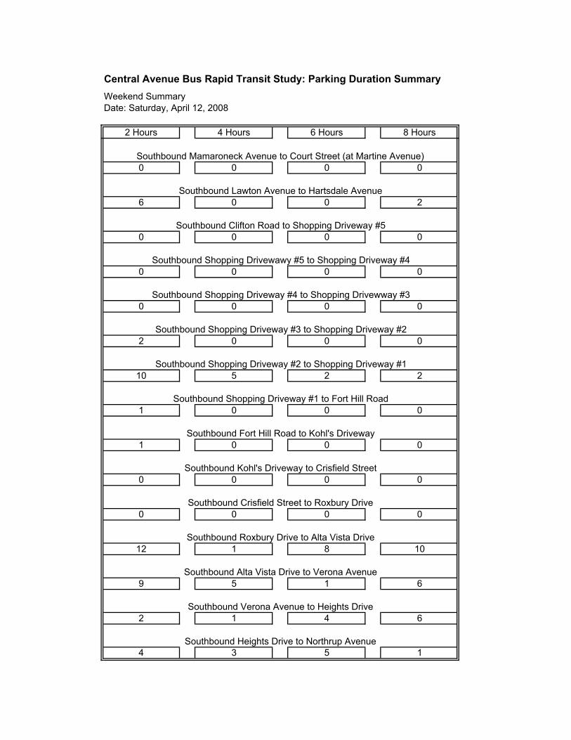
Southbound Mamaroneck Avenue to Court Street (at Martine Avenue)
Southbound Lawton Avenue to Hartsdale Avenue
Southbound Clifton Road to Shopping Driveway #5
Southbound Shopping Drivewawy #5 to Shopping Driveway #4
Southbound Shopping Driveway #4 to Shopping Drivewway #3
Southbound Shopping Driveway #3 to Shopping Driveway #2
0 0 0 0
Southbound Shopping Driveway #2 to Shopping Driveway #1
Southbound Shopping Driveway #1 to Fort Hill Road
Southbound Fort Hill Road to Kohl's Driveway
Southbound Kohl's Driveway to Crisfield Street
Southbound Crisfield Street to Roxbury Drive
Southbound Roxbury Drive to Alta Vista Drive
Southbound Alta Vista Drive to Verona Avenue
Southbound Verona Avenue to Heights Drive
1
1 0 0 0
Southbound Heights Drive to Northrup Avenue
1534
62 4
659 1
108112
0000
0000
0001
225
2 0 0 0
000
0
0
2006
0 0 0 0
0 0 0
10

Central Avenue Bus Rapid Transit Study: Parking Duration Summary
Weekend Summary
Date: Saturday, April 12, 2008
2 Hours 4 Hours 6 Hours 8 Hours
Total:
6 1 0 0
Southbound Northrup Avenue to Melrose Avenue
Southbound Melrose Avenue to Underhill Street
Southbound Underhill Street to Balint Drive
Southbound Balint Drive to Sadore Lane
Southbound Cowles Avenue to Yonkers
Southbound Yonker Avenue to Allen Street
Southbound Allen Street to Boone Street
0
1045
0 08 2
0
00015
0 0 0 0
0000
430
107610
Southbound Boone Street to Clark Street
Southbound Sanford Street to McLean Avenue
10
6 0
270 52 43 73

2
2
0
8
1
9
2 Hours 4 Hours 6 Hours 8 Hours
2 5
1 1 3
0 0 0 0
0 0 0
1018
2 1 1
00314
5 7 1 0
1 2 3
0 0 0 0
0000
00 00
20 4 4 1
3 0 0 0
2 3
Northbound Hartsdale Avenue to Lawton Avenue
62 4
Northbound Kohl's Driveway to Fort Hill Road
Northbound Fort Hill Road to Shopping Driveway #1
Southbound South Broadway to Mamaroneck Avenue (at Martine Avenue)
Northbound Heights Drive to Verona Avenue
Northbound Canfield Avenue to Roxbury Drive
Northbound Roxbury Drive to Crisfield Street
Northbound Crisfield Street Kohl's Driveway
Northbound Holbrook Avenue to Slater Avenue
Northbound Slater Avenue to Melrose Avenue
Northbound Melrose Avenue Northrup Avenue
Northbound Northrup Avenue to Heights Drive
Central Avenue Bus Rapid Transit Study: Parking Duration Summary
Northbound Sadore Lane to Plymouth Avenue
Northbound Plymouth Avenue to Underhill Street
Northbound Underhill Street to Holbrook Avenue
Weekend Summary
Date: Sunday, April 13, 2008

2 Hours 4 Hours 6 Hours 8 Hours
Central Avenue Bus Rapid Transit Study: Parking Duration Summary
Weekend Summary
Date: Sunday, April 13, 2008
0
9
0 0
0 0 0 0
15 10
0
0 0 0 0
0 0 0 0
4 0 0
2 1 0 1
0 0 0 0
0 0 0 0
0 0 1 0
4 46 7
6 0 0
0 0 2 1
Southbound Heights Drive to Northrup Avenue
0 0 0 0
0
Southbound Crisfield Street to Roxbury Drive
Southbound Roxbury Drive to Alta Vista Drive
Southbound Alta Vista Drive to Verona Avenue
Southbound Verona Avenue to Heights Drive
Southbound Shopping Driveway #2 to Shopping Driveway #1
Southbound Shopping Driveway #1 to Fort Hill Road
Southbound Fort Hill Road to Kohl's Driveway
Southbound Kohl's Driveway to Crisfield Street
Southbound Clifton Road to Shopping Driveway #5
Southbound Shopping Drivewawy #5 to Shopping Driveway #4
Southbound Shopping Driveway #4 to Shopping Drivewway #3
Southbound Shopping Driveway #3 to Shopping Driveway #2
0 0 0 0
Southbound Mamaroneck Avenue to Court Street (at Martine Avenue)
Southbound Lawton Avenue to Hartsdale Avenue

2 Hours 4 Hours 6 Hours 8 Hours
Central Avenue Bus Rapid Transit Study: Parking Duration Summary
Weekend Summary
Date: Sunday, April 13, 2008
Total:
14
11
Southbound Boone Street to Clark Street
Southbound Sanford Street to McLean Avenue
3 6 4 8
2 1 0
0 0 0 0
0 0 0 0
9 0 00
0
2 3 0 0
2 4 0 0
Southbound Balint Drive to Sadore Lane
Southbound Cowles Avenue to Yonkers
Southbound Yonkers Avenue to Allen Street
Southbound Allen Street to Boone Street
0
Southbound Northrup Avenue to Melrose Avenue
Southbound Melrose Avenue to Underhill Street
Southbound Underhill Street to Balint Drive
3 1 0 0
186 60 25 35
Top Related