


Languages
Pages
Legal


Case Study Presentation of the Downtown Brampton Flood Protection Class EA
Presented by:
Kenneth M. Dion, Project Director – Port Lands Integration,
Waterfront Toronto (formerly Senior Manager, TRCA)
At: OAIA 2018 Conference, Planning and Protecting Water
Resources
October 17, 2018

Presentation Outline
• Project overview
• Problems and Opportunities
• Key challenges
• EA approach
• Coordinated planning
Toronto and Region Conservation Authority 2
The information contained in this presentation is copyright © Toronto and Region Conservation Authority

Project overview – Parallel project planning and co-proponency
Toronto and Region Conservation Authority 3
Downtown Brampton Flood Protection Project EA (DBFP EA) is a critical first, foundational step toward
achieving the City of Brampton’s Riverwalk Project and contribute to the larger Brampton 2040 Vision.
While the DBFP EA is focused on providing a flood protection solution to Downtown Brampton, it will
consider, be informed by, and work in parallel with the City’s Riverwalk project.
Given the confluence of jurisdiction, expertise and land ownership, the DBFP EA is being undertaken
as a co-proponency between the Toronto and Region Conservation Authority (TRCA) and the City of
Brampton.
Dominion Skate Development (2018 to 2022)
Ryerson Academic Building (2020 to 2022)
Centre for Innovation (2020 to 2023)
Metrolinx Surface Parking Lot (2018 to 2020)
Heritage Theatre Block (2020 to 2022)
Rose Garden Residences (Post 2022)
Downtown Reimagined (2019/20 to 2022)
Similar foundational, parallel planning approaches
have been undertaken by TRCA and Waterfront in the
West Don Lands and Lower Don Lands, whereby the
development of a preferred alternative for flood
protection formed the basis for community
intensification and revitalization.

Toronto and Region Conservation Authority 4
Project overview – Regional context
Brampton

Existing flood protection (a concrete-lined bypass
channel), cannot convey the current Regulatory
Flood nor accommodate potential increases in
flooding due to climate or upstream land use
change.
DBFP will consider alternatives to remove existing
flood risk and provide additional capacity to
address uncertainty in order to unlock the
potential for revitalization of the Downtown Core.
Project overview – Study location
bypass channel
In Ontario, this is the extent of the
floodplain that is used to regulate
development and define risk. It is
based on rainfall from Hurricane
Hazel – the largest storm of record
in the area.
Regulatory Flood

Toronto and Region Conservation Authority 6
Historically, Downtown Brampton experienced frequent flooding until a
concrete by-pass channel was built, in 1952.
600m long, the by-pass channel conveys flows from Church St
downstream to Centennial Park.
The by-pass channel played a major role in preventing significant damage,
and loss of life in downtown Brampton during Hurricane Hazel in 1954.
Despite the by-pass channel, 31 hectares of downtown Brampton remain
vulnerable to flooding during the regulatory flood event.
Project overview – A history of flooding Downtown Brampton

Toronto and Region Conservation Authority 7
Project overview – Flooding and the SPAA Special Policy Area (SPA) acknowledges that
development already exists in a flood vulnerable area
and that to prevent any new expansion of existing uses
could negatively impact the local economy.
While the SPA will not allow for land use intensification,
it does provide flexibility for individual land owners to
use and expand their existing uses by a finite amount,
often with lot-specific flood-proofing measures.
This is the
natural path of
the river before it
was relocated
Here is the
by-pass
channel
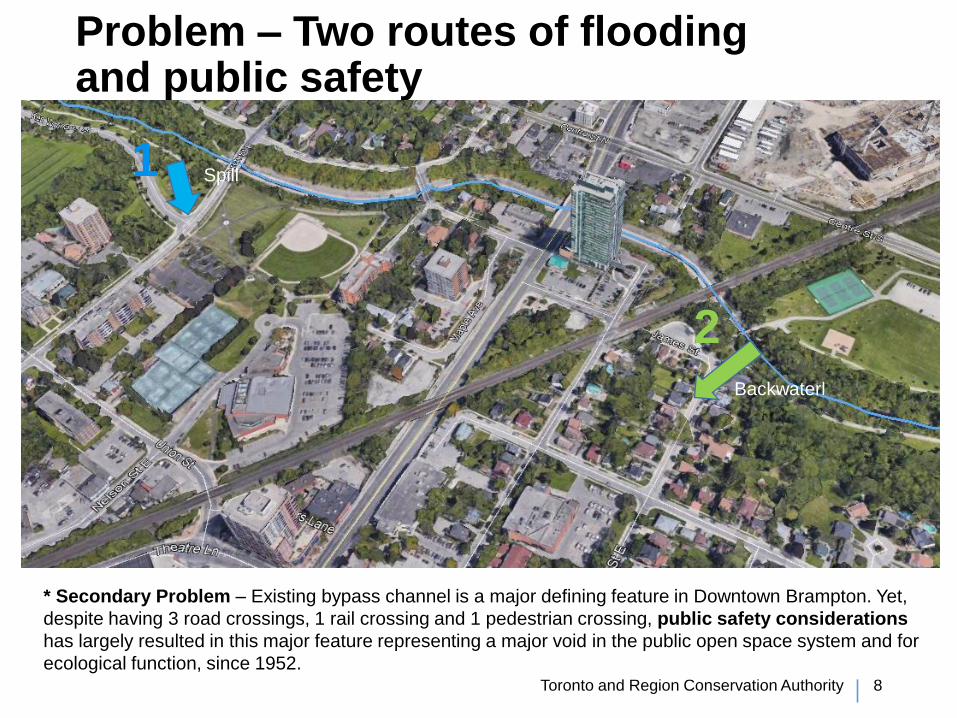
Problem – Two routes of flooding and public safety
Toronto and Region Conservation Authority 8
Spill 1
2 Backwaterl
* Secondary Problem – Existing bypass channel is a major defining feature in Downtown Brampton. Yet,
despite having 3 road crossings, 1 rail crossing and 1 pedestrian crossing, public safety considerations
has largely resulted in this major feature representing a major void in the public open space system and for
ecological function, since 1952.

Toronto and Region Conservation Authority 9
Opportunity – Alleviating existing flood risk and facilitating intensification
NOW - 31 hectares of land at risk to flooding currently includes residential, commercial, and institutional land uses, including City Hall.
• Flood protection would alleviate risk to many of these existing areas.
FUTURE - Development is restricted in Downtown Brampton because of flood risk.
• Removing flood risk to areas within the SPA allows for revitalization of the downtown core
Riverwalk Parallel Planning Opportunity –Consideration of flood protection options, will also provide opportunities to reconnect the public with the river, to enhance associated open spaces and to improve ecological function.
• Opportunities will be fully explored in the broader, parallel Downtown Brampton Riverwalk Planning process.

Toronto and Region Conservation Authority 10
Key challenges – a legacy of infrastructure and land use
Development and evaluation of alternatives must consider:
1) Existing roads, rail and bridges in the area
2) Future construction plans in development for bridges and transit, including the railway corridor
3) Existing stormsewers, sanitary sewers, watermains and utilities in the area
4) Historical waste disposal areas
5) Existing parks, open spaces and ecological areas
6) How to modify existing concrete bypass channel while maintaining current levels of flood protection during construction
7) Identified heritage resources within the Study Location, including a cemetery
8) City of Brampton aspirations for the Riverwalk project and Brampton 2040 Vision

Toronto and Region Conservation Authority 11
Spring/
Summer 2019Fall 2019-
Winter 2020?Fall 2019 –
Winter 2020Fall 2018
Municipal Class EA
• Vast majority of works required for achieving flood protection involve the
planning, modification, or relocation of existing or municipal infrastructure.
• While opportunities will be provided for public realm, open space and ecological
enhancements, those will be defined in the parallel, broader scoped, Riverwalk
planning process led by the City of Brampton.
• Thus, the DBFP will be undertaken using a ‘Schedule C’ procedures pursuant to
the Municipal Class EA
We are
here

Toronto and Region Conservation Authority 12
Coordinated planning processDBFP Class EA
• Consolidate findings of past hydraulic modeling feasibility studies
• Define a reasonable short list of alternative solutions from work completed to date
• Develop evaluation criteria to select a preliminary preferred solution
• Select preliminary preferred solution
• City of Brampton Riverwalk Process initiates on basis of preliminary preferred solution
• Design Alternatives are developed the Riverwalk team based on preliminary preferred solution, with input from DBFP team
• DBFP team further refines evaluation criteria to reflect Alternative Design details
• Select preferred design alternative for flood protection for the DBFP EA
• City of Brampton Riverwalk process continues to refine public realm design elements and brings into the broader design process for the rest of the Downtown Brampton.
• The DBFP EA team develops and submits the ESR for approval.
* NOTE: coordinated public, stakeholder, agency and Indigenous engagement will be provided throughout the EA process.
External Project Coordination
Planning in the Downtown Brampton area is extensive. DBFP team will also work with the following agencies and their associated projects:
• Metrolinx – railway corridor expansion
• City of Brampton – light rapid transit planning
• City of Brampton – Ken Willans Class EA
• City of Brampton – Official Plan and Secondary Plan updates

www.trca.ca
Thank you
Top Related