


Languages
Pages
Legal


Building on A Foundation of Excellence
Pennsylvania Environmental Council
East Coast Greenway Bridge Street Obstruc�on Gilmore & Associates, Inc.
Engineering & Consulting Services
PENNSYLVANIA ENVIRONMENTAL COUNCIL
EAST COAST GREENWAY BRIDGE STREET OBSTRUCTION
TABLE of CONTENTS
SECTION 1 FEASIBILITY MEMO
SECTION 2 CONCEPT SKETCH
SECTION 3 OPINION OF PROBABLE COST
SECTION 4 PERSPECTIVE SKETCHES
SECTION 5 SECONDARY TRAIL ACCESS DIAGRAM
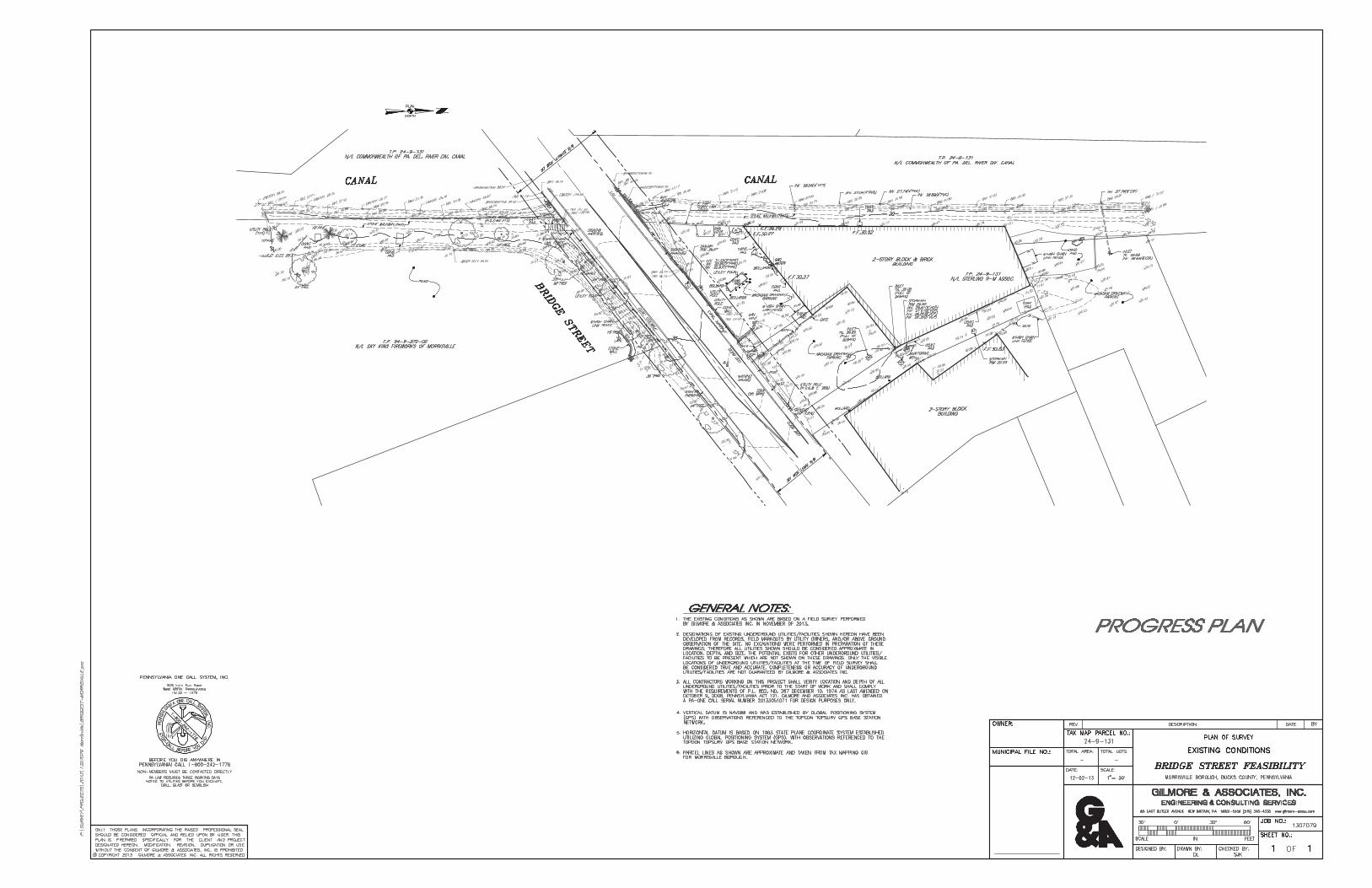
APPENDIX A SITE SURVEY
APPENDIX B PRELIMINARY SITE INVENTORY, OPPORTUNITES AND CONTRAINTS (OCTOBER 9, 2013)
APPENDIX C DCNR LEGAL ASPECTS OF CANAL OWNERSHIP
APPENDIX D PDNI ENVIRONMENTAL REVIEW RECEIPT
Building on A Foundation of Excellence
Pennsylvania Environmental Council
East Coast Greenway Bridge Street Obstruc�on Gilmore & Associates, Inc. Engineering & Consulting Services
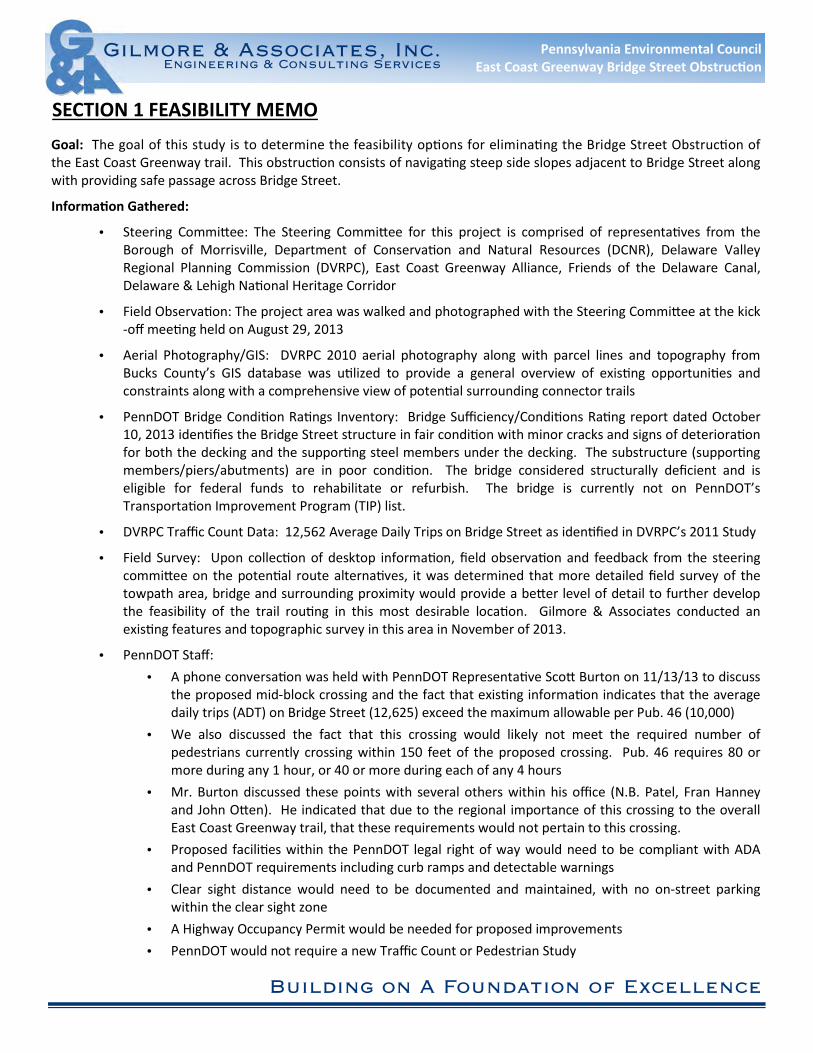
SECTION 1 FEASIBILITY MEMO
Goal: The goal of this study is to determine the feasibility op�ons for elimina�ng the Bridge Street Obstruc�on of
the East Coast Greenway trail. This obstruc�on consists of naviga�ng steep side slopes adjacent to Bridge Street along
with providing safe passage across Bridge Street.
Informa�on Gathered:
• Steering Commi!ee: The Steering Commi!ee for this project is comprised of representa�ves from the
Borough of Morrisville, Department of Conserva�on and Natural Resources (DCNR), Delaware Valley
Regional Planning Commission (DVRPC), East Coast Greenway Alliance, Friends of the Delaware Canal,
Delaware & Lehigh Na�onal Heritage Corridor
• Field Observa�on: The project area was walked and photographed with the Steering Commi!ee at the kick
-off mee�ng held on August 29, 2013
• Aerial Photography/GIS: DVRPC 2010 aerial photography along with parcel lines and topography from
Bucks County’s GIS database was u�lized to provide a general overview of exis�ng opportuni�es and
constraints along with a comprehensive view of poten�al surrounding connector trails
• PennDOT Bridge Condi�on Ra�ngs Inventory: Bridge Sufficiency/Condi�ons Ra�ng report dated October
10, 2013 iden�fies the Bridge Street structure in fair condi�on with minor cracks and signs of deteriora�on
for both the decking and the suppor�ng steel members under the decking. The substructure (suppor�ng
members/piers/abutments) are in poor condi�on. The bridge considered structurally deficient and is
eligible for federal funds to rehabilitate or refurbish. The bridge is currently not on PennDOT’s
Transporta�on Improvement Program (TIP) list.
• DVRPC Traffic Count Data: 12,562 Average Daily Trips on Bridge Street as iden�fied in DVRPC’s 2011 Study
• Field Survey: Upon collec�on of desktop informa�on, field observa�on and feedback from the steering
commi!ee on the poten�al route alterna�ves, it was determined that more detailed field survey of the
towpath area, bridge and surrounding proximity would provide a be!er level of detail to further develop
the feasibility of the trail rou�ng in this most desirable loca�on. Gilmore & Associates conducted an
exis�ng features and topographic survey in this area in November of 2013.
• PennDOT Staff:
• A phone conversa�on was held with PennDOT Representa�ve Sco! Burton on 11/13/13 to discuss
the proposed mid-block crossing and the fact that exis�ng informa�on indicates that the average
daily trips (ADT) on Bridge Street (12,625) exceed the maximum allowable per Pub. 46 (10,000)
• We also discussed the fact that this crossing would likely not meet the required number of
pedestrians currently crossing within 150 feet of the proposed crossing. Pub. 46 requires 80 or
more during any 1 hour, or 40 or more during each of any 4 hours
• Mr. Burton discussed these points with several others within his office (N.B. Patel, Fran Hanney
and John O!en). He indicated that due to the regional importance of this crossing to the overall
East Coast Greenway trail, that these requirements would not pertain to this crossing.
• Proposed facili�es within the PennDOT legal right of way would need to be compliant with ADA
and PennDOT requirements including curb ramps and detectable warnings
• Clear sight distance would need to be documented and maintained, with no on-street parking
within the clear sight zone
• A Highway Occupancy Permit would be needed for proposed improvements
• PennDOT would not require a new Traffic Count or Pedestrian Study

Building on A Foundation of Excellence
Pennsylvania Environmental Council
East Coast Greenway Bridge Street Obstruc�on Gilmore & Associates, Inc. Engineering & Consulting Services
Op�ons Explored:
• Delmorr Avenue Route: U�lize exis�ng sidewalk network for pedestrians and Shared Road route for
experienced cyclists. This route was dismissed by the steering commi!ee due to safety concerns and the
desire for the trail to con�nue along the canal towpath.
• Shared Accessway: U�lize shared accessway/alley adjacent to parcel 24-9-131 to avoid sloped
embankment on the north side of Bridge Street. This route presents several obstacles. The accessway is
only twenty feet in width and accommodates both ingress and egress for vehicles (two way traffic). This
does not leave adequate space to provide a ten foot wide trail route and accommodate two-way vehicular
traffic. In addi�on, exis�ng structures on both east and west sides of the accessway have garage bays
which create addi�onal conflict points for pedestrians. There is also an eleva�on change to the north of
the exis�ng depressed curb that would require ramping on private property. Easements would need to be
established with three separate property owners who rely on the alley for access to their proper�es. In
addi�on the accessway is located directly across from the exis�ng convenience store which would en�ce
pedestrians to cross Bridge Street at a hazardous loca�on where vehicles are making mul�ple turning
movements. Mid-Block Crossing improvements on Bridge Street as well as ramped access on the south
side of the street would also be necessary to complete the connec�on.
• Route Beneath Bridge Structure: Provide a route below the bridge structure to avoid conflict with
vehicular traffic traveling on Bridge Street. This route is infeasible at this �me. Field survey revealed that
there is approximately five feet six inches between the exis�ng towpath eleva�on and the bo!om of the
bridge structure. There is approximately eight feet six inches of eleva�on difference between the exis�ng
water surface eleva�on and the bo!om of the bridge structure. This exceeds the minimum clearance of
eight feet that is required by AASHTO, however there is a six inch gas pipeline that hangs beneath the
bridge structure, reducing the necessary clearance. Rou�ng beneath the bridge was also considered for
future poten�al bridge rehabilita�on or replacement, however such an improvement is not likely to be
implemented in the foreseeable future since it is not currently listed on PennDOT’s TIP priority list.
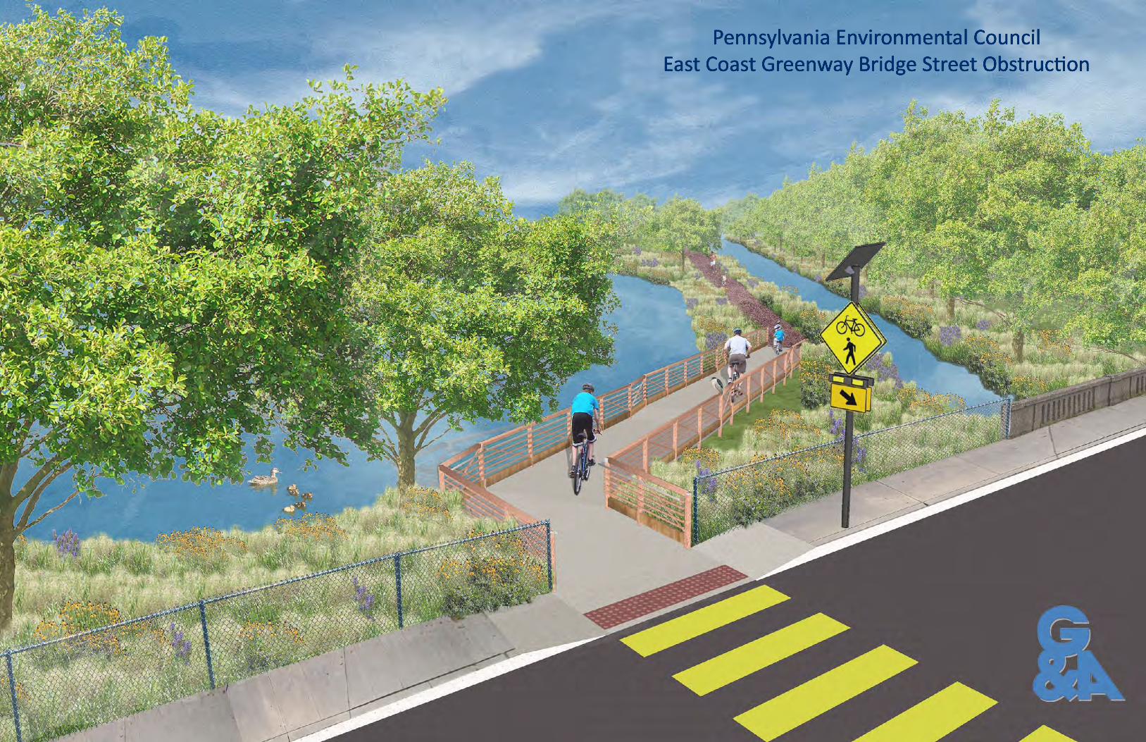
• Ramping with Mid-Block Crossing: Exis�ng Bridge Street eleva�on is approximately seven feet six inches
above the towpath eleva�on on both the north and south sides of Bridge Street. Provide an accessible
ramp system to transi�on to from Bridge Street to towpath. Implement a pedestrian/mo�on ac�vated
rectangular rapid flash beacon (RRFB) signal along with required signage and pavement markings to
provide a mid-block pedestrian crossing across Bridge Street.

Building on A Foundation of Excellence
Pennsylvania Environmental Council
East Coast Greenway Bridge Street Obstruc�on Gilmore & Associates, Inc. Engineering & Consulting Services
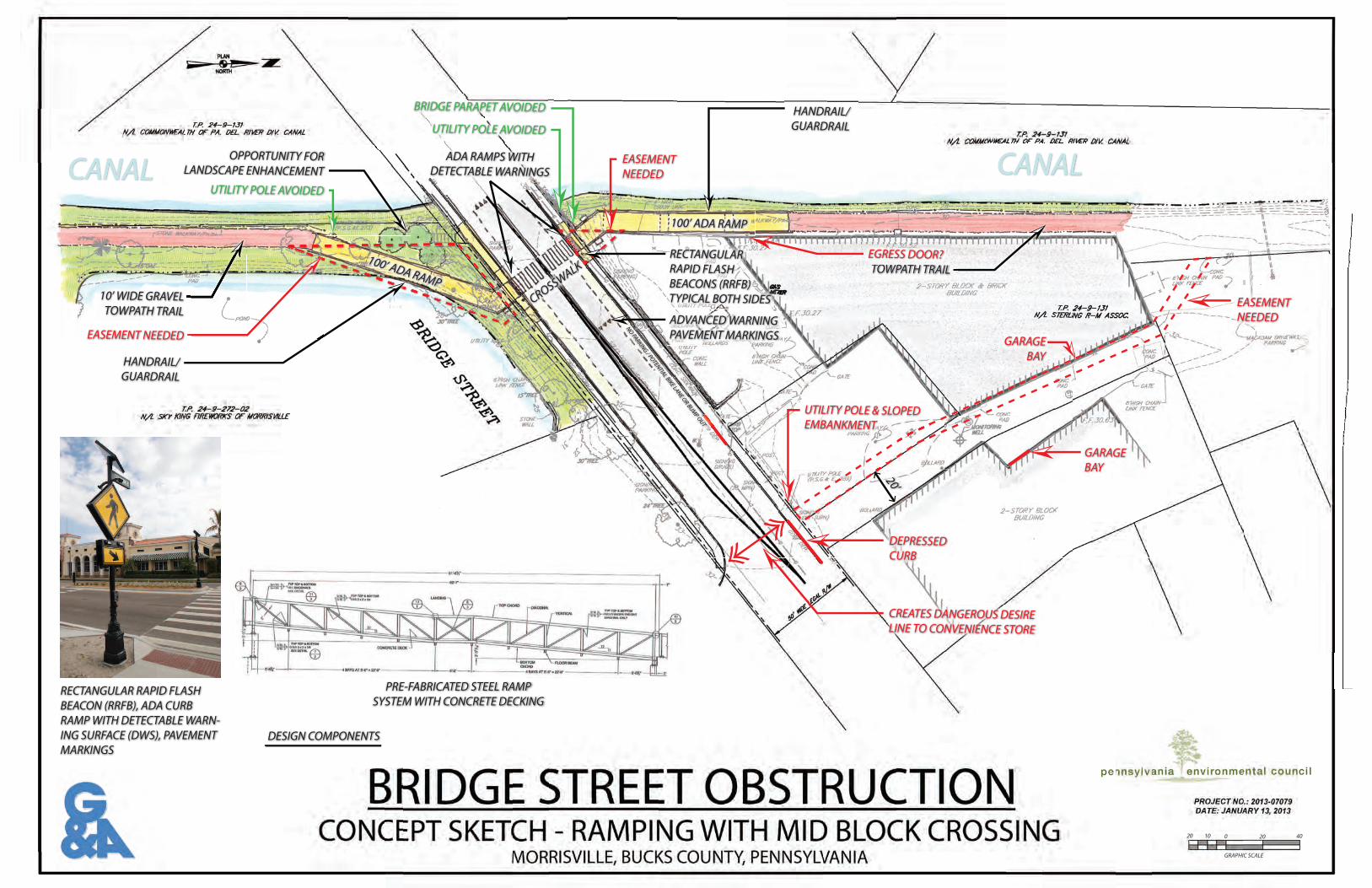
Recommenda�ons:
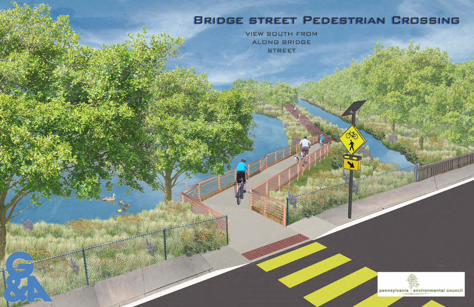
We believe that the most feasible route to pursue is the ramping with mid-block crossing op�on. The conceptual
sketch plan that has been prepared includes the following components:
• Two ramped structures (one on north side of Bridge Street and one on the south side). Ramps will be one
hundred feet in length to accommodate the grade change between Bridge Street and the towpath. The
ramp structure on the north side is angled so that it avoids the exis�ng u�lity pole and bridge parapet.
The ramp structure on the south side is angled so that it avoids the exis�ng u�lity pole and provides views
of the exis�ng pond.
• Mid-Block Pedestrian Road Crossing. Crossing of Bridge Street (State Route 0032) will require the approval
of PennDOT for improvements within the legal right of way. An�cipated improvements include
construc�on of curb ramps with detectable warnings, crosswalk and advanced warning markings,
rectangular rapid flash beacon signal. No on street parking will be allowable within the clear sight
distances that are required at the crossing.
Advantages of this op�on include:
• Favorable to Steering Commi!ee
• Limited number and size of required Easements
• Poten�al economic benefit for Morrisville Borough due to bringing the trail up to street level
• Simplified Construc�on & Small Disturbance Envelope/limited impact to adjacent property owners with
use of Pre-fabricated Metal Ramp Structure.
• Layout to avoid switchback ramping configura�on – bicycle friendly
• Ability to complete construc�on (pending funding) within the �meframe of other improvements to the
East Coast Greenway.
• Avoid conflicts with exis�ng u�li�es.
• Avoid conflicts with exis�ng bridge abutment and bridge parapet.
Addi�onal Opportuni�es:
In addi�on to the recommended rou�ng op�on described above, we believe there are addi�onal opportuni�es to
connect to the East Coast Greenway/D&L Trail through various connector trails. Opportuni�es include:
• Create/Strengthen pedestrian and bike routes from the Bridge Street crossing heading east across the
bridge into New Jersey. Bridge Street transi�ons into Warren Street in New Jersey and contains bike lanes.
Warren Street connects to the Capitol Complex, which is a hub of pedestrian ac�vity. Connec�vity to the
D&R trail is also an important pedestrian link in New Jersey.
• Improve connec�vity and accessibility from the Williamson Park parking lot to the D&L towpath trail via
Hillside Avenue and East Palmer Street. The parking lot is designated as a Trail Head on D&L’s website.
NO
PARKIN
G / PO
TENTIA
L BIKE LAN
E OR BU
MP O
UT
OPPORTUNITY FOR
LANDSCAPE ENHANCEMENT
100’ ADA RAMP
CROSSWALK
100’ ADA RAMP
20’
UTILITY POLE AVOIDED
UTILITY POLE AVOIDED
BRIDGE PARAPET AVOIDED HANDRAIL/
GUARDRAIL
HANDRAIL/
GUARDRAIL
RECTANGULAR
RAPID FLASH
BEACONS (RRFB)
TYPICAL BOTH SIDES
TOWPATH TRAIL
/
10’ WIDE GRAVEL
TOWPATH TRAIL
EASEMENT NEEDED
EASEMENT
NEEDED
EASEMENT
NEEDED
DEPRESSED
CURB
UTILITY POLE & SLOPED
EMBANKMENT
CREATES DANGEROUS DESIRE
LINE TO CONVENIENCE STORE
TTOOWWPPAATTHH TTRRAAIILLTO
EGRESS DOOR?
ADA RAMPS WITH
DETECTABLE WARNINGS
ADVANCED WARNING
PAVEMENT MARKINGS
RECTANGULAR RAPID FLASH
BEACON (RRFB), ADA CURB
RAMP WITH DETECTABLE WARN-
ING SURFACE (DWS), PAVEMENT
MARKINGS
PRE-FABRICATED STEEL RAMP
SYSTEM WITH CONCRETE DECKING
DESIGN COMPONENTS
20 0 20
GRAPHIC SCALE
4010
GARAGE
BAY
GARAGE
BAY

Building on A Foundation of Excellence
Pennsylvania Environmental Council
East Coast Greenway Bridge Street Obstruc�on Gilmore & Associates, Inc.
Engineering & Consulting Services
SECTION 3 OPINION OF PROBABLE COSTS
PRELIMINARY COST OPINION WORKSHEET
(BASED ON RESTRICTIVE GRANT FUNDING)
PROJECT: East Coast Greenway - Bridge Street Obstruc�on 20-Jan-14
LOCATION: BOROUGH OF MORRISVILLE, BUCKS COUNTY, PA
DESCRIPTION: RAMPED APPROACH AND MID-BLOCK CROSSING
ITEM TOTAL
NO. DESCRIPTION NO. UNIT $/UNIT COST
SITE PREPARATION
1 MOBILIZATION 1 L.S. $50,000.00 $50,000.00
2 MAINTENANCE & PROTECTION OF TRAFFIC 1 L.S. $15,000.00 $15,000.00
3 EROSION & SEDIMENTATION CONTROL 1 L.S. $1,000.00 $1,000.00
4 TREE REMOVAL 1 L.S. $2,000.00 $2,000.00
TOTAL - SITE PREPARATION $68,000
RAMP CONSTRUCTION
1 CONCRETE BRIDGE ABUTMENTS/FOUNDATIONS 2 L.S. $35,000.00 $70,000.00
2 PREFABRICATED STEEL TRUSS RAMP 2 L.S. $200,000.00 $400,000.00
3 CONCRETE WALKING SURFACE (6" THICK) 225 SY $65.00 $14,625.00
4 CONCRETE TRANSITION 15 SY $65.00 $975
TOTAL - RAMP CONSTRUCTION $485,600
MID-BLOCK CROSSING
1 HANDICAP RAMP W/ DETECTABLE WARNING 2 EA. $6,000.00 $12,000
2 PAVEMENT MARKINGS (CONTINENTAL X-WALK) 1 LS $750 $750
3 PAVEMENT MARKINGS (ADVANCED WARNING) 2 EA. $250 $500
4 SOLAR RRFB SIGN/POLE 2 EA. $25,000 $50,000
5 BIKE/PED X-ING SIGNAGE (W11-15) 2 EA. $200 $400
TOTAL - MID-BLOCK CROSSING $63,650
AMENITIES
1 LANDSCAPE MATERIAL 1 L.S. $1,500 $1,500
2 WAY-FINDING SIGNAGE 2 EA. $200.00 $400
TOTAL - AMENITIES $1,900
SUB-TOTAL $619,150
CONTINGENCY (15%) $92,873
ENGINEERING/DESIGN (20%) $123,830
CONSTRUCTION ADMINISTRATION (15%)* $92,873
TOTAL COST $835,853
Building on A Foundation of Excellence
Pennsylvania Environmental Council
East Coast Greenway Bridge Street Obstruc�on Gilmore & Associates, Inc. Engineering & Consulting Services
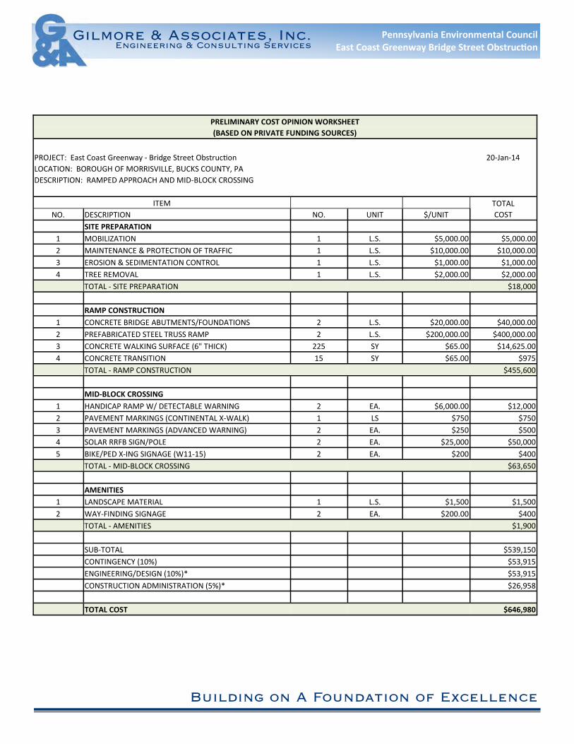
PRELIMINARY COST OPINION WORKSHEET
(BASED ON PRIVATE FUNDING SOURCES)
PROJECT: East Coast Greenway - Bridge Street Obstruc�on 20-Jan-14
LOCATION: BOROUGH OF MORRISVILLE, BUCKS COUNTY, PA
DESCRIPTION: RAMPED APPROACH AND MID-BLOCK CROSSING
ITEM TOTAL
NO. DESCRIPTION NO. UNIT $/UNIT COST
SITE PREPARATION
1 MOBILIZATION 1 L.S. $5,000.00 $5,000.00
2 MAINTENANCE & PROTECTION OF TRAFFIC 1 L.S. $10,000.00 $10,000.00
3 EROSION & SEDIMENTATION CONTROL 1 L.S. $1,000.00 $1,000.00
4 TREE REMOVAL 1 L.S. $2,000.00 $2,000.00
TOTAL - SITE PREPARATION $18,000
RAMP CONSTRUCTION
1 CONCRETE BRIDGE ABUTMENTS/FOUNDATIONS 2 L.S. $20,000.00 $40,000.00
2 PREFABRICATED STEEL TRUSS RAMP 2 L.S. $200,000.00 $400,000.00
3 CONCRETE WALKING SURFACE (6" THICK) 225 SY $65.00 $14,625.00
4 CONCRETE TRANSITION 15 SY $65.00 $975
TOTAL - RAMP CONSTRUCTION $455,600
MID-BLOCK CROSSING
1 HANDICAP RAMP W/ DETECTABLE WARNING 2 EA. $6,000.00 $12,000
2 PAVEMENT MARKINGS (CONTINENTAL X-WALK) 1 LS $750 $750
3 PAVEMENT MARKINGS (ADVANCED WARNING) 2 EA. $250 $500
4 SOLAR RRFB SIGN/POLE 2 EA. $25,000 $50,000
5 BIKE/PED X-ING SIGNAGE (W11-15) 2 EA. $200 $400
TOTAL - MID-BLOCK CROSSING $63,650
AMENITIES
1 LANDSCAPE MATERIAL 1 L.S. $1,500 $1,500
2 WAY-FINDING SIGNAGE 2 EA. $200.00 $400
TOTAL - AMENITIES $1,900
SUB-TOTAL $539,150
CONTINGENCY (10%) $53,915
ENGINEERING/DESIGN (10%)* $53,915
CONSTRUCTION ADMINISTRATION (5%)* $26,958
TOTAL COST $646,980


W. BRIDGE STREET
DEL
MO
RR A
VEN
UE
EXIS
TIN
G G
RAVE
L LE
VEE
TRAI
L
CEN
TER
STRE
ET
UNION STREET
PEN
NSY
LVAN
IA A
VEN
UE
WAS
HIN
GTO
N S
TREE
T
CEN
TRAL
AVE
NU
E
PARK
AVE
NU
E
D&L CANAL
D&L CANAL
WILLIAMSON PARK
D&L DESIGNATED TRAILHEAD
POTENTIAL IMPROVEMENTS:MMPRPROVOVEMEMENENTSTS::IM
- ADA PARKING SPACES-IMPROVED MID-BLOCK CROSSING-SIGNAGE
GOOGLE STREET VIEW IMAGE
TO NEW JERSEY(CONNECTION TO WARREN STREET
BIKE LANES)
250 125 0 250
NORTH
LEGEND
OFF ROAD TRAIL
DESIGNATED BIKE LANESPEDESTRIANS USE SIDEWALK
BIKES SHARE THE ROADPEDESTRIANS USE SIDEWALK
GOGOOGOG OGOGOGOGLELELELE SSSSTRTRTRTREEEEEEEETTTT VIVIVIVIEWEWEWEW IIIIMAMAMAMAGEGEGEGE
1
East Coast GreenwayBridge Street ObstructionFeasibility Study
Steering Committee MeetingPreliminary Site Inventory/Opportunities/ConstraintsOctober 9, 2013
Overall Trail Routing Potential
OPPORTUNITIES
• DIRECT ROUTE• INCORPORATE MID-BLOCK
CROSSING WITH RECTANGULAR RAPID FLASH BEACON
• COMPLETELY OFF-ROAD• POTENTIAL TO BE
INCORPORATED WITH FUTURE BRIDGE REPAIRS/RECONSTRUCTION
Bridge Street Bridge Improvements
CHALLENGES/CONSTRAINTS
• TIMING OF BRIDGE REPAIR (PENNDOT TRANSPORTATION IMPROVEMENT PROGRAM (T.I.P.))
• COST OF RAMPING STRUCTURES/BARRIERS
• COORDINATION/COOPERATION WITH ADJACENT PROPERTY OWNERS
Bridge Street Bridge Improvements
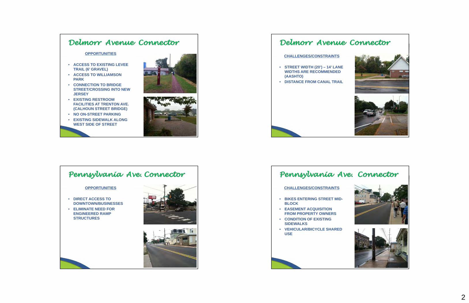
2
OPPORTUNITIES
• ACCESS TO EXISTING LEVEE TRAIL (6’ GRAVEL)
• ACCESS TO WILLIAMSON PARK
• CONNECTION TO BRIDGE STREET/CROSSING INTO NEW JERSEY
• EXISTING RESTROOM FACILITIES AT TRENTON AVE. (CALHOUN STREET BRIDGE)
• NO ON-STREET PARKING• EXISTING SIDEWALK ALONG
WEST SIDE OF STREET
Delmorr Avenue Connector
CHALLENGES/CONSTRAINTS
• STREET WIDTH (20’) – 14’ LANE WIDTHS ARE RECOMMENDED (AASHTO)
• DISTANCE FROM CANAL TRAIL
Delmorr Avenue Connector
OPPORTUNITIES
• DIRECT ACCESS TO DOWNTOWN/BUSINESSES
• ELIMINATE NEED FOR ENGINEERED RAMP STRUCTURES
Pennsylvania Ave. Connector
CHALLENGES/CONSTRAINTS
• BIKES ENTERING STREET MID-BLOCK
• EASEMENT ACQUISITION FROM PROPERTY OWNERS
• CONDITION OF EXISTING SIDEWALKS
• VEHICULAR/BICYCLE SHARED USE
Pennsylvania Ave. Connector
3
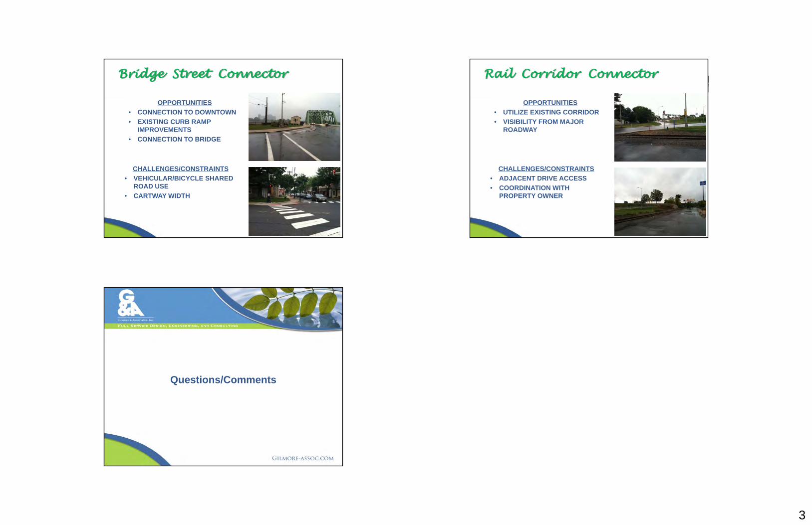
CHALLENGES/CONSTRAINTS• VEHICULAR/BICYCLE SHARED
ROAD USE• CARTWAY WIDTH
Bridge Street Connector
OPPORTUNITIES• CONNECTION TO DOWNTOWN• EXISTING CURB RAMP
IMPROVEMENTS• CONNECTION TO BRIDGE
CHALLENGES/CONSTRAINTS• ADJACENT DRIVE ACCESS• COORDINATION WITH
PROPERTY OWNER
Rail Corridor Connector
OPPORTUNITIES• UTILIZE EXISTING CORRIDOR• VISIBILITY FROM MAJOR
ROADWAY
Questions/Comments


PNDI Project Environmental Review Receipt Project Search ID: 20140108433369
Page 1 of 5
1. PROJECT INFORMATIONProject Name: Bridge Street ObstructionDate of review: 1/8/2014 12:13:36 PMProject Category: Recreation,Trails & Trailheads (parking, etc.)Project Area: 0.4 acresCounty: Bucks Township/Municipality: MorrisvilleQuadrangle Name: TRENTON WEST ~ ZIP Code: 19067Decimal Degrees: 40.207403 N, -74.776992 WDegrees Minutes Seconds: 40° 12' 26.7" N, -74° 46' 37.2" W
2. SEARCH RESULTSAgency Results ResponsePA Game Commission No Known Impact No Further Review Required
PA Department of Conservationand Natural Resources
Potential Impact FURTHER REVIEW IS REQUIRED,See Agency Response
PA Fish and Boat Commission Potential Impact FURTHER REVIEW IS REQUIRED,See Agency Response
U.S. Fish and Wildlife Service No Known Impact No Further Review Required
As summarized above, Pennsylvania Natural Diversity Inventory (PNDI) records indicate there may be potentialimpacts to threatened and endangered and/or special concern species and resources within the project area. Ifthe response above indicates "No Further Review Required" no additional communication with the respectiveagency is required. If the response is "Further Review Required" or "See Agency Response," refer to theappropriate agency comments below. Please see the DEP Information Section of this receipt if a PA Departmentof Environmental Protection Permit is required.

PNDI Project Environmental Review Receipt Project Search ID: 20140108433369
Page 2 of 5
Note that regardless of PNDI search results, projects requiring a Chapter 105 DEP individual permit or GP 5, 6,7, 8, 9 or 11 in certain counties (Adams, Berks, Bucks, Carbon, Chester, Cumberland, Delaware, Lancaster,Lebanon, Lehigh, Monroe, Montgomery, Northampton, Schuylkill and York) must comply with the bog turtlehabitat screening requirements of the PASPGP.
RESPONSE TO QUESTION(S) ASKEDQ1: "Accurately describe what is known about wetland presence in the project area or on the land parcel byselecting ONE of the following. ""Project"" includes all features of the project (including buildings, roads, utilitylines, outfall and intake structures, wells, stormwater retention/detention basins, parking lots, driveways, lawns,etc.), as well as all associated impacts (e.g., temporary staging areas, work areas, temporary road crossings,areas subject to grading or clearing, etc.). Include all areas that will be permanently or temporarily affected --either directly or indirectly -- by any type of disturbance (e.g., land clearing, grading, tree removal, flooding, etc.).Land parcel = the lot(s) on which some type of project(s) or activity(s) are proposed to occur ."Your answer is: "2. The project area (or land parcel) has not been investigated by someone qualified toidentify and delineate wetlands, or it is currently unknown if the project or project activities will affectwetlands."
Q2: Aquatic habitat (stream, river, lake, pond, etc.) is located on or adjacent to the subject property and projectactivities (including discharge) may occur within 300 feet of these habitatsYour answer is: 1. Yes
Q3: Accurately describe what is known about wetland presence in the project area or on the land parcel."Project" includes all features of the project (including buildings, roads, utility lines, outfall and intake structures,wells, stormwater retention/detention basins, parking lots, driveways, lawns, etc.), as well as all associatedimpacts (e.g., temporary staging areas, work areas, temporary road crossings, areas subject to grading orclearing, etc.). Include all areas that will be permanently or temporarily affected -- either directly or indirectly -- byany type of disturbance (e.g., land clearing, grading, tree removal, flooding, etc.). Land parcel = the lot(s) onwhich some type of project(s) or activity(s) are proposed to occur .Your answer is: 1. The entire project will occur in or on an existing building, parking lot, driveway, road,road shoulder, street, runway, paved area, or railroad bed.
3. AGENCY COMMENTSRegardless of whether a DEP permit is necessary for this proposed project, any potential impacts to threatenedand endangered species and/or special concern species and resources must be resolved with the appropriatejurisdictional agency. In some cases, a permit or authorization from the jurisdictional agency may be needed ifadverse impacts to these species and habitats cannot be avoided.
These agency determinations and responses are valid for two years (from the date of the review), and arebased on the project information that was provided, including the exact project location; the project type,description, and features; and any responses to questions that were generated during this search. If any of thefollowing change: 1) project location, 2) project size or configuration, 3) project type, or 4) responses to thequestions that were asked during the online review, the results of this review are not valid, and the review mustbe searched again via the PNDI Environmental Review Tool and resubmitted to the jurisdictional agencies. ThePNDI tool is a primary screening tool, and a desktop review may reveal more or fewer impacts than what is listedon this PNDI receipt. The jursidictional agencies strongly advise against conducting surveys for the specieslisted on the receipt prior to consultation with the agencies.
PNDI Project Environmental Review Receipt Project Search ID: 20140108433369
Page 3 of 5
PA Game CommissionRESPONSE: No Impact is anticipated to threatened and endangered species and/or special concernspecies and resources.
PA Department of Conservation and Natural ResourcesRESPONSE: Further review of this project is necessary to resolve the potential impacts(s). Please sendproject information to this agency for review (see WHAT TO SEND).
DCNR Species: (Note: The PNDI tool is a primary screening tool, and a desktop review mayreveal more or fewer species than what is listed below. After desktop review, if a botanicalsurvey is required by DCNR, we recommend the DCNR Botanical Survey Protocols, availablehere: http://www.gis.dcnr.state.pa.us/hgis-er/PNDI_DCNR.aspx.)Scientific Name: Amaranthus cannabinusCommon Name: Waterhemp RagweedCurrent Status: Special Concern Species*Proposed Status: Special Concern Species*
Scientific Name: Bidens bidentoidesCommon Name: Swamp Beggar-ticksCurrent Status: ThreatenedProposed Status: Endangered
PA Fish and Boat CommissionRESPONSE: Further review of this project is necessary to resolve the potential impacts(s). Please sendproject information to this agency for review (see WHAT TO SEND).
PFBC Species: (Note: The PNDI tool is a primary screening tool, and a desktop review mayreveal more or fewer species than what is listed below.)Scientific Name: Sensitive Species**Common Name: Current Status: EndangeredProposed Status: Endangered
Scientific Name: Sensitive Species**Common Name: Current Status: ThreatenedProposed Status: Special Concern Species*

PNDI Project Environmental Review Receipt Project Search ID: 20140108433369
Page 4 of 5
U.S. Fish and Wildlife ServiceRESPONSE: No impacts to federally listed or proposed species are anticipated. Therefore, no furtherconsultation/coordination under the Endangered Species Act (87 Stat. 884, as amended; 16 U.S.C. 1531 et seq.is required. Because no take of federally listed species is anticipated, none is authorized. This response does notreflect potential Fish and Wildlife Service concerns under the Fish and Wildlife Coordination Act or otherauthorities.
* Special Concern Species or Resource - Plant or animal species classified as rare, tentatively undetermined orcandidate as well as other taxa of conservation concern, significant natural communities, special concernpopulations (plants or animals) and unique geologic features.** Sensitive Species - Species identified by the jurisdictinal agency as collectible, having economic value, orbeing susceptible to decline as a result of visitation.
WHAT TO SEND TO JURISDICTIONAL AGENCIES
If project information was requested by one or more of the agencies above, send the following informationto the agency(s) seeking this information (see AGENCY CONTACT INFORMATION).
Check-list of Minimum Materials to be submitted:
____SIGNED copy of this Project Environmental Review Receipt____Project narrative with a description of the overall project, the work to be performed, current physicalcharacteristics of the site and acreage to be impacted.____Project location information (name of USGS Quadrangle, Township/Mu?icipality, and County)____USGS 7.5-minute Quadrangle with project boundary clearly indicated, and quad name on the map
The inclusion of the following information may expedite the review process.____A basic site plan(particularly showing the relationship of the project to the physical features such aswetlands, streams, ponds, rock outcrops, etc.)____Color photos keyed to the basic site plan (i.e. showing on the site plan where and in what direction eachphoto was taken and the date of the photos)____Information about the presence and location of wetlands in the project area, and how this was determined(e.g., by a qualified wetlands biologist), if wetlands are present in the project area, provide project plans showingthe location of all project features, as well as wetlands and streams
4. DEP INFORMATIONThe Pa Department of Environmental Protection (DEP) requires that a signed copy of this receipt, along with anyrequired documentation from jurisdictional agencies concerning resolution of potential impacts, be submitted withapplications for permits requiring PNDI review. For cases where a "Potential Impact" to threatened andendangered species has been identified before the application has been submitted to DEP, the applicationshould not be submitted until the impact has been resolved. For cases where "Potential Impact" to specialconcern species and resources has been identified before the application has been submitted, the applicationshould be submitted to DEP along with the PNDI receipt. The PNDI Receipt should also be submitted to theappropriate agency according to directions on the PNDI Receipt. DEP and the jurisdictional agency will worktogether to resolve the potential impact(s). See the DEP PNDI policy at http://www.naturalheritage.state.pa.us.

PNDI Project Environmental Review Receipt Project Search ID: 20140108433369
Page 5 of 5
5. ADDITIONAL INFORMATIONThe PNDI environmental review website is a preliminary screening tool. There are often delays in updatingspecies status classifications. Because the proposed status represents the best available information regardingthe conservation status of the species, state jurisdictional agency staff give the proposed statuses at least thesame consideration as the current legal status. If surveys or further information reveal that a threatened andendangered and/or special concern species and resources exist in your project area, contact the appropriatejurisdictional agency/agencies immediately to identify and resolve any impacts.
For a list of species known to occur in the county where your project is located, please see the species lists bycounty found on the PA Natural Heritage Program (PNHP) home page (www.naturalheritage.state.pa.us). Alsonote that the PNDI Environmental Review Tool only contains information about species occurrences that haveactually been reported to the PNHP.
6. AGENCY CONTACT INFORMATIONPA Department of Conservation andNatural ResourcesBureau of Forestry, Ecological Services Section400 Market Street, PO Box 8552, Harrisburg, PA.17105-8552Fax:(717) 772-0271
PA Fish and Boat CommissionDivision of Environmental Services450 Robinson Lane, Bellefonte, PA. 16823-7437NO Faxes Please
U.S. Fish and Wildlife ServiceEndangered Species Section315 South Allen Street, Suite 322, State College, PA.16801-4851NO Faxes Please.
PA Game CommissionBureau of Wildlife Habitat ManagementDivision of Environmental Planning and Habitat Protection2001 Elmerton Avenue, Harrisburg, PA. 17110-9797Fax:(717) 787-6957
7. PROJECT CONTACT INFORMATION
Name:______________________________________________________________Company/Business Name:______________________________________________Address:____________________________________________________________City, State, Zip:_______________________________________________________Phone:(_____)_________________________Fax:(______)___________________Email:_____________________________________________________________
8. CERTIFICATIONI certify that ALL of the project information contained in this receipt (including project location, projectsize/configuration, project type, answers to questions) is true, accurate and complete. In addition, if the projecttype, location, size or configuration changes, or if the answers to any questions that were asked during thisonline review change, I agree to re-do the online environmental review.
__________________________________________ _______________________ applicant/project proponent signature date
Top Related