


Languages
Pages
Legal


BUILDING A TRANSIT CITY
January, 2005

Toronto’s Official Plan
Objectives
Link land use and transportation planning policies to create an effective strategy for accommodating the City’s future trip growth in a way that reduces auto-dependency by making transit, cycling and walking more attractive alternatives
“No one should be disadvantaged getting around Toronto if they don’t own a car”
The Means: 1. Transportation Infrastructure 2. Sustainable Transportation Practices 3. Supportive Land Use Planning

City of Toronto Transportation Plan Building Blocks

Toronto’s Official Plan Transportation InfrastructureProtect existing and planned network of major roads through designated public right-of-ways shown on Map 3 and Schedule 2. Only LIMITED road widenings and extensions contemplated.

Toronto’s Official Plan Transportation InfrastructureProtect existing and planned rapid transit networks (busways, streetcar/LRT and subways) shown on Map 4. Implement new lines over the LONGER TERM as needs identified, EA studies completed and funding becomes available.

Toronto’s Official Plan Transportation InfrastructureMake more efficient use of transportation network by giving greater priority to buses and streetcars (signal priority, restrict on-street parking and exclusive transit lanes) as shown on Map 5.

Toronto’s Official Plan Transportation InfrastructureInstitute planning, traffic engineering and street design practices that encourage walking and cycling and which support the City’s “Pedestrian Charter” and “Bike Plan”.Build a transportation system that meets the travel needs of allTorontonians, including persons with disabilities, the elderly and those without access to a car.

Toronto’s Official Plan
Sustainable Transportation Practices
• Implement Travel Demand Management (TDM) measures to encourage people to take fewer and shorter vehicle trips (e.g. ridesharing, telecommuting and parking management).
• Balancing the traffic needs of new development with the broader social and environmental objectives of the Plan.
• Develop a goods movement strategy that boosts the economic competitiveness of the City and the Region.
• Exploit new technologies that improve urban travel conditions and help protect the environment.
• Moving minds and changing attitudes - every bit as big a challenge as moving people and goods.

Toronto’s Official Plan Supportive Land Use PlanningDirect growth to the Centres, Downtown and Avenues to concentrate people and jobs in areas well served by transit.
Toronto’s Official Plan
Supportive Land Use Planning
• Promote mixed use development to increase opportunities for living close to work and to encourage walking and cycling for local trips.
• In the targeted growth areas with good transit service, consideration should be given to:
minimum development density requirementslower parking standardsenhanced pedestrian facilities
• Recognize the diverse roles and functions of streets as elementsof the City’s broader public realm. Ensure that public streets are not closed to public use and require new streets to be public.

Successful City Building,Excellent Transit
City, TTC Work Together:
St. Clair streetcar rapid transit
York University bus rapid transit
Yonge Street bus rapid transit
Scarborough RT capacity, technology study


Travel Patterns in Toronto
Cordon Count Data (1991 - 2001):
vehicle travel (+10% to +61%) increasing more than person travel (+7% to +41%)
HOV use declining: -15% to -36%
average auto occupancy declining: 1.22 1.08
peak period traffic conditions now extending to 3 hours

Transit Market Share
0%5%10%15%20%25%30%35%
1986 1996 2001
Year
Perc
enta
ge o
f T
rips
by
Tor
onto
Res
iden
ts
Peak Periods
All Day

Market Research Study Area
TTC SP 2-15-2001 DRG. No. 11554
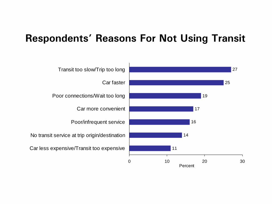
Respondents’ Reasons For Not Using Transit
11
14
16
17
19
25
27
0 10 20 30
Car less expensive/Transit too expensive
No transit service at trip origin/destination
Poor/infrequent service
Car more convenient
Poor connections/Wait too long
Car faster
Transit too slow/Trip too long
Percent

Changes Required to Increase Transit Use
59
9
55
5
14
16
21
44
10
10
8
13
10
15
11
0 10 20 30 40 50 60
Reduce costs/fares
Unsure
Other (incl. Parking,Security)
Nothing
Service related
Percent
Car OnlyCar & TransitTransit Only

What Do People Want From Transit?
fast, reliable transit service
competitive with car

Ridership Growth Strategy
Transit Rights-of-Way assessed, prioritized:
road at capacity by 2011?
forecast of future ridership based on Official Plan
feasibility of accommodating ROW
return on investment (new riders/$)

Summary Evaluation of Surface Rapid Transit Projects
Capital costs Annual new ridership
PriorityGroup
Currentannual
ridership
AtcapacityIn 2011
Projecttotal
Annual
Subsidyper new
rider
Pop.and
diverted
Attracteddue tospeed
Total
million $ million $ million $ million million million
Category 1Projects with current status
Downsview Stn toYork University/Steeles Ave
1 10.8 Yes $50.0 $3.3 $2.27 1.0 0.5 1.5
Yonge St – Finch Stn to Steeles 1 10.0 Yes $10.0 $0.7 $0.30 1.7 0.5 2.2
Sheppard Av East – Don Mills Stn toScarborough Centre Stn
2 7.5 Yes $113.8 $7.4 $4.76 1.2 0.4 1.6
Dundas St West – Kipling Stn toEtobicoke Creek
1 5.6 Yes $25.9 $1.7 $1.13 1.2 0.3 1.5
St. Clair Av streetcar – Yonge St toRunnymede
1 10.9 No $25.0 $1.6 $0.75 1.5 0.7 2.2

Summary Evaluation of Surface Rapid Transit Projects
Capital costs Annual new ridership
PriorityGroup
Currentannual
ridership
AtcapacityIn 2011
Projecttotal
Annual
Subsidyper new
rider
Pop.and
diverted
Attracteddue tospeed
Total
million $ million $ million $ million million million
Category 2Other corridors in Official Plan
Don Mills Rd/Overlea Blvd – Millwood AveTo Sheppard Av
2 4.9 No $96.0 $6.2 $5.32 0.8 0.4 1.2
Don Mills Rd – Sheppard Av to Steeles Av2 8.1 No $53.8 $3.5 $6.10 0.4 0.2 0.6
Eglinton Av West – Renforth Dr toWeston Rd
2 4.4 No $154.6 $10.0 $9.61 0.8 0.2 1.0
Eglinton Av East – Leslie St to KennedyStn
1 6.9 No $42.9 $2.8 $2.66 0.7 0.3 1.0
Eglinton Av East – Kennedy Stn toGuildwood GO Stn
1 13.8 No $42.9 $2.8 $1.33 1.4 0.7 2.1
Markham Rd – Ellesmere Rd to Steeles Av 3 2.5 No - - - - - -

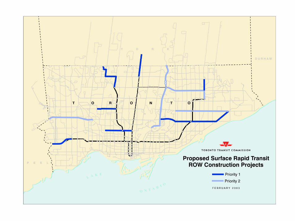


Transit Improvements in Toronto
R-O-W proposals require EA’s:
significant staff resources
1 - 2 years to complete EA
implementation of R-O-W’s:
$30 million - $90 million length, civil works, buses
2 - 3 years to construct

Staging - Start Date
2004
St. Clair (Yonge to Keele)
York U BRT (Downsview to Steeles)
Yonge Street (Finch to Steeles)

Staging - Start Date
2005
St. Clair: Keele Jane (Council directive)
Scarborough RT Corridor (preliminary EA work)
Don Mills (Steeles Danforth)
Waterfront “Transit First”: - West Don- East Bayfront
Transit Opportunities in Hydro Corridors

Staging - Start Date
2006
King Street (operational study/EA)
Sheppard East (Don Mills Scarborough City Centre)
Bremner Boulevard

Staging - Start Date
2007
Eglinton East (Kingston Road Leslie/Kennedy)
Kingston Road (Victoria Park Eglinton)

Staging - Start Date
2008
Eglinton West (Eglinton West Stn Renforth/Airport)
2009
Dundas West (Kipling Etobicoke Creek)— subject to regional terminal
Lawrence West (Spadina Subway Jane Street)

Top Related