


Languages
Pages
Legal

Amendment C325
Expert Evidence Statement CG40452
Prepared for St Leonards Property Holdings Pty Ltd
7 December 2015
Amendment C325
Expert Evidence Statement CG40452

Amendment C325 Expert Evidence Statement
7 December 2015 ) Cardno ii
Document Information
Prepared for St Leonards Property Holdings Pty Ltd
Project Name Expert Evidence Statement
File Reference CG140452Panel001F01.docx
Job Reference CG40452
Date 7 December 2015
Contact Information
Cardno Victoria Pty Ltd
Trading as Cardno
ABN 47 106 610 913
Level 4
501 Swanston Street
Melbourne
Victoria 3000 Australia
Telephone: (03) 8415 7777
Facsimile: (03) 8415 7788
International: +61 3 8415 7777
www.cardno.com
Document Control
Version Date Author Author Initials
Reviewer Reviewer Initials
F01 7/12/15 Tim McKinley
© Cardno. Copyright in the whole and every part of this document belongs to Cardno and may not be used, sold, transferred, copied or reproduced in whole or in part in any manner or form or in or on any media to any person other than by agreement with Cardno.
This document is produced by Cardno solely for the benefit and use by the client in accordance with the terms of the engagement. Cardno does not and shall not assume any responsibility or liability whatsoever to any third party arising out of any use or reliance by any third party on the content of this document.
Amendment C325 Expert Evidence Statement
7 December 2015 ) Cardno iii
Table of Contents
1 Planning Panels Victoria Guidelines 1
2 Introduction 3
3 Background 4
3.1 The Proposed Amendment 4
3.2 Delegate’s Report 4
4 Issues 5
5 Background and Existing Conditions 6
5.1 Location and Land Use 6
5.2 Existing Vehicular Access 6
5.3 Road Network 7
5.3.1 Ibbotson Street 7
5.3.2 Leviens Road 8
5.3.3 Bluff Road 9
5.3.4 Murradoc Road 11
5.3.5 Pearl Bay Passage 13
5.3.6 Gilbert Street 14
5.3.7 Seachange Way 14
5.4 Traffic Volumes – Local Streets 15
5.5 Sustainable Transport 16
5.5.1 Public Transport 16
5.6 St Leonards Structure Plan 17
6 Potential Development 18
6.1 General 18
6.2 Vehicle Access and Road Network 19
6.3 Pedestrians and Cyclists 20
6.4 Public Transport Access 20
7 Traffic Implications 21
7.1 Arterial Road Connections 21
7.2 Traffic Generation 21
7.3 Traffic Distribution 22
7.4 Traffic Impact on Local Streets 23
8 Road Network Considerations 24
8.1 External 24
8.2 Leviens Road Frontage and Access 24
8.3 Ibbotson Street 24
8.4 Bluff Road Frontage and Access 24
8.5 Bicycle and Pedestrian Connectivity 25
8.6 Internal 25
9 Response to Issues 26
9.1 Traffic Increases in Local Streets and “Hooning” 26
9.2 42 Pearl Bay Passage Access and Intersection 26
9.3 McBeth Street Footpath 27
9.4 Bluff Road Secondary Access Road 27
9.5 DEDJTR Submissions 27
9.6 Review of Schedule 39 to the Design and Development Overlay 29

Amendment C325 Expert Evidence Statement
7 December 2015 ) Cardno iv
9.7 Review of Outline Development Plan 29
10 Conclusions 30
Appendices
Appendix A Murradoc Road / Leviens Road intersection
Appendix B Proposed cross Sections
Tables
Table 5-1 Local Street Two-Way Traffic Volumes – October / November 2015 15
Table 6-1 Internal Road Network Street Types 19
Table 7-1 Access Point Distribution 23
Table 7-2 Local Street – Traffic Volume Increases 23
Figures
Figure 5-1 Site Location 6
Figure 5-2 Ibbotson Street, looking north from the subject site 7
Figure 5-3 Ibbotson Street, looking south from the subject site 7
Figure 5-4 Leviens Road, looking west from the subject site 8
Figure 5-5 Leviens Road, looking east towards the subject site 8
Figure 5-6 Leviens Road, looking west at the subject site boundary 9
Figure 5-7 Bluff Road, looking east from the subject site 9
Figure 5-8 Bluff Road, looking west towards Ibbotson Street 10
Figure 5-9 Bluff Road, looking east, east of Edwards Point Road 10
Figure 5-10 Murradoc Road, looking west from Ibbotson Street 11
Figure 5-11 Aerial - Murradoc Road / Ibbotson Street Intersection 12
Figure 5-12 Aerial - Murradoc Road / Leviens Road Intersection 12
Figure 5-13 Aerial - Murradoc Road / Bluff Road Intersection 13
Figure 5-14 Looking north, at 42 Pearl Bay Passage 13
Figure 5-15 Tube Count Locations 15
Figure 5-16 Existing St Leonards Bus Route Locations 16
Figure 5-17 St Leonards Structure Plan Areas 17
Figure 6-1 Exhibited Outline Development Plan 18
Figure 7-1 Study Area 21

Amendment C325 Expert Evidence Statement
7 December 2015 ) Cardno 1
1 Planning Panels Victoria Guidelines
The following report has been prepared In accordance with the Planning Panels Victoria Guide to Expert
Evidence. My qualifications, expertise and instructions to undertake this work are summarised below:-
Name:
Timothy Peter McKinley
Address:
Cardno
Level 4, 501 Swanston Street
Melbourne Vic 3000
Professional Qualifications:
> Bachelor of Engineering (Civil) Hons, 2003, University of Melbourne
> Bachelor of Commerce, 2003, University of Melbourne
> VicRoads Accredited Senior Road Safety Auditor
Professional Experience: > Cardno 2011 - present
> Cardno Grogan Richards 2007 – 2011
> VicRoads 2003 - 2007
Areas of Expertise:
> Car parking, traffic and transportation.
> Traffic advice and assessment of land uses and development proposals to planning authorities,
government agencies, corporations and developers (including residential, retail, commercial, industrial,
institutional and mixed use projects).
Expertise to Prepare this Report:
My training and experience including involvement with all forms of development over a number of years
qualifies me to comment on the traffic implications of the proposal.
Instructions which defined the scope of this report:
I have been requested by Norton Rose Fulbright, on behalf of St Leonards Property Holdings Pty Ltd, on 2nd
November 2015, to provide my expert opinion, in regards to Amendment C325 on the site addressed as:
▪ 2-20 Leviens Road, St Leonards ▪ 22-40 Leviens Road, St Leonards ▪ 152-200 Bluff Road, St Leonards ▪ 481-505 Ibbotson Street, St Leonards ▪ 511-529 Ibbotson Street, St Leonards ▪ 531-539 Ibbotson Street, St Leonards ▪ 541-569 Ibbotson Street, St Leonards ▪ 42 Pearl Bay Passage, St Leonards
I have been requested to provide my opinion on the following issues:
1. Amendment C325 Explanatory Report;
2. Draft Schedule 39 to the Design and Development Overlay;
Amendment C325 Expert Evidence Statement
7 December 2015 ) Cardno 2
3. Submissions received during the public exhibition.
Facts, Matters and Assumptions Relied Upon:
> Site visit, Thursday 3rd
December 2015;
> Greater Geelong Council Delegates Report, regarding Amendment C325;
> Previous Cardno Traffic and Transport Assessment, dated 19th November 2014;
> Planning Scheme Amendment;
> Submissions by various parties;
> Greater Geelong Planning Scheme;
> St Leonards Structure Plan;
> Austroads Guides to Road Design;
> Infrastructure Design Manual
Identity of Persons Undertaking the Work:
Tim McKinley of Cardno, assisted by Jeremy Peters also of Cardno.
I have made all the inquiries that I believe are desirable and appropriate, and no matters of significance,
which I regard as relevant, have to my knowledge been withheld from the Panel.
Tim McKinley
Associate
for Cardno

Amendment C325 Expert Evidence Statement
7 December 2015 ) Cardno 3
2 Introduction
It is proposed to rezone approximately 73.5 hectares of land within the St Leonards Growth Area 2 from
Farming Zone to General Residential Zone and apply a Design and Development Overlay to the land being
rezoned, as well as 42 Pearl Bay Passage.
This report has been prepared in accordance with the Planning Panels Victoria Guidelines. In the course of
preparing this assessment, I have inspected the subject site and surrounding road network, researched
relevant case study data, analysed relevant traffic volume data, reviewed the proposed documents and plans
outlined in Section 1.
My opinions with respect to the proposed rezoning are set out in the following report.

Amendment C325 Expert Evidence Statement
7 December 2015 ) Cardno 4
3 Background
3.1 The Proposed Amendment
The proposed Amendment C325 to the Greater Geelong Planning Scheme applies to 73.5 hectares of land
located generally surrounded by Leviens Road, Ibbotson Street, Bluff Road and the lots to the west of Pearl
Bay Passage.
In November 2014, the landholders lodged a request to amend the planning scheme and rezone the land
from Farming Zone 1 to General Residential Zone 1, and apply the Design and Development Plan Overlay
(Schedule 39). I prepared a Traffic and Transport Assessment, dated 19th November 2014 that was
submitted in association with the rezoning and adopt this report as part of this evidence statement.
Since the preparation of the November 2014 report, the following traffic and transport related items have
occurred:
▪ Council encouraged that a property along Pearl Bay Passage be purchased to provide a connection between GA2 and the residential area to the east;
▪ An Outline Development Plan has been established, nominating potential site access points as well as retarding basin areas which may restrict vehicular access;
▪ Follow up meetings between Council, VicRoads, DEDJTR and the applicant have been held with respect to the provision of external road infrastructure to mitigate against the traffic impacts of the rezoning and subsequent subdivision.
Noting the above, I adopt this document as my Statement of Expert Evidence for the purposes of the Independent Panel convened to consider Amendment C325.
3.2 Delegate’s Report
The Amendment and was advertised between 17 September 2015 and 19 October 2015 and a total of 27
submissions were received. Of these submissions, 18 were objections.
A Council Delegate’s Report was prepared for the Amendment. Key Issues were identified in the report with
the following issues relevant to this assessment:
Lack of Infrastructure in St Leonards to support the population increase;
The proposed road link at 42 Pearl Bay Passage is not supported;
Transport and movement concerns from the Department of Transport.
In Summary the Delegate’s Report stated that:
“Council officers have considered the submissions and do not recommend any major changes from what
was exhibited. Some changes to the DDO Schedule are proposed in response to submissions from the
proponent and agencies, and further review from Council officers.”

Amendment C325 Expert Evidence Statement
7 December 2015 ) Cardno 5
4 Issues
The issues dealt with in this report are the traffic and transport implications of the proposed rezoning of
Growth Area 2, inclusive of the following issues raised by local residents, landowners and authorities:
General traffic increases;
Eastern connection to Pearl Bay Passage;
McBeth Street Footpath;
Bluff Road secondary access location;
Potential development west of Ibbotson Road;
East-west internal roads; and
Bicycle treatment widths.
It is of note that the proposed arterial road intersection treatments at Murradoc Road / Leviens Road and
Murradoc Road / Bluff Road have not been raised in submissions and therefore no additional analysis of
these intersections has been undertaken within this report.
Council also noted the need for further discussions with the applicant regarding cross sections of roads
within the site.

Amendment C325 Expert Evidence Statement
7 December 2015 ) Cardno 6
5 Background and Existing Conditions
5.1 Location and Land Use
The subject site is located south-east of Murradoc Road, St Leonards, within the block bounded by Leviens
Road to the north (530m), Ibbotson Street to the west (1150m), Bluff Road to the south (610m) and existing
residential lots to the east as shown in Figure 5-1. This forms “Growth Area 2” as defined in the St Leonards
Structure Plan and has a total land area of Growth Area 2 is 73.55 hectares. Further to this, a parcel of land
at 42 Pearl Bay Passage has been included as part of this parcel for future road connectivity to the east.
The site is currently flat and undeveloped, and was previously utilised for farming purposes. Land
surrounding the site is generally residential to the north, south and east, with farming land to the west. The
Charles McCarthy Memorial Oval abuts the site at its northern boundary.
Figure 5-1 Site Location
5.2 Existing Vehicular Access
Various private vehicular access points to the subject site are currently provided as follows:
▪ Three from Leviens Road
▪ Two from Bluff Road
▪ Six from Ibbotson Street
Subject Site Growth Area 1

Amendment C325 Expert Evidence Statement
7 December 2015 ) Cardno 7
5.3 Road Network
5.3.1 Ibbotson Street
Ibbotson Street is a local road running north-south between Batman Road in the north and Bluff Road in the
south, abutting the western boundary of the site.
Within the vicinity of the site, Ibbotson Street is an unsealed gravel road, as shown in Figure 5-2 and Figure
5-3. Existing properties along the eastern side of Ibbotson Street take access via an unsealed access road,
as shown in Figure 5-3. Ibbotson Street does not display speed limit signs south of Murradoc Road and
therefore the default speed limit applies. Observations on-site indicate that the vegetation on both sides of
Ibbotson Street, in the vicinity of the subject site, are identified within a ‘Biodiversity Conservation Area’ and
are protected from any activity or disturbance.
Figure 5-2 Ibbotson Street, looking north from the subject site
Figure 5-3 Ibbotson Street, looking south from the subject site

Amendment C325 Expert Evidence Statement
7 December 2015 ) Cardno 8
5.3.2 Leviens Road
Leviens Road is a local road running east-west between Bluff Road in the east and Murradoc Road in the
west.
Within the vicinity of the site, Leviens Road has a sealed carriageway with unsealed shoulders, as shown in
Figure 5-4 and Figure 5-5, and has a posted speed limit of 60 km/h (seasonally adjusted to 50km/h). Existing
lots on the northern side of Leviens Road take access via concrete driveways, as shown in Figure 5-5.
Figure 5-4 Leviens Road, looking west from the subject site
Figure 5-5 Leviens Road, looking east towards the subject site
Amendment C325 Expert Evidence Statement
7 December 2015 ) Cardno 9
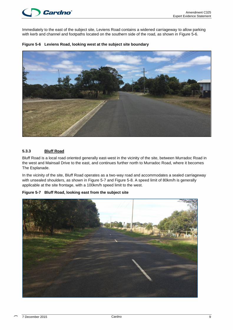
Immediately to the east of the subject site, Leviens Road contains a widened carriageway to allow parking with kerb and channel and footpaths located on the southern side of the road, as shown in Figure 5-6.
Figure 5-6 Leviens Road, looking west at the subject site boundary
5.3.3 Bluff Road
Bluff Road is a local road oriented generally east-west in the vicinity of the site, between Murradoc Road in
the west and Mainsail Drive to the east, and continues further north to Murradoc Road, where it becomes
The Esplanade.
In the vicinity of the site, Bluff Road operates as a two-way road and accommodates a sealed carriageway
with unsealed shoulders, as shown in Figure 5-7 and Figure 5-8. A speed limit of 80km/h is generally
applicable at the site frontage, with a 100km/h speed limit to the west.
Figure 5-7 Bluff Road, looking east from the subject site

Amendment C325 Expert Evidence Statement
7 December 2015 ) Cardno 10
Figure 5-8 Bluff Road, looking west towards Ibbotson Street
The section of Bluff Road, east of Edwards Point Road, contains a widened westbound carriageway as well as kerb and channel on the southern side of the carriageway, as shown in Figure 5-9. A speed limit of 50km/h applies in this residential section.
Figure 5-9 Bluff Road, looking east, east of Edwards Point Road

Amendment C325 Expert Evidence Statement
7 December 2015 ) Cardno 11
5.3.4 Murradoc Road
Murradoc Road is a Declared Main Road and extends between Drysdale in the west and St Leonards in the
east.
Within the vicinity of the site, Murradoc Road consists of a single carriageway with one traffic lane in each
direction plus sealed shoulders of approximately 1.5 metres shared within cyclists. At the intersection of Bluff
Road / Murradoc Road currently has a posted speed limit of 100 km/h. Further north-east towards Leviens
Road, the speed limit is 70km/h, while closer to the town centre, a 60km/h speed limit applies.
A typical cross section of Murradoc Road is shown in Figure 5-10, an aerial of the intersection of Murradoc
Road / Ibbotson Street is shown in Figure 5-11, an aerial of the intersection of Murradoc Road / Leviens
Road in Figure 5-12 and Murradoc Road / Bluff Road in Figure 5-13.
Figure 5-10 Murradoc Road, looking west from Ibbotson Street

Amendment C325 Expert Evidence Statement
7 December 2015 ) Cardno 12
Figure 5-11 Aerial - Murradoc Road / Ibbotson Street Intersection
Figure 5-12 Aerial - Murradoc Road / Leviens Road Intersection

Amendment C325 Expert Evidence Statement
7 December 2015 ) Cardno 13
Figure 5-13 Aerial - Murradoc Road / Bluff Road Intersection
5.3.5 Pearl Bay Passage
Pearl Bay Passage is a local access street that generally runs north-south, other than at two short east-west
sections at its connection to Seachange Way and Mainsail Drive.
In the vicinity of Gilbert Street and Seachange Way, Pearl Bay Passage consists of a single carriageway of
7.0m width, with parking allowed on both sides of the road. A footpath is provided within the western verge
only.
A default speed limit of 50km/h is present, while no parking restrictions are present.
Figure 5-14 Looking north, at 42 Pearl Bay Passage

Amendment C325 Expert Evidence Statement
7 December 2015 ) Cardno 14
5.3.6 Gilbert Street
Gilbert Street is a local access street that runs east-west between Pearl Bay Passage and Bluff Road.
Gilbert Street consists of a single carriageway of 7.0m width, with parking allowed on both sides of the road.
A footpath is provided only at the western half of the road.
A default speed limit of 50km/h is present, while no parking restrictions are present.
A roundabout is formed at the intersection of Gilbert Street and Seachange Way, with other traffic calming
also present.
5.3.7 Seachange Way
Seachange Way is a local access street that runs from Sandbar Street in the south to Leviens Street in the
north. It continues as Cole Street, north of Leviens Street.
Seachange Way consists of a single carriageway of 7.0m width, with parking allowed on both sides of the
road. A footpath is provided on both sides of the road.
A default speed limit of 50km/h is present, while no parking restrictions are present.
A roundabout is formed at the cross intersection of Seachange Way with both Leviens Street and Gilbert
Street, with simple t-intersections formed at other intersecting streets.
Amendment C325 Expert Evidence Statement
7 December 2015 ) Cardno 15
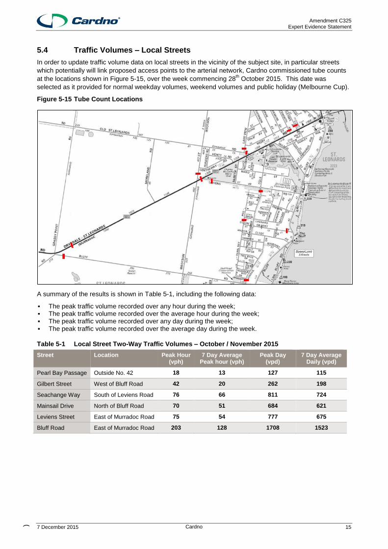
5.4 Traffic Volumes – Local Streets
In order to update traffic volume data on local streets in the vicinity of the subject site, in particular streets
which potentially will link proposed access points to the arterial network, Cardno commissioned tube counts
at the locations shown in Figure 5-15, over the week commencing 28th October 2015. This date was
selected as it provided for normal weekday volumes, weekend volumes and public holiday (Melbourne Cup).
Figure 5-15 Tube Count Locations
A summary of the results is shown in Table 5-1, including the following data:
▪ The peak traffic volume recorded over any hour during the week; ▪ The peak traffic volume recorded over the average hour during the week; ▪ The peak traffic volume recorded over any day during the week; ▪ The peak traffic volume recorded over the average day during the week.
Table 5-1 Local Street Two-Way Traffic Volumes – October / November 2015
Street Location Peak Hour (vph)
7 Day Average Peak hour (vph)
Peak Day (vpd)
7 Day Average Daily (vpd)
Pearl Bay Passage Outside No. 42 18 13 127 115
Gilbert Street West of Bluff Road 42 20 262 198
Seachange Way South of Leviens Road 76 66 811 724
Mainsail Drive North of Bluff Road 70 51 684 621
Leviens Street East of Murradoc Road 75 54 777 675
Bluff Road East of Murradoc Road 203 128 1708 1523

Amendment C325 Expert Evidence Statement
7 December 2015 ) Cardno 16
5.5 Sustainable Transport
5.5.1 Public Transport
The site has public transport accessibility, with a bus service located along Leviens Road. Public transport
services in St Leonards is limited to Bellarine Transit services bus routes, which operate along Murradoc
Road and Geelong-Portarlington Road, with parts of the service extending into residential streets.
Bus Route 60 operates from the Geelong Railway Station to St Leonards, via Portarlington. Thirteen (14)
services operate between 5:00am and 9:00pm weekdays, with services approximately every hour between
7:00am and 2:00pm. Furthermore, seven (7) services currently operate on Saturday’s and five (5) services
on Sunday’s and Public Holidays.
Figure 5-16 Existing St Leonards Bus Route Locations
Subject Site
Bus Route

Amendment C325 Expert Evidence Statement
7 December 2015 ) Cardno 17
5.6 St Leonards Structure Plan
The 2014 St Leonards Structure Plan identified the subject site as Growth Area 2. Furthermore, an additional
growth area, north of Murradoc Road, known as Growth Area 1, was identified within the St Leonards
Structure Plan. The Structure Plan states that the two sites are estimated to provide between 25 and 33
years supply of land for the St Leonards Township.
The St Leonards Structure Plan was adopted by the City of Greater Geelong in February 2014. Within the
Structure Plan, two growth areas were identified as long term residential growth areas capable of
accommodating in the order of 1400 lots. Furthermore, the Structure Plan indicated that there are no
planned major upgrades/improvements to the road network within the township of St Leonards.
The location of the subject site within the St Leonards Structure Plan area is shown in Figure 5-17. It is
noted that the land to the west is protected for “resource and scenic value”.
Figure 5-17 St Leonards Structure Plan Areas
Subject Site
Amendment C325 Expert Evidence Statement
7 December 2015 ) Cardno 18
6 Potential Development
6.1 General
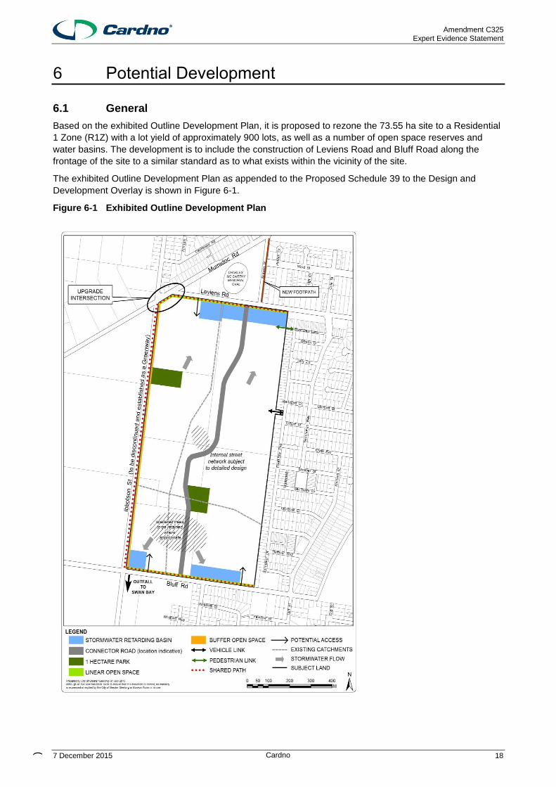
Based on the exhibited Outline Development Plan, it is proposed to rezone the 73.55 ha site to a Residential
1 Zone (R1Z) with a lot yield of approximately 900 lots, as well as a number of open space reserves and
water basins. The development is to include the construction of Leviens Road and Bluff Road along the
frontage of the site to a similar standard as to what exists within the vicinity of the site.
The exhibited Outline Development Plan as appended to the Proposed Schedule 39 to the Design and
Development Overlay is shown in Figure 6-1.
Figure 6-1 Exhibited Outline Development Plan

Amendment C325 Expert Evidence Statement
7 December 2015 ) Cardno 19
6.2 Vehicle Access and Road Network
Access to the site from the surrounding road network is shown to be provided via a number of access points
along Leviens Road to the north and Bluff Road to the south. At each of these road frontages, a single major
connector road access is to be installed, supplemented by smaller access streets. A further access street
link is shown to be provided to Pearl Bay Passage to the east of the site to integrate the site into the
Seachange Estate area. Access to Ibbotson Street has been minimised due to significant vegetation and the
rural interface along the western boundary of the site. A “greenway” is proposed along this boundary, with
no significant vehicle access, nor vehicular connection to Murradoc Road from Ibbotson Street.
The development is to include road pavement sealing and installation of kerb and channel adjacent the sites
boundary to Leviens Road and Bluff Road, to a similar standard to what exists surrounding the subject site.
It is understood that most properties will be accessed from the internal road network proposed. All access
points will form T-intersections with Leviens Road, Bluff Road (or roundabouts if desired) with “Give Way”
signage and line marking installed.
The road network for the subdivision will comprise of Access Streets and a Connector Road. It is
recommended that the internal access street network for the residential subdivision be designed in
accordance with various applicable design criteria, including Clause 56 of the Greater Geelong Planning
Scheme, the Infrastructure Design Manual adopted by Greater Geelong Council or Growth Area Structure
Plans located within Greater Geelong. The indicative road hierarchy proposed road cross sections are
shown in Table 6-1.
Table 6-1 Internal Road Network Street Types
Type Road Reserve
Indicative Capacity Carriageway Cyclists / Pedestrians
Level 1 Access Street
13.5m 1,000-2,000 vpd 5.5m 2 x 1.5m wide footpath
Level 2 Access Street (Adjacent Open Space)
13.5m 2,000-3,000 vpd 7.3m 1 x 1.5m wide footpath within road reserve
1 x 1.5m wide footpath within open space
Level 2 Access Street
16.0m 2,000-3,000 vpd 7.3m 2 x 1.5m wide footpath
Level 1 Connector Street
22.0m-24.0m
3,000 vpd-7,000vpd 3.5m lane in each direction plus parking lane
1 x 2.5m wide shared path
1 x 1.5m footpath
Amendment C325 Expert Evidence Statement
7 December 2015 ) Cardno 20
6.3 Pedestrians and Cyclists
The Outline Development Plan shows a shared path network along the northern (Leviens Road), southern (Bluff Road) and western (Ibbotson Street) frontages of the site. Further to this, a bicycle/pedestrian connection to the existing Diver Dan Lane is proposed in the north eastern section of the GA2 land. The internal pedestrian and cycle network will comprise of a shared path and open space path network, as well as standard footpaths within the street network.
No pedestrian paths are currently provided within the existing Leviens Road and Bluff Road reserves. As
such, external pedestrian access to the subject land will be limited until such time as Leviens Road and Bluff
Road are fully constructed.
6.4 Public Transport Access
The north-south connector road is to provide for public transport movements within the site, relying on new
or rerouted bus services from the surrounding road network. This will allow for all lots to be located within
reasonable proximity to a potential bus route.

Amendment C325 Expert Evidence Statement
7 December 2015 ) Cardno 21
7 Traffic Implications
7.1 Arterial Road Connections
It is proposed to utilise the existing Murradoc Road / Bluff Road intersection, which provides a channelised
right turn lane to minimise the impact of turning traffic on through vehicles. A channelised right turn
treatment is proposed to be constructed at the intersection of Murradoc Road / Leviens Road to mitigate
against the impact of right turning traffic.
These treatments have been analysed in the previous Cardno report and agreed by VicRoads and Council
after subsequent meetings and therefore no further analysis of these intersections is shown.
The proposed intersection at Murradoc Road / Leviens Road is shown within concept plans attached as
Appendix A, specifically highlighting works associated with GA2. This plan also outlines works at the
Murradoc Road / Ibbotson Street intersection, noting that these works are associated with GA1 only and this
has been specified within the proposed GA1 permit conditions.
7.2 Traffic Generation
A traffic generation study was undertaken over the week of 28th October-3
rd November 2015, with traffic
volumes measured within an enclosed area of St Leonards with the only access via Lakeview Crescent,
Coatesworth Avenue and Wattletree Avenue as shown in Figure 7-1.
Figure 7-1 Study Area

Amendment C325 Expert Evidence Statement
7 December 2015 ) Cardno 22
The daily average for traffic generation in this section St Leonards was 1632 vehicle movements per day,
with the peak activity occurring on the Saturday with 2005 vehicle movements per day. The total number of
dwellings in this area at this time was 386 dwellings (excluding unoccupied lots), which equates to a traffic
generation rate of 4.2 vehicle movements per day and 5.2 vehicle movements per day respectively.
Based on the foregoing, it is projected that the rezoned GA2 area will produce 3,780-4,680 movements per
day, inclusive of up to 470 movements in the morning and evening peak hours.
The previous analysis prepared by Cardno was highly conservative for the proposed residential rezoning,
adopting 10 vehicle movements per lot per day. This is unlikely to ever be achieved at any time other than
the absolute peak over the Christmas / New Year period.
7.3 Traffic Distribution
The distribution of traffic to and from the site will be a function of a number of factors as follows:
The location of access points to the surrounding road network;
The purpose of the trip;
The location of work destinations;
The location of retail and other facilities.
It is generally accepted that for residential developments, approximately 80% of trips are outbound and 20%
inbound in the AM peak. Conversely in the PM peak, 60% are inbound and 40% are outbound.
In consideration of the existing road network and in particular the location of local schools, the St Leonards
and Geelong Townships and access to arterial roads, it is expected that traffic generated by the site will
mainly utilise:
> Murradoc Road (or Bluff Road) to access the St Leonards Township, Geelong and all other areas of the
Bellarine Peninsula; and
> Ibbotson Street (or Bluff Road) and Murradoc Road to access parts of the Bellarine Peninsula.
The distribution of vehicle movements is based on the location of surrounding employment centres, local and
major shopping destinations, recreational destinations and schools and other education centres. Only a
small percentage of the work related trips will be to destinations within the St Leonards Township, with the
majority to Geelong and the remainder to the Bellarine Peninsula / Portarlington / Point Lonsdale. Likely
traffic destinations within St Leonards, such as the schools and shops, typically front Murradoc Road. The
majority of local and supermarket shopping trips will be to the IGA Supermarket which fronts Murradoc Road.
Other shopping trips for household goods, clothing etc. will primarily be to Geelong. Recreational trips will
likely be towards Geelong. The majority of educational trips will be generated to and from St Leonards or
Geelong, with some trips also likely to Portarlington / Drysdale.
It has been assumed that 35% of traffic will travel to/from the site via Leviens Road and the remaining 65%
to travel to/from the site via Bluff Road.
From the above, the following distribution of residential traffic to the surrounding area has been adopted.
> Bellarine Peninsula / Geelong (inc. Drysdale) 75%
> St Leonards 25%
Having regard to the location of proposed access points, journey to work data and the location of
surrounding facilities, the distribution of traffic to and from the development at each access point on a daily
basis has been modelled as shown in the following table. It is noted that the internal local road network will
be resolved at the detailed design stage, however the majority of traffic into St Leonards would be
encouraged to use the more direct central connector street via Leviens Street rather than a less direct Pearl
Bay Passage link. Gilbert Street is likely to provide a more convenient access to the foreshore for a small
pocket of lots in the north-eastern section of the subject site.
Amendment C325 Expert Evidence Statement
7 December 2015 ) Cardno 23
Table 7-1 Access Point Distribution
Access Point Percentage Traffic Distribution Daily Generated Vehicle Movements
Pearl Bay Passage 2%* 94vpd
Leviens Road 23%* 1076vpd
Bluff Road 75% 3510vpd
Total 100% 4680 vehicles per day
7.4 Traffic Impact on Local Streets
Future traffic volumes on local streets in the vicinity of the site have been modelled having regard to the
distribution analysis undertaken above, and exiting traffic volume data detailed in Table 5-1.
Projected volume increases on each road link are shown in Table 7-2.
Table 7-2 Local Street – Traffic Volume Increases
Street Section Category Existing Volume Projected Additional Volume
Total
Pearl Bay Passage
Outside No.42 Access Street 115 vpd 94vpd 209vpd
Gilbert Street West of Bluff Access Street 198 vpd 94vpd 292vpd
Leviens Road East of Murradoc
Connector Street 675 vpd 1076vpd 1751vpd
Bluff Road East of Murradoc
Connector Street 1573 vpd 3510vpd 5083vpd
Each of the existing streets has been constructed as a conventional 7.0 m road pavement width, designed to
accommodate intermittent kerbside parking along each kerb and two way traffic movements. Where two
cars are parked opposite each other, a single two way traffic lane remains.
Clause 56.06-8 of the Greater Geelong Planning Scheme, which sets out the design of roads and
neighbourhood streets for residential subdivisions, defines an “Access Street – Level 2” as “a street
providing local residential access where traffic is subservient, speed and volume are low and pedestrian and
bicycle movements are facilitated.”
These streets are recommended to provide characteristics shown in Table 6-1.
I have reviewed each of the above streets as to their existing design standard and function and in my view;
each is constructed (or proposed to be constructed) and operates in accordance with conventional access
and connector streets. Significant increases in traffic volumes over the Christmas holiday period would also
be able to be accommodated.
Projected traffic volume increases in each street are moderate in absolute terms and, while some increases
are significant in relative terms (when viewed against relatively low existing volumes) total volumes remain
comfortably within acceptable levels for an access or connector street and will not impact significantly on the
existing function, operation or amenity of the existing streets.
In my view, the connections as proposed are desirable to integrate the development with existing
neighbourhoods and that the traffic implications of the connections on existing streets are moderate and
acceptable. Additional access for emergency vehicles and alternative access for residents is desirable. It is
of note that internal streets will be subject to further detailed design.

Amendment C325 Expert Evidence Statement
7 December 2015 ) Cardno 24
8 Road Network Considerations
Having regard to the expected traffic volumes and road functions, I recommend the following road works be
adopted with respect to external, abutting and internal roads
8.1 External
The only external works considered necessary is the provision of a right turn treatment at Murradoc Road /
Leviens Road. For a 70km/h speed environment, the length of the turn lane would require a minimum length
of 55m for deceleration. The concept plan for this intersection is shown in Appendix A.
8.2 Leviens Road Frontage and Access
Based on the anticipated traffic volumes illustrated in Table 7-2, it is recommended that at least two access
points be provided to Leviens Road. The primary access point should be designed to the standard of a Level
1 Connector Street with a carriageway width of 7.0 metres plus additional parking. The secondary access
points should be designed to the standard of a Level 2 Access Street with a carriageway width of 7.3 metres,
inclusive of parking.
It is recommended that the drainage, parking and footpath works would be undertaken by the developer for
the southern side of the road only, with the lane width being matched in with the existing widening that has
already occurred to the east.
No turning treatment is likely to be required at the intersection of Leviens Road and the access points. The
traffic volumes would be significantly less than the Leviens Street / Murradoc Road intersection analysed in
the previous report.
Anticipated cross sections for the frontage are shown in Appendix B.
8.3 Ibbotson Street
Ibbotson Street, in the vicinity of the subject site is identified as a Biodiversity Conservation Area. It is
therefore recommended that no road works or supplementary verge and drainage works occur along this
portion of Ibbotson Street to preserve the existing environment.
Further to this, any access to Ibbotson Street would provide traffic access to the southern leg of the Ibbotson
Street / Murradoc Road intersection. Given the traffic volumes generated by GA1 on the northern leg of this
intersection, any additional traffic volumes on the southern leg are likely to create potential safety and
operational issues at this intersection by creating a cross intersection. No vehicular access from the GA2
area to Ibbotson Street is recommended, as well as the “greenway” proposed.
8.4 Bluff Road Frontage and Access
Based on the anticipated traffic volumes shown in the previous traffic report, it is recommended that at least
two access points be provided to Bluff Road. The primary access point should be designed to the standard
of a Level 1 Connector Street with a carriageway width of 7.0 metres, plus parking. The secondary access
points should be designed to the standard of a Level 2 Access Street with a carriageway width of 7.3 metres.
I consider a secondary access point in the south-eastern portion of the site to be good design practice as it
creates a block size in accordance with 56.06-7 of the Greater Geelong Planning Scheme (maximum 240m),
and will reduce the reliance on the north-south connector to access the GA2 area from Bluff Road.
It is noted that the drainage, parking and footpath works would be undertaken by the developer for the
northern side of the road only, with the lane width being matched in with the existing widening that has
already occurred at the residential interface.
Similarly to Leviens Road, no turning treatment is required at the intersection of Bluff Road and the access
points.
Anticipated cross sections for the frontage are shown in Appendix B.

Amendment C325 Expert Evidence Statement
7 December 2015 ) Cardno 25
8.5 Bicycle and Pedestrian Connectivity
The 2014 St Leonards Structure Plan identifies that the majority of residential streets in St Leonards have no
formal pedestrian paths, wide grassy verges and a lack of kerb and channel. Notwithstanding this, it is
recommended that the site frontage to Leviens Road and Bluff Road provide footpaths at the site frontage to
match into any existing or future footpaths to the east of the subject site.
The 2014 St Leonards Structure Plan Cycling Strategy identifies Leviens Road as a key bicycle route, which
provides a connection to Murradoc Road, which connects Geelong and the Bellarine Peninsula. It is
recommended that the north-south Connector Road provide a shared path to connect the subject site to
Leviens Road and the surrounding bicycle network.
A proposed local pedestrian/bicycle connection at Diver Dan Lane is also considered beneficial to provide
direct local access to the beach, without requiring residents to “double back” via the Connector Street and
Leviens Road due to the potential presence of the retarding basin.
8.6 Internal
It is recommended that the internal road network is designed in accordance with Clause 56.06 of the City of
Greater Geelong Planning Scheme – Access and Mobility Management, with cross sections generally
designed as Level 2 Access Streets, other than the central north-south connection between Leviens Road
and Bluff Road, which will be designated as a Level 1 Connector Road.
The north-south connector should be designed to the standard of a Level 1 Connector Road and provide for
a future bus route and an off road share path. Treatments such as midblock slow points should be
incorporated into the road design where applicable to ensure that vehicle speeds are maintained at
appropriate levels on these roads.
Anticipated internal cross sections are shown in Appendix B.

Amendment C325 Expert Evidence Statement
7 December 2015 ) Cardno 26
9 Response to Issues
I have reviewed the relevant traffic and transport related submissions and respond as follows.
9.1 Traffic Increases in Local Streets and “Hooning”
Likely travel routes to the east of the site include Pearl Bay Passage, Gilbert St and Seachange Way. Each
of these roads contains a carriageway of a minimum 7.0m width. Gilbert St and Seachange Way contain
speed control devices/features including roundabouts, narrowings, raised sections or bends to limit speeds
through the local street network.
Traffic increases in local streets in the vicinity of the site are moderate and well within the environmental
capacity of each street as defined in Clause 56.06-8 of the Greater Geelong Planning Scheme.
Projected traffic volume increases on local streets in the vicinity of the site are moderate in absolute terms,
and the total volumes remain comfortably within acceptable levels for an access street. Increased volumes
will not impact significantly on the existing function, operation or amenity of the existing streets.
In my view, the connections as proposed are desirable to integrate the development with existing
neighbourhoods and that the traffic implications of the connections on existing streets are moderate and
acceptable.
9.2 42 Pearl Bay Passage Access and Intersection
Various submissions objected to the use of 42 Pearl Bay Passage as a vehicular connection to the subject
area, citing increased traffic, noise and intersection concerns.
In my view, it is desirable to provide vehicular access connections to integrate the Growth Area 2 land with
the Sea Change Estate land. This will provide for vehicular connectivity in both directions (i.e. allow Pearl
Bay Passage users to head west towards Geelong as well as local traffic from the GA2 area to head east
towards Gilbert Street and the beach). Permeability within a local road network is considered desirable, to
avoid the creation of “gated communities” or barriers for local traffic.
Council’s Delegates Report suggested that “If the link was not created, integration could only occur from
Leviens Road and Bluff Road. This would be a very poor outcome.” I agree with this assessment by
Council.
The carriageway width of Pearl Bay Passage lies within the range of 7-7.5m, which, under the Greater
Geelong Planning Scheme is classified as an Access Street – Level 2, allowing car parking on either side of
the road, and an environmental traffic capacity of 2000-3000vpd. The surveys undertaken by Cardno
suggest that the volumes of less than 130vpd currently exist at Pearl Bay Passage outside No.42, which is
significantly lower than the environmental capacity for this street. Gilbert Street and Seachange Way carried
a maximum of 262vpd and 811vpd. Even allowing for full development of unoccupied lots within the
Seachange area (18% increase) and seasonal variation in occupancy, traffic volumes will still fall well below
the indicative maximum of 3000vpd.
42 Pearl Bay Passage is one of few vacant lots of sufficient width to be able to accommodate a standard
access street, with a width of 20m allowing for the construction of a standard access street (7-7.5m
carriageway plus verge width and footpaths).
The location of a new access road at 42 Pearl Bay Passage will be directly opposite side fences and a
garage and therefore headlight glare is unlikely to be a significant problem at this location. A standard t-
intersection would be formed at this intersection, with good sightlines available in both directions. I do not
believe that the intersection will be unsafe.
The Delegates Report also stated that “Council does not envisage any safety issues”.
A similar intersection to the potential 42 Pearl Bay Passage intersection exists at Horne Avenue / Leviens
Road and Seaview Avenue / Leviens Road.

Amendment C325 Expert Evidence Statement
7 December 2015 ) Cardno 27
9.3 McBeth Street Footpath
Some submissions did not wish for a pedestrian footpath along McBeth Street to be included within the Amendment. St Leonards in general provides few pedestrian paths on road frontages, especially Murradoc Road, Leviens Road and Bluff Road. Therefore any connection would be discontinuous. With the proposed connector road joining Leviens Street approximately 150m to the west of McBeth Street, the desire line to Murradoc Road is likely to be directly north through Charles McCarthy Oval. The need for a pedestrian path at this location was not specified within the St Leonards Structure Plan as part of a holistic network. I do not believe there is significant justification for a pedestrian path to be provided along McBeth Street as part of the Amendment.
9.4 Bluff Road Secondary Access Road
A submission objected to vehicle noise, traffic and lights in the vicinity of the proposed access to Bluff Road at the south-eastern section of GA2. The Outline Development Plan is indicative only, however in my view a secondary access point near this location is desirable. A retarding basin will limit opportunities for site access midblock, so a secondary access to the east will allow for the catchment of vehicle movements to the south-east that are located well away from the proposed connector road. This low order, low volume street would create a similar intersection to the existing Horne Avenue / Leviens Road and Seaview Avenue / Leviens Road intersection.
9.5 DEDJTR Submissions
A coordinated submission from the Department of Economic Development, Jobs, Transport and Resources,
Vic Roads and Public Transport Victoria with respect to the Amendment dated 23rd
October 2015 provided
various comments.
The Department suggested:
The proposed central North-South connector road is generally supported, however a more direct and
continuous alignment with existing roads in the abutting residential areas to the north and south is preferred.
This would also assist with development of the future bus network.
Similarly a primary East-West street needs to be established, ideally in continuous alignment with either
Sandbar Street or Anchor/Clyde Street. Either would provide continuity between the new and existing
development areas as well as access to the bus service along Seachange Way and Sandbar Street.
Additionally, if Anchor/Clyde Street is selected, it would provide direct onward connectivity to the
bay/foreshore.
I disagree with the connector road being aligned in the north-south direction with existing streets. The
purpose of the connector street is to provide a central connection from the residential streets to the major
site access points along Leviens Road and Bluff Road. By offsetting this connector street to align with
McBeth Street to the north, the connector street would be skewed well towards the eastern end of the site
and not perform its function for the lots situated to the west of the site. A connector street is also designed to
carry buses, and therefore alignment with McBeth Street would also limit bus accessibility for lots situated to
the west of the site. Further to this, the carriageways of McBeth Street and Edwardes Point Road are not
designed to cater for bus traffic.
Cross intersections are not desirable from a traffic safety perspective, and should be eliminated from designs
where possible. In my view, a centrally located connector road with t-intersections at Bluff Road and Leviens
Road provide for adequate and access for both buses and local residents.
I agree with Council’s Delegates Report statement that “the north-south connector road should be located as
centrally as possible between Ibbotson Street and the eastern boundary and will act like a spine for the
estate”.
I disagree with the request for a primary east-west street to be provided. A direct connection to Clyde Ave or
Sandbar Street is not possible due to properties located along Pearl Bay Passage not being available. This
request is also contradictory to the statement provided by PTV in the same letter that categorically rules out
Pearl Bay Passage for use as a bus route. Travel routes from GA2 are likely to be biased towards Murradoc
Road via Bluff Road or Leviens Road to access the St Leonards town centre and Geelong and therefore a

Amendment C325 Expert Evidence Statement
7 December 2015 ) Cardno 28
primary traffic route to the east is unnecessary. Ibbotson Street is proposed to become a “greenway” without
vehicular access and therefore does not require any primary east-west street connection.
A minor Access Street is proposed to be provided at 42 Pearl Bay Passage to allow connection for residents
to the foreshore.
I agree with Council’s Delegates Report statement that “did not advocate for a primary east-west street,
advising that any connection to the subdivision must not encourage significant traffic movements”.
Public Transport Victoria stated:
It is noted that Pearl Bay Passage is not a through road and hence cannot be used for any bus operation.
The only option of servicing this area is through Ibbotson Street and Bluff Road. Therefore these two roads
need to be constructed to allow bus operation.
Ibbotson Street is to become a “greenway” so construction of this road for buses is not considered to be
appropriate. It is proposed that the north-south connector street will be designed to carry buses. Widening
of the carriageway abutting the GA2 area along Leviens Road and Bluff Road will also improve potential bus
operation at the site frontage.
VicRoads stated it has no objection to the Planning Scheme Amendment subject to the traffic impact
assessment report being revised to incorporate intersection upgrades including:
Murradoc Road / Ibbotson Street – sealing of the bell mouth on the southern side of Murradoc Road;
Murradoc Road / Leviens Road – a right turn lane shall be provided on Murradoc Road on the west
approach to the intersection.
Further to Section 8.1, I agree with a right turn lane being provided on the western approach to the Murradoc
Road / Leviens Road intersection. However I disagree with the provision of a sealed bell mouth at Ibbotson
Street south of Murradoc Road. The southern leg of Ibbotson Street will become a “greenway” and not be
carrying any traffic from GA2. I understand that this section will be sealed in conjunction with the upgrade of
the Murradoc Road / Ibbotson Street intersection undertaken by GA1 and therefore no additional sealing is
required.
The Department also provided further comments with respect to Pedestrians and Cyclists, stating the
“provision of dedicated cycling treatments on Bluff Road and the primary north-south and east-west roads
through the site is required, so as to provide onward connectivity to the broader network and destinations”.
Comments were also provided stating that the 2.5m shared path was not compliant with Austroads Guide to
Traffic Engineering Practice, Part 14 – Bicycles.
A dedicated 2.5m shared path is to be provided along the north-south connector street within the GA2 area.
No specific provision for cyclists is necessary in the east-west direction, as east-west streets will be access
streets with low traffic volumes not requiring any separation of cyclists from other vehicles. It is proposed to
widen Leviens Road and Bluff Road to provide a wider carriageway and a shared path within the open space
setback, which will improve bicycle amenity.
A 3.0m path is the minimum requirement for major recreational areas such as coastlines, rivers or linear
open space corridors, as defined with Austroads Guide to Road Design Part 6A (noting that Austroads Guide
to Traffic Engineering Practice, Part 14 – Bicycles has been superseded by Austroads Guide to Road Design
since 2009). I would consider that the shared paths within and abutting the GA2 area are local access paths
as they are not part of a fully integrated network of bicycle paths. I therefore do not agree that a 3.0m path is
applicable in this location.
Various standards, inclusive of Greater Geelong Planning Scheme Clause 56.06, various Precinct Structure
Plans developed for Growth Areas (including Armstrong Creek), the Infrastructure Design Manual adopted
by Greater Geelong Council and VicRoads Cycle Notes specify 2.5m shared paths as being appropriate.
The Council Delegates Report suggested “Widening the shared 2.5m path to 3.0m is not supported. A 2.5m
wide path is consistent with Greater Geelong growth area planning standards and VicRoads Cycle Notes,
Widths of Off-Road Shared Use Paths (June 2010).” I agree with this assessment.

Amendment C325 Expert Evidence Statement
7 December 2015 ) Cardno 29
9.6 Review of Schedule 39 to the Design and Development Overlay
I have reviewed both the Design Requirements and Application Requirements as they relate to “Traffic and
Pedestrian Movements”.
Under the Design Requirements section, it is stated that the subdivision should provide a movement network
that “identifies necessary upgrades of abutting roads and road intersections in the vicinity”. Under the
Application Requirements, it is a requirement for “A Road Network and Traffic Management Plan generally in
accordance with the recommendations of the Cardno Report dated November 2014”. Given that the
November 2014 report identified the necessary upgrades of abutting roads and road intersections in the
vicinity, and has been the basis of subsequent meetings and general agreement between the proponents,
Council, VicRoads, PTV and DEDJTR, it is considered that the redundant Design Requirements item should
be removed.
Also under Design Requirements it is stated that the subdivision should provide a movement network that
“improves connectivity to St Leonards, particularly Murradoc Road via a new footpath on McBeth Street”.
Further to Section 9.3, no footpath is provided along Murradoc Road between McBeth Street and
Coatesworth Avenue, for a distance of approximately 730m. The nexus between footpath connectivity from
the GA2 area to St Leonards town centre via McBeth Street is questionable and therefore the item should be
removed.
9.7 Review of Outline Development Plan
I have reviewed the Outline Development Plan with respect to various traffic and transport related issues
raised by submitters.
Further to section 9.3, the provision of a new footpath along McBeth Street does not appear to be justified
and I would recommend its removal from the ODP.
Further to the response to VicRoads in section 9.4, I would recommend that the circle notating the upgrade
of the intersection be constrained to the Murradoc Road / Leviens Road intersection only, as this intersection
alone will carry the bulk of the turning movements from GA2. The intersection of Murradoc Road and
Ibbotson Street is unlikely to carry any significant turning movement volumes from GA2.
The potential access point shown on Bluff Road to the east of the main connector is considered to be the
secondary access point along this road. I would recommend that this access point be included as a
secondary access point rather than potential access point. Given the offset of the connector street to the
west, a secondary access point allowing appropriate intersection spacing and internal permeability in this
section of the land parcel is desirable and also reduces the reliance on the major connector street. This
would also address the concern of landowners in the south-eastern portion of the site with respect to being
landlocked.

Amendment C325 Expert Evidence Statement
7 December 2015 ) Cardno 30
10 Conclusions
Having reviewed relevant submissions that raise traffic and transport matters, it is my view that:
1. The proposed development as shown in the Outline Development Plan provides appropriately for the
development of the site for residential purposes, with proposed access points providing sufficient
capacity to cater for traffic level expected to be generated.
2. The proposal to provide vehicular access to the site via Pearl Bay Passage is appropriate, assisting
in integrating the development with neighbouring residential precincts.
3. Projected traffic volume increases in local streets providing access to the site will be moderate in
absolute terms and, while some increases are significant in relative terms (when viewed against
relatively low existing volumes) total volumes will remain comfortably within acceptable levels for an
access street and connector street and will not impact significantly on the existing function, operation
or amenity of the existing streets.
4. There is no significant justification for the inclusion of a footpath along McBeth Street.
5. There is no justification to provide a major east-west street within the future subdivision.
6. A 2.5m shared path is an appropriate treatment for cyclist amenity.

Amendment C325 Expert Evidence Statement
7 December 2015 ) Cardno 31
Expert Evidence Statement
APPENDIX
A MURRADOC ROAD / LEVIENS ROAD INTERSECTION

Email: [email protected] Web: www.cardno.com.au/victoria
Phone (+61 3) 8415 7777 Fax (+61 3) 8415 7788
501 Swanston Street, Melbourne, VIC Australia 3000
ABN: 47 106 610 913
content of this document.
party arising out of any use or reliance by third party on the
assume any responsibility or liability whatsoever to any third
of the retainer. Cardno Limited does not and shall not
benefit of and use by the client in accordance with the terms
This document is produced by Cardno Limited solely for the
Cardno Limited All Rights Reserved. ã
NOT TO BE USED FOR CONSTRUCTION PURPOSES
Authorised
Drawn
Designed
Checked
Title
Project
Client
Date
Status
Scale Size
RevisionProject Number
PRELIMINARY
Rev Date Description Drawn Appr.
chris.sanstoupet
BY:
EXACT POSITION SHOULD BE PROVEN ON SITE.
SHOWN ARE APPROXIMATE ONLY AND THEIR
THE LOCATIONS OF UNDERGROUND SERVICES
CA
D FIL
E:
DATE P
LO
TTE
D:
4/12/2015
4:40:54 P
M
WARNINGBEWARE OF UNDERGROUND SERVICES
$FIL
EL$
CL
1
2
X439
437
437
2
1
1:400 A1
P1T 01JCS TM
0 4 8
P1 04.12.15 ISSUED FOR INFORMATIONTM
RPT 04.12.15
JCS
JCS
CG140452
ST LEONARDS
CITY OF GREATER GEELONG
1:400 @ A1
16
GROWTH AREAS 1 AND 2
GROWTH AREAS 2 WORKS
ST LEONARDS PROPERTY HOLDINGS
WITH RIGHT TURN LANE TO LEVIENS ROAD)
(INCLUDING LINEMARKING ASSOCIATED
AREA 2 AS REQUIRED BY VICROADS CONDITIONS
INTERSECTION WORKS ASSOCIATED WITH GROWTH
LEVIENS ROAD
MURRADOC ROAD
IBB
OTS
ON STREET
MELWAY REFERENCE MAP 459 J10
250.0R 250.0R
VOLUME 2 AND REMOVE ALL REDUNDANT LINEMARKING.3.LINE MARK IN ACCORDANCE WITH VICROADS TEM LOCAL ROAD - IBBOTSON ROAD (SPEED ZONE 50KM/H)2.DECLARED ROAD - ST LEONARDS ROAD (SPEED ZONE 60KM/H)1.ALL DIMENSIONS TO FACE OF KERB AND CHANNEL U.N.O
AND CHANNEL (TYP.)PROPOSED KERB
LINEMARKING (TYP.)PROPOSED
LINEMARKING (TYP.)PROPOSED
TO BE RETAINED (TYP.)EXISTING KERB AND CHANNEL
BE MODIFIED AS SHOWN EXISTING LINEMARKING TO
7.5
3.0
3.0
6.0
3.5
OF SHOULDER PROPOSED EDGE
TO DESIGN VEHICLE REQUIREMENTEXISTING ISLAND TO BE MODIFIED SUBJECT
BE MODIFIED (TYP.)EXISTING DRIVEWAY TO
BE MODIFIED (TYP.)EXISTING DRIVEWAY TO
OF SHOULDER PROPOSED EDGE
MATCH INTO EXISTING3.0
3.0
3.0
EXISTING KERBMATCH INTO
(50.0m INCLUDING 20.0m TAPER)PROPOSED RIGHT TURN LANE
(50.0m INCLUDING 20.0m TAPER)PROPOSED LEFT TURN LANE
NEW PAVEMENT AREA = 745 m2

Amendment C325 Expert Evidence Statement
7 December 2015 ) Cardno 32
Expert Evidence Statement
APPENDIX
B PROPOSED CROSS SECTIONS

ROAD CROSS SECTIONS
NORTH SOUTH
EXISTING SEAL
8.4m - 8.8m 4.0 VERGE
KERB
WIDENING &
PROPOSED
EXISTING
LEVIENS ROAD
NORTH
6.0m - 6.4mVERGE
EXISTING SEAL
VERGE
SOUTH
EXISTING SEAL
6.0m - 6.2m VERGE
PROPOSED
LEVIENS ROAD
NORTHSOUTH
6.0m - 6.4mVERGE
EXISTING SEAL
KERB
WIDENING &
PROPOSED
SOUTH
NORTH SOUTH
EXISTING SEAL
6.0m - 6.2m VERGE
NORTH
VERGE
KERB
WIDENING &
PROPOSED
VERGE
SOUTH
EXISTING SEAL
8.4m - 8.8m 4.0 VERGE
PROPOSED
BLUFF ROAD - RESIDENTIAL INTERFACE
EXISTING
BLUFF ROAD - RESIDENTIAL INTERFACE
EXISTING
BLUFF ROAD - RURAL INTERFACE
PROPOSED
BLUFF ROAD - RURAL INTERFACE
SKETCH CG140452SK01P2
IN OPEN SPACE AREA2.5m SHARED PATH
VERGE
PATH PATH
VERGEIN OPEN SPACE AREA2.5m SHARED PATH
VERGEIN OPEN SPACE AREA2.5m SHARED PATH
NORTH
PATH
SHARED PATH DESIGN
SUBJECT TO OPEN SPACE NETWORK
NOTE:
2.3
SHARED
2.5
SHARED
2.5
SHARED
2.5
2.3
2.3
NOT TO SCALE & DATE - 25-09-2014
4/12/2015
4:0
7:5
1 P
MD
AT
E P
LO
TT
ED:
CA
D FIL
E:$
FIL
EL$
Top Related