


Languages
Pages
Legal

2008Integrated Communications, Navigation and Surveillance
Conference
ADSADS--B Service Delivery B Service Delivery Point (SDP) Emulation and Point (SDP) Emulation and
SimulationSimulation

2
Agenda
ADS-B OverviewData Flow and TestingExamples of Emulation and SimulationBenefits and PossibilitiesSecondary applicationsQuestions

3
ADS-B ConceptTechnology provides both controllers and pilots with “radar-
like” displays of highly accurate traffic data. The system also provides pilots access to weather services, terrain maps, and flight information services.
The FAA’s Surveillance and Broadcast Services (SBS) program office was created to manage the transition the ATC from sole reliance of radar technology to the ADS-B concept that uses precise location data from the GPS network.
AutomaticNo interrogation by external system and no pilot input required
DependentPosition and velocity vector based on own ship’s navigation
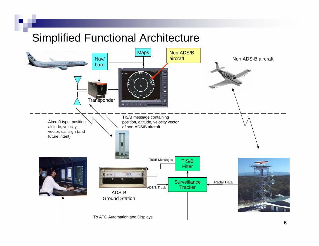
Surveillance –Provides aircraft type, position, altitude, velocity vector, call sign (and future intent)
BroadcastData transmitted for reception by airborne and ground receivers
ADS-B is an Air-Derived vs. Ground-Derived surveillance method.

4
ADS-B Functional TerminologyADS-B Surveillance
SBS service receives position broadcasts from ADS-B equipped aircraft and distributes this information to ATC automation systems to provide separation assurance and traffic flow management.
ADS-R (Rebroadcast)SBS service receives ADS-B position broadcasts and rebroadcasts that information to aircraft in the vicinity equipped with a different ADS-B link. ADS-R provides interoperability between aircraft equipped with other than ADS-B data links.
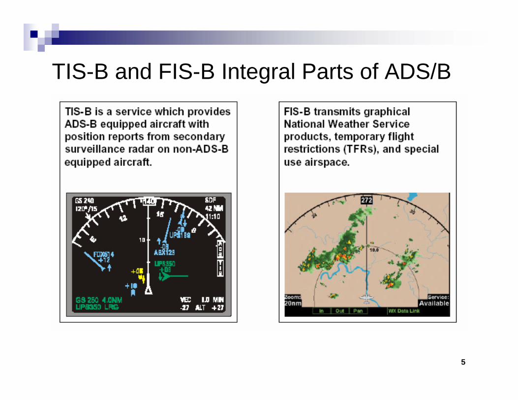
TIS-B – Traffic Information Services-BroadcastA surveillance service that derives traffic information from radar/sensor sources and uplinks the information to ADS-B equipped aircraft. TIS-B enables ADS-B equipped aircraft to receive position reports on non-ADS-B equipped aircraft until full transition to ADS-B enabled aircrafts.
FIS-B – Flight Information Services-BroadcastUplink service that provides aeronautical and flight information such as textual and graphical weather reports and Notice to Airmen (NOTAMs).
5
TIS-B and FIS-B Integral Parts of ADS/B
6
Simplified Functional Architecture
SurveillanceTracker
TIS/BFilter
To ATC Automation and Displays
TIS/B Messages
Nav/baro
Radar Data
Aircraft type, position, altitude, velocity vector, call sign (and future intent)
TIS/B message containing position, altitude, velocity vector of non-ADS/B aircraft
ADS/B Track
Non ADS-B aircraftNon ADS/B aircraft
ADS-BGround Station
Transponder
Maps
7
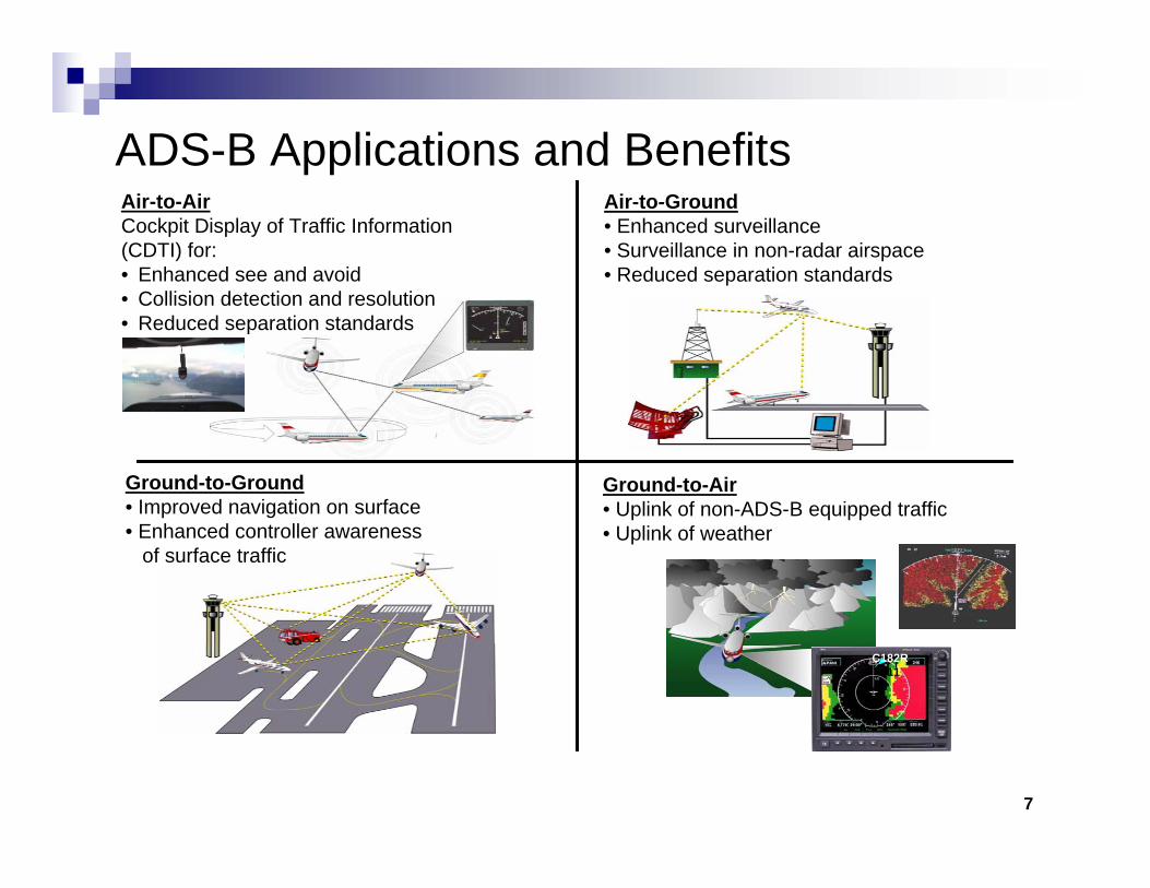
ADS-B Applications and BenefitsAir-to-AirCockpit Display of Traffic Information (CDTI) for:• Enhanced see and avoid• Collision detection and resolution• Reduced separation standards
Ground-to-Ground• Improved navigation on surface• Enhanced controller awareness
of surface traffic
Air-to-Ground• Enhanced surveillance• Surveillance in non-radar airspace• Reduced separation standards
Ground-to-Air• Uplink of non-ADS-B equipped traffic• Uplink of weather
C182R+11
Data Flow and Testing
Verification and Validation

9
Data-driven TestingVerification Testing:
Ensures that the services meet the customers requirements as specified. Could be characterized by the question: Are we receiving the target’s track, position and status data we expected?
Validation Testing:Ensures that the services meet the needs of the customers requirements. Could be characterized by the question: Are we confident that we are receiving the appropriate target’s track, position and status data that validates the radar or sensor data?
Translation: Increased Confidence Factor

10
Data-Driven Test ScenariosCreate scenarios with simulated data
Way points established based on test case requirementsTrack data originating from disparate data sources based on the established way pointsAdaptable tolerances to accurately represent a ‘real-world’ look and feel of ADS-B data and track data from existing radar sitesBenefits of simulated data
Alternative to Live DataVery predictable and accurate
Tight control over details of the test caseRepeatable scenarios that can be adjusted as necessary

11
Simplified Data Flow
CAT 33 – PositionCAT 23 - StatusOne ADS-B ReportPer Aircraft
CAT 34 - PositionCAT 48 - Status
CAT 33 – PositionCAT 23 - StatusMultiple coverage possible
TIS-B ServerTIS-B Server
CAT 62 –Track Information
CD-2 / ASR Data
ADS-B Radio(Aircraft)
ADS-B Radio(Aircraft)
Ground Based Transceiver (GBT)
Ground Based Transceiver (GBT) ADS-B ServerADS-B Server CD-2/ASR Radar SiteCD-2/ASR Radar Site
Service Delivery Point (SDP)
Service Delivery Point (SDP)
Multi-sensor Tracker(MST)
Multi-sensor Tracker(MST)

12
High Level Test Architecture
Multi-sensor Tracker(MST)
Multi-sensor Tracker(MST)
ADS-B ServerADS-B Server
CAT 33 – PositionCAT 23 - StatusOne ADS-B ReportPer Aircraft
CAT 34 - PositionCAT 48 - Status
CAT 33 - PositionCAT 23 - StatusMultiple coverage possible
Data Generation Tool Suite
Data Generation Tool Suite
Data Generation Tool Suite
Data-driven Test Scenarios to date have mainly centered on -
CD-2/ASR Radar SiteCD-2/ASR Radar Site
Service Delivery Point (SDP)
ADS-B Radio(Aircraft)
ADS-B Radio(Aircraft)
Ground Based Transceiver (GBT)
Ground Based Transceiver (GBT)
Service Delivery Point (SDP)
Service Delivery Point (SDP)
CD-2 / ASR Data
ADS-B ServerDisplay Systems
Multi-sensor Tracker (MST)
Emulation and Simulation

14
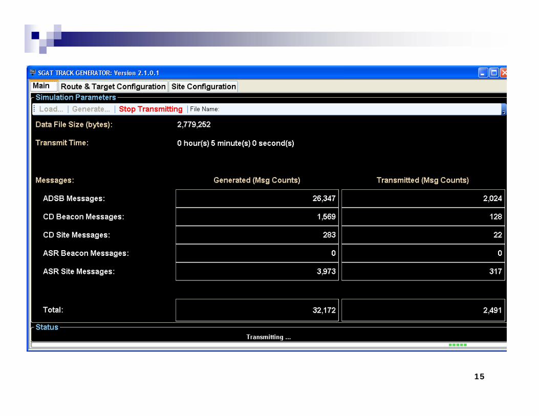
Configurable Surveillance Track Emulation Tool for ADS-B and Radar
The Surveillance Generation and Analysis Tool (SGAT) Track Generator
Supports legacy radar data, ADS-B, and correlated (ADS-B/radar) target information with the ability to simulate high data loads, alerts, and excessive targetThe SGAT Track Generator can auto-generate surveillance tracks based on user-specified site, route, and target information and is capable of saving this information for scenario creation and future playback. Currently being used by the FAA to test ADS-B development.The SGAT Track Generator is a proven tool for correlated track data testing.
15
16
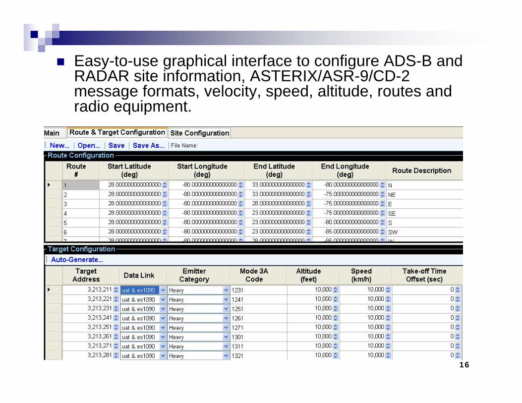
Easy-to-use graphical interface to configure ADS-B and RADAR site information, ASTERIX/ASR-9/CD-2 message formats, velocity, speed, altitude, routes and radio equipment.

17
Create specific targets using the Target Configuration screen or auto-generate targets using pre-defined routes and offsets for Target IDs, Target addresses, altitude and speed.Targets will fly routes within start/end longitude & latitude using configurable speed and altitudes.Designed for Stress TestingUnique target settings allow fault and threshold testing:Load thousands of tracks into a single areaSimulate excessive plane speed thresholdsSimulate loss of altitudeTransmit Emergency beacons

18
Advanced Target Settings:Allows fault injection (alarms) at varying time offsets for each configured radar site. The SGAT Track Generator automatically transmits the alarm bits at the designated intervals on a per site basis.
19
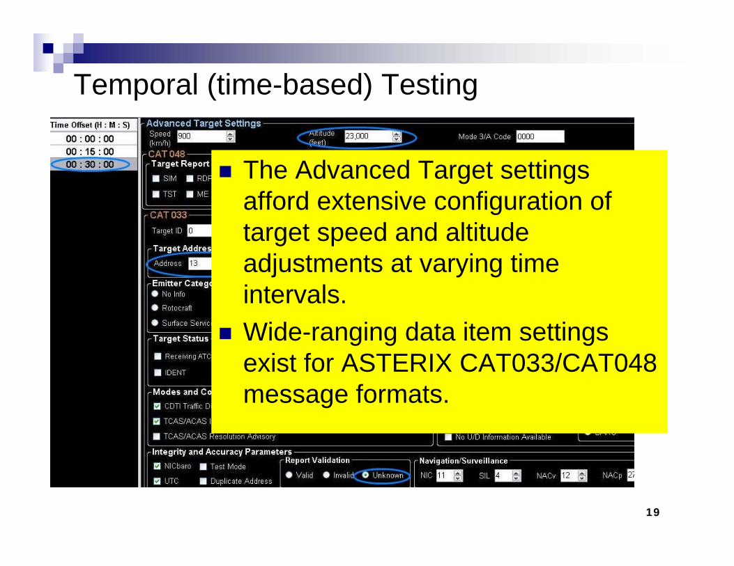
Temporal (time-based) Testing
The Advanced Target settings afford extensive configuration of target speed and altitude adjustments at varying time intervals.Wide-ranging data item settings exist for ASTERIX CAT033/CAT048 message formats.

20
Flexible and Scalable
CAT048 Data ItemsTarget Report Descriptors (incl.Type and Friend/Foe)Miss Beacons
CAT033 Data ItemsTarget AddressEmitter CategoryTarget StatusVelocity codesNavigation/Surveillance
21
Technical Merits and Benefits
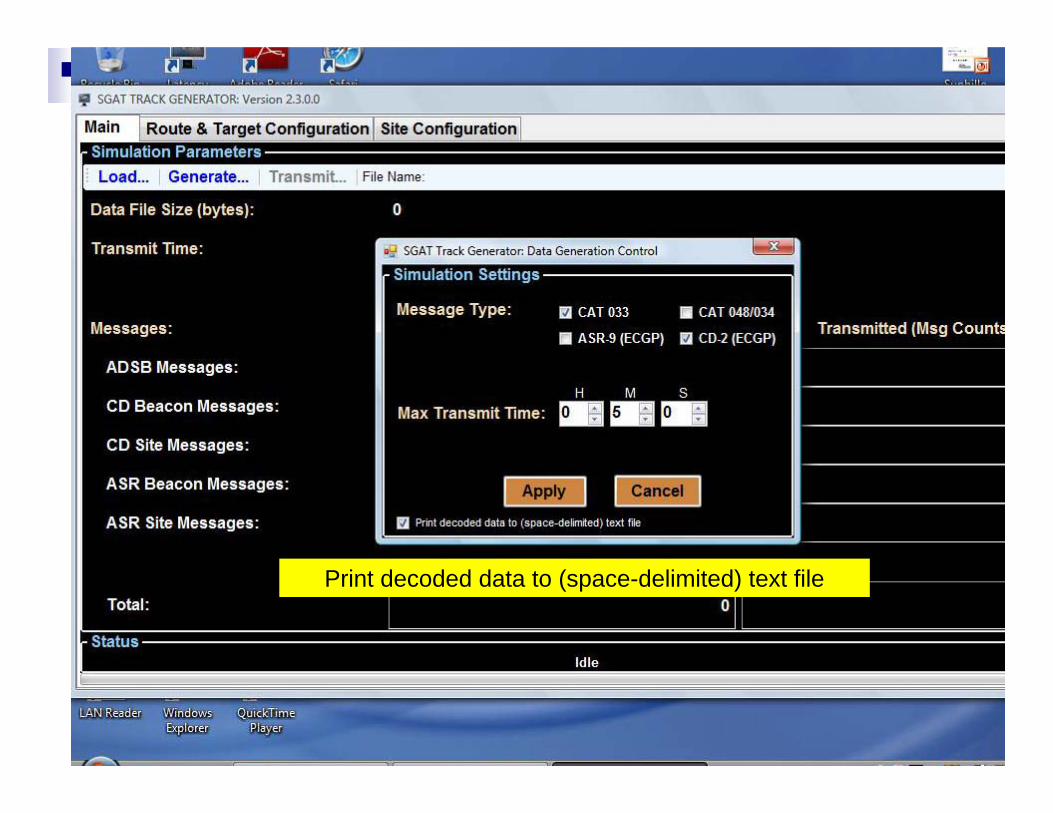
Print decoded data to (space-delimited) text file

22
Technical Merits and Benefits

23
Technical Merits and Benefits
24
Technical Merits and Benefits
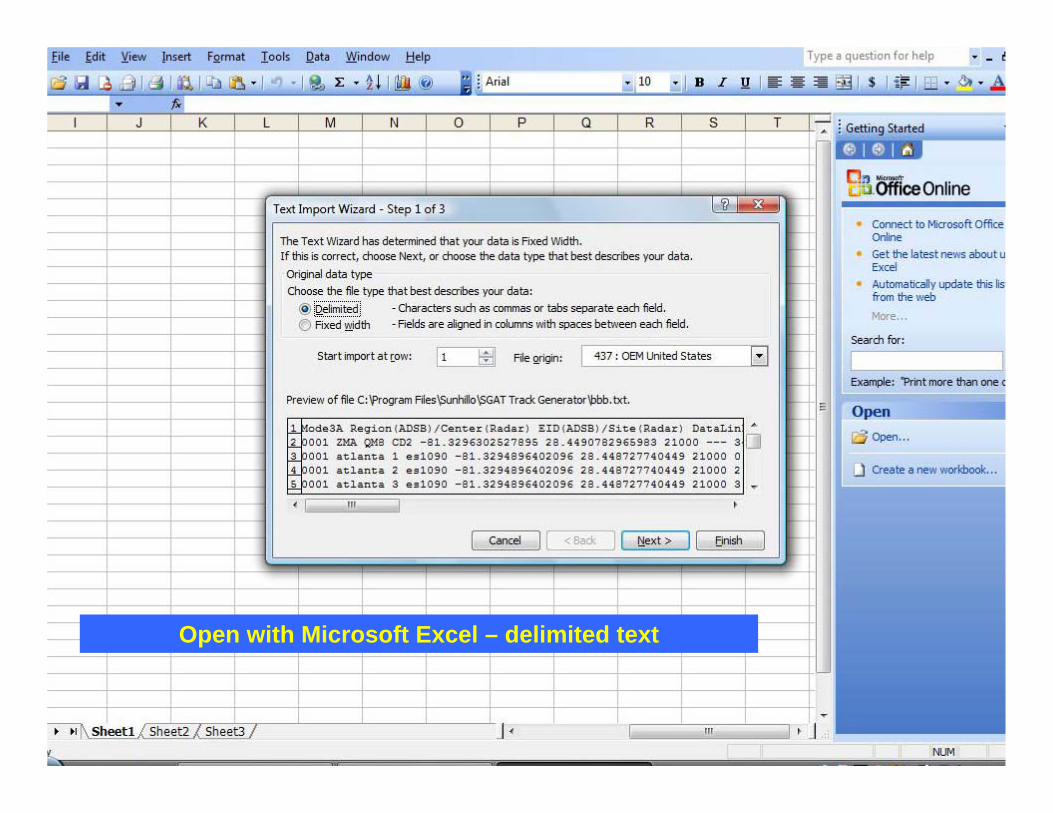
Open with Microsoft Excel – delimited text
25
Technical Merits and Benefits
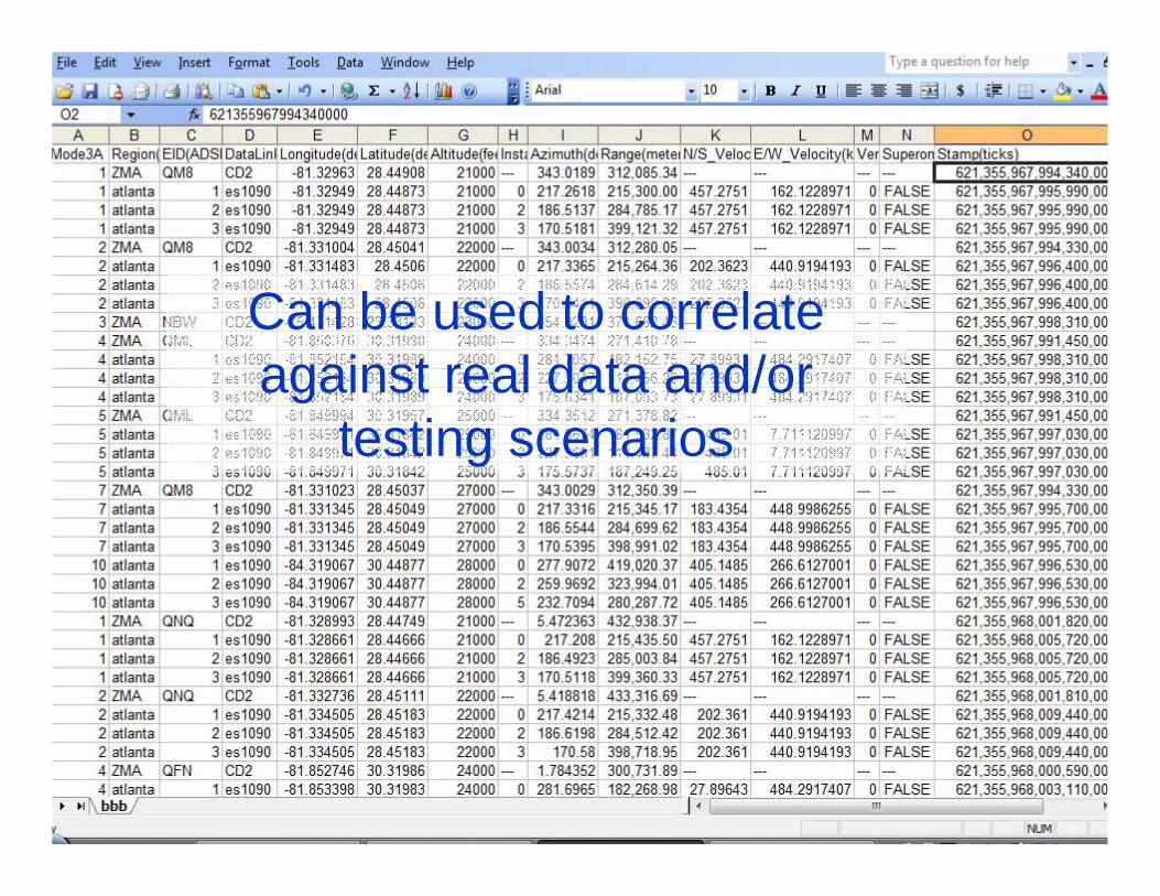
Can be used to correlate against real data and/or
testing scenarios

26
Simulation - SGAT File Player Tool

27
Technical Merits and Benefits
28
Technical Merits and Benefits
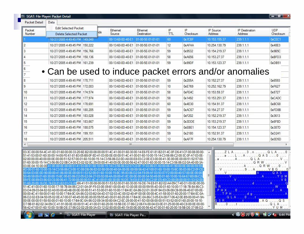
• Can be used to induce packet errors and/or anomalies
29
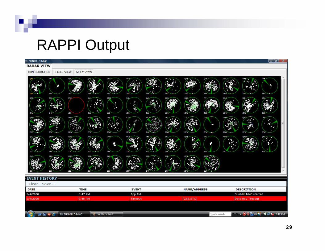
RAPPI Output
Applications and Benefits
31
Technical Merits and Benefits
ADS-B Data Certification Compare to Existing Radar
Quality of ServiceAccuracyReliability

Secondary Applications

33
Secondary Applications: ExamplesPreemptively found potential parsing issues with data
e.g., assumption that CAT33 used one signal quality level
WGS84 (World Geodetic System 1984) IssueSpherical representation vs. flat planeGeodetic datums define the size and shape of the earth and the origin and orientation of the coordinate systems used to map the earth. Hundreds of different datums have been used to frame position descriptions since the first estimates of the earth's size were made by Aristotle. Datums have evolved from those describing a spherical earth to ellipsoidal models derived from years of satellite measurements.

Questions?
Top Related