


Languages
Pages
Legal

#*
#*
#*
#*
#*
#*
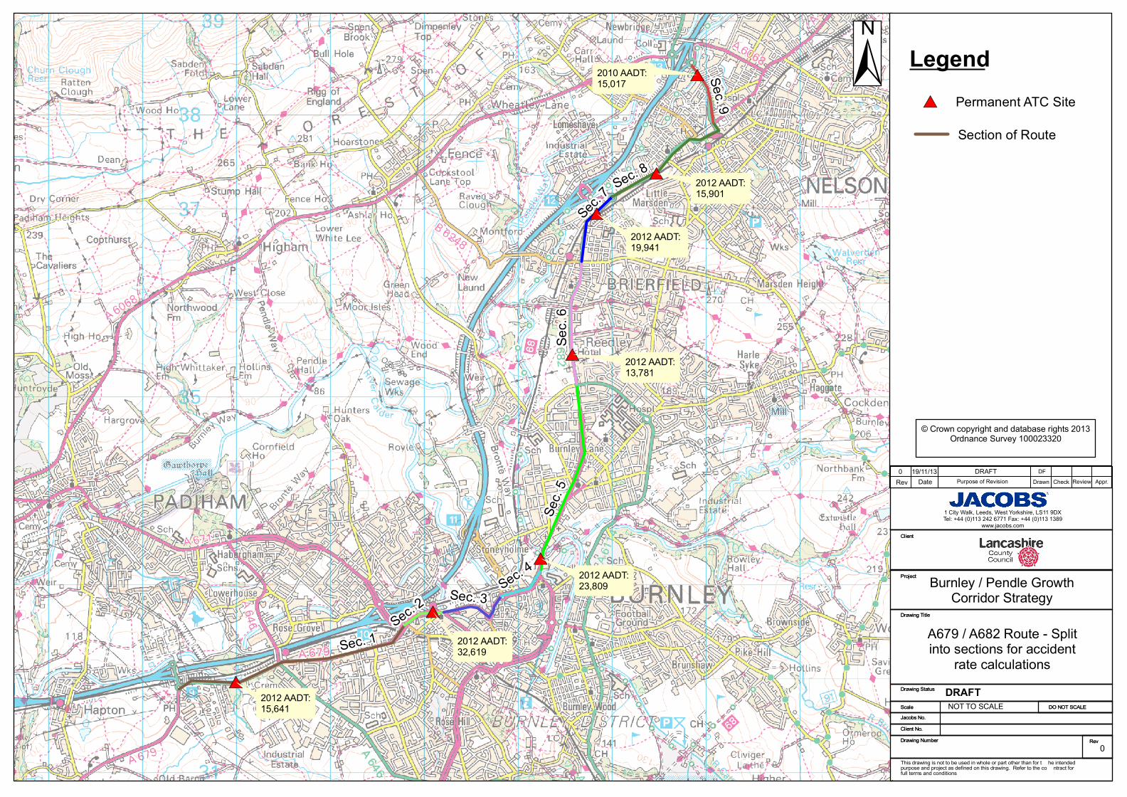
#*2012 AADT:15,641
2012 AADT:32,619
2012 AADT:23,809
2010 AADT: 15,017
2012 AADT:15,901
2012 AADT: 19,941
2012 AADT:13,781
Sec. 1
Sec.
5
Sec. 8
Sec.
6
Sec. 7
Sec. 9
Sec. 3Sec. 4
Sec. 2
Horsley House, Regent Centre, Gosforth , Newcastle upon Tyne NE3 3TZTel: 0191 213 4900 Fax: 0191 213 5177
www.jacobsconsultancy.co.uk
Client
Project
Drawing Title
Drawing Status
ScaleJacobs No.Client No.Drawing Number Rev
DO NOT SCALE
Horsley House, Regent Centre, Gosforth , Newcastle upon Tyne NE3 3TZTel: 0191 213 4900 Fax: 0191 213 5177
www.jacobsconsultancy.co.uk
Client
Project
Drawing Title
Drawing Status
ScaleJacobs No.Client No.Drawing Number Rev
DO NOT SCALE
Burnley / Pendle GrowthCorridor Strategy
NOT TO SCALE
This drawing is not to be used in whole or part other than for t he intended purpose and project as defined on this drawing. Refer to the co ntract for full terms and conditions
Rev Date Drawn Check Review Appr.
1 City Walk, Leeds, West Yorkshire, LS11 9DXTel: +44 (0)113 242 6771 Fax: +44 (0)113 1389
www.jacobs.com
© Crown copyright and database rights 2013Ordnance Survey 100023320
Purpose of Revision
±
A679 / A682 Route - Splitinto sections for accident
rate calculationsDRAFT
19/11/130 DRAFT DF
Legend
0
#* Permanent ATC Site
Section of Route
Originator: Adam James 28/11/2013
Checker: Daragh Foley 29/11/2013
East Lancs Connectivity Study - Burnley to Pendle Corridor
A679/A682 Route - Accident Rate Calculation
1. Purpose
To compare the observed number of accidents on the A679/A682 route with the number predicted by published default accident rates.
2. Methodology
The observed number of Personal Injury Accidents (PIAs) was compared with the number of PIAs predicted by national default accident rates.
This analysis was undertaken on the A679/A682 route between the junction with the M65 J9 and M65 J13 near Nelson.
National default accident rates were taken from COBA, the industry-standard DfT software for predicting accident numbers during transport appraisals.
COBA accident rates vary depending on the speed limit of the road and its classification (e.g. Modern Dual-Carriageway, Motorway, Older Single-Carriageway).
This analysis therefore involved splitting the A679/A682 route into several different sections, depending on its characteristics.
Accident rates in COBA are quoted in accidents per million vehicle-kilometres (Veh-Km). Veh-km are derived by multiplying the length of a road by its flow.
To derive the number of predicted accidents it is therefore necessary to know the Veh-Km - this is simply the length of road multiplied by its flow.
The length of each of section of road was measured using Google Earth, and the flow was extracted from Automatic Traffic Count (ATC) sites at the locations shown in Figure X.
The ATC flow data, which is shown in Table 2, was provided in Average Annual Daily Traffic Flow (AADT) - this was multiplied by 365 to derive the traffic over a whole year.
TABLE 1 TABLE 2 - ATC 2010 AADT flows
Section RoadSpeed Limit Distance (km) (A)
Representative
ATC Site ID
2-way AADT Flow
(B)
Annual Veh-Km (C = A x
B x 365) ATC site NB SB Combined
1A679 Accrington Road (M65 Jct
9 to Cavalry Way rbt)30/40mph 2.6 5108 15716 14,910,452 5108 7654 8062 15716
2A671 Westway (Cavalry Way
rbt to Trafalgar St)30mph 0.5 2742 33488 5,573,840 2742 17754 15734 33488
3A679 Westgate (Trafalgar St to
Royle Rd rbt)30mph 0.8 2038 20441 5,927,565 2038 11362 9079 20441
*Oct 2013 data used
4A679 Active Way Royle Rd rbt
to Church St)30mph 0.5 2038 20441 4,074,097 2038 11362 9079 20441
*Oct 2013 data used
5A682 Colne Rd (Church St to
Casterton Ave)30mph 2.1 5580 23739 17,818,438 5580 11590 12149 23739
6A682 Colne Rd (Casterton Ave
to Halifax Rd)30mph 1.3 6418 13630 6,677,791 6418 6946 6683 13630
7A682 Colne Rd (Halifax Rd to
Churchill Way)30mph 0.8 5928 19616 5,790,545 5928 10226 9390 19616
*2009 used due to missing data in 2010 &2011
8A682 Manchester Rd (Churchill
Way to Leeds Rd)30mph 1.5 3258 15576 8,368,947 3258 8057 7519 15576
*2011 used due to missing data in 2010
9A682 New Scotland Rd (Leeds
Rd to M65 Jct 13)30mph 0.7 3270 15017 3,610,055 3270 7884 7133 15017
The purpose of this analysis was to compare the predicted number of accidents with the observed number of accidents. Observed accident data was collected for 5 years between 2008 and 2012.
To compare, it was therefore necessary to calculate how many accidents would be predicted to occur over 5 years based on COBA's accident rates.
To derive this, the 5-year Veh-Km for each section of road was multiplied by the relevant COBA accident rate (taken from Table 4/1 in Part 2 of the COBA manual). This is calculated in Table 3, below.
Note that COBA accident rates are based on data from 2000, but is known that accident rates fall over time. COBA therefore provides factors to convert from 2000 accident rates to rates for any other year.
These factors are provided in Table 4/1 of the COBA manual, with the methodology stating how to use these factors directly preceding the table.
As the observed accident rate was based on 2008-2012 data, COBA accident rates were calculated for 2010 (the central year of 2008-2012).
TABLE 3 - Predicted and Observed Accident Numbers
Section RoadAnnual Veh-Km
(from Table 1) (A)
5 year Veh-km (B
= A x 5)
Road Type (see
Table 4/1 in Pt. 2 of
the COBA manual)
Default Acc Rate per
mvkm (2000 base)
Default Acc Rate per
mvkm (2010) ( C )
Predicted Accidents
over 5 years (D = B x
C)
Observed
Accidents
over 5 years
1A679 Accrington Road (M65 Jct
9 to Cavalry Way rbt)14,910,452 74,552,259 Older A S2 Road 0.844 0.718 54 35 -19
2A671 Westway (Cavalry Way
rbt to Trafalgar St)5,573,840 27,869,199 Older D2 Road 1.004 0.854 24 14 -10
3A679 Westgate (Trafalgar St to
Royle Rd rbt)5,927,565 29,637,825 Older A S2 Road 0.844 0.718 21 21 0
4A679 Active Way Royle Rd rbt
to Church St)4,074,097 20,370,486 Older D2 Road 1.004 0.854 17 22 5
5A682 Colne Rd (Church St to
Casterton Ave)17,818,438 89,092,190 Older A S2 Road 0.844 0.718 64 93 29
6A682 Colne Rd (Casterton Ave
to Halifax Rd)6,677,791 33,388,957 Older A S2 Road 0.844 0.718 24 32 8
7A682 Colne Rd (Halifax Rd to
Churchill Way)5,790,545 28,952,726 Older A S2 Road 0.844 0.718 21 21 0
8A682 Manchester Rd (Churchill
Way to Leeds Rd)8,368,947 41,844,733 Older A S2 Road 0.844 0.718 30 41 11
9A682 New Scotland Rd (Leeds
Rd to M65 Jct 13)3,610,055 18,050,273 Older A S2 Road 0.844 0.718 13 31 18
TOTAL 268 310 42
COBA can also be used to predict the severity of accidents. Table 4 calculates how many accidents are predicted to fall within each class of severity (fatal, serious and slight). This is based on proportions taken from Table 3/2 of Part 2 of the COBA manual.
In a similar way to the change in accident numbers over time discussed above, the severity of accidents also changes over time.
Table 4 calculates the number of accidents of each severity type based on data from 2000, then adjusts these to 2010 proportions based on the factors in Table 4/1 of Pt 2 of the COBA manual.
The methodology stating how to use these factors are found in paragraph 3.3 of Pt 2 of the COBA manual.
TABLE 4 - Predicted and Observed Accident Numbers by Severity
SectionPredicted Accidents over 5
years (from Table 3)
Predicted Fatal Accs
(based on 2000
severity proportions)
Predicted Serious
Accs (based on
2000 severity
proportions)
Predicted Slight
Accs (based on
2000 severity
proportions)
Predicted Fatal
Accs (based on
2010 severity
proportions)
Predicted Serious
Accs (based on 2010
severity proportions)
Predicted Slight
Accs (based on 2010
severity proportions)
Observed
Fatal Accs
Observed
Serious Accs
Observed Slight
Accs
1 54 0 7 47 0 6 48 1 5 29
2 24 0 3 21 0 3 21 0 0 14
3 21 0 3 18 0 3 18 0 4 17
4 17 0 2 15 0 2 15 0 1 21
5 64 1 8 55 1 7 56 0 12 81
6 24 0 3 21 0 3 21 1 4 27
7 21 0 3 18 0 3 18 0 3 18
8 30 0 4 26 0 3 27 0 2 39
9 13 0 3 10 0 3 10 0 6 25
TOTAL 268 1 36 231 1 31 237 2 37 271
3. Results
A summary of the 2008-2012 predicted and observed accident rates is provided in Table 4, below.
TABLE 4 - SUMMARY OF 2008-2012 PREDICTED AND OBSERVED ACCIDENT RATES
Total
Accidents
Fatal
Accidents
Serious
Accidents
Slight
Accidents
Predicted 268 1 31 237
Observed 310 2 37 271
P:\B2000000\B2237506 - ELCS\Burnley Pendle Corridor\3 JC Tech Work\3.1 Transportation\3.1.1 Calculations\Accident Data\A679_A682 Route - Predicted vs Observed Accidents.xls
Top Related