


Languages
Pages
Legal


1
-
A History of the Cemetery at the Albuquerque Indian School
By Joe Sabatini
Archives and Library Volunteer
Indian Pueblo Cultural Center
July 17, 2017; Addendum on September 24, 2017
The Albuquerque Indian School (AIS) was established in 1881 and moved to its permanent 66 acre site
at 12th and Menaul Blvd. NW around 1884. In its first forty years, a substantial majority of its students
were from the Pueblos. Even into the 1930s, Pueblos made up about half of the student body, with most
of the remaining students from neighboring southwestern tribes. At the beginning, AIS took mostly
elementary grade children. Over time, as the Indian Bureau created Day Schools on various reservations,
AIS increasingly served older students. By the time it closed in 1981, it was solely a high school. At its
busiest, AIS had between 1,000 and 1,200 students in the 1930s.
2
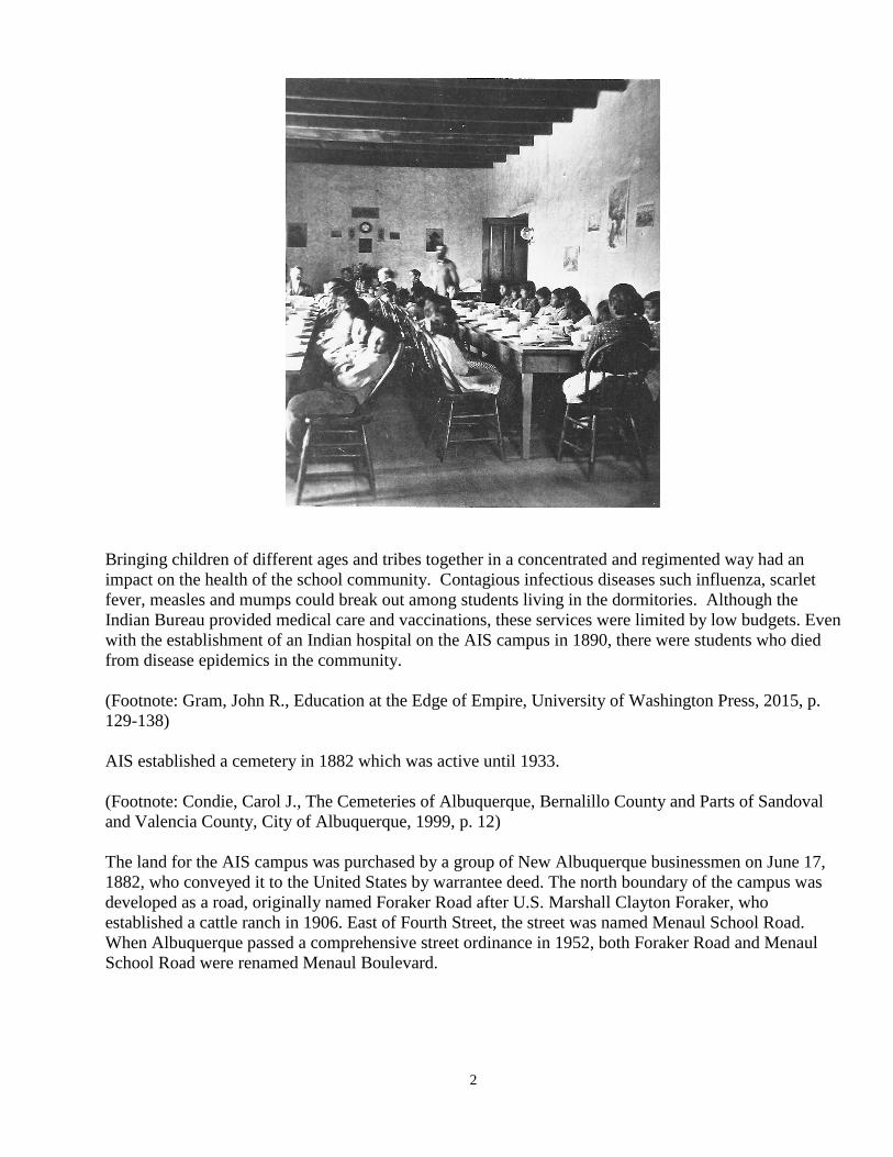
Bringing children of different ages and tribes together in a concentrated and regimented way had an
impact on the health of the school community. Contagious infectious diseases such influenza, scarlet
fever, measles and mumps could break out among students living in the dormitories. Although the
Indian Bureau provided medical care and vaccinations, these services were limited by low budgets. Even
with the establishment of an Indian hospital on the AIS campus in 1890, there were students who died
from disease epidemics in the community.
(Footnote: Gram, John R., Education at the Edge of Empire, University of Washington Press, 2015, p.
129-138)
AIS established a cemetery in 1882 which was active until 1933.
(Footnote: Condie, Carol J., The Cemeteries of Albuquerque, Bernalillo County and Parts of Sandoval
and Valencia County, City of Albuquerque, 1999, p. 12)
The land for the AIS campus was purchased by a group of New Albuquerque businessmen on June 17,
1882, who conveyed it to the United States by warrantee deed. The north boundary of the campus was
developed as a road, originally named Foraker Road after U.S. Marshall Clayton Foraker, who
established a cattle ranch in 1906. East of Fourth Street, the street was named Menaul School Road.
When Albuquerque passed a comprehensive street ordinance in 1952, both Foraker Road and Menaul
School Road were renamed Menaul Boulevard.

3

4
5
(Footnote: State of New Mexico Property Map, Middle Rio Grande Conservancy District Bernalillo
County Maps 035 and 036, 1927. In MRGCD Historical Archives)
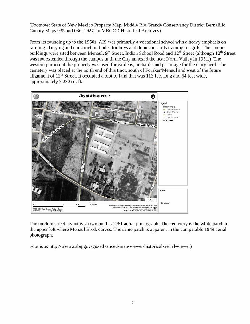
From its founding up to the 1950s, AIS was primarily a vocational school with a heavy emphasis on
farming, dairying and construction trades for boys and domestic skills training for girls. The campus
buildings were sited between Menaul, 9th Street, Indian School Road and 12th Street (although 12th Street
was not extended through the campus until the City annexed the near North Valley in 1951.) The
western portion of the property was used for gardens, orchards and pasturage for the dairy herd. The
cemetery was placed at the north end of this tract, south of Foraker/Menaul and west of the future
alignment of 12th Street. It occupied a plot of land that was 113 feet long and 64 feet wide,
approximately 7,230 sq. ft.
The modern street layout is shown on this 1961 aerial photograph. The cemetery is the white patch in
the upper left where Menaul Blvd. curves. The same patch is apparent in the comparable 1949 aerial
photograph.
Footnote: http://www.cabq.gov/gis/advanced-map-viewer/historical-aerial-viewer)

6
(
It is also visible in the 1938 aerial photograph with the view looking north towards Los Griegos with the
Indian School in the foreground.
(Footnote: Photo by 3-Hawks ,# 100, University of New Mexico. Center for Southwest Research.
Laurens C. Bolles Photograph Collection, #000-493-0128)
As AIS phased out its vocational agriculture programs in the late 1950s, the farm tract west of 12th Street
was no longer needed. This was during the “termination” era of federal Indian policy. On April 25,
1960, the Bureau of Indian Affairs (B.I.A.) conveyed a 7 acre parcel of land at the north end of the tract
to Bernalillo County. The County built an office to house the N.M.S.U. County Extension office, and
leased part of the property to the 4-H Building Corporation on December 28, 1960 to establish a 4-H
Center and rodeo grounds. Other land transactions occurred between the B.I.A, the City of
Albuquerque, Bernalillo County and the Building Corporation in the next few years, resulting in the
creation of a new diagonal street, Menaul Extension, which connected Menaul Blvd. to Indian School
Road. The old route of Menaul Blvd. west of 12th Street was adjusted to fork off of Menaul Extension
next to the AIS Cemetery. The City sub-leased the 2.95 acre triangular plot north of Menaul Extension
from the 4-H Building Corporation on November 4, 1963, originally for a tree nursery, and later for a
public park, 4-H Park.
(Footnote: License No. 36695 Concerning Use of Land – Tree Nursery and Related Purposes. January 9,
1967. In Solar Arc files at City of Albuquerque Public Arts Program.)
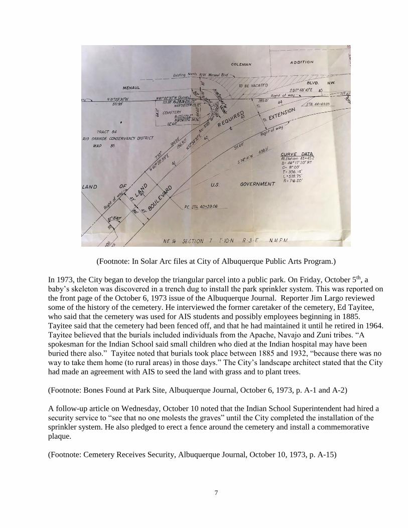
The exact location and dimensions of the cemetery are documented in a City survey map done in April,
1962 and signed on May 10, 1962, in which Gordon Herkenhoff Engineers certified the right of way
required to build Menaul Extension.
7
(Footnote: In Solar Arc files at City of Albuquerque Public Arts Program.)
In 1973, the City began to develop the triangular parcel into a public park. On Friday, October 5th, a
baby’s skeleton was discovered in a trench dug to install the park sprinkler system. This was reported on
the front page of the October 6, 1973 issue of the Albuquerque Journal. Reporter Jim Largo reviewed
some of the history of the cemetery. He interviewed the former caretaker of the cemetery, Ed Tayitee,
who said that the cemetery was used for AIS students and possibly employees beginning in 1885.
Tayitee said that the cemetery had been fenced off, and that he had maintained it until he retired in 1964.
Tayitee believed that the burials included individuals from the Apache, Navajo and Zuni tribes. “A
spokesman for the Indian School said small children who died at the Indian hospital may have been
buried there also.” Tayitee noted that burials took place between 1885 and 1932, “because there was no
way to take them home (to rural areas) in those days.” The City’s landscape architect stated that the City
had made an agreement with AIS to seed the land with grass and to plant trees.
(Footnote: Bones Found at Park Site, Albuquerque Journal, October 6, 1973, p. A-1 and A-2)
A follow-up article on Wednesday, October 10 noted that the Indian School Superintendent had hired a
security service to “see that no one molests the graves” until the City completed the installation of the
sprinkler system. He also pledged to erect a fence around the cemetery and install a commemorative
plaque.
(Footnote: Cemetery Receives Security, Albuquerque Journal, October 10, 1973, p. A-15)

8
There was no indication in either of the Journal articles about any plan to relocate the burials. In 1999
the City contracted with Carol Condie of Quivira Research to locate and describe the active and inactive
cemeteries in the metropolitan area. The entry for the AIS cemetery reads:
(Footnote: Condie, Carol J., The Cemeteries of Albuquerque, Bernalillo County and Parts of Sandoval
and Valencia County, City of Albuquerque, 1999, p. 7)
The photo in figure 18 shows the plaque that was installed. This plaque is presently (2016) located on
the grass adjacent to the sidewalk on the south side of Menaul Blvd.
(Footnote: Condie, Carol J., The Cemeteries of Albuquerque, Bernalillo County and Parts of Sandoval
and Valencia County, City of Albuquerque, 1999, p. 50)

9
Photos by the author.

10
In 1992, the University of New Mexico asked the City to relocate the Solar Arc, a public art sculpture
that had been installed at the northwest corner of Central and Girard NE. The City’s Public Art Program
staff initiated a competition to determine a new location for the Solar Arc, soliciting applications from
neighborhood associations. The application of the Near North Valley/Old Indian School Neighborhood
Association to have it placed in 4-H Park was selected, and the sculpture was installed and dedicated on
November 8, 1995. During the public process, the existence of the cemetery is noted in discussion of
the siting of the Solar Arc. During the dedication ceremony, Dr. Joe Sando, representing the Indian
Pueblo Cultural Center, spoke about the cemetery. A quotation from his remarks was included on the
plaque describing and explaining the Solar Arc.
Photo by the author.
“In honor of former Albuquerque Indian School students interred in the burial ground nearby.
‘Few are recalled after going to rest as these resting here. Indeed, they are in peace.’ Joe Sando”

11
There is a substantial file of documents at the City’s Public Arts Program relating to the Solar Arc in
which the location of the Cemetery is mentioned in discussions about the best location to place the Solar
Arc. There is a document in which City Chief Administrative Officer Lawrence Rael noted that the
Cemetery was active from 1888 to 1930. In planning the location for the Solar Arc, the Public Arts
Program staff determined to place it at “Site B”. Note, in the diagram below, the location of trees around
the perimeter of the cemetery boundaries. The cemetery site is not conducive to recreational activities.
There is an established children’s playground at the northwest corner of the park. There are picnic tables
along the west edge of the park by Sioux Street. The large open area in the center is frequently used by
youth football and soccer teams. Intentionally or not, it seems as though the park planners designed the
landscape so that the former cemetery would not attract active use.
(Footnote: In Solar Arc files at City of Albuquerque Public Arts Program.)
12
Photos by the author.
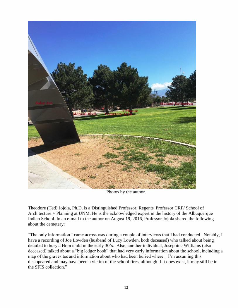
Theodore (Ted) Jojola, Ph.D. is a Distinguished Professor, Regents' Professor CRP/ School of
Architecture + Planning at UNM. He is the acknowledged expert in the history of the Albuquerque
Indian School. In an e-mail to the author on August 19, 2016, Professor Jojola shared the following
about the cemetery:
“The only information I came across was during a couple of interviews that I had conducted. Notably, I
have a recording of Joe Lowden (husband of Lucy Lowden, both deceased) who talked about being
detailed to bury a Hopi child in the early 30’s. Also, another individual, Josephine Williams (also
deceased) talked about a “big ledger book” that had very early information about the school, including a
map of the gravesites and information about who had been buried where. I’m assuming this
disappeared and may have been a victim of the school fires, although if it does exist, it may still be in
the SFIS collection.”

13
In another e-mail on July 20, 2017, he reported: “the three sieges among the young AIS kids were
Malaria (when the campus was still largely a swamp), the Spanish Flu (I have an amazing IHS report on
that for Isleta) and TB (thanks to the eastern gringos)! So, in my interview with Joe Lowden, he made
mention that the policy with deaths was to send the child back to their community. However, as in the
case of Hopi, some communities would not allow the child back because they were afraid that the child
was still infected. So tragic! “
Addendum to Jojola Remarks on July 20, 2017
“In my conversation with Alana [McGrattan, former AIS and SFIS librarian], she said that SFIS is now
establishing standards for making their historic records available for public use! She said that in her
conversations during the Joe Abeita regime, he had made mention that they received and sequestered
several old ledger books from AIS. These were kept in a vault in a basement for safe keeping. Then the
basement was flooded during a bad storm and all these documents were destroyed. So sad. We'll never
know I guess!”
After AIS was closed in 1981, there were no resources to protect the remaining buildings on the campus.
Gradually, vagrants began to occupy these buildings. During the winters, they would empty files to use
the papers as covers. They started fires, which destroyed several of the buildings. In 1992, the
remaining buildings were razed. Most of the records from the school were lost during this period. It is
likely that among the lost records was any registry of the names of the individuals buried in the
cemetery.
Addendum of June 4, 2019 by Joe Sabatini
The sidewalk plaque was stolen sometime in January 2019. Marit Tully of the Near North Valley
Neighborhood Association advised me that her husband Andy Thomas noticed it was missing, and
reported it to Indian Pueblo Cultural Center/IPMI CEO Mike Canfield. (Andy Thomas was president of
the Association when it successfully bid on relocating the Solar Arc to 4-H Park.) It seems highly likely
that the bronze plaque was stolen for its value as scrap metal. This has become a common occurrence, as
noted by the transcript of the following television news story.
KRQE Channel 13
Albuquerque-Metro
Nearly 50 plaques have been stolen in Albuquerque over last decade
By: Rebecca Atkins
Posted: Apr 12, 2019 05:50 PM MDT
Updated: Apr 13, 2019 02:11 PM MDT
ALBUQUERQUE, N.M. (KRQE) - They're here for your viewing pleasure—plaques all over the city,
providing a glimpse into history.
"One of the neighbors called me and said the plaques are gone," said Harvey Buchalter.

14
In the Huning Castle Neighborhood near the country club, two expensive brass plaques were taken last
November.
"This is a historic area, and these plaques were lessons about what the neighborhood was and what the
neighborhood is," said Buchalter, President of the Huning Castle Neighborhood Association.
The plaques had pictures of the castle, along with a description of the Huning family—but now, those
plaques are gone.
"We're very, very sad. It's taking a piece of our heritage away," Buchalter said.
The city said the two Huning Castle Plaques are among the 45 or so citywide that have disappeared over
the past decade.
"These plaques cost just over $1,000 apiece and they are recyclable, and as a result of the fact that
would-be thieves could potentially make some money off of them, we believe that's the reason they've
become a target," said Johnny Chandler, city spokesperson.
One of the most recent thefts, Chandler said, were 15 bronze plaques from the lookout points on the
Montano bridge, also back in November.
"On those overlooks we put plaques talking about the Rio Grande and the history, and some of the
significant events that happened in this valley previously," said Chandler.
The plaques are still gone from the overlook today.
"They appear to have been stolen," he said.
Chandler said now the city is working to replace them with a new version made out of high-density
plastic—an unfortunate reality these days.
"To pick up a few dollars taking something that actually has value and utility for others...It's a sad
commentary," said Buchalter.
The city is still looking for a vendor for the new plaques along the Montano Bridge. Right now, it only
has plans to replace three of the 15.
Other stolen plaques around the city will be assessed if they will be replaced or not.
The Huning Castle Neighborhood is also looking to replace its plaque with a less valuable material.
Copyright 2019 Nexstar Broadcasting, Inc. All rights reserved. This material may not be published,
broadcast, rewritten, or redistributed.

15
Top Related