


Languages
Pages
Legal

A CRITICAL LOOK AT THE HISTORY, ETHNOGRAPHY,
AND LINGUISTICS OF WAPATO By Terry Spurgeon
We hear that a mass of Indians are now collected there, and that their women are busied in gathering Wappatoes [wapatos] a root of which they are particularly fond, and which is found under the water in Pools and Marshes. The Indians here call it Skous, tho' I have given it the name by which it is known on the Columbia.
George Barnston, The Fort Langley Journals 1827-30, (Maclachlan 1998:40)
Introduction In the previous issue of The Midden
basic information on the ecology of wapato and the context of my research was presented. Here a critical review is conducted of the ethnographic and historic data pertaining to wapato in order to provide a more understandable framework in which to study traditional Katzie use of wapato, and ultimately to set the stage for dealing with wapato in possible archaeological contexts. The need for this type of analysis should be self-evident, given the modem emergence of critical archaeology whose main tenets were derived from ethnography and history by archaeologists. Additionally, the frequent and uncritical use of ethnographic analysis and the direct historical approach to augment or initiate archaeological interpretations demands that greater attention be paid to critical review and the context of original sources to avoid perpetuating misleading interpretations.
Searching for Bias Recognition of bias is an important con
sideration in the process of critically reviewing the information available. Hammersley and Gomm (1997: 1.1) conclude that accusations of bias are a recurrent event in the social sciences. They make the point that in response to such accusations of bias there is often a countercharge that it is not the original research that is at fault, but it is the evaluation of the research that is biased. Bias exists in three main forms in their view: the first is "the adoption of a particular perspective
12 The Midden 34/1
from which some things become salient and others merge into the background"; secondly in reference to systematic error, or "deviation from a true score as a valid measurement of some phenomenon or to accurate estimation of some population parameter"; and lastly in a more specific form denoting a particular form of systematic error: "that deriving from an unconscious or conscious tendency on the part of the researcher to produce data, and/ or to interpret them, in a way that inclines towards erroneous conclusions which are in line with his 9r her commitments."
Communication in the form of verbal accounts, written records, and observed behaviour provide the basis upon which the historic and ethnographic information researchers use was recorded. Communication implies something in the way of information being transmitted from the source, and the reception of this information by the recorder. For the former the expectations of the enquirer may not always be fully understood, and for the latter understanding the information being transmitted may not always be clear. Subsequently, users of the recorded information also bring their biases and potential for misunderstanding into the process, often at great distances in time and space. Obviously the process is fraught with potential problems that must be addressed to ensure the veracity of the final record and subsequent interpretations. Assuming the process includes an informant and a recorder, for now leaving out the ultimate user, some of the problems are: (1) recorder qualifications-writing ability, Ian-
guage understanding; (2) recorder and informant comprehension-what is really meant? (3) informant knowledge and biases-gender, width of view (family, community), and validity; (4) informant distance in time from the activity being recorded; (5) distance in time from when the recording takes place from the activity being recorded; (6) translation problems-is a potato a potato? (7) do informants intentionally mislead or are they misinformed? (8) do recorders inject their biases and is the research itself biased?
Glavin (2000:7) puts the need to consider these numerous ramifications quite succinctly when he states "Sorting out the history of the North Pacific involves the business of considering questions not only about the observed but also about the observer and the observer's own culture and ideology." Analysis of the quotation at the start of this article serves to illustrate the potential problems attendant upon uncritically accepting information at face value from quotations taken from a variety of historic and ethnographic sources. Taken as a whole such sources offer something of value when studying wapato, but nearly all can be misleading. There are potential problems with subject, intent, context, recorder and informant bias, and many other issues. An excellent example is how the Barnston quote appears in different sources. The transcription by Macintosh (1963:26) of the original archival copy reads:
We hear that a mass of Indians are now collected there, but that most of them intend soon to clear out entirely for their lands, not to return again until next sum-
l
t r
I
mer. It appears that they procure, where they are at present, a great number of Wappatoes a root found under water in pools and marshes, and held by them in great estimation as an article of food. The name they give it here is Scous or rather Skous. On the Columbia it is known by the one first mentioned.
The Macintosh (1963) version does not attribute the entry to Barnston, implying that it is a journal entry by James MacMillan. Duff (1952:73) has essentially the same information, although he names the location as the "Forks" (of Pitt and Fraser rivers), whereas the Macintosh transcription of Barns ton refers to the location as "the forks below." It is the recent work of MacLachlan (1998:40) that attributes the entry to George Barnston and introduces the notion that women did the digging, although there is no mention of women doing the digging in the other versions. Several references to this passage refer to 5,000 Indians assembled at the confluence to dig skous on return from salmon fishing upriver (Suttles 1987:142 footnote 12; McKelvie 1947:33, 1991 :39) although no such figure exists in the original journal. It appears this number originates from an 1829 estimate in a separate report by a Hudson's Bay Chief Factor (Duff 1952:26; Murphy 1929:19). Overall, there is evidence here of bias, error, and interpretation, all added at later dates well removed from the original to enhance the quotation, notwithstanding that events may well have transpired each year as indicated. There is a hint here that one should take care in regard to the absolute veracity of such sources.
An important role of archaeology in addition to understanding the past is in providing historical perspective for understanding ethnographic data (Trigger 1989:336). Trigger indicates that anthropologists are coming to believe that "ethnologists and social anthropologists, whether studying social structure or change, are investigating the results of acculturation because their data are derived from small-scale societies that are either being destroyed or integrated ever more completely into the modem world system." H~ further notes that it is clear that no society can be properly understood or classified structurally unless its relationships with other societies is taken into account (Trigger 1989:336). This is an idea in consonance with Hodder ' s
(1991:143) overarching view of context. On the Northwest Coast bias at a high
level is quite evident in several forms. There is a bias in archaeological artifact preservation, where lithics dominate and faunal and floral remains are less successful in surviving the vagaries of taphonomic processes. The bias in artifact recovery results in the dominance of lithics analysis in reports, while faunal and especially floral analyses are less evident. Faunal analysis is more prevalent than botanical analysis, whith has only been emerging in the last decade as a major focus in research design, recovery, and interpretation (Lepofsky 2002). The traditional categorizing of hunter-gatherer bands and sedentary agricultural societies into separate entities is somewhat problematic on the Northwest Coast as sedentary collectors have more in common demographically, socially, and politically with agriculturalists than they do with most hunter-gatherers (Trigger 1989:399). Archaeology can lead to re-interpretation of misleading or erroneous information in historic and ethnological information, this being evident in the emergence of paleoethnobotany as a major force on the Northwest Coast (Lepofsky 2002; Lepofsky et al. nd.; Loewen 1998; Lyons 2000). The following quote best sums up the present situation regarding typical Northwest Coast ethnography:
When field notes were worked up into books, an academic datum plane was created: traditional Northwest Coast culture. If ethnographers asked their questions at the end of the nineteenth or early in the
twentieth century, as many of them .did, their informants remembered and descnbed early- to mid-nineteenth-century societies. This was the slice of time that ethnography transformed into timeless traditional culture (Harris 1997:28).
ffistoric and Ethnographic Impacts Affecting the Study of Wapato
The potential entry of myriad biases into the historic and ethnographic record regarding wapato must be accounted for. All of the possible entry points for misleading information or bias as noted are potentially at play when studying wapato in Katzie territory.
To properly conduct archaeological interpretations of wapato it is appropriate to use accepted archaeological methods to arrive at interpretations. Also, it is necessary to more fully pursue our understanding of the roots of our modem knowledge of wapato. The archaeological methods of paleoethnobotany should be directed at the matter. In conjunction, it is useful to address the numerous historic changes since contact that have influenced our present knowledge of wapato use and affect the potential to confidently use the direct historical approach or ethnographic analogy as methods to infer prehistoric practices. Table 1 presents post-contact influences that have regionally affected our modem understanding of this plant resource. The table presents the major influences in more or less chronological order from the present to early contact times and includes brief comments on
The Midden 34/1 13

each of the impacts listed. Accompanying these influences, especially since diking commenced, is a continuous disturbance to or loss of archaeological sites. Represented in the table is an almost continuous series of impacts with both onetime and cumulative effects such that any speculation about wapato must be tempered with at least one or more of these factors. For many traditional uses the local Native population was precluded from accessing significant portions of the landscape by land alienation, which, while distributing land first to speculators (Collins 1975) and later to settlers, excluded Native land ownership.
The continuous depredations of disease, estimated to have reduced pre-contact Native population levels by up to ninety percent, would have limited traditional uses. This factor, coupled with the relatively late or, depending on viewpoint, re~ent gathering of ethnographic data ( cf. Jenness 1955; Suttles 1955) raises questions about the accuracy of male-dominated information about female activities and the nature of what was being reported and its closeness to pre-contact practices. Suttles (1987:16 footnote 2) notes that personal recollections of the oldest informants did not date back earlier than the 1870s and 1880s, a situation that raises questions then about the potential archaeological significance of some ethnographic reconstructions. It has been pointed out to me by Katzie band members that the knowledge of one family group about wapato as reported in Suttles (1955) might not necessarily reflect that of another family group.
An exception to closeness in time would be The Fort Langley Journals: 1827-30 (Maclachlan 1998), which record activities during the AD 1827-1830 period, but have their own problems relating to the recorder's Old World colonial and cultural biases and their difficulties in understanding and writing Native languages (Suttles 1998). The accompanying new economic climate, where paid jobs, trade goods, and changed marke~s dominated, would have affected wapato use through the introduction of potato (S. tuberosum) growing by Natives for their own consumption and to serve local white markets. Suttles (1987:145) suggests that in addition to meeting their own food needs the Natives
14 The Midden 34/1
Table 1: Factors Affecting Wapato Use in Katzie Traditional Territory.
MAJoR iNFLUENCE: Associated Impact(s)
URBANIZATION AND DEVELOPMENT: Since 1860--ever increasing access restrictions to traditional use areas.
HYDROELECfRIC DEVELOPMENT: Since dam construction in 1925-reduced water flow in Alouette River, changes to Alouette Lake(s).
FoRESTRY: Since late nineteenth century, ending by 1930. Mainly second growth left, large forest fires burned remainder ending logging. Access roads and hydrology disruptions.
AGRICULTURE: Mainly since diking-reduced access, increased biotic disruptions, crops and pastures replace native plants.
DIKING: Started in 1892--diversions, ditches, dredging, continuing maintenance, major biotic disruptions .
BOTANICAL NOMENCLATURE: Old World/New World plant naming conventions.
LAND ALIENATIONIINDIAN REsERvES: Since 1860--reduced or prohibited access to traditional use areas, ghetto-like treatment of Native population; land surveying started.
COLONY STATUS GRANTED: 1858-new government, spurs settlement, irrevocably sustains new economy.
LANGUAGE CHANGE: Constant erosion of /change to Native languages.
FuR TRADE/FORT LANGLEY: 1827-a new economy introduced-furs, money, jobs, trade goods, demand for consumer items such as food productS.
SIMoN FRAsER: Spring 1808-Fraser River in freshet, notes expanses of water in Fraser Valley area, Natives with firearms at mouth.
POTATO (SOLANUM TUBEROSUM) INTRODUCED: May signal end of large-scale wapato harvest.
FIRST CONTACTS/DISEASE: Pre-AD 1800--Native population reduction begins, trade goods introduced.
also grew potatoes because they had cash value at nearby trading posts. In contrast, The Fort Langley Journals (Maclachlan 1998: 112) note potatoes (S. tuberosum) from the Fort being used as payment to Native labourers in May 1829. Brown (1868:380) notes that Native-grown potatoes (Solanum tuberosum) commanded higher prices, even from white men, than any other potatoes.
Recently, landscape studies in archaeology have become popular in addressing people's interaction with their environment; indeed such studies are a fundamental part of studying prehistoric cultures. Contextualizing the landscape of the time and documenting the changes that have occurred, e.g. diking and land alienation, are important in the understanding of wapato. Wapato is initially difficult to find in the absence of context and detailed study of relevant modem botanical information.
Botanists, ethnographers, and historians variously refer to wapato as Sagittaria sagittifolia or Sagittaria latifolia depending on the date of the record. Early records compiled by European researchers will
likely refer to wapato as Sagittaria sagittifolia, for the species nomenclature with which they were familiar in the Old World. Later recorders eventually adopted the plant classification Sagittaria latifolia to conform to the more modem convention for the New World species of the plant. Coupled with the variable Native language words and meanings when referring to wapato and potatoes, the issue is further complicated. A factor complicating our knowledge of wapato is the rapid influx of the common potato (Solanum tuberosum) following first contact with Europeans as documented by Suttles (1987). The rapid influx may in part have contributed to the decline in wapato consumption (Brown 1868:379; Rivera 1949:21). A comparison of the nutrient composition of S. tuberosum and S. latifolia as reported by Norton et al. (1984) and Horton (1987:94) shows them to be quite similar. The major difference between the two species is in their growing and harvesting conditions. Wapato is grown and harvested in water whereas S. tuberosum is grown and harvested on dry land.
r,
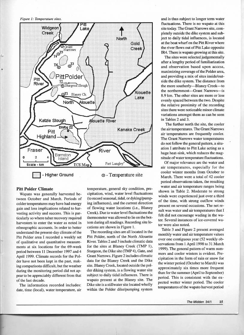
Figure 1: Temperature sites.
0 2
scale- km
FH- Higher Ground
Pitt Polder Climate Wapato was generally harvested be
tween October and March. Periods of colder temperatures may have had energy gain and loss implications related to harvesting activity and success. This is particularly so where tuber recovery required harvesters to enter the water as noted in ethnographic accounts. In order to better understand the present-day climate of the Pitt Polder area I recorded a weekly set of qualitative and quantitative measurements at six locations for the 69-week period between 11 December 1997 and 4 April 1999. Climate records for the Polder have not been kept in the past, making comparisons difficult, but the weather during the monitoring period did not appear to be appreciably different from that of the last decade.
The information recorded includes: date, time (local), water temperature, air
0 - Temperature site
temperature, general sky condition, precipitation, wind, water level fluctuations (to record seasonal, tidal, or dyking/pumping influences), and the current direction of flowing water locations (i.e., Blaney Creek). Due to water level fluctuations the thermometer was allowed to lie on the bottom during all readings. Recording site locations are shown in Figure 1.
The recording sites are all located in the Pitt Polder, north of the North Alouette River. Tables 2 and 3 include climatic data for the sites at Blaney Creek (TMP 1), Stwgeon, the Dike site (TMP 4), Gate, and Grant Narrows. Figure 2 includes climatic data for the Blaney Creek and the Dike site. Blaney Creek, located outside the polder diking system, is a flowing water site subject to daily tidal influences. There is wapato present at the Blaney site. The Dike site is a stillwater site located wholly within the Polder dike/pumping system
and is thus subject to longer term water fluctuations. There is no wapato at this site today. The Grant Narrows site, completely outside the dike system and subject to daily tidal influences, is located at the boat wharf on the Pitt River where the river flows out of Pitt L~e opposite IR4. There is wapato growing at this site.
The sites were selected judgementally after a lengthy period of familiarization and observation based upon access, maximizing coverage of the Polder area, and providing a mix of sites inside/outside the dike system. The distance from the more southerly-Blaney Creek-to the northernmost-Grant Narrows-is 8.9 km. The other sites are more or less evenly spaced between the two. Despite the relative proximity of the recording sites there were noticeable minor climate variations amongst them as can be seen in Tables 2 arid 3.
The further north the site, the cooler the air temperatures. The Grant N~ows air temperatures are frequently cooler. The Grant Narrows water temperatures do not follow the general pattern, a situation I attribute to Pitt Lake acting as a huge heat-sink, which reduces the magnitude of water temperature fluctuations.
Of major relevance are the water and air temperatures, especially for the cooler winter months from October to March. There were a total of 42 cooler period observations taken, the resulting water and air temperature ranges being
shown in Table 2. Moderate to strong winds were experienced just over a third of the time, with strong outflow winds present on several occasions. The net result was water and air temperatures that I felt did not encourage wading in the water. Several instances of ice-covered water were also noted.
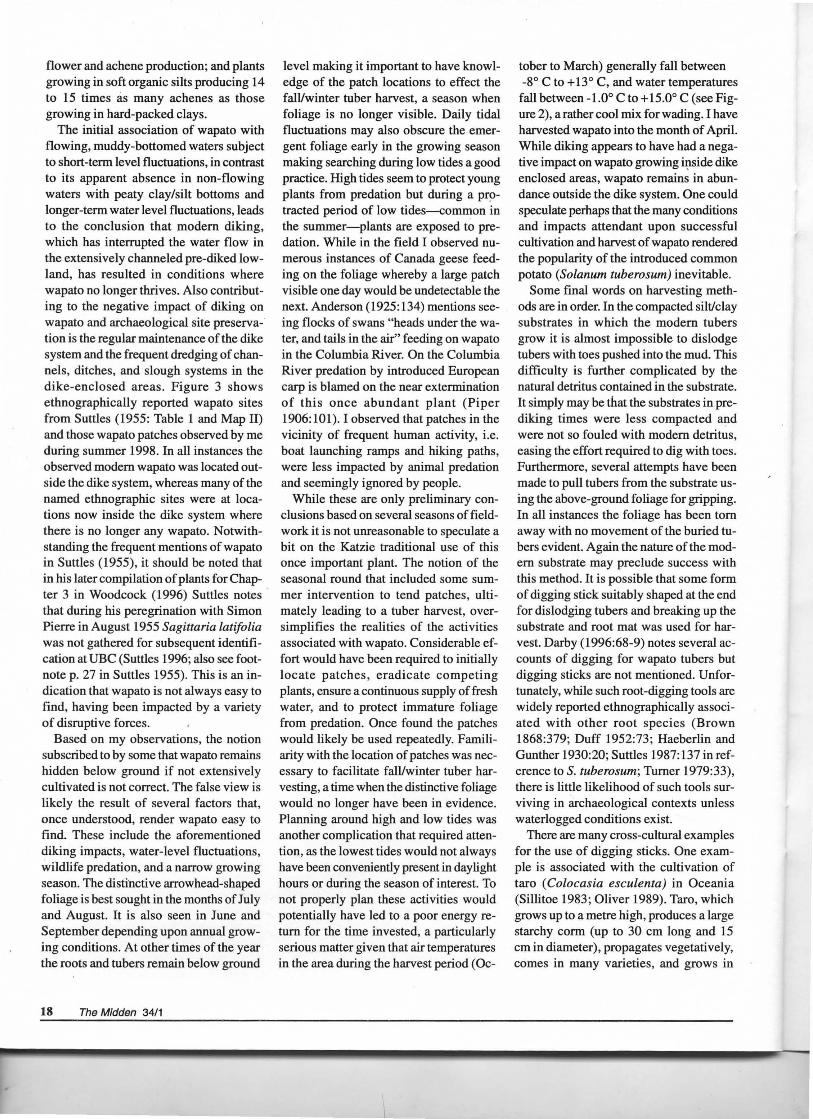
Table 3 and Figure 2 present averaged monthly water and air temperature values over one contiguous year (52 weekly observations from 1 April1998 to 31 March 1999). The general pattern of warm summers and cooler winters is evident. Precipitation in the form of rain or snow for the winter period (October to March) was approximately six times more frequent than for the summer (April to September) period. This is consistent with the expected wetter winter period. The cooler temperatures of the wapato harvest period
The Midden 34/1 15
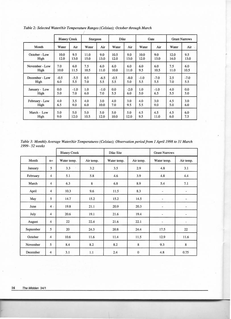
Table 2: Selected Water/Air Temperature Ranges (Celsius); October through March I
Blaney Creek Sturgeon Dike Gate Grant Narrows
Month Water Air Water Air Water Air Water Air Water Air
October - Low 10.0 9.5 11.0 9.0 10.5 9.0 10.0 9.0 12.0 9.5 High 12.0 13.0 15.0 13.0 12.0 13.0 12.0 13.0 14.0 13.0
November - Low 7.0 6.0 7.5 6.0 6.0 6.0 6.0 6.0 7.5 6.0 High 10.0 11.5 10.5 11.0 10.0 11.0 9.5 10.5 11.0 10.5
December - Low -0.5 -5.5 0.5 -6.5 -0.5 -8.0 -1.0 -7.0 2.5 -7.0 High 6.0 5.5 7.0 5.5 5.5 5.0 5.5 5.5 7.0 5.5
January - Low 0.0 -1.0 1.0 -1.0 0.0 -2.0 1.0 -1.0 4.0 0.0 High 5.0 7.0 6.0 7.0 5.5 6.0 5.0 6.5 5.5 5.0
February - Low 4 .0 3.5 4.0 3.0 4.0 3.0 4.0 3.0 4.5 3.0 High 6.5 9.0 6.0 10.0 7.0 9.5 5.5 9.0 5.0 6.0
March- Low 5.0 5.0 5.0 5.0 5.0 5.0 4.5 4.5 45 6.0 High 9.0 12.0 10.5 12.0 10.0 12.0 9.5 11.0 6.0 7.5
Table 3: Monthly Average Water/Air Temperatures (Celsius); Observation period from 1 April1998 to 31 March 1999-52 weeks
Blaney Creek Dike Site Grant Narrows
Month n= Water temp. Air temp. Water temp. Air temp. Water temp. Air temp.
January 5 3.3 3.2 3.5 2.9 4.8 3.1
February 4 5.1 5.8 4.6 3.9 4.8 4.4
March 4 6.3 8 6.8 8.9 5.4 7.1
April 4 10.3 9.6 11.5 8.3 - -
May 5 14.7 15.2 15.2 14.5 - -
June 4 · 19.8 21.1 20.9 20.3 - -
July 4 20.6 19.1 21.6 19.4 - -
August 4 22 22.4 21.6 22.1 - -
September 5 20 24.3 20.8 24.4 17.5 22
October 4 10.6 11.6 11.4 ll.5 12.9 11.6
November 5 8.4 8.2 8.2 8 9.3 8
December 4 3.1 1.1 2.4 0 4.8 0.75
16 The Midden 34/1
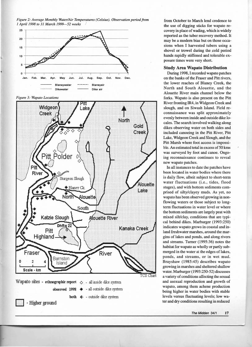
Figure 2: Average Monthly Water/Air Temperatures (Celsius). Observation period from 1 April1998 to 31 March 1999- 52 weeks I
Jan. Feb. Mar. Apr. May Jun. Jul. Aug. Sep. Oct. Nov. Dec.
Blaneywater Blaneyair
Dlkewater Dike air
Figure 3: Wapato Locations
0 2
Scale- km
::::::f···:::::: ............ . ..... ... .. ..... . .. .. ........ ..... . ..... ... ... ... ........ ...... . . . . . . . . . . . . . . ... .. ......... ..............
~~ Nottrf ...............
..... .......... .... ...........
····· ········· · ..... ..........
Wapato sites - etlmographic report ¢- - all inside dike system
obseiVed 1998 • - all outside dike system
L H -Higher ground both ~ - outside dike system
from October to March lend credence to the use of digging sticks for wapato recovery in place of wading, which is widely reported as the tuber recovery method. It may be a modem bias but on those occasions when I harvested tubers using a shovel or trowel during the .cold period hands rapidly stiffened and tolerable exposure times were very short.
Study Area Wapato Distribution During 1998, I recorded wapato patches
on the banks of the Fraser and Pitt rivers, the lower reaches of Blaney Creek, the North and South Alouette, and the Alouette River main channel below the forks. Wapato is also present on the Pitt River fronting IR4, in Widgeon Creek and slough, and on Siwash Island. Field reconnaissance was split approximately evenly between inside and outside dike locales. The search involved walking along dikes observing water on both sides and included canoeing in the Pitt River, ·Pitt Lake, Widgeon Creek and Slough, and the Pitt Marsh where foot access is impossible. An estimated total in excess of 50 kms was surveyed by foot and canoe. Ongoing reconnaissance continues to reveal new wapato patches.
In all instances to date the patches have been located in water bodies where there is daily flow, albeit subject to short-term water fluctuations (i.e., tides, flood stages), and with bottom sediments comprised of silty/clayey muds. As yet, no wapato has been observed growing in nonflowing waters or those subject to longterm fluctuations in water level or where the bottom sediments are largely peat with mixed silt/clay, conditions that are typical behind dikes. Marburger (1993:250) indicates wapato grows in coastal and inland freshwater marshes, around the margins of lakes and ponds, and along rivers and streams. Turner (1995:36) notes the habitat for wapato as wholly or partly submerged in the water at the edges of lakes, ponds, and streams, or in wet mud. Brayshaw (1985:45) describes wapato growing in marshes and sheltered shallow water. Marburger (1993:250-52) discusses a variety of conditions affecting the sexual and asexual reproduction and growth of wapato, among them achene production being higher in water bodies with stable levels versus fluctuating levels; low water and dry conditions resulting in reduced
The Midden 34/1 17
flower and achene production; and plants growing in soft organic silts producing 14 to 15 times as many achenes as those growing in hard-packed clays.
The initial association of wapato with flowing, muddy-bottomed waters subject to short-term level fluctuations, in contrast to its apparent absence in non-flowing waters with peaty clay/silt bottoms and longer-term water level fluctuations, leads to the conclusion that modem diking, which has interrupted the water flow in the extensively channeled pre-diked lowland, has resulted in conditions where wapato no longer thrives. Also contributing to the negative impact of diking on wapato and archaeological site preservation is the regular maintenance of the dike system and the frequent dredging of channels, ditches, and slough systems in the dike-enclosed areas. Figure 3 shows ethnographically reported wapato sites from Suttles (1955: Table 1 and Map II) and those wapato patches observed by me during summer 1998. In all instances the observed modem wapato was located outside the dike system, whereas many of the named ethnographic sites were at locations now inside the dike system where there is no longer any wapato. Notwithstanding the frequent mentions of wapato in Suttles (1955), it should be noted that in his later compilation of plants for Chapter 3 in Woodcock (1996) Suttles notes that during his peregrination with Simon Pierre in August 1955 Sagittaria latifolia was not gathered for subsequent identification at UBC (Suttles 1996; also see footnote p. 27 in Suttles 1955). This is an indication that wapato is not always easy to find, having been impacted by a variety of disruptive forces.
Based on my observations, the notion subscribed to by some that wapato remains hidden below ground if not extensively cultivated is not correct. The false view is likely the result of several factors that, once understood, render wapato easy to find. These include the aforementioned diking impacts, water-level fluctuations, wildlife predation, and a narrow growing season. The distinctive arrowhead-shaped foliage is best sought in the months of July and August. It is also seen in June and September depending upon annual growing conditions. At other times of the year the roots and tubers remain below ground
18 The Midden 34/1
level making it important to have knowledge of the patch locations to effect the fall/winter tuber harvest, a season when foliage is no longer visible. Daily tidal fluctuations may also obscure the emergent foliage early in the growing season making searching during low tides a good practice. High tides seem to protect young plants from predation but during a pr!Jtracted period of low tides--common in the summer-plants are exposed to predation. While in the field I observed numerous instances of Canada geese feeding on the foliage whereby a large patch visible one day would be undetectable the next. Anderson (1925: 134) mentions seeing flocks of swans "heads under the water, and tails in the air" feeding on wapato in the Columbia River. On the Columbia River predation by introduced European carp is blamed on the near extermination of this once abundant plant (Piper 1906: 101 ). I observed that patches in the vicinity of frequent human activity, i.e. boat launching ramps and hiking paths, were less impacted by animal predation and seemingly ignored by people.
While these are only preliminary conclusions based on several seasons of fieldwork it is not unreasonable to speculate a bit on the Katzie traditional use of this once important plant. The notion of the seasonal round that included some summer intervention to tend patches, ultimately leading to a tuber harvest, oversimplifies the realities of the activities associated with wapato. Considerable effort would have been required to initially locate patches, eradicate competing plants, ensure a continuous supply of fresh water, and to protect immature foliage from predation. Once found the patches would likely be used repeatedly. Familiarity with the location of patches was necessary to facilitate fall/winter tuber harvesting, a time when the distinctive foliage would no longer have been in evidence. Planning around high and low tides was another complication that required attention, as the lowest tides would not always have been conveniently present in daylight hours or during the season of interest. To not properly plan these activities would potentially have led to a poor energy return for the time invested, a particularly serious matter given that air temperatures in the area during the harvest period (Oc-
tober to March) generally fall between -8° C to+ 13° C, and water temperatures
fall between -1.0° C to+ 15.0° C (see Figure 2), a rather cool mix for wading. I have harvested wapato into the month of April. While diking appears to have had a negative impact on wapato growing iJ;tside dike enclosed areas, wapato remains in abundance outside the dike system. One could speculate perhaps that the many conditions and impacts attendant upon successful cultivation and harvest of wapato rendered the popularity of the introduced common potato (Solanum tuberosum) inevitable.
Some final words on harvesting methods are in order. In the compacted silt/clay substrates in which the modem tubers grow it is almost impossible to dislodge tubers with toes pushed into the mud This difficulty is further complicated by the natural detritus contained in the substrate. It simply may be that the substrates in prediking times were less compacted and were not so fouled with modem detritus, easing the effort required to dig with toes. Furthermore, several attempts have been made to pull tubers from the substrate using the above-ground foliage for gripping. In all instances the foliage has been tom away with no movement of the buried tubers evident. Again the nature of the modem substrate may preclude success with this method. It is possible that some form of digging stick suitably shaped at the end for dislodging tubers and breaking up the substrate and root mat was used for harvest. Darby (1996:68-9) notes several accounts of digging for wapato tubers but digging sticks are not mentioned. Unfortunately, while such root-digging tools are widely reported ethnographically associated with other root species (Brown 1868:379; Duff 1952:73; Haeberlin and Gunther 1930:20; Suttles 1987:137 in reference to S. tuberosum; Turner 1979:33), there is little likelihood of such tools surviving in archaeological contexts unless waterlogged conditions exist.
There are many cross-cultural examples for the use of digging sticks. One example is associated with the cultivation of taro (Colocasia esculenta) in Oceania (Sillitoe 1983; Oliver 1989). Taro, which grows up to a metre high, produces a large starchy corm (up to 30 em long and 15 em in diameter), propagates vegetatively, comes in many varieties, and grows in
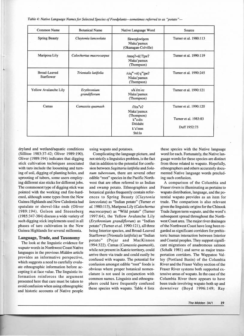
Table 4: Native Language Names for Selected Species of Foodplants-sometimes referred to as "potato"-
· Common Name Botanical Name Native Language Word
Spring Beauty Claytonia lanceolata SkweQkwinem Nlaka'pamux
(Okanagan-Colville)
Mariposa Lily Caloclwrtus macrocarpus /m5q?=u[·?]pe? Nlak:a'pamux (Thompson)
Broad-Leaved Trientalis latifolia /ciqw·=o[·qw]pe? Starflower Nlak:a'pamux
(Thompson)
Yellow Avalanche Lily Erythronium s!k:'em'ec grandijlorum Nlaka'pamux
(Thompson)
Camas Camassia quamash nftxwe?
dryland and wetland/aquatic conditions (Sillitoe 1983:37-42; Oliver 1989:190). Oliver (1989:194) indicates that digging stick cultivation techniques associated with taro include the loosening and turning of soil, digging of planting holes, and uprooting of tubers, some users employing different size sticks for different jobs. The commonest type of digging stick was pointed with the working end fire-hardened, although some types from the New Guinea Highlands and New Caledonia had spatulate or shovel-like ends (Oliver 1989: 194). Golson and Steens berg (1985:347-384) discuss fl. wide variety of such digging stick implements used in all phases of taro cultivation in the New Guinea Highlands for several millennia.
Language, Trade, and Taxonomy The look at the linguistic evidence for
wapato words in Northwest Coast Native languages in the previous Midden article provides an informative perspective, which suggests a need to carefully evaluate ethnographic information before accepting it at face value. The linguistic information reinforces the argument presented here that care must be taken to avoid confusion when using ethnographic and historic accounts of Native people
Nlaka'pamux (Thompson)
kwa.dis
Ditidaht k'a'm5s St6:lo
using wapato and potatoes. Complicating the language picture, and
not strictly a linguistics problem, is the fact that in addition to the potential for confusion between Sagittaria latifolia and Solanum tuberosum, there are several other edible "root" species in the Pacific Northwest that are often referred to as Indian and swamp potato. Ethnographies and botanical guides frequently contain references to Spring Beauty (Claytonia lanceolata) as "Indian potato" (Turner et al. 1980: 113), Mariposa Lily (Calochortus macrocarpus) as "Wild potato" (Turner 1997:64), the Yellow Avalanche Lily (Erythronium grandiflorum) as "Indian potato" (Turner et al. 1990: 121), all three being Interior species, and Broad-Leaved Starflower (Trientalis Latifolia) as "Indian potato" (Pojar and MacKinnon 1994:322). Camas (Camassia quamash), while not present in Katzie territory, could arrive there via trade and could easily be confused with wapato. The potential for confusion amongst edible "root" foods is obvious where proper botanical nomenclature is not used in conjunction with common names. Linguists and ethnographers could have frequently confused these species with wapato. Table 4 lists
Source
Turner et al. 1980:113
Turner et al. 1990: 119
Turner et al. 1990:245
Turner et al. 1990:121
Turner et al. 1990:120
Turneret al. 1983:83
Duff 1952:73
these species with the Native language word for each. Fortunately, the Native language words for these species are distinct from those related to wapato. Hopefully, ethnographers and others accurately documented Native language words precluding such confusion.
A comparison of the Columbia and Fraser rivers is illuminating as pertains to wapato distribution, language, and the potential wapato provides as an item for trade. The comparison is also relevant given the linguistic origins for the Chinook Trade Jargon term wapato, and the word's subsequent spread throughout the Northwest Coast area. The major river drainages of the Northwest Coast have long been regarded as significant corridors for prehistoric human interaction between Interior and Coastal peoples. They support significant migrations of anadromous salmon (Schalk 1981) and serve as major transportation corridors. The Wappatoo Valley (Portland Basin) of the Columbia River and the Fraser Valley section of the Fraser River systems both supported extensive areas of wapato. In the case of the Columbia River there appears to have been trade involving wapato both up and downriver (Boyd 1996:149; Ray
The Midden 34/1 19
1938:120; Ruby and Brown 1976:99).
Darby's (1996) wapato research is centred on this ·region. A similar upriver/ downriver movement of wapato is re
ported for the Fraser River, especially focused on the wapato patches in Katzie territory.
Summary The need to critically review historic
and ethnological data is evident. For wapato the modem records provide much
of value but the inherent biases must be identified and accounted for. The histori
cal context of the times, when changes were occurring in the use of wapato dur
ing the nineteenth century, is vital to its understanding. Critical review and con
textual analysis reveal much about wapato
and alert the modem researcher to the many sources of bias present in past records and to the potential for bias to
enter into the research undertaken here. A look at the modem Pitt Polder cli
mate in conjunction with contextual analy
sis of the historic changes that have affected the Polder since European contact provides an illuminating view of wapato
and the impacts affecting its continuing
exploitation by Native people. The climate conditions during the wapato harvest period in conjunction with indirect ethnographic evidence and cross-cultural data
support the argument that digging sticks were likely used to dig the tubers. A ma
jor influence has been diking, which appears to have affected wapato distribution such that it is no longer present in many
ethnographically reported locations.
Wapato is present today only in waters outside the dike system.
Wapato is not the only species to have been impacted by modem iilfluences. Locally, the Katzie were placed onto reserves
and this act in conjunction with land alienation effectively removed them from
the Pitt Polder lowland area. Traditional
uses of the landscape were truncated or ended altogether. The depredations of disease further reduced the number of Na
tive people able to eke out traditional sub
sistence. The introduction of new economic influences in combination with the other major changes effectively
brought about an end to the majority of traditional land uses in the area.
Analysis of Native language words for
wapato provides a tantalizing look at the
20 The Midden 34/1
use of wapato and possible trade implica
tions. Native wapato trade was eventually
ended through the introduction of the potato (Solanum tuberosum), a factor that
has many implications involving wapato
use. The introduced potato had economic, trade, and horticultural implications. Taxonomic nomenclature can at the same
time confuse and clarify the wapato picture. Ultimately, the widespread use of the terms "wapato" and "potato" to refer to a
variety of edible root species requires researchers to be alert to potential confusion in historic and ethnographic data
sources.
Selected References For a complete list of references refer to: Spurgeon, T. 2001 Wapato (Sagittaria latifolia) in Katzie Traditional Territory, Pitt Meadows, British Columbia. Unpublished MA thesis, Department of Archaeology, Simon Fraser University, Burnaby, BC; for additional references see also The Midden 33/4.
Anderson, James R. 1925 Trees and Shrubs: Food, Medicinal and Poisonous Plants of British Columbia. Department of Education, Victoria.
Boyd, Robert, 1996 People ofThe Dalles: The Indians ofWascopam Mission. University of Nebraska Press, Lincoln.
Brayshaw, ChristopherT. 1985 Pondweeds and Bur-reeds, and Their Relatives, of British Columbia British Columbia Provincial Museum No. 26 Occasional Papers, Victoria.
Collins, J.E. 1975 The Reclamation of Pitt Meadows. MA Thesis, Department of History, Simon Fraser University, Burnaby.
Duff, Wilson 1952 The Upper Stalo Indians. Anthropology In British Columbia Memoir No. I , British Columbia Museum, Victoria.
Glavin, Terry 2000 The lAst Great Sea: A Voyage through the Human and Natural History of the North Pacific Ocean. Greystone Books, a division of Douglas & Mcintyre, Vancouver, BC.
Golson, J., and A. Steensberg 1985 The Tools of Agricultural Intensification in the New Guinea Highlands. Prehistoric Intensive Agriculture in the Tropics, Part 1, edited by I.S. Farrington, pp.347-382. BAR International Series 232, Oxford.
Hammersley, M., and R. Gomm 1997 Bias In Social Research. Sociological Research Online , 2(1) . At <http:// www.socresonline.org. uk/socresonline/211/ 2.html>, (accessed 07/17/98).
Harris, R. Cole 1997 The resettlement of British Columbia: essays on colonialism and geographical change. University of British Columbia Press, Vancouver.
Hodder, Ian 1991 Reading The Past: Current Approaches to Interpretation in Archaeology. Second edition, Cambridge University Press, Cambridge.
Horton, Douglas 1987 Potatoes: Production, Marketing and Programs for Developing Countries. Westview Press, Boulder.
Jenness, Diamond 1955 The Faith·of A Coast Salish Indian. Anthropology in British Columbia Memoirs Nos. 1 & 2. British Columbia Provincial Museum, Victoria.
Lepofsky, Dana 2002 Paleoethnobotany in the Northwest. People and Plants in Ancient North America, edited by P. Minnis , Smithsonian Institution Press, in press.
Loewen, Dawn Christy 1998 Ecological, Ethnobotanical, and Nutritional Aspects of Yellow Glacier Lily, Erythronium grandiflorum Pursh (Liliaceae), in Western Canada Master of Science thesis, Department of Biology, University of Victoria, Victoria.
Lyons, Natasha 2000 Investigating Ancient Socioeconomy. in St6:lo Territory: a Palaeoethnobotanical Analysis of the Scowlitz Site, Southwestern BC. MA thesis, Department of Archaeology, Simon Fraser University, Burnaby.
Macintosh, Winnifreda (transcriber) 1963 Fort Langley Journal June 27, 1827- July 30, 1830. Transcription attributed to James MacMillan and Archibald McDonald. Provincial Archives of British Columbia, Victoria.
Maclachlan, Morag, ed. 1998 The Fort Langley Journals 1817-30. UBC Press, Vancouver.
McKelvie, B.A. 1947 Fort Langley, Outpost of Empire. Vancouver Daily Province, Vancouver.
---1991 Fort Langley, Birthplace of British Columbia. Porcepic Books, Victoria.
Murphy, Paul1929 The History of Fort Langley. Unpublished thesis, University of British Columbia pp.18-20. Manuscript held by the Archives of British Columbia, Victoria.
Norton, H.H., E.S. Hunn, C.S. Martinsen, and P.B. Keely 1984 Vegetable Food Products of the Foraging Economies of the Pacific Northwest.Ecology of Food and Nutrition, 14:219-228.
Oliver, Douglas L. 1989 Oceanic: The Native Cultures of Australia and the Pacific Islands. Volume 1, University of Hawaii Press, Honolulu.
Piper, Charles 1906 Flora of the State of Washington. Smithsonian Institution, United States National Museum, Contributions from the United States National Herbarium, 11:1-637. Government Printing Office, Washington.
Pojar, Jim, and Andy Mackinnon 1994 Plants of Coastal British Columbia including Washington, Oregon and Alaska. BC Ministry of
Forests and Lonepine Publishing, Vancouver. Ray, Verne F. 1938 Lower Chinook Ethno
graphic Notes. University of Washington Press, Seattle.
Rivera, Trinita 1949 Diet of A Food-Gathering People, With Chemical Analysis of Salmon and Saskatoons. Indians of the Urban Northwest, edited by Marian W. Smith, pp 19-36. 1969 reprint, AMS Press, New York.
Ruby, Robert H. and John A. Brown 1976 The Chinook Indians: Traders of the Lower Columbia River. University of Oklahoma Press, Norman.
Schalk, Randall F. 1981 ''The Structure of an Anadromous Fish Resource," in Advances In Archaeological Method and Theory, edited by Michael Schiffer, 4:207-249.
Sillitoe, Paull983 Roots of the Earth, Crops in Highland Papua New Guinea. Manchester University Press, Manchester.
Suttles, Wayne 1996 "Katzie Ethnobotanical Notes." Chapter 3 in Katzie Natural Resources Past and Present: A Report on the History of the Natural Resources Within the Traditional Te"itories of the Katzie People, edited by Waneta Woodcock, pp 44-57. Katzie Band Office, Pitt Meadows.
---1998 Names in the Fort Langley Journals. In The Fort Langley Journals 1827-30, edited by Morag Maclachlan, Appendix E, pp 233-238. UBC Press, Vancouver.
Trigger, Bruce G. 1989 A History of Archaeological Thought. Cambridge University Press, Cambridge.
Turner, Nancy J. 1979 Plants in British Columbia Indian Technology. Handbook No. 3.8. British Columbia Provincial Museum, Victoria.
---1995 Food Plants of Coastal First Peoples, Royal British Columbia Museum Handbook. UBC Press, Vancouver.
Turner, Nancy J ., Randy Bouchard, and Dorothy I.D. Kennedy 1980 Ethnobotany of the Okanagan-Colville Indians of British Columbia. Occasional Papers of the British Columbia Provincial Museum, No. 21, Victoria.
Turner, Nancy J., John Thomas, Barry F. Carlson, and Robert T. Ogilvie 1983 Ethnobotany of the Nitinaht Indians of Vancouver Island. British Columbia Provincial Museum, No. 24 Occasional Papers Series, Victoria.
Woodcock, Waneta 1996 Katzie Natural Resources Past and Present: A Report on the History of the Natural Resources Within the Traditional T~"itories of the Katzie People. Katzie Band Office, Pitt Meadows.
FIELD NOTES TRACES ARCHAEOLOGICAL RESEARCH & CONSULTING LTD.
TRACES Archaeological Research & Consulting Ltd. had a busy year in 2001 investigating and recording 170 cultural heritage sites in the Vanderhoof Forest District (VFD) under permit 2001-171. A total of 46 development areas were surveyed, and cultural heritage resources were identified in all but three of these developments.
Developments investigated include large areas along trail routes, lakeshores, and drainage systems surveyed for Mountain Pine Beetle (MPB) salvage operations, as well as small MPB broods, logging blocks, and a forestry recreation site. TRACES conducted 39 AlAs (archaeological impact assessment), seven PFRs (preliminary field reconnaissance), as well as an AlA, test excavations, and subsequent monitoring at site GaSe 10. The latter project was in response to a proposal to relocate four outhouses within a forestry recreation site. A large portion of the archaeological site GaSe 10 is located within the recreation site area.
TRACES employed representatives from the Cheslatta Carrier Nation, Lhooskuz Dene Government, Nazko Band Government, Saik' uz First Nation, Ulkatcho Indian Band, and N adleh Whut'en Band during these assessments. Many of our representatives had considerable archaeological survey experience with either TRACES, or other archaeological consulting companies.
Of the 170 sites investigated by TRACES in 2001, 14 were previously recorded archaeological sites which were revisited for verification of locations, as well as additional recording and mapping. One hundred and nine of the sites identified and revisited by TRACES in 2001 were protected sites and include cultural material (subsurface and surface), cultural depressions (cache pits, a roasting pit, and house pits), pre-1846 CMT sites, heritage trails, message trees, and an arborgraph of a human face. Sixty-one non-protected sites were recorded, the majority of which
were post-1846 CMT sites, as well as trails, a trap house, a historic cabin, and two above-ground caches . .
The archaeological sites identified and recorded by TRACES in 2001 ranged in size from isolated lithic scatters and CMTs, to small village sites with up to 56 cultural depressions, large-scale cambium harvest CMT sites, and large expanses of heritage trails. Many of the survey areas investigated by TRACES in 2001 were situated along major trail corridors within the VFD including the Messue, Mill's Creek, and Cutoff Creek trail routes. The trails proved to be rich in cultural heritage sites from the pre-contact period into the historic pefiod, confirming that Aboriginal trails should be heavily considered when predicting areas of high and moderate archaeological site potential (Carlson 1996).
-NICOLE JACKMAN-CRAIG
DEBITAGE Coming this autumn to the Society for American Archaeology's Web site <www.saa.org> is a peer-reviewed serial in a digital format. It will be available on-line free of charge. The publication will provide context for scholarly contributions to archaeology that cannot be produced in traditional hardcopy media. If you are interested in creating a submission for this new digital publication, contact editor John Hoopers at the Department of Anthropology, University of Kansas, 785.864.2638 or email <[email protected]>.
Individuals interested in looking for archaeological fieldwork opportunities can now submit their c. v. to the Canadian Archaeological Association's (CAA) Fieldwork Resume Database. Your resume stays in the database, and CAA members can search the database for field workers in the CAA Webmember's Section. The Fieldwork Resume Database is located at <www.canadianarchaeology.com/ home.lasso>.
The Midden 34/1 21
Top Related