


Languages
Pages
Legal


A Course Syllabus
on
BE in Geomatics Engineering
Kathmandu University (KU) in collaboration with
Land Management Training Center (LMTC)
Prepared By
Department of Geomatics Engineering
Kathmandu University
Dhulikhel, Kavre

Year I
Semester I
CHEM 101: General Chemistry, 3 credits
Objective: The objective of this course includes the knowledge of mole concept, properties of solutions, chemical equilibria,ionicequilibria in aqueous solutions, oxidation-reduction reactions, chemical thermodynamics and kinetics.
Pre-requisite: N/A
Detailed Course Outline: 1. Properties of solution – phase equilibria, energetic of phase change,
liquid-vapour equilibrium, the equilibrium state; temperature dependence of vapour pressure, types of solutions, concentration units, the ideal solution; boiling and freezing points of solutions, solutions of two volatile components, non-ideal solutions; osmosis, solubility & effects of temperature on solubility.
2. Chemical equilibrium – Introduction, the nature of chemical equilibrium, equilibrium constant and related calculations, external effects on equilibria.
3. Ionic equilibria in aqueous solutions – sparingly soluble salts, selective precipitation; acids and bases and their concepts, strength of acid or base, pH scale, self ionization of water, weak acids and bases; hydrolysis, buffer solutions, indicators, acid-base titrations.

4. Oxidation-reduction reactions – oxidation states, the half-reaction concept, balancing redox reactions, galvanic cells, Nernst equation, electrolysis and electrochemical applications.
5. Chemical thermodynamics – Introduction, system, state and state function, work and heat, first law of thermodynamics, thermochemistry, criteria for spontaneous change, entropy and the second law of thermodynamics, molecular interpretation of entropy, absolute entropies and the third law; free energy, criteria of equilibrium, equilibrium constant, electrochemical cells, temperature dependence of equilibria.
6. Chemical kinetics – Introduction, concentration effect, differential and integral rate laws, experimental determination of rate laws, order and molecularity, reaction mechanisms, elementary processes, mechanism and rate laws, reaction rates and equilibria, steady state approximation, chain reactions, reaction rate and equilibria, collision theory of gaseous reactions, temperature effect on reaction rate; rates of reactions in solutions, problems; catalysis (homogeneous, heterogeneous and enzyme catalysis).
References: Mahan, B.H. University Chemistry, 3rd Edition, Narosa Publ. House, India.
EDRG 101: Engineering Drawing I, 2 Credits
Objective:The course provides first year students with technical drawing skills for applications in engineering, environmental and physical sciences. It includes the knowledge of technical writing, scale and geometrical construction, along with knowledge of AutoCAD
Pre-requisite:N/A
Detailed Course Outline: 1. Introduction to Engineering Drawing and Lettering (Introduction to
Engineering Drawing and Instruments used in Engineering Drawing, Layouts of Drawing Sheets, Types of lines, Lettering and its types) 4
2. Dimensioning and Scaling (Units of Dimensioning, System of Dimensioning, Engineering Scale, Construction and Types of Scales: Plain Scale, Diagonal Scale, Vernier Scale) 4
3. Geometrical construction, Conic Sections (Construction of regular polygons, Conic Section: Definition and Terminology, Application, Construction of Conic Sections) 4
4. Introduction to AutoCAD (AutoCAD software for the engineering graphics and its application, Description of the drawing screen and setting up drawing, Getting started with AutoCAD and initial setup commands) 4
5. Basic Commands of AutoCAD (Introduction to Draw toolbar and Modify toolbar4
6. Engineering Curves ( Hyperbola, Involute, Spiral, Cycloid) (Definition and Terminology, Application and Construction) 4
7. Orthographic Projections (Projection of an Object, Principal Views and Principal Planes of Projection, Systems of Projection and its symbols, Projection of points, Projection of lines) 4

8. Projection of Plane surface and Solids (Projection of Plane surfaces, Definition and Classification of Solids, Projection of solids) 4
9. Surface Development (Methods of Development: Parallel line development, Radial line development, Triangulation development, Approximate development) 4
10. Dimensioning on AutoCAD (Introduction and terminology, Dimension styles, Linear dimension, Aligned dimension, Angular dimension, Radius and Diameter dimension, Angular dimension, Base line dimension) 4
References:
1. “Engineering Drawing Vol. 1 & 2”, K.R Gopalkrishna 2. “A Textbook of Machine Drawing”, V. Laximinarayan, M.L. Mathur 3. “Engineering Drawing (Geometrical Drawing)”, P.S. Gill
ENGG 101: Engineering Project I, 2 Credits
Objective: This is a practical oriented course intended to provide knowledge and basic skills in planning, budgeting and implementing small project works in related fields of study (Environmental Science/Engineering). It involves the actual construction of a structure or device used in the field of study.
Pre-requisite:N/A.
ENGT 101: Communication Skill I, 2 Credits

Objective:The course is intended to provide basic college-level language skills for science and engineering students. It is designed to enhance their reading, comprehension, oratory and technical writing skills.
Pre-requisite:N/A.
Detailed Course Outline: 1. Reading and comprehension – Yudishthira’s wisdom; Why go to
university? The library card; A fight between a lion and . . .; Teaching in the television culture; The Cabuliwallah; The Savage male; Stopping by the woods.
2. Writing – Memos, minutes, letters, resumes, text review; question/answers. 3. Writing (others) – Journal writing; text review; presentation outlines. 4. Technical writing – Memos, minutes, letters, resumes, document design,
text reviews, and oral presentations. 5. Oral presentation – Extempore, seminar, other types of presentations. 6. Project work – Library work, study visits, proposal writing.
Prescribed Text Books: a. Gerson and Gerson. 2001. Technical Writing: Process and Product.
Pearson, India. b. Nissani, M. and Shreedhar, L. (Eds.) 1996. Adventures in English. Ekta
Books, Kathmandu, Nepal

MATH 101: Calculus and Linear Algebra, 3 credits
Objective: The aim of this course is to provide students with adequate mathematical skills to cope with a wide variety of problems in the fields of science and engineering. It offers explanations of the fundamental concepts and illustration of how they are applied in the various disciplines within the above mentioned fields.
Pre-requisite:N/A.
Detailed Course Outline: A. Calculus 1. Increments – average and instantaneous rates of change, slope of the curve
y = f(x); derivatives as instantaneous rates of change; velocity and other rates of change.
2. Limits and continuity – Properties of limits, one-sided limits, existence of limit at a given point, infinity as a limit, limits of exponential and logarithmic functions, types of discontinuities.
3. Differentiation – definition, polynomial functions and their derivatives; product, power, and quotient rules; implicit differentiation and fractional power; chain rule and parametric equations; angle between two curves; derivatives of trigonometric, hyperbolic and their inverse functions; derivatives of logarithmic and exponential functions and their applications; differentials.
4. Applicationsof derivatives – curve sketching, the sign of first derivatives; concavity and points of inflection, asymptotes and symmetry; maxima and minima, theory and problems, related rates; Rolle’s theorem, Mean value theorem; indeterminate forms, L’hospital’s rule.
5. Integration – introduction, indefinite integration; applications of determining constants of integration; integrals of trigonometric functions, examples of
product of powers of trigonometric functions; definite integrals, calculating areas as limits, fundamental theorem of integral calculus (statement and application); basic integration formulas, substitution method, integration by parts, improper integrals.
6. Application of definite integrals – area between curves; average value of a function; length of a plane curve; calculating volume by slicing; areas of surfaces of revolution.
B. Linear Algebra 1. Sequence and Infinite Series – sequence of numbers, limits that arise
frequently, infinite series, test for convergence of series with non-negative terms, absolute convergence, alternating series, conditional convergence.
2. Vector spaces – introduction, linear combinations, spans of vectors, linear dependence and independence, bases and their selection, dimension and rank.
3. Eigen values, Eigen vectors and Linear Mapping – characteristic equations, Eigen value and Eigen vectors, Linear transformation (up to R3) and its properties.
References: a. Thomas and Finney ( ) Calculus and Analytical Geometry, 9th Edition,
Narosa Publ. House, New Delhi. b. Brown, J.W. and Sherbert, D.R. ( ) Introductory Linear Algebra. Bindle,
Weber and Schmidt. c. Finkbeiner, D.T. ( ) Introduction to Matrices and Linear Transformations, 3rd
Edition, CBS Publisher and Distributors, Delhi. d. Shastry, S.S. ( ) Engineering Mathematics. Prentice Hall of India, New Delhi. e. Dass, H.K. (2008) Advanced Engineering Mathematics. S. Chand Publ., New
Delhi.

PHYS 101: General Physics I (2 credits)
Objective: The course is especially prepared for first-year undergraduate students of all branches of science and engineering to help them develop physical intuition through a comprehensive understanding of fundamental concepts emphasizing physics rather than complicated mathematical treatment. Contents include: dynamics of a system of particles, rotational dynamics, oscillatory motion, gravitation and gravitational potential; motion of a particle under central force field; angular momentum conservation, one body problems, two body problems, their reduction to one-body problem and their solution; elasticity, viscosity, interference, diffraction and polarization.
Pre-requisite:N/A.
Detailed Course Outline: 1. Dynamics of system of particles - Work done by constant and variable
forces, Work-energy theorem, conservative and non-conservative forces, force as negative gradient of potential energy, conservation of linear momentum, Center of mass, System of variable mass, particle collision: one dimensional and two dimensional.
2. Rotational Dynamics - Angular momentum of a single particle and system of particles, torque, Conservation of angular momentum, Rotation about fixed axis: K. E. of rotation, Moment of inertia and Radius of gyration, Theorem of parallel and perpendicular axes, calculation of rotational inertia for slender rod, circular disc and solid sphere.
3. Wave and Oscillation - Simple harmonic oscillator, Compound pendulum, loaded spring, Time average of energy, Damped harmonic oscillator, forced vibration and resonance in light damped system, reverberation of sound, Ultrasonics and Acoustics of Buildings, Sabines formula,

4. Motion of particle under central force field - Central force, Angular momentum conservation, one-body problem, two-body problem and its reduction to one body problem, Concept of reduced mass, nature of trajectories.
5. Elasticity- Stress, strain, elastic limit, Elastic and plastic behavior, Types of elasticity, Poisson’s, work done per unit volume in stretched wire, Relation between elastic constants (without derivation), bending of bar (without derivation), elastic hysteresis.
6. Viscosity - Stream line and turbulent flow, Continuity equation, Bernoulli’s principle, Coefficient of viscosity, Newton’s formula, Poiseuille’s equation for flow of liquid through a tube, Reynold’s number, viscostatic fluids for lubrication.
7. Optics – Interference - Monochromatic radiation, Coherent sources, Constructive and destructive interference, Young’s double-slit experiment, Intensity distribution, Interference in thin films due to reflected and transmitted light, Newton’s rings.
8. Diffraction- Rectilinear propagation of light, Distinction between Fresnel and Fraunhoffer diffraction, Diffraction at single and double slit, Diffraction grating, Achromatic doublet, Ramseiden eyepiece and Huygens eyepiece, resolving power of telescope and microscope.
9. Polarization- Polarization and transverse nature of light, Polaroid, Double refraction, Polarization by reflection, Brewster’s law, Malus’ law, Nicol prism as polarizer and analyzer, Optically active substances, Specific rotation, Polaroids.
10. Laser - Properties of laser radiation, the laser process, including stimulated and spontaneous emission and population inversion, optical and electrical pumping,. Gas and semiconductor lasers, Applications of lasers.
11. Heat and Thermodynamics - Heat transfer - Heat flux and thermal conductivity, convection and radiation (Wien’s displacement law, Rayleigh-Jean’a law, limitation of classical law), Plank’s law to explain black body radiation, Boltzman, Stafan’s law.
12. Thermodynamics - Thermodynamic system and thermodynamic variables, Equation of state of ideal gas, p-v diagram, First law of thermodynamics and applications, Conversion of heat into work and vice versa, Energy from fossil fuels.
13. Second law of thermodynamics - Heat engines, Refrigerators, Efficiency of ideal and practical heat engines, Statements, Kevin-Planck and Clausius statements, Entropy.
Experiments:
a. Determination of the value of ‘g’ by compound pendulum b. To determine the Young's modulus of the material of a rectangular bar
by the method of bending. c. To determine the coefficient of viscosity of water by capillary tube
method. d. Determination of thermal conductivity of a bad conductor by Lee’s method e. To determine the wavelength of sodium light by measuring the diameter
of Newton's rings. f. To determine the refractive index of sugar solution at different
concentrations using a spectrometer. g. To determine the wavelength of sodium light using a plane diffraction
grating. h. To determine the specific rotation of a given sample using Laurent's half-
shade polarimeter References 1. Physics part 1 and part 2 -R. Resnick& D. Halliday 2. Mechanics, Statistical Physics and Thermodynamics - A. J. Bahl, O. P.
Verma& R. D. Sharma 3. Laser Theory and Applications -A. Ghatak 4. Mechanics - J. K. Ghosh 5. Elements of Properties of Matter - D. S. Mathur
6. B. Sc. Practical Physics - C. L Arora 7. Physics for Engineers and Scientists
COMP 103: Structured Programming (2 Credit) Objective: This course introduces the fundamental concepts of procedural programming in C. Topics include data types, control structures, functions, arrays, etc. This course also focuses on the development of problem solving skills using programs. Pre-requisite:N/A.
Detail Course Outline 1. Introduction to Computer Systems
Brief history of computation, Architecture and Peripherals 2. Introduction to Software Systems
System Software, Application Software, Programming Languages 3. Introduction to Software Life Cycle
Problem solving and software engineering – a brief introduction (SDLC), Algorithms and Flowchart
4. Fundamentals of C The C Character Set, Identifiers and Keywords, Data Types, Variables, Constants, Declarations Statements
5. Operators and Expressions Introduction, Arithmetic Operators, Unary Operators, Relational and Logical Operators, Assignment Operators, Conditional Operators, Operator Precedence
6. Decision Control Statements Introduction, The if-else Construct, The nested if-else Construct, The else-if ladder Construct, The switch Construct
7. Loop Control Statements

Introduction, The while Construct, The do-while Construct, The for Construct
8. Functions Anatomy of a Function (Defining a function, accessing a function), Function Prototype, Recursion (Introduction and some programs)
9. Program Structure Storage Classes, Automatic, External and Static Variables
10. Arrays Introduction, Processing an Array, Passing Arrays to Functions, Multidimensional Array
11. Structures Understanding C’s Structures, Referencing a Structure Member, Using Structure with Function calls, Arrays of Structures, Understanding Unions
12. Pointers Introduction, Passing Pointers to Functions, Pointers and One Dimensional Array, Pointers to Structures, Dynamic Memory Allocation, Operations on Pointers
Reference Books: 1. Byron s. Gottfried, “Theory and Problems of Programming with C, 2/e”,
McGraw-Hill. 2. Robert L Wood, “C Programming for Scientists and Engineers”, Penton
Press. ENGG 111: Elements of Engineering I (3 credits)
Objective: This course will accommodate the civil engineering foundations in the existing
Basic Mechanical Engineering taking advantage of commonalities in the topics shared by
those courses Including Mechanics, Strength of Materials and Fluid Mechanics. The
topics covered by Basic Mechanical Engineering will be restructured and made into three
major topics instead of existing five topics. The additional topics will include the topics

in basic civil engineering will include building materials, components and structure; and
surveying.
Detail Course Outline
1. Engineering Mechanics and Strength of Materials [9 hr.]
Equivalent force systems: equilibrium, friction, cables, centre of gravity. Velocity,
acceleration, momentum, Newton’s second law of motion, the moment law, work and
energy, rotation about a fixed axis. Concepts of stress, strain, stress-strain diagram,
Hook's law.
2. Building Materials, Components and Structure Civil Engineering Materials: Bricks, stones, sand, cement, concrete, steel sections. Foundations: Types, bearing capacity.
Requirements of good foundations. Superstructure: Brick masonry, stone masonry,
beams, columns, lintels, roofing, flooring, plastering. Mechanics: Internal and external
forces. Types of Bridges and Dams. Basics of Interior Design and Landscaping.
3. Surveying Fundamental Definitions and Concepts, Chain Surveying, The compass leveling, Plane table
surveying, Theodolite, EDM & Total station, Contouring, GIS and remote sensing
4. Thermal Engineering and Thermal Power Plants Laws of thermodynamics, heat engines, gas power cycles – Otto, Diesel, Brayton, Rankine
cycles. Internal combustion engines. Vapour power cycles and thermal power plants.
Refrigeration and air conditioning.
5. Fluid Mechanics and Hydraulic Machineries
Introductory concepts, fluid properties, fluid in motion, types of flows, continuity equation,
mass conservation equation, Bernoulli’s equation, boundary layer. Turbo machines, types
of hydro turbines, axial flow and centrifugal flow machines. Pumps.
Year I

Semester II
PHYS 102: General Physics II, 3 credits
Objective: The course designed to give students the knowledge of electrical fields, electrostatic energy; magnetic flux, electromagnetic induction, dielectric and magnetic properties of matter, and electric circuits.
Pre-requisite:N/A.
Detailed Course Outline: A. ELECTRICITY AND MAGNETISM
1. The Electric Field and Electric Potential - Gauss’s law in electrostatic, application of Gauss’s law, electric field due to: spherical charge distribution, non-conducting sheet of charge & charged conductor Potential due to: a point charge, system of point charge, potential at appoint on the axis of a charged disc. Equi-potential surface, potential gradient Electric dipole, potential and electric field due to a short dipole, force and torque on a dipole, energy of a dipole in an electric field.
2. Electric Field in Material Medium - Dielectrics and Gauss’s theorem, three electric vectors; Electric field E, Electric displacement D & Polarization P, Energy stored in an electric field.
3. The Magnetic field- The Hall effect, Biot-Savart law and its application, magnetic field at point on the axis of a circular current loop, Ampere’s law, Applications of Ampere’s law, magnetic field due to: current in long straight conductor, a solenoid, force between two parallel conductors.
4. Electromagnetic Introduction - Faraday’s law of electromagnetic introduction, Lenz’s law, Motional EMF, time varying magnetic fields, induction and relative motion, Inductance, L circuit, Energy in magnetic field, mutual induction.

5. Magnetic properties of matter- Dia-magnetism, Para-magnetism and Ferro-magnetism, the three magnetic vectors; the magnetic field B, the magnetic field strength H and magnetization M.
6. Alternating currents and electromagnetic oscillations - Complex representation of AC, complex admittance and impedance, LCR series circuit, resonance in LCR series circuit, resonance in LCR parallel circuit, electromagnetic oscillations in (i) LC circuit and (ii) LCR circuit, forced oscillations and resonance: Induced magnetic field displacement current.
B. MODERN PHYSICS 7. A brief introduction to quantum mechanics- Blackbody radiation and
Planck's hypothesis, Photoelectric effect, the Compton effect, Photons and electromagnetic waves, The wave properties of particle, de Broglie wave, uncertainty principle.
8. Physics of atoms and molecules -Atomic spectra: visible and X-ray, Molecular bonds, molecular spectra, Band theory of solid electrical conduction in, Metals, Insulators and semiconductors, superconductivity.
9. Nuclear Structure - Nuclear binding energy, Natural and artificial radioactivity, Nuclear reactions, Nuclear magnetic resonance (NMR) & Magnetic resonance imaging (MRI)
10. Applications of Nuclear Physics - Nuclear fission and fusion, Nuclear reactors, radiation detectors, radiation hazards, Uses of nuclear radiation.
Reference books:
a. R. Resnik and B. Halliday, Physics Part II b. E. M. Purcell, Electricity and Magnetism c. J. R. Reitz, F. J. Milford, R. W. Christy, Foundations of
Electromagnetic Theory d. R. A. Serway, J. W. Jewett, Physics for Scientists and Engineers,
Vol II, THOMSON, BROOKS
ENGT 102: Communication Skill II (2 Credits)

Objective: The course builds upon the precursor (Communication Skill I) with increased complexity of language skills. The overall objective is to provide science and engineering students with the requisite skills for essay, report and proposal writing. Detailed Course Outline:
1. Reading skills – Where the mind is without fear; Keeping errors at bay; The telegram on the table; A Tale; How sane are we? Mr. Know-all; Who was to balme? We are breaking the silence about death (from Adventures in English).
2. Technical/Professional Writing: a. Research essay and technical articles – basics of research, using
primary data, fieldwork, interviews; using secondary data, books and internet; Documentation, APA style; Organization and format, general format, technical articles.
b. Proposal writing – What is a proposal? Types of proposals; Criteria for writing a proposal; general formats for internal and external proposals.
c. Report writing – What is a report? Long reports (project), progress reports, complete reports, memo reports; general formats and mechanics.
References:
a. Gerson and Gerson. 2001. Technical Writing: Process and Product. Pearson, India.
b. Nissani, M. and Shreedhar, L. (Eds.) 1996. Adventures in English. Ekta Books, Kathmandu, Nepal.

ENVE 101: Introduction to Environmental engineering, 2 credits Objective: The course is intended to provide students with a general background and introduction to the subject areas and scope of environmental engineering. The course covers the topics described below in a brief and general manner. Pre-requisite:N/A.
Detailed Course Outline:
1. Fundamentals of Ecology: Organization, functioning and development, Concept of ecosystem, Organization of ecosystem: abiotic and biotic component, Functioning of ecosystem: ecological energetic. Biogeochemical cycles- N2, H 20,So2,P: homeostasis, Concept of limiting factors, Habitat and niche, Ecological equivalents, Sympatry and Allopatry
2. Environmental Engineering: Introduction, Environmental system overview, Environmental ethics, A material balance approach to problem solving, Environmental law, Environmental Economics
3. Hydrology: The hydrological cycle, Surface water hydrology, Ground water hydrology, Common units of measurement, The hydrologic equation, Rainfall analysis, Runoff analysis
4. Water Quality management: Water pollutants and their sources, Water quality standard, Water Quality Analysis, Water treatments, Water Supply: Population estimation and Prediction, Consequence of overdrawing surface water and ground water, Water Pollution- Nepalese context, Arsenic pollution in Nepal
5. Wastewater treatment: Wastewater microbiology, Characteristics of waste water, Municipal waste water treatment system, Reed Bed Waste water treatment system

6. Air pollution: Physical and chemicals fundamentals, Air pollution perspectives, Air pollution standards, Effect of air pollution, Air pollution meteorology, Atmospheric dispersion, Indoor air pollution, Control measures, PM 10 – An analysis of Brick Kilns factory
7. Noise pollution: Introduction, Effect of noise on people, Rating system, Noise control
8. Solid waste management: Introduction, Sources, collection, transportation, landfilling, incineration and composting, Resource conservation and recovery, Hazardous wastes
9. Global environmental events: Global warming, Ozone layer depletion, Acid deposition, Eutrophication, Asian Brown Cloud, Case study: Chernobyl disasters, Bhopal gas tragedy and Minamatta disease
10. Environmental mathematical modeling 11. Environmental technologies: Bioengineering, GIS and Remote Sensing,
Instrumental Analysis 12. Observational studies: Air pollution monitoring in Kathmandu University,
Water quality monitoring, Noise pollution, Field trip: Bagmati waste water treatment/' Ku Wastewater treatment, Dhulikhel Water Treatment Project.
References: 1. Odum, E.P. (1996) Fundamentals of Ecology, 3rd Edition, Natraj Publishers,
Dehra Dun, India. 2. Enger,E.D. and B.F. Smith (2000) Environmental Science: A Study of
Interrelationships, 7th Ed., McGraw Hill Higher Education ,International Edition, Boston, USA.
3. Davis, M and David A. Cornell (1998) Introduction to environmental engineering. Third edition, McGraw Hill International edition.

4. K.Subramanya (1994) Engineering hydrology, 2nd edition, McGraw Hill Publishing Company Limited, New Delhi.
5. P.N. Modi (1998), Water Supply Engineering, Vol 1, Dr. P.N. Modi, Standard Book home, Delhi.
MATH 104:Advanced Calculus, 3 credits
Objective: The course is designed to provide additional mathematical skills for students in various branches of engineering. It covers topics in coordinate systems, derivatives of functions with several variables, multiple integrals, beta and gamma functions, vector functions and Fourier series.
Pre-requisite: N/A
Detailed Course Outline: 1. Coordinate systems – polar coordinates, graphs of polar equations, polar equations of conics and other curves, polar integrals; Cylindrical coordinates, spherical coordinates, equations relating Cartesian and cylindrical coordinates and relating Cartesian and cylindrical coordinates to spherical. 2. Functions with several variables and their derivatives – functions with two or more variables, limits and continuity, partial derivatives, derivatives of composite and implicit functions, chain rule, non-independent variables, gradients, directional derivatives and tangent planes; higher order derivatives, maxima, minima and saddle points, Lagrange multipliers, exact differentials. 3. Multiple integrals – Introduction, double integrals, area, changing Cartesian integrals to polar; triple integrals in rectangular, cylindrical and spherical coordinates and their relations; Surface area, change of order of integration. 4. Beta and Gamma functions – properties of the functions, transformations of gamma functions, relation between beta and gamma functions.

5. Applications of the theory of integration – Area of curves in Cartesian coordinates, area between two Cartesian curves, area of the curves in polar coordinates, volumes of solids of revolution, surfaces of solids of revolution. 6. Vector functions and their derivatives – scalar and vector functions (review), parametric representations, continuity and differentiability of vector functions, tangent vectors; motion of a body on a curve, unit tangent vector, unit normal vector and components; arc length for space curves, curvature, derivatives of vector products. 7. Vector integral calculus – vector fields, surface integrals, line integrals and work; two-dimensional fields, flux across a plane curve, Green’s theorem, Gauss’s theorems, Stoke’s theorem and their verifications. 8. Fourier series and integrals – periodic functions, trigonometric series, Fourier series, Euler’s formulae; convergence theorem, functions having arbitrary period, even and odd functions, half-range expansions, Fourier integral and transformation. Text and Reference Books: a. Thomas, G.B. and Finney, R.L. ( ) Calculus and Analytical Geometry, 9th Edition. Pearson Education. b. Kreyszig, E. ( ) Advanced Engineering Mathematics. Wiley Eastern Ltd. c. Dass, H.K. (2008) Advanced Engineering Mathematics. S. Chand Publ., New Delhi. d. Jain and Iyenger (2002) Advanced Engineering Mathematics, Narosa Publishing House. e. Wider, D.V. ( ) Advanced Calculus. Prentice Hall of India, New Delhi.
EDRG 102: Engineering Drawing II, 2 credits
Objective: The objective of this course is to provide the knowledge of pictorial drawing such as Isometric projection and knowledge of some machine drawing such as Nuts and Bolts. Detail knowledge of AutoCAD-2D is also intended in this course.
Pre-requisite: Knowledge of EDRG101
Detailed Course Outline: 1. Introduction to Views (Reviews of Orthographic projection of previous
semester, Orthographic views of objects (Front View, Top View, Side Views))
2. Orthographic Views II (Continuation of Orthographic projection of objects)
3. Orthographic Views III- Sectioning (Introduction to sectional views, Types of sectional views, Sectional view of Objects)
4. AutoCAD Review (Review of previous semester AutoCAD works) 5. Isometric Drawing I (Introduction to isometric projection and terminology,
Isometric projection of circle, Isometric projection of objects) 6. Isometric Drawing II ( Continuation of Isometric projection of objects) 7. Rivets and Riveted Joints (Introduction and terminology, Types of rivet,
Types of riveted joints and corresponding orthographic views) 8. AutoCAD(Introduction to layer toolbar, Properties toolbar) 9. AutoCAD (Introduction to Layouts and Print works) 10. Nuts and Bolts (Introduction and terminology, Types of Nuts and Bolts,
Orthographic views of nut and bolt assembly) 11. Symbols (Introduction to building symbols, electrical and electronic
symbols, instrumental symbols, basic welding symbols)

References:
1. “Engineering Drawing Vol. 1 & 2”, K.R Gopalkrishna 2. “A Textbook of Machine Drawing”, V. Laximinarayan, M.L. Mathur 3. “Engineering Drawing (Geometrical Drawing)”, P.S. Gill
ENGG102: Engineering Project II, 2 credits
The main objective of the Engineering project II is to make the students familiar on model and mapping with application AutoCAD and some basic programming. The students are divided into groups consisting of 4-5 members. They have to carry out proposal defence, midterm defiance and final defence for completion of the projects. The Geomatics faculties will observe and evaluate all the work related with the project.
COMP 116: Objected Oriented Programming, 3credits
1. Introduction to Structure Programming 2. Functions, Arrays, Structure and Pointers (Review) 3. Introducing C++ 4. Introducing C++ (II), Classes and Objects 5. Classes and Objects (II) 6. Object Construction and Destruction 7. Object Construction and Destruction (II), Quiz #1 8. Inheritance 9. Inheritance (II) 10. Polymorphism 11. Polymorphism (II), Template 12. Exceptional Handling 13. Quiz #2, Revision 14. Revision
ENGG 112: Elements of Engineering II, 3 credits

Objective: This course is the fundamental course in electrical technology and covers the topics
that are applicable to the future professional to the all branches of engineering. It covers topics in
basic circuit analysis, A.C. circuit, transformers and electrical machines.
Detailed Course Outline:
1. Basic Circuit Theory
Ideal and non-ideal sources, dependent and independent sources, resistors: characteristics (value,
power rating, codes, tolerances), current, voltage, power relationships, equivalent resistance in
parallel and series connection, temperature coefficient, delta-star connection, Kirchhoff’s current
and voltage laws, voltage divider and current divider formula, node and mesh analysis, solution
by determinant and substitution, superposition theorem, Thevenin’s and Norton’s theorems and
network solution using these theorems, maximum power transfer to the load in a 2 -port resistive
network.
2. Transient Analysis Terminal characteristics of inductor and capacitor, voltage current relationship in inductor and
capacitor, voltage and current across the capacitor and inductor in steady state, abrupt change of
current or voltage across capacitor or induction, energy stored in inductor and capacitor in steady
state, inductors and capacitors in series and parallel, source free and step response of RL and RC
circuit.
3. AC Circuit Fundamentals Generation of AC voltage (brief theoretical introduction of ac machine), definition of time
period, frequency, waveform, phase, and phase difference, peak, peak-to-peak, average, and
RMS or effective value of any type of ac voltage or current waveform, phasors: phasor algebra
and steady state analysis of RLC circuits, impedance, admittance, and reactance, real, reactive
and apparent power, power factor and significance of power factor, resonance in series and
parallel RLC circuits, bandwidth, and effect of Q-factor in resonance, 3-phase circuits:
generation of 3-phase, merits of 3-phase over 1-phase generation, phase sequence (ABC or
CBA), voltage and current phasors in different sequence (ABC or CBA), line and phase
quantities in Y-connected or delta connected balanced load, Y-delta equivalence, power in 3-
phase circuits.
4. Magnetic Circuits and Transformers
Revision of electromagnetism, magnetic field and flux, magnetic field strength, MMF,
permeability of free space, relative permeability, B-H curve and its significance in the
construction of electromechanical energy conversion devices, introduction to a simple magnetic
circuit with air gap, reluctance and permeance, comparison of magnetic circuit with electric
circuit, Faraday’s law of electromagnetic induction, self inductance and mutual inductance,
coupling coefficient, dot convention in electric circuit, single phase transformers: construction,
principle of operation, ideal transformer, voltage and current relationship, turns ratio, impedance
transformation, losses, efficiency, and regulation, operation of relay and solenoid.
5. Electrical Machines and Instruments Basic principle of DC and AC machine (generator and motor), construction features, basic
operation principle, types, characteristics, principle of moving coil and moving iron

galvanometer, principle of the DC voltmeter, ammeter, and ohmmeter, voltmeter sensitivity and
error correction.
SECOND YEAR I semester
MATH 207: Differential Equations and Complex Variables 4 credits
Objective: The course is intended to provide the knowledge of applied mathematics that are useful in solving the engineering problems in successive semesters and in engineering professional practice.
Pre-requisite: MATH101
Detailed Course Outline: 1. Differential equations, Types, degree, order, solutions with examples 2. Variable separation method, homogeneous/non-homogeneous first order
differential equations
3. Exact/non-exact cases, theorems, linear differential equations,Integrating factor, variation parameter method, Bernoulli’s form
4. Applications of first order diff. equations, orthogonality,Homogeneous/non-homogeneous second order diff. equations with constant coefficients
5. Fundamental theorems, characteristic equation, basis,General solution, IVP, BVP, related examples
6. Higher order diff. equations with constant coefficients,Cauchy-Euler’s diff. equations with solutions
7. Problem solving from exercise, Wronskian of functions, Lagrange’s multiplier method, related problems
8. PDEs, solution, properties,Variable separation, product method, D’Alembert Method, related examples
9. Laplacian in polar, cylindrical and spherical coordinates, Power series solutions of ODEs
10. Legender’s and Bessel’s equations and their solutions, Associated Properties.
11. Laplace transform, Inverse Lapalce transform, some basic formulas,Laplace Transform of derivative and integral of f(t) with proof, examples,Shifting theorems, geometrical interpretations, examples,Derivative and Integral of Laplace transform of functions with examples,Convolution Theorem, properties, Applications to solve IVP
12. Problem solving from exercises 13. Complex functions, domain, range, geometry, polar forms, limits,
continuity, derivatives, basic properties,Analytic functions, Cauchy-Riemann equations in polar forms, Bilinear transformations, conformal mappings, cross sectional formula, examples
14. Complex integrations, fundamental theorems with properties and examples, Power series, Taylor’s and Laurent’s series with examples,

Residue of complex function, Solutions of non-homogeneous second order differential equations, Cauchy residue Theorem, examples
Math 205: Trigonometry and Analytic Geometry, 3 credits
Objective: The objective of this course is to provide the fundamental knowledge of trigonometry and coordinate geometry. This course provides the knowledge of spherical trigonometry that will be very useful for the further courses in Geomatics Engineering.
Pre-requisite: N/A
Detailed Course Outline: 1: Spherical Trigonometry: Simple relations between trigonometrical functions of
the sides and angle of a spherical triangle, fundamental formulae, solution of triangle, area of a spherical triangle, polar triangle with properties.
2: Transformation of Coordinates: transformation, rotation process involving translation, reflection and rotation of axes, invariants in orthogonal transformation.
3: Analytic Geometry (2D): Conic section (Ellipse, Hyperbola), standard forms, equations of tangents and normals, chord of contact, pair of tangents, pole and polar and their properties, diameter, conjugate diameter and equi-conjugate diameter, asymptotes of Hyperbola, polar equations of a conic section.
4: General equation of second degree: General equation of second degree and the conic represented by them, nature of the conic, equations of tangent and normal, director circle, pole, polar and asymptotes to a conic.
5: Analytic Geometry (3D): Plane (Revision), straight line, sphere, cylinder and Cone.
References:
01. G.S. Malik and H.D. Pandey, Spherical Trigonometry and Spherical
Astronomy, PragatiPrakashan, Meerut, India
02. Y.R. Sthapit and B.C. Bajracharya, A Text book of three Dimensional
Geometry, SukundaPustakBhawan, Kathmandu, 1992.
03. M.R. Joshi, Analytic Geometry of two dimensional, SukundaPustakBhawan,
Kathmandu, 1994
04. P.K. Jain and Khalil Ahamad, Analytic Geometry of three dimension,
Wiley Eastern Ltd, New Delhi, 1994
05. S.L. Loney, The elements of coordinate Geometry, S Chand Comp. Ltd,
India 1990.
06. R.P. Ghimire and N.P. Pahari, two dimensional coordinate Geometry
07. S.M. Maskey, Introduction to modern Mathematics (Volume 1),
RatnaPustakBhandar, Kathmandu, 2002.
GEOM201: Introduction to Surveying and Geomatics Engineering, 2 Credits

Objective: The objective of this course is to provide the basic knowledge of tools and techniques of measurement technique and engineering surveying. It instructs students how to handle the measuring instruments and how to survey land with these instruments.
Detailed Course Outline: 1. Introduction, definition and Objectives of surveying, classification of
surveying, principles of surveying, plans and maps. 2. Units and measurement, linear and angular units, conversions between the
units, scale, error due to wrong scaling. 3. Measurement of length, traditional instruments to measure length and its
accessories, direct and indirect measurement of length, chain, tape and their accessories, Principle and method of linear measurement, errors and their corrections in chain and tape
4. Chain surveying, reconnaissance, chain triangulations, Field book, detailing by offset, oblique offset and tie range methods, obstacles and their solution in chain surveying, plotting of chain surveying.
5. Compass Surveying, principle of magnetic compass, angle and its measurement by using compass, bearing, measurement and computation of bearing and back bearing of a line, compass traverse, error and its correction in compass surveying, local attraction, magnetic declination and its variations, prismatic compass and its handling, compass traverse and its plotting.
6. Modern instruments, theodolite and its accessories, principle and essentials of manual theodolite, temporary and permanent adjustment, horizontal and vertical angle measurements by using theodolite, principle of tachometry, staff and its reading through Theodolite.
7. Traverse surveying, theodolite traverse, control points and their establishment by theodolite traverse, traverse computation mathematics, detailing of objects by tacheometry, detailing of curve road and curved rivers.

8. Error and error propagation in theodolite traverse, balancing of traverse by using Bowditch’s method and Transit method,
9. Measurement in vertical plane, Definition and principle of leveling, level instruments and staff, temporary and permanent adjustment, theory of sprit leveling, differential leveling, field book and reducing levels by HI and rise fall method.
10. Curvature and refraction, reciprocal leveling, profile leveling, cross-sectioning and their plotting in graph paper, errors in leveling, balancing fore and back sights, accuracy and degree of precision, loop in leveling, establishment of vertical control points, principle of barometric leveling and level pipe(tube).
11. Contouring, vertical control points, bench marks, performing contour surveying and creating a contour map, characteristics of contour lines, contour interval and linear interpolation, generation of x-and L-section from contour map, contour gradient, catchments area from contour map.
12. Area calculation, x-section area of a river or canal by offset method, area by sub-division into triangles, area by coordinate, area by mid ordinate method, area from map, principle and use of planimeter, computation of volume, prismoidal and trapezoidal formula, volume from contour plan.
GEOM 202: Control Surveying, 4 credits
Objective: This course is intended to provide the advance knowledge of land surveying. The course provides the knowledge of establishment of control points in vertical and horizontal plane. After learning this course students will be able to establish vertical and horizontal control points, their computation, and plotting in appropriate scale.
Pre-requisite: GEOM201 is the pre-requisite of this course.
Detail course content:

1. Levelling
Introduction: Survey controls and their need, Horizontal control, Vertical control, control points system in Nepal, Basic terms in Levelling: Levelling, Horizontal plane, Horizontal Line, Vertical plane, Vertical line, Level surface, Level line, Reference points- Bench marks,HI, BS, FS, IS, Turning point, Elevation, Altitude, Level datum for leveling, MSL, RL, Principle of Levelling, Level tube, Sensitiveness of bubble tube
2. Methods of leveling
Levelling instruments and accessories - level, leveling staves, change plates, types of level and leveling staves, Direct leveling (spirit leveling), differential leveling, booking and reducing levels, balancing back sights and foresights, temporary and permanent adjustment of level, errors and degree of precision in leveling effect of curvature and refraction, reciprocal leveling, Trigonometrical leveling, leveling problems, barometric leveling, hypsometry.
3. Traverse survey and computation
Introduction and principle, open and close traverse, deficiencies of open traverse, classification and specification for Theodolite traverse, selection of traverse station, checks in open traverse, methods of traverse adjustment,stages in traverse survey:reconnaissance, station marks and signaling, angular observation (horizontal and vertical angles),linear (distance) measurements, computation, , traverse chart, measurement of traverse angle and traverse legs, traverse computation, traverse setup, bearing computation,adjustment of angular/bearing misclosure, computation of departure and latitudes,computation of rectangular coordinates, assessment of positional accuracy
4. Triangulation

Introduction, Principle of triangulation, Objectives of triangulation, Traverse vs triangulation, triangulation figure and strength of figure, classification of triangulation, triangulation specification, Routine of triangulation survey-reconnaissance, selection of station site, construction of station marks, assessment of inter-visibility, setting station marks, station description, baseline measurements, types of signal, erection of signal, preparation of triangulation diagram, observation plan, angular measurement,Base extension, field observation for horizontal and vertical angles, satellite station and eccentricity, reduction to centre, solution of triangles, computation of coordinates. Triangulation adjustment, Geometrical condition,Procedure of adjustment, station adjustment, figure adjustment, Spherical triangle and computation of sides of a spherical triangle, Spherical excess and its determination Intersection Definition and use, method of intersection, Intersection by solution of triangle, ,intersection, using angles intersection using bearings, intersection from two base lines, numerical examples
5. Trilateration
Introduction, principle, use, triangulation vs trilateration, Advantage and disadvantage of trilateration, trilateration figure, classification and specificationcheck angles, selection of EDMI and accessories ,EDMI external errors, trilateration field notes, , trilateration computation and adjustment
6. Resection
Definition and use, method of observation, resection computation The Theodolite and EDM
Theodolite, essential of transit Theodolite, principle of transit Theodolite, measurement of horizontal angle, measurement of vertical angle, Sources of
error in Theodolite works Effect of refraction in vertical angle, coefficient of refraction, combined effect of curvature and refraction, correction for curvature and refraction,, temporary and permanent adjustment, error propagation in angle measurements Brief revision, discussion and feedback
7. EDM
Introduction and basic concepts, principles, classification of electromagnetic radiation, computing the distance from phase measurements, different types of EDM, Total Station, instrumental errors in EDM
8. Brief revision, discussion and feedback
GEOM 205: Topographical Surveying, 3 credits
Detail course content:
1. Briefing of course
Outline Scale and types of topographical maps, Specification, Detail generalization Relief representation, Reduction and enlargements, Use of Topographic maps, Field procedure for Topographic mapping Definition, Characteristics of Contours, Contour interval Methods of locating contours, Interpolation of contours Contour gradient, Contouring on large and small scales, Use of contour maps Definition, Instruments used in PT Survey, Working Operations: Fixing, setting and sighting the points
2. Methods of Plane Tabling
Radiation, Intersection, Traversing, Resection and types of resection Types of resection (2-point and 3 point problem), Concept of danger circle

3. Demo of Plane Table Operation in field 4. Errors in Plane Tabling
Advantages and disadvantages of PT Survey, AdjustmentsIntroduction, Instruments, Advantages and Disadvantages of techeometry,
5. Basic systems
Principles of stadia method, Determination of constants k and c
GEOM 208: Engineering Project III, 2 credits
The main objective of the Engineering project III is to make the students familiar on mapping with application of GIS and AutoCAD and some basic programming. The students are divided into groups consisting of 4-5 members. They have to carry out proposal defence, midterm def ence and final defence for completion of the projects. The Geomatics faculties will observe and evaluate all the work related with the project.
SECOND YEAR II semester
MATH 208: Probability and Statistics for Engineers, 3 Credits
Detail course content:
1. Introduction to Statistics and Data Description 2. Graphical Presentation of Data
a. Dot Plots and Scatter Plots b. The frequency Distribution and Histogram c. The Stem-and-leaf Plot d. The Box Plot e. The Pareto Chart f. Numerical Description of Data
3. Measures of Central Tendency: Mean, Median, Mode, Mean of combined groups, Comparison of mean, median and mode.
4. Measures of Dispersion: Range, Quartile deviation, Standard deviation & Variance, Coefficient of Variation, Skewness and Kurtosis
5. Probability a. Introduction b. A Review of Sets c. Random experiment, Sample space and Events (simple and
composites), Mutually exclusive and Collectively exhaustive events, Independent events
d. Probabilities definition and Assignment e. Finite Sample Space and Enumeration f. Conditional probability g. Partitions, Total probability, and Bayes' theorem and its applications
6. One Dimensional Random Variables
a. Introduction b. The Distribution Function

c. Discrete and Continuous Random variable d. Some Characteristics of Distributions (mean, variance) e. Chebyshev's inequality and its use
7. Functions of One Random Variable and Mathematical Expectation
a. Introduction b. Equivalent Events c. Function of Discrete and Continuous Random variable d. Mathematical Expectation and its properties.
8. Some Important Discrete Distributions
a. Introduction b. Bernoulli Trials and the Bernoulli Distribution c. The Binomial Distribution
i. Mean and variance of Binomial Distribution ii. The cumulative Binomial Distribution iii. An application of Binomial Distribution
d. The Poisson Distribution i. Mean and variance of Poisson Distribution
e. The Poisson Approximation to Binomial Distribution.
9. The Normal Distribution
a. Introduction b. Properties of the Normal Distribution c. The Mean and Variance of the Normal Distribution d. The Normal Cumulative Distribution e. The Standard Normal Distribution f. Problem-Solving Procedure g. The Central Limit Theorem h. The Normal Approximation to Binomial Distribution

10. Random Samples and Sampling Distributions
a. Population and sample, Census and sampling, Estimate and estimator, Parameter and statistic
b. Random Samples c. Statistics and Sampling Distributions d. The Chi-Square Distribution e. The t-Distribution f. The F-Distribution
11. Estimation
a. Point Estimation, Interval estimation b. Properties of Estimators c. Single-Sample Confidence Interval Estimation (mean, variance and
proportion) d. Two-Sample Confidence Interval Estimation (mean, variance and
proportion) 12. Tests of Hypotheses
a. Introduction b. Tests of Hypotheses on a Single-Sample (mean, variance and proportion) c. Tests of Hypotheses on two Samples (mean, variance and proportion) d. Test for Goodness of Fit e. Contingency Table Tests
13. Simple Linear Regression and Correlation
a. Simple Linear Regression and interpretation b. Estimation and Testing of Hypothesis in Simple Linear Regression c. Correlation and interpretation d. Pearson and Spearman’s rank correlation
14. Statistical Quality Control
a. Introduction, Statistical Process Control,

b. Control Charts for Measurements c. Control Charts for Individual Measurements d. Control Charts for Attributes
Assignments and tests: 10 assignments, Two Internal test
Textbook:
Probability and Statistics in Engineering, 4th Edition,by William W. Hines, Douglas C. Montgomery, David M. Goldsman, and Connie M. Borror, John Wiley and Sons, Inc, 2003.
Reference Books:
o Miller &Fruend’s Probability and Statistics for Engineers by Richard A Johnson
o Statistics Concepts and Application by Nabendu Pal and SahadebSarkar, Prentice Hall of India Private Limited, 2005,
o Probability and Statistics by Purna Chandra Biswal, Prentice Hall of India Private Limited, 2005
o Modern Elementary Statistics by John E. Freund, 6th edition, Prentice Hall Int.
o Statistics for Management by R. I. Levin and D. S. Rubin, 6th edition CEEG 201: Basic Civil Engineering, 3 credits
Objective: The objective of this course is to provide the knowledge related to civil engineering. All the course contents of Civil Engineering has been included

briefly in this course so that the Geomatics engineers get the basic know how of civil engineering.
Pre-requisite: N/A
Detail course content:
1. Definition and overview
Definition and overviewof Civil Engineering and its relation to Geomatics Engineering, Objectives and Principles of Civil Engineering and its impact on society and environment, History of Civil Engineering and its Landmarks, Modern Trends in Civil Engineering, Branches of Civil Engineering and their Classification, Methods used in Civil engineering (Mathematical, Numerical, Physical Modeling Techniques)
2. Philosophy of history of Architectural designs
Architectural Planning of Civil Structures, Architectural Plans and Working Drawings, Estimating, Costing and Property Valuation, Building Codes and By-laws
3. Introduction to Concrete Technology
Basic Structural Theory, Introduction to Reinforced concrete Technology: Design Principles, Design of simple Civil Structures like beams , column , slab , footing etc
4. Construction Materials
Equipment and Quality test, Construction Estimating and Tendering Process, Construction Methods and Technologies, Pre-construction Layout and Post-construction
5. Monitoring Techniques. Network planning and scheduling
6. Engineering Hydrology
Precipitation, infiltration and evapo-transpiration, Methods of Prediction runoff and hydrographs, Rainfall Runoff correlations, flow duration curve, mass curve, instrumentation for flow measurement and estimation),
7. Design of Hydraulic structure
Dams, weirs, intakes, canals, tunnels, river training structures), Irrigation and Drainage Systems
8. Transport Engineering
Introduction, geometric designs and layout of urban- rural roads, highways and railway lines)
9. Route traversing
Canal and transmission line traversing, right-of-way underground cable laying etc
10. Bridge and Tunnels, Port and Airport Engineering
Tutorials: 8 assignments, and two internal evaluations
References:
A.K.Jain, Reinforced concrete, Limit state of design, K.Subramaya, Engineering Hydrology, MS Shetty, Concrete Technology, Theory and Practice, S.Ramamrutham, DhanpatRai Publishing Company, Basic Civil
Engineering, Ist Edition,

Dr.B.sataya Narayan, Construction Planning and Equipment, V.N Vazirani and S.P. Chondala Construction Management and Accounts V.N Vazirani and S.P. Chondala, Khanna publisher, Transportation
engineering S.B Sehegal and K.I Bhanot, S.chand and Co. publisher. A textbook on
Highway Engineering and Airports,
COMP 204: Communication and Networking, 3 credits
Course Objective:
This course will focus on imparting knowledge about the practical aspects of data communication and computer network systems with the required basic principles behind them with some practical assignments. Detail course content:
1. Introduction: Introduction to data communication, Component of data communication, Network Structure, Network Architecture, Network Standards, OSI reference model, Example networks, Introduction to data communication, Component of data communication.
2. Media and Mode: Communication Media, Media Mode, Media Speed, Transmission Mode, Media Signals, Network Layer Tasks, Internet Model.
3. Network & Network Concept: Network & Network Concept, Computer Network, Network Topologies, Basic Elements of Networking, Common Network Services, Network Criteria, Type of Connections.
4. Open System Interconnection (OSI) Model: Physical layer: Data communication - Fourier analysis, bandwidth, Data rate, Channel, Transmission media, Analog and digital transmission, Terminal Handling, LAN and WAN, LAN protocols, The ALOHA protocols, Fiber and satellite networks

Data Link layer: Design issues, Error detection and correction, Elementary Data link protocols Network layer: Design issues, some routing algorithms, Congestion control algorithms, Internetworking Transport layer: Design issues, Connection management Session layer: Design issues, Remote call - client - server model Presentation layer: Design issues, Data compression and encrypting Application layer: Design issues, File Transfer, Access and managements
MCSC 202: Numerical Methods, 3 credits COURSE DESCRIPTION The course will introduce the fundamentals of numerical methods for engineering and applied Science streams. The goal of the course is to provide a broad background in numerical methods withtheoretical discussion and appropriate software like MATLAB etc. programming of the theoreticalcomponents discussed in the class. Topics include introduction to software used for the course, errorsin numerical computation, root finding for algebraic (linear and non-linear equations) andtranscendental equation, interpolation, numerical differentiating and Integration, solving IVP for ODEand BVP, solution of system of linear equations and curve fitting. GOAL Upon Completion of MCSC 202, Students will be able to: • Illustrate various properties and relationship among errors in numerical computation, root finding for algebraic and transcendental equation, interpolation, numerical differentiating and

Integration, solving IVP for ODE and BVP, solution of system of linear equations and curveFitting. • Solve various problems using the mathematical software package MATLAB. • Apply the concepts and properties of numerical methods and MATLAB to real life and Engineering/science problems to become the best one. EXAMS AND GRADING At least two internal examinations (Theory) and one lab work each with 20 marks will be taken duringthe semester. Internal exam papers will be returned to the students. Any questions about grading ordetection of grading errors in the exams must be reported immediately within a week of receivingthe exam paper. All students must take all the exams and submit the term paper. • The final grade 20 marks (for theory) will be determined by the average of the internal Examination marks. • The final grade 15 marks (for lab) will be determined by the final lab work at the end of the Semester. • The 5 marks will be for Assignments. GEOM 206: Cartography, 3 credits
Objectives:
The main objective of the course is to provide the knowledge on cartographic techniques, sheet numbering system, map design, map revision and verification.
Detail course content:
1.0 Introduction
Definition, scope and uses of cartography, History of map making, The present field of cartography, classification and types of maps, Scale, Input materials in map making ,enlargement and reduction of maps, enlarge and reduction of scale by Pantograph and proportional driver, area calculation.
2.0 Cartographic concepts
Cartographic concepts communication, perception of graphic data, clarity and legibility in depiction, Colour Theory, primary and secondary colours, colour troll techniques.
3.0 Cartographic Techniques
Principles, base material, conventional method of drawing, Instruments and materials used in drawing, Different stages and procedures of drawing, preparation of originals and guides, Mosaicing, Examination and scribing method of drawing, preparation of originals and tin plates, proof examination, comparison of drawing and scribing.
4.0 Sheet Numbering system
Introduction, Sheet Numbering system, of small scale: Nepalese, Indian and IMW system, sheet Numbering system of Large scale maps: Grid system used in Nepal for cadastral mapping, sheet numbering system of topographic maps.
5.0 Depiction of names
Standardisation of Geographical maps, Huntarian system of transliteration, Methodology, followed in Nepal for depiction of Geographical name.

6.0 Representation of relief
Importance of relief representation in maps, method of relief representation, contouring, layering, shading, hachuring, spot height, combined effects of above with merits and demerits.
7.0 Symbology Map contents and interpretation, methods of communication, Graphic communication and its importance in present day, creation of symbols, classification of symbols, Qualitative and Quantative symbols.
8.0 Map compilation
Introduction, Definitions of Base, Derived and special purpose (Thematic) maps, Scales and Specifications of Base maps, Compilation procedure for Base and derived maps, Steps of map compilation, Generalization of details on maps, Different stages of generalization, qualitative and quantitative mapping, choroplethdasymetric mapping, Socio economic theme.
9.0 Map Projection:
Introduction and Classification of map projections, Introduction of Azimuthal, Conical and Cylindrical Projection, Construction of simple cylindrical and conical projections, Projection used in Nepal, Polyconic and Lambert Conformal Conic Projection, Nepalese Grid System, Properties of Polyconic, Lambert conformal conic, Transverse and UTM and Cassini Projections, The direct and Inverse Problem in above projections (without derivation), Construction of above projections Polyconic Projection, Derivation of direct and inverse problems, Introduction of Conformal Map Projection, Gaussian fundamental quantities, Isometric plane and isometric Latitude, Condition of Conformality, Scale factor

evaluation, Geometry of Projected curve, (T-t) correction, Meridian Convergence, Derivation of direct and inverse problems in LCC, TM, UTM and Cassini Projection, Modified UTM system used in Nepal, TISSOT Indicatrix, Azimuthal and Equidistant Projection: Gnomonic projection Stereographic Projection (UPS Projection), Orthographic Projection, Gall’s Cylindrical Projection, Construction of various Map Projections, Choice of Map Projections.
10.0 Map Design:
Introduction, Design concept, Color designing, Letter Designing, Lettering and placement of names, Rules for name placement, Planning map design, Layout of topographical maps, Basic elements of maps and placement of elements in map, Map legend and its importance, Layout of large scale map, Marginal and border information.
11.0 Map revision and verification:
Introduction, Methods of map revision, Map updating and updating techniques: ground survey methods, Optical Projection method, Photogrammetric methods, Remote sensing methods, Computer aided methods, Map reproduction from revision surveys, Map verification.
Classroom Exercises:
Classroom exercises will be performed to understand the basic concepts of cartography and Symbol drawing, scribing exercises and map design.
References:
1. Elements of Cartography, A. Robinson, R. Sale & J. Morrison, John Willey & sons

2. Cartography, the Visualization of Spatial Data, Kraak, M.J and Ormeling, F.J, AddisionWersley Longman, London
3. Map Projections, George P Kellaway 4. Map Projections, Peter Richards
GEOM 204: Geographic Information System, 3 credits Objectives:
This course will examine the principles of geographic information systems (GIS) including an overview of data structures, data types, methods of data analysis, cartographic modeling, and object-oriented GIS. It will also compare the relative merits of different types of GIS software packages. The primary software used will be ArcGIS.
Detail course content:
1. Introduction
What is GIS, Brief history of GIS, components of GIS, GIS operations, nature of geographic data, some definitions, application of GIS
2. Representation in GIS
Nature of geographic data, abstraction, data models, raster data model, vector data model, TIN, Topology
3. Database models
Introduction, database management systems, geographical database types and functions, geographic database design, structuring geographic information,

Hierarchical, Relational, spaghetti, and object oriented data models, database, queries, normalization, operators in database, queries
4. Raster Data model
Elements in raster data model, type of raster data, raster data structure, data conversion, application,
5. Data Input storage and editing
Existing data, Meta data, Conversion of existing data, primary data capture, secondary data capture, capturing attribute data
6. Geometric Transformation
Concept, transformation methods, Control points, Error Assessment, resampling process
7. Vector Data Analysis
Buffering, overlay, distance measurements, pattern analysis, map manipulation, Distance, shape reclassification, neighborhood functions, Overlay Operations, arithmetic, Boolean, examples
8. Raster data analysis
Local operations, neighborhood operations, zonal operations,physical distance measurement operations, other raster data operations, comparison of vector and raster based analysis
9. Representation of digital terrain surfaces

Digital terrain models, digital terrain modeling, terrain descriptors and sampling strategies, generation of triangular irregular networks, quality control in terrain data acquisition
10. Contouring from digital terrain models
Visualization of DTM, interpretation of DTM- geometric terrain parameters, morphological terrain parameters, hydrologic terrain parameters, visibility terrain parameters
11. Application o DTM
Watershed analysis, factors influencing watershed analysis
12. Spatial Interpolation
Elements of interpolation, global methods, local methods, Kriging, IDW, Spatial moving averages
Textbook:
Paul Bolstad 2007. GIS Fundamentals, 3rd Edition. Eider Press, White Bear Lake Minnesota. ISBN 978-0971764729.
References:
Paul Bolstad 2005 GIS Fundamentals 2nd Edition Eider Press, White Bear Lake Minnesota
DeMers M. N., 2002. Fundamentals of GIS 2nd Edition Update with Integrated Lab Manual. John Wiley and Sons
DeMers M. N., 2004.Fundamentals of GIS 3nd Edition.John Wiley and Sons.Bolstad, P., 2002.
Burrough, P. A., R. A. McDonnell, 1998. Principles of Geographic Information Systems. Oxford University Press
Chrisman, N., 1997. Exploring Geographic Information System.John Wiley and Sons.
Worboys, M. F., 1995. GIS: A Computing Perspective. Taylor and Francis, pp. 375
Laruini, R. and D. Thompson, 1992.Fundamentals of Spatial Information Systems.Academic Press.pp. 680.
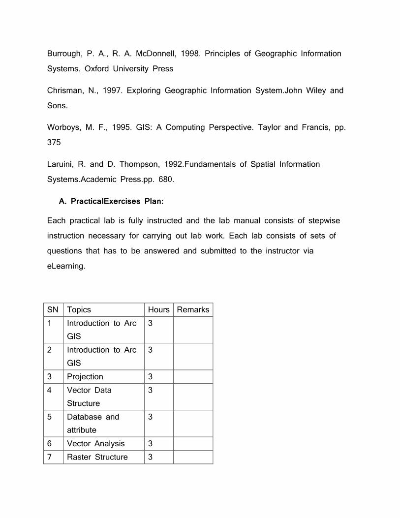
A. PracticalExercises Plan:
Each practical lab is fully instructed and the lab manual consists of stepwise instruction necessary for carrying out lab work. Each lab consists of sets of questions that has to be answered and submitted to the instructor via eLearning.
SN Topics Hours Remarks 1 Introduction to Arc
GIS 3
2 Introduction to Arc GIS
3
3 Projection 3 4 Vector Data
Structure 3
5 Database and attribute
3
6 Vector Analysis 3 7 Raster Structure 3
8 Raster Analysis 3 9 Visualization 3 10 Interpolation 3 11 Databases 3 12 Topographic
Modelling 3
B. Assignments:
Four to five class assignments will be provided to the students along with class works in some classes.
C. Evaluation:
Internal evaluation carries 50% of the marks while final exam is worth 50%
Internal Examination-2
Class Assignments-4
Presentation 1
Lab Assignments 12
Lab Exam 1
Attendance
GEOM 203: Field Surveys I (4 credits)
A four-week field camp will be held at the end of semester session III. During the field camp, the following field surveys will be performed:
1. Control survey

2. Leveling surveys (longitudinal leveling and cross sectioning) using Automatic level
3. Traverse surveys and Topographical Survey using Theodolite and EDM/Staves of Total station (Control surveys)
Emphasis is placed on practical and professional experience and knowledge in planning, scheduling, organizing and logistical aspects of field operations and instrument handling, care and adjustment and student’s active participation.
A group of six students will be formed for each field survey.
Each student is required to prepare and submit a complete report including computations and plotting of observation of each field survey.
THIRD YEAR
Ist Semester
MGTS 301: Engineering Economics, 3 credits
Objective:
The main aim of the course is to provide the knowledge on economics, cost concepts, money time relationships.
Detail course content:
1.0 Introduction to Engineering Economy Origin, principles, objectives and basis of engineering economy, engineering economy and design process, engineering economic analysis procedure, accounting and engineering economic studies

2.0 Cost Concepts and Design Economics Introduction cost estimating (top down & bottom up) and cost terminology (different types of cost: opportunity, sunk etc), the general economic environment (general economic terms; demand, supply, utility, value, luxury, necessity, monopoly, perfect market), break-even point, cost-driven design optimization. 3.0 Money-Time Relationships and Equivalence Introduction, simple and compound interests, Equivalence-concept, cash flow diagrams, simple interest formula for present, future and annual equivalents (singly cash flow, uniform cash flow, uniform gradient, deferred uniform gradient, uniform geometric ( only for single interest and discrete compounding), nominal and effective interest rate 4.0 Applications of Money-Time Relationship MARR, PW, FW and AW method, IRR and ERR method, payback period method 5.0 Comparing Alternatives Analysis & comparison of project using IRR, NPV, PW, FW, and AW: Useful lives equal to study period, useful lives are different among alternatives, mutually exclusive combinations of projects. Replacement Analysis: Reasons and factors for replacement studies, economic life. 6.0 Cost & Benefit Estimation Techniques Integrated approach to develop the net cash flows, parametric cost estimating, cost estimation in the design process, value engineering. 7.0 Analysis of alternatives with benefit cost (B/C ratio) 8.0 Depreciation concept and terminology; Classical depreciation methods 9.0 Dealing with Uncertainty Risk and uncertainty, sensitivity analysis

Internal Evaluation plan (Total 25 marks)
Internal Exams (two): 15 marks, Assignments: 5 marks and Term paper: 5 mark
References
WG Sullivan et al, Engineering Economy Chan S. Park, Contemporary Engineering Economics GEOM 316: Photogrammetry, 4 credits Objectives: The main aim of the course is to provide the knowledge on optics of photogrammetry, processing of aerial photography, aerial camera and digital photogrammetry.
Detail course content:
1.0 Optics of photogrammetry: Definition of Photogrammetry, types, development, scope, application, lens equation, lens errors, lens distortion, lens aberration, effect in image quality, complimentary colour filter, lens equation, real and virtual image, depth of focus, reflection, refraction, refractive index 2.0 Photography and processing of Aerial photography: Characteristics of photo emulsion, Conventional B/W processing, colour film processing techniques, assessment of quality of photography, resolution, Brightness, contrast, printing and duplication, printing of diapositives 3.0 Human eye and stereoscopic vision: Human eye, characteristics, functions of different parts, stereoscopic vision, parallax, application of stereovision and parallax in photogrammetry. 4.0 Basic Photogrammetry: Difference between aerial photographs and maps, Photo mosaics and photo maps, compilation of topographic detail from aerial
photographs, Role of photogrammetry in mapping,Geometry of vertical aerial photograph, Photo centre, Principle of perspective geometry, bundle of rays, collinearity condition,Forward and side overlaps, concept of model, types of aerial photographs, scale of a vertical aerial photograph, distortion in a photograph,effect of relief and tilt displacement, rectification, scale of tilted photograph, Oblique photography 5.0 Aerial Camera: Structure of aerial camera, functions, different types of analogue digital camera and their outputs. 6.0 Terrestrial Photogrammetry: Basic principle, procedures, stereometric camera, photo theodolite, recent development in terrestrial photogrammetry and its application 7.0 Aerial Photography Planning: Extension of control for photogrammetry, Requirement of GCP in plan and height pattern and distribution, pre pointing and post pointing, Common types of signal used for signalling, ideal GCP, Field records and maintenance, Accuracy standards of GCP,planning for aerial photography, Planning for flight lines and exposure details, factors to be considered, Brief idea of navigation system, Forward motion compensation technique, Indexing of aerial photographs on a map 8.0 Analogue photogrammetric process Orientation: Interior orientation, relative orientation, absolute orientation 9.0 Aerial Triangulation: Planning of aerial triangulation, transfer of points to photographs, Selection of points for aerial triangulation, observation of independent model, strip and block, strip adjustment, Bundle block adjustment, Analytical method, analysis of results 10.0 Aerial Photo Interpretation 11.0 Mapping: feature extraction and compilation. 12.0 Digital Photogrammetry: Digital Photogrammetry and its advantages, Digital photogrammetric workstations and its configuration, Interior orientation, Exterior orientation, measurements of GCPs, Image matching, tie points, Aerial triangulation, DEM generation and editing,. Orthophoto and orthomap production,

2D and 3D feature extraction, fields of application Practical/ Lab
1. Demonstration of analogue photogrammetric instruments and practising 3 D vision
2. Orientation (interior/Exterior) in Digital Photogrammetric Workstation 3. DEM generation and editing, Orthophoto and orthomap production, 4. 2D & 3D Feature extraction
References Photogrammetry: Paul R. Woulf
Mannual of Photogrammetry: ASPRS
Digital Photogrammetry: T. Schenk
GEOM303: Engineering and Construction Surveys, 3 credits
Objectives:
This course has been designed with the objective of providing the basic knowledge Engineering and construction survey: The objective of this course is to provide basic Concept of Engineering survey and to provide the basic concept of construction survey.
Detail course content:
1.0 Route Surveying
Introduction, Map planning and field
Recce and Field procedurepreliminary and detail survey, Location survey
2.0 Hydrographic surveying

Introduction, TidesShoreline surveys, Soundings Tidal current surveys Tidal current surveys
the capacity of a reservoir or Lake River surveying (stream gauging) 3.0 Mining Survey
4.0 Construction Surveys
Horizontal and vertical control networks Mining methods (gyroscope method) Introduction and definition of related basic terms Intake, Catchments area, Canal, Alignment, Grading Fore bay, Pen stoke, powerhouse, Tail rest 5.0 Construction Surveys
Fore bay, Pen stoke, powerhouse, Tail rest
6.0 Problem of road survey in Nepal. Service station, Stream gauging, Velocity discharge, layout Bridge abutment, earth work, cut, fill, embankment, burrow pit, Equipments for setting out 7.0 Construction Surveys
Horizontal and Vertical control Setting out of Pipeline, Setting out of Buildings and Structures, Staking out culverts, Setting out of Tunnels
8.0 Tachometric Surveying:
Staking out of a Highway, Bridge survey, miscellaneous construction surveys, Sources of error in construction surveys, Introduction, Instruments, Different Types of Tachometric measurement, Principle of stadia measurement, Determining of Tachometer constants 9.0 Tachometric Surveying:
Effects of error in stadia tacheometry Uses of Tacheometry 10.0 Areas and Volumes
Introduction
Volume from spot levels Volume by Simpson’s formula 11.0 Curves
General equation of a parabolic curve Methods of measuring area Methods of measuring Volumes
Computation for a unequal tangent curve High or low point on a vertical curve Design of a vertical curve, Sight distances of a vertical curve
Vertical curve
General equation of a parabolic curve Computation for a unequal tangent curve
High or low point on a vertical curve Design of a vertical curve Sight distances of a vertical curve
Seminar + Viva
Sight distances of a vertical curve and Sight distances of a vertical curve
Reference
Fundamentals of surveying, S.K Roy, Prentice Hall of India, India. Surveying Volume 1, Dr. B.C. Punima, Ashok. K. Jain and Arun. K. Jain,
Laxmi Publications, India Text book of Surveying; C. Venkatramaiah, University press (India) limited Construction Survey,Ervine Presentation Slide
Online sources
GEOM 314: Engineering Project IV 2 credits
The main objective of the Engineering project IV is to make the students familiar on mapping with application of GIS and remote sensing and some programming. The students are dvivided into groups consisting of 4-5 members. They have to carry out proposal defense , midterm defiance and final defense for completion of the projects. The Geomatics faculties will observe and evaluate all the work related with the project.
GEOM 317: Physical Geodesy, 3 credits
Objectives:
The main objective of the course to provide the knowledge on space Geodesy, physical geodesy, mathematical geodesy and Gravimetry.
Detail course content:
1. Space Geodesy:
Evolution of the Universe, the Big-Bang theory, time and space, Galaxy, Protoplanetary disk, solar system, sun, mercury, venus, Earth, mars, Jupiter, satrun, Uranus, Neptune and Pluto, their natural satellites and missions on them.
2. Physical Geodesy:
Fundamentals of potential theory, Newton’s law and Newtonian Potential, Harmonic function and Gravitational potential in terms of spherical harmonics, Gravitational potential in terms of MOI, Laplace equation and solution of Laplace equation in rectangular and spherical coordinate, Legendre differential

equation, Legendre function and its use for gravitational potential, Poisson’s equation for gravitational potential, zonal, sectoral and Tessaral, spherical harmonics, Dirichlet’s Problem, Neumann’s Problem and their solution
3. Gravity field of the earth
Gravity and centrifugal force on the surface of the earth, gravity and centrifugal force from gravitational potential, generalized poisson’s equation, level surface, gravity anomaly, deflection of vertical, plumb line, equipotential surface, geoid, curvature of level surface and plumb line, normal gravity, Somigliana’s formula
4. Geometrical Geodesy:
Reference system, Coordinate system, ITRF, ECEF, sphere and spherical triangle, triaxial and rotational ellipsoid and their geometry, Geodetic coordinate system, othometric and normal height, astrogeodetic method, best fitting ellipsoid, coordinate, length, area, volume on ellipsoid, coordinate transformation from rectangular to geodetic and vice versa, determination of arc length of an ellipsoid.
5. Mathematical Geodesy:
Introduction to differential geometry, space curves and surfaces, Gaussian elements, Curvatures
6. Gravimetry: Gravimeters and their principle, Gravity reduction, Bouger reduction, Isosatsy, EGM-96, Gravity anomalies
Evaluation Scheme:
Total Lectures
32Hours Written Exam (25)
Tutorial + Practical (15)
Attendance
Internal Assesment
50 Marks 3 exams of each 25 Marks
Field work + computation
5 marks

and average of them
and report submission
End semester Exam
50 Marks
GEOM 318: Spatial database management, 3 credits Objectives:
The topics covered in this subject will include: the fundamentals of non-spatial and spatial databases; spatial data modeling including entity-relationship models; query languages and query processing. On successful completion of this subject students will be able to describe basic concept of database technology, to describe the need for spatial databases, and the differences between spatial and non-spatial database systems, describe the design and principles of spatial databases, including techniques for efficiently storing and retrieving spatial data and use and customize specific spatial and non-spatial database systems.
Detail course content:
1.0 Introduction to DBMS
General overview of DBMS, Terms and Terminologies, Applications of DBMS: Where and how it is use, Comparison with other data technologies, Database technology for geospatial data, Basic characteristics of a DBMS, components of DBMS, functions of DBMS, interaction with DBMS
2.0 Data Models, database languages
Introduction to data models, basics of ER model, relational model and other models, database languages types, Basic concepts, constraints, keys, design issues, entity-relationship diagram, weak entity sets

3.0 Relational data model
Terminologies, need of relational data model, relational database, constraints, keys
4.0 SQL
Background, Basic structure, set operations, aggregate functions, null values, nested sub queries, views, modification of database, joined relationships, data-definition languages
5.0 Spatial database technology Introduction, differences with traditional (non-spatial) DBMS, values of SDBMS, users of SDBMS, modeling spatial data in traditional DBMS, how SDBMS different from a GIS 6.0 SDBMS components Spatial taxonomy and data models, spatial query language, standards, and data mining
7.0 Spatial data handling
Spatial data handling, operations on spatial data
8.0 Spatial database design
Reality and databases, classical database design, conceptual data models, data modeling, DBMS platforms and standardization, data model with spatial notions, spatial data handling, operations on spatial data Practical:
Practical 1: Familiarizing with user interface of MS Access, basic operations
creating tables Practical 2:
Introduction to SQL and databases PostgreSQL installation Creating a database and table with SQL Insert and retrieve data in table with SQL Update and delete data in table with SQL Insert and retrieve data in table with SQL
Practical 3:
Introduction to spatial databases PostGIS installation Creating a spatial database Loading spatial data Viewing the spatial data in QGIS Geometry types Spatial operations
Practical4:
Use of SQL aggregated functions in retrieval of data from table Grouping of data with SQL (Group by. having, order by, etc.) Joining of tables with SQL Advanced joins Spatial joins Spatial indexes
Practical 5:
Projecting data Geographic coordinates Geometry functions Advanced spatial joins Data quality checks
Practical 6
Configuring PostgreSQL for Spatial Practice with own data Start assessment project
References
Presentation slides (power point) Book
o Sliberschatz, Korth and Sudarshan, Database system concepts, McGraw-Hill
o Chris J. Date, An Introduction to Database Systems, Addison-Wesley Publishing Company, 1975, seventh edition (2000).
o Ramez A. Elmasri&Shamkant B. Navathe, Fundamentals of Database Systems, Benjamin/Cummings Publishing Company, second edition (1994).
o Raghu Ramakrishnan, Database Management Systems, McGraw-Hill, (1997).
o Ryan K. Stephens & Ronald R. Plew, Database Design, Sams Publishing, (2001).
o Jeffrey D. Ullman, Principles of Database and Knowledge-base Systems, Volume I, Computer Science Press, (1988).
o ShashiShekhar, Sanjay Chawla, Spatial database a tour. Pearson Education.
o P. Rigaux, M. Scholl and A. Voisard, Spatial Databases with applications to GIS, Morgan Kaufmann Publishers, 2002
Internet and online sources (self exploratory)
THIRD YEAR Second Semester

GEOM 306: Land Administration, 3 credits
Objectives
The main objective of the course to provide the knowledge on land and society, Land Administration and Land policy, modernization in land administration.
Prerequisites:The students should have the concepts of spatial data base management
Detail course content:
1.0 Land and the society
Land definition, concepts surrounding land, Man-Land Relation, Land administration in domain model Importance of land and property, Land and Economics
2.0 Land Administration and Land Policy
Definition Of LA, Functions of LA, Data in Land Administration system, Land policy, objective of land policy, Land policy instrument; Land market, Land market imperfection, players in land market, modeling the land market land, Land use planning, land tenure, Land Value, community and land policy, Nepalese national land policy and its objective
3.0 Land Tenure and Property
The nature of property and rights in land, definition, Tenure definition, property in the context of land tenure, Land law, property regimes, rights, forms of tenure system, Tenure security, categories of interest etc. Parcel definition and

unit of record, Nepalese land tenure system, Tenure system of various countries 4.0 Formalizing Property Rights
Formal and informal property, property formalizations; Land reform, Land titling, benefits of land formalising and land titling, requirements of land titling, adjudication. 5.0 Land and Property Right Transfer Process
Land and real property description, Land Registration and its function, Types of land registration; Private conveyance and registered conveyance (Registration of deed and registration of title), Characteristics of Land registration system of Nepal, Demerits of private conveyance, land and property right transfer process, parcel subdivision and subdivision process, land fragmentation, and multiple ownership. 6.0 Land Administration and Management Issues
Local Governance and its principle, land less and squatter settlement, Land Acquisition, Transparency in Land Administration system, Licensing, Public-private Participation, Privatization and Re-engineering.
7.0 Land Conflict and Resolution
Land conflict definition, root cause of land conflict Boundary dispute, Land disputes, ownership dispute, Different case study, Informal institution, Mediation, Arbitration and their role in land dispute and conflict resolution, Land court and its role in dispute and conflict resolution, Prevailing acts and rules relating to Nepal’s Land System and conflict resolution 8.0 Modernization in Land Administration
Determination of user needs, Restructuring of administrative and organizational structure, Legislative reforms, Surveying Land and property boundaries, Land Information management, Central VS decentralize system, LIS and its need,

Goal if LIS, UML for cadastral systems, use case diagram and activity diagram etc., Developing awareness in the user community, Appropriate education and training, role of professional Associates, land administration and local governance, Important world summits, and conferences on land administration and declarations.
References
Land Administration, P.F. Dale and J.D Mc Laughlin, Oxford University press.
Land Tenure in development cooperation guiding principle.GTZ GmbH, Germany
Land Law and Registration, S. Rowton Simpson, Surveyors publication, London
Land registration in Neplease perspective, B.L Shrestha Land Registration Tools for L.S.G Larsson. Land Administration Guideline- United Nations The law of property, K.K. Menon Land ownership in Nepal , M.C. Regmi Land tenure and taxation in Nepal, M C Regmi, and Himalayan
Bibliotheca. Handout and lecture notes Internet and online sources (self exploratory)
GEOM 307: Theory of errors & Adjustment, 2 credits
Objectives

The main objective of the course to provide the knowledge on measurement process, projection and co-ordinate transformation, Blunder defection and horizontal network.
Detail course content:
1.0 Measurement Process
Linear/Mechanical/EM
2.0 Measurement Process& Errors
ODM/Vertical &Horizantal eye
3.0 Properties of Random Variable
4.0 Confidence Intervals& Sampling Theorey
5.0 The Principle of least square, normaleye, weights.
6.0 Application of Statistical Principles to Surveying
7.0 Projection & Co-ordinate Transformation
8.0 Blunder Defection &Horizontal Network
9.0 Computer Optizazation
Assignment Test/Group presentation
References
Handout and lecture notes Internet and online sources (self exploratory)
GEOM319: Computational methods in Geomatics, 3 credits
Objectives
The main objective of the course is to provide the knowledge on Java programming, interfaces and inner classess graphical programming and event handling.
Detail course content:
1 Introduction 1.1 Java: Introduction, history, and philosophy
Lecture Hour 1.2 Downloading and installation 4 1.3 Java development kit (JDK), Java virtual Machine (JVM) 1.4 Java IDEs 1.5 Eclipse: Download and installation of Eclipse
2 Fundamental programming structures in Java
2.1 A simple java program 4 2.2 Data types, variables, operators 2.3 Strings 2.4 Input and output 2.5 Control flow: conditional statements, loops, switch, break 2.6 Big numbers 2.7 Arrays
3 Objects and classes
3.1 Introduction to Object-Oriented programming 4 3.2 Predefined classes 3.3 Defining your own classes 3.4 Static fields and methods 3.5 Method parameters

3.6 Object construction 3.7 Packages
4 Inheritance
4.1 Classes, super classes and subclasses 6 4.2 Inheritance hierarchies 4.3 Polymorphism 4.4 Dynamic binding 4.5 Preventing inheritance: Final classes and methods 4.6 Casting 4.7 Abstract classes 4.8 Object wrapping
5 Interfaces and inner classes
5.1 Interfaces: Properties, interfaces and abstract classes 4 5.2 Object cloning 5.3 Interfaces and callbacks 5.4 Inner classes
6 Graphics programming and Event handling
6.1 Introducing swing 8 6.2 Frames: Creating, positioning, properties 6.3 Working with 2D shapes, using colour and special fonts 6.4 Displaying images 6.5 Basics of event handling 6.6 Actions 6.7 Mouse events 6.8 AWT event hierarchy
7 Applet
7.1 Standard applet methods 6
7.2 Putting an applet on a web page 7.3 Creating an applet 7.4 Sending parameters from a web page 7.5 Handling Parameters in an applet
8 Database connectivity 4
8.1 Database basics 8.2 Connecting to a database with jdbc 8.3 Querying and manipulating databases with jdbc
9 Exception handling 2 9.1 Dealing with errors 9.2 Catching exceptions
GEOM313: Modern Cartography, 3 credits
Objectives
The main objective of the course to provide the knowledge onMap reproduction techniques,Web mapping and Multimedia Cartography.
Detail course content:
1.0 Introduction, Dissemination and Use issues
Dissemination formats, Maps for dissemination of geo-data, Map use goals, dissemination of maps 2.0 Map reproduction techniques
Planning ahead, map editing, raster image processing for print production, screening for print reproduction, Halftone and stochastic screening, Aspects of

color printing-process color, spot colors, high-fidelity process color, continuous tone color printing, Color management system, high volume print reproduction-pre-phase phase, file formats, proofing methods, offset lithographic printing, computer to-plate , direct-to-plate
3.0 Web mapping
Introduction, types of web maps- static , dynamic, animated, interactive, collaborative, interoperability, OGC standards for web mapping, web map design
4.0 Mapping time
Concept of time, representation of change, single static map, multiple static map, animated map, dynamic visualization terminology, dynamic visualization variables, cognitive issues, goal of animation design
5.0 Mini-project
Mini-project: Thematic map design. Socio-Economic Maps of Asia
6.0 Multimedia Cartography
Introduction, paradigm of multimedia cartography, elements of multimedia cartography, design of multimedia mapping products
7.0 Atlases
Paper atlases, electronic atlases, electronic atlas types, atlas information system, web atlases
8.0 Geovisual exploration/analytics
Visualization and maps, geovisualization, geovisualization and maps, brushing-attribute, geographical, temporal, exploratory tools, visual analytics

9.0 Map Use, User, Usability
User centered design of geo data dissemination systems, use contexts, user data collection and analysis methods, types of map use research
Field Trip
Visiting Cartography section at Survey department to observe overall process of map making.
References
Kraak MJ and Ormeling (2010), Cartography the visualization of spatial data
Slocum et al. (2009), Thematic Cartography and Geovisualization
Internet and online sources (self exploratory)
GEOM315: Satellite Geodesy, 3 credits
Objectives:
The main objective of the course to provide the knowledge on various satellites, reference and co-ordinate system, satellite ranging and satellite tracking.
Detail course content:
1.0 Introduction, history of satellite observation and findings Reference system and coordinate system
2.0 Introduction to Astrodynamics, Newtonian mechanics, Two body problem, circular orbits, geostationary
satellites
3.0 Kepler’s laws of planetary motion, Kepler’s law from Newtonian mechanics, Keplerian 4.0 Orbital element and their determinations 5.0 Perturbation and perturbed satellite motion, Sun and Moon, Solar Radiation Pressure, 6.0 Atmospheric Drag, use of perturbation 7.0 Ground track and Orbit determination and parameter estimation from two
position vectors, from three sets of angles, Kalman filtering
8.0 Satellite ranging and satellite tracking; Laser ranging, principle and applications of Laser ranging, introduction to satellite Altimetry, Space technique and BLBI principle
9.0 Selected sections of Global Navigation Satellite System, introduction and principle of GPS, DGPS, Galileo systems, applications of GPS in different industries.
10.0 Geodetic Space techniques, basic principle, fundamental stations, Integrated Global 11.0 Geodetic Observing System (IGGOS) 12.0 Introduction to differential Geometry, Curves and surfaces in space, curvature (optional) References
Handout and lecture notes Internet and online sources (self exploratory) GEOM 304: Field Survey II, 4 credits
A four-week field camp will be held at the end of the semester V.
During the field camp, the following field surveys will be performed:
1. Engineering and construction survey,

2. highway alignment, canal survey, tunnel survey, pipeline survey, 3. curve setting, Tacheometry survey, boundary survey problems, 4. contouring, plane tabling,
Emphasis is placed on practical and professional experience and organizational, planning, scheduling, and logistical aspects of field operations and student’s active participation.
Each student is required to prepare and submit a complete report of each field survey including computations and plotting of observations.
GEOM 310: Cadastre, 3 credits Objectives:
After completion of this course, the students should be able to understand the basic concepts, principle, working methodologies and application of Cadastre, explain analogue and digital cadastral procedures, plan, perform and supervise cadastral survey and prepare cadastral documents and database. Detail course content
1. Introduction:
Historical Background, Development of Cadastral System, Concept of Cadastre and Cadastral survey, types of Cadastre, Cadastral system (analog and digital), importance of Cadastre.
2. Parcel and Boundary: Definition of parcel, parcel as a unit of land, parcel numbering system, unique ID, Boundary, types of boundary, boundary demarcation.
3. Components of Cadastre: Cadastral maps and their types, Field books, Registers, Title documents, Schema and databases, Cadastral data model

4. Technical requirements for Cadastral Survey: Approach of cadastral survey: sporadic vs systematic, free sheet vs trigonometrically controlled sheet, isolated vs seamless cadastral data, Projection System, Geodetic Network, Control points, Map sheet numbering system, technical specifications, Standards
5. Cadastral Survey Methods: Annotation on existing map/image, chain/tape, compass, Plane table alidade, Total station, Photogrammetry, GPS method, Hybrid method, comparison of different methods
6. Cadastral Survey Procedure and workflow: Establishment of Control Points, Notification and Awareness, interaction with local community, Adjudication, Demarcation, Measurements, Recording, Map preparation, Documentation, Cadastral data modeling and database preparation, land parcel registration, preparation of ownership documents (Analogue and digital method)
7. Land Registration Process: Conveyancing, Registration of deed, registration of title, registration process
8. Updating and Archiving Cadastral Documents: Map tracing, Parcel subdivision, parcel history maintenance, file map, parcel map, plot register maintenance, database maintenance
9. LIS:
Introduction to LIS, components of LIS, Role of LIS, Data sources, Data acquisition, data preparation, data model, data maintenance, Dissemination and use of data, LIS stakeholders and their role, Benefits of LIS
10. Cadastral system of Nepal Analogue cadastral system, Digital cadastral system, Maintenance of cadastre, LIS in Nepal, Organization involved in cadastral system, Legal framework for cadastral system
11. International Practices:

Examples of modern cadastral system implemented around the world, International professional organization in Cadastral Surveying, International conventions and declarations in cadastral surveying, ethics, professionalism and code of conduct.
References Handout and lecture notes Internet and online sources (self exploratory)
Year IV Semester I
GEOM 401: Survey Project Management, 3 credits Objectives
The main objective of the course to provide the knowledge on various satellites, reference and co-ordinate system, satellite ranging and satellite tracking.
Detail course content
General Management Introduction, Basic Principles of management, Techniques of management Management theory, Inventory Management, procurement management, office management Human personality
Leadership, Motivation, dynamics of organization, effectiveness and innovation
Fundamental rights and human value

Directive principle of Nepalese interim constitution, Fundamental rights, Duties and responsibilities, Human values, Social justice and equity, Gender justice and equity, Woman at work places, Childrens right, intenational laws on human rights, Universal decleration of human right (1948),
International human right organizations National human right commission and basic principle Public relation and communication skill Introduction and basic concepts, methods of public relation, designing public relation programmes, Efficient communication skills, verbal communications, drafting, qualities of public relation officers, Coordination skills and networking between different user groups, needs of subordinates and attitude, discipline, morale, and grivience handling Human resource management Survey Management Introduction, ToR Technical standards and specification, project planning, project design and implementation, project phases, types and project cycle, stress management, time and resource management, Crisis resolution Safety management Related intenational communities and their activities
Assignments: Case study/ Individual presentation
References:
Essentials of Management: J.L. Massie
Project planning and Management: L.J. Goodmen and R.N. Love
Project Management: GovindaAgrawal
Administration, Management and Development: K.B. Raut (in Nepali)
GEOM 402: Remote Sensing, 3 credits

Objectives: The course objective is to introduce the modern quantitative approach of survey technique. It uses remote sensing techniques in optical, infrared and microwave radiation zones. At the end of the course the students gains theoretical knowledge and practical approach on information extraction by the use of electromagnetic radiation. Detail course content
1.0. Introduction What is remote sensing? Why remote sensing? Types of remote sensing, historical perspective, Photo interpretation, quantitative analysis, evolution of ecosystem, spaced based ecosystem, Digital concepts 2.0. Radiation principles Electromagnetic radiation, Electromagnetic Spectrum, EM properties, classification of EMS, Physical principles of radiation in remote sensing, energy conservation principle, radiometric Terminology 3.0. Remote Sensing Systems: Spatial and radiometric characteristics, spectral characteristics, Temporal characteristics, Camera and Film System, Imaging sensor, sensor types, instrument response, spatial response, spectral response, PSF (optical, sensor, image motion, electronic), imaging system simulation, PSF measurement, spectral response, Signal amplification, sampling and quantization

4.0. Image Statistics: Uni-variate statistics (histogram, normal distribution, cumulative histogram), Multivariate statatistics, noise models, statistical measure of image quality (modulation, SNR, contrast), Spatial statistics (covariance and semi-variogram), power spectral density, Co-occurrence Matrix, fractal geometry, topographic and sensor effects (topography and spectral scattergrams, Sensor Characteristics and Spatial Statistics, Sensor Characteristics and Spectral Scattergrams 5.0. Radiometric distortion Sources of Radiometric Distortion, The Effect of the Atmosphere on Radiation, Atmospheric Effects on Remote Sensing Imagery, Instrumentation Errors, Correction of Radiometric Distortion, Detailed Correction of Atmospheric Effects, Bulk Correction of Atmospheric Effects 6.0. Geometric distortions Sources of Geometric Distortion, Earth Rotation Effects, Panoramic Distortion, Earth Curvature, Scan Time Skew, Variations in Platform Altitude, Velocity and Attitude, Aspect Ratio Distortion, Sensor Scan Nonlinearities, Correction of Geometric Distortion, Use of Mapping Polynomials for Image Correction, Mapping Polynomials and Ground Control Points, Resampling, Interpolation, Choice of Control Points, Mathematical Modelling-Aspect

Ratio Correction, Earth Rotation Skew Correction, Image Orientation to North-South, Correction of Panoramic Effects, Combining the Corrections, Image Registration, Georeferencing and Geocoding, Image to Image Registration 7.0. The Interpretation of Digital Image Data Approaches to Interpretation, Forms of imageries for Photo interpretation, Computer Processing for Photo interpretation, An Introduction to Quantitative Analysis-Classification, Multispectral Space and Spectral Classes, Quantitative Analysis by Pattern Recognition, Pixel Vectors and Labelling, Unsupervised Classification (Delineation of Spectral Classes, Similarity Metrics and Clustering Criteria,the Iterative Optimization (Migrating Means) Clustering, Algorithm,The Basic Algorithm, Merging and Deletions, Splitting Elongated Clusters, Choice of Initial Cluster Centre, Clustering Cost, Unsupervised Classification and Cluster Maps, Clustering Example, Single Pass Clustering Technique, Single Pass Algorithm, Advantages and Limitations, Strip Generation Parameter, Variations on the Single Pass Algorithm, Agglomerative Hierarchical Clustering, Clustering by Histogram Peak Selection), Supervised Classification (Steps in Supervised Classification, Maximum Likelihood Classification, Bayes' Classification, The Maximum Likelihood Decision Rule, Multivariate Normal Class Models, Decision Surfaces, Thresholds, Number of Training Pixels, Required

for Each Class, Minimum Distance Classification, The Discriminant, Degeneration of Maximum Likelihood to Minimum Distance Classification, Decision Surfaces, Thresholds, Parallelepiped Classification) 8.0. Map accuracy: The History of Map Accuracy Assessment, Positional Accuracy Thematic Accuracy Non-Site-specific Assessments Site-Specific Assessments, the Error Matrix Mathematical Representation of the Error Matrix, Sample Design Considerations, Appropriate Sample Unit, Reference Data Collection, Analysis Techniques Tutorial and Practical Practical should be followed by tutorial if necessary 1. Electromagnetic energy exercise- sensor design, spectral reflectance curve 2. Working with images- opening images, making colour combination, location value Extraction 3. Atmospheric correction- using dark object subtraction, empirical line and refined empirical line method 4. Geometric correction-GCP points, maps to image, image to image registration 5. Unsupervised classification- ISO data and K-means 6. Supervised classification-parallelepiped, nearest neighborhood, maximum likelihood 7. Accuracy assessment of supervised and unsupervised classification 8. Image operations -sub-setting in spatial and spectral domain, layer stacking

References Handout and lecture notes Internet and online sources (self exploratory) GEOM 405: WEB GIS, 3 credits
Objectives This explores web-based GIS to its very core. Both proprietary and Open Source Software will be used to provide students with a thorough knowledge of an up and coming aspect of GIS. This course will apply for understanding and applying the concepts and core technologies that allow the deployment of GIS functionality on the World Wide Web. The course aims to balance the understanding of concepts and principles with the acquisition of practical skills to allow students to create web-GIS applications and be able to provide significant contributions in professional interdisciplinary information science and technology teams. The theory and concepts are demonstrated and/or practiced using the latest GIS and web technologies. COURSE GOALS: The goals of this course are to: 1. Provide an overview and basic understanding of the most important Web-GIS principles and technologies that will allow you to effectively contribute to IT interdisciplinary teams designing and implementing Web-GIS applications. 2. Provide a “road map” of the area of Web-GIS that will allow you to decide what principles and technologies to explore and learn further to take your knowledge and skills to your desired level. 3. Allow you to create basic Web-GIS applications.

Prerequisites: There are no formal prerequisites, however, it is recommended that students take courses such as Introduction to GIS, programming in any language (e.g. C++, Java, PHP, Perl, or Python), and a class where basic web and HTML concepts are covered, before taking this course.
Detail course content
1. Introduction to Open Web Mapping Open Standards, Principals of Open Standards, Free and Open Source Software, Web Mapping
2. Distributed GIS Introduction, Distributed GIS, Centralized GIS systems vs. Distributed GIS Services, need of Distributed GIS, Basic components of a Distributed GIS. 3. Overview of core technologies to create Web-GIS systems. History of Internet, Networking Fundamental, Network environments: LAN, WAN, and the Internet, Network communication models and protocols: The TCP/IP model, Internet concepts & Internet GIS, Client/Server approach, Web-based client/server, Web Servers, Web Browsers , HTML. 4. Technology evolutions of Web mapping. Overview of important W3C, ISO, and OGC initiatives and Open Specifications, Importance of XML and its schemas, Introduction to the Geographic Markup Language (GML). 5. Overview of OGC Open Specifications. Introduction to OGC’s WMS, WFS, WCS, and WTS map services.
6.Web Map Service
Overview, Objectives, Introduction to Web Map Service, Web Map Service (WMS), The WMS Specification, GetMap , GetCapabilities, GetFeatureInfo information, The GetMap Request, The GetCapabilitiesRequest,Response to a GetCapability Request, The Service Section ,The Capability Section,The Requests Subsection, The Exception Subsection,The Layer Subsection, Spatial Reference Systems (SRS), The GetFeatureInfo Request, Web Map Clients
7. Web Feature Service
Overview, Objectives, Introduction to Web Feature Servers, The Web Feature Server Specification, Refresher on HTTP GET ,Introduction to HTTP POST, GetCapabilities Request, The Service Section, The Capabilities Section, The FeatureTypeList section, The Filter Capabilities section, The DescribeFeatureTypeRequest,TheGetFeatureRequest,GetFeature, WFS Clients and Servers ,Introduction to WFS Clients, List of WFS Servers
8. Interoperable Systems
Introduction, Interoperability systems, difference between interoperable system and Non Interoperable system 9. Extensible Markup Language
Overview, Introduction to XML, Objectives, Extensible Markup Language, Geographic Markup Language
10. Styled Layer Description (SLD)
Introduction, Styling, Styled Layer Description,SLD Documents, Styled Layer Description: Examples, Symbols,Symbolizers, Line Symbolizer,PolygonSymbolizer,Point Symbolizer, Text Symbolizer,Rasters

11. Building a Web Mapping Application
Overview, Define the Application, Assess and Collect Data, Determine the Software Download and Install the, Software, Install Data, Test Software and Data. 12. Future impact of Web-GIS and GIS Web Services.
References: Peng, Z. and Tsou M. 2003 Internet GIS: distributed geographic information services for the Internet and wireless networks. Hoboken: John Wiley & Sons. Erle S., Gibson R. and Walsh, J. 2005.Mapping Hacks: Tips & Tools for Electronic Cartography. O'Reilly. Mitchell, T. 2005. Web Mapping Illustrated. O'Reilly. Online Resources
GEOM 408: Environmental Modeling: Elective, 3 credits
Objectives
The main objective of the course to provide the knowledge on environmental remote sensing system, classification of hydrological modeling and process based environmental modeling.
Detail course content
1.0 Introduction
Taxonomy of models, approaches in modeling, types of models, model verification, validation, calibration and Sensitivity analysis
2.0 Environmental remote sensing system

Data and data representation, remote sensing system classification, relevance to environmental modeling, scaling of data, Data sampling and interpolation, surface data analysis, surface representation
3.0 Spatial data interpolation for Zinc pollution
Environmental decision making, Decision support system (DSS), uncertainty in decision making, GIS as a tool in DSS
4.0 Classification of hydrological modeling
Rainfall runoff modeling, hydrological cycles, method to estimate different rainfall runoff parameters , calibration, validation, sensitivity analysis, meteorological parameters, surface runoff parameters, HEC HMS introduction
0.0 Surface analysis
Terrain preprocessing, data preparation using HEC-GEOHMS, Hydrological modeling with HEC HMS
1.0 Process based environmental modeling
System thinking and practice, system dynamics, Causal loop diagramming, Stella modelling
Causal loop diagramming, System dynamics using STELLA, Biomass and Productivity estimation based on remote sensing data, LAI, NDVI, empirical models use
7.0 LAI estimation from LANDSAT images for biomass estimation using ArcGIS
Uncertainty in Modeling, Modeling Issues, Data quality issues, uncertainty and sensitivity analysis
8.0 River Quality Determination
References
Handout and lecture notes Internet and online sources (self exploratory) Field Survey III: GEOM 404, 4 credits A four-week field camp will be held at the end of semester session VII. During the field camp, the following field surveys will be performed:
1. GPS, Control points by DGPS 2. Thematic mapping 3. Precise leveling surveys 4. Star observation 5. Digital cadastre 6. Analogue cadastre 7. Land registration and ownership documents preparation 8. Astronomical observations (Polaris, solar and other star
constellation) 9. Observation to determine azimuth, latitude, longitude and time. 10. Spatial data capturing by GPS receiver for variety of applications,
downloading, computations and plotting of observations.
Emphasis is placed on practical and professional experience and knowledge in planning, scheduling, organizing and logistical aspects of field operations and instrument handling, care and adjustment and student’s participation.
A group of six students will be formed for each field survey.
Each student is required to prepare and submit a complete report of each field survey including computations and plotting of observations.
CIEG 405: Entrepreneurship Development and Ethics, 3 credits Objectives The main objective of the course to provide the knowledge on challenges of entrepreneurship preparing the business plan, sources of funding and to provide the knowledge on ethics and professional practice, fundamental rights and human value, international communities and their activities.
Detail course content
Chapter 1: The Foundations of Entrepreneurship
The World of Entrepreneur What is an Entrepreneur? The Benefits of Entrepreneurship The Potential Drawbacks of Entrepreneurship Behind the Boom: What’s Feeding the Entrepreneurial Fire? The Cultural Diversity of Entrepreneurship The Power of Small Business The Ten Deadly Mistakes of Entrepreneurship Putting Failure into Perspective How to Avoid the Pitfalls
Chapter 2: Inside the Entrepreneurial Mind: From Ideas to Reality
Creativity, Innovation, and Entrepreneurship Creativity – A Necessity for Survival Creative Thinking Barriers to Creativity How to Enhance Creativity
The Creative Process Techniques for Improving the Creative Process Intellectual Property: Protecting Your Ideas
Chapter 3: Designing a Competitive Business Model and Building a Solid Strategic Plan
Building a Competitive Business Model and Building a Solid Strategic Plan
The Strategic Management Process Chapter 4: Conducting a Feasibility Analysis and Crafting a Winning Business Plan
Conducting a Feasibility Analysis Why Develop a Business Plan? The Elements of Business Plan What Lenders and Investors Look for in Business Plan Making the Business Plan Presentation Business Plan Format
Chapter 5: Forms of Business Ownership
Brief Introduction to Various Forms of Ownership Chapter 6: Building a Powerful Marketing Plan
Building a Guerilla Marketing Plan Pinpointing the Target Market Determining Customer Needs and Wants through Market Research Plotting a Guerilla Marketing Strategy: How to Build a Competitive Edge Marketing on the World Wide Web The Marketing Mix

Chapter 7: Pricing Strategies Three Potent Forces: Image, Competition and Value Pricing Strategies and Tactics Pricing Strategies and Methods for Retailers Pricing Concepts for Manufacturers Pricing Strategies and Methods for Service Firms The Impact of Credit on Pricing
Chapter 8: Creating a Successful Financial Plan
Basic Financial Statements Creating Projected Financial Statements Ratio Analysis Interpreting Business Ratios Break-Even Analysis
Chapter 9: Managing Cash Flow
Cash Management Cash and Profits Are Not the Same The Cash Budget Preparing a Cash Budget The ‘Big Three’ of Cash Management Avoiding the Cash Crunch
Chapter 10: Sources of Financing: Debt and Equity
Planning for Capital Needs Equity Capital versus Debt Capital Sources of Equity Financing The Nature of Debt Financing
Chapter 11: Choosing the Right Location and Layout
Location: A Source of Competitive Advantage
Location Criteria for Retail and Service Businesses Location Options for Retail and Service Businesses The Location Decision for Manufacturers Layout and Design Considerations Layout: Maximizing Revenues, Increasing Efficiency, or Reducing Costs
Engineering Professional Practice and Engineering Ethics
Chapter 12: Ethics and professional practice
Ethics, moral and non-moral actions, Profession, features of profession, professional engineering, code of ethics and guidelines for professional engineering practice
Role of professional associations
Professional engineering, definition of engineer, Nepal engineering council, Nepal engineers association, Surveyors’ association
Fundamental rights and human value
Directive principle of Nepalese interim constitution, fundamental rights, duties and responsibilities, human values, social justice and equity, gender justice and equity, Women work at places, children right, universal declaration of human rights (1948), Human right organizations, national human right commission and basic principles
Role of international communities and their activities
International organization of geodesy (FIG), International society of photogrammetric and remote sensing (ISPRS), Asian association of remote

sensing, Permanent committee on GIS infrastructure for Asia and the Pacific (PCGIAP), International steering committee for global mapping (ISCGM), International organization for standard (ISO)
Assignment
Case studies and a small study in a group of 4 members
References: Rajendra P. Adhikari (2010), Engineering Professional Practice Related associations/societies/councils publications Interim Constitution of Nepal Related websites Essentials of Entrepreneurship and Small Business Management, 5th
Edition Thomas W. Zimmerer and Norman M. Scarborough
GEOM 406: Spatial Data Infrastructure, 2 credits
Objectives
The main objective of the course to provide the knowledge on principle of SDI, standards for SDI, meta data and SDI Guiding principle.
Detail course content
1.0 Principle of SDI
What is SDI, need of SDI, effects of SDI, SDI components,Distributed geospatial databases, Metadata, communication networks, Inter-operability among hosts, operating systems, data sources and structures
2.0 Standards for SDI

International Organization of Standardization (ISO TC 211, TC 204, JTC-1), World Wide Web Consortium (W3C), Open Geospatial Consortium (OGC), National Standards Organizations, distributed computing with web services, OGC web service, SDI architectures based on OSS, OGC services architecture,
3.0 Meta data
Principles, levels of metadata, linkage between geospatial data and metadata, metadata standards, implementation approach, implementation issues: vocabularies, gazetteers and thesauri
4.0 Geospatial data catalogue
Principles, catalogue server/service development, available software implementations, catalogue gateway and access interface development, registering catalogue servers
Demonstration of geonetwork: an open source data catalogue
5.0 SDI guiding principles (INSPIRE)
Data stewardship, data security, data accessibility, data interoperability, data reusability, data synchronization, data availability, data discoverability, data validity, data rights, data usability
Geospatial data visualizations: online mapping
6.0 Open GIS web mapping activities, map servers, available software, Geoportals Overview, geoportal service requirement: portrayal services, data services, catalogue services
Data access and delivery: open access to data
7.0 Policy and organizational structure

Organizational approach, implementation approach
Institutional arrangements (policies, standards) and organizational changes
8.0 case studies from established SDIs Overview of emerging technologies in SDI. Topic selection for seminar
Web 2, Cloud computing, Local Based Services, SOS, VGI.Overview of topics for seminar.
Assignments
Group work and reserach for presentation Group work and research for presentation
Overview of trends in SDI
SDI in context of Nepal, emerging technologies for development of SDI, Application of SDI in climate change and disaster management, role of social media for SDI
References
Presentation slides (power point) Book
o SDI Cookbook Internet and online sources (self exploratory)
Elective GEOM 409: Hydrological Simulation and Modeling, 3 credits
Objectives
Upon the completion of this course, the students will be able to differentiate between system, model and simulation, explore how a system manifests itself in a geographic phenomena for example in an elevation phenomena, soil

salinity phenomena or flood hazard phenomena, understand Terrain and analyze it, calculate viewshed and watershed, model a given geographic phenomena using process modeling techniques, here particularly hydrology model and simulate the given model to generate the virtual scenario in this case flood hazard model, water inundation model.
Prerequisities: CEEG201
Detail course content
1.0 Definition of system, model and simulation and difference (Theory: 3 hours)
2.0 Terrain analysis and calculation of viewshed and watershed (Theory: 3 hours)
3.0 Modeling techniques and types, model components, definition of process model, application of GIS and remote sensing in modeling, generating model for generalizing classified land use/ land cover polygon raster features (12 hours including practical 9 hour)
4.0 Process model for suitability modeling, Hydrology modeling: Components of hydrology model, generation of terrain model using different techniques, calculation of filled DEM, Application of map algebra in hydrology modeling, generation of flow direction, generation of flow accumulation, basin generation, catchment modeling, understanding rainfall-run off relation, Generating run-off model, Water discharge calculation, profiling, command area determination, inundation area determination, water volume calculation (Total 18 hours out of which practical will be 12 hours);

5.0 Simulation types and techniques, Application of simulation: simulation of topography, simulation of flood hazard, simulation of viewshed. Calculation of reclaimable area using advanced GIS analysis, command area calculation, generate water travel time map based on GIS. (Total 9 hours out of which practical task will be 6 hours);
6.0 Visualization of simulated result using GIS. (3 hours including practical of 1 hour) Application of early warning system (in relevance to Flood Disaster 3 hours)
Assessment method:
Presentation, internal written and practical tests (80%), final written (objective and subjective exam) 20%
The course plan for the course has been designed as follows
Definition of system, model and simulation and difference Terrain analysis and calculation of view shed and watershed
Modeling techniques and types, model components, definition of process model, application of GIS and remote sensing in modeling
Generating model for generalizing classified land use/ land cover polygon raster features
Process model for suitability modeling, Hydrology modeling: Components of hydrology model, generation of terrain model using different techniques,
Calculation of filled DEM, Application of map algebra in hydrology modeling,
Generation of flow direction, generation of flow accumulation, basin generation, catchment modeling,
Understanding rainfall-run off relation, generating run-off model,
Water discharge calculation, profiling, command area determination,
Inundation area determination, water volume calculation
Simulation types and techniques, Application of simulation: simulation of topography, simulation of flood hazard, simulation of viewshed.
Calculation of reclaimable area using advanced GIS analysis, command area calculation, generate water travel time map based on GIS. Visualization of simulated result using GIS.
Early Warning System and its relevance to Flood disaster
References
Handout and lecture notes Internet and online sources (self exploratory) GEOM 411: Python Programming, 3 credits
Objectives
The main objective of the course to provide the knowledge on python programming, variable, expressions, and statements, and application of python programming for GIS and Remmote sensing.
Prerequisites: COMP103, COMP116
Detail course content

1.0 Introduction to Python Programming
The Python programming language, what is a program? What is debugging? Formal and natural, languages, the first program, Debugging
2.0 Variables, expressions and statements
Values and types, Variables, Variable, names and keywords, Statements, Operators and operands, Expressions, Order of operations, String operations, Comments
3.0 Conditionals and recursion
Modulus operator, Boolean expressions, Logical operators, Conditional execution , Alternative execution, Chained conditionals, Nested conditionals, Recursion , Stack diagrams for recursive functions , Infinite recursion ,Keyboard input 4.0 Functions
Function calls, Type conversion functions, Math functions. Composition, Adding new functions, Definitions and uses, Flow of execution , Parameters and arguments , Variables and parameters are local, Stack diagrams, Fruitful functions and void functions 5.0 Fruitful functions
Return values , Incremental development, Composition , Boolean functions , More recursion , Leap of faith , One more example , Checking types 6.0 Iteration
Multiple assignment, Updating variables, The while statement, break, Square roots, Algorithms 7.0 Strings

A string is a sequence,len, Traversal with a for loop, String slices, Strings are immutable, Searching, Looping and counting, string methods,the in operator, String comparison 8.0 Lists
A list is a sequence , Lists are mutable , Traversing a list, List operations, List slices , List methods , Map, filter and reduce , Deleting elements, Lists and strings , Objects and values ,Aliasing ,List arguments 9.0 Dictionary
Dictionary as a set of counters, looping and dictionaries, Reverse lookup, Dictionaries and lists 10.0 Files
Persistence, Reading and writing, Format operator, Filenames and paths 11.0 Python GUI
TKinter 12.0 Applications of python programming for GIS and RS
OWSLib, Open source python for raster and vector data processing, Arc GIS automation References
Presentation slides (power point) Book
o Allen Downey, Jeffrey Elkner, Chris Meyers. How to think like a computer scientist: learning with Python. – 1st Ed.
Internet and online sources (self exploratory)
Year IV

II semester
Field Survey III: GEOM 404, 4 credits A four-week field camp will be held at the end of semester session VII. During the field camp, the following field surveys will be performed:
1. GPS, Control points by DGPS 2. Thematic mapping 3. Precise leveling surveys 4. Star observation 5. Digital cadastre 6. Analogue cadastre 7. Land registration and ownership documents preparation 8. Astronomical observations (Polaris, solar and other star
constellation) 9. Observation to determine azimuth, latitude, longitude and time. 10. Spatial data capturing by GPS receiver for variety of applications,
downloading, computations and plotting of observations.
Emphasis is placed on practical and professional experience and knowledge in planning, scheduling, organizing and logistical aspects of field operations and instrument handling, care and adjustment and student’s participation.
A group of six students will be formed for each field survey.
Each student is required to prepare and submit a complete report of each field survey including computations and plotting of observations.
GEOM 410: Final independent project, 6 credits

A final independent project shall be performed at final VIII semester. This project will be an output of the gained professional knowledge and experience. It must contribute to the research and development activities in the field of Geomatics including ICT.
Each student must select a topic within the provided theme and framework. A faculty member must approve the topic. A supervisor is also provided to each student.
A substantial written report must be submitted based on independent study and an oral presentation of the project will occur at the end of the project
Internship: GEOM 412, 3 credits
Objective: The main aim of the internship is to provide the students familiar to the real professional work.
Guidelines to the Students regarding Industrial Internship
1. Get prior knowledge of the organization and its technical activities. 2. Plan and submit the working schedule of industrial training in consultation
with the supervisor. 3. Secure proper accommodation beforehand. You may request the
organization for providing such facilities. 4. Follow all the safety procedures as instructed by the company. 5. Be punctual and maintain regular attendance. 6. Show professional behavior and maintain a cordial and cooperative
relation with the staff of the company. 7. Prepare weekly activity report and obtain a signature from your
supervisor. 8. Obtain a letter of certification from the company endorsing the internship
specifying the type of work and period of training. 9. Prepare the internship report as prescribed below.

10. Report presentation/viva voice examination will be held by the end of August.
General Guideline for Internship Report
Copy of Certificate from the organization Acknowledgements Abstract Overview of the Organization
(History, vision and objectives of the company; organizational structure and hierarchy; products and services; equipments; R&D; HR management; unique observations about the company; collaborations and competitors)
Internship Details (Training, if any; work assigned & work accomplished; Limitations; problems encountered etc.)
Conclusion & Recommendations Weekly Log Sheet
Evaluation of Intern by Industrial Supervisor
Name of the Candidate:
University Registration Number:
Sno Evaluation parameter Maximum marks
Marks Obtained
Remarks
1 Punctuality 5 2 Knowledge and
Understanding 10
3 Problem Solving 10

4 Record Keeping and Reporting
10
5 Interpersonal Skills 5 6 Professionalism 10 7 Overall Improvement
during the Internship 10
Total 60 Qualitative comments on the candidate’s performance/achievements:
Evaluated By: Name and Signature: Designation: Name and Seal of the Organization: Date:
(Please return the completed evaluation form in sealed envelope.
Evaluation of Intern by Kathmandu University Name of the Candidate:
University Registration Number:
Sno Evaluation parameter
maximum marks Marks obtained
1 Report 20 2 Viva 20 Evaluation based on internship report and viva will be carried out by the GE faculties.
Top Related