![6MUJNBUF HVJEF UP SFUJSFNFOU · 6mujnbuf hvjef up sfujsfnfou 8bmm 4usffu .fubmt --$ ] &btu .bjo 4usffu (sbtt 7bmmfz $" ]](https://static.fdocuments.in/doc/165x107/5fc1b21641a62c0dc00b711a/6mujnbuf-hvjef-up-sfujsfnfou-6mujnbuf-hvjef-up-sfujsfnfou-8bmm-4usffu-fubmt-.jpg)


![&DU FUDVKHV UDQN DPRQJ WKH OHDGLQJ FDXVHV RI … · UI 4USFFU /8 4VJUF ] 8BTIJOHUPO %$ ] """'PVOEBUJPO PSH ] &DU FUDVKHV UDQN ... is similar to the risk for a 30‐year‐old pedestrian](https://static.fdocuments.in/doc/165x107/5cde200588c993301d8c2d39/du-fudvkhv-udqn-dprqj-wkh-ohdglqj-fdxvhv-ri-ui-4usffu-8-4vjuf-8btijohupo.jpg)

Languages
Pages
Legal


West Market StreetCorridor Improvement Study
October, 2009

WEST MARKET CORRIDOR IMPROVEMENT STUDY
TABLE OF CONTENTS
Acknowledgements.............................................................................. ii
IntroductIon......................................................................................... 1
PlAnnIng Process.................................................................................. 7
exIstIng studIes revIew..................................................................... 13
BAse-lIne Inventory........................................................................... 19
mArket AnAlysIs................................................................................ 23
AlternAtIves....................................................................................... 25
corrIdor ImProvement recommendAtIons......................................... 25
ImPlementAtIon strAtegy.................................................................... 27
APPendIx.............................................................................................. 37

WEST MARKET CORRIDOR IMPROVEMENT STUDY
ii
District 5 Councilwoman Cheri Bryant HamiltonMayor Jerry Abramson
West Market Street Corridor Advisory Committee
ACKNOWLEDGEMENTS
Rudoph DavidsonMarian Dunkerlely
Bill GatewoodDonna McDonald
Steve MillerGary Watrous
Charles Diggs, Jr.Anthony FrenchFrederick Liggin
Joe McNealyJewell Smotherman
Brenda WhiteEarl Stringer
Economic Development DepartmentBruce Traughber, Director
Susan Hamilton, Assistant DirectorApril Jones, Project Manager
Gresham, Smith & PartnersPlanning Consultant
Special Thanks To:Shawnee High School
Ms. Melissa HeltonShawnee High School Career Path Class

WEST MARKET CORRIDOR IMPROVEMENT STUDY
1
INTRODUCTION ANDPLANNING PROCESS
Introduction
West Market Street represents one of Metro Louisville’s most important col-lector roadways. Running east/west, the street connects West Louisville and its rich and diverse neighborhoods to the city’s central business district.
The West Market Street Corridor Improvement Study looks specifically at West Market Street from 24th Street west to Cecil Avenue. The study cor-ridor serves an important economic development function as a commercial corridor for three Louisville neighborhoods—Shawnee, Portland and Russell (Figure 1).
The West Market Street Corridor Improvement Study was initiated in the fall of 2008 by District 5 Councilwoman Cheri Bryant Hamilton and managed through Louisville Metro’s Economic Development Department (EDD). The stated purpose of the study was “to improve (sic) the quality of life for corri-dor residents, business owners, and users by outlining strategies to maximize the benefits from potential public and/or privately-financed improvements and development projects in the West Market study area.”
Planning Process
The planning process officially began in late October, 2008, with a meeting between planning consultant, Gresham, Smith and Partners (GS&P), Coun-cilwoman Hamilton and EDD staff to discuss the direction and scope of the Corridor Improvement Plan.
At the invitation of Councilwoman Hamilton, a Corridor Advisory Group (CAG) was formed to represent a broad base of area interests and serve as
an important sounding board to the consultants and staff at critical stages of the process. CAG members, which included neighborhood, business, and civic organizations, met three times during the course of the study to identify issues and opportunities, evaluate alternative solutions, and consider final recommendations. CAG meeting minutes are provided in the Appendix of this report.
A second group, consisting of agency representatives, was also formed to provide technical assistance. This Technical Advisory Group (TAG) was consulted on issues such as available utility capacity, planned infrastructure improvements, and the “constructability” of proposed improvements. TAG membership is provided in the Appendix of this report.
Base-line research and data collection is a fundamental step in the planning
Existing retail use on West Market Street

WEST MARKET CORRIDOR IMPROVEMENT STUDY
2
process, laying the foundation for sound analysis of the issues and ultimately the strategies for implementation. A base-line inventory and analysis of the corridor’s physical characteristics was completed including a visual assess-ment of the area’s urban form to aid in shaping a unique identity for the area. The Inventory and Assessment phase of the study also included an “existing studies” review, an analysis of the area’s development and current land use patterns, and a real estate market overview and analysis of development op-portunities.
Stakeholders of the corridor were identified and interviewed by GS&P on what their experience on the corridor has been and to provide valuable infor-
mation to the study. The interviews were held on March 9, 2009 at French Plaza. Follow-up phone calls were conducted to key stakeholders who were not present at the open house. A summary of the Stakeholder Interviews is provided in the Appendix.
GS&P held two Public Meetings during the Corridor Improvement study pro-cess. The first public meeting was held on February 18, 2009 to inform the larger community of the study and the process that will be used to provide recommendations. The second public meeting was held on May 12, 2009 to present the final recommendations of the study.
FIGURE 1

WEST MARKET CORRIDOR IMPROVEMENT STUDY
3
EXISTING STUDIES REVIEW
To help in understanding the existing context of the West Market Street study area, a broad body of existing planning work was evaluated. Several area economic studies were reviewed and analyzed as part of this planning effort (see Market Analysis Chapter). In addition, three previously adopted neighborhood plans—Shawnee, Russell and Portland—were reviewed. Each neighborhood plan and its relevance to the West Market Street Corridor study is summarized below.
Shawnee Neighborhood Plan
The “Strategy Plan of Guided Growth and Redevelopment for the Shawnee Neighborhood” was adopted in 1982. The stated purpose of the plan was “to identify neighborhood needs, problems and concerns and to provide specific recommendations that will promote revitalization, rehabilitation and preser-vation of the area’s residential qualities and other resources.” The Shawnee plan contains four sections: Land Use, Transportation, Housing and Eco-nomic Development. Several recommendations from these sections of the plan have specific relevance to the West Market Street Corridor Improvement Study.
TransportationProvide for the proper maintenance of the transportation system in order •to optimize its use and safetyMinimize traffic accidents between vehicles and between vehicles and •pedestriansConduct a traffic study of Amy Avenue to consider no parking on one •side of street or one-way designationProvide information to neighborhood residents of available public trans-•portation services, particularly services for the elderly and handicapped
Encourage TARC to investigate the need for bus shelters throughout the •interior of ShawneePaint or repaint pedestrian crosswalk lines at critical locations in the •neighborhoodInvestigate the designation and signage of an east-west bicycle route•
Land UseMaintain the single-family atmosphere in the neighborhood•encourage additional multi-family residential development in appropriate •areasInsure the appropriate reuse of vacant properties•Encourage new major commercial development in the area•Encourage reinvestment and rehabilitation of existing commercial uses•Encourage the formulation of neighborhood groups and associations to •pursue techniques that will attract new commercial uses and redevelop existing businesses
HousingInitiate an on-going neighborhood housing repair and rehabilitation •programInsure interim maintenance of vacant buildings•Encourage repair of homes owned by the elderly•Revelop an awareness of exterior maintenance•
Economic DevelopmentCommercial revitalization and renovation of the 3400 block of Market •Street, south sideDevelop additional parking if required within the Market/34• th Street com-mercial nodeRedevelop vacant service station on northeast corner of Market and 38• th Streets for an appropriate and desired commercial use
Russell Neighborhood Plan
According to the Russell Neighborhood Plan which was completed in 1984, Russell is a mixed-use neighborhood consisting of single-family and multi-family residences (36%); commercial uses (7%); industrial (10%); public and semi-public uses (4.5%); and schools, parks and recreational facilities (5%). The purpose of the plan was to identify the needs of Russell residents and businesses in terms of land use, transportation, housing and economic

WEST MARKET CORRIDOR IMPROVEMENT STUDY
4
development. The plan provided specific recommendations focused on the stabilization and revitalization of residential areas, improving neighborhood stores and shopping areas, and support for existing and proposed industrial development.
The study area for the Russell Neighborhood Plan was bounded by Market Street, Roy Wilkins Boulevard, Broadway and the Shawnee Expressway. The study subdivided the area into four sections, with recommendations made for each. The southeastern quarter of the West Market Street Corridor study area falls within the Russell Neighborhood Plan boundary—specifical-ly areas “C“ (Market Street from 21st Street to 28th Street) and “D” (Market Street from 28th to 32nd). Several recommendations from these sections of the Russell Neighborhood Plan have specific relevance to the West Market Street Corridor Improvement Study.
Relevant Area C Recommendations (21• st to 28th Streets)Expand residential and commercial uses in the Broadway and Market o Street corridors; maintaining a mixed land use pattern, neighborhood retail, offices, and regional commercialRezone areas at Market from 21o st to 26th streets from industrial to commercial classificationsImprove the condition of deteriorating commercial structures through o enforcing ordinances relating to property maintenance, assisting ef-forts to upgrade neighborhood-serving commercial uses and encour-aging re-use of these structures for other uses, such as apartments, offices, medical officesReduce the negative effects of nuisance businesses (bars, liquor o stores, game rooms)Return vacant lots to productive useo Make owner-occupancy a major goal of housing improvement pro-o grams
Area D Recommendations (28• th to 32nd Streets)Return vacant lots to productive useo Improve maintenance of the I-264 expressway right-of-wayo Area-wide Recommendationso
Encourage new commercial development serving Russell to locate on Market Street or Broadway, to promote patronage by other neighborhoods.Work with other West End neighborhoods to establish a coopera-
tive response to the region’s shopping needsWork with the railroads to have the overpasses repainted and maintainedWork with merchants groups to clean up shopping areas, includ-ing improved signs, litter control, and maintenance of commer-cial structures
Improve Russell area’s imageo Encourage actions to enhance Russell’s appearance, including:
Screening and landscaping parking lots;•Screening storage areas;•Planting street trees; and,•Improving sidewalks and landscaping•
Increase the availability of funds for revitalization projects by:o Acquainting lending institutions with the neighborhood’s strengths and recent improvements in Russell;Ensuring that community credit needs are being met through loaning practices of local banks; and,Maintaining close contact with government agencies that provide funds.
Strengthen the organization of neighborhood interests (residents, o businesses and institutions) so that they can more effectively promote neighborhood revitalizationDesignate appropriate streets as through truck routes and indus-o trial access routes. Prohibit through truck traffic on other streets. Through truck routes include Market, Broadway, Roy Wilkins, 21st and 22nd streets. Industrial access routes include 13th, 15th and 30th streetsInstall benches at highly-used transit stopso Provide adequate facilities for pedestrian safety, including walk/don’t o walk signals, sidewalks and wheelchair rampsImprove pavement conditions and maintenance of alleys serving the o Market Street and Broadway corridors
Other general implementation recommendations that relate directly to the Market Street Corridor include:
Replace all industrial zoning along Market Street with commercial and •residential zoning (R-8)A detailed plan for design of storefronts, coordinated signage, streetscape •improvements and parking should be prepared for one or more of Rus-

WEST MARKET CORRIDOR IMPROVEMENT STUDY
5
sell’s shopping areas
Portland Neighborhood Plan
The Portland neighborhood generally falls between Interstate 264 (western boundary), Tenth Street (eastern boundary), the Ohio River (northern bound-ary), and Market Street (southern boundary). The northeastern quarter of the West Market Street Corridor study area falls within Portland.
The Portland Neighborhood Plan was adopted in February of 2008. District 5 Councilwoman Cheri Bryant Hamilton initiated the Neighborhood Plan process along with Portland Now, a neighborhood organization representing the greater Portland area. The plan stemmed from area resident concerns about incompatible development and increasing demolition in the neighbor-hood.
The Portland neighborhood was divided into 10 planning districts in which to complete the analysis and determine specific planning issues. The Neigh-borhood Plan includes a vision statement and a chapter on neighborhood identity, both developed through a planning process that included a series of Neighborhood Assessment Plans (NAPs) and a resident survey “designed to measure perceptions and opinions regarding neighborhood quality of life”. The Plan also contains six plan elements: land use/community form; mobil-ity; housing; economic development; historic preservation; and parks, open space and recreation. Several recommendations from these plan elements have specific relevance to the West Market Street Corridor Improvement Study.
Land Use/Community Form•LU-4: Conduct a zoning study to identify existing corner lot struc-o tures originally built as mixed-use buildings. Review these lots and structures for appropriate zoning based on current use of the property, potential for future redevelopment, and compatibility with surrounding residential propertiesLU-15: Change the Form District from Traditional Neighborhood o to Traditional Marketplace Corridor in Sub areas 3 and 5, along the Main/Market corridors. LU-16: Review the current zoning districts where boarding and o lodging homes are permitted. Make appropriate changes based on the goal of increased compatibility within residential areas.
Mobility•M-2: Improve bicycle safety with youth cycling clubs/classes, in o partnership with the Bike-Ped Coordinator, Metro Police and Metro Health and Wellness.M-3: Conduct a series of walkability surveys to identify issues and o priorities for the pedestrian network. Use Sub Areas identified in this plan as sectors to survey with an overall strategy for Portland. The focus should be on improving curb ramps, crossings, sidewalk condi-tions, pedestrian overpasses and general access to the existing River Walk and waterfront.M-8: Add attractive and efficient design for streetscapes and park-o ing, especially along high-traffic through-streets such as 22nd, 26th, 31st, Portland, and Bank.M-13: Place trash receptacles along major pedestrian routes, espe-o cially 26th and 22nd at Portland, Bank, Main and Market Streets.M-25: Develop and implement streetscape plans for: the recom-o mended Traditional Marketplace Corridors along Main and Market Streets; Portland and Bank Streets between 22nd and 33rd Streets; the 22nd/23rd Street corridor and between I-64 and Market Street; and the 26th Street corridor between Portland and Market Street.
Housing•H-1: Establish a neighborhood level committee, or several sub-o committees, working with Metro agencies to identify targeted priori-ties and coordinate efforts to address the goals of: increasing home ownership; protecting current and potential new home owners from predatory lending practices; strengthening the enforcement of exist-ing housing codes; and encouraging reinvestments and rehabilitation of residential structures.
Economic Development•ED-1: The neighborhood association should work in concert with o Concerned Association of Russell Residents (CARR), Shippingport Business Association, and the Louisville Metro Government to de-velop strategies to rejuvenate the Market and Main Street corridors.ED-7: Increase the number of Portland businesses by encouraging o neighborhood-serving, locally-owned business development. Pro-mote “neighborhood-friendly commercial uses and scale. Recruit locally-owned banks and credit unions to locate branches in Portland.

WEST MARKET CORRIDOR IMPROVEMENT STUDY
6
Support existing, locally-owned businesses. Recruit sit-down restau-rants. Recruit “high-profile”, locally-trusted businesses to improve Portland’s overall marketability.ED-11: Provide façade design assistance and loans at key entryways o and corridors.
Parks, Open Space and Recreation•PG-8: Establish street-tree program for greening and environmental o education.PG-14: Increase landscaping at Portland gateways, i.e.: 22o nd & Port-land; Shawnee Expressway & Bank; Main St/Market St corridor; and 44th & Northwestern Parkway.
Historic Preservation•2927 W Market St – Craftsman Commercial Buildingo 2619 W Market St – Queen Anneo West Market and S 26o th St, NW corner – Moderne Commercial Building2529 W Market St – Former Woodworking Shopo
WEST MARKET CORRIDOR IMPROVEMENT STUDY
7
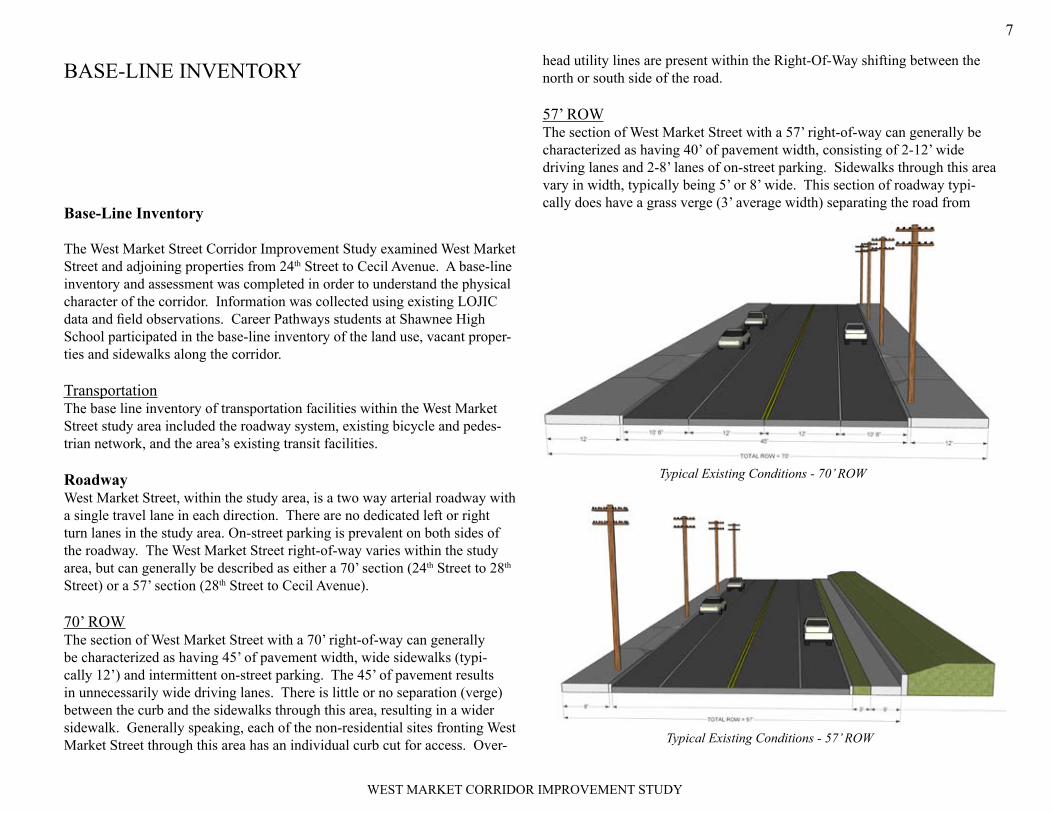
head utility lines are present within the Right-Of-Way shifting between the north or south side of the road.
57’ ROWThe section of West Market Street with a 57’ right-of-way can generally be characterized as having 40’ of pavement width, consisting of 2-12’ wide driving lanes and 2-8’ lanes of on-street parking. Sidewalks through this area vary in width, typically being 5’ or 8’ wide. This section of roadway typi-cally does have a grass verge (3’ average width) separating the road from
Base-Line Inventory
The West Market Street Corridor Improvement Study examined West Market Street and adjoining properties from 24th Street to Cecil Avenue. A base-line inventory and assessment was completed in order to understand the physical character of the corridor. Information was collected using existing LOJIC data and field observations. Career Pathways students at Shawnee High School participated in the base-line inventory of the land use, vacant proper-ties and sidewalks along the corridor.
TransportationThe base line inventory of transportation facilities within the West Market Street study area included the roadway system, existing bicycle and pedes-trian network, and the area’s existing transit facilities.
RoadwayWest Market Street, within the study area, is a two way arterial roadway with a single travel lane in each direction. There are no dedicated left or right turn lanes in the study area. On-street parking is prevalent on both sides of the roadway. The West Market Street right-of-way varies within the study area, but can generally be described as either a 70’ section (24th Street to 28th Street) or a 57’ section (28th Street to Cecil Avenue).
70’ ROWThe section of West Market Street with a 70’ right-of-way can generally be characterized as having 45’ of pavement width, wide sidewalks (typi-cally 12’) and intermittent on-street parking. The 45’ of pavement results in unnecessarily wide driving lanes. There is little or no separation (verge) between the curb and the sidewalks through this area, resulting in a wider sidewalk. Generally speaking, each of the non-residential sites fronting West Market Street through this area has an individual curb cut for access. Over-
BASE-LINE INVENTORY
Typical Existing Conditions - 70’ ROW
Typical Existing Conditions - 57’ ROW

WEST MARKET CORRIDOR IMPROVEMENT STUDY
8
the sidewalk. Overhead utility lines are also present in this section, shifting between the north or south side of the road.
Bicycle and Pedestrian NetworkExisting bicycle facilities within the study area consist of signed bicycle routes. By Kentucky Statutes, cyclists are considered vehicles and allowed use of the road with a few exceptions such as interstate highways. Bicycle routes are roadways where conditions for cyclists are generally more fa-vorable and are signed to provide cyclists direction and remind motorists they are sharing the pavement. The existing signed north/south routes are 25th Street, 29th Street, and 38th Street/Amy Street. The east/west routes are Rowan Street and Cedar Street (Figure 2).
There are existing sidewalks along all of West Market Street within the study area as well as most of the north/south connecting streets. Many sections of these sidewalks, however, are in various stages of disrepair. In several areas the condition of the existing sidewalk, makes them impassible.
FIGURE 2

WEST MARKET CORRIDOR IMPROVEMENT STUDY
9
Transit FacilitiesThe West Market Street study area is presently served by two Transit Author-ity of River City routes. Route 15, “Market Street”, runs along Market Street with regular stops throughout the study area. Route 12, “12th Street”, travels from the Portland neighborhood south to the Parkhill neighborhood, running along West Market Street between 30th and 34th Streets. Transit shelters in place today are limited within the study area (Figure 3).
Land Use/ZoningExisting land use patterns along the corridor were examined to understand both the mix of uses currently present as well as their geographic distribu-tion. The existing land use inventory was completed using information from the LOJIC database that was field-checked by the Shawnee High School students.
The study area can be characterized as mixed-use, containing a broad va-riety of land uses (Figure 4). Residential is by far the most prevalent land use representing over 37% of the study area. 34.6% of the residential land
FIGURE 3

WEST MARKET CORRIDOR IMPROVEMENT STUDY
10
use area is single family and 2.6% is multi-family. Industrial represents the second largest corridor land use at 23.3%, although much of this use is made up by the National Tobacco site. There are a significant number of public or semi-public uses along the corridor including uses as churches, schools and clinics. Public and semi-public sites represent 17.4% of the corridors land use. General commercial and office uses represent 14.7% of the land uses along the corridor. Vacant or undeveloped land (including the I-265 Right-Of-Way) makes up 7.4% of the corridor. There is no park or open space land within the study area boundary (Figure 4).
ZoningProperties within the study area immediately adjoining West Market Street fall into one of four general zoning classes—Residential, Commercial, Office, or Industrial (Figure 5). Within the Residential classification are 3 zoning districts—R-5, R-6, R-7—each of which are considered multi-family zones representing progressively higher densities. Within the Commercial classification are two zoning districts—C1, and C-2, with the latter allowing for a wider range of uses that include those of a higher intensity. The Office
FIGURE 4

WEST MARKET CORRIDOR IMPROVEMENT STUDY
11
and Industrial classifications each include one zoning district—OR-2 and EZ-1, respectively.
Past DevelopmentA review of past zoning activity within the West Market Corridor study area was completed to provide some insight into the community’s growth and development trends. 8 rezoning requests have occurred within the study area since 1974, when records were begun. The vast majority of these requests were for commercial zoning from multi-family residential. There have also been 13 cases in the study area for the Board of Zoning Adjustment (BOZA). These cases consisted of variance requests (9), Conditional Use Permit re-quests (3), and Appeals (2) (Figure 6).
Most of the variance requests were made prior to adoption of the newer Land Development Code, which included standards that recognized the differ-ences between urban and suburban development patterns. The variances were requests to reduce front yard requirements, which previously would have set buildings along West Market back from the street. The Conditional Use
FIGURE 5

WEST MARKET CORRIDOR IMPROVEMENT STUDY
12
Permit requests were to allow for off-street parking. At the time the base line inventory was completed, there were 2 cases pending before BOZA, a landscape waiver and another variance.
Large Land OwnersProperty ownership was also analyzed throughout the study area to any indi-viduals or entities with significant land holdings. This was done to identify and draw into the study process important area “stakeholders” that might also play a critical role in the implementation of any corridor improvements. Property Valuation Administration data was reviewed and analyzed to iden-tify individuals/entities that owned 5 Parcels or more or that owned parcels 0.5 acres in size or larger (Figure 7).
InfrastructureThe West Market Street study area corridor is adequately served by all major utilities. Like most of urban Louisville, stormwater and sanitary sewer ser-vice is met through a combined sewer system. Electric and telephone service is provided via overhead lines that are located immediately adjacent to the roadway.
FIGURE 6

WEST MARKET CORRIDOR IMPROVEMENT STUDY
13
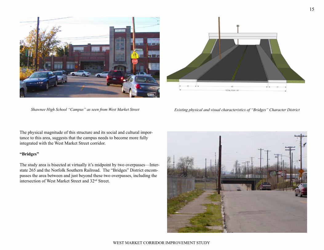
Urban DesignWest Market Street’s historical development patterns and existing land uses have resulted in a collection of distinct “character districts” that begin to define the corridor. There are four basic “character districts” that have been identified within the study area, named for their predominant land use or form—Commercial, Residential, Campus, and Bridges (Figure 8).
Commercial
There are four Commercial Districts along the corridor that make up the largest concentration of existing retail uses. These Commercial Districts or “neighborhood centers” can generally be defined as: - 24th to 28th Street - The intersection of 30th and Market - The intersection of 34th and Market - The intersection of Amy and Market
FIGURE 7

WEST MARKET CORRIDOR IMPROVEMENT STUDY
14
Residential
There are three Residential Districts within the study area located as follows: - 28th to 30th Street - 34th to 38th Street - 41st to Cecil Avenue
Campus
The Campus District is defined by the “campus” of Shawnee High School and includes the area from 39th Street west to 41st Street. Shawnee High School is the largest facility in the Jefferson County School system. The building frontage on West Market Street begins just east of 41st Street and spans more than a city block in length. However, the “entrance” to the school is located off of 41st Street and there is a visual and functional discon-nect between the school and its relationship to West Market Street.
The school is about to undergo a major transformation, converting to a K through 12 facility beginning in the fall of 2010 when it will become The Academy at Shawnee.
French Plaza, off of Amy Avenue, is representative of existing uses in a “Commerical District”
Examples of single family resi-dents that can be found along West Market in one of the “Residential Districts”
FIGURE 8
Commercial District
Residential District
Bridges District
Campus District
WEST MARKET CORRIDOR IMPROVEMENT STUDY
15
The physical magnitude of this structure and its social and cultural impor-tance to this area, suggests that the campus needs to become more fully integrated with the West Market Street corridor.
“Bridges”
The study area is bisected at virtually it’s midpoint by two overpasses—Inter-state 265 and the Norfolk Southern Railroad. The “Bridges” District encom-passes the area between and just beyond these two overpasses, including the intersection of West Market Street and 32nd Street.
Existing physical and visual characteristics of “Bridges” Character DistrictShawnee High School “Campus” as seen from West Market Street

WEST MARKET CORRIDOR IMPROVEMENT STUDY
16
MARKET ANALYSIS
A Planning level market analysis was completed for the West Market Street Corridor study area as a tool to help assist in prioritizing improvements based on potential opportunities for future development and redevelopment along the corridor. To complete this analysis, Gresham, Smith and Partners relied heavily on several recent market studies completed for larger geographic areas that included the West Market Street Corridor study area to understand the market potential for retail development as well as the nature of that devel-opment. GSP also inventoried vacant structures and undeveloped land within the study area and assessed the attractiveness of these sites for development based on criteria of land area, zoning, and access/visibility.
Existing Studies Review
West Louisville Competitive Assessment and Strategy ProjectThe West Louisville Competitive Assessment and Strategy Project was an economic initiative based on “a thorough analysis of the regional and inner city business base and existing and potential market opportunities.” The project was prepared by the Initiative for a Competitive Inner City (ICIC) in partnership with the City of Louisville and was completed in November, 2001. The study area consisted of the four zip codes immediately west of downtown Louisville—40203, 40210, 40211, and 40212.
The initiative had four primary objectives: increase the competitiveness of West Louisville as a business location; stimulate growth of existing West Louisville companies; increase jobs, income, and wealth opportunities for West Louisville residents, and; add to the growth and vitality of the regional economy. The study identified two competitive advantages of the West Lou-isville market—strategic location (access to transportation infrastructure and access to customers), and availability of a workforce. Disadvantages noted
in the study included negative perceptions related to crime and an “unfriend-ly business environment”, actual crime, lack of available land for building and expansion, and an under-skilled labor force.
The researchers focused on industry clusters believed to offer the most promise for the West Louisville area and developed strategies for three—automotive, transportation and logistics, and medical devices and health service within life sciences. Strategies were also developed to help improve the area’s business environment, focusing on land assembly, business de-velopment services, and improving the area’s image and reputation. A West Louisville Economic Alliance, made up of area stakeholders and industry cluster representatives, was identified as the catalyst for implementing the recommended strategies.
Louisville/Jefferson County Metro Retail Market StudyIn April of 2008, Louisville Metro’s Economic Development Department (EDD) commissioned the Louisville/Jefferson County Metro Retail Market Study (MRMS). The study, prepared by Strategy 5, LLC examined future retail market potential based on the relationship between household expenditure levels and corresponding retail sales estimates. According to the MRMS, an “opportunity gap” or potential for retail growth exists for a particular geographic area where ex-penditure levels exceed sales. When sales exceed expendi-ture levels an “opportunity surplus” is said to exist.
Louisville Metro was divided into five zones by the Eco-nomic Development Depart-ment for the purpose of the MRMS—Dixie, Central, Bardstown, Northeast, and Downtown. The trend analysis and market potential analysis contained within the MRMS was organized around these five zones. West Market
Figure 9

WEST MARKET CORRIDOR IMPROVEMENT STUDY
17
Street, and thus the smaller area of Corridor Improvement Study, fall within the northern third of the Dixie Zone (Figure 9). The MRMS stated “the most significant retail opportunities (demand gaps) are evident in the northern sec-tion of the Dixie Zone, in the Portland and West Louisville areas.”
Several recommendations that came out of the MRMS are relevant to the West Market Street Corridor Improvement Study area, including the follow-ing:
Reactivation of underutilized or abandoned properties and re-tenanting 1. of vacant space as “the top priority.”
Infill development opportunities in areas showing significant retail gaps 2. should be identified and ranked according to their development potential us-ing the following criteria: market support, public support, availability and suitability of land (access, visibility, parking, etc.), appropriate zoning.
EDD should closely monitor impact of new retail development on older 3. shopping centers/stores. (Introduction of a new big box and its net effect on the marketplace—existing retailers).
Louisville Metro Neighborhood Market Drill-DownThe Louisville Metro Neighborhood Market Drill-Down (NMDD) study was completed in August of 2008. According to the NMDD, a common indica-tor for national retailers when evaluating future market loca-tions is to review credit card usage for spending trends. In many urban neighborhoods, like those surrounding the West Mar-ket Corridor study area, “a large or even dominant share of the goods and services purchased are purchased with cash”, often resulting in these neighborhoods being underserved. The NMDD, completed by Social Compact, Incorporated, was commissioned by the EDD to understand more fully the potential for retail sales in neighborhood areas like these.
One of the overarching findings of the study was that neighborhood markets are larger (higher population) and have higher average incomes than would be estimated through traditional methods.
The NMDD, which focused predominantly on west Louisville, divided the study area into 10 “neighborhoods”. The West Market Corridor Study boundaries fall within two of those “neighborhoods”—Dixie NE and Dixie NW (Figure 10).
The following represents a summary of the market conditions and potential for retail development in these two areas:
Dixie NEMarket size – 14.8% higher than traditional estimates (59,974) with a popula-tion per acre of 6.5. Population is decreasing however.
Market Strength - $35,933 (average household income) and $25,429 (median household income). Aggregate income per acre is $92,235 or 8 times the MSA. % change in adjusted gross income however is -6% (’98-’05).
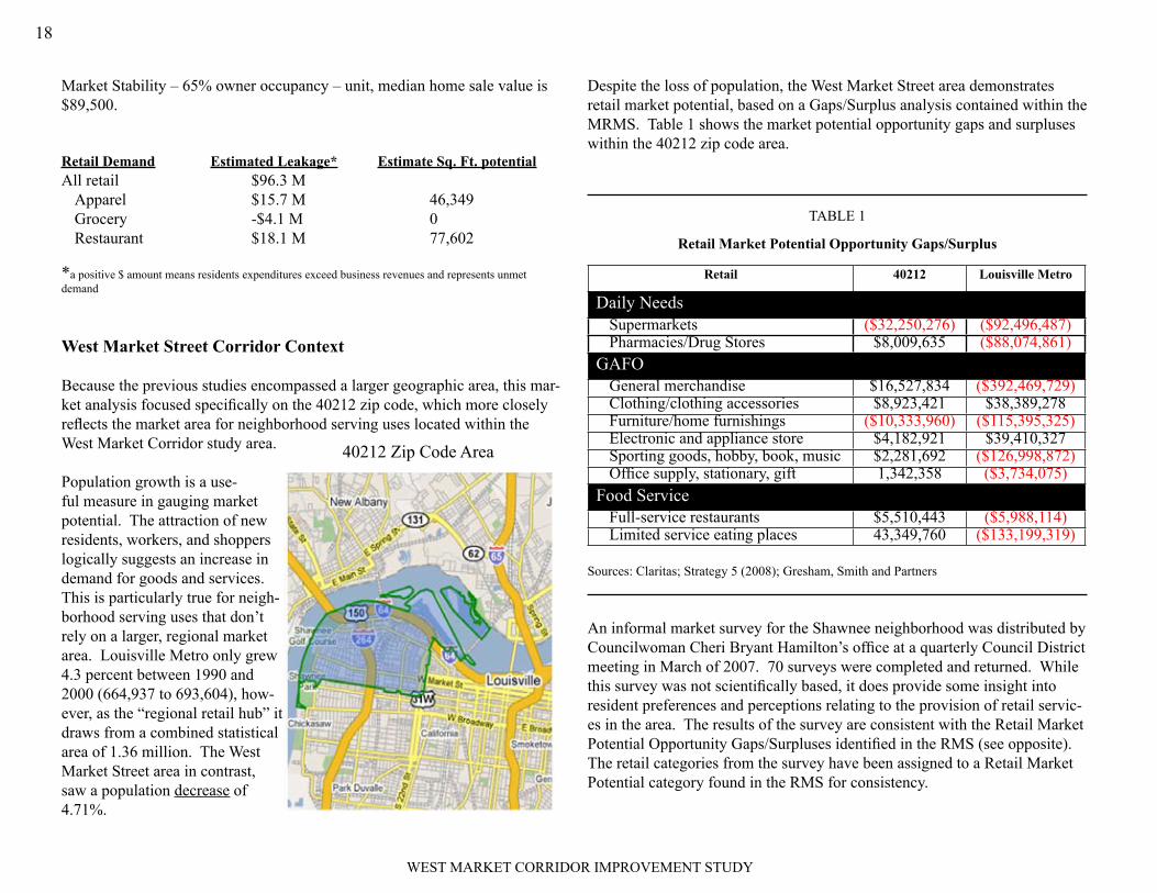
Market Stability – 48% owner occupancy – unit, median home sale value is $89,500.
Retail Demand Estimated Leakage* Estimate Sq. Ft. potentialAll retail $138.2 M
Apparel $25.4 M 74,908Grocery $10.8 M 30,718Restaurant $7.2 M 30,718
* a positive $ amount means residents expenditures exceed business revenues and represents unmet
demand
Dixie NWMarket size – 14.2% higher than traditional estimates (30,711) with a popula-tion per acre of 6.5. Population is decreasing however.
Market Strength - $44,693 (average household income) and $32,694 (median household income). Aggregate income per acre is $68,648 or 5.9 times the MSA. % change in adjusted gross income however is -4% (’98-’05).Figure 10
WEST MARKET CORRIDOR IMPROVEMENT STUDY
18
Market Stability – 65% owner occupancy – unit, median home sale value is $89,500.
Retail Demand Estimated Leakage* Estimate Sq. Ft. potentialAll retail $96.3 M
Apparel $15.7 M 46,349Grocery -$4.1 M 0Restaurant $18.1 M 77,602
*a positive $ amount means residents expenditures exceed business revenues and represents unmet demand
West Market Street Corridor Context
Because the previous studies encompassed a larger geographic area, this mar-ket analysis focused specifically on the 40212 zip code, which more closely reflects the market area for neighborhood serving uses located within the West Market Corridor study area.
Population growth is a use-ful measure in gauging market potential. The attraction of new residents, workers, and shoppers logically suggests an increase in demand for goods and services. This is particularly true for neigh-borhood serving uses that don’t rely on a larger, regional market area. Louisville Metro only grew 4.3 percent between 1990 and 2000 (664,937 to 693,604), how-ever, as the “regional retail hub” it draws from a combined statistical area of 1.36 million. The West Market Street area in contrast, saw a population decrease of 4.71%.
Despite the loss of population, the West Market Street area demonstrates retail market potential, based on a Gaps/Surplus analysis contained within the MRMS. Table 1 shows the market potential opportunity gaps and surpluses within the 40212 zip code area.
TABLE 1
Retail Market Potential Opportunity Gaps/Surplus
Retail 40212 Louisville Metro
Daily NeedsSupermarkets ($32,250,276) ($92,496,487)Pharmacies/Drug Stores $8,009,635 ($88,074,861)
GAFOGeneral merchandise $16,527,834 ($392,469,729)Clothing/clothing accessories $8,923,421 $38,389,278Furniture/home furnishings ($10,333,960) ($115,395,325)Electronic and appliance store $4,182,921 $39,410,327Sporting goods, hobby, book, music $2,281,692 ($126,998,872)Office supply, stationary, gift 1,342,358 ($3,734,075)
Food ServiceFull-service restaurants $5,510,443 ($5,988,114)Limited service eating places 43,349,760 ($133,199,319)
Sources: Claritas; Strategy 5 (2008); Gresham, Smith and Partners
An informal market survey for the Shawnee neighborhood was distributed by Councilwoman Cheri Bryant Hamilton’s office at a quarterly Council District meeting in March of 2007. 70 surveys were completed and returned. While this survey was not scientifically based, it does provide some insight into resident preferences and perceptions relating to the provision of retail servic-es in the area. The results of the survey are consistent with the Retail Market Potential Opportunity Gaps/Surpluses identified in the RMS (see opposite). The retail categories from the survey have been assigned to a Retail Market Potential category found in the RMS for consistency.
40212 Zip Code Area
WEST MARKET CORRIDOR IMPROVEMENT STUDY
19
West Market Survey Responses(Top 25 Desired Businesses)
Retail Market Potential Categories
Family restaurant Full-service restaurantsBookstore Sporting goods, hobby,
book, musicSenior business/medical supply/home health
General merchandise
Movie theater EntertainmentClothing/shoe store Clothing/clothing accessoriesCoffee shop Limited service eating placesGarden supply/hardware store General merchandisePrint/copy business General merchandiseRoller rink EntertainmentDonut/sandwich shop Limited service eating placesPhysician/Dentist ProfessionalOffice supply Office supply, stationary, giftDry cleaner/laundry General merchandiseDrugstore Pharmacies/Drug StoresArt & craft/hobby Sporting goods, hobby, book,
musicDance studio ProfessionalCar wash General merchandiseGrocery store SupermarketsBank ProfessionalArt/photography studio ProfessionalVeterinarian/Pet supplies General merchandiseAuto supply General merchandiseMusic/video Sporting goods, hobby, book,
musicBarber/beauty shop ProfessionalDay care Professional
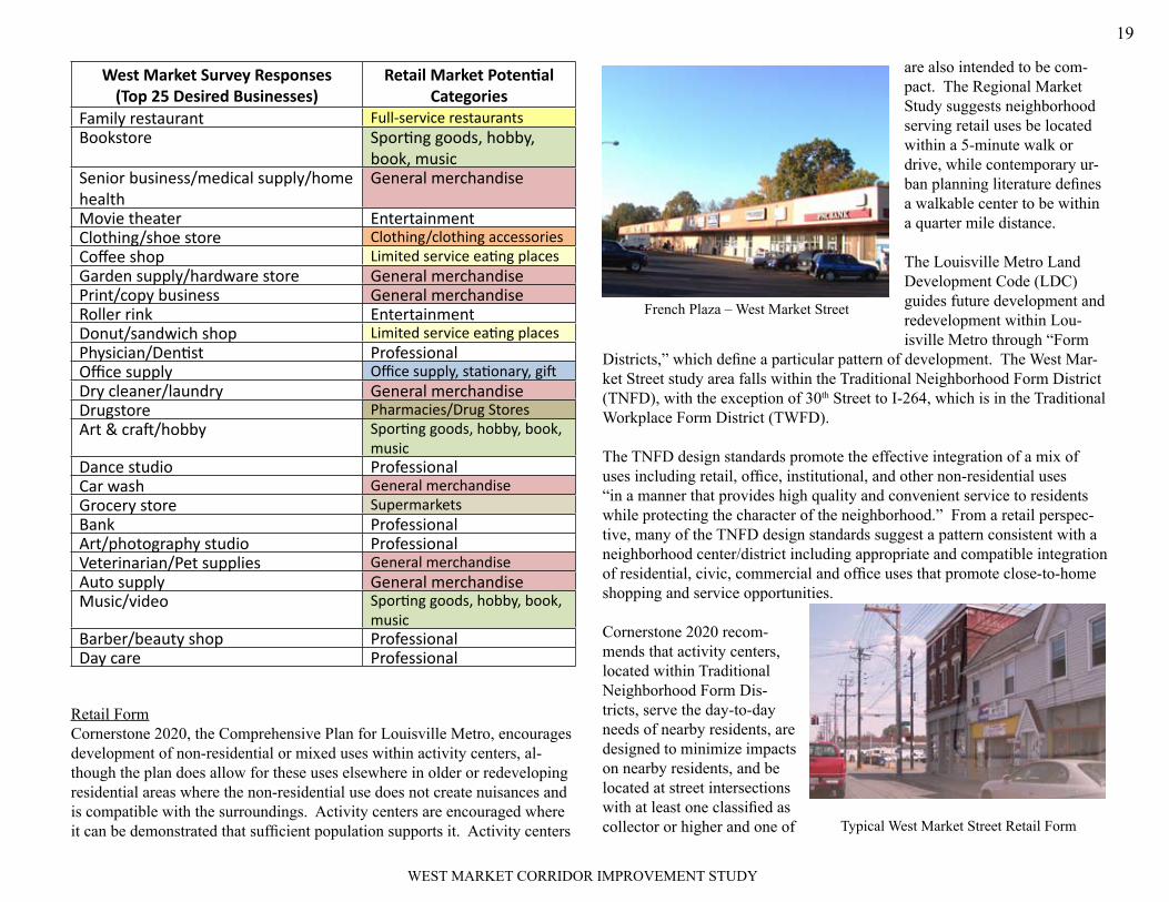
Retail FormCornerstone 2020, the Comprehensive Plan for Louisville Metro, encourages development of non-residential or mixed uses within activity centers, al-though the plan does allow for these uses elsewhere in older or redeveloping residential areas where the non-residential use does not create nuisances and is compatible with the surroundings. Activity centers are encouraged where it can be demonstrated that sufficient population supports it. Activity centers
are also intended to be com-pact. The Regional Market Study suggests neighborhood serving retail uses be located within a 5-minute walk or drive, while contemporary ur-ban planning literature defines a walkable center to be within a quarter mile distance.
The Louisville Metro Land Development Code (LDC) guides future development and redevelopment within Lou-isville Metro through “Form
Districts,” which define a particular pattern of development. The West Mar-ket Street study area falls within the Traditional Neighborhood Form District (TNFD), with the exception of 30th Street to I-264, which is in the Traditional Workplace Form District (TWFD).
The TNFD design standards promote the effective integration of a mix of uses including retail, office, institutional, and other non-residential uses “in a manner that provides high quality and convenient service to residents while protecting the character of the neighborhood.” From a retail perspec-tive, many of the TNFD design standards suggest a pattern consistent with a neighborhood center/district including appropriate and compatible integration of residential, civic, commercial and office uses that promote close-to-home shopping and service opportunities.
Cornerstone 2020 recom-mends that activity centers, located within Traditional Neighborhood Form Dis-tricts, serve the day-to-day needs of nearby residents, are designed to minimize impacts on nearby residents, and be located at street intersections with at least one classified as collector or higher and one of
French Plaza – West Market Street
Typical West Market Street Retail Form

WEST MARKET CORRIDOR IMPROVEMENT STUDY
20
the corners containing established non-residential uses.
The Traditional Workplace Form District (TWFD) has been applied to older, established areas containing primarily small-to-medium scale industrial and employment uses. Many of these uses, like the National Tobacco site on West Market, were historically integrated with or adjacent to residential uses within traditional neighborhoods. The TWFD design standards encourage adaptive reuse and investment in a manner compatible with adjacent uses. Both West Market Form Districts strive to retain “traditional” development patterns such as connected street grids and buildings set closer to the road-ways.
Conclusions
The market research that has been recently completed for West Louisville indicates that there is real opportunity to support retail growth and develop-ment within the West Market Street Corridor study area. Retail development is traditionally thought of in two general ways—as part of a shopping center or as free standing. In an urban context, shopping centers may also take the form of “shopping districts,” a collection of free-standing, single retail tenant buildings. This represents the predominant form of retail within the West Market Street study area.
Shopping centers, as classified by the Urban Land Institute by size and tenant make up, include Neighborhood, Community, Regional, and Super Regional (Appendix). Based on the findings of the Retail Market Study, the Drill-Down Study, and even the Shawnee Market Survey, the likely retail opportu-
nities for the West Market Street Corridor would be consistent with uses found in a Neighbor-hood Center.
The Urban Land Institute (ULI) has established guidelines for each of the various shopping center types as a tool to assist in making broad-based, policy and planning decisions for develop-ment.
Based on ULI’s guidelines and Strategy 5’s analysis within the context of Louisville Metro, the following were identified as reasonable minimum stan-dards for a Neighborhood Center to ensure the necessary market support for operational feasibility.
Min. Population Trade Area Radius Drive Time3,000-4,000 3 miles 5-10 minutes
Source: ULI; Strategy 5
Development/Redevelopment Potential
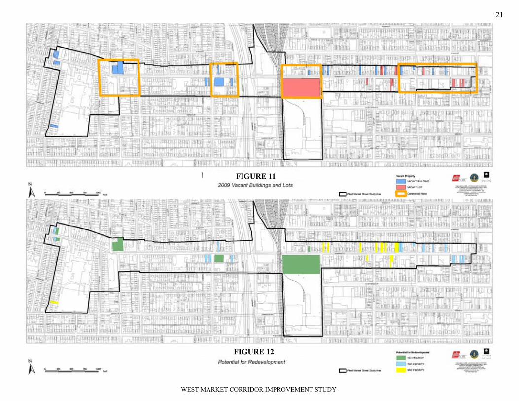
GS&P evaluated the West Market Street Corridor study area to identify those sites along the corridor with high redevelopment potential. Many fac-tors come into play in siting a new retail facility and these factors will vary depending on the type of retail. The MRMS suggests that “nothing signals a neighborhood’s decline like vacant properties.” Vacant lots and buildings were therefore identified as the highest candidates for future redevelopment (Figure 12).
Access and/or traffic, visibility and/or “curb appeal,” physical space needs, existing zoning, and presence of other retail (competition or companion) are additional factors that should be considered in siting future retail. GS&P evaluated each of the vacant building and lot sites using these criteria and grouped these properties into three categories—high, medium, low—based on their overall redevelopment potential (Figure 12). This evaluation as-sumes that all needed utilities are available and that no other constraints (environmental, ownership, etc.) are present.
National Toboacco’s vacant West Market frontage is a prime redevelopment site
Vacant sites, like this gas station on 34th, are high priorities for redevelopment
WEST MARKET CORRIDOR IMPROVEMENT STUDY
21
FIGURE 11
FIGURE X FIGURE 12

WEST MARKET CORRIDOR IMPROVEMENT STUDY
22
Using information compiled from the base line inventory, each of the four Character Districts was analyzed to understand its unique characteristics and what design response would be appropriate in the form of physical improve-ments.
Commercial Districts
While the uses within the four identified Commercial Districts may vary, there are several common characteristics of these areas that set them apart. In general, these areas are defined by the intersection of West Market with a major north/south corridor. Two-and three-story buildings often dominate the corners, with buildings generally set close to the road.
Design ResponseBased on analysis of the inventory information, stakeholder interviews, and recognizing the primary uses associated with this district, the recommended design responses are:
Wider sidewalks to accommodate increased pedestrian vol-•umes and to allow ancillary commerical activity (sidewalk sales, outdoor dining, etc.) More formal, lower profile landscape treatment to maintain •storefront visibility, while creating a high level of visual interest. A common palette of plant materials will help to establish a unified identity for each commercial district.Signage that is designed and placed not only to identify the •businesses for potential customers, but to contribute to an attractive, inviting sense of place. Iconic elements unique to the West Market Street corridor would be most prevelant in the commerical districts.
Use of street furnishings, including benches, trash recep-•ticles, and planters to make pedestrians feel comfortable and welcome and contribute to district’s visual character.Reinforce commercial development by encouraging new •businesses to locate within the commerical districts rather than elsewhere on West Market Street, to help establish a “critical mass” of retail uses that would attract shoppers.Reinforce the urban pattern by continuing to maintain •storefronts set close to the street. Identify opportunities for shared parking facilities to overcome the limited parking available on-street in these districts.
Residential
The most important characteristic of the three Residential Districts identified in the study area is they are predominately residential today. These districts tend to have a lower profile than the Commercial Districts, with building heights of one and two stories. Many of the existing structures in Residential Districts are set back further from the road, creating semi-private and private zones within the front yard setbacks. All of the lot widths within the corridor
ALTERNATIVES
Typical residential structures within one of the Residential Character Districts

WEST MARKET CORRIDOR IMPROVEMENT STUDY
23
tend to be narrow in keeping with historic urban lot patterns. In the Residen-tial District, however, because there is typically one structure on a single lot, the narrow width is generally more prevalent.
Design ResponseBased on analysis of the inventory information, stakeholder interviews, and recognizing the primary uses associated with this district, the recommended design responses are:
Encourage a relationship to street and neighbors by improv-•ing sidewalks and making the walking experience more ap-pealing. Narrower sidewalks (5’-7’) reflect a lower volume of traffic and allow for more green space in these districts. Limit front yard structures to low fences/retaining walls to •maintain the visual connection between the public, semi-pri-vate, and private areas between the street and the residences. Use street trees to enhance the pedestrian experience and •create a unique feel and identity for the residential districts.
Campus
The Campus District’s characteristics as they exist today can be described as a cross between the characteristics of Commercial and Residential Districts. Within the Right-Of-Way, the Campus District resembles the Residential District with 5’ sidewalks and a 3’ grass verge. The character of this District however, beyond the Right-Of-Way much more closely resembles that of the area’s Commercial Districts. The north side of West Market Street contains a mix of retail, residential and institutional uses, with buildings set close to the street. On the south side is Shawnee High School, which has a scale and mass that is unique to the corridor.
Design ResponseBased on analysis of the inventory information, stakeholder interviews, and recognizing the primary uses associated with this district, the recommended design responses are:
Become a western “Gateway” of the West Market Street •Corridor community using a grander landscape treatment.Create a stronger identity for school and its relationship to •West Market Street.Acknowledge high pedestrian traffic through improvements •to the sidewalk and plaza entrances.
“Bridges”
Market Street is depressed below normal grade through this area in order to traverse under these bridges. Although the pavement width of the street re-mains unchanged through this area, there is no on-street parking so the drive lanes become wider. The roadway is bounded by retaining walls that effec-tively separate Market Street from the adjoining properties. As a result this area is visually harsh and uninviting to the pedestrian, particularly immedi-ately under the bridge structures where lighting is poor or nonexistent.
Design ResponseBased on analysis of the inventory information, stakeholder interviews, and recognizing the primary uses associated with this district, the recommended design responses are:
Connect the commercial districts east and west of the bridges •to create a stronger, more vibrant, retail center for this sec-tion of the corridor.Celebrate the district’s location as the physical link between •the Shawnee, Russell, and Portland neighborhoods by creat-ing a community-wide gathering space.Transform the negative experience created by the harsh, un-•inviting existing environment into a positive experience.
The Campus District is defined by the presence of Shawnee High School

WEST MARKET CORRIDOR IMPROVEMENT STUDY
24
Alternatives
Based on the inventory and analysis, alternatives for physical improvements to the West Market Street Right-Of-Way were developed and evaluated for each of the four Character Districts. The first alternative focused on im-provements beyond the back of the existing curb, in order to leave the exist-ing roadway intact. The second alternative examined limited modifications to the roadway in addition to the improvements beyond the curb line. A third alternative considered the elimination of the on-street parking to reclaim that pavement area for other improvements.
57’ ROW SECTION - ALTERNATIVE 1
Alternative 1 would maintain or reduce sidewalks to 5’ in width with a 3’ verge. The verge would be lawn through the residential districts and a paver or stamped concrete through the non-residential districts.
Small street trees and pedestrian scale lighting would be provided within the Right-Of-Way. Larger trees would be encouraged outside the Right-Of-Way.
Iconic elements such as banners added to the the light standards, would be introduced.
WEST MARKET CORRIDOR IMPROVEMENT STUDY
25
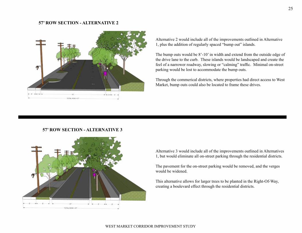
Alternative 2 would include all of the improvements outlined in Alternative 1, plus the addition of regularly spaced “bump out” islands.
The bump outs would be 8’-10’ in width and extend from the outside edge of the drive lane to the curb. These islands would be landscaped and create the feel of a narrower roadway, slowing or “calming” traffic. Minimal on-street parking would be lost to accommodate the bump outs.
Through the commerical districts, where properties had direct access to West Market, bump outs could also be located to frame these drives.
Alternative 3 would include all of the improvements outlined in Alternatives 1, but would eliminate all on-street parking through the residential districts.
The pavement for the on-street parking would be removed, and the verges would be widened.
This alternative allows for larger trees to be planted in the Right-Of-Way, creating a boulevard effect through the residential districts.
57’ ROW SECTION - ALTERNATIVE 3
57’ ROW SECTION - ALTERNATIVE 2

WEST MARKET CORRIDOR IMPROVEMENT STUDY
26
Alternative 1 would reduce sidewalks to 7’ in width and allow for a 5’ verge. The verge would be lawn through the residential districts and a paver or stamped concrete through the non-residential districts.
Small street trees and pedestrian scale lighting would be provided within the Right-Of-Way. Larger trees would be encouraged outside the Right-Of-Way.
Iconic elements, such as banners added to the the light standards, would be introduced.
Alternative 2 would include all of the improvements outlined in Alternative 1, plus the addition of regularly spaced “bump out” islands.
The bump outs would be 8’-10’ in width and extend from the outside edge of the drive lane to the curb. These islands would be landscaped and create the feel of a narrower roadway, slowing or “calming” traffic. Minimal on-street parking would be lost to accommodate the bump outs.
Through the commerical districts, where properties had direct access to West Market, bump outs could also be located to frame these drives.
70’ ROW SECTION - ALTERNATIVE 1
70’ ROW SECTION - ALTERNATIVE 2

WEST MARKET CORRIDOR IMPROVEMENT STUDY
27
Alternative 3 would include all of the improvements outlined in Alterna-tives 1, but would narrow the existing drive lanes to 12’, reducing the overall pavement width.
The excess pavement would be removed, and the verges would be widened.
This alternative allows for larger trees to be planted in the Right-Of-Way through the residential districts on the side of West Market where overhead lines didn’t exist, creating a boulevard effect.
Alternative 1 would narrow the existing drive lanes to 12’, reducing the over-all pavement width.
The excess pavement would be removed, and the verges would be widened to 8’ with 10’ wide sidewalks to accommodate the anticipated volumes of pedestrian traffic.
Small street trees and pedestrian scale lighting would be provided within the Right-Of-Way along with iconic elements such as banners.
70’ ROW SECTION - ALTERNATIVE 3
BRIDGES DISTRICT - ALTERNATIVE 1

WEST MARKET CORRIDOR IMPROVEMENT STUDY
28
Alternative 2 would reduce the existing pavement and introduce a landscaped center median. Appropriately spaced breaks in the median would allow for access in the event of a drive lane being blocked.
The median would be landscaped between the bridge overpasses to create a unique character for this district. Under the bridges, the median would be finished with decorative pavers or stamped concrete.
Sidewalks, verge design, and streetscape elements consistent with alternative 1 would be introduced.
Alternative 3 would include all of the improvements identified as part of alternative 2, plus a mid-block crossing for pedestrians.
The crossing would be constructed of decorative pavers or stamped concrete to match the verge treatment. The median would provide a refuge for pedes-trians to navigate traffic from one direction at a time.
This alternative also demonstrates the concept of feastival space between the bridges to promote public gatherings like a Farmer’s Markets or special neighborhood events.
BRIDGES DISTRICT - ALTERNATIVE 2
BRIDGES DISTRICT - ALTERNATIVE 3

WEST MARKET CORRIDOR IMPROVEMENT STUDY
29
Alternative 2 recommends improvements outside of the public Right-Of-Way. These improvements include a dedicated pick up/drop off lane con-structed in front of Shawnee High School.
This alternative also includes using an alternative pavement (pavers or stamped concrete) for the sidewalk in front of the school as well as improv-ing both entrance plazas to the school.
Improved signage for the school would also be introduced.
Alternative 1 would maintain 5’sidewalks on the north side of West Mar-ket Street and create 12’ sidewalks on the south side of the street in front of Shawnee High School. Each side would have a 3’ verge. The verge would be lawn through the residential sections and a paver or stamped concrete through the non-residential sections and in front of the school.
The intersection of West Market and 38th Street would be improved with pavers or stamped concrete to emphasize the pedestrian crossings at this location.
Small street trees and pedestrian scale lighting would be provided within the Right-Of-Way. Iconic elements would also be introduced.
Existing physical and visual characteristics of Campus Character District
CAMPUS DISTRICT - ALTERNATIVE 1
CAMPUS DISTRICT - ALTERNATIVE 2
WEST MARKET CORRIDOR IMPROVEMENT STUDY
30
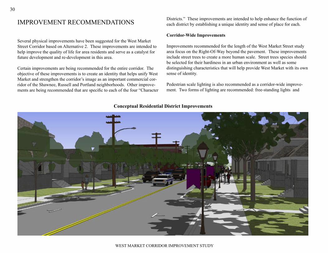
Several physical improvements have been suggested for the West Market Street Corridor based on Alternative 2. These improvements are intended to help improve the quality of life for area residents and serve as a catalyst for future development and re-development in this area.
Certain improvements are being recommended for the entire corridor. The objective of these improvements is to create an identity that helps unify West Market and strengthen the corridor’s image as an important commercial cor-ridor of the Shawnee, Russell and Portland neighborhoods. Other improve-ments are being recommended that are specific to each of the four “Character
Districts.” These improvements are intended to help enhance the function of each district by establishing a unique identity and sense of place for each.
Corridor-Wide Improvements
Improvements recommended for the length of the West Market Street study area focus on the Right-Of-Way beyond the pavement. These improvements include street trees to create a more human scale. Street trees species should be selected for their hardiness in an urban environment as well as some distinguishing characteristics that will help provide West Market with its own sense of identity.
Pedestrian scale lighting is also recommended as a corridor-wide improve-ment. Two forms of lighting are recommended: free-standing lights and
IMPROVEMENT RECOMMENDATIONS
Conceptual Residential District Improvements

WEST MARKET CORRIDOR IMPROVEMENT STUDY
31
those mounted directly to existing utility posts. The light fixture would be identical for both. The specific light fixture should be selected from those readily available through the Louisville Gas and Electric Company to ensure cost-effective installation and maintenance.
Development and installation of iconic elements for the West Market Street corridor are also recommended as a corridor-wide improvement. Creating an icon to symbolize the corridor, either in the form of a logo, image, slogan or similar device, can be used as a unifying element for West Market Street. The corridor icon could be reproduced on items such as banners, bench backs, insets in trash recepticles or similar applications. The West Market Street icon should be recognizable, reproducable in varying forms, and easily read.
Character District Improvements
Character District specific improvements are intended to strengthen and re-inforce the unique qualities, functions, and characteristics that shape each of the four Character Disticts.
ResidentialRecommendations for improvements to the two residential character districts include more frequently spaced street trees, with larger trees located beyond the Right-Of-Way and overhead utility lines. Verges within the residential districts would be lawn. Pedestrian lighting would be spaced to provide an appropriate level of lighting for security on the walks without impacting the light levels at the fronts of the residences themselves. 5’ sidewalks should be free of benches, trash receptacles or other street furnishings. Icon elements,
Conceptual Intersection Improvements - Commercial District
WEST MARKET CORRIDOR IMPROVEMENT STUDY
32
such as banners, would still be present but spaced less frequently than the other 3 districts.
CommercialRecommendations for improvements to the four commerical character dis-tricts include less frequently spaced street trees, placed to maximize visibility of the business frontages. Verges within the commercial districts would be pavers, stamped concrete or a similar treatment, and would extend from the curb to the building facade. Lighting would be spaced for both security and to create a enlivened plaza space. Street furnishings, including benches, trash receptacles, planters, and cafe seating would be present to create a more active space for gathering and pedestrian activity. Iconic elements would be present throughout the district.
BridgesRecommendations for improvements to the bridges character district include a landscaped median dividing east and west traffic lanes. Verges within this district would be lawn, except under the overpasses, where pavers or stamped concrete would be used. Pedestrian lighting would be spaced to provide an appropriate level of lighting for security on the walks with particular empha-sis on providing a well-lit, inviting feel under the bridges themselves. The objective of the bridges district would ultimately be to create a central com-munity space that symbolically and physically joins the three West Market Street neighborhoods. Sidewalks would therefore be wider (7’) to accom-modate larger volumes of pedestrian traffic. Icon elements should be used in this district to reinforce the notion of unity.
Conceptual Campus District Improvements

WEST MARKET CORRIDOR IMPROVEMENT STUDY
33
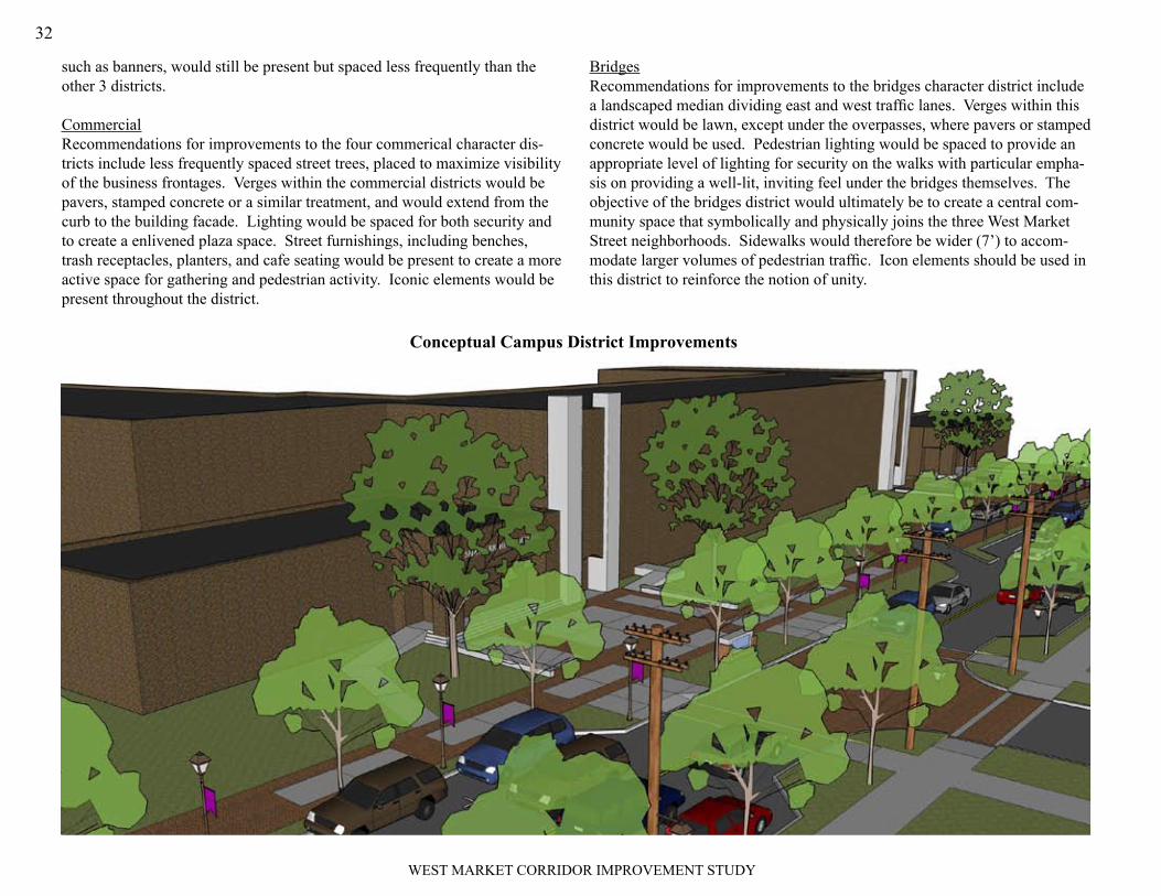
CampusRecommendations for improvements to the campus district include more frequently spaced street trees, with larger trees located on school grounds be-yond the right-of-way and overhead utility lines. Verges withing the campus district would be lawn, except at crossings and entry ways. Improved plaza space would be provided at both school entrances to create a visual sense of arrival. Plazas, with seating and trash receptacles, also would better accom-modate gathering students at the start and close of school. Icon elements, such as banners would be used with improved signage to strengthen the school’s presence along West Market Street.
Upper Left - improved transit stops to accommodate sudent riders
Upper Right - stamped concrete paving pattern at the intersection of West Market and 38th Street provides visual cues for drivers that students cross here
Bottom - a dedicated pick up/drop off lane on the west end of the campus creates a safer environment for students and avoids delays from stopped cars on Market Street.

WEST MARKET CORRIDOR IMPROVEMENT STUDY
34
The success of the West Market Street Corridor Improvement Plan begins with a pratical, achievable imlementation strategy. This strategy includes an understanding of the costs for implementing the recommendations as well as establishing priorities and a general sequencing for the recommendations. This allows the vision for West Market Street to be implemented over time as funds are found, without losing the continuity of the overall vision. Another component of a successful implementation strategy is identifying who or what entity will be responsible for implementing and maintaining the recom-mended improvments.
IMPLEMENTATIONThe table on the opposite page provides “order of magnitude” cost opinions as well as priorities for implementing the West Market Street improvements. Costs have been projected for each improvement both by Character District as well as for the overall corridor. High priority improvements include corri-dor-wide recommendations for sidewalks and street trees. Also identified as high priority are the improvements to the Commerical Districts, which will aid existing businesses at these locations and serve as a catalyst for future public and private investment in the area.
Installation and maintenance are also critical to the long-term success of the proposed improvements. This will require a true partnership between public and private entities. The table below outlines the various entities that would be best positioned to install and to maintain the proposed improvements for the West Market Street corridor. These responsibilities have been broken down by Character District as well as by specific improvement type.
ImprovementSidewalks/Verges Street Trees Roadway Lighting Furnishings
District Install Maintain Install Maintain Install Maintain Install Maintain Install Maintain
Residential Metro Resident Metro or Resident Resident Metro Metro
Metro or Neigh. Assoc.
Metro or Neigh. Assoc.
Metro or Neigh. Assoc.
Neigh. Assoc.
Commercial Metro or Business
Business or Bus. Assoc.
Metro or Business
Business or Bus. Assoc.
Metro MetroMetro or Bus. Assoc.
Metro or Bus. Assoc.
Metro or Bus. Assoc.
Business or Bus. Assoc.
“Bridges” Metro or Business
Business or Bus. Assoc.
Metro or Business
Business or Bus. Assoc.
MetroBusiness or Bus. Assoc.
Metro or Bus. Assoc.
Metro or Bus. Assoc.
Metro or Bus. Assoc.
Business or Bus. Assoc.
Campus (South)Metro and
JCPSJCPS Metro JCPS
Metro and
JCPS
Metro and
JCPS
Metro or JCPS
Metro or JCPS
Metro or JCPS
Metro or JCPS
Campus (North) Metro or Business
Business or Bus. Assoc.
Metro or Business
Business or Bus. Assoc.
Metro MetroMetro or Bus. Assoc.
Metro or Bus. Assoc.
Metro or Bus. Assoc.
Business or Bus. Assoc.

WEST MARKET CORRIDOR IMPROVEMENT STUDY
35

WEST MARKET CORRIDOR IMPROVEMENT STUDY
36
APPENDIX
WEST MARKET CORRIDOR IMPROVEMENT STUDY
corrIdor AdvIsory grouP meetIng mInutes..................................... 37
stAkeholder IntervIew summAry....................................................... 43
ulI retAIl center defInItIons.......................................................... 45
resource mAPs................................................................................... 47

WEST MARKET CORRIDOR IMPROVEMENT STUDY
37
DISCUSSION:
CouncilwomanHamiltonopened themeetingbywelcoming theCor-ridorAdvisoryGrouptothe1stmeetingoftheWestMarketStreetCor-ridorImprovementStudy.TheCouncilwomanstatedthattheprocessbeganwithadecision tostudypossible improvements thatcouldbemadetoWestMarketStreet.ThestudywasfundedbytheLouisvilleMetroCouncilwithmoneyallocated toCouncilDistrict5,andwillbemanagedbytheEconomicDevelopmentDepartment.
Councilwoman Hamilton introduced Gresham, Smith and Partners(GSP),aplanningconsultingfirmselectedtoleadthestudy.
JonHenney,GSPProjectManager,welcomedtheCAGmembersandintroduced theProjectTeam to theCAG. TheCAGmembers intro-ducedthemselvesandstatedwhatorganizationtheyrepresented.(ForalistofattendeesseeParticipantList)
Thepurposeoftheprojectwassummarizedasimprovingthequalityof life forcorridorresidents,businessowners,andusersbyoutliningstrategiestomaximizethebenefitsfrompotentialpublicand/orprivate-ly-financedimprovementsanddevelopmentprojectsinthestudyarea.ThestudyareawasdefinedastheWestMarketStreetcorridor fromeastern22ndStwesttoCecilAve.
FeliciaHarper,GSPProjectPlanner,reviewedthefollowingrolesandresponsibilitiesoftheCAG:1.
Advise and Inform project team of issues, challenges and op-•portunities within the study area.Help engage the larger community in the planning process.•Give advice, critiques and suggestions of recommendations for •the study.Be a CAG member through the duration of the process, over a 5 •month process.There will be 3 CAG meetings that will last 1.5 – 2 hours each.•
Corridor Advisory Group MeetingMEETINGDATE:
December 10, 2008
PARTICIPANTS:
CAGMEMbERS
Rudy Davidson Donna McDonaldCharles Diggs Joe McNealyMarian Dunkerley Steve MillerAnthony French Jewell Smotherman Ruth French Earl StringerFrederick Liggin Brenda White
Councilwoman Hamilton — Metro CouncilSusan Hamilton — Economic Development DepartmentApril Jones — Economic Development DepartmentScott Love — Economic Development DepartmentWeddie Lanier — Economic Development DepartmentJohn Fischer — Economic Development DepartmentJon Henney — Gresham, Smith and PartnersFelicia Harper — Gresham, Smith and Partners

WEST MARKET CORRIDOR IMPROVEMENT STUDY
38Ms. Harper then reviewed the overall planning process that will be used to complete the study, including:2.
Inventory and analysis of land use, infrastructure, transportation •and community design.Preparation of a Corridor Improvement Plan that will include:•
Plans for improving the quality of life, stimulating eco-o nomic development and improving property values.Support existing retail and new retail infrastructure.o
The preparation of a Final Corridor Improvement Plan will be •produced and a public meeting will be conducted for the general public.
A preliminary project schedule was then presented to the CAG mem-bers.
Inventory and analysis data collection will be ongoing through-•out the process.Stakeholder Interviews will be conducted in January and Febru-•ary for key interest groups. CAG meeting # 2 will be held in February.•CAG meeting # 3 will be held in April.•The Draft Plan will be ready for review by April.•The Final Plan will be produced and presented in May.•
Mr. Henney gave a brief presentation on the concept of “Complete Streets” and the components of what makes a “Complete Street”, noting they are designed and operated to enable safe access for all users (pedes-trians, bicyclists, motorists and bus riders) of all ages and abilities. Mr. Henney stated that the complete street concept would be used as a basis for helping to evaluate study recommendations
GSP staff reviewed with the CAG known opportunities and constraints within the study area. Those identified by the consultant team were:
The combined sewer overflow (CSO) reconstruction project and •what it means for redevelopment opportunity in the corridor.Existing commercial nodes along the corridor including -•
French Plaza areao Ace Hardware areao 34o th & Market St.
The commercial district located at 26• th and Market. There are opportunities to expand and strengthen this commercial district.The Shawnee Expressway overpass is a constraint within the •neighborhood, creating a barrier along West Market Street. Railroad overpass, which provides greater opportunity for cer-•tain uses, but also creates a visual/physical barrier splitting the neighborhood.The National Tobacco property, this site is strategically located •and has redevelopment potential.PNC Bank. This bank branch, located in the French Plaza Shop-•ping Center, is an important staple in the community. The clos-ing of the branch could affect the neighborhood and measures should be taken to ensure the future existence of the branch.A strong church and institutional presence, along with a solid •residential base supported by active neighborhood groups.
CAG EXERCISE
The consultant team led the CAG in a mapping exercise to further iden-tify opportunities and constraints along the corridor. The exercise di-vided the corridor into two sections (24th to 28th and 28th to Cecil) for the purpose of reviewing the corridor in greater detail. A summary of the mapping exercise is below.
24th Street to 28th Street Map ReviewThere is a need to enhance rental property •within the corridor. There is an abundance of vacant rental houses along Market Street that have fallen into disrepair over the years. An increase in owner occupied housing would •be a plus to the neighborhood. There should be some sort of incentive and encouragement or home ownership for the residents. There are numerous vacant houses along 24• th

WEST MARKET CORRIDOR IMPROVEMENT STUDY
39
– 28th Street. Majority of these houses are owned by ACE hardware. It was determined that these properties should be rezoned to commercial for future development. 26• th & Market has several vacant buildings that are boarded up and are not in good shape. Market Street between 24• th to 28th could be a good anchor for commercial development along both sides of the street. This could be possible because residential property would be easy to purchase because many are vacant. The block of 28• th Street is a stable residential area. Urban size development is needed along the cor-•ridor. Big box retail would be out of place along the corridor. ACE Hardware should be used for a model for all future development. If residents are displaced from Market Street by re-•development as a commercial corridor, the existing neighborhood could absorb existing residents. CAG community would like to see live/work units •along Market Street to encourage pedestrian activ-ity along West Market Street. There is a dire need for a restaurant district along •the corridor. 24th to 28th Street would be the desired location of this district. CAG would like to see something similar to Bardstown Road of Frankfort Ave. West Market Street from 24• th -26th Street needs a sidewalk assessment to promote the commercial development needed in the community. Many sidewalks are in dire need of replacement and repair. There needs to be a well defined pedestrian area. There is a need for lighting, street trees and street •furniture along West Market Street. Bus stop/shelter location need to be assessed •using LOJIC data to show that every area is be-
ing provided for. There tends to be vandalism to TARC shelters in the area and a solution needs to be determined for shelters upkeep. Façade improvements are needed on commercial •developments along the corridor. These improve-ments would encourage people to frequent the retail stores. CAG members determined the need to expand the •bicycle lanes along the corridor to support alterna-tive transportation modes to relieve traffic conges-tion. There is a need for a crosswalk along 26• th and Market for safe pedestrian access.
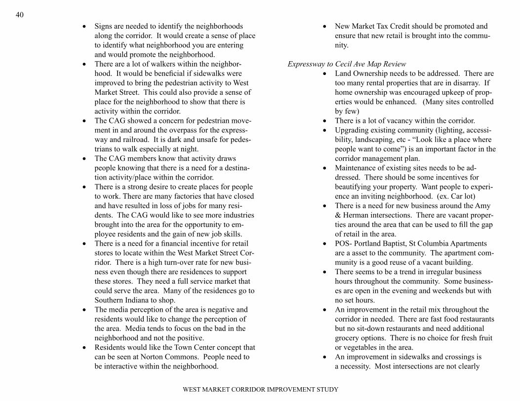
28th Street to Expressway Map ReviewThe vacant land next to National Tobacco should •be included in the redevelopment if any, of the National Tobacco property.The CAG recommended the redevelopment of •National Tobacco should be commercial fronting Market Street. The redevelopment setback should align with existing retail along Market. There should be a redevelopment of the Recall •property adjacent to the railroad. There is a dire need for a Landscaping District or •standards along the Market Street Corridor. Heavy landscaping should be installed leading into the expressway and railroad overpasses. Sidewalks are bad shape throughout the corridor •and in the adjacent neighborhoods. Repairs are needed to encourage pedestrian activity. The CAG stated that the drainage is bad through-•out the corridor. There is an abundance of trash and leaves along the roadways especially along the overpasses. A neighborhood clean-up committee should be set up to pick up trash monthly to keep the catch basin, etc. from getting clogged.
WEST MARKET CORRIDOR IMPROVEMENT STUDY
40Signs are needed to identify the neighborhoods •along the corridor. It would create a sense of place to identify what neighborhood you are entering and would promote the neighborhood. There are a lot of walkers within the neighbor-•hood. It would be beneficial if sidewalks were improved to bring the pedestrian activity to West Market Street. This could also provide a sense of place for the neighborhood to show that there is activity within the corridor. The CAG showed a concern for pedestrian move-•ment in and around the overpass for the express-way and railroad. It is dark and unsafe for pedes-trians to walk especially at night. The CAG members know that activity draws •people knowing that there is a need for a destina-tion activity/place within the corridor. There is a strong desire to create places for people •to work. There are many factories that have closed and have resulted in loss of jobs for many resi-dents. The CAG would like to see more industries brought into the area for the opportunity to em-ployee residents and the gain of new job skills. There is a need for a financial incentive for retail •stores to locate within the West Market Street Cor-ridor. There is a high turn-over rate for new busi-ness even though there are residences to support these stores. They need a full service market that could serve the area. Many of the residences go to Southern Indiana to shop. The media perception of the area is negative and •residents would like to change the perception of the area. Media tends to focus on the bad in the neighborhood and not the positive. Residents would like the Town Center concept that •can be seen at Norton Commons. People need to be interactive within the neighborhood.
New Market Tax Credit should be promoted and •ensure that new retail is brought into the commu-nity.
Expressway to Cecil Ave Map ReviewLand Ownership needs to be addressed. There are •too many rental properties that are in disarray. If home ownership was encouraged upkeep of prop-erties would be enhanced. (Many sites controlled by few)There is a lot of vacancy within the corridor. •Upgrading existing community (lighting, accessi-•bility, landscaping, etc - “Look like a place where people want to come”) is an important factor in the corridor management plan. Maintenance of existing sites needs to be ad-•dressed. There should be some incentives for beautifying your property. Want people to experi-ence an inviting neighborhood. (ex. Car lot)There is a need for new business around the Amy •& Herman intersections. There are vacant proper-ties around the area that can be used to fill the gap of retail in the area. POS- Portland Baptist, St Columbia Apartments •are a asset to the community. The apartment com-munity is a good reuse of a vacant building. There seems to be a trend in irregular business •hours throughout the community. Some business-es are open in the evening and weekends but with no set hours. An improvement in the retail mix throughout the •corridor in needed. There are fast food restaurants but no sit-down restaurants and need additional grocery options. There is no choice for fresh fruit or vegetables in the area. An improvement in sidewalks and crossings is •a necessity. Most intersections are not clearly

WEST MARKET CORRIDOR IMPROVEMENT STUDY
41
marked for pedestrians and it is unsafe to cross streets in certain area. Existing grocery does not have the variety of foods •that residents need. There is a strong need for fresh produce in the area. The selection is very limited. Residents have to shop in Portland or Southern Indiana for groceries. Shawnee High School needs revamping to have a •well defined entrance and would be a good gate-way into the corridor. The discussion of school mascot painted in the road at the intersections was discussed. Encourage owner occupied housing within the •corridor to relieve the corridor of rental and vacant properties. Green builds should be considered as alternative •and special incentives given to owners/developers who encourage the use. The possibility of job growth in the area should •be encouraged and be an incentive to new compa-nies that would locate in the neighborhood. There should be opportunities for job training to residents and would help increase family incomes. “Urban Mixed” Development encouraged. •Overcoming “West End” stigma that the media •portrays. (Media, etc.)New Market Tax Credits should be offered to new •businesses. Access to capital should be readily accessible to •new businesses. West End should be a destination place. There •needs to be a draw for people to come and visit the corridor. An example is to extend the Trolley Hop to West Market Street to be similar to East Market Street or Frankfort Ave Trolley Hop. A town center concept should be the goal of the •corridor.
WEST MARKET CORRIDOR GOALS EXERCISE
The second exercise was to determine what the greatest issue or concern was for the corridor by the CAG members. GSP submitted a list of broadly stated goals that the CAG was asked to prioritize by selecting their 1st, 2nd, and 3rd most important choice. The top goals identified were:
implement strategies to support existing retail and grow new retail 1. infrastructureinfrastructure improvements to increase functionality and market-2. abilitysupport economic development within the corridor3.
STAKEHOLDERS
Stakeholders within the corridor will play an important role in the study. The stakeholders are members of the community that have a certain inter-est or concern with the outcome of the project. The stakeholders will rep-resent a specific interest and will have limited participation in the planning process. GSP presented a preliminary list of stakeholders and engaged the CAG in a discussion about other potential stakeholders. The stakeholders identified were:
Shawnee Neighborhood Association•Metro Housing Resource Center•St Columbia Apartments•Reclaiming Our Community Block Club•Shawnee Business Association•West Louisville Business Association•
Watrous Associates Architects•Realtors Association•Williams Food Service•Community Development Bank•PNC Bank•US Bank•Pic Pac•Herman Center (24• th)

WEST MARKET CORRIDOR IMPROVEMENT STUDY
42
Dad’s•Shawnee Gardens Apartments•Dr. Phil Williams•Shawnee Social Club•Dino’s Market•38• th & Market – Jimmy
3. CLOSING
The next CAG meeting was scheduled for February 11th at 2 PM at French Plaza.
Respectfully Submitted By:
Felicia HarperLand Planner
h
Copy

WEST MARKET CORRIDOR IMPROVEMENT STUDY
43
March 16, 2009
Stakeholders Interviews – March 11, 2009MEETING NOTES
WEST MARKET STREET CORRIDOR IMPROVEMENT STUDYGS&P Project No. 26946.00
MEETINGDATE: March 11, 2009INTERVIEWS: Steve Miller – Ace Hardware
Tony French – French PlazaBobbie Hunt – Bobbie’s Bee-Z BabiesBill Jones – Dad’s Muffler ShopJonathan Reasor – Store Manager, Pic PacTom McLean – Shawnee DentalPNC Bank – Kim Jackson
CONDUCTED BY:
Jon Henney — Gresham, Smith and PartnersFelicia Harper — Gresham, Smith and Partners
DISCUSSION:
AnopenhousemeetingwasheldforstakeholdersoftheWestMarketStreetCorridoronMarch11,2009,atFrenchPlaza,234AmyAvenue,from8:30amuntil3:00pm.Lettersweresenttotheidentifiedstake-holdersinaletterfrombruceTraughber,DirectoroftheEconomicDevelopmentDepartmenttonotifythemofthemeeting,andphonecallsweremadetheweekpriortothemeetingasareminder.
Commentsfromthestakeholderswhoattendedincludethefollowing:
JonathanReasor,PicPacStoreManagerAdditionalsharedoff-streetparkingwouldbeseenasabenefit,•particularlyforthesmallerretailusesintheareathatdependontheon-streetparkingNewAnchorinthisblockwouldbeaplus–generalmerchan-•
dise/clothing(i.e.,DollarGeneral).Couldrelocatetirestoreandredevelophalfablock(note:existingFamilyDollarat15th and JeffersonPlanning on pursuing a facade loan to make improvements to the •Pic Pac in the futureDelivery for Pic Pac is from alley access and parking lot•Considers his market area to include: 13• th to Shawnee Park, Vir-ginia Avenue to the river. He distributes 12,000 adds.Wants billboard (not being used) next door removed•
Bill Jones, Dads Muffler ShopMisses perks from old Enterprise Zone like sales tax•Could use additional parking – trying to buy adjacent lot from rail •road but they don’t want to sell, wants to lease.Portland’s Category 3 review costs money and time for existing •business owners. Biggest complaint is the process, which he de-scribed as “not business friendly.” Would like to see more low/no-interest loans – had been available for Portland and Russell but feels like Market Street area is now a “no man’s land” that falls between the cracks. Wants to pave lot and put up new building.Feels his business is mostly a local/regional market today, though •used to draw from all over the city.Sees a need for new sidewalks. Visibility of his business is not •really an issue.
Bobbie Hunt, Bobbie’s Bee-Z Babies4 locations, in business 19 years•Signage issues - enforcement•34• th Street – filing station and liquor store – abandoned and con-demned building. Feels there needs to be a way to make owners more accountable.Problem with boarding houses.•Russell neighborhood seen as a good model for making improve-•ments.
Tony French, French PlazaWalkability, ability to shop within your neighborhood, find all •

WEST MARKET CORRIDOR IMPROVEMENT STUDY
44basic needsFrench Plaza is “center” of the neighborhood•Overpass is gateway to Shawnee•Signage to indicate Shawnee Neighborhood•Saw “Portland Now” as good example of what Shawnee could do.•Wants sit down restaurant, dry cleaner•Land, will, “infrastructure is available for redevelopment•
Meeting with Bruce about “Town Center”
Steve Miller, Ace Hardware:Wants neighborhood serving uses; not “Wal-Mart,” likes drug •store, restaurant grouping. Owns land west – would like to ex-pand “node”Poor ingress/egress•Business is generated from walk-ins and larger area•
Tom McLean, Shawnee DentalWhen looking for a place to locate their business was looking for •underserved areas by density. Wanted to be in a place that other similar business did not want to be inLocated at 431 E. Liberty before locating in French Plaza, French •Plaza since 2001Medicaid based practice •Cosmetic improvements need to be made to attract other busi-•nesses to areaShopping options needed for area•Wants sit-down restaurants and franchise activity•
Kim Jackson, PNC BankMore lighting is needed•A lot of business is generated from walk-in traffic and drive-thru •service.Vandalism is an issue at TARC shelter•TARC stop needed on every corner•A nice amount of landscaping and small trees fronting W Market •St would benefit the Plaza.
Use of signage to create an identity (like Frankfort Ave)•Signage on buildings should be attractive•

WEST MARKET CORRIDOR IMPROVEMENT STUDY
45
Urban Land Institute – Definition of Shopping Center
C. Shopping Centers Defined
The definition of a shopping center is standard. As formulated by the former Community Builders Council of the Urban Land Institute (ULI) in the 1950s and reaffirmed over time, a shopping center is a group of commercial establish-ments planned, developed, owned, and managed as a unit related in location, size, and type of shops to the trade area it serves. It provides on-site parking relating to the types and sizes of its stores.
As the shopping center evolved, five basic types emerged, each distinctive in its own function: the convenience, the neighborhood, the community, the regional, and the super regional. In all cases, a shopping center’s type and function are determined by its major tenant or tenants and the size of its trade area; they are never based solely on the area of the site or the square footage of the structures.
(ULI) defines the types of shopping centers that comprise the majority of retail development in the United States. For purposes of understanding terms and characterizations used in this report, the types of retail centers contained in the iExpress database and categorized in the accompanying maps are summarized:
Neighborhood Shopping Center – This type of retail center provides for the sale of convenience goods (foods, drugs, and sundries) and personal services (e.g. laundry and dry cleaning, hair-styling, shoe repair and tailoring) for the day-to-day needs of the residents in the immediate area. It is built around a supermarket as the principal tenant and typically contains a gross leasable area (GLA) of about 60,000 square feet. In practice, neighborhood centers can range from 30,000 to 150,000 square feet.
Community Shopping Center – In addition to the convenience goods and personal services offered by the neighborhood center, a community center pro-vides a wider range of soft lines (wearing apparel) and hard lines (hardware and appliances). The community center makes merchandise available in a greater variety of sizes, styles, colors, and prices. Many centers are built around a junior department store, variety store, super drugstore, or discount department store as the major tenant, in addition to a supermarket.
Although a community center does not have a full-line department store, it may have a strong specialty store or stores. Its typical size is about 150,000 square feet of gross leasable area, but in practice, it may range from 100,000 to
350,000 or more square feet. Centers that fit the general profile of a community center but contain more than 250,000 square feet are classified as super commu-nity centers. As a result, the community center is the most difficult to estimate for size and pulling power.
A power center is a type of super community center that contains at least four category-specific, off-price anchors of 20,000 or more square feet. These anchors typically emphasize hard goods such as consumer electronics, sporting goods, office supplies, home furnishings, home improvement goods, bulk foods, health and beauty aids, and personal computer hardware/software.
Regional Shopping Center – This type of center provides general merchan-dise, apparel, furniture, and home furnishings in depth and variety, as well as a range of services and recreational facilities. It is built around two or more full-line department stores of generally not less than 50,000 square feet. Its typical size is about 500,000 square feet of gross leasable area, but in practice it may range from 250,000 square feet to more than 800,000 square feet. The regional center provides services typical of a business district yet not as extensive as those of the super regional center.
Super Regional Shopping Center – A super regional center offers an exten-sive variety in general merchandise, apparel, furniture and home furnishings, as well as a variety of services and recreational facilities. It is built around three or more full-line department stores generally of not less than 75,000 square feet each. The typical size of a super regional center is about 1 million square feet of GLA. In practice the size can range from about 500,000 to more than 1.5 mil-lion square feet. Super regional centers have been typified by enclosed malls for over the past thirty years (such as the Mall St. Matthews and the Oxmoor Center shown left and right respectively, below), but have transitioned to outdoor “town centers” over the past decade or so.
Table 2 contains the criteria for the four types of shopping centers referred to in subsequent analysis, discussions, tables, maps, etc. contained in this report. Although shopping centers of one classification or another contain the major-ity of retail inventory in the Metro, it should be noted that free standing retail constitutes a significant amount as well. Older “main street” style shopping districts are typically comprised of a collection of single tenant buildings, and national chain pharmacies and grocery stores have increasingly embraced the stand alone building concept. For the purposes of this analysis, all identifiable retail inventory is accounted for, free standing and otherwise. See Table 2.
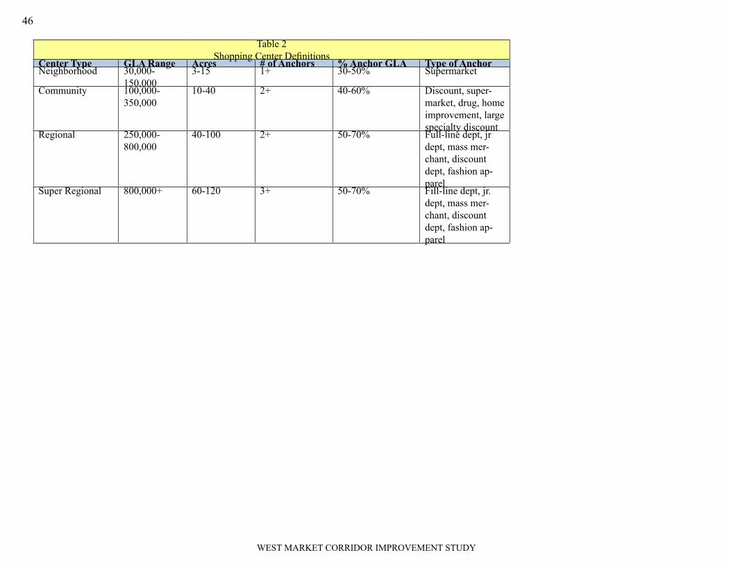
WEST MARKET CORRIDOR IMPROVEMENT STUDY
46
Table 2Shopping Center Definitions
Center Type GLA Range Acres # of Anchors % Anchor GLA Type of AnchorNeighborhood 30,000-
150,0003-15 1+ 30-50% Supermarket
Community 100,000-350,000
10-40 2+ 40-60% Discount, super-market, drug, home improvement, large specialty discount
Regional 250,000-800,000
40-100 2+ 50-70% Full-line dept, jr dept, mass mer-chant, discount dept, fashion ap-parel
Super Regional 800,000+ 60-120 3+ 50-70% Fill-line dept, jr. dept, mass mer-chant, discount dept, fashion ap-parel

W MARKET ST
CROP ST
W MAIN ST
ROWAN ST
W MUHAMMAD ALI BLVD
CEDAR ST
I264E
AS
T
PIRTLE ST
I264
WE
ST
GREEN ALY
HERMAN ST
LARKWOOD AVE
S38TH
ST
S32
ND
ST
S34
THS
T
S26TH
ST
S41
ST
ST
AM
YAV
E
S30
THS
T
S28
THS
T
S39
THS
T
CONGRESS ST
I264R
AM
P
W JEFFERSON ST
S25
THS
T
EDDY ST
TAIT
PL
CE
CIL
AVE
S40TH
ST
N24
THS
T
N25
THS
T
N26TH
ST
N36TH
ST N
28TH
ST
N29
THS
T
N30
THS
T
N35TH
ST
N34TH
ST
S27
THS
T
S24
THS
T
N37TH
ST
N32N
DS
T
S37TH
ST
S23
RD
ST
S33R
DS
T
S29
THS
T
S35TH
ST
N38TH
ST
S36TH
ST
BO
STO
NC
T
N39TH
ST
ACKERMAN CT
N40TH
ST
PIR
TLE
TER
N23
RD
STN
41ST
ST
LUE
THE
LC
T
N33R
DS
T
CR
OP
CT
CA
DB
UR
YC
T
S39TH
ST
ROWAN ST
W MAIN ST
S30
THS
T S28
THS
T
S24
THS
T
W JEFFERSON ST
W JEFFERSON ST
ROWAN ST
EDDY ST
S40
THS
T
S41S
TS
T
S23
RD
ST
LARKWOOD AVE
CONGRESS ST
EDDY ST
CONGRESS ST
I264
RA
MP
W MAIN ST
HERMAN ST
S24
THS
T
S29
THS
T
Copyright (c) 2007, LOUISVILLE AND JEFFERSONCOUNTY METROPOLITAN SEWER DISTRICT (MSD),
LOUISVILLE WATER COMPANY (LWC),LOUISVILLE METRO GOVERNMENT, and
JEFFERSON COUNTY PROPERTY VALUATIONADMINISTRATOR (PVA).
All Rights Reserved.
BPost, Econ Dev, 6-08
0 250 500 750 1,000Feet
± West Market Street Study AreaBike RoutesLegend
Bike Route

W MARKET ST
CROP ST
W MAIN ST
ROWAN ST
W MUHAMMAD ALI BLVD
CEDAR ST
I264E
AS
T
PIRTLE ST
I264
WE
ST
GREEN ALY
HERMAN ST
LARKWOOD AVE
S38TH
ST
S32
ND
ST
S34
THS
T
S26TH
ST
S41
STST
AM
YAV
E
S30
THS
T
S28
THS
T
S39
THS
T
CONGRESS ST
I264R
AM
P
W JEFFERSON ST
S25
THS
T
EDDY ST
TAIT
PL
CEC
ILAV
E
S40TH
ST
N24
THS
T
N25
THS
T
N26TH
ST
N36TH
ST N
28TH
ST
N29
THS
T
N30
THS
T
N35TH
ST
N34TH
ST
S27
THS
T
S24
THS
T
N37TH
ST
N32N
DS
T
S37TH
ST
S23
RD
ST
S33R
DS
T
S29
THS
T
S35TH
ST
N38TH
ST
S36TH
ST
BOST
ON
CT
N39TH
ST
ACKERMAN CT
N40TH
ST
PIR
TLE
TER
N23
RD
STN
41ST
ST
LUE
THE
LC
T
N33R
DS
T
CR
OP
CT
CA
DB
UR
YC
T
S39TH
ST
ROWAN ST
W MAIN ST
S30
THS
T S28
THS
T
S24
THS
T
W JEFFERSON ST
W JEFFERSON ST
ROWAN ST
EDDY ST
S40
THS
T
S41S
TS
T
S23
RD
ST
LARKWOOD AVE
CONGRESS ST
EDDY ST
CONGRESS ST
I264
RA
MP
W MAIN ST
HERMAN ST
S24
THS
T
S29
THS
T
Copyright (c) 2007, LOUISVILLE AND JEFFERSONCOUNTY METROPOLITAN SEWER DISTRICT (MSD),
LOUISVILLE WATER COMPANY (LWC),LOUISVILLE METRO GOVERNMENT, and
JEFFERSON COUNTY PROPERTY VALUATIONADMINISTRATOR (PVA).
All Rights Reserved.
BPost, Econ Dev, 6-08
0 250 500 750 1,000Feet
± West Market Street Study AreaTARC Routes and Stops
LegendRoute 12
Route15
Route 12 stops
Route 15 stops

W MARKET ST
CROP ST
W MUHAMMAD ALI BLVD
W MAIN ST
ROWAN ST
CEDAR ST
I264E
AS
T
I264
WE
ST
PIRTLE ST
LARKWOOD AVE
HERMAN ST
S38TH
ST
S32
ND
ST
GREEN ALY
S34
THS
T
S26TH
ST
S41
STST
AM
YAV
E
S30
THS
T
S28
THS
T
S39
THS
TCEC
ILAV
E
CONGRESS ST
I264R
AMP
W JEFFERSON ST
S25
THS
T
EDDY ST
TAIT
PL
S40TH
ST
N24
THS
T
N25
THS
T
S42
ND
ST
N26TH
ST
N36TH
ST N
28TH
ST
N29
THS
T
N30
THS
T
N35TH
ST
S27
THS
T
N34TH
ST
S24
THS
T
N37TH
ST
S37TH
ST
N32N
DS
T
S23
RD
ST
S33R
DS
T
S29
THS
TS
35THS
T
S36TH
ST
N38TH
ST
BOST
ON
CT
N39TH
ST
N40TH
ST
ACKERMAN CT
PIR
TLE
TER
LUE
THE
LC
T
N33R
DS
T
CR
OP
CT
CA
DB
UR
YC
T
S36
THS
T
S39TH
ST
ROWAN ST
W MAIN ST
S30
THS
T S28
THS
T
S24
THS
T
S35
THS
T
W JEFFERSON ST
W JEFFERSON ST
ROWAN ST
EDDY ST
S40
THS
T
S41S
TS
T
S24
THS
T
HERMAN ST
CONGRESS ST
EDDY ST
I264
RA
MP
W MAIN ST
LARKWOOD AVE
S29
THS
T
West Market Street Study Area
Land Use ChangesSINGLE-FAMILY RESIDENTIAL
MULTI-FAMILY RESIDENTIAL
PUBLIC and SEMI-PUBLIC
GENERAL COMM. AND OFFICE
0 250 500 750 1,000Feet
±Copyright (c) 2009, LOUISVILLE AND JEFFERSON
COUNTY METROPOLITIAN SEWER DISTRICT (MSD),LOUISVILLE WATER COMPANY (LWC),
LOUISVILLE METRO GOVERNMENT, andJEFFERSON COUNTY PROPERTY VALUATION
ADMINISTRATOR (PVA).All Right Reserved.
Existing Land UseCommercial
Industrial
Mulit-Family Res
Parks and Open Space
Public and Semi-public
Single Family Res
Vacant or Undeveloped
West Market Street Study Area2009 Land Use


11244
B-93-96
B-53-95
B-73-02B-72-02
B-135-06
B-243-01
B-180-93
B-127-92
B-157-91 B-242-89B-129-89
B-205-85B-174-85
09-059-04
09-004-95
09-048-91
09-060-79
09-043-80
09-033-97
09-050-77
09-012-79
09-047-90
W MARKET ST
CROP ST
W MAIN ST
ROWAN ST
DUNCAN ST
I264
EAST
I 264
WES
T
PIRTLE ST
LARKWOOD AVE
S41
STST
HERMAN ST
S38
THS
T
AMY
AVE
S34
THS
T
S32
ND
ST
S39
THS
TCOLUMBIA ST
N25
THST
CEC
ILAV
E
GREEN ALY
N26
THST
S26
THS
T
OWEN ST
W MUHAMMAD ALI BLVD
N24
THST
CONGRESS ST
S30
THS
T
I 264
RA
MP
N30
THST
W JEFFERSON ST
S28
THS
T
S25
THS
T
N28
THST
N29
THST
N32
ND
ST
N34
THST
CEDAR ST
N35
THST
TAIT
PL
S40
THS
T
N36
THST
S42
ND
ST
S24
THS
T
N37
THST
S37
THS
T
S23
RD
ST
S33
RD
ST
S29
THS
T
S35
THS
T
ST CECILIA ST
S36
THS
T
VERMONT AVE
N38
THST
S43
RD
ST
SLEVIN ST
BOST
ON
CT
N39
THST
PIR
TLE
TER
ACKERMAN CT
LUET
HEL
CT
N33
RD
ST
CR
OP
CT
W MAIN ST
CONGRESS ST
COLUMBIA ST
W MAIN ST
I264
RAM
P
S24
THS
T
ROWAN ST
W JEFFERSON ST
S28
THS
T
HERMAN ST
N29
THST
S24
THS
T
S39
THS
T
S41
STST
N28
THST
S30
THS
T
W JEFFERSON ST
S40
THS
T
LARKWOOD AVE
S42
ND
ST
West Market Street Study AreaPlan Certain and BOZA Cases Copyright (c) 2009, LOUISVILLE AND JEFFERSON
COUNTY METROPOLITAN SEWER DISTRICT (MSD),LOUISVILLE WATER COMPANY (LWC),
LOUISVILLE METRO GOVERNMENT, andJEFFERSON COUNTY PROPERTY VALUATION
ADMINISTRATOR (PVA).All Rights Reserved.
±
LegendBOZA Cases
APPEAL
CUP
VARIANCE
Plan Certain Cases
BOZA Cases
0 500 1,000250Feet
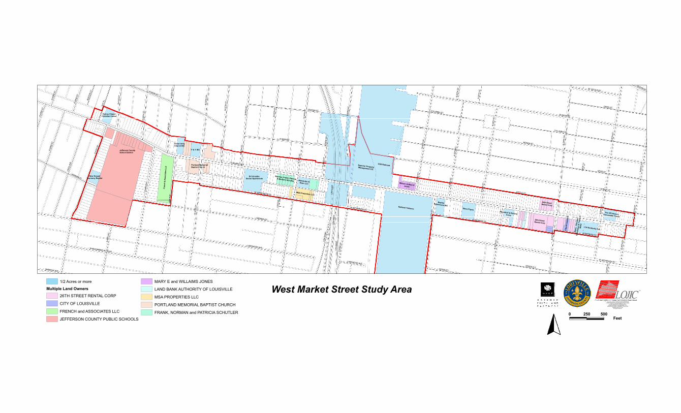
Jefferson CountySchool District
Fren
ch&
Ass
ocia
tes
LLC
Portland MemorialBaptist Church
Norman, Frank, Patricia& Barbara Schutler
MSA Properties LLC
William & Mary EJones
26th StreetRental Corp
City
ofLo
uisv
ille
Victroy ChapelChristian Center
New GospelHarmony Baptist
Christ UnityChurch INC
F & Y INC
St ColumbaSenior Apartments
Alexander &Dean LLC
Superior PropertyManagement CO.
CSX Railroad
National Tobacco
BaptistTabernacle INCSteve Payne
Rhonda E & RolandCurry
Gle
nn,
Vane
ssa,
Otis
Rob
ert &
Tony
aD
Mill
er
26th StreetRental Corp
Chi Kentucky Inc
The CR HeavrinIrrevocable Treust
W MARKET ST
CROP ST
W MAIN ST
ROWAN ST
DUNCAN ST
I264
EAST
LARKWOOD AVE
I264
WES
T
PIRTLE ST
HERMAN ST
S41
STST
S38
THS
T
AMY
AVE
S34
THS
T
S32
ND
ST
S39
THS
T
N25
THST
COLUMBIA ST
CEC
ILAV
E
N26
THST
S26
THS
T
W MUHAMMAD ALI BLVD
OWEN ST
CONGRESS ST
S42
ND
ST
GREEN ALY
I264
RA
MP
S30
THS
T
N30
THST
W JEFFERSON ST
S25
THS
T
S28
THS
T
N28
THST
N29
THST
N24
THST
N32
ND
ST
N34
THST
N35
THST
TAIT
PL
N36
THST
S40
THS
T
N37
THST
S24
THS
T
S37
THS
T
ST CECILIA ST
CEDAR ST
S33
RD
ST
S29
THS
T
S35
THS
T
N38
THST
S36
THS
T
S43
RD
ST
VERMONT AVE
BOST
ON
CT
N39
THST
SLEVIN ST
PIR
TLE
TER
LUET
HEL
CT
N33
RD
ST
CR
OP
CT
W MAIN ST
CONGRESS ST
COLUMBIA ST
W MAIN ST
S30
THS
T
S42
ND
ST
S24
THS
T
S43
RD
ST
ROWAN ST
W JEFFERSON ST
S28
THS
T
S41
STST N
29TH
ST
S39
THS
T
HERMAN ST
N28
THST
I 264
RAM
P
W JEFFERSON ST
S40
THS
T
LARKWOOD AVE
S24
THS
T
1/2 Acres or more
Multiple Land Owners
26TH STREET RENTAL CORP
CITY OF LOUISVILLE
FRENCH and ASSOCIATES LLC
JEFFERSON COUNTY PUBLIC SCHOOLS
MARY E and WILLAIMS JONES
LAND BANK AUTHORITY OF LOUISVILLE
MSA PROPERTIES LLC
PORTLAND MEMORIAL BAPTIST CHURCH
FRANK, NORMAN and PATRICIA SCHUTLER
West Market Street Study AreaCopyright (c) 2009, LOUISVILLE AND JEFFERSON
COUNTY METROPOLITAN SEWER DISTRICT (MSD),LOUISVILLE WATER COMPANY (LWC),
LOUISVILLE METRO GOVERNMENT, andJEFFERSON COUNTY PROPERTY VALUATION
ADMINISTRATOR (PVA).All Rights Reserved.
0 250 500Feet±
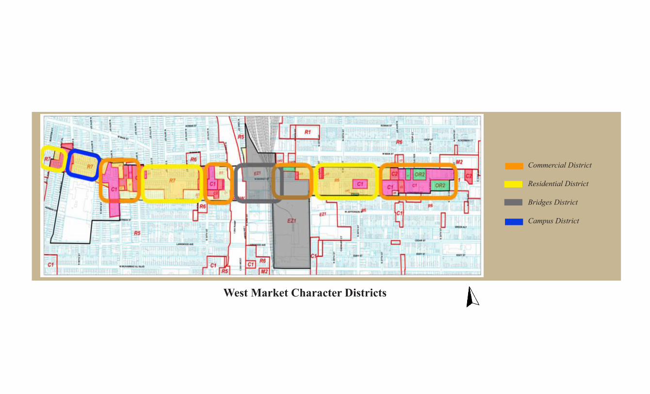
Commercial District
Residential District
Bridges District
Campus District
West Market Character Districts

W MARKET ST
CROP ST
W MUHAMMAD ALI BLVD
W MAIN ST
ROWAN ST
CEDAR ST
I264E
AS
T
I264
WE
ST
PIRTLE ST
LARKWOOD AVE
HERMAN ST
S38TH
ST
S32
ND
ST
GREEN ALY
S34
THS
T
S26TH
ST
S41
STST
AM
YAV
E
S30
THS
T
S28
THS
T
S39
THS
TCEC
ILAV
E
CONGRESS ST
I264R
AMP
W JEFFERSON ST
S25
THS
T
EDDY ST
TAIT
PL
S40TH
ST
N24
THS
T
N25
THS
T
S42
ND
ST
N26TH
ST
N36TH
ST N
28TH
ST
N29
THS
T
N30
THS
T
N35TH
ST
S27
THS
T
N34TH
ST
S24
THS
T
N37TH
ST
S37TH
ST
N32N
DS
T
S23
RD
ST
S33R
DS
T
S29
THS
T
S35TH
ST
S36TH
ST
N38TH
ST
BOST
ON
CT
N39TH
ST
N40TH
ST
ACKERMAN CT
PIR
TLE
TER
LUE
THE
LC
T
N33R
DS
T
CR
OP
CT
CA
DB
UR
YC
T
S36
THS
T
S39TH
ST
ROWAN ST
W MAIN ST
S30
THS
T S28
THS
T
S24
THS
T
S35
THS
T
W JEFFERSON ST
W JEFFERSON ST
ROWAN ST
EDDY ST
S40
THS
T
S41S
TS
T
S24
THS
T
HERMAN ST
CONGRESS ST
EDDY ST
I264
RA
MP
W MAIN ST
LARKWOOD AVE
S29
THS
T
West Market Street Study Area2009 Vacant Buildings and Lots
West Market Street Study Area
Vacant Property
VACANT BUILDING
VACANT LOT
Commercial Node0 250 500 750 1,000Feet±
Copyright (c) 2009, LOUISVILLE AND JEFFERSONCOUNTY METROPOLITIAN SEWER DISTRICT (MSD),
LOUISVILLE WATER COMPANY (LWC),LOUISVILLE METRO GOVERNMENT, and
JEFFERSON COUNTY PROPERTY VALUATIONADMINISTRATOR (PVA).
All Right Reserved.

W MARKET ST
CROP ST
W MUHAMMAD ALI BLVD
W MAIN ST
ROWAN ST
CEDAR ST
I264E
AS
T
I264
WE
ST
PIRTLE ST
LARKWOOD AVE
HERMAN ST
S38TH
ST
S32
ND
ST
GREEN ALY
S34
THS
T
S26TH
ST
S41
STST
AM
YAV
E
S30
THS
T
S28
THS
T
S39
THS
TCEC
ILAV
E
CONGRESS ST
I264R
AMP
W JEFFERSON ST
S25
THS
T
EDDY ST
TAIT
PL
S40TH
ST
N24
THS
T
N25
THS
T
S42
ND
ST
N26TH
ST
N36TH
ST N
28TH
ST
N29
THS
T
N30
THS
T
N35TH
ST
S27
THS
T
N34TH
ST
S24
THS
T
N37TH
ST
S37TH
ST
N32N
DS
T
S23
RD
ST
S33R
DS
T
S29
THS
T
S35TH
ST
S36TH
ST
N38TH
ST
BOST
ON
CT
N39TH
ST
N40TH
ST
ACKERMAN CT
PIR
TLE
TER
LUE
THE
LC
T
N33R
DS
T
CR
OP
CT
CA
DB
UR
YC
T
S36
THS
T
S39TH
ST
ROWAN ST
W MAIN ST
S30
THS
T S28
THS
T
S24
THS
T
S35
THS
T
W JEFFERSON ST
W JEFFERSON ST
ROWAN ST
EDDY ST
S40
THS
T
S41S
TS
T
S24
THS
T
HERMAN ST
CONGRESS ST
EDDY ST
I264
RA
MP
W MAIN ST
LARKWOOD AVE
S29
THS
T
West Market Street Study AreaPotential for Redevelopment
West Market Street Study Area
Potential for Redevelopment
1ST PRIORITY
2ND PRIORITY
3RD PRIORITY0 250 500 750 1,000Feet±
Copyright (c) 2009, LOUISVILLE AND JEFFERSONCOUNTY METROPOLITIAN SEWER DISTRICT (MSD),
LOUISVILLE WATER COMPANY (LWC),LOUISVILLE METRO GOVERNMENT, and
JEFFERSON COUNTY PROPERTY VALUATIONADMINISTRATOR (PVA).
All Right Reserved.
Top Related