


Languages
Pages
Legal

2015/2016 Land Between
The Lakes NRA Hunt AreaMap Book
*The legal status of LBL Roads is subject to change.Please refer to the current LBL MVUM map for legalroad status.

2013/2014 Land Between The Lakes NRA Hunt Map Book
Please see legend page of Land Between The Lakes' Hunt Map Grid Booklet for important information and map symbol descriptions.
Map published August 2015.This map is intended as a recreation aid only.
Table of ContentsMap GridLegendHunt Area 1Hunt Area 2Hunt Area 3Hunt Area 4Hunt Area 5Hunt Area 6Hunt Area 7Hunt Area 8Hunt Area 9Hunt Area 10Hunt Area 11Hunt Area 12Hunt Area 13Hunt Area 14Hunt Area 15Hunt Area 16
Page 3Page 4Page 5Page 6Page 7Page 8Page 9
Page 10Page 11Page 12Page 13Page 14Page 15Page 16Page 17Page 18Page 19Page 20
-------------------------------------------------- -------------------- -------------------- -------------------- -------------------- -------------------- -------------------- -------------------- -------------------- -------------------- ------------------- ------------------- ------------------- ------------------- ------------------- ------------------- ------------------
2

HUNTAREA10HUNTAREA11 HUNTAREA12HUNTAREA13
HUNTAREA14
HUNTAREA15HUNTAREA16
HUNTAREA4HUNTAREA3
HUNTAREA6HUNTAREA7
HUNTAREA5
HUNTAREA8
HUNTAREA9
HUNTAREA1 HUNTAREA2
87°55'0"W
87°55'0"W
88°0'0"W
88°0'0"W
88°5'0"W
88°5'0"W
88°10'0"W
88°10'0"W88°15'0"W88°20'0"W88°25'0"W88°30'0"W
87°50'0"W 87°45'0"W 87°40'0"W
37°5
'0"N
37°0
'0"N
36°5
5'0"N
36°5
5'0"N
36°5
0'0"N
36°5
0'0"N
36°4
5'0"N
36°4
5'0"N
36°4
0'0"N
36°4
0'0"N
36°3
5'0"N
36°3
5'0"N
36°3
0'0"N
36°2
5'0"N
37°5'0"N
µ2015/2016 Land Between The Lakes NRA Hunt Area Grid Index
Please see legend page of Land Between The Lakes' Hunt Map Grid Booklet for important information and map symbol descriptions.
0 2 4 6 8 10Miles
Map published August 2015.This map is intended as a recreation aid only.
1:300,000
3

NATURE WATCH AREAS AND DEVELOPED RECREATION SITES (INCLUDING CAMP- GROUNDS, PICNIC AREAS, AND LAKE ACCESS AREAS) ARE CLOSED TO HUNTING UNLESS SPECIFICALLY AUTHORIZED.NO HUMAN ENTRY INTO WILDLIFEREFUGES DURING CLOSED DATES.NO HUNTING IN WILDLIFE REFUGESAT ANY TIME.NO DISCHARGE OF A FIREARM OROTHER IMPLEMENT CAPABLE OFTAKING ANIMAL LIFE WITHIN 150YARDS OF ANY DEVELOPED AREA.PAINT, TAPE, FLAGGING OR OTHERARTIFICIAL MATERIALS SHALL NOT BEUSED TO MARK TREES, TRAILS, ORROUTESPARKING IS PERMITTED WITHIN ONEVEHICLE LENGTH OF A LEGAL ROAD.BLOCKING ACCESS TO ANY ROAD ORTRAIL IS PROHIBITED. RUTTING OFFIELDS IS PROHIBITED. DO NOTLEAVE CAMPFIRE RINGS (ROCKS) INFIELDS.VEHICLES PERMITTED ONNUMBERED ROADS ONLY. SEEMOTORIZED VEHICLE MAP (MVUM)FOR OFFICIAL DRIVABLE ROADS:http://www.landbetweenthelakes.us/visit/maps/VIOLATORS SHALL BE PUNISHED BY AFINE OF NOT MORE THAN $5,000 OR IMPRISONMENT FOR NOT MORE THAN SIX MONTHS OR BOTH PURSANT TO TITLE 16 U.S.C., SECTION 551.
FOR MORE INFORMATION ON REGULATIONS, SEEhttp://www.landbetweenthelakes.us/seendo/outdoor-rec/hunting/
2015/2016 Land Between The Lakes NRA - Hunt Map
Map published August 2015.This map is intended as a recreation aid only.
LegendScenic Byway, Open to Highway Legal VehiclesOnly, Yearlong
State or US HighwayOther Public RoadTrailIntermittent StreamPerennial StreamContours (40 foot)Hunt Area Boundary
R R RR R RR R R Forest Service Refuge
Closed Nov 1 - Mar 15
KY Fish & Wildlife RefugeClosed Nov 1 - Feb 15R R R
R R R
Oak Grassland Demonstraition Area
Nature Watch AreaArchery Only Deer Hunting
Turkey Bay OHV Area (Archery Only Deer Hunting)
Developed Recreation Area (No Hunting)
Non-Forested AreaForested AreaUSFS Boundary
Road Open to Highway Legal Vehicles Only,Yearlong
Interstate
Road Open to Highway Legal Vehicles Only,SeasonalSpecial VehicleDesignation, Yearlong
State Natural Area
sInterpretive Auto Route
!8 Backcountry Camp
!Õ Boat Ramp
!Z Cultural Interest
Developed Campground!9
!» Dump Station
"@ Forest Admin
!: Group Camp
!È Horseback Riding
"7 Hunter Check Station!N OHV Area
"5 Picnic Area
!O Shooting, Archery Range
!CTrailhead
!]Visitor Center or Welcome Station

400
400
400
400
400
400
400
400
400
400
400
400
400
400
400
400
400
400
400
400
400
400
400
400
400
400
400
400
400
400
400
400
400
400
400
400
400
400
400
400
400
400
400
400
400400
400
400
400
400
400
400
400
400
400
400
400
400
400
400
400
400
400
400
400
400
400
400
400
400
400
400
400
400
400
400
400
400
400
400
400
400
400
400
400
400
400
400
400
400
400
600
400
400
400
400
400
400
400
400
400
400
400
400
400
400
400
400
400
400
400
400
400
400
400
400
400
400
400
400
400
400
!Õ
!Õ
!Õ
!Õ
!Õ
!Õ!Õ
!Õ
!Õ
!Õ
h
h
h
h
h
h
h
h
h
h
h
h
h
h
h
h
h
h
h
h
h
h
hh
h
h
h
h
hhh
E
E
E
E
E
E
E
E
E
E
E
E
E
E
E
E
E
E
E
E
E
E
E
E
E
E
E
E
E
E
E
E
E
E
E
E
E
E
E
E
E
E
EE
E
E
E
E
E
E
E
E
E
!8
!8
!]
!9
!8
!9
"5
"5
!8
!8
!8

400
400
400
400
400
400
400
400
400
400
400
400
400
400
400
400
400
400
400
400
400
400
400
400
400
400
400
400
400
400
400
400
400
400
400
400
400
400
400
400
400
400
400
400
400
400
400
400
400
400
400
400
400
400
400
400
400
400
400
400
400
600
400
400
400
400
400
400
400
400
400
400
400
400
400
400
400
400
400
400
400
400
400
!Õ
!Õ
h
h
h
h
h
h
h
h
h
h
hh
h
h
h
hh
E
E
E
E
E
E
E
E
E
E
E
E
E
E
E
E
E
E
E
E
E
E
E
E
EE
E
E
E
E
E
E
!8
!9
"5
!8

400
400
400
400
400
400
400
400
400
400
400
400
400
400
400
400
400
400
400
400
400
400 400
400
400
400
400
400
400
400
400400
400
400
400
400
400
400
400
400
h
h
h
h
h
h
h
E
E
E
E
E
E
E
E
E
E
E
E
E
E
E
E
E
E
!9"5
!8
!8
!8
!8
!Õ
!Õ
!Õ
!ÕMcWaters
Cem
Ingram Cem
Pinnegar Cem
Lofton Cem
Stone 1 Cem
Fulks Cem
Mitchusson Cem
Newby Cem
Duncan Cem
Higgins 4 Cem
Isaac Gray Cem
Ruben Collie Cem
Barnett Cem
Watkins InfantCem
BohanonCem
WashburnCem
GarrettGrayCem3
HUNTAREA
LYON COUNTYTRIGG COUNTY
MARSHALL COUNTY
2HUNTAREA
LeeDoddCem
R
SUGAR BAY
BIRMINGHAMFERRY
SMITH BAY
STARCAMP
PISGAHPOINT
HILLMANFERRY
WOODLANDSNATUREWATCHAREA
Barnes Hollow
Racetrack Hollow
Curry Hollow
305
306
307
308
139
318
ËÉ114
ËÉ111-A
ËÉ116
ËÉ130
ËÉ130
ËÉ129
ËÉ310
ËÉ311ËÉ313
ËÉ131
ËÉ312
ËÉ133ËÉ132
WOODSON CHAPEL ROAD
NORTH-SOUTH TRAIL
ËÉ316
ËÉ139
ËÉ135
ËÉ320
ËÉ139
ËÉ100
ËÉ100
M U L BERRY FLATRO
AD
SILVER TRAIL ROAD
KENTUCKYLAKESugar Bay
Duncan BayDuncanLake
Smith Bay
Pisgah Bay
South Fork Sugar Creek
North Fork Sugar Crk
Smith Creek
Pisgah Creek
Dodds Creek
Cravens Creek
Duncan Creek
Fulton Creek
TRACE
NATIONAL
88°7'30"W
88°7'30"W88°9'0"W88°10'30"W
88°6'0"W 88°4'30"W
36°5
5'30"N
36°5
5'30"N
36°5
4'0"N
36°5
4'0"N
36°5
2'30"N
88°9
'0"W
88°1
0'30"W 88°6
'0"W
88°4
'30"W
R
RR
R
4 0 0.5 1Miles
2015/2016 Land Between The Lakes NRAHunt Area 3 Map
Map published August 2015.This map is intended as a recreation aid only.
Please see legend page of Land Between The Lakes Hunt MapBooklet for important information and map symbol descriptions.
1:40,000
7

400
400
400
400
400
400
400
400
400
400
400
400
400
400400
400
400
400
400
400
400
400
400
400
400
400400
400
400
400
400
400
400
400
400
400
400
400
400
400
400
400
400 400
400
400
400
400
400400
400
400
400
400
400
400
400
400
600
400
400
400
400
400
400
400
400
400
400
400
400
400
400
400
400
!Õ
h
h
h
h
h
E
E
E
E
E
E
E
E
E
E
E
E
E
E
E
E
E
E
E
E
!9

400
400
400
400
400
400
400
400
400
600
600
400
600
400
400
400
400
400
400
400
400
400
400
400
400
400
400
400
400
400
600
600
600
600
600
400
400
400
400
400
400
400
400
400
400
600
400
600
600
400
400
400
400
400
400
400 400
400
400
400
400
400
600
600
400
600
600
400
400
400
400
400
400
400
400
400
400
400
400
400
400
400
400
600
600
600
400
600
400
400
400
400
400
400
400
400
400
400
400
600
600
600
400
400
400
400
400
400
400
400
400
400
400
400
400
400
400
400
400
600
600
400
400
400
400
400
400
400
400
400
400
400
400
400
600
600
600
400
h
h
h
h
h
h
h
h
h
h
h
E
E
E E
E
E
E
E
E
E
E
E
E
E
E
E
E
E
E
E
E
E
E
EE
E
E
E
E
E
E
E
E
E
E
E
E
E
E
E
E
E
"5
!8
!9
!8
![
"5
!]
!9
"7
!C
!O!C
!C
"@
!»
s
!Õ
!Õ
!Õ
!Õ
!Õ
!C
!C
!C
Travis Cem
No Name 2 Cem
Roach 2 Cem Ross 1
Cem
Meredith Cem
Turner Cem
Smith Cem
Vickers Cem
Chambers Cem
Savells Cem
Cassity Cem Higgins 1
Cem
Pleasant Valley Cem
Litchfield Cem
Reynolds Cem George Higgins
Cem
Mitchell Cem
Rhoades Cem
Higgins 3 Cem
Cumberland - Matheny,Ferguson Springs, &
Matheny Cems.
Brown Cem
McWaters Cem
Ingram Cem
Pinnegar Cem
Lofton Cem
Stone 1 Cem
Mitchusson Cem
Newby Cem
Duncan Cem
Taylor 1 Cem
Salem Cem
Franklin Cem
Ferguson Spring Cem
Oakley Cem
Luton Cem
Jenny Ridge Cem
Bogard Cem
Lowery Cem
Atwood Cem
Newton Cem
6HUNTAREA
7HUNTAREA
5HUNTAREA
Aurora
LYON COUNTYTRIGG COUNTY
MARSHALL COUNTY
MARSHALL COUNTY
Griffin Cem
LoneGrave 3
Cem
Eggner FerryBridgeTo Murray
Fire Tower
R
GOLDEN PONDTARGET RANGE
JENNYRIDGE
TURKEY BAYOHV AREA
ELK & BISONPRAIRIE
SUGAR BAY
ENERGY LAKE
ENERGY DAM
TAYLOR BAY
Turner Hollow
Gordo
n Hollow
WOODLANDS NATURE WATCH AREA
Boardinghouse Hollow
Barnes Hollow
KENLAKE STATE RESORT PARK FENTON
OAK GRASSLANDDEMONSTRATION AREA
GOLDEN PONDVISITOR CENTER & PLANETARIUM
139
318412
319
141
335
141
338
337
143
322
324
323
326
ËÉ134
¬«402
ËÉ316
ËÉ139
ËÉ140
ËÉ135ËÉ135
ËÉ135
ËÉ136
ËÉ134ËÉ320
ËÉ144 ËÉ321
ËÉ139
ËÉ142
ËÉ144
ËÉ153
ËÉ152
ËÉ146
ËÉ153
ËÉ153
ËÉ149
145
147
ËÉ336
ËÉ141
ËÉ165 ËÉ160
ËÉ165
ËÉ100
ËÉ100
ËÉ100
ËÉ100
M U L BER RY FLATRO
AD
JENNY
RIDGE ROAD
£¤68
£¤68 ¬«80
£¤68
CENTRALHARDWOODS
SCENICTRAIL
CENTRALHARDWOODSSCENICTRAIL
EnergyLake
GoldenPond
Barnett Bay
Vickers Bay
Higgins Bay
Sugar Bay
Duncan Bay
Jonathan Creek
Elbow Creek
Barnett Creek
Vickers Creek
Crooked Creek
Savells Branch
Rhodes Creek
Higgins Branch
South Fork Sugar Creek
Crooked Creek
Franklin Creek
Little Creek
Jake Fork
Long Creek
North Fork Sugar Crk
Taylor Creek
Shaw Branch
Pond Creek
Rhodes Bay
Duncan Creek
Gilbert Creek
Grace C
reek
SCENICBYWAY
NORTH / SOUTH TRAIL
¬«80
88°4'30"W
88°4'30"W
88°6'0"W
88°6'0"W88°7'30"W88°9'0"W
88°3'0"W 88°1'30"W
36°5
2'30"N
36°5
1'0"N
36°5
1'0"N
36°4
9'30"N
36°4
9'30"N
36°4
8'0"N
36°4
8'0"N
36°4
6'30"N
88°7
'30"W
88°9
'0"W
88°3
'0"W
R
RR
R
4 0 0.5 1Miles
2015/2016 Land Between The Lakes NRAHunt Area 5 Map
Map published August 2015.This map is intended as a recreation aid only.
Please see legend page of Land Between The Lakes Hunt MapBooklet for important information and map symbol descriptions.
1:55,000
9

400
400
400
400
400
400
400
400
400
400
400
400
400400
400
400
400
400
400
400
400
400
400
400400 400
400
400
400
400
400
400
400
400
400
400
400
400
400
400
400
400
400
400
400
400
400
400
400
400
400
400
400
400
400
400
400
400
400
400
400
400
400
400
400
400
400
400
400
400
400
400
400
400
400
400
400
400
400
400
400
400
400
400
400
400
400
400
400
400
400
!Õ
h
h
E
E
E
E
E
E
E
E
E
E
E
E
E
E
E
E E
E
E
E
"5
"5
!8
!9

400
600
600
400
600
400
400
400
400
400
400
400
400
400
400
400
400
400
400
400
400
400
400
600
600
600
600
600
400
400
400
400
400
400
400
400
600
600
600
600
600
600
400
400
400
400
400
400
400
400
400
400
400
400
400
400
400
600
600
600
600
600
400
400
400
400
400
400
400
400
400
400
400
400
400
400
400
600
600
600
400
600
600
400
400
400
400
400
400
400
400
400
400
400
600
600
600
600
400
400400
400
400
400
400
400
400
400
400
400
400
600
600
400
400
600
400
400
400
400
400
400
400
600
600
600
400
400
400
400
400
400
400
400
400
400
400
400
400
400
!Õ
!Õ
!Õ
h
h
h
h
h
h
h
h
h
h
h
E E
EE
E
E
E
E
E
E
E
E
E
E
E
E
E
E
E
E
E
E
E
E
E
E
E
E
E
E
E
E
E
E
E
E
E
E
E
E
E
E
!8
!9
![
"5
!]
!9
!N
"7
!C
!O!C
"@
!»
s
!Õ
!Õ
!Õ
!Õ
!Õ
"5
!C!C
!C
!C
!C
TravisCem
No Name 2Cem
Hendon 2Cem
Roach 2Cem
Catholic 1Cem
Futrell 4Cem
Long Creek Cem
Harper Cem
Johnstone Cem
DixonCem
Compton 1 Cem
Ross 1 Cem
Meredith Cem
TurnerCem
VickersCem
Higgins 1Cem
Pleasant Valley Cem
Litchfield Cem
MitchellCem
RhoadesCem
Cumberland - Matheny,Ferguson Springs, &
Matheny Cems.
McWatersCem Hematite
Cem
Taylor 1 Cem
Salem Cem
Franklin Cem
Ferguson Spring Cem
Oakley Cem
Cumberland Cem
Wallace CemGrace
Cem
Luton Cem
Jenny Ridge Cem
Bogard Cem
Lowery Cem
Indian Springs Cem Malone
Cem
Atwood Cem
Newton Cem
6HUNTAREA
7HUNTAREA
5HUNTAREA
8HUNTAREA
Canton
GriffinCem
LoneGrave 3
Cem
Henry R.LawerenceBridge
Fire Tower
GOLDEN PONDTARGET RANGE
JENNYRIDGE
DEVILSELBOW
TURKEYBAYOHV AREA
ELK & BISONPRAIRIE
RIVERS ENDLAUNCHING AREA
ENERGY LAKE
ENERGY DAM
TAYLORBAY
Turner Hollow
Pryor HollowGordo
n Hollow
Oakley H oll ow
WOODLANDSNATUREWATCHAREA
Boardinghouse Holl ow
Barnes Hollow
DEVIL'S ELBOWLAUNCHING AREA
FENTON
OAK GRASSLANDDEMONSTRATION AREA
GOLDEN PONDVISITOR CENTER & PLANETARIUM
TO LAKE BARKLEY
STATE RESORT PARK
318
335
141
143
342
159-S
158
157
156
333 155
322
324
323
326
327
329
330
331
328-A
328-B
ËÉ316
ËÉ139ËÉ135
ËÉ135
ËÉ134ËÉ320
ËÉ144 ËÉ321
ËÉ142
ËÉ144 ËÉ134
ËÉ134
ËÉ134
ËÉ153ËÉ153
ËÉ152
ËÉ146
ËÉ153
ËÉ153
ËÉ149
145
147
ËÉ336
ËÉ141
ËÉ165 ËÉ160
ËÉ151
ËÉ165
ËÉ344
ËÉ100
ËÉ100
ËÉ100M U L BERRY FLAT
ROAD
JENNY
RIDGE ROAD
£¤68£¤68
¬«80
¬«80
WRANGLERS TRAIL SYSTEM
WRAN
GLERS TRAIL SYSTEM
CENTRALHARDWOODS
SCENICTRAIL
CENTRALHARDWOODS
SCENICTRAIL
CENTRALHARDWOODSSCENICTRAIL
Taylor Bay
Jake Fork Bay
Crooked Creek Bay
EnergyLake
Elbow Bay
Cum berlandRiver
GoldenPond
Little River
Hopson Creek
Lick Creek
Bacon Creek
Elbow Creek
Barnett Creek
Vickers Creek
Crooked Creek
Rhodes Creek
Higgins Branch
Crooked Creek
Franklin Creek
Little Creek
Jake Fork
Long Creek
North Fork Sugar Crk
Taylor Creek
Shaw Branch
Pond Creek
Shanklin Creek
Long Creek
Goose Cree
k
Gilbert Creek
Grace C
reek
CumberlandRiver
WOODLANDS
SCENICBYWAY
NORTH / SOUTH TRAIL
¬«80
88°1'30"W
88°1'30"W
88°3'0"W
88°3'0"W88°4'30"W88°6'0"W
88°0'0"W 87°58'30"W
36°5
2'30"N
36°5
1'0"N
36°5
1'0"N
36°4
9'30"N
36°4
9'30"N
36°4
8'0"N
36°4
8'0"N
36°4
6'30"N
88°4
'30"W
88°6
'0"W
88°0
'0"W
36°52'30"N
R
RR
R
4 0 0.5 1Miles
2015/2016 Land Between The Lakes NRAHunt Area 7 Map
Map published August 2015.This map is intended as a recreation aid only.
Please see legend page of Land Between The Lakes Hunt MapBooklet for important information and map symbol descriptions.
1:55,000
11
600
400
600
400
600
600
600
600
600
600
600
400
400
400
400
400 400
400
400
400
400
400
400
400
600
600
600
600
600
600
600
400
400
400600
600
400
400
600
600
600
400
600
600
600
600
600
600
400
400
400
400
400
400
400
400
400
400
600
400
400
400
600
600
600
600
600
600
600
400
400
400
400
400
400
400
400 400
400
600
600
600
400
600
600
600
600
600
400
400
400
400
400
400
400
400
400
400
600
600
400
600
400
600
600
600
600
400
400
400
400
400
400
400400
400
400
600
600
600600
600
600
600
400
400
400
400
600
600
400
600
600
400
400
400
400
400
400
400
400
400
400
400
400
!Õ
!Õ
!Õ
h
h
h
h
h
h
h
h
h
h
h
h
h
h
h
E E
E
E
E
E
E
E
E
E
E
E
E
E
E
E
E
E
E
E
E
E
E
E
E
E
E
E
E
E
E
E
E
E
E
E
E
E
E
E
E
E
E
E
E
E
E
E
E
E
E
E
![
"5
!]
!N
"7
!9
"5!:
!8
!O!C
"@
!»
s
!È
!Õ
!Õ
!Õ
"5
!C!C
!C
!C
!C
Lane Infant Cem
Roach 2 Cem
Davis Cem
Mays Cem
Schneider Cem
Turkey Creek Cem
Remenschneider Cem
Neeble Cem
Wenger Cem
Catholic 1 Cem
Catholic 2 Cem
Futrell 4Cem
Downs 1 Cem
Vinson 1 Cem Fords
Cem
Hicks 1 Cem
ComptonFamily Cem
Futrell 2 CemBlossey
Cem
Bullock Cem
Carr FarmCem
HawkinsCem
Bethlehem 2 Cem
Hanes Cem
Henson Cem
Long Creek Cem
Harper Cem
Johnstone Cem
Dixon Cem
Pleasant Hill Cem
Futrell 3 Cem
Futrell Little Drummer Boy
Cem
Futrell 1 Cem
Colson Negro Cem
Compton 1 Cem
Ross 1 Cem
Meredith Cem
Turner Cem
Pleasant Valley Cem
Litchfield Cem
Cumberland - Matheny,Ferguson Springs, &
Matheny Cems.
Grace Cem
Luton Cem
Jenny Ridge Cem
Bogard Cem
Lowery Cem
Indian Springs Cem Malone
Cem
Atwood Cem
Newton Cem
10HUNTAREA
7HUNTAREA
8HUNTAREA
9HUNTAREA
Canton
Griffin Cem
LoneGrave 3
Cem
Kopperud Cem
Henry R.LawerenceBridge
Fire Tower
GOLDEN PONDTARGET RANGE
JENNYRIDGE
DEVILSELBOW
TURKEY BAYOHV AREA
COLSON HOLLOWGROUP CAMP COLSON OVERLOOK
WRANGLERS
ELK & BISONPRAIRIE
REDD HOLLOW
Turner Hollow
Pryor Hollow
Mays Hol low
Gordo
n Hollow
Wienger Hollow
Redd Hollow
Oakley Ho ll ow
DONALDSON CREEKLAUNCHING AREA
CALHOUN HILLLAUNCHING AREA
DEVIL'S ELBOWLAUNCHING AREA
WATERFOWL
REFUGEKDF W
R
GOLDEN PONDVISITOR CENTER & PLANETARIUM
TO LAKE BARKLEY
STATE RESORT
PARK
141
143
350
358
353
355
354352
352
347
348
406
346
345
342
159-S
158
157
356
NORTH-SOUTH TRAIL
ËÉ134
ËÉ153ËÉ153
ËÉ153
ËÉ153
ËÉ149
ËÉ336
ËÉ141
ËÉ165 ËÉ160
ËÉ151
ËÉ165
ËÉ413
ËÉ167
ËÉ168
ËÉ169
ËÉ170 ËÉ166
ËÉ344
ËÉ165
ËÉ165
ËÉ349ËÉ171
ËÉ174
ËÉ165
ËÉ100
ËÉ100
ËÉ100 JENNYRIDGE ROAD
F ORDS
ROAD
BAY
£¤68£¤68
¬«80
¬«80
TRACE
343
£¤68
¬«80
¬«164
WRANGLERS TRAIL SYSTEM
WRAN
GLERS TRAIL SYSTEM
CENTRALHARDWOODS
SCENICTRAIL
CENTRALHARDWOODSSCENICTRAIL
Elbow Bay
GoldenPond
Turkey Bay
Hopson Creek
Lick Creek
Donaldson Creek
Fords BayBlockhouse Creek
West Fork Laura Furnace Creek
Turkey Creek
Lick Creek
Bacon Creek
Elbow Creek
Barnett Creek
Vickers Creek
Crooked Creek
Pond Creek
Shanklin Creek
Parsons Creek
Terrapin Creek
Downs Branch
Long Creek
LAUR
A FURN
ACE CREEK
Gilbert Creek
Grace Creek
Cumberland River
WOODLANDS
NATIONAL
SCENIC
BYWAY
SOUTH TRAIL
88°0'0"W
88°0'0"W
88°1'30"W
88°1'30"W88°3'0"W88°4'30"W
87°58'30"W 87°57'0"W
36°4
8'0"N
36°4
6'30"N
36°4
6'30"N
36°4
5'0"N
36°4
5'0"N
36°4
3'30"N
36°4
3'30"N
36°4
2'0"N
88°4
'30"W
36°48'0"N
R
RR
R
4 0 0.5 1Miles
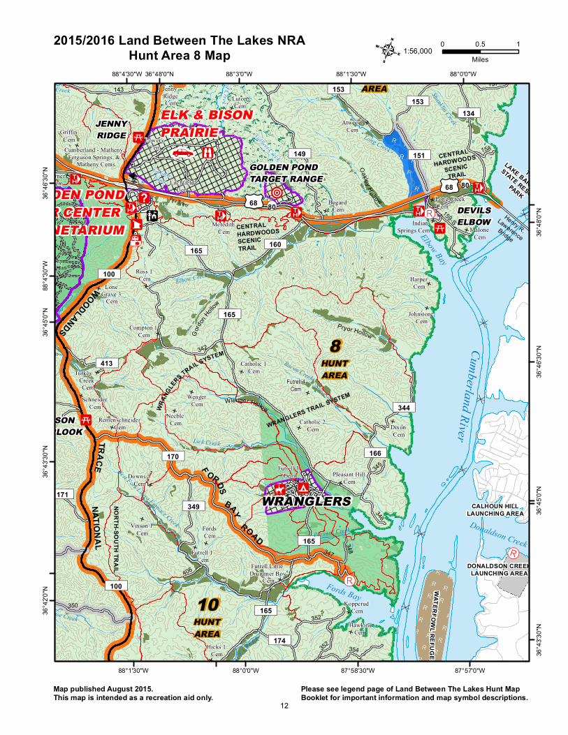
2015/2016 Land Between The Lakes NRAHunt Area 8 Map
Map published August 2015.This map is intended as a recreation aid only.
Please see legend page of Land Between The Lakes Hunt MapBooklet for important information and map symbol descriptions.
1:56,000
12

400
600
400
600
400
600
600
400
600
600
600
600
600
400
400
400
400 400
400
400
400
400
400
400
400
400
400
400
400
400
400
600
600
600
600
600
400
600
600
400
400
400
400
400
600
600
400
400
400
600
400
400
600
600
400
600
600
600600
600
600
400
400
400
400
400
400
400
400
400
400 400
400
400
400
400
600
400
400
400
600
600
600
600
600
600
400
400
600
400
400
400
400
400
400
400
400 400
400
400
400
400
400
400
600
600
600
400
600
600
600
400
600
600
400
400
400
400
400
400
400
400
400
400
400
400
600
600
400
600
400
600
600
600
600
400
400
400
400
400
400
400400
400
400
400
400
400
400
400
400
600
600
600600
600
600
600
400
400
400
400
400
600
600
400
600
600
400
400
400
400
600
400
400
400
400
400
400
400
!Õ
h
h
h
h
h
h
h
h
h
h
h
h
h
h
h
h
h
h
h
h
h
h
hE E
E
E
E
E
E
E
E
E
E
E
E
E
E
E
E
E
E
E
E
E
E
E
E
E
E
E
E
E
E
E
E
E
E
E
E
E
E
E
E
E
E
E
EE
E
E
E
E
E
E
E
E
E
E
E
E
E
E
E
E
E
E
E
E
E
E
E
E
![
"5
!]
!9
!N
"7
!9
"5!:
!8
!C
"5
!Z
600
400
400
600
400
600
600
600
600
400
400 400
400
400
400
400
400
400
400
400
400
400
400
600
600
400
400
400
400
400
400
400
400
400
400
600
600
400
600
600
600
600
600
400
400
400
400
600
400
400
400
400
400
400
600
600
600
400
400
400
400
600
400
400
400
400 400
400
400
400
400
400
600
600
400
600
600
400
400
400
600
400
400
400
400
400
600
600
600
400
400400
400
400
400
400
400
400
400
400
400
600
600
600
400
400
400
400
400
600
400
400
400
400
400
600
400
400
400
400
400
!Õ
!Õ
!Õh
h
h
h
h
h
h
h
h
h
E
E
E
E
E
E
E
E
E
E
E
E
E
E
E
E
E
E
E
E
E
E
E
E
E
E
E
E
E
E
E
E
E
E
EE
E
E
E
E
E
E
E
E
E E
E
E
E
E
E
E
E
E
E
E
E
!9
"5
"5
!Z
400
400
400
400
400
400
400
400
400
400
400
400
400
400
400
400
400
400
400
600
400
400
600
400
400
400
400
400
400
400
400
400
400
600
600
400
400
400
400
600
400
400
600
400
400
600
400
400
600
400
400
400
400
400
400
400
600
600
h
h
h
h
h
h
h
h
h
hE
E
E
E
E
E
E
E
E
E
EE
E
E
E
E
E
E E
E
E
E
"5
!Z
400
400
400
400
400
400
400
400
600
600
400
400
400
400
400
400
400
400
400
400
600
400
400
400
400
400
400
600
600
400
400
600
400
400
400
400
600
400
600
400
400400
400
400
600
400
600
400
400
400
400
400
400
400
600
400
400
600
600
400
600
600
400
400
400
400
400
400
!Õ
!Õ
!Õ
h
h
h
h
h
h
h
h
h
h
E
E
E E
E
E
E
E
E
E
E
E
E
E
E
E
E
E
E
E
E
E
E
E
E
E
E
E
E
E
E
E
E
E
E
E
E
E
E
E
E
E
E
"5
!Z
400
400
400
400
400
400
400
400
400
400
400
400
400
400
400
400
400
400
400
400
400
600
600
400
400
400
400
400
400
400
400
400
400
400
400
600
400
400
400
400
400
400
400
400
400
400
400
600
600
400
600
400
400
400
400
400
400
400
400
600
600
600
400
400
400400
400
400
600
600
400
400
400
400
400
600
600
600
600
400
400
400
400
400
400
400
400
400
400
400
400
400
400
400
400
400
400
600
400
400
h
h
h
h
h
h
h
h
h
h
E
E
E
E
E E
E
E
E
E
E
E
E
E
E
E
E
E
E
E
E
E
E
E
E
E
E
E
E
E
E
E
E
E
E
E
E
E
E
E
E
E
E
E
E
E E
E
E
E
E
E
!Z
400
400
400
400
400
400
400
400
600
600
600
600
600
400
400
400
400
400
400
400
400
600
400
400400
400
400
600
400
400
600
400
400
600
400
600
600
400
400
400
400
400
400
600
600
600
400
400
400
400
400
400
400
400
600
400
600
400
400
400
400
400
400
400
!Õ
!Õ
!Õ
!Õ
!Õ
h
h
h
h
h
h
h
h
h
h
h
h
E
E
E E
E
E
E
E
E
E
E
E
E
E
E
E
E
E
E
E
E
E
E
E
E
E
E
E
E
E
E
E
E
E
E
E
E
E
E
E
E
E
E
E
E
E
E
E
E
E
E
E
E
E
E
!8
"7
!9
!]!C
!Õ
!Õ
!»
Nevil's Creek Cem
Sills 1CemBelisle
Cem
Watson 2 CemCathey Cem
Sills 2 Cem
Lone Pine Cem
Stewart Cem
Brown 2 Cem
Fuqua Cem
Hicks 3 Cem
Wilkinson Cem
Morgan Cem
Hilltop Cem
Parker Cem
Dunlap Cem
Whitford Cem
Nolan Cem
MountZionCem
Herndon 1 Cem
Jameson Cem
Stone Cem
Folks Cem
Bruton Cem
Miles Cem
Williams Cem
Murphy Cem
Gatlin Cem
Gilliam Cem
Shemwell Cem
Jackson Cem
Hopewell Cem
Boyd 1 Cem
Buchanan 2 Cem
Brokaw CemWofford
Cem
Keel Cem
ScarboroughCem
StallsCem
Boswell 1Cem
CreeksideCem
BoydMemorial
Cem
Champion 1Cem
BrighamCem
Dill Cem
Bailey-Byrd Cem
BarrowCem
PettitCem
HoustonCem
Dennis Cem.OldCem Boswell 2
Cem
12HUNTAREA
13HUNTAREA
14HUNTAREA
15HUNTAREA
16HUNTAREA
TharpeCem
Boyd 2Cem
Smith 3 Cem
Fire Tower
NEVILLEBAY
GATLIN POINT
BRANDONSPRINGGROUPCENTER
Byrd Hollow
Bu chinghamHollow
Stilly Ho llow
Wildcat Hollo
w
Fox Hollow
Crutcher Hollow
Jackson Hollow
SLOPES OF BEAR CREEK STATEBLUE CREEK
LAUNCHING AREA
SALINE CREEKLAUNCHING AREA
BUMPUS MILLSRECREATION AREA
BEA RCREE K-US
CORPSOFENGINEERS
HICKMAN CREEKLAUNCHING AREA
DOVER RECREATIONAREA
DEVIL'SBACKBONE
STATENATURAL
AREA
NATURE WATCHAREA
NATURAL AREA
BARKLEYWILDLIFEMANAGEMENTAREA(SALINE
UNIT)
TENNESSEEWILDLIFERESOURCESAGENCY
SOUTH WELCOME STATION
377
383
380
390
395
397396
229
387
382
381
224
375
ËÉ230FT. H E N RY ROAD
ËÉ100
ËÉ100
ROAD
389
ËÉ206
ËÉ206
ËÉ211
ËÉ214
ËÉ218
ËÉ219
ËÉ220
ËÉ384
ËÉ226
ËÉ221
ËÉ221
ËÉ222
388
ËÉ227
ËÉ227
ËÉ228
ËÉ229
ËÉ229
ËÉ237
ËÉ230
ËÉ400
ËÉ398
ROAD
THARPE
¬«461
NORTH-SOUTHTRAIL
Neville Bay
BardsLake
Bear C
reek
Dry Fork Creek
Hughes Creek
Barrett Creek
Lick Creek
Byrd Creek
IndianBranch
Rayburn Creek
Brandon Spring Branch
Bards Creek
BEAR CREEKPantherCreek
North Piney Creek
Hayes Fork Creek
Saline Creek
BeechFork Creek
Panther Bay
Dry Fork Bay
Neville Creek
Bear Creek
TRACE
NATIONAL
SCENICBYWAY
UV461
87°54'0"W
87°54'0"W
87°55'30"W
87°55'30"W
87°57'0"W
87°57'0"W87°58'30"W88°0'0"W
87°52'30"W 87°51'0"W
36°3
7'30"N
36°3
6'0"N
36°3
4'30"N
36°3
4'30"N
36°3
3'0"N
36°3
3'0"N
36°3
1'30"N
36°3
1'30"N
36°3
0'0"N
87°5
8'30"W
88°0
'0"W
R
RR
R
4 0 0.5 1Miles
2015/2016 Land Between The Lakes NRAHunt Area 14 Map
Map published August 2015.This map is intended as a recreation aid only.
Please see legend page of Land Between The Lakes Hunt MapBooklet for important information and map symbol descriptions.
1:56,500
18

400
400
400
400
400
600
400
400
400
400
400
400400
400
400
400
400
400
400
400
400
400
400
400
600
600
400
600
600
600
600
600
400
400
400
400
400
400
400
400
400
400
400
600
400
400
400400
400
400
400
400
400
400
600
400
400
400
400
400
400
400
400
400
400
400
600
600
400
600
600
400
400
400
400
400
400
400
400
400
400
600
400
600
600
600
400
400
400
400
400
400
400
400
400
400
600
600
600
400
400
400
400
400
400
400
400
400
400
400
600
600
400
h
h
h
h
h
h
h
h
h
h
h
h
h
h
h
h
E
E
E
E
E
E
E
E E
E
E
E
E
E
E
E
E
E
E
E
E
E
E
E
E
E
E
E
E
E
E
E
E
E
E
E
E
E
E
E
E
E
E
E
E
E
E
E
E
E
E
E
E
E
E
E
E
E
E
E
E
E
E
E
E
E
E
E E
E E
E
E E
E
!8
"7
!9
!]
!8
!9
!C
!C
!Õ
!Õ
!Õ
!»
Watson 2 CemCathey
CemSills 2Cem
Lone PineCem
StewartCem
Brown 2 Cem
Fuqua Cem
Hicks 3 Cem
Wilkinson Cem
Morgan Cem
Hilltop Cem
Parker Cem
Dunlap Cem
Whitford Cem
NolanCem
MountZionCem
Herndon 1 Cem
Jameson Cem
StoneCem
Folks Cem
Bruton Cem
Miles Cem
WilliamsCem
MurphyCem
GatlinCem
GilliamCem
Jackson Cem
Hopewell Cem
Boyd 1 Cem
Buchanan 2 Cem
Brokaw CemWofford
Cem
Keel Cem
Scarborough Cem
Stalls Cem
Boswell 1 Cem
Creekside Cem
RowlettCem
ColemanCem
Stone 2Cem
GardnerCem
St.Mary'sCem 2St. Mary's Cem 1
Rutland Cem
Bailey 3 Cem
Boswell 3 Cem
Buchanan 1Cem
ME Gardener
CemCampbell
Cem
Boyd Memorial
Cem
Mathes Cem
Herndon 2 Cem
Bailey 2 Cem
Champion 1 Cem
Barnes Cem
Marberry Cem
Cook-Wallace Cem
Brigham Cem
Dill Cem
Bailey 1 Cem
Bailey-ByrdCem
Vinson 3Cem
HoustonCem
OldCem Boswell 2
Cem
13HUNTAREA
14HUNTAREA
15HUNTAREA
16HUNTAREA
TENNESSEEKENTUCKY
STEWART COUNTYCALLOWAY COUNTY
STEWARTCOUNTY
TharpeCem
Taylor 2Cem
Boyd 2 Cem
GardenerChildren
Cem
A JGardener
Cem
Smith 3Cem
TischelCem
Old State Hwy 76
GATLINPOINT
BRANDONSPRINGGROUPCENTER
PINEY
BOSWELLLANDING
Pine Hollow
Sykes Hol low
Byrd Hollow
LickHollow
Bu chinghamHollow
Stilly Hollow
Wildcat Hollow
Fox Hollow
Jackson Hollow
SLOPES OF BEAR CREEK STATEDEVIL'S
BACKBONE STATE
NATURAL AREA
NATURE WATCHAREA
NATURAL AREA
BARKLEYWILDLIFEMANAGEMENTAREA(SALINEUNIT)
TENNESSEEWILDLIFERESOURCESAGENCY
SOUTHWELCOMESTATION
377
378
379
383380
410
391-A
390
392
394
395
397396
402
403
235
236
405
229
382
381
224
£¤79
ËÉ230FT. H E NRY ROAD
ËÉ100
ËÉ100
ROAD
389
391
FORT HENRY TRAILS SYSTEM
ËÉ206
ËÉ218
ËÉ219
ËÉ220
ËÉ384
ËÉ226
ËÉ221
ËÉ221
ËÉ222
ËÉ206
ËÉ206
ËÉ231
388
ËÉ225
ËÉ227
ËÉ227
ËÉ228
ËÉ229
ËÉ229
ËÉ230
ËÉ230
ËÉ230
ËÉ400
ËÉ233
ËÉ401
ËÉ234
ËÉ398
THARPE
¬«461
¬«76
404
NORTH-S OUTHTRAIL
ËÉ232
FORT HENRYTRAILS SYSTEM
Neville Bay
BardsLake
Bear C
reek
Fort Branch
Dry Fork Creek
Hughes Creek
Barrett Creek
Lick Creek
Byrd Creek
Tischel Creek
Rayburn Creek
Brandon Spring Branch
BardsCreek
BEAR CREEK
Panther Creek
Sou th Piney C re ek
North Piney Creek
Lost Creek
Fort Henry Branch
Panther Bay
Dry Fork Bay
Hughes Bay
Byrd Bay
Piney Bay
Neville Creek
Bear Creek
KentuckyLake
NATIONAL
SCENICBYWAY
UV461
87°57'0"W
87°57'0"W
87°58'30"W
87°58'30"W
88°0'0"W
88°0'0"W88°1'30"W88°3'0"W
87°55'30"W 87°54'0"W
36°3
6'0"N
36°3
4'30"N
36°3
4'30"N
36°3
3'0"N
36°3
3'0"N
36°3
1'30"N
36°3
1'30"N
36°3
0'0"N
36°2
8'30"N
88°1
'30"W
87°5
5'30"W
87°5
4'0"W
36°30'0"NR
RR
R
4 0 0.5 1Miles
2015/2016 Land Between The Lakes NRAHunt Area 15 Map
Map published August 2015.This map is intended as a recreation aid only.
Please see legend page of Land Between The Lakes Hunt MapBooklet for important information and map symbol descriptions.
1:56,500
19

400
400
400
400
600
400
400
400
400
400
400
400
400
400
400
400
400
400
400
400
400
400
600
600
400
600
600
600
400
400
400
400
400
400
400
400
400
400
400
600
400
400400
400
400
400
400
400
600
400
400
400
400
400
400
400
400
400
400
400
600
600
400
600
600
400
400
400
400
400
400
400
400
400
400
600
400
600
600
400
400
400
400
400
400
400
400
400
400
400
400
400
600
600
600
400
400
400
400
400
400
400
400
400
400
600
600
400
h
h
h
h
h
h
h
h
h
h
h
h
h
h
h
h
h
h
h
h
E
E
E
E
E
E
E
E
E
E
E
E
E
E
E
E
E
E
E
E
E
E
E
E
E
E
E
E
E
E
E
E
E
E
E
E
E
E
E
E
E
E
E
E
E
E
E
E
E
E
E
E
E
E
E
E
E
E
E
E
E
E
E
E
E
E
E
E E
E
E E
"7
!9
!]
!8
!9
!C
!C
!Õ
!Õ
!Õ
!»
Brown 2 Cem
FuquaCem
Hicks 3 Cem
Wilkinson Cem
Morgan Cem
Hilltop Cem
Parker Cem
Dunlap Cem
Whitford Cem
NolanCem
MountZionCem
Herndon 1 Cem
JamesonCem
StoneCem
Folks Cem
Bruton Cem
Miles Cem
WilliamsCem
MurphyCem
GatlinCem
GilliamCem
ShemwellCem
JacksonCem
Hopewell Cem
Boyd 1 Cem
Buchanan 2 Cem
Brokaw CemWofford
Cem
Keel Cem
Scarborough Cem
Stalls Cem
Boswell 1 Cem
Creekside Cem
Largent Cem
Rowlett Cem
Coleman Cem
Stone 2 Cem
GardnerCem
GrayCem
Lane Cem
St.Mary'sCem 2St. Mary's Cem 1
Rutland Cem
Bailey 3 Cem
Boswell 3 Cem
Buchanan 1 Cem
ME Gardener
CemCampbell
Cem
Boyd Memorial
Cem
Mathes Cem
Herndon 2 Cem
Bailey 2 Cem
Champion 1 Cem
Barnes Cem
Marberry Cem
Cook-Wallace Cem
BrighamCem
Dill Cem
Bailey 1Cem
Bailey-ByrdCem
Dennis Cem.OldCem Boswell 2
Cem
13HUNTAREA
14HUNTAREA
15HUNTAREA
16HUNTAREA
TENNESSEEKENTUCKY
STEWARTCOUNTYCALLOWAY
COUNTY
HENRYCOU
NTY
STEWARTCOU N TY
TharpeCem
FORTHEINMAN
Gray NegroCem
Taylor 2Cem
Boyd 2 Cem
GardenerChildren
Cem
A JGardener
Cem
Smith 3Cem
TischelCem
Gov. McWherter BridgeO ld State Hwy 76
Old S tate Hwy 76
GATLINPOINT
BRANDONSPRINGGROUPCENTER
GRAY'S LANDING
PINEY
BOSWELLLANDING
Bunc hHo llowMin t SpringH ollow
CauseyHollow
WilfordHollow
HammHollow
Pine Hollow
Sykes Hollow
Byrd Hollow
Lick H ollow
Bu chinghamHollow
Sti ll y Hollow
Wildcat Hollo
w
Fox Hollow
Jackson Hollow
SLOPES OF BEAR CREEK STATE
PARIS LANDINGSTATE PARK
BEARCR EEK-US
CORPSOFENGINEERSDEVIL'S
BACKBONE STATE
NATURAL AREA
NATURE WATCHAREA
NATURAL AREA
BARKLEYWILDLIFEMANAGEMENTAREA(SALINEUNIT)
TENNESSEEWILDLIFERESOURCESAGENCY
SOUTHWELCOMESTATION
379
383410
391-A
390
392
394
395
397396
402
403
235
236
405
229
387
382
£¤79
£¤79
ËÉ230FT. H E NRY ROAD
ËÉ100
¬«121
ROAD
389
391
FORT HENRY TRAILS SYSTEM
ËÉ219
ËÉ220
ËÉ384
ËÉ226
ËÉ221
ËÉ221
ËÉ222
ËÉ206
ËÉ206
ËÉ231
388
ËÉ225
ËÉ227
ËÉ227
ËÉ228
ËÉ229
ËÉ229
ËÉ237
ËÉ230
ËÉ230
ËÉ230
ËÉ400
ËÉ233
ËÉ40
1
ËÉ234
ËÉ398
THARPE
¬«461
¬«76
¬«232
¬«76
404
ËÉ232
FORT HENRY TRAILS SYSTEM
BardsLake
Bear C
reek
Fort Branch
Dry Fork Creek
Hughes Creek
Barrett Creek
Lick Creek
Byrd Creek
Rayburn Creek
Brandon Spring Branch
BardsCreek
BEAR CREEK
Panther Creek
S o uth Piney C re ek
North Piney Creek
Lost Creek
Lost Creek
Fort Henry BranchPrairie
Branch
Swan Pond Br.
Short Creek
Standing Rock Creek
Cypress Creek
Panther Bay
Dry Fork Bay
Hughes Bay
Byrd Bay
Piney Bay
Bear Creek
KentuckyLake
NATIONAL
SCENICBYWAY
To Paris
UV461
87°57'0"W
87°57'0"W
87°58'30"W
87°58'30"W
88°0'0"W
88°0'0"W
88°1'30"W
88°1'30"W88°3'0"W88°4'30"W88°6'0"W
87°55'30"W 87°54'0"W
36°3
4'30"N
36°3
3'0"N
36°3
1'30"N
36°3
1'30"N
36°3
0'0"N
36°3
0'0"N
36°2
8'30"N
36°2
8'30"N
36°2
7'0"N
36°2
7'0"N
36°2
5'30"N
36°2
4'0"N
88°3
'0"W
87°5
4'0"W
36°34'30"N
R
RR
R
4 0 0.5 1Miles
2015/2016 Land Between The Lakes NRAHunt Area 16 Map
Map published August 2015.This map is intended as a recreation aid only.
Please see legend page of Land Between The Lakes Hunt MapBooklet for important information and map symbol descriptions.
1:80,500
20
Top Related