
![Evaluation of Hydrocarbon Prospect of Fareed Field ... · migration path for hydrocarbon into reservoir rocks [10]. The analysis of the all the well section revealed that each of](https://static.fdocuments.in/doc/165x107/5cb83af888c993f5538b5288/evaluation-of-hydrocarbon-prospect-of-fareed-field-migration-path-for-hydrocarbon.jpg)


Languages
Pages
Legal


Abstract
The present study shows structural and petroleum systems models investigating the hydrocarbon potential of the central part of the
Austrian Molasse Basin.
The structural model is based on kinematic modeling with pseudo-geodynamic background. It reflects the structural evolution of
the frontal and adjacent orogenic wedge and serves as input for the basin and petroleum systems models. Total tectonic shortening
in the forward modeled section is 48.5 km, corresponding to 69% of shortening.2The reconstructed paleo heat flow based on maturity data is low (32 - 26 mW/m ) and decreases southwards towards the orogen.
2Formation temperatures suggest that present-day heat flows decrease in the same direction from 52 to 37 mW/m . Most probably
heat flow is increased during Pliocene and Pleistocene times.
A combination of ‘paleo’ and ‘present day’ heat flow scenarios was used for the calculation of hydrocarbon generation along a N-S tren-
ding section crossing the Sierning imbricates. According to these models, hydrocarbon generation commenced during the Early Miocene
at about 18 Ma due to deep burial beneath Alpine nappes and was terminated during the Late Miocene (~ 8 Ma) due to cooling caused by
uplift and erosion. About 40 % of the total source potential was realized beneath the Northern Calcareous Alps in the Molln 1 Well area.
Hydrocarbon migration commenced contemporaneously with hydrocarbon generation, but continues until present day. Despite of
model simplifications, the 2D migration model reflects important processes confirming previous interpretations. Amongst these are:
(1) oil migration across faults from the Oligocene source rocks into stratigraphically deeper carrier/reservoir beds; (2) long-distance
(>50 km) lateral migration of oil (and gas); (3) migration of gas along fault zones into the Sierning imbricates; (4) vertical migration
of gas into the Puchkirchen and Hall formations, probably as a result of uplift and pressure reduction.
Results of a ‘pseudo 3D‘ flow path model show that absence of commercial accumulation in the western part of the study area is
not a result of missing structures, but of the absence of hydrocarbon charge. The mismatch between observations and model results
also highlights the important role of fault zones as migration pathways.
‘Palaeopasteurization’ of shallow reservoirs may explain that biodegradation in the Austrian part of the Alpine Foreland Basin is
limited to the depth interval down to 800-1000 m sub-sea.
Die vorliegende Arbeit zeigt Struktur- und Kohlenwasserstoffsystem-Modelle, welche das Potential des zentralen Teils des öster-
reichischen Molassebeckens erforschen.
Das strukturgeologische Modell schließt die Entwicklung des erweiterten nördlichen Randes des alpinen Orogens mit ein und
dient gleichzeitig als Grundlage fuer das Beckenmodell. Die tektonische Verkürzung im Modell wurde mit 48.5 km angenommen,
was 69 % Gesamtverkürzung entspricht.
Der rekonstruierte Paläowärmefluss, basierend auf Reifedaten, ist relativ niedrig und nimmt von Norden nach Süden ab (32 – 26 2mW/m ). Der errechnete heutige Wärmefluss welcher auf gemessenen Formationstemperaturen basiert, nimmt ebenfalls von Norden
2nach Süden ab, wenn auch auf höherem Niveau (52 – 37 mW/m ). Wahrscheinlich nahm der Wärmefluss während des Pliozäns
oder Pleistozäns zu.
Eine Kombination aus diesen beiden Wärmeflussszenarien diente als Grundlage für die Modellierung der Kohlenwasserstoffgene-
ration entlang eines 2D Profiles in der Sierninger Schuppenzone. Die Modelle zeigen, daß die ersten Kohlenwasserstoffe vor rund
18 Millionen Jahren gebildet wurden und dieser Prozeß vor rund 8 Millionen Jahren zu Ende war. Diese Zeitabfolge kann direkt mit
der tiefen Versenkung des Deckenstapels unter die Alpen, gefolgt von nachfolgender Hebung und Erosion vor rund 8 Millionen
Jahren, in Verbindung gebracht werden. Ungefähr 40 % des gesamten Muttergesteinspotentials wurden im südlichen Bereich des
Profiles unterhalb der Nördlichen Kalkalpen im Bereich der Bohrung Molln1 realisiert.
Die Migration der Kohlenwasserstoffe setzt gleichzeitig mit der Bildung derselben ein und bleibt bis heute aktiv. Trotz notwendiger
Vereinfachungungen im Modell können mit dem 2D Migratinonsmodell viele Prozeße, welche in früheren Studien bereits als möglich
erachtet wurden, visualisiert werden. Diese sind unter anderem: (1) Ölmigration entlang von Störungen von oligozänen Mutterge-
__________________________________________
________________________________________________________
________________________
_________________________________________________
___________________________________________________________
_________________________________________________________________________
_________________________________________________________________________
_____________________________________
KEYWORDS
hydrocarbon migrationpetroleum system
Molasse Basinmodelling
Hydrocarbon generation and migration from sub-thrust source rocks to foreland reservoirs: The Austrian Mo-lasse Basin___________________________________________________
1)2)*) 3)4) 3) 1)Jürgen GUSTERHUBER , Ralph HINSCH , Hans-Gert LINZER & Reinhard F. SACHSENHOFER1) Montanuniversität Leoben, Department Applied Geosciences and Geophysics, Chair of Petroleum Geology,
Peter-Tunner-Straβe 5, A-8700 Leoben, Austria;
2) Present address: SANTOS Ltd., 60 Flinders Street, Adelaide SA 5000, Australia;
3) RAG Rohöl-Aufsuchungs Aktiengesellschaft, Schwarzenbergplatz 16, A-1015 Vienna, Austria;
4) Present address: OMV Exploration & Production GmbH, Trabrennstraβe 6-8, 1020 Vienna;
*) Corresponding author, [email protected]
1)
Austrian Journal of Earth Sciences ViennaVolume 106/2 2013

steinen in stratigraphisch tiefere Träger- und Reservoirhorizonte; (2) ausgedehnte (>50 km) laterale Migration von Öl und Gas; (3)
Gasmigration entlang von Störungszonen in den Bereich der Sierninger Schuppenzone; (4) vertikale Migration von Gas in die Puch-
kirchen und Hall Formation, welche möglicherweise ein Ergebnis von Hebung und Druckreduktion ist.
Ein auf Strukturkarten basierendes „Pseudo 3D“ Flieβmodell zeigt, daβ das tatsächliche Nichtvorhandensein von kommerziell nutz-
baren Petroleumakkumulationen im westlichen Teil des Untersuchungsgebietes auf fehlende Muttergesteine, und nicht auf fehlende
Störungsstrukturen zurückzuführen ist.
Die Diskrepanz zwischen Beobachtungen und Modellierergebnissen zeigt zugleich den groβen Einfluss von Störungszonen, welche
als Migrationspfade dienen.
‚Paläopasteurisierung‘ von seichten Gaslagerstätten ist eine mögliche Erklärung dafür, daβ Biodegradation im österreichischen
Teil des alpinen Vorlandbeckens auf ein Tiefe von ungefähr 800 – 1000 m (unter Meereshöhe) begrenzt ist.
________________________
__________________________________________________________________________
____________________________________________________________________________________
___________________
1. Introduction
The Molasse Basin represents the foreland basin at the nor-
thern edge of the Alps (Fig. 1). The basin fill consists of Meso-
zoic and Cenozoic rocks overlying the crystalline basement of
the Bohemian Massif (Malzer et al., 1993). Petroleum explora-
tion has been successful for decades. Hence the basin is con-
sidered to be mature in terms of petroleum exploration (Veron,
2005). Two reasonably well understood petroleum systems
can be distinguished in the investigated area of the basin
(Wagner, 1996, 1998): (1) a thermogenic oil system related to
Lower Oligocene source rocks (Schmidt and Erdogan, 1993;
Schulz et al., 2002; Sachsenhofer and Schulz, 2006; Gratzer
et al., 2011), and (2) a biogenic dry gas system located in Oli-
go-/Miocene sediments (Schulz and van Berk, 2009; Schulz
et al., 2009; Reischenbacher and Sachsenhofer, 2011). Previ-
ous basin modeling approaches (Schmidt and Erdogan, 1993,
1996) showed that oil and thermogenic gas was formed under-
neath the Alpine nappes and migrated laterally to the north.
The distribution of gas deposits in the Molasse Basin is an
outcome of several complex processes. Hence, there are still
a lot of pending issues concerning generation, migration and
alteration of hydrocarbon gases. For instance gas from Oligo/
Miocene reservoirs, interpreted as biogenic in origin, may show
geochemical signatures of thermal gas and locally even con-
tains liquid hydrocarbons. This indicates migration of thermo-
genic hydrocarbons from deeper to shallower horizons and
mixing of both petroleum systems (Reischenbacher and Sach-
senhofer, 2011).
The stratigraphic evolution of the tectonically mainly unde-
formed foreland is relatively well constrained by hundreds of
wells drilled and 3D seismic data (e.g. Linzer, 2001; De Ruig
and Hubbard, 2006; Hinsch, 2008; Hubbard et al., 2005, 2009).
In contrast, the folded and imbricated southernmost part is
still poorly understood and the hydrocarbon potential is not
fully explored. First attempts to a better understanding of the
folded and imbricated southernmost part of the basin were
made by Linzer (2001, 2002, 2009) and Covault et al. (2009).
New wells and continued seismic acquisition improved the
knowledge in the kinematic evolution and the understanding
of the hydrocarbon generation potential of the latter in recent
times (Gusterhuber et al., in press; Hinsch, 2013). Within the
Austrian part of the basin, different regions of imbricated zones
can be distinguished based on different structural architecture
and kinematics. The Sierning imbricates represent the eastern-
__
most piece of these imbricated zones (Fig. 1) (Hinsch and Lin-
zer, 2010). Due to different timing of tectonic processes, the
stratigraphic position of the decollement varies between the
eastern and the western basin region. While Upper Cretaceous
marls act as detachment horizon in the western part of the
area (Perwang imbricates), the decollement is located above
Lower Oligocene source rocks in the Sierning imbricates and
in the Regau overthrust segment. Therefore, occurrence of
source rocks within the thrust sheets is restricted to the Per-
wang imbricates. Gusterhuber et al. (in press) showed (based
on modeling results and geochemical data) that source rocks
at least in deeper parts of the Perwang imbricates reached
the oil window.
The aims of this study are to investigate hydrocarbon gene-
ration in the Alpine sub-thrust and hydrocarbon migration into
the undeformed foreland. In addition the study addresses bio-
degradation and mixing processes of gas. To achieve these
goals, a two-dimensional basin and petroleum systems model
was established crossing the Sierning imbricates in the eas-
tern part of the study area. Structure maps of the main reser-
voir horizons have been used to show possible hydrocarbon
migration pathways in map view.
The geometry of the thermal basin model is based on a struc-
tural forward model. Application of forward modeling was es-
sential to consider the complex evolution of the thrust sheets.
Also, the Molasse Basin was subjected to recent erosion and
uplift events which represent an additional challenge in terms
of basin modeling. This effect was considered in the thermal
basin model using data from Gusterhuber et al. (2012).
The Northern Alpine (Molasse) Foreland Basin of Austria
______________________________________
_______________________
_____
2. Geological Evolution
Hydrocarbon generation and migration from sub-thrust source rocks to foreland reservoirs: The Austrian Molasse Basin
Figure 1: a) Simplified geological map of the study area (outline
of the imbricated Molasse from the subsurface); course of the 2D sec-
tion (A – B) in the Sierning imbricates as well as the area for which the
structural model is considered valid and where the thermal model may
have significance to have a similar thermal history (yellow shading);
wells (approx. status 2010); the inset map (top left) shows the position
of the study area on a shaded relief in the frame of Central Europe. b)
2D seismic section; interpretation overlay including calibration wells and
main geotectonic units c) generalized structural forward model conside-
red to be valid for the specified corridor and important stratigraphic units
(e.g. Eocene reservoir rocks: orange; source rocks: dark grey).______

Jürgen GUSTERHUBER, Ralph HINSCH, Hans-Gert LINZER & Reinhard F. SACHSENHOFER

Figure 2: Stratigraphy of the Austrian part of the Molasse Basin (modified from Wagner, 1998)._
marine sediments graded into brackish sands, clays and mi-
nor coal bearing successions (Krenmayr, 1999). At the same
time terrestrial coarse grained sediments have been deposited
on top of the Alpine wedge, the Augenstein Formation of the
Northern Calcareous Alps (NCA) region (Frisch et al., 2001).
The lower part of the Eggenburgian Hall Formation (Fig. 2)
is still dominated by deep-water deposits. Later, prograding
deltas indicated the transition to shallow marine conditions
and filled the accommodation space of the basal Hall trough
(Hubbard et al., 2009; Grunert et al., 2013). Upper Burdigalian
sediments of the overlying Innviertel Group are represented
by tide dominated silts and brackish-fluvial sands (Rögl, 1998;
Grunert et al., 2012).
Subsequently, a several hundred meters thick succession
composed of coal-bearing clays, sands and fluvial gravels (Up-
per Freshwater Molasse) was deposited following on a hiatus.
Today these Middle/Upper Miocene sediments are largely ero-
ded due to post-depositional uplift over the last 9 m.y. (Genser
et al., 2007; Gusterhuber et al., 2012).
_
_________________________________
___________________
Hydrocarbon generation and migration from sub-thrust source rocks to foreland reservoirs: The Austrian Molasse Basin
and Bavaria was formed due to col-
lision of the Alps with the southern
margin of the European platform
during the middle Paleogene (Rö-
der and Bachmann, 1996; Sissingh,
1997) and represents a typical asym-
metric foreland basin in terms of an
increasing basin depth toward the
Alpine thrust front in the south. The
basement of the Molasse trough is
formed by crystalline rocks of the
Bohemian Massif as part of the Eu-
ropean continental margin. Mesozoic
evolution started with the deposition
of Jurassic sandstones and platform
carbonates as well as Upper Creta-
ceous sandstones and marls (Fig. 2).
Following on a major uplift and ero-
sion event during the latest Cretace-
ous and earliest Paleogene, the Pa-
ratethys Sea transgressed progres-
sively on a peneplain during the la-
test Eocene. The onset of Molasse
sedimentation is characterized by
Upper Eocene fluvial to shallow ma-
rine sandstones and limestones. Ba-
sically, the Cenozoic basin fill can be
subdivided into autochthonous and
allochthonous Molasse units (Stein-
inger et al., 1986). Relatively undis-
turbed autochthonous units overly
either crystalline basement or Meso-
zoic rocks. Allochthonous units com-
prise the Molasse imbricates and
are composed of rocks which were
incorporated in the Alpine thrusts
during tectonic movements.
During the earliest Oligocene the area subsided rapidly (Gen-
ser et al., 2007) to deep water conditions (approx. 800 m; Doh-
mann, 1991) with the deposition of often organic rich fine grai-
ned sediments. Flexural bending of the European plate due to
the collision with the Alpine wedge led to reactivation of pre-
Cenozoic NNW-SSE trending faults and to the development of
E-W (south and north dipping) normal faults being mainly active
in early Oligocene times (Wagner, 1996, 1998; Nachtmann, 1995).
During the Late Oligocene and earliest Miocene the continued
northward movement of the Alps caused the formation of the Mo-
lasse imbricates and increased sediment discharge from the
south (Kuh-lemann and Kempf, 2002). Fully marine conditions
prevailed in the basin up to the Early Miocene and deep water
channel systems developed from W to E along the basin axis,
filling the Puchkirchen trough (Linzer, 2002; De Ruig and Hub-
bard, 2006). This channel belt represents a mixed depositional
system consisting of debris flows and turbidity currents (Bern-
hardt et al., 2012). Towards the northern border of the basin, deep
___________________________

Table 1: Characteristics of Lower Oligocene source rocks (Schulz et al., 2002; Sachsenhofer and Schulz, 2006; Sachsenhofer et al., 2010). TOC:
total organic carbon; HI: hydrogen index.________________________________________________________________________________________
3. Petroleum Systems
So far two different petroleum systems have been distingu-
ished in the Austrian part of the Molasse Basin: (1) a Lower
Oligocene to Mesozoic thermally generated oil and gas system
and (2) an Oligocene-Miocene biogenic gas system (Wagner,
1996, 1998).
(1) The most important reservoir for oil and minor thermal
gas are Upper Eocene basal sandstones (Fig. 2). Additional
hydrocarbons are trapped in Upper Eocene limestones as well
as in Upper Cretaceous glauconite sandstones and Lower Oli-
gocene horizons (Malzer et al., 1993). Most thermal oil and
gas prospects in the Molasse Basin are bound to fault systems
featuring several hundred meters of vertical throw (Nachtmann,
1995). Some shallow Molasse oils from northern reservoirs
are classified as heavily biodegraded (Gratzer et al., 2011).
Reischenbacher and Sachsenhofer (2011) assume that gas in
shallow Eocene reservoirs south of Linz has been formed by
anaerobic biodegradation of pre-existing oil accumulations.
Potential source rocks are restricted to the Lower Oligocene
succession and comprise (from bottom to top): Schöneck For-
mation, Dynow Formation and Eggerding Formation (Fig. 2;
Tab. 1; Schulz et al., 2002; Sachsenhofer et al., 2010). The
deeper-water organic rich shales and marls of the Schöneck
Formation have the highest source potential. The overlying
Dynow Formation is composed of three sedimentary cycles,
each starting with marlstones and grading into organic shales
(Schulz et al., 2004). The Eggerding Formation is composed
of grey laminated pelites with thin white-colored layers of cal-
careous nannoplankton (Sachsenhofer et al., 2010). The Eg-
gerding Formation is overlain by the Zupfing Formation con-
sisting of clay marl. Only the lower part of the latter 150 m
thick succession is rich in organic matter. Present-day distri-
bution of Lower Oligocene rocks is controlled by submarine
erosion which affected the northern passive slope of the fore-
land basin west of the Lindach Fault (Fig. 1) where sediments
were removed gravitationally after their deposition from the
northern slope and re-deposited in deeper basin areas. Later,
these re-deposited organic rich rocks (termed Oberhofen fa-
cies) were overridden by the Alpine nappes (Sachsenhofer et
__
al., 2010). In contrast, lower Oligocene units with a normal
source rock facies in autochthonous successions have been
encountered in wells east of the Lindach Fault (Sachsenhofer
and Schulz, 2006; Sachsenhofer et al., 2011).
(2) Isotopically light gas was probably generated by bacterial
activity in Oligocene and Miocene shales (Malzer et al., 1993;
Schulz and van Berk, 2009). Based on gas wetness and iso-
tope data, Reischenbacher and Sachsenhofer (2011) descri-
bed mixing of biogenic and thermogenic hydrocarbons inclu-
ding condensate.
The bacterial gas is associated with thermally immature po-
tential source rocks which contain more than 0.5 % TOC. The
reservoirs and source rocks are intimately connected (Schulz
et al., 2009). Productive reservoirs are found in different sub-
facies of the Puchkirchen and Hall channel systems (De Ruig
and Hubbard, 2006; Hubbard et al., 2009).
Hinsch (2013) analyzed the kinematic evolution of the imbri-
cated Molasse based on 3-D seismic and well data interpreta-
tion as well as section balancing. For the Sierning imbricates,
a retro-deformed section was presented. For the present stu-
dy a forward model of Alpine wedge advance and Molasse
imbrication is established of which 10 time steps are used.
The forward modeling approach allows to include eroded se-
diments and early evolutionary stages that otherwise would
not be represented by an individually balanced and restored
section. The same methodology was already successfully used
for a section through the Perwang imbricates approx. 80 km
further to the west of the Sierning section (Gusterhuber et al.,
in press).
The software package LithoTect (Landmark-Halliburton) is
used for forward modeling, utilizing standard integrated fault-
slip algorithms. The time span considered in the forward mo-
del is early Oligocene to present. Individual model steps are
generated after each deformation increment and manual edi-
ting to include subsidence, erosion and syntectonic sedimen-
_____________
____________________________________
_______________
4 Methodology
4.1 Cross Section Forward Modeling
Jürgen GUSTERHUBER, Ralph HINSCH, Hans-Gert LINZER & Reinhard F. SACHSENHOFER

Figure 3: a) Kinetic parameters which were used to model petroleum generation; b) Predictions of transformation ratio for five different Lower Oli-
gocene source rock samples based on kinetic parameters and a heating rate of 3.3 °C/million years. The prediction for the sample selected for modeling
is shown by a thick black line. The dashed line represents predictions for a Type II kerogen (Burnham, 1989), which was used for sensitivity analysis._
tation. The resulting time steps are later merged into the Tec-
Link basin model of PetroMod (Schlumberger).
In LithoTect the forward modeling was done only on a kine-
matical basis. However, in order to reflect a more realistic,
pseudo-dynamic evolution, the section was manually modified
to comply with geodynamically plausible geometries. Subsi-
dence, erosion and syntectonic deposition are added after
each deformation increment in order to match the known or
plausible paleo-geographic conditions like facies distribution
and water depth.
The presented model thus can be termed kinematic model
with geodynamic background and compares to the approach
used in Gusterhuber et al. (in press). Fully geodynamic mo-
deling is far beyond the scope of this study. In addition, too
many parameters for a full dynamic simulation are unknown
or uncertain, and thus, results would not be more accurate.
Basin modeling integrates geological, geophysical and geo-
chemical properties (Welte et al., 1997). Based on these pro-
perties, temperature and pressure evolution as well as gene-
ration and migration of hydrocarbons can be calculated (Welte
and Yukler, 1981). The study was performed using the PetroMod
TecLink v11 (SP4) software developed by the Schlumberger
PetroMod Group. Complex tectonic environments like thrust
belts need to be restored structurally and kinematically in or-
der to take mass movements into account. In the present stu-
dy several balanced paleo-sections were used to forward-mo-
del the temperature and maturity history of the section. With
the block concept, the TecLink finite element simulator is able
to handle multiple z-values on one vertical grid line. Hence
each paleo-section is split into several blocks specified by its
boundaries and a characteristic layer stack.
The conversion of a coherent geological concept into nume-
rical form is the precondition for basin modeling (Welte and
Yalcin, 1988). To process the evolution of the basin by the si-
____________
____________________________________
_
______________
4.2 Thermal Basin Modeling
4.2.1 Model Input
mulator it has to be subdivided into uninterrupted and discrete
sequences, named events (Wygrala, 1988) or paleo-sections.
An event is a time span during which a geological process
(deposition, erosion, hiatus) occurs. The array of the software
allows the discrimination of different geological processes in
various parts of the basin at the same time. Physically existing
sedimentary units at a certain time are called layers. Each
layer is deposited during a single event and may be partly or
completely eroded during a later erosional event (Wygrala,
1988). The model in this study comprises numerous original
layers. Based on core analysis, facies was assigned to each
layer, carrying different properties like porosity and thermal
conductivity (Tab. 2). Calculations of physical properties are
based on Hantschel and Kauerauf (2009). As thermal conduc-
tivity values for the rock matrix are shown in Table 2, it is im-
portant to note that porosity affects thermal conductivity to an
important degree because pore fluids have lower thermal con-
ductivities than rock matrix. A decompaction routine is integra-
ted by default in PetroMod in order to reconstruct the initial
thickness of each layer from present day data. As this function
is software-related not applicable for the TecLink tool, com-
paction of autochthonous sediments was first computed in a
preliminary model where thrusting was simulated by increa-
sing thickness of the nappes through time (using Schlumberger
PetroMod’s Salt movement tool). The achieved information on
compaction rates was later integrated in the thermal basin
model built with the TecLink tool.
The Oligocene Schöneck, Dynow and Eggerding formations
as well as the lower part of the Zupfing Formation are consi-
dered to be the source rocks (Schulz et al., 2002; Sachsen-
hofer et al., 2010). Because of scaling problems caused by
limited thicknesses of these layers, the three formations are
merged to one source rock interval in the model. The entire
interval has a net thickness of approximately 70 to 100 m and
is featured with an initial TOC of 2 % and a Hydrogen Index
(HI) of 450 mg HC/g TOC (Schulz et al., 2002; Sachsenhofer
et al., 2010). Conversion of kerogen to hydrocarbons is driven
by temperature and time dependent kinetic reaction proces-
_______________________
Hydrocarbon generation and migration from sub-thrust source rocks to foreland reservoirs: The Austrian Molasse Basin

Table 2: Assigned thermal conductivities of rock matrix (at 20 °C and 100 °C) for various facies in the model. Calculated thermal properties are
based on literature published in Hantschel and Kauerauf (2009).____________________________________________________________________
ses (Tissot and Welte, 1984). Thermal history in PetroMod is
calculated as a steady temperature record in a source rock
through time with the purpose to assess the yield of hydrocar-
bons. Hydrocarbon generation reactions are described in the
software by a set of activation energies and an initial potential
which is described by the HI. Bulk kinetic parameters compri-
sing activation energy distribution and single frequency factor
of 5 immature lower Oligocene source rocks samples from the
Molasse Basin were determined at GeoForschungsZentrum
Potsdam (GeoS4 GmbH) using non-isothermal open-system
pyrolysis at four different laboratory heating rates (0.7, 2.0,
5.0 and 15°C/min) and a Source Rock Analyzer©. The kinetic
parameters of these samples differ only slightly (Fig. 3). An
appropriate kinetic data set (named Molasse kinetic) was as-
signed to the source rock unit. In addition a standard kerogen
Type II kinetic model was applied to test the impact of diffe-
rent kinetic data on the model results (Burnham, 1989).
The sediment-water-interface (SWI) temperature represents
the upper boundary condition for heat transfer in the basin.
Mean surface temperature values over the time are considered
in PetroMod based on paleo-temperature distribution maps
after Wygrala (1989). Paleo-water depth was selected accor-
ding to the general interpretation of the Molasse Basin evo-
lution (Wagner, 1996). As hydrocarbon generation shows a
strong dependence on temperature and time, the heat flow
evolution is a very important constraint for modeling (Tissot
and Welte, 1984). Paleo heat flow values can be assessed
under consideration of tectonic processes in the past. The
heat flow evolution at the base of the modeled section repre-
sents the lower thermal boundary condition.
Different temperature-sensitive parameters, such as vitrinite
_____
______________
4.2.2 Boundary conditions
4.2.3 Calibration Data
reflectance Ro (reflectance under oil), formation temperature
as well as sterane (20S / (20S + 20 R)) and hopane (22S /
(22S + 22R)) isomerization ratios (Mackenzie et al., 1980, 1981;
Mackenzie and McKenzie, 1983) were used to calibrate the
thermal evolution of the basin.
Vitrinite reflectance is measured on rocks containing remnants
of landplants. Only reliable data (mainly from coals) have been
used for calibration in the present study. The calculation of vi-
trinite reflectance is based on the kinetic EASY%Ro-algorithm
(Sweeney and Burnham, 1990).
Calculations of sterane and hopane isomerization ratios are
based on kinetics of Rullkötter and Marzi (1989).
The RockEval pyrolysis parameter Tmax (Espitalié et al., 1977)
was used to support the validity of the measured vitrinite re-
flectance data. The empirical formula
Ro (calculated) = 0.0180 x Tmax – 7.16
allows to convert Tmax to reflectance (Peters et al., 2005) and
can be applied for low sulfur Type II and III kerogen.
Sterane and hopane isomerization ratios and Tmax were ta-
ken from Schulz et al. (2002), Sachsenhofer et al. (2010) and
Gratzer et al. (2011).
Two different data sets were used to calibrate the present-
day heat flow distribution: (1) temperature data from borehole
formation tests and (2) Horner corrected bottom-hole tempe-
ratures (BHT) (“Horner-plot”; Horner, 1951). This standard ap-
proach considers the time span since circulation of the drilling
fluid stopped. Uncorrected temperature data for the Horner-
calculation was taken from Kamyar (2000).
All available calibration data for wells Engenfeld1, Rohr1,
Bad Hall 1, Mühlgrub 1 and Molln 1 are plotted versus depth
in Figure 4 (for position of wells see Figure. 1).
The 2D migration modeling package of PetroMod includes
different migration modeling techniques (e.g. Darcy flow, Flow
_________________________
________________________
__________
___________________
_______
_________________________________
_______________
___________
4.3 Migration Models
Jürgen GUSTERHUBER, Ralph HINSCH, Hans-Gert LINZER & Reinhard F. SACHSENHOFER

Figure 4: Temperature and maturity (vitrinite reflectance, steranes isomerization, hopanes isomerization) plots versus depth. En1 is the northern-
most well, Mo 1 the southernmost well. Calculated trends of different heat flow scenarios are shown by different lines.__________________________
path, Hybrid; Hantschel and Kauerauf, 2009).
Different chemical and physical parameters like critical fluid
saturations or relative permeabilities which are expressed by
the mobility factor (mobility factor = permeability/viscosity) are
used to describe transport processes through porous media.
Flow path migration is a completely buoyancy driven migration
method which allows fast, high-resolution modeling. However
this method requires an arbitrary definition of seal/carrier and
therefore represents an incomplete physical method. Darcy
flow integrates all relevant physical parameters such as pvT
(pressure, volume, Temperature) and requires long computer
procession times (Baur, 2010).
The Hybrid migration method was applied in the present stu-
dy. It combines Darcy and flow path migration methods (Hant-
schel et al., 2000) and was introduced to allow proper accumu-
lation tracking through time including timing and retention issu-
es. This technique applies the flow path method to all litholo-
gies which have more than 100 millidarcy permeability and a
higher porosity than 30 % during the evolution of the actual
layer. Beyond that it applies full Darcy calculations (i.e. hydrocar-
bon retention) to all layers having less permeable lithologies.
Map based migration modeling was done using PetroCharge
Express (another application of PetroMod). This software tool
is based on a petroleum systems approach for rapid initial as-
sessment of petroleum charge. The software basically uses
the structure of a depth map to calculate drainage areas, po-
tential migration paths and possible locations of hydrocarbon
_____________
_________________________
_
accumulations. The buoyancy driven approach considers fea-
tures which are filled to its spill point.
To model the petroleum system in the Sierning imbricates, a
kinematic forward model was performed first, based on seis-
mic interpretation (Fig. 1). Several wells along the profile pro-
vided data for calibration of the thermal history and the kine-
matic model. Obtained results are considered valid for the
entire main part of the Sierning imbricates.
In order to model the petroleum system in the Sierning imbri-
cates we use the results from retro-deformation (Hinsch, 2013)
and further elaborate them in a regional kinematic, pseudo-
dynamic forward model (Fig. 5).
10 time-deformation increments reflect the kinematic evolu-
tion of the Sierning imbricates since Middle Oligocene times
(~30 Ma). Thus, the forward modeled section covers a longer
time span and consequently accommodates more shortening
than the balanced section of Hinsch (2013).
Total tectonic shortening in the forward modeled section is
48.5 km [L -L] (L= deformed length, L = undeformed length), 0 0
corresponding to 69% of shortening (measured from the assu-
med hinterland end of the Penninic-Flysch and Helvetic wedge,
excluding some shortening in the Northern Calcareous Alps).
Note, that Figure 5 does not show the whole deformation
___________________
_______________
________________________
______________
5 Results and Discussion
5.1 Cross Section Forward Modeling
Hydrocarbon generation and migration from sub-thrust source rocks to foreland reservoirs: The Austrian Molasse Basin

Figure 5: 2D basin evolution shown on a N-S section in the Sierning imbricates area (see Fig. 1). The length between reference points for calcu-
lation of tectonic shortening is displayed on Fig. 5b as well as on the present day section (Fig. 5j; black arrows).______________________________
Jürgen GUSTERHUBER, Ralph HINSCH, Hans-Gert LINZER & Reinhard F. SACHSENHOFER

Figure 6: Assigned heat flow scenarios along the section. The scenario applied for petroleum systems modeling is a combination of the base
cases ‘paleo’ and ‘recent’ (see text for discussion.)._______________________________________________________________________________
length as it focuses on the area of interest for the subsequent
basin model. It needs to be considered that this shortening
value is not a minimum shortening. Lateral orogenic move-
ments (Linzer et al., 2002) are not considered in this study.
a)
b)
c)
Despite these uncertainties, it is considered, that the
presented forward model sufficiently reflects the evolution of
the Alpine orogenic front in the study area. This is supported
by the fit of the forward model with the seismic interpretation
(Fig. 1) and the balanced section of Hinsch (2013). In addi-
tion, the calculated shortening velocity for the section of 4
mm/yr (48.5 km shortening in 12 m.y.) fits well to velocities
calculated by balancing. The shortening velocities calculated
for the balanced profile through the Sierning imbricates are 4
mm/yr and in other sections in the imbricated Molasse 4.5-8
mm/yr (Hinsch, 2013). Beidinger and Decker (submitted) as-
sume deformation velocities of approximately 4.6-5.2 mm/yr
in a comparable area for the Egerian to Karpatian period.
Thus, to conclude, the present forward model is considered
to reflect the structural evolution of the frontal orogenic sys-
tem in an adequate way for subsequent basin modeling.
Different heat flow scenarios were applied in the calibration
process to model the thermal history along the section (Fig. 6).
In a first scenario (Fig. 6; base case ‘paleo’), a time constant 2heat flow decreases from north to south from 32 mW/m to 26
_
___
____
5.2 Thermal Modeling
5.2.1 Heat flow scenarios
mW/m . This scenario results in a fit with measured vitrinite re-
flectance data, but underestimates present-day temperatures.
In the second scenario (base case ‘recent’), heat flow decrea-2ses from north to south from 52 to 37 mW/m . This scenario
results in a good fit with corrected bottom hole and formation
test temperatures, but overestimates vitrinite reflectance data.
Vitrinite reflectance calculated from Tmax was available for
wells Rohr 1, Bad Hall 1 (middle part of the section) and Molln
1 (southernmost well) and fits to case ‘paleo’. Isomerization
data was available for the same wells. However, because ste-
ranes isomerization in Molln 1 reached the equilibrium value
(0.50), only data from wells Rohr 1 and Bad Hall 1 in the mid-
dle part of the section can be used for heat flow calibration.
The attempt to integrate these results in the actual scenarios
shows that the heat flow scenario ‘isomerization data fit’ repre-
sents only slightly higher values than the base case ‘paleo’.
Given the gap between the cases ‘paleo’ and ‘recent’, a fit
for both maturity and present-day temperature data was gai-
ned by accepting the ‘paleo’ case heat flows until the time of
maximum burial (9 million years) in order to meet the maturity
data and by using the increased ‘recent’ heat flow for the last
4 million years.
Although a sub-recent increase in heat flow in the Molasse
Basin has been described previously (e.g. Sachsenhofer, 2001;
Gusterhuber et al., in press), it is difficult to decide whether it is
a fact or artificial. Therefore, different aspects which may bias
heat flow reconstructions are considered within the frame of
sensitivity analysis.
Paleo-heat-flow is calibrated with measured and calculated
vitrinite reflectance data applying the EASY%Ro algorithm. Re-
cent heat flow is calibrated using measured formation tempe-
rature values. This means that apart from geological reasons,
discrepancies between paleo- and present-day heat flows may
occur due to biased vitrinite and temperature data or due to
inaccuracies of the applied algorithm. In order to exclude the
2
__
_____________________________________
__________________________________
5.2.2 Sensitivity analysis
5.2.2.1 Calibration data quality
The forward model includes some overthrusting of the oro-
genic wedge that is not documented in preserved frontal ac-
creted imbricates. In addition, other imbricates are eroded.
In the forward model some out-of-sequence thrusting in the
Penninic-Flysch and Helvetic wedge is accommodated. The
timing and amount of deformation in this unit inside the con-
sidered period is relatively poorly constrained.
The position of the footwall cut-off of Oligocene sediments in
Fig. 5e is loosely constrained by the presence of Oligocene
sediments in Well Molln 1. In the forward model the ramp
was positioned approximately 20 km south of the well.
_
___________
____
Hydrocarbon generation and migration from sub-thrust source rocks to foreland reservoirs: The Austrian Molasse Basin

probability that the low paleo-heat flow is due to biased vitrinite
data (e.g. Carr, 2000), several samples were re-measured.
These samples yielded identical results and did not show indi-
cations of suppression. In addition, measured vitrinite data are
supported by vitrinite reflectance calculated using Tmax values.
Temperature data derived from formation test measurements
are considered highly reliable and are available from all wells.
Measured bottom hole temperatures (BHT) temperatures have
been corrected using the approach of Horner (1951). The cor-
rected BHT temperatures fit reasonably well with formation
test measurements, but in some cases slightly underestimate
formation test temperatures. This agrees with the observation
of Hermanrud et al. (1990) that the Horner plot method gene-
rally underestimates formation temperatures, if the time since
circulation stopped is limited. In any case, the higher present-
day heat flows are obviously not due to biased temperature
data.
Significant uplift and erosion affected the Northern Calcare-
ous Alps (Frisch et al., 2001) and the Alpine Foreland Basin
during the Neogene (Gusterhuber et al., 2012). The adopted
thickness of eroded rocks influences paleo-heat flow estima-
tes and, consequently, the amount of the sub-recent heat flow
increase. In order to test the possibility to eliminate the heat
flow increase, absolute minimum amounts of eroded thick-
ness have been adopted in the sensitivity analysis for wells
Bad Hall 1 (located within the Molasse imbricates) and Molln
1 (located ~30 km south of the Alpine front in the Northern
Calcareous Alps; see Fig. 1c for position). In case of Molln 1
also the effect of a maximum estimate was tested.
Bad Hall 1: Based on Gusterhuber et al. (2012), erosion of
sediments, 1200 m thick (800 m Freshwater Molasse + 400 m
Innviertel Group), has been adopted in the conceptual model
(Fig. 7). Considering this assumption, a good fit with calibra-
tion data is obtained using a sub-recent heat flow increase of
18 mW/m² (Fig. 7a). In a sensitivity run, erosion was set to a
minimum value of only 400 m. Even in this scenario time-con-
stant heat flows cannot yield good fits with both, present-day
temperatures and maturity. Figure 7b shows this for a time-2constant heat flow of 42 mW/m , which tends to underesti-
mate present-day temperatures, but overestimates maturity.
Molln 1: According to Frisch et al. (2001), thermochronolo-
gical data suggest a maximum thickness of the Augenstein
Formation in the Dachstein area (~ 50 km further west of the
study area) of more than 1300 m (or even more than 2000 m).
However, the thickness near the present eastern margin of the
Northern Calcareous Alps was probably much lower. The cur-
rent altitude in the Mo1 area is ~590 m, adjacent mountain
summits reach heights between 1200 m (Reichraminger Hin-
tergebirge) and 2200 m (Haller Mauern). Considering these
facts, erosion of 2000 m (Northern Calcareous Alps + Augen-
stein Formation) has been adopted in the conceptual model 2resulting in a sub-recent heat flow increase of 11 mW/m (Fig.
5.2.2.2 Effect of erosion estimates on re-
constructed thermal histories____________
_________
_
8a). Similar to Bad Hall 1, even in scenarios with a thickness
of eroded rocks considered as a minimum estimate (1200 m
Northern Calcareous Alps + Augenstein Formation) heat flow 2has to be increased by 7 mW/m (Fig. 8b). In an additional sce-
nario the eroded section was 2500 m thick (maximum estimate) 2resulting in a sub-recent heat flow increase of 14 mW/m (Fig. 8b).
According to our models, present-day heat flow varies bet-
ween 37 and 52 mW/m². This range is lower than that indica-
ted in a heat flow map of Europe (Majorowicz and Wybraniec, 22011) for the same area (50-70 mW/m ). Majorowicz and Wy-
braniec (2011) have shown that glaciation may have led to a
substantial reduction in temperature at shallow depth (mainly
<1 km) resulting in an underestimation of present-day heat
flow. However, not even the southernmost (Alpine) parts of
the study area were affected by Pleistocene glaciation (Van
Husen, 1987). Moreover, the lowest present-day heat flows
(37 mW/m²) are based on highly reliable formation test data
from more than 3 km depth in the Molln 1 well. Thus, glacia-
tion probably has no significant effect on the reconstructed
present-day heat flow. Moreover, the application of paleocli-
matic corrections would enlarge the difference between Neo-
gene and present-day heat flow. In contrast, the difference
between model-based present-day heat flow and the heat
flow in the Majorowicz and Wybraniec (2011) map may be
caused by different assessments of thermal conductivities.
Predefined conductivities provided by the software have been
used in this study in case of lack of measured data.
Reconstructed Oligocene and Miocene heat flows are rather 2low (26-32 mW/m ) resulting in low average paleo-geothermal
gradients of approximately 23 °C/km. Similar conditions have
been observed in wells in the Swiss (Rybach, 1984; Schegg,
1994; Schegg and Leu, 1996; Schegg et al., 1997), German
(Jacob and Kuckelkorn, 1977; Teichmüller and Teichmüller,
1986) and Austrian Molasse Basin and its fold-and-thrust belt
(Sachsenhofer, 2001; Gusterhuber et al., in press).
Sensitivity analyses suggest that the increase in heat flow is
not an artifact. However geological reasons are still poorly un-
derstood and include (see also Gusterhuber et al., in press).
changes in hydrodynamics caused by a Pleistocene change
in the stress field (Schmidt and Erdogan, 1993, 1996; Hor-
vath and Cloetingh, 1996),
topography-induced perturbation of the isotherms e.g. due
to high exhumation rates in the Eastern Alps. However, pre-
sent-day exhumation rates are clearly below values which
are considered to affect the shape of isotherms (450 m/mio.
year; Glotzbach et al., 2009) and
5.2.3 Discussion of Heat Flow History
5.2.3.1 Present-day heat flow
5.2.3.2 Oligocene and Miocene heat flow
5.2.3.3 Pliocene and Pleistocene increase
in heat flow
_______
________
_
__________________________
____________________
Jürgen GUSTERHUBER, Ralph HINSCH, Hans-Gert LINZER & Reinhard F. SACHSENHOFER

Figure 7: (a) Burial history of borehole Bad Hall 1 (see Fig. 1 for position) based on the input parameters from the 2D conceptual model including
erosion of rocks, 1200 m thick. A combination of heat flow base cases ‘paleo’ and ‘recent’ (Fig. 6) results in a good fit between measured and calcula-2ted calibration data. (b) Burial history plot considering erosion of rocks, 400 m thick. Calibration data show that a time-constant heat flow of 42 mW/m
overestimates maturity. This result indicates that even if an unrealistic low thickness of eroded rocks is applied, a time-constant heat flow does not re-
sult in a successful fit._______________________________________________________________________________________________________
Hydrocarbon generation and migration from sub-thrust source rocks to foreland reservoirs: The Austrian Molasse Basin

Figure 8: (a) Burial history of borehole Mo1 (see Fig. 1 for position) based on the input parameters from the 2D conceptual model including ero-
sion of rocks, 2000 m thick. A combination of heat flow base cases ‘paleo’ and ‘recent’ (Fig. 6) results in a good fit between measured and calculated
calibration data. (b) Burial history plots considering extremely low (1200 m) and high (2500 m) thicknesses of eroded rocks. Calibration data show that
even in the scenario with minor erosion, a heat flow increase during Pliocene time has to be assumed.______________________________________
Jürgen GUSTERHUBER, Ralph HINSCH, Hans-Gert LINZER & Reinhard F. SACHSENHOFER

Figure 9: Petroleum generation beneath the Alpine nappes. (a) Generation zones at different time-slices. Red lines indicate the boundaries bet-
ween different maturity stages. (b) Time plots showing the evolution of temperature, vitrinite reflectance and the transformation ratio (TR) over time for
three different sites (X, Y, Z) under the thrust belt. Grey shaded areas mark the difference in TR between the ‘Molasse kinetic’ and the kinetic data set
for Type II kerogen of Burnham (1989)._________________________________________________________________________________________
a large scale increase in mantle heat flow, which should
have affected major parts of the Alps. Without more and
better heat flow data from the central Eastern Alps, the
latter possibility remains pure speculation.
Both, reconstructed paleo-heat flow and present-day heat flow
decrease towards the south. Similar heat flow patterns have al-
so been observed by Rybach (1984) in the Swiss, Teichmüller
and Teichmüller (1986) in the Bavarian as well as Sachsenho-
fer (2001) and Gusterhuber et al. (in press) in the Austrian part
of the Molasse Basin, respectively. The southward decrease in
heat flow may have different causes: (I) thermal disequilibrium
due to down-bending and thickening of the earth crust (Teich-
müller and Teichmüller, 1986); (II) a thermal blanketing effect
driven by the fast approach of the already compacted nappe
system; (III) deep infiltration of cold surface water in the kars-
tified rocks of the NCA (Wessely, 1983); (IV) elevated heat
flows in the northern part of the Molasse Basin due to heat
transfer by northward migrating fluids from beneath the Alpine
nappes (Schmidt and Erdogan, 1993, 1996) which influenced
the temperature field in the upper few kilometers of the crust
(Rybach, 1984); (V) or any combination of the above.
Bulk kinetic data determined for immature source rocks in the
Austrian part of the Alpine Foreland Basin (´Molasse kinetic´;
Fig. 3) and the most likely heat flow scenario (combination of
heat flow base cases ‘paleo’ and ‘recent’ involving an increase
in heat flow for the last 4 million years BP; Fig. 6) have been
used to model hydrocarbon generation and migration.
As this study focuses on location and timing of hydrocarbon
_____________
_______
______
5.2.3.4 Southward decrease in heat flow
5.3 Petroleum Systems Modeling
5.3.1 Hydrocarbon Generation
generation, Figure 9 shows enlargements of the specific area
of interest. In this figure, generation zones based on calcula-
ted vitrinite reflectance (early oil generation: 0.55-0.70 % Ro;
main oil generation: 0.70-1.00 %Rr) are shown for three diffe-
rent time stages (22.3 Ma, 18.3 Ma, present-day). Although
vitrinite reflectance isolines (red lines) cross all rock units, co-
lor codes are shown exclusively for source rock units. In ad-
ition, temperature, maturity and hydrocarbon generation histo-
ries are shown in Figure 9 for the source rock unit at three dif-
ferent sites: X (beneath present day imbricates); Y (beneath
present day Flysch wedge), Z (present day location of Mo1).
Figure 9 shows that at 22.3 Ma the studied section was still
immature. Between 22.3 and 18.3 Ma deep burial due to (on-
going) overthrusting resulted in a strong increase in tempera-
ture at all studied sites (X: 95°C; Y: 115°C; Z: 135°C). Conse-
quently the early and main oil windows are reached at sites Y
and Z, respectively. Nevertheless, the calculated transforma-
tion ratio suggests that minor hydrocarbons (<20 % of the total
potential) have been generated at site Z. Till 7 million years
BP site Y reached the main oil window and additional hydro-
carbons have been generated at sites Y and Z. Later uplift
and erosion resulted in cooling and terminated hydrocarbon
generation.
The calculated transformation ratio at site Z is 38 %. This
value fits well with the observed average HI of the source rock
unit in well Molln 1, which is about 285 mgHC/gTOC (Gratzer
et al., 2011) and thus 30 to 52 % lower than that of immature
equivalents (400-600 mgHC/gTOC; Table 1).
Correlations of geophysical well logs suggest that in the area
east of the Lindach Fault the source rock facies north of the
Alpine nappes and in the sub-thrust subthrust is identical
(Sachsenhofer and Schulz, 2006). Thus it is useful to apply
______________
5.3.2 Sensitivity analysis
Hydrocarbon generation and migration from sub-thrust source rocks to foreland reservoirs: The Austrian Molasse Basin

the ´Molasse kinetic´ data set. However, to study the sensitivity
of the study results to different kinetic data sets, an alternative
kinetic data set (Type II kerogen of Burnham, 1989; Fig. 3) was
considered for sensitivity analysis. The comparison between
the calculated transformation ratios shows that the timing of
hydrocarbon generation is similar. However, more generated
hydrocarbons (higher transformations ratios) are predicted
using the Burnham (1989) kinetics (e.g. 82 vs. 32 % for site Z).
In Figure 10, four representative time steps (18.3, 9.0, 5.0
Ma and present day) of the modeled 2D section were chosen
to illustrate hydrocarbon migration from the oil kitchen below
the Alpine nappes towards the foreland.
The time step of 18.3 Ma (Fig. 10) was selected because it
represents a time of major hydrocarbon generation beneath
the Alpine wedge (see site X in Fig. 9). At 18.3 Ma years, the
migrating liquid hydrocarbons (green arrows) reached a posi-
tion between Ro1 and En1. The model shows that oil migra-
ted along the source rock interval until it reached a fault jux-
taposing the Lower Oligocene source rock interval against
Cenomanian and Eocene reservoir units (see also migration
models in Malzer et al., 1993). The presence of oil fields pro-
ves that relevant faults have acted as migration pathways at
least at certain times. Since exact times are unknown, an in-
termediate time-constant shale gouge ratio of 50 % was set
for the faults in the model to allow at least part-time migra-
tion. This fault type is expressed by a shale ratio with regard
to the offset lithologies. Typical values are 35 % (low shale
content) for relatively permeable faults or 70 % (high shale
content) for relatively impermeable faults. Typical early stage
liquid hydrocarbon accumulations apparently occurred at this
time in the fault bounded block between Bad Hall 1 and Mühl-
grub 1. Minor gas was generated at 18.3 Ma. According to the
model, gas migrated at a relatively higher stratigraphic posi-
tion and partly diffuses into overlying low-permeability layers
(Zupfing Formation; red arrows).
The time step of 9 Ma is close to the supposed time of maxi-
mum burial and shortly before the termination of hydrocarbon
generation (Fig. 9). Liquid and gaseous hydrocarbons contin-
ued to migrate northward. A small oil accumulation is predic-
ted near the northern well Wels Ost 1.
Because of considerable uplift between 9 Ma and present
day (Gusterhuber et al., 2012), almost no hydrocarbons were
generated during the late stage evolution of the sub-thrust
(Fig. 9). However, significant re-migration occurred along the
section. Important model results include:
1)
2)
5.3.3 Hydrocarbon Charge
5.3.3.1 2D Migration Model
_________________
_______________________
___________________
_________________
3)
Fig. 11 shows structure maps of the main reservoir horizons:
Cenomanian and Eocene (base Oligocene in areas where
Eocene sediments are missing). The maps were compiled
using the 3D seismic volume (see outline in Fig. 1) and were
extended to the south and north considering 2D seismic and
well data in order to include the oil kitchen and hydrocarbon
accumulations located north of the 3D seismic volume. The
northern boundary of the oil kitchen is defined by the 0.6 %
Ro reflectivity isoline (Linzer and Sachsenhofer, 2010).
A very rough estimate of the total hydrocarbon volume migra-
ting from the sub-thrust area to the foreland can be derived
from the source potential index (SPI) of the Lower Oligocene 2succession (~1 ton hydrocarbon/m surface; Sachsenhofer et
al., 2010), the kitchen area (~100 x 20 km), the average den-3sity of Molasse oil (850 kg/m corresponding to an API grade
of 35; Gratzer et al., 2011) and losses during primary migra-
tion in the order of 25 %. This assessment gives a volume in
the order of 11 billion barrels of oil (BBO).
To be conservative, a total volume of 7 BBO was injected
close to the northern boundary of the oil kitchen (0.6 % Ro) in-
to Cenomanian (3.5 BBO) and Eocene horizons (3.5 BBO) in
order to visualize migration pathways in the foreland (Fig. 11).
As expected, modeled migration pathways are northward
trending (Fig. 11). Some oil migrates across the northern mo-
del border and may cause oil seeps detected at the basin
margin (Gratzer et al., 2012). Several hydrocarbon fields with
Cenomanian and/or Eocene reservoir units are predicted by
the model. These include the large Voitsdorf field and a num-
ber of smaller fields (e.g. Redltal, Hiersdorf, Kemating; Fig.
11). Other major fields with Cenomanian (e.g. Trattnach) and
Eocene reservoirs (e.g. Sattledt, Ried) are not clearly predic-
ted by the models. In contrast a number of fields are predic-
ted in the western part of the study areas, where no commer-
cial oil has been found yet.
Models are useful, both if they make a fit or a misfit with ob-
servations. In this case, it is obvious that part of the mismatch
is related to low model resolution outside of the 3D cube and
the fact that present-day structure maps instead of paleo-struc-
tures maps (e.g. 9 Ma, time of main migration pulse; see Fig.
9) have been used. Moreover, facies changes and pressure
regimes are not considered in the simple flow path approach.
Apart from that, we see two main reasons for the mismatch,
which are discussed below:
5.3.3.2 ‘Pseudo 3D’ Migration Model
_____
________________
____________________________
___________________________
Long-distance northward migration of liquid hydrocarbons.
Long-distance migration is also supported by oil seeps near
the northern basin margin west of Linz (Gratzer et al., 2012)
proving tens of kilometers of lateral migration.
Migration of (thermogenic) gas along fault zones into Mo-
lasse imbricates. This may be a consequence of uplift and
___________
erosion causing a significant pressure drop in the subsur-
face. Actually minor thermogenic gas has been found in bio-
genic gas accumulations in the Sierning imbricates (Pytlak,
pers. comm., 2013).
Apparent vertical migration indicated by saturations of ther-
mogenic gas into the Puchkirchen and Hall formations. Ver-
tical diffusive migration of thermogenic gas (and conden-
sate) and mixing with biogenic gas accumulations in the
Puchkirchen and Hall formations have been described by
Reischenbacher and Sachsenhofer (2011).
_______________________________
_____________
Jürgen GUSTERHUBER, Ralph HINSCH, Hans-Gert LINZER & Reinhard F. SACHSENHOFER
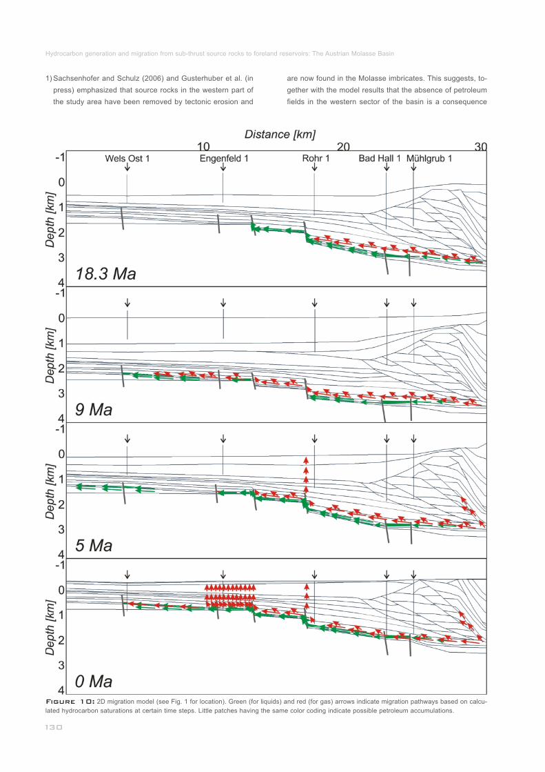
Figure 10: 2D migration model (see Fig. 1 for location). Green (for liquids) and red (for gas) arrows indicate migration pathways based on calcu-
lated hydrocarbon saturations at certain time steps. Little patches having the same color coding indicate possible petroleum accumulations._________
1) Sachsenhofer and Schulz (2006) and Gusterhuber et al. (in
press) emphasized that source rocks in the western part of
the study area have been removed by tectonic erosion and
are now found in the Molasse imbricates. This suggests, to-
gether with the model results that the absence of petroleum
fields in the western sector of the basin is a consequence
Hydrocarbon generation and migration from sub-thrust source rocks to foreland reservoirs: The Austrian Molasse Basin

Figure 11: Depth structure maps representing Upper Cretaceous and Eocene carrier/reservoir horizons. The (dotted) 0.6 % Ro iso-reflectivity re-
presents a rough assessment of the oil kitchen boundary. Bright green traces and batches show possible simulated oil migration pathways and accu-
mulations, respectively. Petroleum fields and fault patterns (white lines) are shown in each horizon._________________________________________
2)
These results look plausible but however some uncertainties
have to be considered. Although the best resolution available
from the 3D seismic volume was used, parts off the 3D cove-
rage were interpolated and may be too smooth to chase the
exact location of reservoirs. Another uncertainty may be caused
by the fact that present day but not paleo maps were used.
Present day maps are only able to show the actual migration,
not migration at the time of initiation. In addition, important
factors like facies behaviors and pressure regimes are not
considered in these migration models. Unfortunately, existing
data of the area which includes the oil kitchen is very sparse.
3D seismic data is limited to the foreland and there are only a
few wells drilled in this part. However, this preliminary work
provides a proper basement for further studies.
Fig. 12a shows a plot of API gravity of Molasse oils versus
depth. The plot indicates that biodegraded oils, characterized
____________
5.3.4 Biodegradation Risk
are now found in the Molasse imbricates. This suggests, to-
gether with the model results that the absence of petroleum
fields in the western sector of the basin is a consequence
of missing charge rather than of missing structures.
Migration probably did not only occur within the major car-
rier beds, but seemingly also along major fault systems
______
___
Jürgen GUSTERHUBER, Ralph HINSCH, Hans-Gert LINZER & Reinhard F. SACHSENHOFER

by API grades <30, are restricted to shallow levels (<800 m
sub-sea) with present-day temperatures ≤50° (see also Gratzer
et al., 2011). At first sight the shallow threshold depth for bio-
degradation in the study area is astonishing, because bacte-
ria responsible for biodegradation are known to occur up to
80°C (e.g. Head et al., 2003).
The lack of biodegraded oil at greater depth may be explai-
ned by the ‘palaeopasteurization’ model (Wilhelms et al., 2000),
postulating that petroleum reservoirs were pasteurized at 80-
90°C, inactivating any hydrocarbon-degrading microorganisms
present, during deep burial before the main oil charge and
subsequent uplift of the reservoir to cooler conditions.
The 2D model is used to test the applicability of the ‘palaeo-
pasteurization’ model in the Alpine Foreland Basin. In Fig. 12b
the position of the 80°C isotherm along the northern sector of
the modeled cross-section is shown for the time of maximum
burial (9 Ma). Different grey shadings indicate the upward in-
creasing risk for biodegradation. In Fig. 12c the present day
situation is shown together with the paleo-80°C isotherm. The
depth interval between the paleo- and the present-day 80°C
isotherm has been affected by ‘palaeopasteurization’. The
present-day position of the paleo-80°C isotherm is at about 1
km below sea level fitting reasonable well with the observed
depth of biodegradation. Thus ‘palaeopasteurization’ may
have a positive effect on the preservation of hydrocarbons in
the Alpine Foreland Basin.
_________________________
_____
____________________________
Important to note, that the ‘palaeopasteurization’ model is
only applicable if most hydrocarbons migrated into shallow
reservoirs after maximum burial. Although some oil reached
petroleum traps in the northern part of the cross-section (e.g.
Wels Ost 1) already during maximum burial (9 Ma), Figure 10
shows that additional oil accumulated during (5 Ma) and after
uplift (present-day).
The presented structural model is a kinematic model with
geodynamic background and provides an appropriate input
for the petroleum systems model. It supposes that total tec-
tonic shortening in the modeled section is at least 48.5 km
which corresponds to 69 % of shortening (mainly in the Mo-
lasse sediments, including some limited shortening in the
Penninic-Flysch and Helvetic wedge but excluding shorte-
ning of the Northern Calcareous Alps).
Maturity data indicate rather low paleo-heat flows along
the modeled section decreasing from north to south from 232 to 26 mW/m (base case `paleo´). Formation tempera-
tures indicate present-day basal heat flows decreasing in 2the same direction from 52 to 37 mW/m (case `recent´).
Consequently, a heat flow scenario which involves a sub-
recent (~4 Ma BP) increase in heat flow from base case
`paleo´ to base case `recent´ is accepted as most likely.
This heat flow history is similar to that reconstructed for a
__________________________________
________________
6 Conclusions
Figure 12: (a) Plot of API gravity of Molasse oils versus depth. Biodegraded oils with low API grades occur at shallow depth (above 800 m sub-
sea) corresponding to present formation temperatures of about 50 °C. (b) Modeled 80°C isotherms in the northern part of the 2D section for the time
of maximum burial (9 Ma). Grey shading indicates the upward increasing biodegradation risk. (c) Modeled 80°C isotherms in the northern part of the
2D section for present-day (0 Ma). The position of the paleo-80°C isotherm is also shown.________________________________________________
Hydrocarbon generation and migration from sub-thrust source rocks to foreland reservoirs: The Austrian Molasse Basin

parallel cross-section through the Perwang imbricates (~90
km west of the present cross-section) by Gusterhuber et
al. (in press).
The above heat flow history and bulk kinetic data from Oli-
gocene source rocks have been used for petroleum sys-
tems modeling. According to these models, hydrocarbon
generation commenced at about 18 Ma (Early Miocene)
due to deep burial beneath Alpine nappes and was termi-
nated about 8 Ma (Late Miocene) due to cooling caused
by uplift and erosion. Whereas the sub-thrust area bene-
ath the Flysch wedge remained immature, about 40 % of
the total source potential was realized beneath the Northern
Calcareous Alps in the Molln 1 area.
Hydrocarbon migration commenced contemporaneously
with hydrocarbon generation, but continued until present
day. Main model results include: (1) Oil migrated along the
source rock interval till it reached faults with sufficient ver-
tical throw to allow hydrocarbon migration into stratigraphi-
cally deeper reservoir units; (2) Long-distance (>50 km),
lateral, northward migration of oil (and gas); (3) Migration
of gas along fault zones into the Sierning imbricates; (4)
Apparent vertical diffusive migration of gas into the Oligo-
/Miocene Puchkirchen and Hall formations.
Detected and producing hydrocarbon deposits in Cenomani-
an and Eocene horizons (e.g. Malzer et al., 1993), oil seeps
along the northern basin margin (Gratzer et al., 2012), mix-
tures of biogenic and thermogenic gas in the Sierning imbri-
cates and the Puchkirchen and Hall formations (Reischen-
bacher and Sachsenhofer, 2011) show that the model re-
sults fit well with observations.
A flow path approach for modeling migration pathways in
the main carrier/reservoir units (‘Pseudo 3D Model’) pro-
duces ambiguous results. Whereas some major petroleum
fields are successfully predicted, others are not. Moreover,
accumulations are predicted in areas, where no hydrocar-
bons have been detected yet. Apart from model simplifica-
tions, the mismatch reflects the absence of source rocks in
the western part of the study area (e.g. Sachsenhofer and
Schulz, 2006) as well as the important role of fault zones
for hydrocarbon migration.
The applied 2D model suggests that deep burial (9 Ma)
and subsequent uplift to cooler conditions (Gusterhuber et
al., 2012) resulted in ‘palaeopasteurization’ of reservoirs
near the northern basin margin. This model may explain
that biodegradation in the Austrian part of the Alpine Fore-
land Basin is limited to the depth interval down to 800-
1000 m sub-sea.
The authors thank RAG AG for their kind permission to pub-
lish the data. The used software PetroMod was generous gran-
ted as academic license by the Schlumberger Technology Cen-
ter, Aachen, Germany. We would also like to thank Doris Gross,
Reinhard Gratzer and Achim Bechtel (Montanuniversität Leo-
ben) for providing a wealth of appropriate geochemical data.
__________________
____________
______________________
__________________________
_
Acknowledgements
References
Baur, F., 2010.
Beidinger, A. and Decker, K., submitted.
Bernhardt, A., Stright, L. and Lowe, D.R., 2012.
Burnham, A.K., 1989.
Carr, A.D, 2000.
Covault, J.A., Hubbard, S.M, Graham, S.A, Hinsch, R. and
Linzer, H.-G., 2009.
De Ruig, M.J. and Hubbard, S.M., 2006.
Dohmann, L., 1991.
Espitalié, J., LaPorte, J.L., Madec, M., Marquis, F., Leplat, P.,
Poulet, J. and Boutefeu, A., 1977.
Frisch, W., Kuhlemann, J. and Dunkl, I., 2001.
Genser, J., Cloetingh, S.A.P.L., Neubauer, F., 2007.
Glotzbach, C., Spiegel, C. Reinecker, J., Rahn, M. and Frisch,
W., 2009.
Quantification of heat and fluid flow through
time by 3D modeling: an example from the Jeanne d’Arc basin,
offshore eastern Canada. PhD thesis, RWTH Aaachen, 170 p.
Quantifying Early Mio-
cene in-sequence and out-sequence thrusting at the Alpine-
Carpathian junction. Tectonics.
Channellized
debris-flow deposits and their impact on turbidity currents: the
Puchkirchen axial channel belt in the Austrian Molasse Basin.
Sedimentology, 59, 7, 2042-2070.
A simple kinetic model of petroleum for-
mation and cracking. Lawrence Livermore National Laboratory
Report, UCID-21665, 11 p.
Suppression and retardation of vitrinite reflec-
tance, part 1. Formation and significance for hydrocarbon ge-
neration. Journal of Petroleum Geology, 23, 313–343.
Turbidite-reservoir architecture in comp-
lex foredeep-margin and wedge-top depocenters, Tertiary Mo-
lasse foreland basin system, Austria. Marine and Petroleum
Geology, 26, 379-396.
Seismic facies and
reservoir characteristics of a deep marine channel belt in the
Molasse foreland basin. AAPG Bulletin, 90, 735-752.
Die unteroligozänen Fischschiefer im Mo-
lassebecken. Ph.D. thesis, Ludwig Maximilian Universität, Mu-
nich, 365 pp.
Méthode rapide de charac-
tériasation des roches mères de leur potential pétrolier et de
leur degré d´evolution. Revue de l´Institut Francais du Pétrole,
32, 23-42.
The Dachstein
paleosurface and the Augenstein Formation in the Northern
Calcareous Alps – a mosaic stone in the geomorphological
evolution of the Eastern Alps. International Journal of Earth
Sciences, 90, 500-518.
Late oro-
genic rebound and oblique Alpine convergence: New con-
straints from subsidence analysis of the Austrian Molasse
basin. Global and Planetary Change, 58, 1-4, 214-223.
What perturbs isotherms? An assessment using
fission-track thermochronology and thermal modelling along
the Gotthard transect, Central Alps. Geological Society of Lon-
don, Special Publications, 324, 111-124.
_________________________
______________________
____________________________
______
_______
_______________________________
_____
__________________
Jürgen GUSTERHUBER, Ralph HINSCH, Hans-Gert LINZER & Reinhard F. SACHSENHOFER

Gratzer, R., Bechtel, A., Sachsenhofer, R.F., Linzer, H.-G., Rei-
schenbacher, D. and Schulz, H.-M., 2011.
Gratzer, R., Schmid, C. and Stanzel, A.I., 2012.
Grunert, P., Soliman, Coric A., S. Rötzel, R. Harzhauser, M.
and Piller, W.E., 2012.
Grunert, P., Hinsch, R., Sachsenhofer, R.F., Bechtel, A., Coric,
S., Harzhauser, M., Piller, W.E. and Sperl, H., 2013.
Gusterhuber, J., Dunkl, I., Hinsch, R. Linzer, H.-G. and Sach-
senhofer, R.F., 2012.
Gusterhuber, J., Hinsch, R. and Sachsenhofer, R.F., in press.
Hantschel, T., Kauerauf, A., Wygrala, B., 2000.
Hantschel, T. and Kauerauf, A., 2009.
Head, I.M., Jones, D.M. and Larter, S.R., 2003.
Hermanrud, C., Cao, S. and Lerche, I., 1990.
Hinsch, R., 2008.
Hinsch, R. and Linzer, H.-G., 2010.
Oil-oil and oil-source
rock correlations in the Alpine Foreland Basin of Austria: In-
sights from biomarker and stable carbon isotope studies. Ma-
rine and Petroleum Geology, 28, 1171-1186.
Bewertung
und Abgrenzung eines natürlichen Ölaustrittes im Eferdinger
Becken. Beiträge zur Hydrogeologie, 59, 203-217.
Facies development along the tide-in-
fluenced shelf of the Burdigalian Seaway: An example from
the Ottnangian stratotype (Early Miocene, middle Burdigalian).
Marine Micropaleontology, 84-85, 14-36.
Early Bur-
digalian infill of the Puchkirchen Trough (North Alpine Foreland
Basin, Central Paratethys): facies development and sequence
stratigraphy. Marine and Petroleum Geology, doi:http://dx.doi.
org/10.1016/j.marpetgeo.2012.08.009.
Neogene uplift and erosion in the Alpine
Foreland basin (Upper Austria and Salzburg). Geologica Car-
pathica, 63, 295-305.
Evaluation of hydrocarbon generation and migration in the
Molasse fold and thrust belt (Central Eastern Alps, Austria)
using structural and thermal basin models. AAPG Bulletin.
Finite element
analysis and ray tracing modeling of petroleum migration. Ma-
rine and Petroleum Geology, 17, 7, 815-820.
Fundamentals of Basin
Modeling. Springer Verlag, 425 p.
Biological ac-
tivity in the deep subsurface and the origin of heavy oil. Na-
ture, 426, 344-352.
Estimates of vir-
gin rock temperature derived from BHT measurement: Bias
and errors. Geophysics, 55 (7), 924-931.
New Insights into the Oligocene to Miocene
Geological Evolution of the Molasse Basin of Austria. Oil &
Gas European Magazine, 34 (3), 138-143.
Along-strike variations of
structural styles in the Imbricated Molasse of Salzburg and
Upper Austria: A 3D seismic perspective. European Geosci-
ences Union General Assembly, Geophysical Research Ab-
stracts, 12, EGU2010-4966-3.
______________
_________
_________________
___________________
__
______________
______________________
_________________
_______________
Hinsch, R., 2013.
Horner, D.R., 1951.
Horvath, F. and Cloetingh, S., 1996.
Hubbard, S.M., De Ruig, M.J. and Graham, S.A, 2005.
Hubbard, S.M., De Ruig, M.J. and Graham, S.A, 2009.
Jacob, H. and Kuckelkorn, K., 1977.
Kamyar, H. R., 2000.
Krenmayr, H. G., 1999.
Kuhlemann, J. and Kempf, O., 2002.
Linzer, H.-G., 2001.
Linzer, H.-G., 2002.
Linzer, H.-G., Decker, K., Peresson, H., Dell’Mour, R. and Frisch,
W., 2002b.
Linzer, H.-G., 2009.
Laterally varying structure and kinematics
of the Molasse fold and thrust belt of the Central Eastern Alps:
implications for exploration. AAPG Bulletin, 97, 10, 1805-1831.
Pressure buildup in wells, in: Brill, E.J.
(Ed.), Proceedings of the Third World Petroleum Congress.
The Hague Section II, Cologne, 503-521.
Stress-induced late-stage
subsidence anomalies in the Pannonian basin. Tectonophy-
sics, 266, 287-300.
Utili-
zing outcrop analogs to improve subsurface mapping of natu-
ral gas-bearing strata in the Puchkirchen Formation, Molasse
Basin, Upper Austria. Austrian Journal of Earth Sciences, 98,
52-66.
Confi-
ned channel-levee complex development in an elongate depo-
center: Deep-water Tertiary strata of the Austrian Molasse ba-
sin. Marine and Petroleum Geology, 26, 85-112.
The carbonization profile
of the Miesbach 1 well and its oil geological interpretation:
Erdöl-Erdgas-Zeitschrift, 93, 115-124.
Verteilung der Untergrundstemperaturen
an den Beispielen der Bohrlochtemperatur (BHT) – Messun-
gen in den RAG – Konzessionen Oberösterreichs und Salz-
burgs, (Molasse- und Flyschzone). PhD-thesis, University of
Vienna, Austria, 145 pp.
The Austrian sector of the North Al-
pine Molasse: A classic foreland basin. FOREGS (Forum of
Euopean Geological Surveys) Dachstein-Hallstatt-Salzkam-
mergut Region, Vienna, 22-26.
Post-Eocene evolution
of the North Alpine Foreland Basin and its response to Alpine
tectonics. Sedimentary Geology, 152, 45-78.
Cyclic channel systems in the Molasse
foreland basin of the Eastern Alps - the effects of Late Oligo-
cene foreland thrusting and Early Miocene lateral escape.
AAPG Bulletin, 85, 118 (abstract).
Structural and stratigraphic traps in chan-
nel systems and intraslope basins of the deep-water molasse
foreland basin of the Alps. AAPG 2002 Annual Convention &
Exhibition, Houston, Texas.
Balancing lateral orogenic float of the Eastern Alps.
Tectonophysics, 354, 211 –237.
Gas in Imbricated Channel Systems of
the Foreland Basin of the Eastern Alps (Austria). AAPG 2008
Annual Convention & Exhibition San Antonio, Texas.
________________
___________
___________________
_________________________
______________
______________________
____________________________
_________________________
_______
Hydrocarbon generation and migration from sub-thrust source rocks to foreland reservoirs: The Austrian Molasse Basin

Linzer, H.-G. and Sachsenhofer, R.F., 2010.
Mackenzie, A.S., Patience, R.L., Maxwell, J.R., Vandenbroucke,
M. and Durand, B, 1980.
Mackenzie, A.S., Hoffman, C.F. and Maxwell, J.R., 1981.
Mackenzie, A.S. and McKenzie, D., 1983.
Majorowicz, J. and Wybraniec, S. 2011.
Malzer, O., Rögl, F., Seifert, P., Wagner, L., Wessely, G. and
Brix, F., 1993.
Nachtmann, W., 1995.
Peters, K.E., Walters, C.C. and Moldowan, J.M., 2005.
Reischenbacher, D. and Sachsenhofer, R., 2011.
Röder, D. and Bachmann, G., 1996.
Rögl, F., 1998.
Rullkötter, J. and Marzi, R., 1989.
Rybach, L., 1984.
Submarine Large
Scale Mass Movements in the Deepwater Foreland Basin of
the Alps - Implications to Hydrocarbon Generation and Distri-
bution of Source and Reservoir Rocks. AAPG 2010 Annual
Convention & Exhibition New Orleans.
Molecular parameters of maturation in
the Toarcian shales, Paris basin, France - I: changes in the con-
figurations of acyclic isoprenoid alkanes, steranes and triter-
panes. Geochimica et Cosmochimica Acta, 44, 1709-1721.
Mo-
lecular parameters of maturation in the Toarcian shales, Paris
basin, France - III: changes in aromatic steroid hydrocarbons.
Geochimica et Cosmochimica Acta, 45, 1345-1355.
Isomerization and
aromatization of hydrocarbons in sedimentary basins formed
by extension. Geology Magazine, 120, 417-470.
New terrestrial heat
flow map of Europe after regional paleoclimatic correction appli-
cation. International Journal of Earth Sciences, 100, 881-887.
Die Molassezone und deren Untergrund. In: F.
Brix and O. Schultz (eds.), Erdöl und Erdgas in Österreich. Na-
turhistorisches Museum Wien und F. Berger, 281–358.
Fault-bounded structures as hydrocar-
bon traps in the upper Austrian Molasse Basin. Geologisch
Paläontologische Mitteilungen Innsbruck, 20, 221-230.
The ndbiomarker guide, 2 ed. Cambridge University Press, 1155 pp.
Entstehung
von Erdgas in der oberösterreichischen Molassezone: Daten
und offene Fragen. BHM, 156 (11), 463-468.
Evolution, structure and
petroleum geology of the German Molasse Basin, In: P. Zieg-
ler and F. Horvath, (eds.), Peri-Tethys Memoir 2, Structure
and Prospects of Alpine Basins and Forelands. Mèmoire du
Museum National d’Histoire naturelle, 170, 263-284.
Paläogeographic Considerations for Mediterra-
nean and Paratethys Seaways (Oligocene to Miocene). Anna-
len des Naturhistorischen Museums in Wien, 99A, 279–310.
New aspects of the appli-
cation of sterane isomerization and steroid aromatization to
petroleum exploration and the reconstruction of geothermal
histories of sedimentary basins. Reprint Division of Petroleum
Geochemistry, American Chemical Society, 34, 126-131.
The paleogeothermal conditions of the Swiss
Molasse Basin: Implications for hydrocarbon potential. Rev.
Institut Francais Du Petrole, 39, 143-146.
___________________
__
________
___________
______
_____
______________
________
_
____
________________
Sachsenhofer, R. F., 2001.
Sachsenhofer, R.F. and Schulz, H.-M., 2006.
Sachsenhofer, R.F., Leitner, B., Linzer, H.-G., Bechtel, A., Coric,
S., Gratzer, R. Reischenbacher, D. and Soliman, A., 2010.
Sachsenhofer, R.F, Linzer, H.-G., Bechtel, A., Dunkl, I. Grat-
zer, R., Gusterhuber, J., Hinsch, R. and Sperl, H., 2011.
Schegg, R., 1994.
Schegg, R. and Leu, W., 1996.
Schegg, R., Leu, W., Cornford, C. and Allen, P. A., 1997.
Schmidt, F. and Erdogan, L. T., 1993.
Schmidt, F. and Erdogan, L. T., 1996.
Schulz, H.-M., Sachsenhofer, R.F., Bechtel, A., Polesny, H.
and Wagner L., 2002.
Schulz. H.-M., Bechtel, A., Rainer, T., Sachsenhofer R.F. and
Struck, U., 2004.
Syn- and post-collisional heat flow
in the Cenozoic Eastern Alps: International Journal of Earth
Sciences, 90, 579-592.
Architecture of
Lower Oligocene source rocks in the Alpine Foreland Basin: a
model for syn- and post-depositional source - rock features in
the Paratethyan realm. Petroleum Geoscience, 12, 363-377.
De-
position, Erosion and Hydrocarbon Source Potential of the Oli-
gocene Eggerding Formation (Molasse Basin, Austria). Austri-
an Journal of Earth Sciences, 103, 76-99.
Influ-
ence of Alpine Tectonics on Source Rock Distribution, Hydro-
carbon Generation and Migration in the Austrian Part of the
Molasse Basin. AAPG 2011 International Conference and Ex-
hibition, Milan, Italy.
The coalification profile of the well Weggis
(Sub-alpine Molasse, Central Switzerland): Implications for
erosion estimates and the paleogeothermal regime in the ext-
ernal part of the Alps. Bulletin Swiss Association of Petroleum
Geol. and Engineers, 61, 57-67.
Clay mineral diagenesis and
thermal history of the Thonex well, western Swiss Molasse
Basin. Clays and Clay Minerals, 44 (5), 693-705.
New
coalification profiles in the Molasse Basin of Western Switzer-
land: Implications for the thermal and geodynamic evolution of
the Alpine Foreland. Eclogae Geologicae Helvetiae, 90, 79-96.
Basin modelling in an
overthrust area of Austria.In: A.G. Doré, E. Holter, J.H. Augus-
tson, W. Fjeldskaar, S. Hanslien, Ch. Hermanrud, B. Nyland,
D. J. Stewart and O. Sylta, (eds.), Basin Modelling: Advances
and Applications. NPF Special Publications, 3, 573-581.
Paleohydrodynamics in
exploration. In: W. Liebl and G. Wessely, (eds.), Petroleum ex-
ploration and production in thrust belts, foreland basins and
orogenic basins. European Association of Petroleum Geolo-
gists Special Publications, 5, 255-265.
Origin of hydrocarbon source rocks in
the Austrian Molasse Basin (Eocene-Oligocene transition).
Marine and Petroleum Geology, 19, 683-709.
Paleoceanography of the western central
paratethys during nannoplankton zone NP 23. The Dynow
Marlstone in the Austrian Molasse Basin. Geologica Carp-
thica, 55, 311-323.
______________________________
_
________________
__________________________________
________________________
__________
_____
__________________
_____________
Jürgen GUSTERHUBER, Ralph HINSCH, Hans-Gert LINZER & Reinhard F. SACHSENHOFER

Schulz, H.-M. and van Berk, W., 2009.
Schulz, H.-M., van Berk, W., Bechtel, A., Struck, U. and Faber,
E., 2009.
Sissingh, W., 1997.
Steininger, F.F., Wessely, G., Rögl, F. and Wagner, L., 1986.
Sweeney, J.J. and Burnham, A.K., 1990.
Teichmüller, R. and Teichmüller, M., 1986.
Tissot, B.P. and Welte, D.H., 1984.
van Husen, D., 1987.
Veron, J., 2005.
Wagner, L.R., 1996.
Wagner, L.R, 1998.
Welte, D. H. and Yukler, M. A., 1981.
Welte, D. H. and Yalcin, M.N., 1988.
Bacterial methane in
the Atzbach-Schwanenstadt gas field (Upper Austrian Molas-
se Basin), Part II: Retracing gas generation and filling history
by mass balancing of organic carbon conversion applying hy-
drogeochemical modelling. Marine and Petroleum Geology,
26, 1180-1189.
Bacterial methane in the Atzbach-Schwanenstadt
gas field (Upper Austrian Molasse Basin), Part I: Geology: Ma-
rine and Petroleum Geology, 26, 1163-1179.
Tectonostratigraphy of the North Alpine
Foreland Basin: Correlation of Tertiary depositional cycles
and orogenic phases. Tectonophysics, 282, 223-256.
Tertiary sedimentary history and tectonic evolution of the Eas-
tern Alpine foredeep. Giornale di Geologia Bologna, 48 (3),
285-297.
Evaluation of a simple
model of vitrinite reflectance based on chemical kinetics. AAPG
Bulletin, 74, 1559-1570.
Relations between
coalification and paleogeothermics in variscan and alpidic fore-
deeps of western Europe. Lecture Notes in Earth Sciences, 5,
53-80.
Petroleum Formation and ndOccurrence. 2 ed., Springer-Verlag, Berlin, 699 pp.
Die Ostalpen in den Eiszeiten. Populär-
wissenschaftliche Veröffentlichungen der Geologischen Bun-
desanstalt, Vienna, Map, scale 1:500,000.
The Alpine Molasse Basin – Review of petro-
leum geology and remaining potential. Bulletin für Angewandte
Geologie, 10, 75-86.
Stratigraphy and hydrocarbons in the Up-
per Austrian Molasse Foredeep (active margin). In: G. Wes-
sely and W. Liebl (eds.), Oil and Gas in Alpidic Thrustbelts
and Basins of Central and Eastern Europe. EAGE Special
Publications, 5, 217-235.
Tectono-stratigraphy and hydrocarbons in
the Molasse foredeep of Salzburg, Upper and Lower Austria.
In: A. Mascle, C.Puigdefàbregas, H.P.Luterbacher and M.Fer-
nandez (eds.), Cenozoic Foreland Basins of Western Europe.
Geological Society, Special Publications, 134, 339-369.
Petroleum origin and
accumulation in basin evolution - A quantitative model. AAPG
Bulletin, 65, 1387-1396.
Basin modelling - A new
comprehensive method in petroleum geology. Organic Geo-
chemistry, 13, 141-151.
______________
______
_______
________________
_____________________________
_____
______________________________
______________________________
Welte, D. H., Horsfield, B. and Baker, D.R., 1997.
Wessely, G., 1983.
Wilhelms, A., Larter, S.R., Head, I., Farrimond, P., di-Primio,
R. and Zwach, C., 2000.
Wygrala, B., 1988.
Wygrala, B., 1989.
Petroleum
and Basin Evolution. Springer Verlag, 535 p.
Zur Geologie und Hydrodynamik im süd-
lichen Wiener Becken und seiner Randzone. Mitteilungen der
österreichischen Geologischen Gesellschaft, 76, 27-68.
Biodegradation of oil in uplifted ba-
sins prevented by deep-burial sterilisation. Nature, 411, 1034-
1037.
Integrated computer-aided basin modeling
applied to analysis of hydrocarbon generation history in a Nor-
thern Italian oil field. Organic Geochemistry, 13, 187-197.
Integrated study of an oil field in the sou-
thern Po Basin, northern Italy. PhD thesis, University of Co-
logne, 226pp.
______________
_____
____
Received: 16 October 2013
Accepted: 12 December 2013
1)2)*) 3)4)Jürgen GUSTERHUBER , Ralph HINSCH , Hans-Gert 3) 1)LINZER & Reinhard F. SACHSENHOFER _____________
1)
2)
3)
4)
*)
Montanuniversität Leoben, Department Applied Geosciences and Geo-
physics, Chair of Petroleum Geology, Peter-Tunner-Straβe 5, A-8700
Leoben, Austria;
Present address: SANTOS Ltd., 60 Flinders Street, Adelaide SA
5000, Australia;
RAG Rohöl-Aufsuchungs Aktiengesellschaft, Schwarzenbergplatz 16,
A-1015 Vienna, Austria;
Present address: OMV Exploration & Production GmbH, Trabrenn-
straβe 6-8, 1020 Vienna;
Corresponding author, [email protected]
___________________________________
__________
Hydrocarbon generation and migration from sub-thrust source rocks to foreland reservoirs: The Austrian Molasse Basin
Top Related