ZONING ORDINANCE LEXINGTON, TENNESSEE · Title - This Ordinance shall be known and may be cited as...
182
ZONING ORDINANCE LEXINGTON, TENNESSEE As Updated September 2012
-
Upload
hoangkhuong -
Category
Documents
-
view
215 -
download
1
Transcript of ZONING ORDINANCE LEXINGTON, TENNESSEE · Title - This Ordinance shall be known and may be cited as...
ZONING ORDINANCE
LEXINGTON, TENNESSEE
As Updated September 2012

Prepared
by the
LEXINGTON PLANNING COMMISSION
Assisted by the
TABLE OF CONTENTS
Page
CHAPTER I GENERAL PROVISIONS RELATING TO ZONING 1
CHAPTER II GENERAL PROVISIONS 2
CHAPTER III DEFINITIONS 10
CHAPTER IV ESTABLISHMENT OF DISTRICTS 27
CHAPTER V PROVISIONS GOVERNING RESIDENTIAL DISTRICTS 28
CHAPTER VI PROVISIONS GOVERNING BUSINESS DISTRICTS 55
CHAPTER VII PROVISIONS GOVERNING INDUSTRIAL DISTRICTS 88
CHAPTER VIII PROVISIONS GOVERNING FLOOD DISTRICTS 99
CHAPTER IX SPECIAL PROVISIONS GOVERNING PARKING, LOADING, SIGNS, SITE PLAN REVIEW TEMPORARY STRUCTURES, PLANNED UNIT RESIDENTIAL DEVELOPMENTS ANDTELECOMMUNICATIONS 120
CHAPTER X PROVISIONS GOVERNING MOBILE HOME PARKS 171
CHAPTER XI ENFORCEMENT 178
CHAPTER XII BOARD OF ZONING APPEALS 180
CHAPTER XIII AMENDMENT 182
CHAPTER XIV LEGAL STATUS PROVISIONS 183
CHAPTER I
GENERAL PROVISIONS RELATING TO ZONING
AUTHORITY
An Ordinance, in pursuance of the authority granted by Section 13-7-201 through 13-7- 210 of the Tennessee Code Annotated, and for the purpose of promoting the public health, safety, morals, convenience, order, prosperity and general welfare; to provide for the establishment of districts or zones within the corporate limits of Lexington, to regulate within such districts the location, height, bulk, number of stories and size of buildings and other structures, the percentage of the lot which may be occupied, the sizes of yards, courts and other open spaces, the density of population, the uses of buildings, structures and land for trade, industry, residence recreation, public activities and other purposes; to provide methods of administration of this Ordinance and to prescribe penalties for the violation thereof.
BE IT ORDAINED BY THE BOARD OF MAYOR AND ALDERMEN OF LEXINGTON, TENNESSEE, AS FOLLOWS:
11-101. Title - This Ordinance shall be known and may be cited as the Zoning Ordinance of Lexington, Tennessee, and the map herein referred to which is identified by the title, "Official Zoning Map, Lexington, Tennessee" and all explanatory matters thereon and hereby adopted and made a part of this Ordinance. The Official Zoning Map shall be located in the City Hall and shall be identified by the signature of the Mayor attested by the City Clerk. The Official Zoning Map may be amended under the procedures set forth in Chapter XII of this Ordinance, provided, however, that no amendment of the Official Zoning Map shall become effective until after such change and entry has been made on said map and signed by the Mayor and attested by the City Clerk.
11-102. Purpose. - The zoning regulations and districts as herein set forth have been made in accordance with the comprehensive plan for the purpose of promoting the health, safety, morals, and the general welfare of the community. They have been designed to lessen congestion in the streets, to secure safety from fire, panic and other dangers, to provide adequate light and air, to prevent the overcrowding of land, to avoid undue concentration of population, to facilitate the adequate provision of transportation, water, sewerage, schools, parks and other public requirements.
They have been made with reasonable consideration among other things, as to the character of each district and its peculiar suitability for particular uses, and with a view of conserving the value of buildings and encouraging the most appropriate use of land throughout the city
CHAPTER II
GENERAL PROVISIONS
For the purpose of this Ordinance, there shall be certain general provisions which shall apply to the City as a whole as follows:
11-201. Zoning Affects Every Building and Use - No building or land shall hereafter be used and no building or part thereof shall be erected, moved or altered unless for a use expressly permitted by and in conformity with the regulations herein specified for the district in which it is located, except as hereinafter provided.
11-202. Continuance of Non-conforming Uses and Structures - It is the intent of this Ordinance to recognize that the elimination as expeditiously as is reasonable, of the existing buildings and structures or uses that are not in conformity with the provisions of this Ordinance is as much a subject of health, safety and welfare as is the prevention of the establishment of new uses that would violate the provisions of this Ordinance. It is also the intent of this Ordinance to administer the elimination of non-conforming uses, buildings and structures so as to avoid an unreasonable invasion of established private property rights. Lawful non-conforming uses, buildings and structures existing at the time of the passage of this Ordinance or any amendment thereto shall be allowed to remain subject to the following provisions:
A. A non-conforming building or building housing a non-conforming use shall not be
structurally altered except in conformance with the provisions of this Ordinance. This provision shall not be construed to prevent normal maintenance and repairs or alterations required for structural safety.
B. Any non-conforming building or non-conforming use, which is damaged by fire,
flood, wind or other act of God or man, may be reconstructed and used as before, if it be done within twelve (12) months of such damage, unless damage of the extent of more than seventy-five (75) percent of its fair sales value immediately prior to damage, in which case any repair or reconstruction shall be in conformity with the provisions of this Ordinance.
C. Except as provided in Chapter 279.1 of the 1973 Tennessee Acts, a non-
conforming use of land shall be restricted to the area occupied by such use as of the effective date of this Ordinance. A non-conforming use of a building or buildings shall not be enlarged to either additional land or buildings after the effective date of this Ordinance.
D. An existing non-conforming use of a building or land may be changed to a conforming use or to another non-conforming use of the same classification or a classification less detrimental to the district in which it is located.
E. No existing non-conforming use or structure shall be enlarged, extended,
constructed, reconstructed, moved, or structurally altered except as herein provided.
F. When a non-conforming use of any building or land has ceased for a period of
one (1) year, it shall not be re-established. G. Non-conforming commercials, business, or industrial uses created after the
passage of Tennessee Acts of 1973, Chapter 279.1 shall be allowed to expand operations and reconstruct facilities which involve an actual continuance and expansion of activities of the business which were permitted and being conducted prior to the change in zoning, provided that there is a reasonable amount of space for such expansion of the property owned by such business and that any construction, improvement or reconstruction shall be in conformance with the district requirements in which it is located.
11-203. Erection of More than One Principal Structure Per Lot - In any district, no more than one structure housing a permitted principal use may be erected on a single lot, except for multiple family dwellings, commercial structures, and industrial structures provided that the orientation of the structures conforms to the yard and other requirements of this Ordinance as though these structures were located on individual lots.
11-204. Reduction of Lot Area Prohibited - No lot even though it may consist of one or more adjacent lots of record shall be reduced in area so that yards, lot area per family, lot width, building area, or other requirements of this Ordinance are not maintained. This section shall not apply when a portion of a lot is acquired for a public purpose.
11-205. Required Yard Cannot Be Used by Another Building - No part of a yard or other open space required about any building for the purpose of complying with the provisions of these regulations shall be included as part of a yard or other open space required under these regulations for another building.
11-206. Rear Yard Abutting a Public Street - When the rear yard of a lot abuts a public street, all structures built in that rear yard shall observe the same setback from the street line, centerline of the street, or property line as required for adjacent properties which front on that street.
11-207. Corner Lots - On lots located at the intersection of two streets in residential districts, the frontage on both streets shall be considered as front yards, the other two yards shall be considered side yards for the purposes of this Ordinance.
11-208. Obstruction of Vision at Street Intersections Prohibited - No structure, planting, object, or sign which obstructs visibility shall be placed on a corner lot within the area defined by a distance of twenty-five (25) feet along the right-of-way lines of the intersecting streets from their point of intersection at the corner, and a line connecting the end points on the right-of-way lines to form an equilateral triangle, Any object between a height of two and one-half (2 1/2) feet and a height of ten (10) feet above the average grade of each street at the centerline thereof shall be deemed as obstructing vision under the provision of this Ordinance. The requirements of this section shall not be construed to prohibit any necessary retaining wall.
11-209. Access Control - In order to promote the safety of the motorist and pedestrian and to minimize traffic congestion and conflict by reducing the points of contact, the following regulations shall apply.
A. A point of access, i.e., drive or other opening for vehicles into a street shall not
exceed forty (40) feet in width. B. There shall be no more than two (2) points of access to any one (1) public street
on a lot of less than four hundred (400) feet but more than one hundred (100) feet in width. Lots less than one hundred (100) feet in width shall have no more than one (1) point of access to any one (1) public section.
C. No point of access shall be allowed within twenty-five (25) feet of the right-of-
way of any public street intersection. D. Where sidewalks exist, the area existing between the street and an interior
parking space or driveway parallel to the street shall have a curb of at least six (6) inches in height and six (6) inches in width separating the parking area from the sidewalk to prevent encroachment of vehicles onto the sidewalks area.
E. No curbs on city streets or rights-of-way shall be cut or altered without written
approval of the Building Inspector. F. Cases requiring variances relative to this Section, and hardships not caused by
the property owner, shall be heard and acted upon by the Board of Zoning Appeals, provided, further, that no curb cuts for off-street automobile storage of parking space shall be permitted where the arrangement would require that vehicles back directly into a public street.

G. Access control on property abutting state or federal highways shall be governed by official regulations of the Tennessee Department of Highways or the provisions of this Ordinance whichever is higher.
11-210. Street Frontage - No structure shall be erected on a lot which does not abut a public street or is located on a permanent access easement approved by the Lexington Planning Commission; all structures shall be located on lots as to provide safe and convenient access for servicing, fire protection, and required off-street parking.
11-211. Lot of Record - Where the owner of a lot of official record at the time of the adoption of this Ordinance does not own sufficient land to enable him to conform to the yard or other requirements of this Ordinance, an application may be submitted to the Board of Zoning Appeals for a variance from the terms of this Ordinance. Permission to use such lot as a building site may be granted, however, providing that the yards and other requirements of the districts are complied with as closely as is possible in the opinion of the Board of Zoning Appeals.
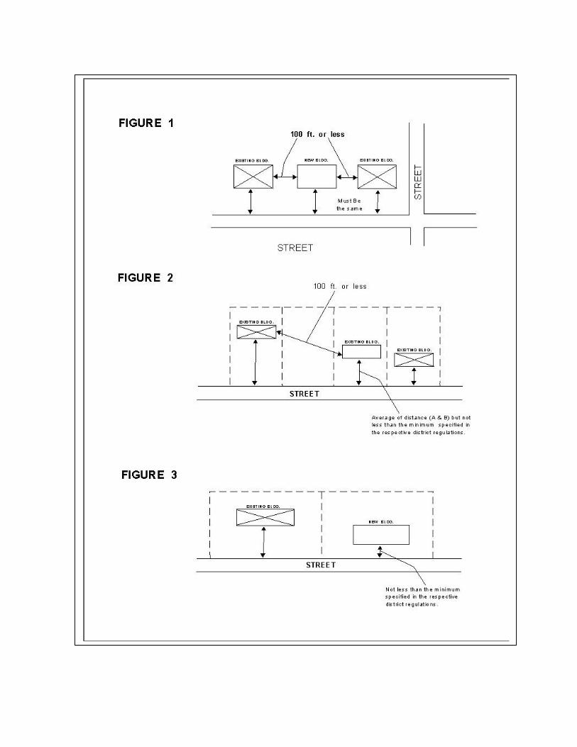
11-212. Front Yard Requirements in Pre-existing Developments - The front yard requirements established in the residential districts may be adjusted in situations where the enforcement of the yard requirements would create yard measurements different from those measurements existing for previously developed surrounding properties. The following diagrams illustrate the adjustments:
A. Where a new building will be constructed within 100' or less of existing buildings
with equal front yard setbacks, the required front yard for the new building shall be the same as that for the existing buildings. (Figure 1)
B. Where the new building will be constructed within 100' or less of existing
buildings with varying front yard setbacks, the required front yard for the new building shall be the average of the front yard setbacks of the existing buildings, but not less than the minimum specified in the respective district regulations. (Figure 2)
C. Where a new building will be constructed more than one hundred (100) feet
from the existing buildings, the required front yard for the new building shall not be less than the minimum specified in the respective district regulations. (Figure 3)
11-213. Front Yards - The front yard shall be measured from the street right-of- way. In the instance when the street right-of-way is unspecified, the following standards shall be used to establish a point of measurement:
A. Minor residential 50 foot right-of-way or 25 feet from the street centerline.
B. Collector streets 60 foot right-of-way or 30 feet from the street centerline.
C. Arterial streets 70 foot right-of-way or 35 feet from the street centerline.
11-214. Location of accessory activity, use, building or structure - No accessory activity, use, building, or structure shall be erected in any front or side yard except as provided for corner lots below, and no separate accessory activity, use, building or structure shall cover more than thirty (30) percent of any required rear yard, and shall be erected within five (5) feet from all lot lines and from any other buildings. For corner lots, accessory buildings or structures may be permitted in the side yards provided that no separate accessory activity, use, building or structure shall cover more than thirty (30) percent of the combination of required side yards and required front yards, and shall not be erected within the required front yard for principal structures or within five (5) feet from the side lot lines and from any other buildings except for fences and other uses specifically mentioned elsewhere in this ordinance.
In addition, all satellite dish antennae must comply with the following:
A. Such antennae may not exceed the highest ridgeline of the primary
structure on the property.
B. All installers of satellite dish antennae must obtain a building permit prior to the installation of such antennae.
C. In cases where the strict enforcement of this Section would impose an
undue practical hardship relative to the location of satellite dish antennae, the Board of Zoning Appeals shall review such cases and may issue the minimum locational variance required in keeping with the intent of this Section.
11-215. Fences, Walls and Hedges - Notwithstanding other provisions of this Ordinance, fences, walls, and hedges may be permitted in any required yard, or along the edge of any yard, provided that fences, walls, or hedges along the sides or front edge of any front yard be limited to a height of no more than 42 inches (3 ½ feet) with a setback of a minimum of 15 feet from the curb or the right of way whichever is
greater. Buffers may be exempt from these provisions if required by the reviewing authority. No proposed fence, wall, or fence shall be permitted, which violates Section 11-208 and any other provisions of this ordinance or other City Codes.
Neither fences, walls nor hedges shall be constructed within any known right-of-way, easement, or way. The requirements of this section shall not be deemed to prohibit any necessary retaining wall.
11-216. Interpretation of Permitted Uses - Permitted uses, when in question, shall be determined by utilization of the Standard Land Use Coding Manual. Uses will be considered similar if they are part of the same two digit code in the Standard Land Use Coding Manual.
11-217. Manufactured Residential Dwellings: In accordance with Tennessee Code Annotated Section 13-24-201, this Zoning Ordinance shall not be used to exclude the placement of a residential dwelling on land designated for residential use solely because the dwelling is partially or completely constructed in a manufacturing facility.” A structure, transportable in one or more sections, which may be built on a permanent chassis and designed to be used as a single family dwelling with a permanent foundation when connected to the required utilities, and includes the plumbing, hearing, air conditioning and electrical systems contained therein. For the purpose of these regulations, the term “manufactured residential dwellings” does not include “mobile home.” As herein defined and as further defined in Tennessee Code Annotated Section 13-24 –201. This term does not “apply to factory manufactured mobile homes constructed as a single self-contained unit and mounted on a single chassis…”
A. Manufactured Residential Dwellings
1. The unit must be installed on a continuous, permanent, masonry wall with the appearance of a conventional load-bearing foundation wall and appropriate venting and access in order to have a site- built appearance as allowed by Tennessee Code Annotated Section 13-24-202. Manufactured Residential Dwellings in Flood Hazard areas must comply with the requirements in Chapter VIII of this Ordinance.
2. The home must be covered with an exterior material customarily
used on conventional dwellings. Suitable exterior materials include but shall not be limited to clapboard, simulated clapboards, such as conventional or metal material, but excluding smooth, ribbed or corrugated metal or plastic panels.
3. The hitches or towing apparatus, axles and wheels must be removed.
4. The roof must be pitched so there is at least a 3.57 inch vertical
rise for each 12 inches of horizontal run. The roof must consist of material that is customarily used for conventional dwellings including but not limited to approved wood, asphalt composition shingles or fiberglass, but excluding corrugated aluminum, corrugated fiberglass or metal roof.
5. The unit must be oriented on the lot so that its long axis is parallel
with the street.
6. All such units shall be required to connect to a public utility system which includes, electricity, water and sewer in compliance with the Southern Standard Building Code, other national, state, and local codes.
11-218. Provisions Governing Setbacks from Underground Utility Lines and Mains or Utility Easements: No principal or accessory building or structure shall be erected within ten (10) feet of a utility easement, an underground sewer, water, gas, or other utility main except as provided for service connections. Exceptions shall be made for fences. Building permits may be denied by the building inspector in order to prevent any encroachment of any building, structure, or use into any recorded utility easement. The building inspector may require a stamped site plan for any proposed construction where there is existing utilities or evidence of possible underground utilities to prevent the encroachment of the construction because such construction obstructs maintenance, repair, replacement, or expansion of such utility facilities. The building inspector or utility personnel assume no responsibility for the location of such utilities and or easements. The proof or disproof of existing utilities or corresponding easements or right-of-way shall rest upon the property owner or his/her duly hired professional surveyor, engineer, or other related licensed professional.
CHAPTER III
DEFINITIONS
11-301. DEFINITIONS IN GENERAL
Except as specifically defined herein all words used in this Ordinance have their customary dictionary definitions where not consistent with the context of the Ordinance. The term "shall" is mandatory. Words used in the present shall include the future; the singular number shall include the plural and the plural the singular number; the word "building" shall include the word "structure". In case of conflict between building code or dictionary definitions with the definitions contained in this Ordinance, the definition herein shall prevail.
The categories established herein to define the permitted uses are derived from the Standard Land Use Coding Manual and adapted to the particular needs of the City of Lexington. The Standard Land Use Coding Manual, provided as an supplement of this Ordinance is intended to serve as a guide in the determination of what uses are permitted in all districts.
11-302. DEFINITIONS
Accessory Building, Structure and Use: A detached building or use subordinate to the principal building or use on the same lot and serving a purpose naturally and normally incidental to the principal building or use including swimming pools, fences, and satellite dishes.
Agriculture: See Code 81 of the Standard Land Use Coding Manual.
Agricultural Related Activities: See Code 82 of the Standard Land Use Coding Manual.
Alley: Any public or private way set aside for public travel, twenty (20) feet or less in width.
Amusement: An establishment which provides: arcade type entertainments including such items as pinball machines, video games and pool tables; miniature golf; or other amusements. (See Code 73 in the Standard Land Use Coding Manual)
Automobile Storage Yard: Any land use for the parking and/or storage of one or more abandoned or impounded operable vehicles for which compensation is received.
Billboards: See Signs - Off site.
Buffer Strip: A strip of land, established to protect one type of land use from another with which it is incompatible, which is landscaped and kept in perpetual open space uses.
Building: Any structure designed or built for the support enclosure, shelter or protection or persons, animals, chattels, or property.
Building, Height of: The vertical distance as measured from the finished grade at the front line of the building to the highest point of the structure.
Building Line - Front, Side, Rear: Lines which define the required area for the front, side and rear yards, as set forth in this Ordinance. This line is usually fixed parallel to the lot line and is equivalent to the required yard.
Building, Main or Principal: A building in which the primary use of the lot is conducted.
Building Official: The person designated to enforced the provisions of the Lexington Zoning Ordinance and other applicable city, state, or federal regulations relating thereto.
Business Service: An establishment which provide aid or merchandise to retail trade establishments including: advertising firms; consumer and mercantile credit reporting and collection firms; duplicating, mailing and stenographic services; dwelling and building cleaning services; photo finishing; and trading stamp service (see Code 63 in the Standard land use Coding Manual).
Canopy - An extension of the roof of a building or a freestanding structure that has a roof with support, but no walls.
Church: A building, together with its accessory buildings and uses, where persons regularly assemble for religious worship, and which building, together with its accessory building and uses, is maintained and controlled by a religious body organized to sustain public worship.
Clinic: Any establishment housing facilities for medical or dental diagnosis and treatment exclusive of major surgical procedures for patients who are not kept overnight on the premises (see codes 6511, 6512 and 6517 in the Standard Land Use Coding Manual).
Commercial: Activities related to the provision of products and services. See retail and wholesale trade; financial, business, personal and professional services.
Changeable Commercial Message Sign: An on premise reader board or off-premise advertising device which displays a series of messages at intervals by means of digital display or mechanical rotating panels.
Communication: See Code 47 in the Standard Land Use Coding Manual.
Condominium-Residential: A multi-family or townhouse development where the individual units are owned separately with common ownership of the land surrounding the development.
Cultural Activity: Any institution concerned with the appreciation of nature and the humanities such as but not limited to museums, art galleries, historic sites and aquariums (see Code 71 in the Standard Land Use Coding Manual).
Density: Number of units per acre allowed by this Zoning Ordinance.
District: Any section or sections of the City of Lexington for which the regulations governing the use of land and use, density, bulk, height, and coverage of buildings and other structures are uniform.
Driveway: A paved or graveled way, on private property, providing access from a public way, street or alley, to the main buildings, carport, garage, parking space or other portion of the premises.
Dwelling: A building or portion thereof which is designed for or used for human residential habitation. For the purpose of this Ordinance, the term "dwelling" shall not include boarding or rooming houses, motels, hotels, or other structures designed for transient residence.
Dwelling-Mobile Home: See Mobile Home
Dwelling, Multiple-Family: A building designed to be occupied by two (2) or more families, living independently of each other. Apartment buildings are considered multiple-family dwellings.
Dwelling, Single-Family: A detached residential dwelling unit other than a mobile home, designed for and occupied by one family only.
Dwelling, Two-Family: A building designed to be occupied by two families, living independently of each other and having only one wall common to both dwellings.
Dwelling, Townhouse: An attached residential dwelling unit for occupancy by one (1) family constructed in a row with each unit occupying at least (2) stories. Each dwelling unit is separated from the adjoining unit in each story by an adjoining fire resistant wall which has no openings in it and extends from the lowest floor through the roof with each dwelling unit having independent access to the exterior in the ground floor, (also see condominium, residential).
Dwelling Unit: One or more rooms designed as a unit for occupancy by one (1) family for cooking, living, and sleeping purposes, which is part of a two-family, or multi- family structures.
Education Services: Established schools including primary, secondary, universities, colleges, junior colleges and various private facilities such as correspondence schools and art, dance and music schools (see Code 68 in the Standard Land Use Coding Manual).
Elderly Assisted Care. A facility or development providing elderly care and housing, containing single rooms or other dwelling units which may consist of bedrooms, dinettes, and bathroom facilities, commonly containing group dining halls, recreational areas, and other communal areas provided that 24-hour medical care, medical staffing, and other services are required or provided.
Elderly Congregate Living. A facility or development providing elderly congregate group housing, containing individual dwelling units which may consist one or bedrooms, dining area, bathing and cooking facilities, or a combination thereof, provided that 24- hour medical care and medical staffing is not required or provided. For the purposes of this Ordinance, these types of facilities shall be classified as multifamily complexes and apartments.
Essential Services: The erection, construction, alteration, or maintenance by public utilities or municipal departments, or commissions, of underground or overhead gas, electrical, steam, or water transmission or distribution system, including poles, wires, mains, drains, sewers, pipes, conduits, cables, traffic signals, in connection therewith, but not including buildings or substations reasonably necessary for the furnishing of adequate services by such public utilities or municipal departments or commissions, or for the public health or safety or general welfare.
Exterior Boundary: See Exterior Yard.
Exterior Yard: A yard adjacent to the side or exterior boundaries of a mobile home park, a multi-family development or planned commercial development which is clear of any structures.
Factory Built Housing - A factory built structure designed for long term residential use. For the purposes of these regulations, factory built housing consist of three (3) types: modular homes, mobile homes and manufactured homes.
Family: One or more persons related by blood, marriage, or other legal arrangement, or a group of unrelated individuals, not to exceed two persons per bedroom of the house occupied, living as a single non-profit housekeeping unit.
Finance, Insurance and Real Estate Services: Those establishments which provide banking or bank related functions and insurance and real estate brokers. (See Code 61 in the Standard Land Use Coding Manual).
Garage, Private: A building or portion thereof for the storage of motor vehicles owned or used by the residents. Governmental Agency: An agency of the Federal, State, or the Local Government or any combination thereof.
Governmental Services: See Code 67 of the Standard Land Use Coding Manual.
Grade: The ground elevation used for the purpose of regulating the height of building. The ground elevation used for this purpose shall be the average of the finished ground elevations at the front line of the building.
Group Quarters: See Code 12 in the Standard Land Use Coding Manual.
Habitable Space: Areas within the building designed and/or used as living quarters for human beings.
Hazardous Substance: Any compound or use that can pose a substantial present or potential hazard to health or the environment when improperly treated, handled, stored, transported, disposed of or otherwise managed as defined by Section 68-27-102 of the Tennessee Code Annotated, or listed as hazardous or toxic by the Tennessee Department of Public Health or the U.S. Environmental Protection Agency.
Health Officer: The health officer of Henderson County.
Height: See Building, height of.
Incidental Home Occupation: A venture for profit which is incidentally conducted in a dwelling unit or accessory building as an accessory to the residential use.
Industry: See Manufacturing

Institution: A building occupied or operated by a non-profit society, corporation, individual foundation or governmental agency for the purpose of providing charitable, social, educational or similar services of a charitable character to the public.
Landscaping: A planted and maintained area of trees, shrubs, lawns, and other ground over or materials designated to present and aesthetic buffer between properties and adjoining uses or street areas.
Loading Space: An off-street space on the same lot with a building or group of buildings for temporary parking of a vehicle while loading and unloading merchandise or materials.
Lot: A legally recorded parcel of land.
Lot Area: The total horizontal area included within lot lines.
Lot, Corner: A lot abutting upon two (2) or more streets at their intersection. (See A in illustration 1)
Lot, Double Frontage: A lot having a frontage on two (2) non-intersecting streets as distinguished from a corner lot. (See C in illustration 1)
Illustration 1
Lot of Record: A parcel legally recorded in the Office of the Henderson County Register of Deeds prior to the date of the adoption of this Ordinance.
Lot Coverage: The lot area covered by all buildings located therein.
Lot Width: The horizontal measurement at the building line.
Manufacturing: The production of a product at a fixed site (see Code 21 through 39 in the Standard Land Use Coding Manual).
Medical Services: Those establishments which provide aid or merchandise relating to or concerned with the practice of medicine; excluding sanitariums, convalescent and rest home services. (See Code 651 in the Standard Land Use Coding Manual)
Mobile Homes: A factory-assembled, movable dwelling unit designed and constructed to be towed on its own permanent chassis, comprised of frame and wheels, to be used with or without a permanent foundation for permanent occupancy, but with the necessary service connections for required utilities, and distinguishable from other types of permanent dwellings in that the standards to which it is built include provisions for its mobility on that chassis as a vehicle.
The character of a mobile home as a non-permanent dwelling shall not be changed in the view of this Ordinance by removal of the wheels and/or carriage or placement on a permanent foundation. A travel trailer is not to be considered as a mobile home.
Mobile Home Park: Any plot of ground upon which three or more mobile homes are parked for occupancy as dwelling units provided that the land is maintained under single ownership.
Mobile Home Space. The term mobile home space shall mean a plot of ground within a mobile home park designated for the accommodation of one (1) mobile home.
Modular Home: A residential dwelling which is a structural unit or pre-assembled component unit including the necessary electrical, plumbing, heating, ventilating and other service systems, manufactured off-site and transported to the point of use for installation or erection, with or without other specified components, as a finished building and not designed for ready removal to another site.
Motor Vehicle Transportation: Transportation services including bus, taxi and motor freight transportation. (See code 42 of the Standard Land Use Coding Manual)
Non-Conforming Structure: A structure which was lawfully constructed prior to enactment or amendment to this Ordinance that does not conform with the provisions of this Ordinance for the district in which it is located.
Non-conforming Sign: A sign which lawfully existed prior to the adoption of the Lexington Zoning Ordinance and subsequent amendments but which no longer conforms to the regulations.
Non-conforming Use: Any use of building or premises which lawfully existed prior to the adoption of, or amendment of this Ordinance, but which no longer comply with the use regulations of the district in which it is located.
Noxious Matter: Material (in gaseous, liquid, solid, particulate, or any other form) which is capable of causing injury to living organisms by chemical reaction or is capable of causing detrimental effects upon the social, economic , or psychological well-being of individuals (also see toxic materials).
Nursery: Refers to the various arrangements made by parents for the care outside their home of children under seventeen (17) years of age, for less than 24-hour periods as provided in Tennessee Code Annotated, Section 14-1-101 through 14-10-105 as well as all pertinent rules regulations, and standards of the Tennessee Department of Human Services.
Nursery School: A building or structure used for the care of children as defined herein. Such a facility normally includes one of the following types.
(1) Family Day Care Home: A home operated by any person who receives pay for
providing less than 24-hour supervision and care, without transfer of custody, for 5, 6, or 7 children under 17 years of age, who are not residents of the household. A license is not required for a house providing care for fewer than 5 children.
(2) Group Day Care Home: Any place operated by a person, social agency,
corporation, institution, or other group which receives 8 to 12 children under 17 years of age, for less than 24 hours per day, for care outside their home, without transfer of custody. A group day care home may care for no more than 12 children.
(3) Day Care Center: A place operated by a person, social agency, corporation,
institution, or other group that receives pay for the care of 13 or more children under 17 years of age for less than 24 hours per day, without transfer of custody.
Parks: An open area set aside for leisure activities which is not used for the operation of a profit making venture, such as but not limited to playgrounds, athletic or playfields and picnic areas.
Parking Space: A paved and properly drained area, enclosed or unclosed, required by this Ordinance to be permanently reserved for parking one (1) motor vehicle.
Periphery Boundary: (See Exterior Yard)
Personal Services: Services which include laundry, beauty, funeral, and other services to individuals. (See Code 62 in the Standard Land Use Coding Manual).
Philanthropic Institution: An organization which distributes funds for humanitarian purposes or which is supported by public donations and which has as its principal activity the promotion of human welfare. This shall include, but not be limited to: civic clubs; organizations such as Lions, Moose, Elks, United Way, etc.
Principal Building: A building in which is conducted the primary use of the lot on which it is located.
Principal Use: The specific primary purpose for which land or a building is used.
Professional Services: Those services normally provided by the established professions such as, but not limited to, physician services, dental services, legal services, engineering services, architectural services and accounting services, not to include sanitariums, convalescent and rest home services. (See Code 65 in the Standard Land Use Coding Manual).
Public Assembly Facility: Any of the following types of institutions or installations where community activities are typically performed such as: parochial and private clubs, lodges, meeting halls, recreation centers and areas; temporary festivals; theaters; public, parochial and private museums and art galleries; places of worship, including any structure or site such as a church, synagogue, chapel, sanctuary or cathedral, used for collective or individual involvement with a religious activity, such as rites, rituals, ceremonies, prayer and discussion; public community centers and recreational areas such as playgrounds, playfields and parks.
Public Uses: Facilities such as, but not limited to parks, schools, and offices owned and operated by governmental bodies.
Public Utility: Any plant or equipment for the conveyance of telephone messages or for the production, transmission, delivery of, or furnishing of heat, chilled air, chilled water, light, power or water, or sewage facilities, either directly or indirectly to or for the public (see Codes 47 and 48 except Code 4823 and 485).
Real Estate Sign: A sign indicating that a parcel is for sale or rent. This shall include sold signs and signs that indicate that a parcel or structure has been sold through words such as "future home of company b".
Recreational Activities: Sports activity, playground and athletic areas, swimming areas, marinas and other similar activities. (See Code 74 of the Standard Land Use Coding Manual).
Recreational Vehicle: A trailer towed behind a car or a self propelled vehicle intended for use as a temporary recreational dwelling.
Repair Services: Those establishments which fix, mend or overhaul merchandise for households or businesses, not to include automobile body shops (See Code 64 in the Standard Land Use Coding Manual).
Retail Trade: Those establishment engaged in selling merchandise for personal or household consumption and rendering services incidental to the sale of goods. (See Code 52 through 59 in the Standard Land Use Coding Manual).
Schools, Parochial: An institution of learning owned and/or operated by a recognized church or religious institution.
Signs: Any device designed to inform, or attract the attention of persons which presents a name, symbol, logo or advertisement for services or products offered on or off-site as allowed under the regulations of this Ordinance. The term sign shall include the sign structure and all attachments, if attached to a structure, or ground mounted, shall include a base, poles, mounts or attachments from the ground level upward. For more specific definitions used in Section 11-907 see below.
Abandoned/Obsolete Sign - any sign which identifies or advertises a business, lessor, service, owner, product, or activity, which is no longer available at the indicated location or no longer available on the premises or for which no legal owner can be found.
Animated sign - A sign which uses movement or change of light to depict or to create a special effect or scene (does not include time, temperature or message signs).
Attached Business Sign - Any sign which is affixed directly to or otherwise inscribed or painted on a wall or parapet wall of any building or structure with the exposed face of the sign in a plane approximately parallel to the plane of such wall and extending therefrom less than twelve (12) inches.
Awning/Canopy Sign - A sign painted on, printed on, or attached flat against the surface of an awning or canopy projecting from and supported by the exterior wall of a building.
Banner Sign - A sign made of fabric or other nonrigid materials with no enclosing framework. National flags, state or municipal flags, or the official flag of any institution or business shall not be considered banners.
Business Identification Sign - A freestanding sign identifying a recognized firm, business, or service.
Construction Sign - A temporary sign identifying an architect, contractor, subcontractor, and/or material supplier participating in construction on the property on which the sign is located.
Directional/Informational Sign - Any on-premise sign giving directions, instructions, or facility information, e.g., parking or exit and entrance signs, and which may contain the name or logo of an establishment but no other advertising copy.
Developmental Services Officer - The city official or authorized representative charged with the responsibilities of enforcing the ordinance.
Flashing Sign - Any directly or indirectly illuminated sign which contains an intermittent flashing light source. (This does not include message center or time/temperature signs.)
Freestanding Sign - Any sign supported by uprights or braces placed on or in the ground and not attached to any building.
Ground Sign - Any sign supported by the ground with little or no vertical clearance.
Height (of a sign) - The vertical distance measured from the highest point of the sign, excluding decorative embellishments, to the grade of the adjacent street or the surface grade beneath the sign, whichever is less.
Illegal Sign - Any sign and/or advertising structure erected without a permit required by this Ordinance, or in violation of any of the limitations, prohibitions or requirements of this Ordinance.
Maintenance - For the purposes of this ordinance, the cleaning, painting, repair, or replacement of defective parts of a sign in a manner that does not alter the basic copy, design, or structure of the sign.
Mall Grouping Signs - Signs on one pole identifying a group of stores, businesses, or professional offices located in one development. These include office center signs and shopping center signs.
Message Board - A sign with changeable, removable letters to allow the user to replace or update the copy on the sign.
Nonconforming Sign - (a) Any sign which was erected legally but which does not comply with subsequently enacted sign regulations and restrictions; (b) A sign which does not conform to the Sign Code requirements but for which a variance has been issued. These signs are grandfathered provided they do not violate the provisions of Section G.2.
Off Premise Sign - A sign not located on the property that it advertises.
Office Center - Two or more offices having a common parking lot.
Political Sign - A sign displaying the name and/or picture of an individual seeking election to a public office or a sign otherwise relating to a forthcoming public election or referendum.
Portable Sign - Any sign which by its construction or nature may be or is intended to be freely moved from one location to another. When on a trailer, the removal of the wheels or undercarriage does not place the sign in another category, neither does the anchoring of the sign by means of concrete blocks, sandbags or other types of temporary anchors. Portable signs include, but are not limited to, signs designed to be transported by means of wheels; signs converted to A- or T-Frames; menu and sandwich board signs; balloons used as signs; umbrellas used for advertising.
Projecting Sign - Any sign, other than a flat wall sign, which is attached to and projects more than 12" from a building wall or other structure not specifically designed to support the sign.
Public Sign - Any temporary or permanent sign erected and maintained by the City, County, State or Federal Government for traffic direction or for the designation of or direction to any school, hospital, historical site, or public service, property or facility.
Real Estate Sign - Any temporary sign advertising the real estate upon which the sign is located as being for rent, lease or sale.
Roof Sign - Any sign erected, constructed or maintained wholly or partially upon or over the roof line of any building with the principal structural support on the roof or building structure.
Shopping Center - Two or more businesses sharing a common parking lot. This shall include indoor and outdoor malls.
Sign - Any object, device, graphic design or part thereof, situated outdoors or indoors and which object, device, graphic design or the effect produced is used to advertise, announce, identify, declare, demonstrate, display, instruct, direct or attract attention by any means including words, letters, figures, designs, fixtures, colors, motion, illumination, sound and projecting images. Any sign requiring a permit is considered to be a structure.
Sign Area - (a) Freestanding, Roof and Projecting Signs: The area enclosed by one continuous line, connecting the extreme points or edges of the sign. The area shall be determined using the largest sign area or silhouette, but excluding the necessary supports or uprights. Two-sided signs constructed back to back shall use the square footage of one side only for compliance. Three-sided signs with no more than 60 degrees between the faces shall be figured using one face only. (b) Attached Business, Awning and Canopy Signs: The area including all lettering, wording, and accompanying design or symbols together with any background. For a sign composed of individual letters or figures, the area is that of the smallest rectangle or other geometric shape that encompasses all the letters or symbols.
Sign Permit - A written permit granted by the Developmental Services Officer for the erection, construction, enlargement, relocation or conversion of any sign for which a permit is required.
Subdivision Identification Sign - A freestanding or wall sign identifying a recognized subdivision, condominium complex, or residential development.
Time and Temperature Sign - Electrically controlled public service time, temperature and date signs displayed on a lamp, bank or other electronic display.
Temporary Sign - Any sign, banner, pennant, valance or advertising display or sign constructed of light fabric, cardboard, wallboard, plywood, paper or other light materials, with or without frames, intended to be displayed for a limited period of time, i.e., garage sale, rummage, open house and similar types of signs.
Vehicle Mounted Sign - Any sign painted on or attached to a vehicle relating to the business, activity, use, service or product of the owner of the vehicle, or to the sale of the vehicle and which sign is incidental to the primary use of the vehicle.
Window Sign - Any on-premise business sign installed in or on a window and intended to be viewed from the outside.
Site Plan: A plan delineating the overall scheme of the development of a tract including all items as specified in this Ordinance.
Story: That portion of a building included between the upper surface of any floor and the upper surface of the floor next above; or any portion of a building used for human occupancy, between the topmost floor and the roof. A basement not used for human occupancy shall not be counted as a story.
"Half Story": A story under a slopping roof, the finished floor area which does not exceed one half the floor area of the floor immediately below it, or a basement used for a human occupancy, the floor area of the part of the basement thus used not to exceed fifty (50) percent of the floor area of the floor immediately above.
Street or Road: A way for vehicular traffic, whether the road is designed as an avenue, arterial, collector, boulevard, road, highway, street, expressway, lane, alley or other way, and for the purpose of these regulations "roads" are divided into the following categories.
(1) Arterial Street: A major street used primarily for heavy through traffic which
will be so designated on the Lexington Major Road Plan. (2) Collector Street: A street designed to carry traffic from minor streets to the
major road system including the principal entrance streets to a residential development and the streets for major circulation within such a development. Collector streets are usually designed as such on the Lexington Major Road Plan.
(3) Cul-de-sac or Dead-end Street: A local street with only one outlet for which
there are no plans for extension and no need for extension. (4) Marginal Access Street: A minor street which is constructed parallel and
adjacent to an arterial street for the purpose of providing access to abutting properties and protection from through traffic.
(5) Minor Residential or Local Streets: A neighborhood or commercial area
street used primarily for access to the abutting properties. Street Line: The property line which bounds the rights-of-way set aside for use as a street. Where sidewalks exist and the location of the property line is questioned, the
side of the sidewalk farthest from the traveled street shall be considered as the street line.
Street Center Lines: The center of the surface roadway or the surveyed center line of the street.
Temporary Structure: A moveable structure (anything constructed or erected) which either is not permanently attached to a permanent foundation, concrete slab or footing, or which is equipped with a permanent steel chassis.
"Total Floor Area": The area of all floors of a building including finished attics, finished basements, covered porches, and carports.
Toxic Materials: Material (gaseous, liquid, solid, particulate, or any other form) which is capable of causing injury to living organisms by chemical recreation even when present in relatively small amounts.
Transient Lodging: Temporary lodging as set forth in Code 15 of the Standard Land Use Coding Manual.
Travel Trailer: A travel trailer, pick-up camper, converted tent-trailer, tent, or similar device used for temporary portable housing of a unit which:
can operate independent of connections to external sewer, water and electrical systems;
contains water storage facilities and may contain a lavatory, kitchen sink and/or bath facilities; and/or
is identified by the manufacturer as a travel trailer.
Travel Trailer Park: The term "travel trailer park" shall mean any plot of ground within the Town of Lexington on which two (2) or more travel trailers, occupied by camping or periods not to exceed fourteen (14) days are located.
Usable Floor Area: Measurement of usable floor area shall be the sum of gross horizontal areas of the several floors of the building, measured from the interior faces of the exterior walls. Floor area which is used or intended to be used principally for the storage or processing of merchandise or for utilities shall be excluded from this computation.
Use: The special purpose for which land or a building is designed, arranged, intended, or for which it is or may be occupied or maintained. The term "permitted use" or its equivalent shall not be deemed to include any non-conforming use.
Uses Permissible on Appeal: A use allowed on appeal to the Board of Zoning Appeals.
Utilities: Gas, water, electricity, sewer and telephone services provided by government agencies or private companies (See code 48 in the Standard Land use Coding Manual).
Variance: A modification of the strict application of the area (lot, yard and open space) regulations and development standards of this Ordinance due to exceptionally irregular, narrow, shallow, or steep lots, whereby such strict application would result in practical difficulty or unnecessary hardship which would deprive an owner of reasonable use of the property.
The salient points of a variance are (1) undue hardship caused by exceptional physical irregularities of the property; and (2) unique circumstances due to the exceptional physical irregularities; and, (3) strict application of the area regulations and development standards which would deprive an owner of reasonable use of the property. A variance is not justified unless all three elements are present.
Veterinary Hospital or Clinic: Any establishment maintained and operated by a licensed veterinarian for the surgery, diagnosis and treatment of diseases or injuries of animals. Such an establishment may include accessory boarding facilities provided they are located within the building. (See Code 8221 and 8222 Standard Land Use Coding Manual).
Warehouse: A structure used exclusively for the storage of merchandise or commodities.
Wholesale Trade: Establishments or places of business primarily engaged in selling merchandise to retailer, to industrial, commercial, farm, or professional business users, or to other wholesalers, or acting as agents or brokers in buying merchandise for, or selling merchandise to such persons or companies. (See Code 51 in the Standard Land Use Coding Manual).
"Yards": Any open space on the same lot with a principal building open, unoccupied and unobstructed by building from the ground to the sky except as otherwise provided in this Ordinance. The measure of a yard shall be the minimum horizontal distance between any part of the principal building and lot or street right-of-way lines.
(1) "Front Yard": The yard extending across the entire width of the lot between
the front lot line, and the nearest part of the principal building. On corner lots, the yards adjacent to both streets shall be front yards. (See Illustration 2)
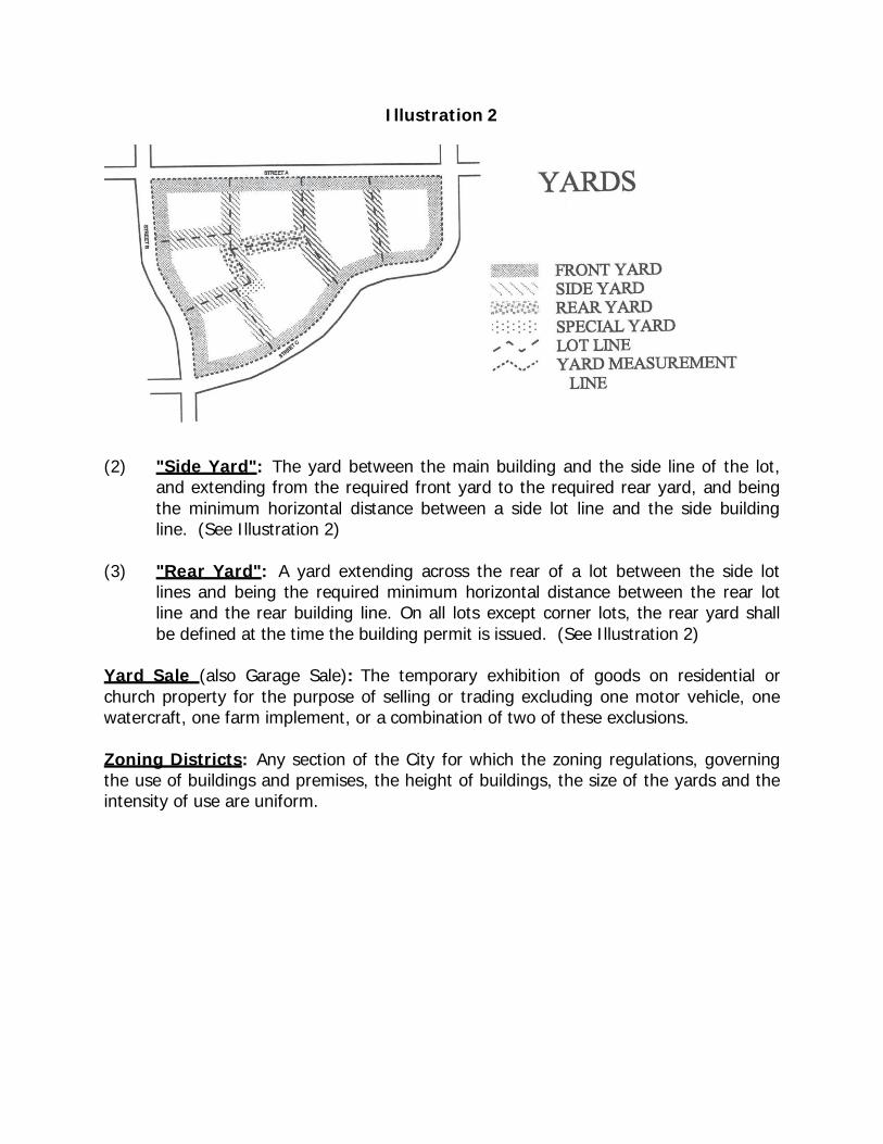
Illustration 2
(2) "Side Yard": The yard between the main building and the side line of the lot,
and extending from the required front yard to the required rear yard, and being the minimum horizontal distance between a side lot line and the side building line. (See Illustration 2)
(3) "Rear Yard": A yard extending across the rear of a lot between the side lot
lines and being the required minimum horizontal distance between the rear lot line and the rear building line. On all lots except corner lots, the rear yard shall be defined at the time the building permit is issued. (See Illustration 2)
Yard Sale (also Garage Sale): The temporary exhibition of goods on residential or church property for the purpose of selling or trading excluding one motor vehicle, one watercraft, one farm implement, or a combination of two of these exclusions.
Zoning Districts: Any section of the City for which the zoning regulations, governing the use of buildings and premises, the height of buildings, the size of the yards and the intensity of use are uniform.
CHAPTER IV
ESTABLISHMENT OF DISTRICTS
11-401. Classification of Districts - For the purpose of this Ordinance, Lexington, Tennessee, is hereby divided into fourteen (14) districts, designated as follows:
R-1 Low Density Residential R-2 Medium Density Residential R-3 High Density Residential R-4 High Density Mixed Structure Residential B-1 Neighborhood Business B-2 Intermediate Business B-3 Central Business B-P Planned Business H-M Hospital-Medical B-M Business-Industrial M-1 Light Industrial M-2 Heavy Industrial F-H (Flood Hazard) Districts Flood Fringe and Floodway
Sign District 11-402. Boundaries of Districts:
A. The boundaries of districts in Section 11-401 of this Chapter are hereby
established as shown on the Official Zoning Map entitled "Zoning Map of Lexington, Tennessee", which is a part of this Ordinance and which is on file in the City Hall.
B. Unless otherwise indicated on the zoning map, the boundaries are lot lines, the
center lines of streets or alleys, railroad rights-of-way, or the corporate limit lines as they existed at the time of the enactment of this Ordinance. Questions concerning the exact locations of district boundaries shall be determined by the Board of Zoning Appeals.
C. Where a district boundary divides a lot, as existing at the time this Ordinance
takes effect and the major portion of said lot is in the less restricted district, the regulations relative to that district may be extended to twenty (20) feet within the more restrictive district within said lot.
CHAPTER V
PROVISIONS GOVERNING RESIDENTIAL DISTRICTS
11-501. R-1 (Low Density Residential) Districts - The purpose of the low density district is to maintain the character of areas that currently exist or are suitable for the development of customary detached single family homes and accessory structures. These provisions have been devised to encourage adequate open space promoting emergency access as well as aesthetic quality while protecting these neighborhoods from unnecessary traffic congestion associated with greater population densities and more intense activities.
Within the R-1 (Low Density Residential) Districts, as shown on the Zoning Map of Lexington, Tennessee, the following regulations shall apply:
A. Uses Permitted.
1. Single-family dwellings excluding mobile homes on individual lots.
2. Accessory uses and buildings customarily incidental to any aforementioned
permitted uses such as private garages, parking areas, swimming pools, or recreation courts used exclusively by the residents.
3. Signs in accordance with Chapter IX of this Ordinance
B. Uses Permissible on Appeal.
1. Churches and other Places of Worship 2 Schools 3. Municipal, County, State or Federal uses 4. Libraries 5. Parks and Recreational facilities 6. Transportation right-of-ways 7. Public utilities facilities 8. Cemeteries 9. Nursing Homes and Elderly-Assisted Care Facilities
a. As a condition of approval of the aforementioned Uses Permissible
on Appeal, site plans shall be approved by the Board of Zoning Appeals in accordance with Chapter IX, Section 11-914 of this Ordinance. The Board of Zoning Appeals may attach such conditions to the permit as are necessary to minimize vehicle and pedestrian congestion and to preserve and protect the character of the district in which the proposed use is located. This power shall
include: the power to require greater setbacks and yard spaces than required by other provisions of this Ordinance, the power to specify access points and driveway and parking locations, and similarly site design matters. This power shall not include the power to specify or alter the architectural style of proposed buildings, the power to specify building materials or colors, or other similar powers.
10. Customary incidental home occupations provided that no building permit
or certificate of occupancy for such use shall be issued without the written approval of the Board of Zoning Appeals and subject to such conditions as the Board of Zoning Appeals may require in order to preserve and protect the character of the neighborhood in which the proposed use is located; and provided further that:
a. the proposed use shall be located and conducted in the principal
building only;
b. the principal and employees engaged in the proposed use shall be residents of the dwelling unit in which the proposed use is located;
c. not more than fifteen (15) percent of the total floor area in dwelling
unit shall be devoted to the proposed use;
d. the proposed use shall not constitute primary or incidental storage facilities for a business, industrial, or agricultural activity conducted elsewhere;
e. no activity, materials, goods, or equipment indicative of the
proposed use shall be visible from any public way;
f. the proposed use shall not be advertised by the display of goods or signs on the lot on which the proposed use is located;
g. the proposed use shall not generate noise, odor, fumes, smoke,
vehicular or pedestrian traffic, nor nuisance of any kind which would tend to depreciate the residential character of the neighborhood in which the proposed use is located;
h. the provisions of this section shall not be used under any
circumstances to permit beauty and barber services; gift, florist, antique shops or other retail shops; or medical and health services specifically due to the burdens of traffic, parking, and utility demands posed by these operations.
11. Family Care Centers, as defined in Chapter 3 under Nursery School, may be permitted by the Board of Zoning Appeals upon approval of a site plan which is drawn to scale and which addresses the criteria enumerated Chapter IX, Section 11-914. The approval and the site plan may be subject to such conditions as the Board of Zoning Appeals may require in order to preserve and protect the character of the district in which the proposed use is located. At a minimum, these operations approved shall meet the following requirements:
a. The family day care home be conducted in single family residences
only. Accessory structures may not be used for day care facilities.
b. Minimum required lot area;
(1) Family Day Care Home - 10,000 square feet.
c. Minimum required fenced play area.
(1) Family Day Care Home - 1,400 square feet.
d. The Board of Zoning Appeals shall also specifically address the need for set back of fenced play area and buffering of the fenced play area, and may require set back and/or buffering in specific cases to protect adjacent residential uses.
e. All outdoor play activities shall be conducted within the fenced play
area.
f. The day care facilities, maintenance and operation shall meet the requirements of the Tennessee Department of Human Services and any other applicable local, state, or federal regulations.
g. There shall be no signs advertising the property as a daycare
facility.
12. Telecommunications Equipment on Existing Structures Only may be permitted by the Board of Zoning Appeals upon approval of a proposal which addresses the criteria enumerated Chapter IX, Section 11-918. The approval and the site plan may be subject to such conditions as the Board of Zoning Appeals may require in order to preserve and protect the character of the district in which the proposed use is located. At a minimum, these operations approved shall meet the requirements in Chapter IX, Section 11-918.
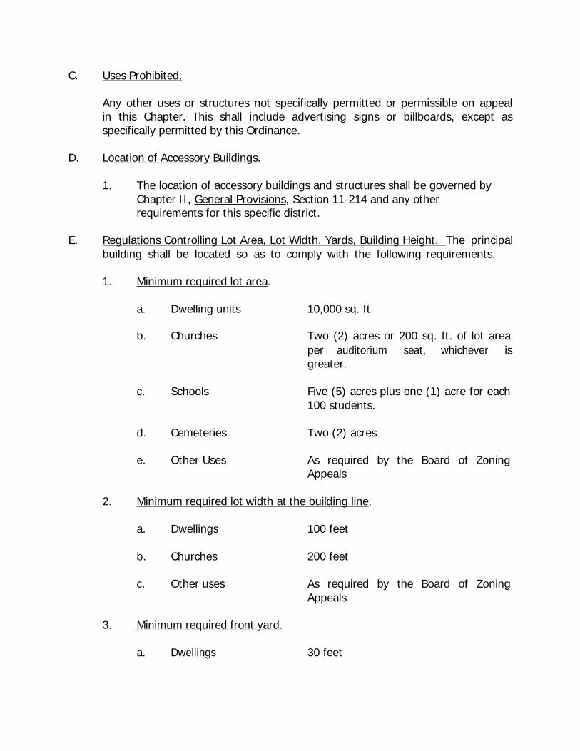
C. Uses Prohibited.
Any other uses or structures not specifically permitted or permissible on appeal in this Chapter. This shall include advertising signs or billboards, except as specifically permitted by this Ordinance.
D. Location of Accessory Buildings.
1. The location of accessory buildings and structures shall be governed by Chapter II, General Provisions, Section 11-214 and any other requirements for this specific district.
E. Regulations Controlling Lot Area, Lot Width, Yards, Building Height. The principal
building shall be located so as to comply with the following requirements.
1. Minimum required lot area.
a. b.
Dwelling units
Churches
10,000 sq. ft.
Two (2) acres or 200 sq. ft. of lot area per auditorium seat, whichever is
greater.
c. Schools Five (5) acres plus one (1) acre for each 100 students.
d. Cemeteries Two (2) acres
e. Other Uses As required by the Board of Zoning Appeals
2. Minimum required lot width at the building line.
a. Dwellings 100 feet
b. Churches 200 feet
c. Other uses As required by the Board of Zoning Appeals
3. Minimum required front yard.
a. Dwellings 30 feet
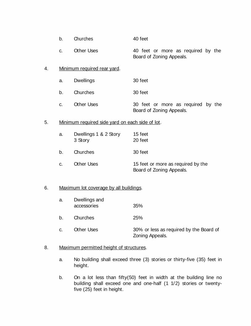
b. Churches 40 feet
c. Other Uses 40 feet or more as required by the Board of Zoning Appeals.
4. Minimum required rear yard.
a. Dwellings 30 feet
b. Churches 30 feet
c. Other Uses 30 feet or more as required Board of Zoning Appeals.
by the
5. Minimum required side yard on each side of lot.
a. Dwellings 1 & 2 Story 3 Story
15 feet 20 feet
b. Churches 30 feet
c. Other Uses 15 feet or more as required by the Board of Zoning Appeals.
6. Maximum lot coverage by all buildings.
a. Dwellings and accessories
35%
b. Churches 25%
c. Other Uses 30% or less as required by the Board of Zoning Appeals.
8. Maximum permitted height of structures.
a. No building shall exceed three (3) stories or thirty-five (35) feet in height.
b. On a lot less than fifty(50) feet in width at the building line no
building shall exceed one and one-half (1 1/2) stories or twenty- five (25) feet in height.
c. No accessory building shall exceed two (2) stories in height.
d. Free standing poles, spires, towers, antennae and similar structures not designed for, or suitable for human occupancy may exceed the height provisions of this Ordinance provided they comply with all other codes and Ordinances, and provided that they are located a distance equal to their own height plus ten (10) feet from the nearest property line.
11-502. R-2 (Medium Density Residential) Districts. The purpose of the medium density district is to maintain the character of areas that currently exist or are suitable for the development of mixed residential uses, which have the utility, transportation, or other infrastructure necessity to support single family homes along with duplexes and apartment complexes; therefore, negating the harmful effects of traffic congestion and intensity of activity.
Within the R-2 (Medium Density Residential) Districts as shown on the Zoning Map of Lexington, Tennessee, the following regulations shall apply:
A. Uses Permitted.
1. Single, two and multiple family dwellings excluding mobile homes on individual lots.
2. Accessory uses and buildings customarily incidental to any aforementioned
permitted uses such as private garages, parking areas, swimming pools, or recreation courts used exclusively by the residents.
3. Signs in accordance with Chapter IX of this Ordinance
B. Uses Permissible on Appeal.
1. Churches and other Places of Worship 2 Schools 3. Municipal, County, State or Federal uses 4. Libraries 5. Parks and Recreational facilities 6. Transportation right-of-ways 7. Public utilities facilities 8. Cemeteries 9. Nursing Homes and Elderly-Assisted Care Facilities
a. As a condition of approval of the aforementioned Uses Permissible on Appeal, site plans shall be approved by the Board of Zoning Appeals in accordance with Chapter IX, Section 11-914 of this Ordinance. The Board of Zoning Appeals may attach such conditions to the permit as are necessary to minimize vehicle and pedestrian congestion and to preserve and protect the character of the district in which the proposed use is located. This power shall include: the power to require greater setbacks and yard spaces than required by other provisions of this Ordinance, the power to specify access points and driveway and parking locations, and similarly site design matters. This power shall not include the power to specify or alter the architectural style of proposed buildings, the power to specify building materials or colors, or other similar powers.
10. Customary incidental home occupations provided that no building permit
or certificate of occupancy for such use shall be issued without the written approval of the Board of Zoning Appeals and subject to such conditions as the Board of Zoning Appeals may require in order to preserve and protect the character of the neighborhood in which the proposed use is located; and provided further that:
a. the proposed use shall be located and conducted in the principal
building only;
b. the principal and employees engaged in the proposed use shall be residents of the dwelling unit in which the proposed use is located;
c. not more than fifteen (15) percent of the total floor area in dwelling
unit shall be devoted to the proposed use;
d. the proposed use shall not constitute primary or incidental storage facilities for a business, industrial, or agricultural activity conducted elsewhere;
e. no activity, materials, goods, or equipment indicative of the
proposed use shall be visible from any public way;
f. the proposed use shall not be advertised by the display of goods or signs on the lot on which the proposed use is located;
g. the proposed use shall not generate noise, odor, fumes, smoke,
vehicular or pedestrian traffic, nor nuisance of any kind which

would tend to depreciate the residential character of the neighborhood in which the proposed use is located;
h. the provisions of this section shall not be used under any
circumstances to permit beauty and barber services; gift, florist, antique shops or other retail shops; or medical and health services specifically due to the burdens of traffic, parking, and utility demands posed by these operations.
11. Family Care Centers, as defined in Chapter 3 under Nursery School, may
be permitted by the Board of Zoning Appeals upon approval of a site plan which is drawn to scale and which addresses the criteria enumerated Chapter IX, Section 11-914. The approval and the site plan may be subject to such conditions as the Board of Zoning Appeals may require in order to preserve and protect the character of the district in which the proposed use is located. At a minimum, these operations approved shall meet the following requirements:
a. The family day care home be conducted in single family residences
only. Accessory structures may not be used for day care facilities.
b. Minimum required lot area;
(1) Family Day Care Home - 7,500 square feet.
c. Minimum required fenced play area.
(1) Family Day Care Home - 1,400 square feet.
d. The Board of Zoning Appeals shall also specifically address the need for setback of fenced play area and buffering of the fenced play area, and may require set back and/or buffering in specific cases to protect adjacent residential uses.
e. All outdoor play activities shall be conducted within the fenced play
area.
f. The day care facilities, maintenance and operation shall meet the requirements of the Tennessee Department of Human Services and any other applicable local, state, or federal regulations.
g. There shall be no signs advertising the property as a daycare
facility.
12. Telecommunications Equipment on Existing Structures Only may be permitted by the Board of Zoning Appeals upon approval of a proposal which addresses the criteria enumerated Chapter IX, Section 11-918. The approval and the site plan may be subject to such conditions as the Board of Zoning Appeals may require in order to preserve and protect the character of the district in which the proposed use is located. At a minimum, these operations approved shall meet the requirements in Chapter IX, Section 11-918.
C. Uses Prohibited
Any other use or structure not specifically permitted or permissible on appeal in this Chapter. This shall include advertising signs or billboards, except as specifically permitted by these provisions.
D. Location of Accessory Buildings.
1. The location of accessory buildings and structures shall be governed by Chapter II, General Provisions, Section 11-214 and any other requirements for this specific district.
E. Regulations Controlling Lot Area, Lot Width, Yards, Building Coverage and Building
Height. The principal building shall be located so as to comply with the following requirements:
1. Minimum required lot area.
a. Dwelling units 7,500 sq. ft. for the first dwelling unit plus 2,500 sq. ft. for each additional b.
Churches
dwelling unit.
One (1) acre or 200 sq. ft. of lot area per auditorium seat, whichever is greater.
c. Schools Five (5) acres plus one (1) acre for each 100 students.
d. Cemeteries Two (2) acres
e. Other Uses As required by the Board of Zoning Appeals.
2. Minimum required lot width at the building line.
a. Single Family Dwellings 80 feet
b. Two-Family Dwellings 100 feet
c. Churches 100 feet
d. Other Uses As required by the Board of Appeals.
Zoning
3. Minimum required front yard.
a. Dwellings 25 feet
b. Churches 30 feet
c. Other Uses 30 feet or more as required Board of Zoning Appeals.
by the
4. Minimum required rear yard.
a. Dwellings 15 feet
b. Churches 25 feet
c. Other Uses 15 feet or more as required Board of Zoning Appeals.
by the
5. Minimum required side yard on each side of lot.
a. Dwellings 15 feet
b. Churches 25 feet
c. Other Uses 10 feet or more as required Board of Zoning Appeals.
by the
6. Maximum lot coverage by all buildings.
a. Dwellings and
accessories 35%
b. Churches 25%
c. Other Uses 30% or less as required by the Board of Zoning Appeals.
7. Maximum permitted height of structures.
a. No building shall exceed three (3) stories or thirty-five (35) feet in
height.
b. On a lot less than fifty (50) feet in width at the building line no building shall exceed one and one-half (1 1/2) stories or twenty- five (25) feet in height.
c. No accessory building shall exceed two (2) stories in height.
d. Free standing poles, spires, towers, antennae and similar structures
not designed for, or suitable to, human occupancy may exceed the height provisions of this Ordinance provided they comply with all other codes and Ordinances, and provided that they are located a distance equal to their own height plus ten (10) feet from the nearest property line.
F. Multiple-Family Complexes and Apartments - In the case of a multiple-family
complex or development to be constructed on a single tract with one or more structures which is not subdivided into customary lots, and which will not be subdivided the following area regulations shall apply:
1. Minimum required lot area 7,500 sq. ft. for the first dwelling unit plus 2,500 sq. ft. for each additional dwelling unit.
2. Maximum lot coverage 35%
3. Minimum lot width at building line
120 feet
4. Minimum perimeter requirements for the overall development.
a. Minimum required front yard
40 feet
b. Minimum required rear yard
15 feet
c. Minimum required side yard on each side of lot 15 feet
5. Minimum requirements for building spacing within the developments of
more than one (1) structure.
a. Minimum spacing between front and rear of buildings.
25 feet
b. Minimum spacing between sides of buildings
15 feet
6. Site Plan Review - Prior to the issuance of any building permit for multiple building residential projects, the developer shall submit and have approved by the Planning Commission a site plan in accordance with the provisions in Chapter IX, Section 11-914 of this Ordinance. The Planning Commission will review the site plan and may require modifications or buffering to minimize the impacts of the project on adjacent development.
7. Landscaping - Prior to the issuance of any building permit or Certificate of
Occupancy for a new principal structure, structures, or additions to such structures in multiple building residential projects, the developer shall comply with the provisions in Chapter IX, Section 11-918 of this Ordinance. The Planning Commission will review the landscaping and may require modifications or buffering to minimize the impacts of the project on adjacent development.
11-503. R-3 (High Density Residential) Districts - The purpose of the high density district is to specify areas with the appropriate infrastructure to maintain the traffic and utility demands of multiple family complexes while allowing for the maximization of land use, the relatively-increased density and reduction of development costs, as well as the increased efficiency in the use of each lot without sacrificing the health, safety, or welfare of the residents of such districts.
Within the R-3 (High Density Residential) Districts as shown on the Zoning Map of Lexington, Tennessee, the following regulations shall apply:
A. Uses Permitted.
1. Single, two, and multiple family dwellings excluding mobile homes on
individual lots.
2. Accessory uses and buildings customarily incidental to any aforementioned permitted uses such as private garages, parking areas, swimming pools, or recreation courts used exclusively by the residents.
3. Signs in accordance with Chapter IX of this Ordinance
B. Uses Permissible on Appeal.
1. Churches and other Places of Worship 2 Schools 3. Municipal, County, State or Federal uses 4. Libraries 5. Parks and Recreational facilities 6. Transportation right-of-ways 7. Public utilities facilities 8. Cemeteries 9. Nursing Homes and Elderly-Assisted Care Facilities
a. As a condition of approval of the aforementioned Uses Permissible
on Appeal, site plans shall be approved by the Board of Zoning Appeals in accordance with Chapter VII of this Ordinance. The Board of Zoning Appeals may attach such conditions to the permit as are necessary to minimize vehicle and pedestrian congestion and to preserve and protect the character of the district in which the proposed use is located. This power shall include: the power to require greater setbacks and yard spaces than required by other provisions of this Ordinance, the power to specify access points and driveway and parking locations, and similarly site design matters. This power shall not include the power to specify or alter the
architectural style of proposed buildings, the power to specify building materials or colors, or other similar powers.
10. Customary incidental home occupations provided that no building permit
or certificate of occupancy for such use shall be issued without the written approval of the Board of Zoning Appeals and subject to such conditions as the Board of Zoning Appeals may require in order to preserve and protect the character of the neighborhood in which the proposed use is located; and provided further that:
a. the proposed use shall be located and conducted in the principal
building only;
b. the principal and employees engaged in the proposed use shall be residents of the dwelling unit in which the proposed use is located;
c. not more than fifteen (15) percent of the total floor area in dwelling
unit shall be devoted to the proposed use;
d. the proposed use shall not constitute primary or incidental storage facilities for a business, industrial, or agricultural activity conducted elsewhere;
e. no activity, materials, goods, or equipment indicative of the
proposed use shall be visible from any public way;
f. the proposed use shall not be advertised by the display of goods or signs on the lot on which the proposed use is located;
g. the proposed use shall not generate noise, odor, fumes, smoke,
vehicular or pedestrian traffic, nor nuisance of any kind which would tend to depreciate the residential character of the neighborhood in which the proposed use is located;
h. the provisions of this section shall not be used under any
circumstances to permit beauty and barber services; gift, florist, antique shops or other retail shops; or medical and health services specifically due to the burdens of traffic, parking, and utility demands posed by these operations.
11. Family Care Centers, as defined in Chapter 3 under Nursery School, may
be permitted by the Board of Zoning Appeals upon approval of a site plan which is drawn to scale and which addresses the criteria enumerated Chapter IX, Section 11-914. The approval and the site plan may be
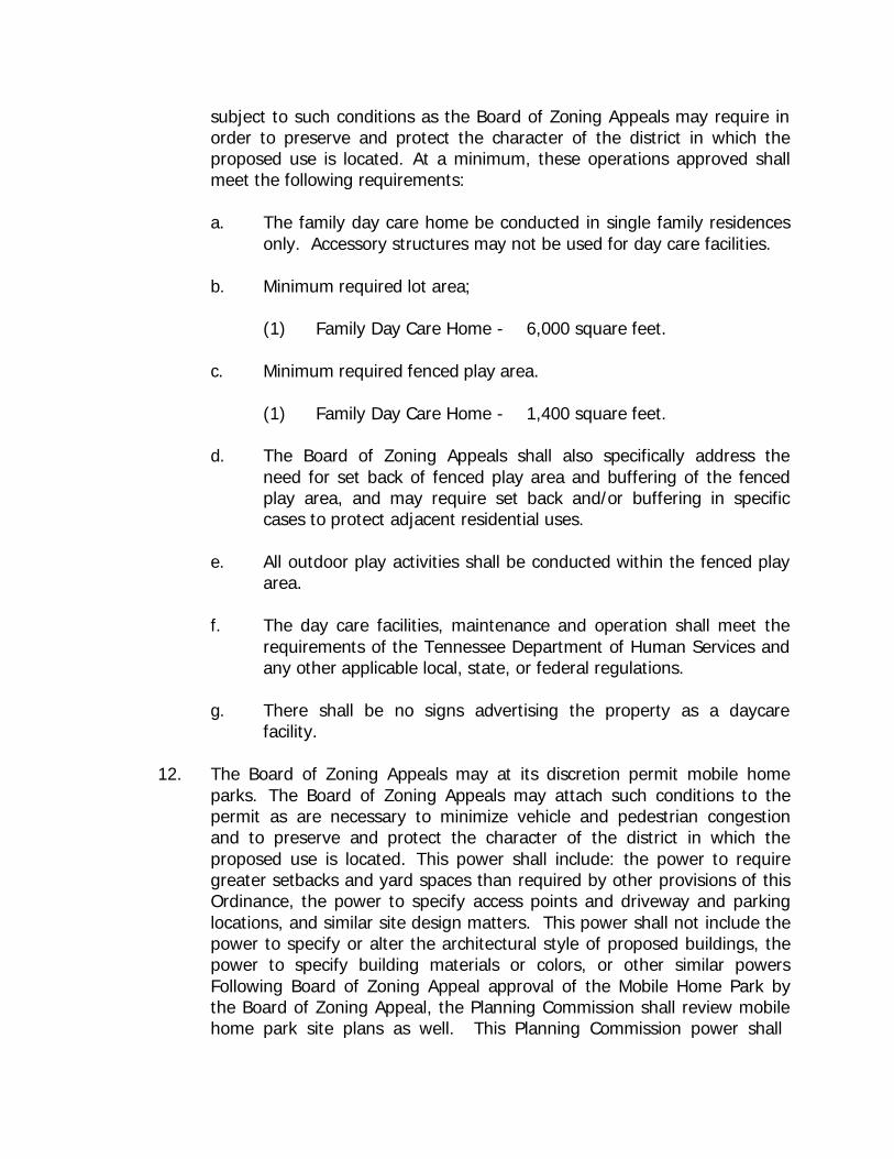
subject to such conditions as the Board of Zoning Appeals may require in order to preserve and protect the character of the district in which the proposed use is located. At a minimum, these operations approved shall meet the following requirements:
a. The family day care home be conducted in single family residences
only. Accessory structures may not be used for day care facilities.
b. Minimum required lot area;
(1) Family Day Care Home - 6,000 square feet.
c. Minimum required fenced play area.
(1) Family Day Care Home - 1,400 square feet.
d. The Board of Zoning Appeals shall also specifically address the need for set back of fenced play area and buffering of the fenced play area, and may require set back and/or buffering in specific cases to protect adjacent residential uses.
e. All outdoor play activities shall be conducted within the fenced play
area.
f. The day care facilities, maintenance and operation shall meet the requirements of the Tennessee Department of Human Services and any other applicable local, state, or federal regulations.
g. There shall be no signs advertising the property as a daycare
facility.
12. The Board of Zoning Appeals may at its discretion permit mobile home parks. The Board of Zoning Appeals may attach such conditions to the permit as are necessary to minimize vehicle and pedestrian congestion and to preserve and protect the character of the district in which the proposed use is located. This power shall include: the power to require greater setbacks and yard spaces than required by other provisions of this Ordinance, the power to specify access points and driveway and parking locations, and similar site design matters. This power shall not include the power to specify or alter the architectural style of proposed buildings, the power to specify building materials or colors, or other similar powers Following Board of Zoning Appeal approval of the Mobile Home Park by the Board of Zoning Appeal, the Planning Commission shall review mobile home park site plans as well. This Planning Commission power shall
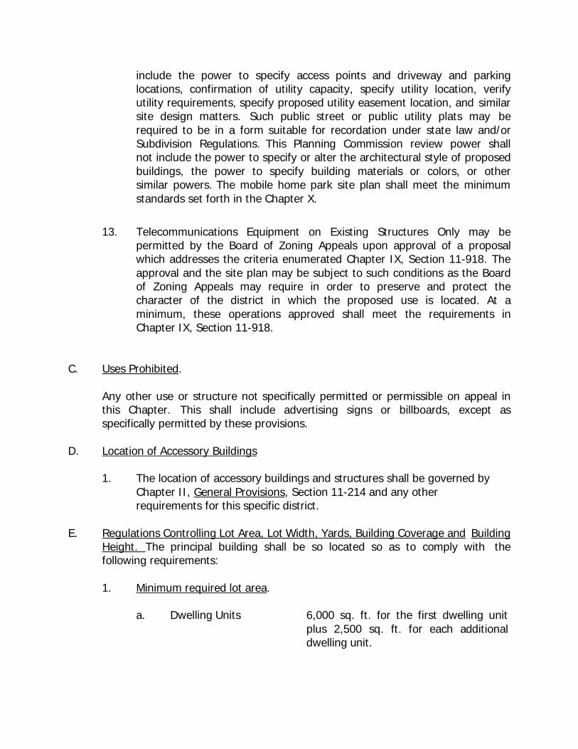
include the power to specify access points and driveway and parking locations, confirmation of utility capacity, specify utility location, verify utility requirements, specify proposed utility easement location, and similar site design matters. Such public street or public utility plats may be required to be in a form suitable for recordation under state law and/or Subdivision Regulations. This Planning Commission review power shall not include the power to specify or alter the architectural style of proposed buildings, the power to specify building materials or colors, or other similar powers. The mobile home park site plan shall meet the minimum standards set forth in the Chapter X.
13. Telecommunications Equipment on Existing Structures Only may be
permitted by the Board of Zoning Appeals upon approval of a proposal which addresses the criteria enumerated Chapter IX, Section 11-918. The approval and the site plan may be subject to such conditions as the Board of Zoning Appeals may require in order to preserve and protect the character of the district in which the proposed use is located. At a minimum, these operations approved shall meet the requirements in Chapter IX, Section 11-918.
C. Uses Prohibited.
Any other use or structure not specifically permitted or permissible on appeal in this Chapter. This shall include advertising signs or billboards, except as specifically permitted by these provisions.
D. Location of Accessory Buildings
1. The location of accessory buildings and structures shall be governed by Chapter II, General Provisions, Section 11-214 and any other requirements for this specific district.
E. Regulations Controlling Lot Area, Lot Width, Yards, Building Coverage and Building
Height. The principal building shall be so located so as to comply with the following requirements:
1. Minimum required lot area.
a. Dwelling Units 6,000 sq. ft. for the first dwelling unit
plus 2,500 sq. ft. for each additional dwelling unit.
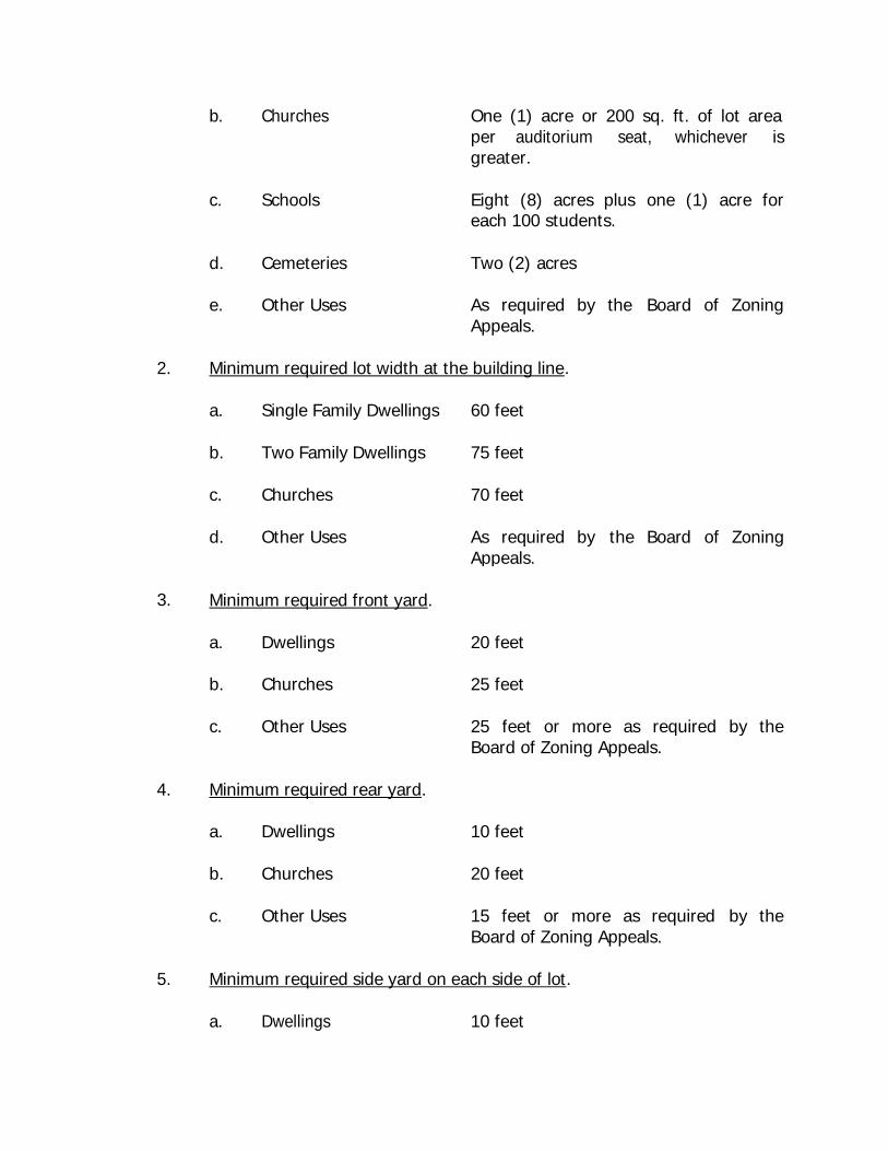
b. Churches One (1) acre or 200 sq. ft. of lot area per auditorium seat, whichever is
c.
Schools
greater.
Eight (8) acres plus
one (1) acre for
each 100 students.
d. Cemeteries Two (2) acres
e. Other Uses As required by the Appeals.
Board of Zoning
2. Minimum required lot width at the building line.
3.
Board of Zoning Appeals.
4. Minimum required rear yard.
a. Dwellings 10 feet
b. Churches 20 feet
c. Other Uses 15 feet or more as required Board of Zoning Appeals.
by the
5. Minimum required side yard on each side of lot.
a. Dwellings 10 feet
a. Single Family Dwellings 60 feet
b. Two Family Dwellings 75 feet
c. Churches 70 feet
d. Other Uses As required by Appeals.
the Board of Zoning
Minimum required front yard.
a. Dwellings 20 feet
b. Churches 25 feet
c. Other Uses 25 feet or more as required by the
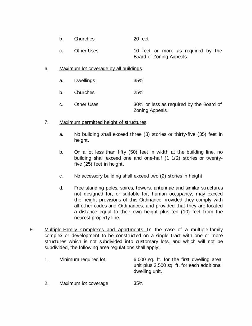
b. Churches 20 feet
c. Other Uses 10 feet or more as required by the Board of Zoning Appeals.
6. Maximum lot coverage by all buildings.
a. Dwellings 35%
b. Churches 25%
c. Other Uses 30% or less as required by the Board of Zoning Appeals.
7. Maximum permitted height of structures.
a. No building shall exceed three (3) stories or thirty-five (35) feet in height.
b. On a lot less than fifty (50) feet in width at the building line, no
building shall exceed one and one-half (1 1/2) stories or twenty- five (25) feet in height.
c. No accessory building shall exceed two (2) stories in height.
d. Free standing poles, spires, towers, antennae and similar structures
not designed for, or suitable for, human occupancy, may exceed the height provisions of this Ordinance provided they comply with all other codes and Ordinances, and provided that they are located a distance equal to their own height plus ten (10) feet from the nearest property line.
F. Multiple-Family Complexes and Apartments. In the case of a multiple-family
complex or development to be constructed on a single tract with one or more structures which is not subdivided into customary lots, and which will not be subdivided, the following area regulations shall apply:
1. Minimum required lot 6,000 sq. ft. for the first dwelling area unit plus 2,500 sq. ft. for each additional 2.
Maximum lot coverage
dwelling unit.
35%
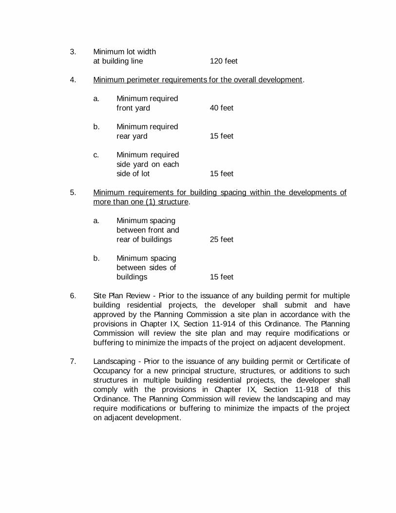
3. Minimum lot width at building line 120 feet
4. Minimum perimeter requirements for the overall development.
a. Minimum required front yard
40 feet
b. Minimum required rear yard
15 feet
c. Minimum required side yard on each side of lot
15 feet
5. Minimum requirements for building spacing within the developments of more than one (1) structure.
a. Minimum spacing between front and rear of buildings
25 feet
b. Minimum spacing between sides of buildings
15 feet
6. Site Plan Review - Prior to the issuance of any building permit for multiple building residential projects, the developer shall submit and have approved by the Planning Commission a site plan in accordance with the provisions in Chapter IX, Section 11-914 of this Ordinance. The Planning Commission will review the site plan and may require modifications or buffering to minimize the impacts of the project on adjacent development.
7. Landscaping - Prior to the issuance of any building permit or Certificate of
Occupancy for a new principal structure, structures, or additions to such structures in multiple building residential projects, the developer shall comply with the provisions in Chapter IX, Section 11-918 of this Ordinance. The Planning Commission will review the landscaping and may require modifications or buffering to minimize the impacts of the project on adjacent development.
11-504. R-4 (High Density Mixed Structure Residential) District - The purpose of the high density district is to specify areas with the appropriate traffic and utility infrastructure to support multi-family development in combination with single family manufactured structures and mobile homes.
Within the R-4 (High Density Mixed Structure Residential) Districts as shown in the Official Zoning Map of Lexington, Tennessee the following regulations shall apply:
A. Uses Permitted
1. Single, two, and multiple-family dwelling.
2. Mobile homes shall be allowed as follows: single unit mobile homes located on individual lots provided that each mobile home lot be provided at the unit owner's expense with either a planted screen or fence which meets the approval of the Planning Commission. The planted screen fence or other Planning Commission approved barrier shall be placed along all side and rear lot lines so as to effectively screen the site from neighboring structures.
Each mobile home shall also have its wheels removed upon set-up, and shall be placed on a permanent standard foundation such as slag blocks, brick, concrete pad or other type foundation deemed acceptable by the Planning Commission. The tongue of each trailer shall be removed or covered to the satisfaction of the Planning Commission. Each mobile home shall be allowed subject to all provisions and regulations existing to govern the location of such facilities.
3. Accessory buildings customarily incidental to any aforementioned permitted
use.
4. Signs in accordance with Chapter IX of this Ordinance B. Uses Permissible on Appeal
1. Churches and other Places of Worship 2 Schools 3. Municipal, County, State or Federal uses 4. Libraries 5. Parks and Recreational facilities 6. Transportation right-of-ways 7. Public utilities facilities 8. Cemeteries 9. Nursing Homes and Elderly-Assisted Care Facilities
a. As a condition of approval of the aforementioned Uses Permissible on Appeal, site plans shall be approved by the Board of Zoning Appeals in accordance with Chapter VII of this Ordinance. The Board of Zoning Appeals may attach such conditions to the permit as are necessary to minimize vehicle and pedestrian congestion and to preserve and protect the character of the district in which the proposed use is located. This power shall include: the power to require greater setbacks and yard spaces than required by other provisions of this Ordinance, the power to specify access points and driveway and parking locations, and similarly site design matters. This power shall not include the power to specify or alter the architectural style of proposed buildings, the power to specify building materials or colors, or other similar powers.
10. Customary incidental home occupations provided that no building permit
or certificate of occupancy for such use shall be issued without the written approval of the Board of Zoning Appeals and subject to such conditions as the Board of Zoning Appeals may require in order to preserve and protect the character of the neighborhood in which the proposed use is located; and provided further that:
a. the proposed use shall be located and conducted in the principal
building only;
b. the principal and employees engaged in the proposed use shall be residents of the dwelling unit in which the proposed use is located;
c. not more than fifteen (15) percent of the total floor area in dwelling
unit shall be devoted to the proposed use;
d. the proposed use shall not constitute primary or incidental storage facilities for a business, industrial, or agricultural activity conducted elsewhere;
e. no activity, materials, goods, or equipment indicative of the
proposed use shall be visible from any public way;
f. the proposed use shall not be advertised by the display of goods or signs on the lot on which the proposed use is located;
g. the proposed use shall not generate noise, odor, fumes, smoke,
vehicular or pedestrian traffic, nor nuisance of any kind which
would tend to depreciate the residential character of the neighborhood in which the proposed use is located;
h. the provisions of this section shall not be used under any
circumstances to permit beauty and barber services; gift, florist, antique shops or other retail shops; or medical and health services specifically due to the burdens of traffic, parking, and utility demands posed by these operations.
11. Family Care Centers, as defined in Chapter 3 under Nursery School, may
be permitted by the Board of Zoning Appeals upon approval of a site plan which is drawn to scale and which addresses the criteria enumerated Chapter IX, Section 11-914. The approval and the site plan may be subject to such conditions as the Board of Zoning Appeals may require in order to preserve and protect the character of the district in which the proposed use is located. At a minimum, these operations approved shall meet the following requirements:
a. The family day care home be conducted in single family residences
only. Accessory structures may not be used for day care facilities.
b. Minimum required lot area;
(1) Family Day Care Home - 6,000 square feet.
c. Minimum required fenced play area.
(1) Family Day Care Home - 1,400 square feet.
d. The Board of Zoning Appeals shall also specifically address the need for setback of fenced play area and buffering of the fenced play area, and may require set back and/or buffering in specific cases to protect adjacent residential uses.
e. All outdoor play activities shall be conducted within the fenced play
area.
f. The day care facilities, maintenance and operation shall meet the requirements of the Tennessee Department of Human Services and any other applicable local, state, or federal regulations.
g. There shall be no signs advertising the property as a daycare
facility.
12. The Board of Zoning Appeals may at its discretion permit mobile home parks. The Board of Zoning Appeals may attach such conditions to the permit as are necessary to minimize vehicle and pedestrian congestion and to preserve and protect the character of the district in which the proposed use is located. This power shall include: the power to require greater setbacks and yard spaces than required by other provisions of this Ordinance, the power to specify access points and driveway and parking locations, and similar site design matters. This power shall not include the power to specify or alter the architectural style of proposed buildings, the power to specify building materials or colors, or other similar powers Following Board of Zoning Appeal approval of the Mobile Home Park by the Board of Zoning Appeal, the Planning Commission shall review mobile home park site plans as well. This Planning Commission power shall include the power to specify access points and driveway and parking locations, confirmation of utility capacity, specify utility location, verify utility requirements, specify proposed utility easement location, and similar site design matters. Such public street or public utility plats may be required to be in a form suitable for recordation under state law and/or Subdivision Regulations. This Planning Commission review power shall not include the power to specify or alter the architectural style of proposed buildings, the power to specify building materials or colors, or other similar powers. The mobile home park site plan shall meet the minimum standards set forth in the Chapter X.
13. Telecommunications Equipment on Existing Structures Only may be permitted by the Board of Zoning Appeals upon approval of a proposal which addresses the criteria enumerated Chapter IX, Section 11-918. The approval and the site plan may be subject to such conditions as the Board of Zoning Appeals may require in order to preserve and protect the character of the district in which the proposed use is located. At a minimum, these operations approved shall meet the requirements in Chapter IX, Section 11-918.
14. Funeral homes – provided the following:
a. Off street parking requirements shall meet the minimum requirements found in Chapter IX, Section 11-902, Letter G, Number (8) of the Zoning Ordinance of Lexington, Tennessee.
b. All vehicles and equipment shall be stored in appropriate
buildings.
c. In the event a building is to be constructed for such use, the Board of Zoning Appeals may require that the new structure be architecturally designed to conform with the residential character of the neighborhood.
d. No crematory or embalming methods taking place on site.
C. Uses Prohibited.
Any other use or structure not specifically permitted or permissible on appeal in this Chapter. This shall include advertising signs or billboards, except as specifically permitted by these provisions.
D. Location of Accessory Buildings
1. The location of accessory buildings and structures shall be governed by Chapter II, General Provisions, Section 11-214 and any other requirements for this specific district.
E. Regulations Controlling Lot Area, Lot Width, Yards, Building Coverage and
Building Height. The principal building shall be so located so as to comply with the following requirements:
1. Minimum required lot area.
a. Dwelling Units 6,000 sq. ft. for the first dwelling unit plus 2,500 sq. ft. for each additional dwelling unit.
b. Churches One (1) acre or 200 sq. ft. of lot area per auditorium seat, whichever is greater.
c. Schools Eight (8) acres plus each 100 students.
one (1) acre for
d. Cemeteries Two (2) acres
e. Other Uses As required by the Appeals.
Board of Zoning
2. Minimum required lot width at the building line.
a. Single Family Dwellings 60 feet
b. Two Family Dwellings 75 feet
c. Churches 70 feet
d. Other Uses As required by Appeals.
the Board of Zoning
3. Minimum required front yard.
a. Dwellings 20 feet
b. Churches 25 feet
c. Other Uses 25 feet or more as required by the Board of Zoning Appeals.
4. Minimum required rear yard.
a. Dwellings 10 feet
b. Churches 20 feet
c. Other Uses 15 feet or more as required Board of Zoning Appeals.
by the
5. Minimum required side yard on each side of lot.
a. Dwellings 10 feet
b. Churches 20 feet
c. Other Uses 10 feet or more as required Board of Zoning Appeals.
by the
6. Maximum lot coverage by all buildings.
a. Dwellings 35%
b. Churches 25%
c. Other Uses 30% or less as required by the Board of Zoning Appeals.
7. Maximum permitted height of structures.
a. No building shall exceed three (3) stories or thirty-five (35) feet in height.
b. On a lot less than fifty (50) feet in width at the building line, no
building shall exceed one and one-half (1 1/2) stories or twenty- five (25) feet in height.
c. No accessory building shall exceed two (2) stories in height.
d. Free standing poles, spires, towers, antennae and similar structures
not designed for, or suitable for, human occupancy, may exceed the height provisions of this Ordinance provided they comply with all other codes and Ordinances, and provided that they are located a distance equal to their own height plus ten (10) feet from the nearest property line.
F. Multiple-Family Complexes and Apartments. In the case of a multiple-family
complex or development to be constructed on a single tract with one or more structures which is not subdivided into customary lots, and which will not be subdivided, the following area regulations shall apply:
1. Minimum required lot 6,000 sq. ft. for the first dwelling area unit plus 2,500 sq. ft. for each additional dwelling unit.
2. Maximum lot coverage 35%
3. Minimum lot width at building line
120 feet
4. Minimum perimeter requirements for the overall development.
a. Minimum required front yard
40 feet
b. Minimum required rear yard
15 feet
c. Minimum required side yard on each side of lot
15 feet
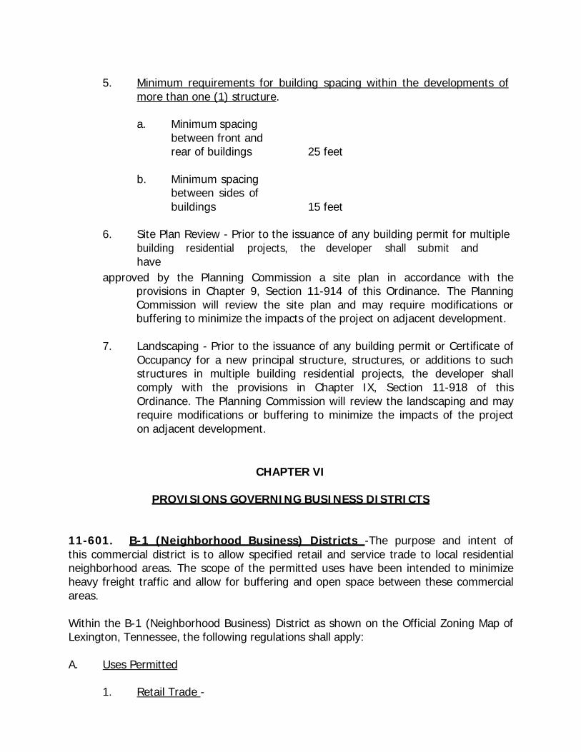
5. Minimum requirements for building spacing within the developments of more than one (1) structure.
a. Minimum spacing between front and rear of buildings
25 feet
b. Minimum spacing between sides of buildings
15 feet
6. Site Plan Review - Prior to the issuance of any building permit for multiple building residential projects, the developer shall submit andhave
approved by the Planning Commission a site plan in accordance with the provisions in Chapter 9, Section 11-914 of this Ordinance. The Planning Commission will review the site plan and may require modifications or buffering to minimize the impacts of the project on adjacent development.
7. Landscaping - Prior to the issuance of any building permit or Certificate of
Occupancy for a new principal structure, structures, or additions to such structures in multiple building residential projects, the developer shall comply with the provisions in Chapter IX, Section 11-918 of this Ordinance. The Planning Commission will review the landscaping and may require modifications or buffering to minimize the impacts of the project on adjacent development.
CHAPTER VI
PROVISIONS GOVERNING BUSINESS DISTRICTS 11-601. B-1 (Neighborhood Business) Districts -The purpose and intent of this commercial district is to allow specified retail and service trade to local residential neighborhood areas. The scope of the permitted uses have been intended to minimize heavy freight traffic and allow for buffering and open space between these commercial areas.
Within the B-1 (Neighborhood Business) District as shown on the Official Zoning Map of Lexington, Tennessee, the following regulations shall apply:
A. Uses Permitted
1. Retail Trade -
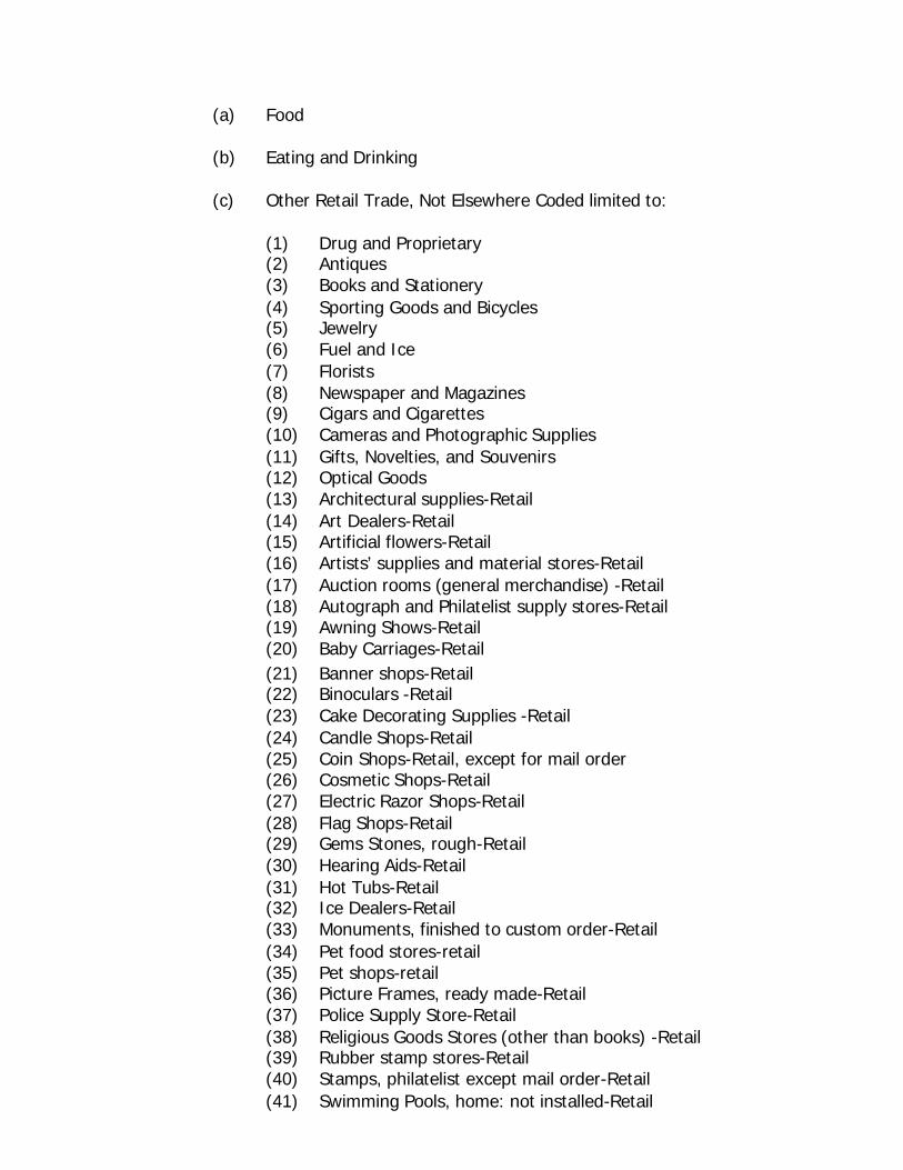
(a) Food
(b) Eating and Drinking
(c) Other Retail Trade, Not Elsewhere Coded limited to:
(1) Drug and Proprietary (2) Antiques (3) Books and Stationery (4) Sporting Goods and Bicycles (5) Jewelry (6) Fuel and Ice (7) Florists (8) Newspaper and Magazines (9) Cigars and Cigarettes (10) Cameras and Photographic Supplies (11) Gifts, Novelties, and Souvenirs (12) Optical Goods (13) Architectural supplies-Retail (14) Art Dealers-Retail (15) Artificial flowers-Retail (16) Artists’ supplies and material stores-Retail (17) Auction rooms (general merchandise) -Retail (18) Autograph and Philatelist supply stores-Retail (19) Awning Shows-Retail (20) Baby Carriages-Retail (21) Banner shops-Retail (22) Binoculars -Retail (23) Cake Decorating Supplies -Retail (24) Candle Shops-Retail (25) Coin Shops-Retail, except for mail order (26) Cosmetic Shops-Retail (27) Electric Razor Shops-Retail (28) Flag Shops-Retail (29) Gems Stones, rough-Retail (30) Hearing Aids-Retail (31) Hot Tubs-Retail (32) Ice Dealers-Retail (33) Monuments, finished to custom order-Retail (34) Pet food stores-retail (35) Pet shops-retail (36) Picture Frames, ready made-Retail (37) Police Supply Store-Retail (38) Religious Goods Stores (other than books) -Retail (39) Rubber stamp stores-Retail (40) Stamps, philatelist except mail order-Retail (41) Swimming Pools, home: not installed-Retail
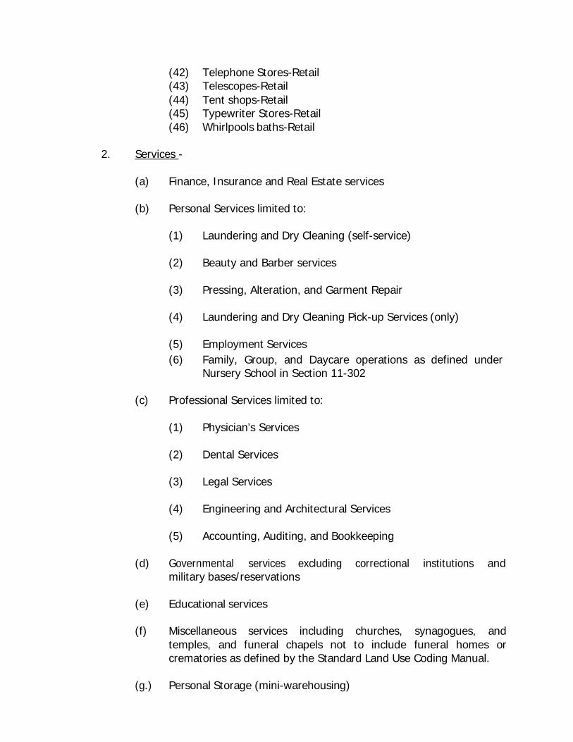
(42) Telephone Stores-Retail (43) Telescopes-Retail (44) Tent shops-Retail (45) Typewriter Stores-Retail (46) Whirlpools baths-Retail
2. Services -
(a) Finance, Insurance and Real Estate services
(b) Personal Services limited to:
(1) Laundering and Dry Cleaning (self-service)
(2) Beauty and Barber services
(3) Pressing, Alteration, and Garment Repair
(4) Laundering and Dry Cleaning Pick-up Services (only)
(5) Employment Services (6) Family, Group, and Daycare operations as defined under
Nursery School in Section 11-302
(c) Professional Services limited to:
(1) Physician’s Services
(2) Dental Services
(3) Legal Services
(4) Engineering and Architectural Services
(5) Accounting, Auditing, and Bookkeeping
(d) Governmental services excluding correctional institutions and military bases/reservations
(e) Educational services
(f) Miscellaneous services including churches, synagogues, and
temples, and funeral chapels not to include funeral homes or crematories as defined by the Standard Land Use Coding Manual.
(g.) Personal Storage (mini-warehousing)
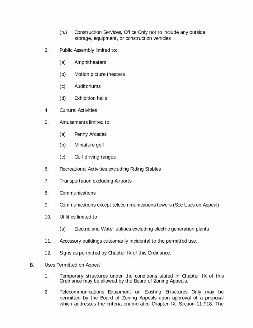
(h.) Construction Services, Office Only not to include any outside storage, equipment, or construction vehicles
3. Public Assembly limited to:
(a) Amphitheaters
(b) Motion picture theaters
(c) Auditoriums
(d) Exhibition halls
4. Cultural Activities
5. Amusements limited to:
(a) Penny Arcades
(b) Miniature golf
(c) Golf driving ranges
6. Recreational Activities excluding Riding Stables
7. Transportation excluding Airports
8. Communications
9. Communications except telecommunications towers (See Uses on Appeal)
10. Utilities limited to
(a) Electric and Water utilities excluding electric generation plants
11. Accessory buildings customarily incidental to the permitted use.
12. Signs as permitted by Chapter IX of this Ordinance. B. Uses Permitted on Appeal
1. Temporary structures under the conditions stated in Chapter IX of this Ordinance may be allowed by the Board of Zoning Appeals.
2. Telecommunications Equipment on Existing Structures Only may be
permitted by the Board of Zoning Appeals upon approval of a proposal which addresses the criteria enumerated Chapter IX, Section 11-918. The
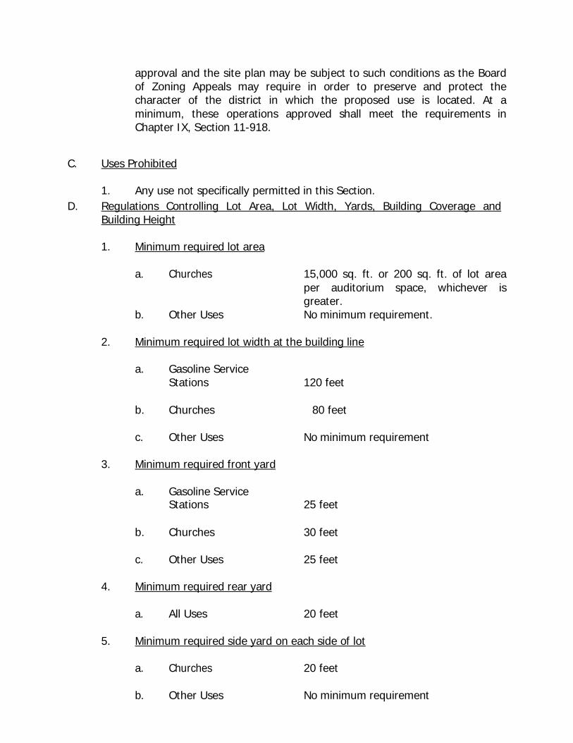
approval and the site plan may be subject to such conditions as the Board of Zoning Appeals may require in order to preserve and protect the character of the district in which the proposed use is located. At a minimum, these operations approved shall meet the requirements in Chapter IX, Section 11-918.
C. Uses Prohibited
1. Any use not specifically permitted in this Section. D. Regulations Controlling Lot Area, Lot Width, Yards, Building Coverage and
Building Height
1. Minimum required lot area
a. Churches 15,000 sq. ft. or 200 sq. ft. of lot area per auditorium space, whichever is greater.
b. Other Uses No minimum requirement.
2. Minimum required lot width at the building line
a. Gasoline Service
b.
Stations
Churches
120 feet
80 feet
c. Other Uses No minimum requirement
3. Minimum required front yard
a. Gasoline Service
b.
Stations
Churches
25 feet
30 feet
c. Other Uses 25 feet
4. Minimum required rear yard
a. All Uses 20 feet
5. Minimum required side yard on each side of lot
a. Churches 20 feet
b. Other Uses No minimum requirement
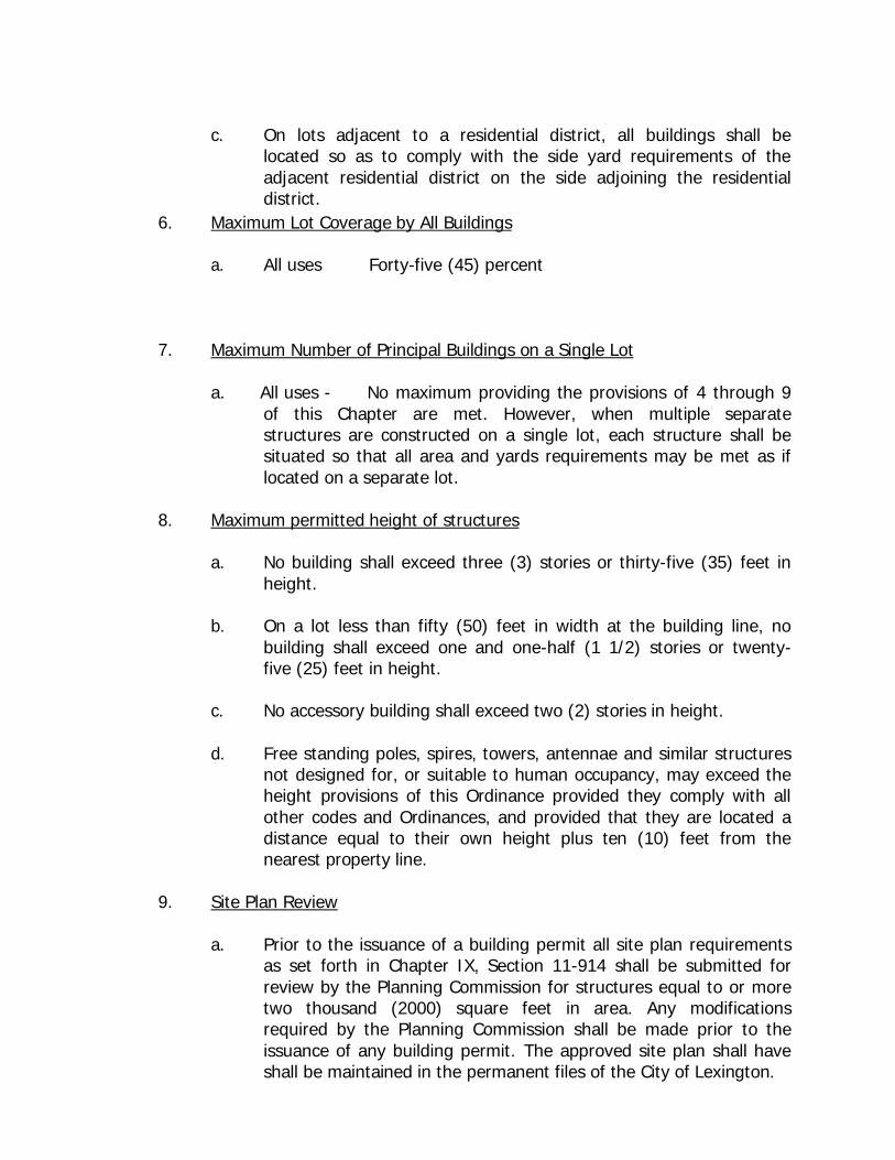
c. On lots adjacent to a residential district, all buildings shall be
located so as to comply with the side yard requirements of the adjacent residential district on the side adjoining the residential district.
6. Maximum Lot Coverage by All Buildings
a. All uses Forty-five (45) percent
7. Maximum Number of Principal Buildings on a Single Lot
a. All uses - No maximum providing the provisions of 4 through 9 of this Chapter are met. However, when multiple separate structures are constructed on a single lot, each structure shall be situated so that all area and yards requirements may be met as if located on a separate lot.
8. Maximum permitted height of structures
a. No building shall exceed three (3) stories or thirty-five (35) feet in height.
b. On a lot less than fifty (50) feet in width at the building line, no
building shall exceed one and one-half (1 1/2) stories or twenty- five (25) feet in height.
c. No accessory building shall exceed two (2) stories in height.
d. Free standing poles, spires, towers, antennae and similar structures
not designed for, or suitable to human occupancy, may exceed the height provisions of this Ordinance provided they comply with all other codes and Ordinances, and provided that they are located a distance equal to their own height plus ten (10) feet from the nearest property line.
9. Site Plan Review
a. Prior to the issuance of a building permit all site plan requirements as set forth in Chapter IX, Section 11-914 shall be submitted for review by the Planning Commission for structures equal to or more two thousand (2000) square feet in area. Any modifications required by the Planning Commission shall be made prior to the issuance of any building permit. The approved site plan shall have shall be maintained in the permanent files of the City of Lexington.
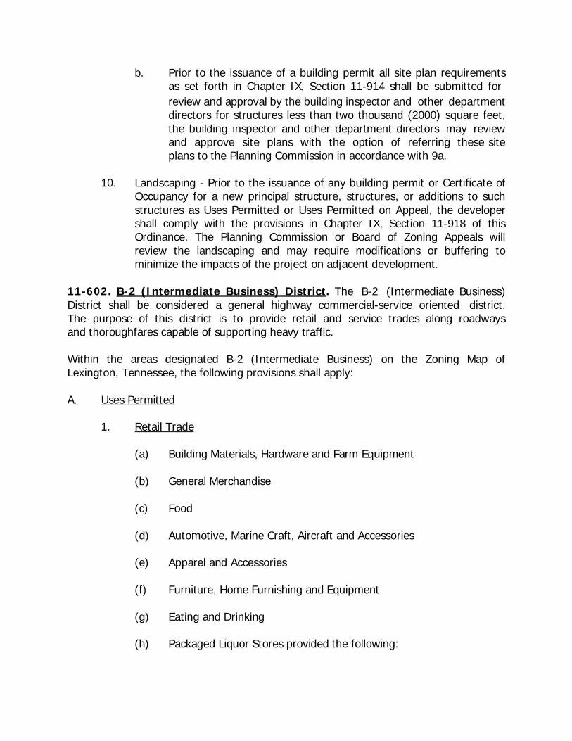
b. Prior to the issuance of a building permit all site plan requirements as set forth in Chapter IX, Section 11-914 shall be submitted for review and approval by the building inspector and other department directors for structures less than two thousand (2000) square feet, the building inspector and other department directors may review and approve site plans with the option of referring these site plans to the Planning Commission in accordance with 9a.
10. Landscaping - Prior to the issuance of any building permit or Certificate of
Occupancy for a new principal structure, structures, or additions to such structures as Uses Permitted or Uses Permitted on Appeal, the developer shall comply with the provisions in Chapter IX, Section 11-918 of this Ordinance. The Planning Commission or Board of Zoning Appeals will review the landscaping and may require modifications or buffering to minimize the impacts of the project on adjacent development.
11-602. B-2 (Intermediate Business) District. The B-2 (Intermediate Business) District shall be considered a general highway commercial-service oriented district. The purpose of this district is to provide retail and service trades along roadways and thoroughfares capable of supporting heavy traffic.
Within the areas designated B-2 (Intermediate Business) on the Zoning Map of Lexington, Tennessee, the following provisions shall apply:
A. Uses Permitted
1. Retail Trade
(a) Building Materials, Hardware and Farm Equipment
(b) General Merchandise
(c) Food
(d) Automotive, Marine Craft, Aircraft and Accessories
(e) Apparel and Accessories
(f) Furniture, Home Furnishing and Equipment
(g) Eating and Drinking
(h) Packaged Liquor Stores provided the following:

(i) No packaged liquor store shall be permitted to locate within 500 feet from a pre-existing public or private school, childcare facility or established place of worship or hospital;
(ii) No packaged liquor store shall be permitted to locate within
500 feet from a public park, public space, or other similar public open space, which caters to family groups and children;
(iii) Shall be located on a major arterial status road as classified
on the adopted Lexington Municipal-Regional Major Road Plan Map;
(iv) For the purpose of this section, measurements shall be
made in a straight line from property line to property line.
(i) Other Retail Trade, Not Elsewhere Coded
(1) Drug and Proprietary (2) Antiques (3) Books and Stationery (4) Sporting Goods and Bicycles (5) Farm and Garden Supplies (6) Jewelry (7) Fuel and Ice (8) Florists (9) Newspaper and Magazines (10) Cigars and Cigarettes (11) Cameras and Photographic Supplies (12) Gifts, Novelties, and Souvenirs (13) Optical Goods (14) Architectural supplies-Retail (15) Art Dealers-Retail (16) Artificial flowers-Retail (17) Artists’ supplies and material stores-Retail (18) Auction rooms (general merchandise) -Retail (19) Autograph and Philatelist supply stores-Retail (20) Awning Shows-Retail (21) Baby Carriages-Retail (22) Banner shops-Retail (23) Binoculars -Retail (24) Cake Decorating Supplies -Retail
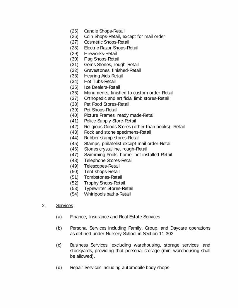
(25) Candle Shops-Retail (26) Coin Shops-Retail, except for mail order (27) Cosmetic Shops-Retail (28) Electric Razor Shops-Retail (29) Fireworks-Retail (30) Flag Shops-Retail (31) Gems Stones, rough-Retail (32) Gravestones, finished-Retail (33) Hearing Aids-Retail (34) Hot Tubs-Retail (35) Ice Dealers-Retail (36) Monuments, finished to custom order-Retail (37) Orthopedic and artificial limb stores-Retail (38) Pet Food Stores-Retail (39) Pet Shops-Retail (40) Picture Frames, ready made-Retail (41) Police Supply Store-Retail (42) Religious Goods Stores (other than books) -Retail (43) Rock and stone specimens-Retail (44) Rubber stamp stores-Retail (45) Stamps, philatelist except mail order-Retail (46) Stones crystalline, rough-Retail (47) Swimming Pools, home: not installed-Retail (48) Telephone Stores-Retail (49) Telescopes-Retail (50) Tent shops-Retail (51) Tombstones-Retail (52) Trophy Shops-Retail (53) Typewriter Stores-Retail (54) Whirlpools baths-Retail
2. Services
(a) Finance, Insurance and Real Estate Services
(b) Personal Services including Family, Group, and Daycare operations as defined under Nursery School in Section 11-302
(c) Business Services, excluding warehousing, storage services, and
stockyards, providing that personal storage (mini-warehousing shall be allowed).
(d) Repair Services including automobile body shops
(e) Professional Services including convalescent and rest home services
(f) Contract Construction Services
(g) Governmental Services excluding military bases/reservations
(h) Educational Services
(i) Miscellaneous Services including churches, synagogues, and temples
(j) Small Animal Clinics excluding livestock, swine, and equine care or
any clinic involving outside treatment, recovery, or storage.
3. Wholesale Trade
(a) Drugs, Chemicals, and Allied products
(b) Dry Goods and Apparel
(c) Farm Products (raw materials) limited to Cotton, Grains, and Field Beans
(d) Electrical Goods
(e) Hardware, Plumbing, and Heating Equipment
(f) Machinery, Equipment, and Supplies
(g) Other Wholesale Trade, Not Elsewhere Coded, limited to:
(1) Paper and Paper Products
(2) Furniture and Home Furnishings
(3) Lumber and Construction Materials
4. Public Assembly
5. Cultural Activities
6. Recreational Activities
7. Transient Lodging
8. Transportation excluding Airports
9. Communications except telecommunications towers (See Uses on Appeal)
10. Utilities limited to
(a) Electric and Water utilities excluding electric generation plants
11. Accessory buildings customarily incidental to the permitted use.
12. Signs as permitted in Chapter IX of this Ordinance
13. Manufacturing incidental to retail businesses or services where products are sold on the premises by the producer and where no more than ten (10) operatives are employed in such manufacturing operation.
B. Uses Permitted on Appeal
1. Temporary structures, under the conditions of Chapter IX of this Ordinance may be allowed by the Board of Zoning Appeals.
2. Telecommunications Equipment on Existing Structures Only may be
permitted by the Board of Zoning Appeals upon approval of a proposal which addresses the criteria enumerated Chapter IX, Section 11-918. The approval and the site plan may be subject to such conditions as the Board of Zoning Appeals may require in order to preserve and protect the character of the district in which the proposed use is located. At a minimum, these operations approved shall meet the requirements in Chapter IX, Section 11-918.
C. Uses Prohibited
1. Any use not specifically permitted by the Ordinance D. Regulations Controlling Lot Area, Lot Width, Yards, Building Coverage and
Building Height
1. Minimum required lot area
a. Churches 15,000 sq. ft. or 200 sq. ft. of lot area per auditorium space, whichever is greater.
b. Other Uses No minimum requirement.
2. Minimum Lot width Measured at the Building Line
a. Churches 100 feet
b. Other uses No minimum requirement
3. Minimum Depth of Front Yards
a. All uses Twenty-five (25) ft.
4. Minimum Depth of Rear Yard
a. All uses Twenty (20) feet, provided that when the commercial lot adjoins a residential district along the rear lot line that the minimum depth of the rear yard shall be twenty-five (25) feet.
5. Minimum Width of Side Yards
a. Churches Twenty-five (25)
b. Other uses A periphery side yard shall be required for all developments within the B-2 (Intermediate Business) District of 10 feet, provided that when the B-2 (Intermediate Business) District lot adjoins a residential district along the side yard, the minimum side yard shall comply with the side yard requirements of the adjacent residential district on the side adjacent to the residential district.
Internal to a zero lot line development no side yard is required for individual uses constructed as part of an attached structure development, provided all applicable zoning Ordinance requirements are complied with , including access and parking provisions, and all City and State construction codes are met.
6. Maximum Lot Coverage by All Buildings
a. All uses Forty-five (45) percent
7. Maximum Number of Principal Buildings on a Single Lot
a. All uses No maximum providing the provisions of this Ordinance are met. However, when multiple separate structures are constructed on a single lot, each structure shall be situated so that all area and yards requirements may be met as if located on a separate lot.
8. Maximum Height
a. All uses No structures shall exceed three (3) stories or thirty- five (35) feet in height. This limitation shall not apply
to belfries, chimneys, church spires, flagpoles, radio and television antennas and water tanks or stand pipes provided they comply with the provisions of all pertinent codes and Ordinances and provided that they are located a distance equal to their height plus ten (10) feet from the nearest property line.
9. Accessory buildings
1. The location of accessory buildings and structures shall be governed by Chapter II, General Provisions, Section 11-214 and any other requirements for this specific district.
10. Site Plan Review
a. Prior to the issuance of a building permit all site plan requirements as set forth in Chapter IX, Section 11-914 shall be submitted for review by the Planning Commission for structures equal to or more two thousand (2000) square feet in area. Any modifications required by the Planning Commission shall be made prior to the issuance of any building permit. The approved site plan shall have shall be maintained in the permanent files of the City of Lexington.
b. Prior to the issuance of a building permit all site plan requirements
as set forth in Chapter IX, Section 11-914 shall be submitted for review and approval by the building inspector and other department directors for structures less than two thousand (2000) square feet, the building inspector and other department directors may review and approve site plans with the option of referring these site plans to the Planning Commission in accordance with 9a.
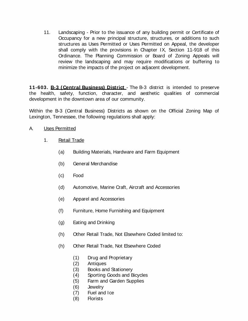
11. Landscaping - Prior to the issuance of any building permit or Certificate of Occupancy for a new principal structure, structures, or additions to such structures as Uses Permitted or Uses Permitted on Appeal, the developer shall comply with the provisions in Chapter IX, Section 11-918 of this Ordinance. The Planning Commission or Board of Zoning Appeals will review the landscaping and may require modifications or buffering to minimize the impacts of the project on adjacent development.
11-603. B-3 (Central Business) District - The B-3 district is intended to preserve the health, safety, function, character, and aesthetic qualities of commercial development in the downtown area of our community.
Within the B-3 (Central Business) Districts as shown on the Official Zoning Map of Lexington, Tennessee, the following regulations shall apply:
A. Uses Permitted
1. Retail Trade
(a) Building Materials, Hardware and Farm Equipment
(b) General Merchandise
(c) Food
(d) Automotive, Marine Craft, Aircraft and Accessories
(e) Apparel and Accessories
(f) Furniture, Home Furnishing and Equipment
(g) Eating and Drinking
(h) Other Retail Trade, Not Elsewhere Coded limited to:
(h) Other Retail Trade, Not Elsewhere Coded
(1) Drug and Proprietary (2) Antiques (3) Books and Stationery (4) Sporting Goods and Bicycles (5) Farm and Garden Supplies (6) Jewelry (7) Fuel and Ice (8) Florists
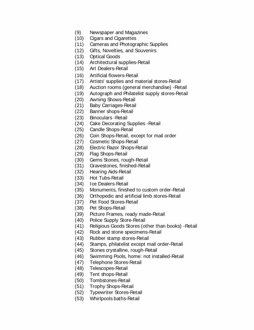
(9) Newspaper and Magazines (10) Cigars and Cigarettes (11) Cameras and Photographic Supplies (12) Gifts, Novelties, and Souvenirs (13) Optical Goods (14) Architectural supplies-Retail (15) Art Dealers-Retail (16) Artificial flowers-Retail (17) Artists’ supplies and material stores-Retail (18) Auction rooms (general merchandise) -Retail (19) Autograph and Philatelist supply stores-Retail (20) Awning Shows-Retail (21) Baby Carriages-Retail (22) Banner shops-Retail (23) Binoculars -Retail (24) Cake Decorating Supplies -Retail (25) Candle Shops-Retail (26) Coin Shops-Retail, except for mail order (27) Cosmetic Shops-Retail (28) Electric Razor Shops-Retail (29) Flag Shops-Retail (30) Gems Stones, rough-Retail (31) Gravestones, finished-Retail (32) Hearing Aids-Retail (33) Hot Tubs-Retail (34) Ice Dealers-Retail (35) Monuments, finished to custom order-Retail (36) Orthopedic and artificial limb stores-Retail (37) Pet Food Stores-Retail (38) Pet Shops-Retail (39) Picture Frames, ready made-Retail (40) Police Supply Store-Retail (41) Religious Goods Stores (other than books) -Retail (42) Rock and stone specimens-Retail (43) Rubber stamp stores-Retail (44) Stamps, philatelist except mail order-Retail (45) Stones crystalline, rough-Retail (46) Swimming Pools, home: not installed-Retail (47) Telephone Stores-Retail (48) Telescopes-Retail (49) Tent shops-Retail (50) Tombstones-Retail (51) Trophy Shops-Retail (52) Typewriter Stores-Retail (53) Whirlpools baths-Retail
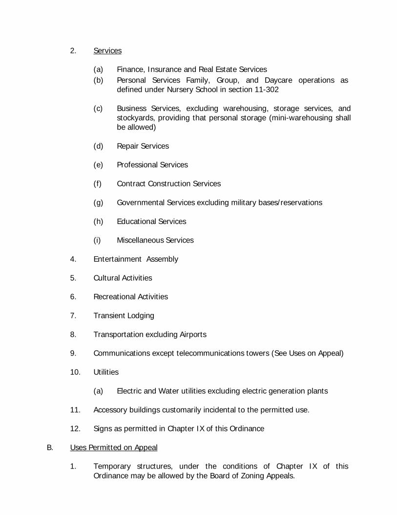
2. Services
(a) Finance, Insurance and Real Estate Services (b) Personal Services Family, Group, and Daycare operations as
defined under Nursery School in section 11-302
(c) Business Services, excluding warehousing, storage services, and stockyards, providing that personal storage (mini-warehousing shall be allowed)
(d) Repair Services
(e) Professional Services
(f) Contract Construction Services
(g) Governmental Services excluding military bases/reservations
(h) Educational Services
(i) Miscellaneous Services
4. Entertainment Assembly
5. Cultural Activities
6. Recreational Activities
7. Transient Lodging
8. Transportation excluding Airports
9. Communications except telecommunications towers (See Uses on Appeal)
10. Utilities
(a) Electric and Water utilities excluding electric generation plants
11. Accessory buildings customarily incidental to the permitted use.
12. Signs as permitted in Chapter IX of this Ordinance
B. Uses Permitted on Appeal
1. Temporary structures, under the conditions of Chapter IX of this Ordinance may be allowed by the Board of Zoning Appeals.
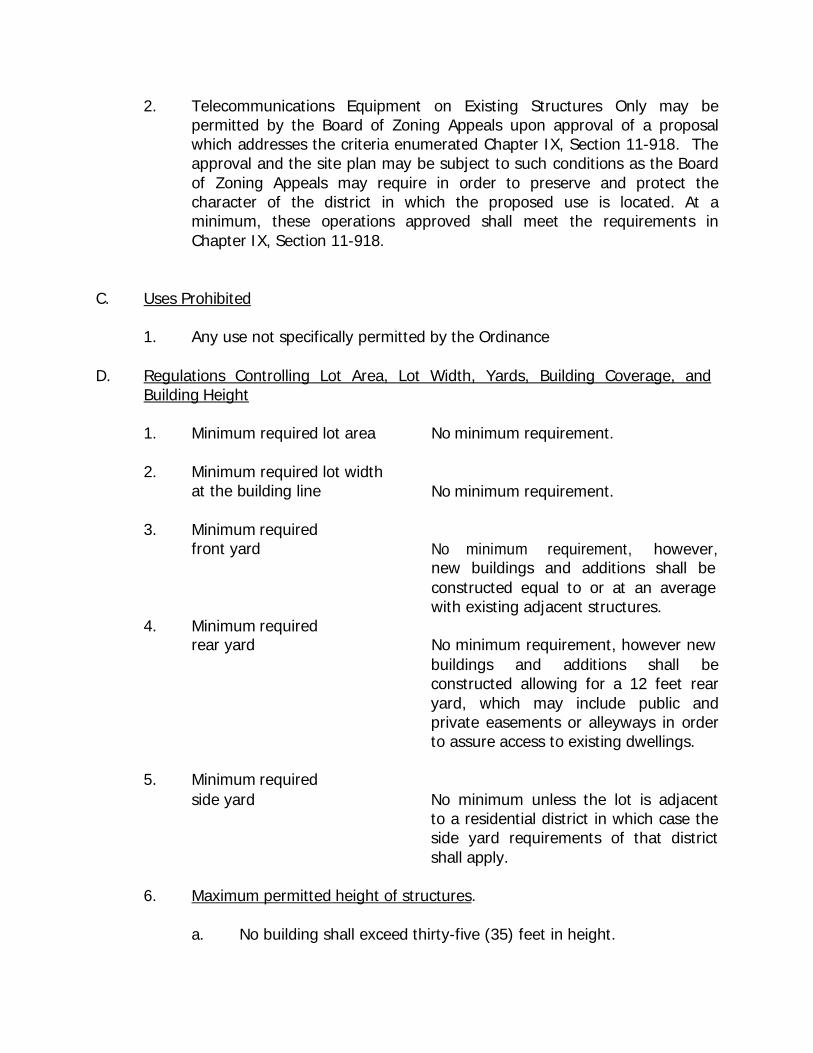
2. Telecommunications Equipment on Existing Structures Only may be permitted by the Board of Zoning Appeals upon approval of a proposal which addresses the criteria enumerated Chapter IX, Section 11-918. The approval and the site plan may be subject to such conditions as the Board of Zoning Appeals may require in order to preserve and protect the character of the district in which the proposed use is located. At a minimum, these operations approved shall meet the requirements in Chapter IX, Section 11-918.
C. Uses Prohibited
1. Any use not specifically permitted by the Ordinance D. Regulations Controlling Lot Area, Lot Width, Yards, Building Coverage, and
Building Height
1. Minimum required lot area No minimum requirement.
2. Minimum required lot width at the building line
No minimum requirement.
3. Minimum required front yard
No minimum requirement, however,
4.
Minimum required
new buildings and additions shall be constructed equal to or at an average with existing adjacent structures.
rear yard No minimum requirement, however new buildings and additions shall be constructed allowing for a 12 feet rear yard, which may include public and private easements or alleyways in order to assure access to existing dwellings.
5. Minimum required
side yard No minimum unless the lot is adjacent to a residential district in which case the side yard requirements of that district shall apply.
6. Maximum permitted height of structures.
a. No building shall exceed thirty-five (35) feet in height.
b. No accessory building shall exceed twenty (20) feet in height.
7. Site Plan Review
a. Prior to the issuance of a building permit all site plan requirements as set forth in Chapter IX, Section 11-914 shall be submitted for review by the Planning Commission for structures equal to or more two thousand (2000) square feet in area. Any modifications required by the Planning Commission shall be made prior to the issuance of any building permit. The approved site plan shall have shall be maintained in the permanent files of the City of Lexington.
b. Prior to the issuance of a building permit all site plan requirements
as set forth in Chapter IX, Section 11-914 shall be submitted for review and approval by the building inspector and other department directors for structures less than two thousand (2000) square feet, the building inspector and other department directors may review and approve site plans with the option of referring these site plans to the Planning Commission in accordance with 9a.
11-604. B-P (Planned Business) Districts - The purpose and intent of the B-P is to ensure that the unique qualities of shopping center and other complex developments with regard to parking, loading, and traffic circulation are evaluated in terms of the other tenants and operations within such developments.
Within the B-P (Planned Business) Districts as shown on the Official Zoning Map of Lexington, Tennessee, the following regulations shall apply:
B. Uses Permitted
1. Retail Trade
(a) Building Materials, Hardware and Farm Equipment
(b) General Merchandise
(c) Food
(d) Automotive, Marine Craft, Aircraft and Accessories
(e) Apparel and Accessories
(f) Furniture, Home Furnishing and Equipment
(g) Eating and Drinking
(h) Other Retail Trade, Not Elsewhere Coded limited
(1) Drug and Proprietary (2) Antiques (3) Books and Stationery (4) Sporting Goods and Bicycles (5) Farm and Garden Supplies (6) Jewelry (7) Fuel and Ice (8) Florists (9) Newspaper and Magazines (10) Cigars and Cigarettes (11) Cameras and Photographic Supplies (12) Gifts, Novelties, and Souvenirs (13) Optical Goods (14) Architectural supplies-Retail (15) Art Dealers-Retail (16) Artificial flowers-Retail (17) Artists’ supplies and material stores-Retail (18) Auction rooms (general merchandise) -Retail (19) Autograph and Philatelist supply stores-Retail (20) Awning Shows-Retail (21) Baby Carriages-Retail (22) Banner shops-Retail (23) Binoculars -Retail (24) Cake Decorating Supplies -Retail (25) Candle Shops-Retail (26) Coin Shops-Retail, except for mail order (27) Cosmetic Shops-Retail (28) Electric Razor Shops-Retail (29) Fireworks-Retail (30) Flag Shops-Retail (31) Gems Stones, rough-Retail (32) Gravestones, finished-Retail (33) Hearing Aids-Retail (34) Hot Tubs-Retail (35) Ice Dealers-Retail (36) Monuments, finished to custom order-Retail (37) Orthopedic and artificial limb stores-Retail (38) Pet Food Stores-Retail
(39) Pet Shops-Retail (40) Picture Frames, ready made-Retail (41) Police Supply Store-Retail (42) Religious Goods Stores (other than books) -Retail (43) Rock and stone specimens-Retail (44) Rubber stamp stores-Retail (45) Stamps, philatelist except mail order-Retail (46) Stones crystalline, rough-Retail (47) Swimming Pools, home: not installed-Retail (48) Telephone Stores-Retail (49) Telescopes-Retail (50) Tent shops-Retail (51) Tombstones-Retail (52) Trophy Shops-Retail (53) Typewriter Stores-Retail (54) Whirlpools baths-Retail
2. Services
(a) Finance, Insurance and Real Estate Services
(b) Personal Services Family, Group, and Daycare operations as defined under Nursery School in section 11-302
(c) Business Services, excluding warehousing, storage services, and
stockyards, providing that personal storage (mini-warehousing shall be allowed)
(d) Repair Services
(e) Professional Services
(f) Contract Construction Services
(g) Governmental Services excluding military bases/reservations
(h) Educational Services
(i) Miscellaneous Services
(j) Small Animal Clinics excluding livestock, swine, and equine care or
any clinic involving outside treatment, recovery, or storage.
3. Entertainment Assembly
4. Cultural Activities
5. Recreational Activities
6. Transient Lodging
7. Transportation excluding Airports
8. Communications except telecommunications towers (See Uses on Appeal)
9. Utilities
(a) Electric and Water utilities excluding electric generation plants
10. Accessory buildings customarily incidental to the permitted use.
11. Signs as permitted in Chapter IX of this Ordinance C. Uses Permitted on Appeal
1. Temporary structures, under the conditions of Chapter IX of this Ordinance may be allowed by the Board of Zoning Appeals.
2. Telecommunications Equipment on Existing Structures Only may be
permitted by the Board of Zoning Appeals upon approval of a proposal which addresses the criteria enumerated Chapter IX, Section 11-918. The approval and the site plan may be subject to such conditions as the Board of Zoning Appeals may require in order to preserve and protect the character of the district in which the proposed use is located. At a minimum, these operations approved shall meet the requirements in Chapter IX, Section 11-918.
D. Uses Prohibited
1. Any use not specifically permitted by the Ordinance E. Regulations Controlling Lot Area, Lot Width, Yards, Building Coverage and
Building Height
1. Minimum required lot area
a. Churches 2 acres
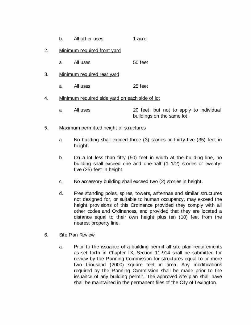
b. All other uses 1 acre
2. Minimum required front yard
a. All uses 50 feet
3. Minimum required rear yard
a. All uses 25 feet
4. Minimum required side yard on each side of lot
a. All uses 20 feet, but not to apply to individual buildings on the same lot.
5. Maximum permitted height of structures
a. No building shall exceed three (3) stories or thirty-five (35) feet in height.
b. On a lot less than fifty (50) feet in width at the building line, no
building shall exceed one and one-half (1 1/2) stories or twenty- five (25) feet in height.
c. No accessory building shall exceed two (2) stories in height.
d. Free standing poles, spires, towers, antennae and similar structures
not designed for, or suitable to human occupancy, may exceed the height provisions of this Ordinance provided they comply with all other codes and Ordinances, and provided that they are located a distance equal to their own height plus ten (10) feet from the nearest property line.
6. Site Plan Review
a. Prior to the issuance of a building permit all site plan requirements as set forth in Chapter IX, Section 11-914 shall be submitted for review by the Planning Commission for structures equal to or more two thousand (2000) square feet in area. Any modifications required by the Planning Commission shall be made prior to the issuance of any building permit. The approved site plan shall have shall be maintained in the permanent files of the City of Lexington.

b. Prior to the issuance of a building permit all site plan requirements as set forth in Chapter IX, Section 11-914 shall be submitted for review and approval by the building inspector and other department directors for structures less than two thousand (2000) square feet, the building inspector and other department directors may review and approve site plans with the option of referring these site plans to the Planning Commission in accordance with 9a.
7. Landscaping - Prior to the issuance of any building permit or Certificate of
Occupancy for a new principal structure, structures, or additions to such structures as Uses Permitted or Uses Permitted on Appeal, the developer shall comply with the provisions in Chapter IX, Section 11-918 of this Ordinance. The Planning Commission or Board of Zoning Appeals will review the landscaping and may require modifications or buffering to minimize the impacts of the project on adjacent development.
11-605. H-M (Hospital-Medical) Districts The purpose and intent of these districts are to provide areas to serve the public health needs of the community recognizing that such facilities have special access and transportation needs.
Within the H-M (Hospital) District as shown on the Zoning Map of Lexington, Tennessee, the following regulations shall apply:
A. Uses Permitted:
1. Hospitals, sanitariums, short-term facilities for care; nursing, convalescent and rest homes, elderly-assisted care and rehabilitation centers.
2. Clinics and medical offices for physicians, dentists, optometrists and other
health care practitioners;
3. Clinical laboratories and public health administration offices, and medical and other technical services related to human care;
4. Pharmacies devoted to the preparation and retailing of drugs, medicines,
and surgical and orthopedic supplies;
5. Accessory uses, limited to the sale of food, beverage, periodicals, and tobacco, for the convenience of employees, patients, and visitors, provided they are located within a permitted use. Advertising of such sales shall be confined to the interior of the building and shall not be visible from the outside of such buildings. Access to any room or enclosure set aside for such sales shall be from the interior of the
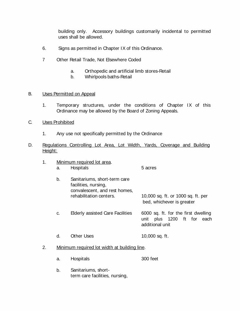
building only. Accessory buildings customarily incidental to permitted uses shall be allowed.
6. Signs as permitted in Chapter IX of this Ordinance.
7 Other Retail Trade, Not Elsewhere Coded
a. Orthopedic and artificial limb stores-Retail b. Whirlpools baths-Retail
B. Uses Permitted on Appeal
1. Temporary structures, under the conditions of Chapter IX of this Ordinance may be allowed by the Board of Zoning Appeals.
C. Uses Prohibited
1. Any use not specifically permitted by the Ordinance D. Regulations Controlling Lot Area, Lot Width, Yards, Coverage and Building
Height:
1. Minimum required lot area. a. Hospitals 5 acres
b. Sanitariums, short-term care
facilities, nursing, convalescent, and rest homes, rehabilitation centers. 10,000 sq. ft. or 1000 sq. ft. per
bed, whichever is greater
c. Elderly assisted Care Facilities 6000 sq. ft. for the first dwelling unit plus 1200 ft for each additional unit
d. Other Uses 10,000 sq. ft.
2. Minimum required lot width at building line.
a. Hospitals 300 feet
b. Sanitariums, short- term care facilities, nursing,
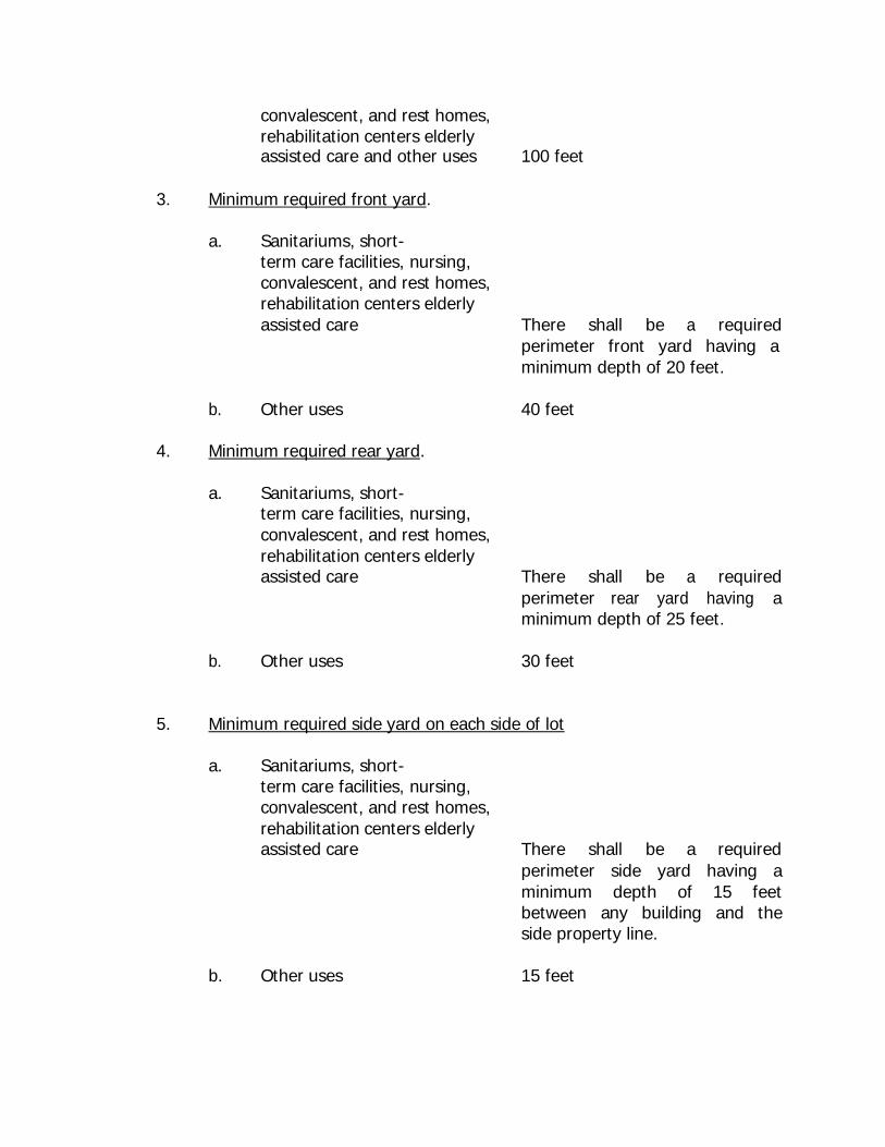
convalescent, and rest homes, rehabilitation centers elderly assisted care and other uses 100 feet
3. Minimum required front yard.
a. Sanitariums, short-
term care facilities, nursing, convalescent, and rest homes, rehabilitation centers elderly assisted care There shall be a required
perimeter front yard having a minimum depth of 20 feet.
b. Other uses 40 feet
4. Minimum required rear yard.
a. Sanitariums, short-
term care facilities, nursing, convalescent, and rest homes, rehabilitation centers elderly assisted care There shall be a required
perimeter rear yard having a minimum depth of 25 feet.
b. Other uses 30 feet
5. Minimum required side yard on each side of lot
a. Sanitariums, short-
term care facilities, nursing, convalescent, and rest homes, rehabilitation centers elderly assisted care There shall be a required
perimeter side yard having a minimum depth of 15 feet between any building and the side property line.
b. Other uses 15 feet
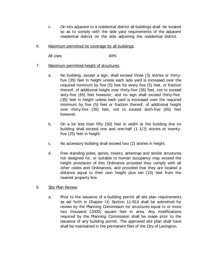
c. On lots adjacent to a residential district all buildings shall be located so as to comply with the side yard requirements of the adjacent residential district on the side adjoining the residential district.
6. Maximum permitted lot coverage by all buildings.
All uses 40%
7. Maximum permitted height of structures.
a. No building, except a sign, shall exceed three (3) stories or thirty- five (35) feet in height unless each side yard is increased over the required minimum by five (5) feet for every five (5) feet, or fraction thereof, of additional height over thirty-five (35) feet, not to exceed sixty-five (65) feet however; and no sign shall exceed thirty-five (35) feet in height unless each yard is increased over the required minimum by five (5) feet or fraction thereof, of additional height over thirty-five (35) feet, not to exceed sixth-five (65) feet however.
b. On a lot less than fifty (50) feet in width at the building line no
building shall exceed one and one-half (1 1/2) stories or twenty- five (25) feet in height.
c. No accessory building shall exceed two (2) stories in height.
d. Free standing poles, spires, towers, antennae and similar structures
not designed for, or suitable to human occupancy may exceed the height provisions of this Ordinance provided they comply with all other codes and Ordinances, and provided that they are located a distance equal to their own height plus ten (10) feet from the nearest property line.
9. Site Plan Review
a. Prior to the issuance of a building permit all site plan requirements as set forth in Chapter IX, Section 11-914 shall be submitted for review by the Planning Commission for structures equal to or more two thousand (2000) square feet in area. Any modifications required by the Planning Commission shall be made prior to the issuance of any building permit. The approved site plan shall have shall be maintained in the permanent files of the City of Lexington.
b. Prior to the issuance of a building permit all site plan requirements as set forth in Chapter IX, Section 11-914 shall be submitted for review and approval by the building inspector and other department directors for structures less than two thousand (2000) square feet, the building inspector and other department directors may review and approve site plans with the option of referring these site plans to the Planning Commission in accordance with 9a.
10. Landscaping - Prior to the issuance of any building permit or Certificate of
Occupancy for a new principal structure, structures, or additions to such structures as Uses Permitted or Uses Permitted on Appeal, the developer shall comply with the provisions in Chapter IX, Section 11-918 of this Ordinance. The Planning Commission or Board of Zoning Appeals will review the landscaping and may require modifications or buffering to minimize the impacts of the project on adjacent development.
11-606. B-M (Business-Industrial) - Districts. The purpose and intent of these districts is to permit a specific variety of retail, wholesale, and manufacturing uses in areas along arterial streets, in which a mixture of such uses has or will develop due to the presence of transportation and utility infrastructure.
Within the B-M (Business-Industrial) Districts as shown on the Zoning Map of Lexington, Tennessee, the following regulations shall apply:
A. Uses Permitted
1. Retail Trade
(a) Building Materials, Hardware and Farm Equipment
(b) General Merchandise
(c) Food
(d) Automotive, Marine Craft, Aircraft and Accessories
(e) Apparel and Accessories
(f) Furniture, Home Furnishing and Equipment
(g) Eating and Drinking
(h) Other Retail Trade, Not Elsewhere Coded limited
(1) Drug and Proprietary (2) Antiques (3) Books and Stationery (4) Sporting Goods and Bicycles (5) Farm and Garden Supplies (6) Jewelry (7) Fuel and Ice (8) Florists (9) Newspaper and Magazines (10) Cigars and Cigarettes (11) Cameras and Photographic Supplies (12) Gifts, Novelties, and Souvenirs (13) Optical Goods (14) Architectural supplies-Retail (15) Art Dealers-Retail (16) Artificial flowers-Retail (17) Artists’ supplies and material stores-Retail (18) Auction rooms (general merchandise) -Retail (19) Autograph and Philatelist supply stores-Retail (20) Awning Shows-Retail (21) Baby Carriages-Retail (22) Banner shops-Retail (23) Binoculars -Retail (24) Cake Decorating Supplies -Retail (25) Candle Shops-Retail (26) Coin Shops-Retail, except for mail order (27) Cosmetic Shops-Retail (28) Electric Razor Shops-Retail (29) Fireworks-Retail (30) Flag Shops-Retail (31) Gems Stones, rough-Retail (32) Gravestones, finished-Retail (33) Hearing Aids-Retail (34) Hot Tubs-Retail (35) Ice Dealers-Retail (36) Monuments, finished to custom order-Retail (37) Orthopedic and artificial limb stores-Retail (38) Pet Food Stores-Retail (39) Pet Shops-Retail (40) Picture Frames, ready made-Retail (41) Police Supply Store-Retail (42) Religious Goods Stores (other than books) -Retail (43) Rock and stone specimens-Retail (44) Rubber stamp stores-Retail
(45) Stamps, philatelist except mail order-Retail (46) Stones crystalline, rough-Retail (47) Swimming Pools, home: not installed-Retail (48) Telephone Stores-Retail (49) Telescopes-Retail (50) Tent shops-Retail (51) Tombstones-Retail (52) Trophy Shops-Retail (53) Typewriter Stores-Retail (54) Whirlpools baths-Retail
2. Wholesale trade -: limited to:
(a) Motor Vehicles and Automotive Equipment
(b) Drugs, Chemicals and Allied products
(c) Dry Goods and Apparel
(d) Groceries and Related Products
(e) Farm Products (Raw Materials), excluding Livestock, Horses and Mules
(f) Electrical Goods
(g) Hardware, Plumbing and Heating Equipment and Supplies
(h) Machinery, Equipment, and Supplies
(i) Other Wholesale Trade, Not Elsewhere Coded - limited to:
(1) Tobacco and Tobacco Products
(2) Beer, Wine and Distilled alcoholic beverages
(3) Paper and Paper Products
(4) Furniture and Home Furnishings
(5) Lumber and Construction Materials
(6) Other Wholesale Trade, Not Elsewhere Coded - excluding Scrap and Waste Materials
3. Services -
(a) Finance, Insurance and Real Estate Services
(b) Personal Services
(c) Business Services, excluding warehousing, storage services, and
stockyards, providing that personal storage (mini-warehousing shall be allowed).
(d) Repair Services including automobile body shops
(e) Professional Services
(f) Contract Construction Services
(g) Governmental Services excluding military bases/reservations
(h) Educational Services
(i) Miscellaneous Services including churches, synagogues, and
temples
(j) Small Animal Clinics excluding livestock, swine, and equine care or any clinic involving outside treatment, recovery, or storage.
4. Manufacturing - limited to:
(a) Food and Kindred Products limited to
(1) Dairy Products
(2) Canning and preserving of fruits and vegetables
(3) Bakery Products
(4) Confectionery and related products
(5) Beverage
(b) Apparel and other Finished Products made from Fabrics, Leather and Similar Materials excluding Leather Tanning and Finishing
(c) Furniture and Fixtures
(d) Professional, Scientific and Controlling Instruments;
Photographic and Optical Goods; Watches and Clocks
5. Veterinarian and Animal Hospital Services
6. Transportation excluding Airports
7. Communication except telecommunications towers (See Uses on Appeal)
8. Utilities
(a) Electric and Water utilities excluding electric generation plants
9. Federal, State and Municipal uses
10. Accessory uses customarily incidental to any permitted use
11. Signs as permitted in Chapter IX of this Ordinance.
12. Assembling incidental to wholesale businesses where products are assembled on the premises from prefabricated parts manufactured off- premises intended for off-site shipment to retailers, other wholesalers and/or service providers where no more than twenty (20) operatives are employed in such operation.
B. Uses Permitted on Appeal
1. Temporary structures under the conditions stated in Chapter IX of this Ordinance may be allowed by the Board of Zoning Appeals.
2. Telecommunications Equipment on Existing Structures Only may be
permitted by the Board of Zoning Appeals upon approval of a proposal which addresses the criteria enumerated Chapter IX, Section 11-918. The approval and the site plan may be subject to such conditions as the Board of Zoning Appeals may require in order to preserve and protect the character of the district in which the proposed use is located. At a minimum, these operations approved shall meet the requirements in Chapter IX, Section 11-918.
C. Uses Prohibited
1. Any use not specifically allowed in this Section. D. Regulations Controlling Lot Area, Lot Width, Yards, Building Coverage and
Building Height
1. Minimum required lot area
a. All uses No minimum requirement
2. Minimum required lot width at the building line
a. All Uses No minimum requirement
3. Minimum required front yard
a. All uses 35 feet
4. Minimum required rear yard
a. All uses 25 feet
5. Minimum required side yard on each side of lot.
a. All uses 25 feet except on lots adjacent to a residential district. All buildings shall be located so as to comply with side yard requirements of adjacent residential district on the side adjacent to the residential district.
6. Maximum Lot Coverage by All Buildings
a. All uses None
7. Maximum Number of Principal Buildings on a Single Lot
a. All uses No maximum providing the provisions of
this Ordinance are met.
8. Maximum permitted height of structures
a. No building shall exceed four (4) stories or forty (40) feet in height.
b. Free standing poles, spires, towers, antennae, and similar structures may exceed the height provisions provided they comply with the provisions of all other codes and Ordinances, and provided that they are located a distance equal to their own height plus ten (10) feet from the nearest property lines.
9. Site Plan Review
a. Prior to the issuance of a building permit all site plan requirements
as set forth in Chapter IX, Section 11-914 shall be submitted for review by the Planning Commission for structures equal to or more two thousand (2000) square feet in area. Any modifications required by the Planning Commission shall be made prior to the issuance of any building permit. The approved site plan shall have shall be maintained in the permanent files of the City of Lexington.
b. Prior to the issuance of a building permit all site plan requirements
as set forth in Chapter IX, Section 11-914 shall be submitted for review and approval by the building inspector and other department directors for structures less than two thousand (2000) square feet, the building inspector and other department directors may review and approve site plans with the option of referring these site plans to the Planning Commission in accordance with 9a.
10. Landscaping - Prior to the issuance of any building permit or Certificate of
Occupancy for a new principal structure, structures, or additions to such structures as Uses Permitted or Uses Permitted on Appeal, the developer shall comply with the provisions in Chapter IX, Section 11-918 of this Ordinance. The Planning Commission or Board of Zoning Appeals will review the landscaping and may require modifications or buffering to minimize the impacts of the project on adjacent development.
CHAPTER VII
PROVISIONS GOVERNING INDUSTRIAL DISTRICTS 11-701. M-1 (Light Industrial) Districts - These districts are designed to provide space for a wide range of industrial and related uses which have the least objectionable characteristics such as noise, smoke, or other omissions thus preventing any adverse impact on neighboring properties. These districts may provide a buffer between other districts and other industrial activities which have more objectionable influences.
Within the M-1 (Light Industrial) Districts as shown on the Official Zoning Map of Lexington, Tennessee, the following regulations shall apply:
A. Uses Permitted
1. Wholesale trade - limited to:
(a) Motor Vehicles and Automotive Equipment
(b) Drugs, Chemicals and Allied products
(c) Dry Goods and Apparel
(d) Groceries and Related Products
(e) Farm Products (Raw Materials), excluding Livestock, Horses and Mules
(f) Electrical Goods
(g) Hardware, plumbing and heating equipment and supplies
(h) Machinery, Equipment, and Supplies
(i) Other Wholesale Trade, Not Elsewhere Coded - limited to:
(1) Tobacco and Tobacco Products
(2) Beer, Wine and Distilled alcoholic beverages
(3) Paper and Paper Products
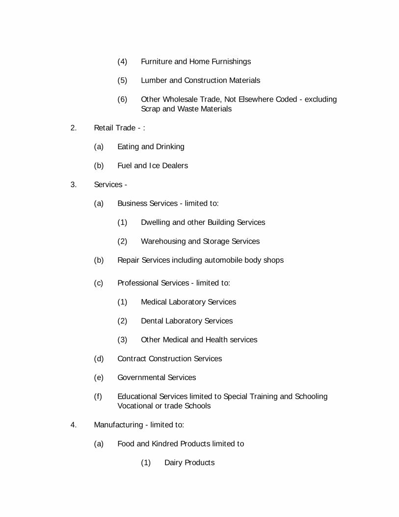
(4) Furniture and Home Furnishings
(5) Lumber and Construction Materials
(6) Other Wholesale Trade, Not Elsewhere Coded - excluding Scrap and Waste Materials
2. Retail Trade - :
(a) Eating and Drinking
(b) Fuel and Ice Dealers
3. Services -
(a) Business Services - limited to:
(1) Dwelling and other Building Services
(2) Warehousing and Storage Services
(b) Repair Services including automobile body shops
(c) Professional Services - limited to:
(1) Medical Laboratory Services
(2) Dental Laboratory Services
(3) Other Medical and Health services
(d) Contract Construction Services
(e) Governmental Services
(f) Educational Services limited to Special Training and Schooling
Vocational or trade Schools
4. Manufacturing - limited to:
(a) Food and Kindred Products limited to
(1) Dairy Products
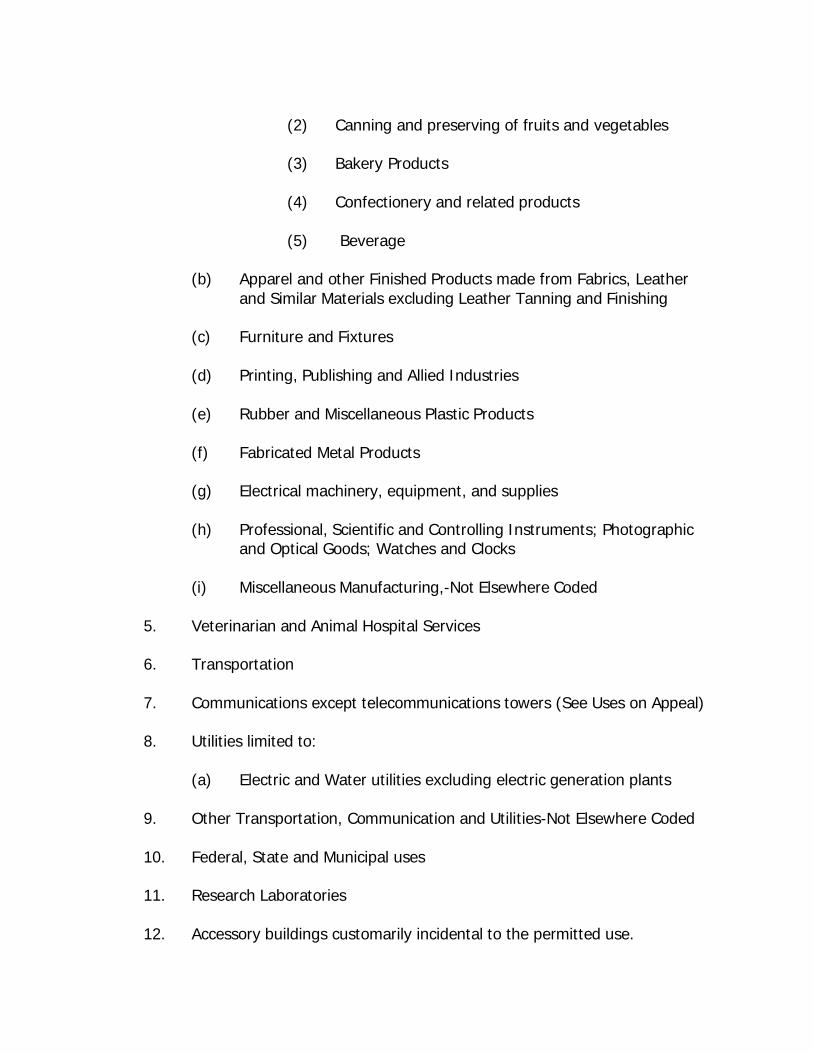
(2) Canning and preserving of fruits and vegetables
(3) Bakery Products
(4) Confectionery and related products
(5) Beverage
(b) Apparel and other Finished Products made from Fabrics, Leather and Similar Materials excluding Leather Tanning and Finishing
(c) Furniture and Fixtures
(d) Printing, Publishing and Allied Industries
(e) Rubber and Miscellaneous Plastic Products
(f) Fabricated Metal Products
(g) Electrical machinery, equipment, and supplies
(h) Professional, Scientific and Controlling Instruments; Photographic
and Optical Goods; Watches and Clocks
(i) Miscellaneous Manufacturing,-Not Elsewhere Coded
5. Veterinarian and Animal Hospital Services
6. Transportation
7. Communications except telecommunications towers (See Uses on Appeal)
8. Utilities limited to:
(a) Electric and Water utilities excluding electric generation plants
9. Other Transportation, Communication and Utilities-Not Elsewhere Coded
10. Federal, State and Municipal uses
11. Research Laboratories
12. Accessory buildings customarily incidental to the permitted use.
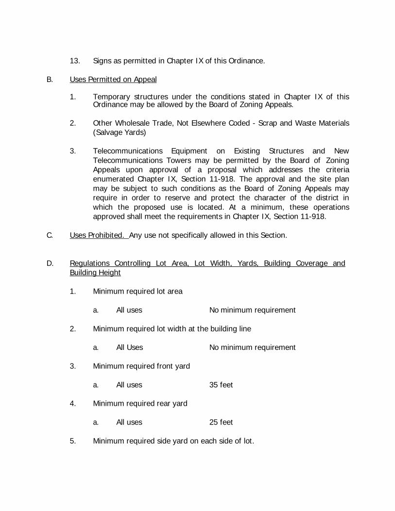
13. Signs as permitted in Chapter IX of this Ordinance. B. Uses Permitted on Appeal
1. Temporary structures under the conditions stated in Chapter IX of this Ordinance may be allowed by the Board of Zoning Appeals.
2. Other Wholesale Trade, Not Elsewhere Coded - Scrap and Waste Materials
(Salvage Yards)
3. Telecommunications Equipment on Existing Structures and New Telecommunications Towers may be permitted by the Board of Zoning Appeals upon approval of a proposal which addresses the criteria enumerated Chapter IX, Section 11-918. The approval and the site plan may be subject to such conditions as the Board of Zoning Appeals may require in order to reserve and protect the character of the district in which the proposed use is located. At a minimum, these operations approved shall meet the requirements in Chapter IX, Section 11-918.
C. Uses Prohibited. Any use not specifically allowed in this Section.
D. Regulations Controlling Lot Area, Lot Width, Yards, Building Coverage and
Building Height
1. Minimum required lot area
a. All uses No minimum requirement
2. Minimum required lot width at the building line
a. All Uses No minimum requirement
3. Minimum required front yard
a. All uses 35 feet
4. Minimum required rear yard
a. All uses 25 feet
5. Minimum required side yard on each side of lot.
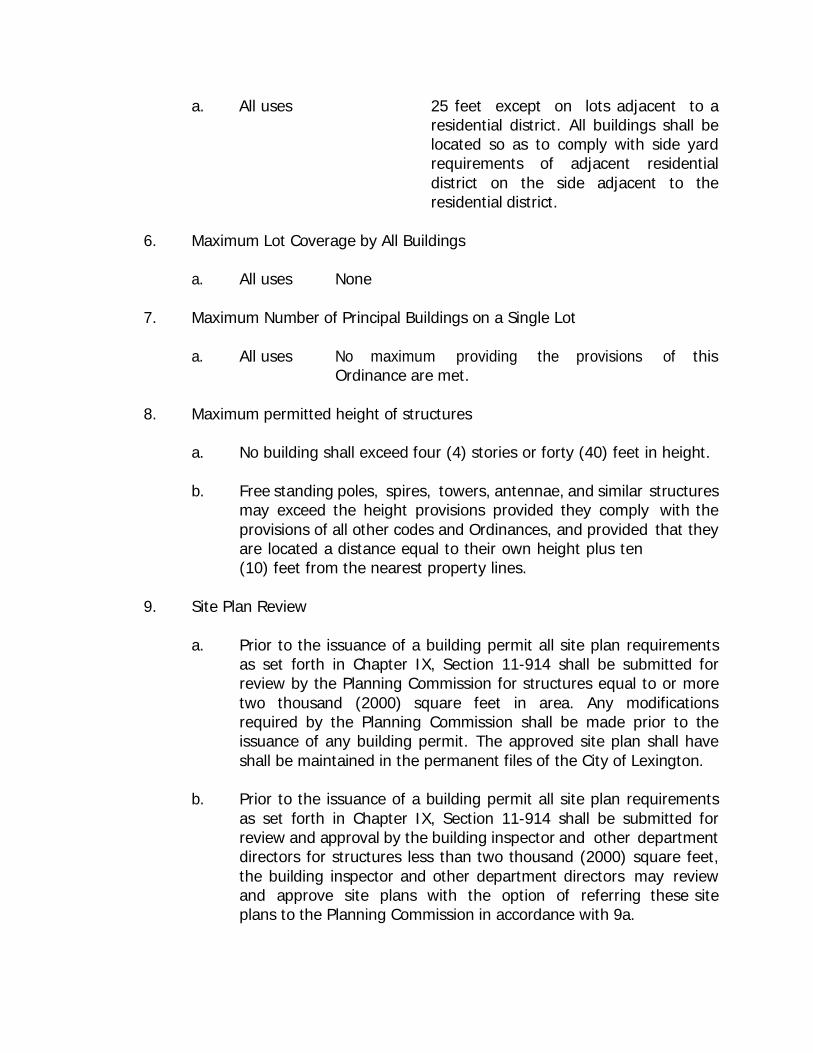
a. All uses 25 feet except on lots adjacent to a residential district. All buildings shall be located so as to comply with side yard requirements of adjacent residential district on the side adjacent to the residential district.
6. Maximum Lot Coverage by All Buildings
a. All uses None
7. Maximum Number of Principal Buildings on a Single Lot
a. All uses No maximum providing the provisions of this
Ordinance are met.
8. Maximum permitted height of structures
a. No building shall exceed four (4) stories or forty (40) feet in height.
b. Free standing poles, spires, towers, antennae, and similar structures may exceed the height provisions provided they comply with the provisions of all other codes and Ordinances, and provided that they are located a distance equal to their own height plus ten (10) feet from the nearest property lines.
9. Site Plan Review
a. Prior to the issuance of a building permit all site plan requirements
as set forth in Chapter IX, Section 11-914 shall be submitted for review by the Planning Commission for structures equal to or more two thousand (2000) square feet in area. Any modifications required by the Planning Commission shall be made prior to the issuance of any building permit. The approved site plan shall have shall be maintained in the permanent files of the City of Lexington.
b. Prior to the issuance of a building permit all site plan requirements
as set forth in Chapter IX, Section 11-914 shall be submitted for review and approval by the building inspector and other department directors for structures less than two thousand (2000) square feet, the building inspector and other department directors may review and approve site plans with the option of referring these site plans to the Planning Commission in accordance with 9a.
10. Landscaping - Prior to the issuance of any building permit or Certificate of Occupancy for a new principal structure, structures, or additions to such structures as Uses Permitted or Uses Permitted on Appeal, the developer shall comply with the provisions in Chapter IX, Section 11-918 of this Ordinance. The Planning Commission or Board of Zoning Appeals will review the landscaping and may require modifications or buffering to minimize the impacts of the project on adjacent development.
11-702. M-2 (Heavy Industrial) Districts - These districts are designed to provide space for a wide range of industrial and related uses which by reasons of volume, scale of operation, type of structures, type of operation, and possible air and water emissions. Due to these factors, these locations will evaluated so minimize the adverse impacts on adjacent properties.
Within the M-2 (Heavy Industrial) Districts as shown on the Zoning Map of Lexington, Tennessee, the following regulations shall apply:
A. Uses Permitted
1. Wholesale trade -: limited to:
(a) Drugs, Chemicals and Allied products
(b) Farm Products (Raw Materials), excluding Livestock, Horses and Mules
(c) Electrical Goods
(d) Machinery, Equipment, and Supplies
(e) Other Wholesale Trade, Not Elsewhere Coded - limited to:
(1.) Lumber and Construction Materials
(2.) Other Wholesale Trade, Not Elsewhere Coded - excluding Scrap and Waste Materials
(3) Metals and Minerals, excluding Petroleum Products and
Scrap
(4) Petroleum Bulk Stations and Terminals
(5) Tobacco and Tobacco Products

(6) Furniture and Home Furnishings
2. Retail Trade - limited to:
(a) Eating and Drinking
(b) Fuel and Ice Dealers
3. Services
(a) Business Services - limited to:
(b) Warehousing and Storage Services, excluding Stockyards
(c) Repair Services including automobile body shops
(d) Contract Construction Services
(e) Governmental Services
(f) Educational Services limited to Special Training and Schooling-
Vocational or Trade Schools
4. Manufacturing – limited to:
(a) Food and Kindred Products limited to
(1) Dairy Products
(2) Canning and preserving of fruits and vegetables
(3) Bakery Products
(4) Confectionery and related products
(5) Beverage
(b) Textile Mill Products
(c) Apparel and other Finished Products made from Fabrics, Leather and similar Materials
(d) Lumber and Wood Products
(e) Furniture and Fixtures
(f) Paper and Allied products, limited to:
(1) Converted Paper and Paperboard Products (except Containers and Boxes)
(2) Paperboard Containers and Boxes
(3) Building Paper and Board Manufacturing
(g) Printing, Publishing and Allied industries
(h) Fabricated Metal Products
(i) Electrical machinery, equipment, and supplies
(j) Professional, Scientific and Controlling Instruments; Photographic
and Optical Goods; Watches and Clocks
(k) Miscellaneous Manufacturing- Not Elsewhere Coded
5. Veterinarian and Animal Hospital Services
6. Transportation
7. Communications except telecommunications towers (See Uses on Appeal).
8. Utilities limited to:
(a) Electric and Water utilities excluding electric generation plants
9. Other Transportation, Communications, and Utilities- Not Elsewhere Coded
10. Federal, State and Municipal uses
11. Research Laboratories
12. Accessory buildings customarily incidental to the permitted use
13. Signs as permitted in Chapter IX of this Ordinance.
B. Uses Permitted on Appeal
1. Temporary structures under the conditions stated in Chapter IX of this Ordinance may be allowed by the Board of Zoning Appeals.
2. Other Wholesale Trade, Not Elsewhere Coded - Scrap and Waste Materials
(Salvage Yards)
3. Utilities not permitted by right including Sewage Disposal and Solid Waste Disposal
4. Food and Kindred Products limited to
(a) Meat Products
(b) Grain Mill products
5. Chemicals and Allied Products, limited to:
(a) Drugs
(b) Soap, Detergents and Cleaning Preparations, Perfume, Cosmetics
and other Toilet Preparations
(c) Paints, Varnishes, Lacquers, Enamels, and Allied Products
6. Industrial Organic Chemicals limited to:
(a) Tanning extracts, tar and tar oils
7. Agricultural Chemicals limited to:
(a) Nitrogenous Fertilizers
(b) Phosphoric Fertilizers
(c) Fertilizers Mixing Only
8. Rubber and Miscellaneous Plastic Products
9. Stone, Clay, Cement and Glass Products
10. Primary Metal Industries
11. Telecommunications Equipment on Existing Structures and New Telecommunications Towers may be permitted by the Board of Zoning Appeals upon approval of a proposal which addresses the criteria enumerated Chapter IX, Section 11-918. The approval and the site plan may be subject to such conditions as the Board of Zoning Appeals may require in order to reserve and protect the character of the district in which the proposed use is located. At a minimum, these operations approved shall meet the requirements in Chapter IX, Section 11-918.
C. Uses Prohibited
1. Any use not specifically allowed in this section. D. Regulations Controlling Lot Area, Lot Width, Yards, Building Coverage and
Building Height
1. Minimum required lot area
a. All uses No minimum requirement
2. Minimum required lot width at the building line
a. All Uses No minimum requirement
3. Minimum required front yard
a. All uses 35 feet
4. Minimum required rear yard
a. All uses 25 feet
5. Minimum required side yards
a. All uses 25 feet except on lots adjacent to a residential district, all buildings shall be
located so as to comply with the side yard requirement of adjacent residential district on the side adjacent to the residential district.
6. Maximum Lot Coverage by All Buildings
a. All uses None
7. Maximum Number of Principal Buildings on a Single Lot
a. All uses No maximum providing the provisions of this Ordinance are met.
8. Maximum permitted height of structures
a. No building may exceed three (4) stories or thirty-five (45) feet in
height.
b. Free standing poles, spires, towers, antennae, and similar structures may exceed the height provisions provided they comply with the provisions of all other codes and Ordinances, and provided that they are located a distance equal to their own height plus ten (10) feet from the nearest property line.
9. Site Plan Review
a. Prior to the issuance of a building permit all site plan requirements
as set forth in Chapter IX, Section 11-914 shall be submitted for review by the Planning Commission for structures equal to or more two thousand (2000) square feet in area. Any modifications required by the Planning Commission shall be made prior to the issuance of any building permit. The approved site plan shall have shall be maintained in the permanent files of the City of Lexington.
b. Prior to the issuance of a building permit all site plan requirements
as set forth in Chapter IX, Section 11-914 shall be submitted for review and approval by the building inspector and other department directors for structures less than two thousand (2000) square feet, the building inspector and other department directors may review and approve site plans with the option of referring these site plans to the Planning Commission in accordance with 9a.
10. Landscaping - Prior to the issuance of any building permit or Certificate of Occupancy for a new principal structure, structures, or additions to such structures as Uses Permitted or Uses Permitted on Appeal, the developer shall comply with the provisions in Chapter IX, Section 11-918 of this Ordinance. The Planning Commission or Board of Zoning Appeals will review the landscaping and may require modifications or buffering to minimize the impacts of the project on adjacent development.
CHAPTER VIII
PROVISIONS GOVERNING FLOOD HAZARD DISTRICTS
11-801. STATUTORY AUTHORIZATION, FINDINGS OF FACT, PURPOSE AND OBJECTIVES
Section A. Statutory Authorization
The Legislature of the State of Tennessee has in Sections 13-7-201 through 13-7-211; Tennessee Code Annotated delegated the responsibility to local governmental units to adopt regulations designed to promote the public health, safety, and general welfare of its citizenry. Therefore, the Lexington, Tennessee Mayor and Board of Aldermen, does ordain as follows:
Section B. Findings of Fact
1. The Lexington Mayor and its Legislative Body wishes to maintain eligibility in the National
Flood Insurance Program and in order to do so must meet the requirements of 60.3 of the Federal Insurance Administration Regulations found at 44 CFR Ch. 1 (10-1-04 Edition).
2. Areas of Lexington are subject to periodic inundation which could result in loss of life
and property, health and safety hazards, disruption of commerce and governmental services, extraordinary public expenditures for flood protection and relief, and impairment of the tax base, all of which adversely affect the public health, safety and general welfare.
3. These flood losses are caused by the cumulative effect of obstructions in floodplains,
causing increases in flood heights and velocities; by uses in flood hazard areas which are vulnerable to floods; or construction which is inadequately elevated, flood-proofed, or otherwise unprotected from flood damages.
Section C. Statement of Purpose It is the purpose of this Ordinance to promote the public health, safety and general welfare, and to minimize public and private losses due to flood conditions in specific areas. This Ordinance is designed to:
1. Restrict or prohibit uses which are vulnerable to water or erosion hazards, or which result
in damaging increases in erosion, flood heights, or velocities; 2. Require that uses vulnerable to floods, including community facilities, be protected
against flood damage at the time of initial construction; 3. Control the alteration of natural floodplains, stream channels, and natural protective
barriers which are involved in the accommodation floodwaters; 4. Control filling, grading, dredging and other development which may increase flood
damage or erosion, and; 5. Prevent or regulate the construction of flood barriers which will unnaturally divert flood
waters or which may increase flood hazards to other lands.
Section D. Objectives
The objectives of this Ordinance are:
1. To protect human life, health and property; 2. To minimize expenditure of public funds for costly flood control projects; 3. To minimize the need for rescue and relief efforts associated with flooding and generally
undertaken at the expense of the general public; 4. To minimize prolonged business interruptions; 5. To minimize damage to public facilities and utilities such as water and gas mains, electric,
telephone and sewer lines, streets and bridges located in floodable areas; 6. To help maintain a stable tax base by providing for the sound use and development of
flood prone areas in such a manner as to minimize blight in flood areas; 7. To ensure that potential homebuyers are notified that property is in a floodable area;
and 8. To maintain eligibility for participation in the National Flood Insurance Program.
11-802. DEFINITIONS Unless specifically defined below, words or phrases used in this Ordinance shall be interpreted as to give them the meaning they have in common usage and to give this Ordinance its most reasonable application given its stated purpose and objectives.
"Accessory Structure" shall represent a subordinate structure to the principal structure and, for the purpose of this section, shall conform to the following:
1. Accessory structures shall not be used for human habitation. 2. Accessory structures shall be designed to have low flood damage potential. 3. Accessory structures shall be constructed and placed on the building site so as to offer
the minimum resistance to the flow of floodwaters. 4. Accessory structures shall be firmly anchored to prevent flotation which may result in
damage to other structures. 5. Service facilities such as electrical and heating equipment shall be elevated or
floodproofed.
"Act" means the statutes authorizing the National Flood Insurance Program that are incorporated in 42 U.S.C. 4001-4128.
"Addition (to an existing building)" means any walled and roofed expansion to the perimeter of a building in which the addition is connected by a common load-bearing wall other than a firewall. Any walled and roofed addition, which is connected by a firewall or is separated by an independent perimeter load-bearing wall, shall be considered “New Construction”.
"Appeal" means a request for a review of the local enforcement officer’s interpretation of any provision of this Ordinance or a request for a variance.
"Area of Shallow Flooding" means a designated AO or AH Zone on a community's Flood Insurance Rate Map (FIRM) with one percent or greater annual chance of flooding to an average depth of one to three feet where a clearly defined channel does not exist, where the path of flooding is unpredictable and indeterminate; and where velocity flow may be evident. (Such flooding is characterized by ponding or sheet flow.)
"Area of Special Flood-related Erosion Hazard" is the land within a community which is most likely to be subject to severe flood-related erosion losses. The area may be designated as Zone E on the Flood Hazard Boundary Map (FHBM). After the detailed evaluation of the special flood-related erosion hazard area in preparation for publication of the FIRM, Zone E may be further refined.
"Area of Special Flood Hazard" is the land in the floodplain within a community subject to a one- percent or greater chance of flooding in any given year. The area may be designated as Zone A on the FHBM. After detailed ratemaking has been completed in preparation for publication of the FIRM, Zone A usually is refined into Zones A, AO, AH, A1-30, AE or A99. "Base Flood" means the flood having a one percent chance of being equaled or exceeded in any given year.
"Basement" means that portion of a building having its floor subgrade (below ground level) on all sides.
"Breakaway Wall" means a wall that is not part of the structural support of the building and is intended through its design and construction to collapse under specific lateral loading forces, without causing damage to the elevated portion of the building or supporting foundation system.
"Building", means any structure built for support, shelter, or enclosure for any occupancy or storage (See "Structure")
"Development" means any man-made change to improved or unimproved real estate, including, but not limited to, buildings or other structures, mining, dredging, filling, grading, paving, excavating, drilling operations, or permanent storage of equipment or materials.
"Elevated Building" means a non-basement building built to have the lowest floor of the lowest enclosed area elevated above the ground level by means of fill, solid foundation perimeter walls with openings sufficient to facilitate the unimpeded movement of floodwater, pilings, columns, piers, or shear walls adequately anchored so as not to impair the structural integrity of the building during a base flood event.
"Emergency Flood Insurance Program" or "Emergency Program" means the program as implemented on an emergency basis in accordance with section 1336 of the Act. It is intended as a program to provide a first layer amount of insurance on all insurable structures before the effective date of the initial FIRM.
"Erosion” means the process of the gradual wearing away of landmasses. This peril is not per se covered under the Program.
"Exception” means a waiver from the provisions of this Ordinance which relieves the applicant from the requirements of a rule, regulation, order or other determination made or issued pursuant to this Ordinance.
"Existing Construction" means any structure for which the "start of construction" commenced before the effective date of the first floodplain management code or ordinance adopted by the community as a basis for that community’s participation in the National Flood Insurance Program (NFIP)).
"Existing Manufactured Home Park or Subdivision" means a manufactured home park or subdivision for which the construction of facilities for servicing the lots on which the manufactured homes are to be affixed (including, at a minimum, the installation of utilities, the construction of streets, final site grading or the pouring of concrete pads) is completed before the effective date of the first floodplain management code or ordinance adopted by the community as a basis for that community’s participation in the National Flood Insurance Program (NFIP)).
"Existing Structures" see "Existing Construction".
"Expansion to an Existing Manufactured Home Park or Subdivision" means the preparation of additional sites by the construction of facilities for servicing the lots on which the manufactured homes are to be affixed (including the installation of utilities, the construction of streets, and either final site grading or the pouring of concrete pads).
"Flood" or "Flooding" means a general and temporary condition of partial or complete inundation of normally dry land areas from:
1. The overflow of inland or tidal waters; 2. The unusual and rapid accumulation or runoff of surface waters from any source.
"Flood Elevation Determination" means a determination by the Administrator of the water surface elevations of the base flood, that is, the flood level that has a one percent or greater chance of occurrence in any given year.
"Flood Elevation Study” means an examination, evaluation and determination of flood hazards and, if appropriate, corresponding water surface elevations, or an examination, evaluation and determination of mudslide (i.e., mudflow) or flood-related erosion hazards.
"Flood Hazard Boundary Map (FHBM)" means an official map of a community, issued by the Federal Emergency Management Agency, where the boundaries of areas of special flood hazard have been designated as Zone A.
"Flood Insurance Rate Map (FIRM)" means an official map of a community, issued by the Federal Emergency Management Agency, delineating the areas of special flood hazard or the risk premium zones applicable to the community.
"Flood Insurance Study" is the official report provided by the Federal Emergency Management Agency, evaluating flood hazards and containing flood profiles and water surface elevation of the base flood.
"Floodplain" or "Flood-prone Area" means any land area susceptible to being inundated by water from any source (see definition of "flooding").
"Floodplain Management” means the operation of an overall program of corrective and preventive measures for reducing flood damage, including but not limited to emergency preparedness plans, flood control works and floodplain management regulations.
"Flood Protection System” means those physical structural works for which funds have been authorized, appropriated, and expended and which have been constructed specifically to modify flooding in order to reduce the extent of the area within a community subject to a "special flood hazard" and the extent of the depths of associated flooding. Such a system typically includes hurricane tidal barriers, dams, reservoirs, levees or dikes. These specialized flood modifying works are those constructed in conformance with sound engineering standards.
"Floodproofing" means any combination of structural and nonstructural additions, changes, or adjustments to structures which reduce or eliminate flood damage to real estate or improved real property, water and sanitary facilities, structures and their contents.
"Flood-related Erosion" means the collapse or subsidence of land along the shore of a lake or other body of water as a result of undermining caused by waves or currents of water exceeding anticipated cyclical levels or suddenly caused by an unusually high water level in a natural body of water, accompanied by a severe storm, or by an unanticipated force of nature, such as a flash flood, or by some similarly unusual and unforeseeable event which results in flooding.
"Flood-related Erosion Area" or "Flood-related Erosion Prone Area" means a land area adjoining the shore of a lake or other body of water, which due to the composition of the shoreline or bank and high water levels or wind-driven currents, is likely to suffer flood-related erosion damage.
"Flood-related Erosion Area Management" means the operation of an overall program of corrective and preventive measures for reducing flood-related erosion damage, including but not limited to emergency preparedness plans, flood-related erosion control works and flood plain management regulations.
"Floodway" means the channel of a river or other watercourse and the adjacent land areas that must be reserved in order to discharge the base flood without cumulatively increasing the water surface elevation more than a designated height.
"Floor" means the top surface of an enclosed area in a building (including basement), i.e., top of slab in concrete slab construction or top of wood flooring in wood frame construction. The term does not include the floor of a garage used solely for parking vehicles.
"Freeboard" means a factor of safety usually expressed in feet above a flood level for purposes of floodplain management. "Freeboard" tends to compensate for the many unknown factors that could contribute to flood heights greater than the height calculated for a selected size flood and floodway conditions, such as wave action, bridge openings and the hydrological effect of urbanization of the watershed.
"Functionally Dependent Use" means a use which cannot perform its intended purpose unless it is located or carried out in close proximity to water. The term includes only docking facilities, port facilities that are necessary for the loading and unloading of cargo or passengers, and ship building and ship repair facilities, but does not include long-term storage or related manufacturing facilities.
"Highest Adjacent Grade" means the highest natural elevation of the ground surface, prior to construction, adjacent to the proposed walls of a structure.
"Historic Structure" means any structure that is:
1. Listed individually in the National Register of Historic Places (a listing maintained by the
U.S. Department of Interior) or preliminary determined by the Secretary of the Interior as meeting the requirements for individual listing on the National Register;
2. Certified or preliminarily determined by the Secretary of the Interior as contributing to
the historical significance of a registered historic district or a district preliminarily determined by the Secretary to qualify as a registered historic district;
3. Individually listed on the Tennessee inventory of historic places and determined as
eligible by states with historic preservation programs which have been approved by the Secretary of the Interior; or
4. Individually listed on a local inventory of historic places and determined as eligible by communities with historic preservation programs that have been certified either:
a. By an approved state program as determined by the Secretary of the Interior, or b. Directly by the Secretary of the Interior.
"Levee" means a man-made structure, usually an earthen embankment, designed and constructed in accordance with sound engineering practices to contain, control, or divert the flow of water so as to provide protection from temporary flooding.
"Levee System" means a flood protection system, which consists of a levee, or levees, and associated structures, such as closure, and drainage devices, which are constructed and operated in accordance with sound engineering practices.
"Lowest Floor" means the lowest floor of the lowest enclosed area, including a basement. An unfinished or flood resistant enclosure used solely for parking of vehicles, building access or storage in an area other than a basement area is not considered a building's lowest floor; provided, that such enclosure is not built so as to render the structure in violation of the applicable non-elevation design requirements of this Ordinance.
"Manufactured Home" means a structure, transportable in one or more sections, which is built on a permanent chassis and designed for use with or without a permanent foundation when attached to the required utilities. The term "Manufactured Home" does not include a "Recreational Vehicle", unless such transportable structures are placed on a site for 180 consecutive days or longer.
"Manufactured Home Park or Subdivision" means a parcel (or contiguous parcels) of land divided into two or more manufactured home lots for rent or sale.
"Map" means the Flood Hazard Boundary Map (FHBM) or the Flood Insurance Rate Map (FIRM) for a community issued by the Agency.
"Mean Sea Level" means the average height of the sea for all stages of the tide. It is used as a reference for establishing various elevations within the floodplain. For the purposes of this Ordinance, the term is synonymous with National Geodetic Vertical Datum (NGVD) or other datum, to which base flood elevations shown on a community's Flood Insurance Rate Map are referenced.
"National Geodetic Vertical Datum (NGVD)" as corrected in 1929 is a vertical control used as a reference for establishing varying elevations within the floodplain.
"New Construction" means any structure for which the "start of construction" commenced after the effective date of this ordinance or the effective date of the first floodplain management ordinance and includes any subsequent improvements to such structure.
"New Manufactured Home Park or Subdivision" means a manufactured home park or subdivision for which the construction of facilities for servicing the lots on which the manufactured homes are to be affixed (including at a minimum, the installation of utilities, the construction of streets, and either final site grading or the pouring of concrete pads) is completed after the effective date of this ordinance or the effective date of the first floodplain management ordinance and includes any subsequent improvements to such structure.
"North American Vertical Datum (NAVD)" as corrected in 1988 is a vertical control used as a reference for establishing varying elevations within the floodplain.
"100-year Flood" see "Base Flood".
"Person" includes any individual or group of individuals, corporation, partnership, association, or any other entity, including State and local governments and agencies.
"Recreational Vehicle" means a vehicle which is:
1. Built on a single chassis; 2. 400 square feet or less when measured at the largest horizontal projection; 3. Designed to be self-propelled or permanently towable by a light duty truck; and 4. Designed primarily not for use as a permanent dwelling but as temporary living quarters
for recreational, camping, travel, or seasonal use. "Regulatory Floodway" means the channel of a river or other watercourse and the adjacent land areas that must be reserved in order to discharge the base flood without cumulatively increasing the water surface elevation more than a designated height.
"Riverine" means relating to, formed by, or resembling a river (including tributaries), stream, brook, etc.
"Special Hazard Area" means an area having special flood, mudslide (i.e., mudflow) and/or flood-related erosion hazards, and shown on an FHBM or FIRM as Zone A, AO, A1-30, AE, A99, or AH.
"Start of Construction" includes substantial improvement, and means the date the building permit was issued, provided the actual start of construction, repair, reconstruction, rehabilitation, addition, placement, or other improvement was within 180 days of the permit date. The actual start means either the first placement of permanent construction of a structure (including a manufactured home) on a site, such as the pouring of slabs or footings, the installation of piles, the construction of columns, or any work beyond the stage of excavation; and includes the placement of a manufactured home on a foundation. (Permanent construction does not include initial land preparation, such as clearing, grading and filling; nor does it include the installation of streets and/or walkways; nor does it include excavation for a basement, footings, piers, or foundations or the erection of temporary forms; nor does it include the installation on the property of accessory buildings, such as garages or sheds, not occupied as dwelling units or not part of the main structure. For a substantial improvement, the actual start of construction means the first alteration of any wall, ceiling, floor, or other structural part of a building, whether or not that alteration affects the external dimensions of the building.
"State Coordinating Agency" The Tennessee Department of Economic and Community Development as designated by the Governor of the State of Tennessee at the request of the Administrator to assist in the implementation of the National Flood Insurance Program for the state.
"Structure", for purposes of this section, means a walled and roofed building that is principally above ground, a manufactured home, a gas or liquid storage tank, or other man-made facilities or infrastructures.
"Substantial Damage" means damage of any origin sustained by a structure whereby the cost of restoring the structure to its before damaged condition would equal or exceed 50 percent of the market value of the structure before the damage occurred.
"Substantial Improvement" means any repairs, reconstruction’s, rehabilitation’s, additions, alterations or other improvements to a structure, taking place during a 5-year period, in which the cumulative cost equals or exceeds fifty percent of the market value of the structure before the "start of construction" of the improvement. The market value of the structure should be (1) the appraised
value of the structure prior to the start of the initial repair or improvement, or (2) in the case of damage, the value of the structure prior to the damage occurring. This term includes structures which have incurred "substantial damage", regardless of the actual repair work performed.
For the purpose of this definition, “Substantial Improvement” is considered to occur when the first alteration of any wall, ceiling, floor or other structural part of the building commences, whether or not that alteration affects the external dimensions of the building. The term does not, however, include either: (1) Any project for improvement of a structure to correct existing violations of state or local health, sanitary, or safety code specifications which have been pre-identified by the local code enforcement official and which are the minimum necessary to assure safe living conditions and not solely triggered by an improvement or repair project or; (2) Any alteration of a "historic structure", provided that the alteration will not preclude the structure's continued designation as a "historic structure".
"Substantially Improved Existing Manufactured Home Parks or Subdivisions" is where the repair, reconstruction, rehabilitation or improvement of the streets, utilities and pads equals or exceeds 50 percent of the value of the streets, utilities and pads before the repair, reconstruction or improvement commenced.
"Variance" is a grant of relief from the requirements of this Ordinance which permits construction in a manner otherwise prohibited by this Ordinance where specific enforcement would result in unnecessary hardship.
"Violation" means the failure of a structure or other development to be fully compliant with the community's floodplain management regulations. A structure or other development without the elevation certificate, other certification, or other evidence of compliance required in this Ordinance is presumed to be in violation until such time as that documentation is provided.
"Water Surface Elevation" means the height, in relation to the National Geodetic Vertical Datum (NGVD) of 1929, (or other datum, where specified) of floods of various magnitudes and frequencies in the floodplains of riverine areas.
11-803. GENERAL PROVISIONS
Section A. Application
This Ordinance shall apply to all areas within the incorporated area of Lexington, Tennessee.
Section B. Basis for Establishing the Areas of Special Flood Hazard
The Areas of Special Flood Hazard identified on the Henderson County, Tennessee and Incorporated Areas, Federal Emergency Management Agency, Flood Insurance Study (FIS) and Flood Insurance Rate Map (FIRM), Community Panel Number Panel Number 47077C0135D; 47077C0137D; 47077C0141D; 47077C0142D; 47077C0143D; 47077C0144D; 47077C0155D; 47077C0161D; 47077C0163D; 47077C0235D; and 47077C0251D; effective: April 16, 2008 along with all supporting technical data, are adopted by reference and declared to be a part of this Ordinance.
Section C. Requirement for Development Permit
A development permit shall be required in conformity with this Ordinance prior to the commencement of any development activities.
Section D. Compliance
No land, structure or use shall hereafter be located, extended, converted or structurally altered without full compliance with the terms of this Ordinance and other applicable regulations.
Section E. Abrogation and Greater Restrictions
This Ordinance is not intended to repeal, abrogate, or impair any existing easements, covenants, or deed restrictions. However, where this Ordinance conflicts or overlaps with another regulatory instrument, whichever imposes the more stringent restrictions shall prevail.
Section F. Interpretation
In the interpretation and application of this Ordinance, all provisions shall be: (1) considered as minimum requirements; (2) liberally construed in favor of the governing body, and; (3) deemed neither to limit nor repeal any other powers granted under Tennessee statutes.
Section G. Warning and Disclaimer of Liability
The degree of flood protection required by this Ordinance is considered reasonable for regulatory purposes and is based on scientific and engineering considerations. Larger floods can and will occur on rare occasions. Flood heights may be increased by man-made or natural causes. This Ordinance does not imply that land outside the Areas of Special Flood Hazard or uses permitted within such areas will be free from flooding or flood damages. This Ordinance shall not create liability on the part of the City of Lexington, Tennessee or by any officer or employee thereof for any flood damages that result from reliance on this Ordinance or any administrative decision lawfully made hereunder.
Section H. Penalties for Violation
Violation of the provisions of this Ordinance or failure to comply with any of its requirements, including violation of conditions and safeguards established in connection with grants of variance shall constitute a misdemeanor punishable as other misdemeanors as provided by law. Each day such violation continues shall be considered a separate offense. Nothing herein contained shall prevent the City of Lexington, Tennessee from taking such other lawful actions to prevent or remedy any violation.
11-804. ADMINISTRATION
Section A. Designation of Ordinance Administrator
The Building Inspector is hereby appointed as the Administrator to implement the provisions of this Ordinance.
Section B. Permit Procedures
Application for a development permit shall be made to the Administrator on forms furnished by the community prior to any development activities. The development permit may include, but is not limited to the following: plans in duplicate drawn to scale and showing the nature, location, dimensions, and elevations of the area in question; existing or proposed structures, earthen fill placement, storage of materials or equipment, and drainage facilities. Specifically, the following information is required:
1. Application stage
a. Elevation in relation to mean sea level of the proposed lowest floor, including
basement, of all buildings where BFE’s are available, or to the highest adjacent grade when applicable under this Ordinance.
b. Elevation in relation to mean sea level to which any non-residential building will be
flood-proofed where BFE’s are available, or to the highest adjacent grade when applicable under this Ordinance.
c. Design certificate from a registered professional engineer or architect that the
proposed non-residential flood-proofed building will meet the flood-proofing criteria in 11-804. Section B.
d. Description of the extent to which any watercourse will be altered or relocated as
a result of proposed development.
2. Construction Stage
Within unnumbered A zones, where flood elevation data are not available, the Administrator shall record the elevation of the lowest floor on the development permit. The elevation of the lowest floor shall be determined as the measurement of the lowest floor of the building relative to the highest adjacent grade.
For all new construction and substantial improvements, the permit holder shall provide to the Administrator an as-built certification of the regulatory floor elevation or floodproofing level upon the completion of the lowest floor or floodproofing. Within unnumbered A zones, where flood elevation data is not available, the elevation of the lowest floor shall be determined as the measurement of the lowest floor of the building relative to the highest adjacent grade.
Any lowest floor certification made relative to mean sea level shall be prepared by or under the direct supervision of, a registered land surveyor and certified by same. When floodproofing is utilized for a non-residential building said certification shall be prepared by or under the direct supervision of, a professional engineer or architect and certified by same.
Any work undertaken prior to submission of the certification shall be at the permit holder's risk. The Administrator shall review the above-referenced certification data. Deficiencies detected by such review shall be corrected by the permit holder immediately

and prior to further work being allowed to proceed. Failure to submit the certification or failure to make said corrections required hereby, shall be cause to issue a stop-work order for the project.
Section C. Duties and Responsibilities of the Administrator
Duties of the Administrator shall include, but not be limited to:
1. Review of all development permits to assure that the permit requirements of this Ordinance have been satisfied, and that proposed building sites will be reasonably safe from flooding.
2. Advice to permittee that additional federal or state permits may be required, and if
specific federal or state permit requirements are known, require that copies of such permits be provided and maintained on file with the development permit. This shall include Section 404 of the Federal Water Pollution Control Act Amendments of 1972, 33 U. S. C. 1334.
3. Notification to adjacent communities and the Tennessee Department of Economic and
Community Development prior to any alteration or relocation of a watercourse, and submission of evidence of such notification to the Federal Emergency Management Agency.
4. For any altered or relocated watercourse, submit engineering data/analysis within six (6)
months to the Federal Emergency Management Agency to ensure accuracy of community flood maps through the Letter of Map Revision process. Assure that the flood carrying capacity within an altered or relocated portion of any watercourse is maintained.
5. Record the elevation, in relation to mean sea level or the highest adjacent grade, where
applicable of the lowest floor including basement of all new or substantially improved buildings, in accordance with 11-804. Section B.
6. Record the actual elevation; in relation to mean sea level or the highest adjacent grade,
where applicable to which the new or substantially improved buildings have been flood-proofed, in accordance with 11-804. Section B.
7. When flood proofing is utilized for a structure, the Administrator shall obtain certification
of design criteria from a registered professional engineer or architect, in accordance with 11-804. Section B.
8. Where interpretation is needed as to the exact location of boundaries of the areas of
special flood hazard (for example, where there appears to be a conflict between a mapped boundary and actual field conditions) the Administrator shall make the necessary interpretation. Any person contesting the location of the boundary shall be given a reasonable opportunity to appeal the interpretation as provided in this Ordinance.
9. When base flood elevation data or floodway data have not been provided by the Federal
Emergency Management Agency then the Administrator shall obtain, review and reasonably utilize any base flood elevation and floodway data available from a Federal, State, or other sources, including data developed as a result of these regulations, as criteria for requiring that new construction, substantial improvements, or other development in Zone A on the Community FIRM meet the requirements of this Ordinance.
Within unnumbered A zones, where base flood elevations have not been established and where alternative data is not available, the Administrator shall require the lowest floor of a building to be elevated or floodproofed to a level of at least three (3) feet above the highest adjacent grade (lowest floor and highest adjacent grade being defined in 11-802 of this Ordinance). All applicable data including elevations or flood proofing certifications shall be recorded as set forth in 11-804. Section B.
10. All records pertaining to the provisions of this Ordinance shall be maintained in the office
of the Administrator and shall be open for public inspection. Permits issued under the provisions of this Ordinance shall be maintained in a separate file or marked for expedited retrieval within combined files.
11-805. PROVISIONS FOR FLOOD HAZARD REDUCTION Section A. General Standards In all flood prone areas the following provisions are required:
1. New construction and substantial improvements to existing buildings shall be anchored
to prevent flotation, collapse or lateral movement of the structure; 2. Manufactured homes shall be elevated and anchored to prevent flotation, collapse, or
lateral movement. Methods of anchoring may include, but are not limited to, use of over-the-top or frame ties to ground anchors. This standard shall be in addition to and consistent with applicable state requirements for resisting wind forces;
3. New construction and substantial improvements to existing buildings shall be
constructed with materials and utility equipment resistant to flood damage; 4. New construction or substantial improvements to existing buildings shall be constructed
by methods and practices that minimize flood damage; 5. All electrical, heating, ventilation, plumbing, air conditioning equipment, and other
service facilities shall be designed and/or located so as to prevent water from entering or accumulating within the components during conditions of flooding;
6. New and replacement water supply systems shall be designed to minimize or eliminate
infiltration of flood waters into the system; 7. New and replacement sanitary sewage systems shall be designed to minimize or
eliminate infiltration of flood waters into the systems and discharges from the systems into flood waters;
8. On-site waste disposal systems shall be located and constructed to avoid impairment to
them or contamination from them during flooding; 9. Any alteration, repair, reconstruction or improvements to a building that is in compliance
with the provisions of this Ordinance, shall meet the requirements of "new construction" as contained in this Ordinance; and,
10. Any alteration, repair, reconstruction or improvements to a building that is not in
compliance with the provision of this Ordinance, shall be undertaken only if said non-conformity is not further extended or replaced.
Section B. Specific Standards
These provisions shall apply to ALL Areas of Special Flood Hazard as provided herein:
1. Residential Construction. Where base flood elevation data is available, new construction
or substantial improvement of any residential building (or manufactured home) shall have the lowest floor, including basement, elevated no lower than one (1) foot above the base flood elevation. Should solid foundation perimeter walls be used to elevate a structure, openings sufficient to facilitate equalization of flood hydrostatic forces on both sides of exterior walls and to ensure unimpeded movement of floodwater shall be provided in accordance with the standards of 11-805. Section B.
Within unnumbered A zones, where base flood elevations have not been established and where alternative data is not available, the Administrator shall require the lowest floor of a building to be elevated or floodproofed to a level of at least three (3) feet above the highest adjacent grade (lowest floor and highest adjacent grade being defined in 11-802 of this Ordinance). All applicable data including elevations or flood proofing certifications shall be recorded as set forth in 11-804. Section B.
2. Non-Residential Construction. New construction or substantial improvement of any
commercial, industrial, or non-residential building, when BFE data is available, shall have the lowest floor, including basement, elevated or floodproofed no lower than one (1) foot above the level of the base flood elevation.
Within unnumbered A zones, where base flood elevations have not been established and where alternative data is not available, the Administrator shall require the lowest floor of a building to be elevated or floodproofed to a level of at least three (3) feet above the highest adjacent grade (lowest floor and highest adjacent grade being defined in 11-802 of this Ordinance). All applicable data including elevations or flood proofing certifications shall be recorded as set forth in 11-804. Section B.
Buildings located in all A-zones may be flood-proofed, in lieu of being elevated, provided that all areas of the building below the required elevation are watertight, with walls substantially impermeable to the passage of water, and are built with structural components having the capability of resisting hydrostatic and hydrodynamic loads and the effects of buoyancy. A registered professional engineer or architect shall certify that the design and methods of construction are in accordance with accepted standards of practice for meeting the provisions above, and shall provide such certification to the Administrator as set forth in 11-804. Section B.
3. Elevated Building. All new construction or substantial improvements to existing buildings
that include ANY fully enclosed areas formed by foundation and other exterior walls below the base flood elevation, or required height above the highest adjacent grade, shall be designed to preclude finished living space and designed to allow for the entry and exit of flood waters to automatically equalize hydrostatic flood forces on exterior walls.
a. Designs for complying with this requirement must either be certified by a
professional engineer or architect or meet the following minimum criteria.
1) Provide a minimum of two openings having a total net area of not less than one square inch for every square foot of enclosed area subject to flooding;
2) The bottom of all openings shall be no higher than one foot above the finish
grade; and
3) Openings may be equipped with screens, louvers, valves or other coverings
or devices provided they permit the automatic flow of floodwaters in both directions.
b. Access to the enclosed area shall be the minimum necessary to allow for parking
of vehicles (garage door) or limited storage of maintenance equipment used in connection with the premises (standard exterior door) or entry to the elevated living area (stairway or elevator); and
c. The interior portion of such enclosed area shall not be partitioned or finished into
separate rooms in such a way as to impede the movement of floodwaters and all such petitions shall comply with the provisions of 11-805. Section B. of this Ordinance.
4. Standards for Manufactured Homes and Recreational Vehicles
a. All manufactured homes placed, or substantially improved, on: (1) individual lots
or parcels, (2) in expansions to existing manufactured home parks or subdivisions, or (3) in new or substantially improved manufactured home parks or subdivisions, must meet all the requirements of new construction, including elevations and anchoring.
b. All manufactured homes placed or substantially improved in an existing
manufactured home park or subdivision must be elevated so that either:
1) When base flood elevations are available the lowest floor of the manufactured home is elevated on a permanent foundation no lower than one (1) foot above the level of the base flood elevation; or,
2) Absent base flood elevations the manufactured home chassis is elevated and
supported by reinforced piers (or other foundation elements) at least three (3) feet in height above the highest adjacent grade.
c. Any manufactured home, which has incurred “substantial damage” as the result of
a flood or that has substantially improved, must meet the standards of 11-805. Section B. 4 of this Ordinance.
d. All manufactured homes must be securely anchored to an adequately anchored
foundation system to resist flotation, collapse and lateral movement. e. All recreational vehicles placed on identified flood hazard sites must either:
1) Be on the site for fewer than 180 consecutive days; 2) Be fully licensed and ready for highway use. (A recreational vehicle is ready
for highway use if it is licensed, on its wheels or jacking system, attached to the site only by quick disconnect type utilities and security devices, and has no permanently attached structures or additions.
3) The recreational vehicle must meet all the requirements for new construction,
including the anchoring and elevation requirements of this section above if on the site for longer than 180 consecutive days.
5. Standards for Subdivisions
Subdivisions and other proposed new developments, including manufactured home parks, shall be reviewed to determine whether such proposals will be reasonably safe from flooding. If a subdivision proposal or other proposed new development is in a flood-prone area, any such proposals shall be reviewed to ensure that:
a. All subdivision proposals shall be consistent with the need to minimize flood
damage. b. All subdivision proposals shall have public utilities and facilities such as sewer, gas,
electrical and water systems located and constructed to minimize or eliminate flood damage.
c. All subdivision proposals shall have adequate drainage provided to reduce
exposure to flood hazards. d. Base flood elevation data shall be provided for subdivision proposals and other
proposed developments (including manufactured home parks and subdivisions) that are greater than fifty lots and/or five acres in area.
Section C. Standards for Areas of Special Flood Hazard with Established Base Flood Elevations
and With Floodways Designated Located within the Areas of Special Flood Hazard established in 11-803. Section B, are areas designated as floodways. A floodway may be an extremely hazardous area due to the velocity of floodwaters, debris or erosion potential. In addition, the area must remain free of encroachment in order to allow for the discharge of the base flood without increased flood heights and velocities. Therefore, the following provisions shall apply:
1. Encroachments are prohibited, including earthen fill material, new construction,
substantial improvements or other developments within the regulatory floodway. Development may be permitted however, provided it is demonstrated through hydrologic and hydraulic analyses performed in accordance with standard engineering practices that the cumulative effect of the proposed encroachments or new development, when combined with all other existing and anticipated development, shall not result in ANY increase the water surface elevation of the base flood level, velocities or floodway widths during the occurrence of a base flood discharge at any point within the community. A registered professional engineer must provide supporting technical data and certification thereof.
2. New construction or substantial improvements of buildings shall comply with all
applicable flood hazard reduction provisions of 11-805. Section D. Standards for Areas of Special Flood Hazard Zones AE with Established Base Flood
Elevations but Without Floodways Designated Located within the Areas of Special Flood Hazard established in 11-803. Section B, where streams exist with base flood data provided but where no floodways have been designated, (Zones AE) the following provisions apply:
1. No encroachments, including fill material, new structures or substantial improvements
shall be located within areas of special flood hazard, unless certification by a registered professional engineer is provided demonstrating that the cumulative effect of the proposed development, when combined with all other existing and anticipated development, will not increase the water surface elevation of the base flood more than one (1) foot at any point within the community. The engineering certification should be supported by technical data that conforms to standard hydraulic engineering principles.
2. New construction or substantial improvements of buildings shall be elevated or flood-
proofed to elevations established in accordance with 11-805. Section B.
Section E. Standards for Streams without Established Base Flood Elevations or Floodways (A Zones)
Located within the Areas of Special Flood Hazard established in 11-803, where streams exist, but no base flood data has been provided (A Zones), OR where a Floodway has not been delineated, the following provisions shall apply:
1. When base flood elevation data or floodway data have not been provided in accordance
with 11-803, then the Administrator shall obtain, review and reasonably utilize any scientific or historic base flood elevation and floodway data available from a Federal, State or other source, in order to administer the provisions of 11-805. ONLY if data is not available from these sources, then the following provisions (2 & 3) shall apply:
2. No encroachments, including structures or fill material, shall be located within an area equal to the width of the stream or twenty feet, whichever is greater, measured from the top of the stream bank, unless certification by registered professional engineer is provided demonstrating that the cumulative effect of the proposed development, when combined with all other existing and anticipated development, will not increase the water surface elevation of the base flood more than one (1) foot at any point within the community. The engineering certification should be supported by technical data that conforms to standard hydraulic engineering principles.
3. In special flood hazard areas without base flood elevation data, new construction or
substantial improvements of existing shall have the lowest floor of the lowest enclosed area (including basement) elevated no less than three (3) feet above the highest adjacent grade at the building site. Openings sufficient to facilitate the unimpeded movements of floodwaters shall be provided in accordance with the standards of 11-805, Section B, and “Elevated Buildings".
Section F. Standards For Areas of Shallow Flooding (AO and AH Zones) Located within the Areas of Special Flood Hazard established in 11-803, Section B, are areas designated as shallow flooding areas. These areas have special flood hazards associated with base flood depths of one to three feet (l'-3') where a clearly defined channel does not exist and where the path of flooding is unpredictable and indeterminate; therefore, the following provisions apply:
1. All new construction and substantial improvements of residential and non-residential buildings shall have the lowest floor, including basement, elevated to at least one (1’) foot above the flood depth number specified on the Flood Insurance Rate Map (FIRM), in feet, above the highest adjacent grade. If no flood depth number is specified, the lowest floor, including basement, shall be elevated, at least three (3) feet above the highest adjacent grade. Openings sufficient to facilitate the unimpeded movements of floodwaters shall be provided in accordance with standards of 11-805, Section B, and “Elevated Buildings".
2. All new construction and substantial improvements of nonresidential buildings may be
flood-proofed in lieu of elevation. The structure together with attendant utility and sanitary facilities must be flood proofed and designed watertight to be completely flood-proofed to at least one (1’) foot above the specified FIRM flood level, with walls substantially impermeable to the passage of water and with structural components having the capability of resisting hydrostatic and hydrodynamic loads and the effects of buoyancy. If no depth number is specified, the lowest floor, including basement, shall
be flood proofed to at least three (3) feet above the highest adjacent grade. A registered professional engineer or architect shall certify that the design and methods of construction are in accordance with accepted standards of practice for meeting the provisions of this ordinance and shall provide such certification to the Administrator as set forth above and as required in 11-804, Section B.
3. Adequate drainage paths shall be provided around slopes to guide floodwaters around
and away from proposed structures. 4. The Administrator shall certify the elevation or the highest adjacent grade, where
applicable, and the record shall become a permanent part of the permit file.
Section G. Standards For Areas Protected by Flood Protection System (A-99 Zones) Located within the areas of special flood hazard established in 11-803. Are areas of the 100-year floodplain protected by a flood protection system but where base flood elevations and flood hazard factors have not been determined. Within these areas (A-99 Zones) all provisions of 11-804. And 11-805. Section A. shall apply.
Section H. Standards for Unmapped Streams
Located within Lexington, Tennessee are unmapped streams where areas of special flood hazard are neither indicated nor identified. Adjacent to such streams the following provisions shall apply:
1. In areas adjacent to such unmapped streams, no encroachments including fill material
or structures shall be located within an area of at least equal to twice the width of the stream, measured from the top of each stream bank, unless certification by a registered professional engineer is provided demonstrating that the cumulative effect of the proposed development, when combined with all other existing and anticipated development, will not increase the water surface elevation of the base flood more than one (1) foot at any point within the Lexington.
2. When new elevation data is available, new construction or substantial improvements of
buildings shall be elevated or flood proofed to elevations established in accordance with 11-804.
11-806. VARIANCE PROCEDURES
The provisions of this section shall apply exclusively to areas of Special Flood Hazard within Lexington, Tennessee.
Section A. Board of Zoning Appeals
1. The Lexington Board of Zoning Appeals shall hear and decide appeals and requests for
variances from the requirements of this Ordinance. 2. Variances may be issued for the repair or rehabilitation of historic structures (see
definition) upon a determination that the proposed repair or rehabilitation will not preclude the structure's continued designation as a historic structure and the variance is the minimum to preserve the historic character and design of the structure.
3. In passing upon such applications, the Board of Zoning Appeals shall consider all technical evaluations, all relevant factors, all standards specified in other sections of this Ordinance, and:
a. The danger that materials may be swept onto other property to the injury of others; b. The danger to life and property due to flooding or erosion; c. The susceptibility of the proposed facility and its contents to flood damage; d. The importance of the services provided by the proposed facility to the community; e. The necessity of the facility to a waterfront location, in the case of a functionally
dependent facility; f. The availability of alternative locations, not subject to flooding or erosion damage,
for the proposed use; g. The relationship of the proposed use to the comprehensive plan and floodplain
management program for that area; h. The safety of access to the property in times of flood for ordinary and emergency
vehicles; i. The expected heights, velocity, duration, rate of rise and sediment transport of the
flood waters and the effects of wave action, if applicable, expected at the site, and; j. The costs of providing governmental services during and after flood conditions
including maintenance and repair of public utilities and facilities such as sewer, gas, electrical, and water systems, and streets and bridges.
4. Upon consideration of the factors listed above, and the purposes of this Ordinance, the
Board of Floodplain Review may attach such conditions to the granting of variances as it deems necessary to effectuate the purposes of this Ordinance.
5. Variances shall not be issued within any designated floodway if any increase in flood
levels during the base flood discharge would result. Section B. Conditions for Variances
1. Variances shall be issued upon a determination that the variance is the minimum relief necessary, considering the flood hazard; and in the instance of a historical building, a determination that the variance is the minimum relief necessary so as not to destroy the historic character and design of the building.
2. Variances shall only be issued upon: a showing of good and sufficient cause, a
determination that failure to grant the variance would result in exceptional hardship; or a determination that the granting of a variance will not result in increased flood heights, additional threats to public safety, extraordinary public expense, create nuisance, cause fraud on or victimization of the public, or conflict with existing local laws or Ordinances.
3. Any applicant to whom a variance is granted shall be given written notice that the
issuance of a variance to construct a structure below the base flood level will result in increased premium rates for flood insurance, and that such construction below the base flood level increases risks to life and property.
4. The Administrator shall maintain the records of all appeal actions and report any variances to the Federal Emergency Management Agency upon request.
11-807. LEGAL STATUS PROVISIONS
Section A. Conflict with Other Ordinances
In case of conflict between this Ordinance or any part thereof, and the whole or part of any existing or future Ordinance of Lexington, Tennessee, the most restrictive shall in all cases apply.
Section B. Validity
If any section, clause, provision, or portion of this Ordinance shall be held to be invalid or unconstitutional by any court of competent jurisdiction, such holding shall not affect any other section, clause, provision, or portion of this Ordinance which is not of itself invalid or unconstitutional.
Section C. Effective Date
This Ordinance shall become effective immediately after its passage, in accordance with the Charter of Lexington, Tennessee, and the public welfare demanding it.
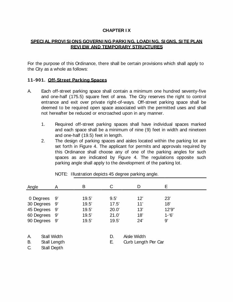
CHAPTER IX
SPECIAL PROVISIONS GOVERNING PARKING, LOADING, SIGNS, SITE PLAN REVIEW AND TEMPORARY STRUCTURES
For the purpose of this Ordinance, there shall be certain provisions which shall apply to the City as a whole as follows:
11-901. Off-Street Parking Spaces
A. Each off-street parking space shall contain a minimum one hundred seventy-five and one-half (175.5) square feet of area. The City reserves the right to control entrance and exit over private right-of-ways. Off-street parking space shall be deemed to be required open space associated with the permitted uses and shall not hereafter be reduced or encroached upon in any manner.
1. Required off-street parking spaces shall have individual spaces marked
and each space shall be a minimum of nine (9) feet in width and nineteen and one-half (19.5) feet in length.
2. The design of parking spaces and aisles located within the parking lot are set forth in Figure 4. The applicant for permits and approvals required by this Ordinance shall choose any of one of the parking angles for such spaces as are indicated by Figure 4. The regulations opposite such parking angle shall apply to the development of the parking lot.
NOTE: Illustration depicts 45 degree parking angle.
Angle A
B
C
D
E
0 Degrees 9’
30 Degrees 9’ 45 Degrees 9’ 60 Degrees 9’ 90 Degrees 9’
19.5’ 19.5’ 19.5’ 19.5’ 19.5’
9.5’ 17.5’ 20.0’ 21.0’ 19.5’
12’ 11’ 13’ 18’ 24’
23’ 18’ 12’9” 1-‘6’ 9’
A. Stall Width B. Stall Length C. Stall Depth
D. E.
Aisle Width Curb Length Per Car
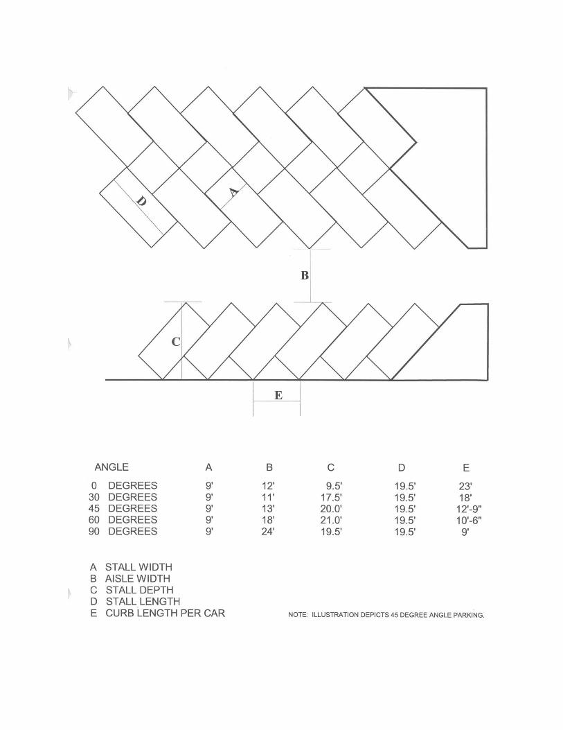
B. A parking space is required for a portion of unit measurement one half or more of the amount set forth herein.
C. Parking spaces maintained in connection with an existing and continuing main
building or structure on the effective date of this Ordinance, shall be continued and may not be counted as serving a new structure or addition.
D. A residential off-street parking space shall consist of a driveway and either a
parking space, carport or garage and shall be located on the lot it is intended to serve.
E. A required parking area under this section, which includes parking spaces, drives
and maneuvering lanes, shall be provided with six inch (6") concrete curbs and twenty-four inch (24") concrete gutters. The parking area shall be of an asphalt or concrete paved surface and shall be surfaced within six (6) months of the date of completion of building construction. This requirement does not apply to a single family or two family structures on a single lots.
F. Parking spaces maintained in connection with an existing and continuing main
building or structure on the effective date of this Ordinance shall be continued but may not be counted as serving a new structure or addition, nor may any parking space be substituted for a loading space, nor any loading space substituted for a parking space.
G. If the off-street parking space required above cannot be reasonably provided on
the same lot on which the principal use is conducted, the Board of Zoning Appeals may permit such space to be provided on other off-street property provided such space lies within four hundred (400) feet of the main entrance to such principal use. Such vehicle standing space shall be deemed to be required open space associated with the permitted use and shall not thereafter be reduced or encroached upon in any manner.
H. The district zoned as the B-3 (Central Business) District, shall be exempt from
supplying parking spaces as required herein.
11-902 The Minimum Off-Street Parking Requirements are as follows:
A. Dwelling, Multi-family 1.5 spaces for each one bedroom unit; 2.0 spaces for each two
bedroom unit, and 3.0 spaces for each unit having four or more bedrooms
B. Hotels, motels, tourist Courts and similar transient lodging
One (1) space per unit plus one space per each two (2) employees
C. Retail Trade One (1) space per 200 square foot of total floor area
D. Wholesale Trade One (1) space per 1,000 square foot of total floor area
E. Public Assembly
1. Movie and other theaters and other places of Public Assembly
One (1) space for each three (3) seats in the main auditorium or one (1) space for each 50 square feet of seating floor area if seating is not fixed
2. Sports Assembly One (1) space for each three (3) seats or six (6) feet of benches.
3. Religious Activities One (1) space per four (4) seats in the auditorium
4. Restaurants, Taverns, Nightclubs One (1) space per 150 square feet of floor area or one space per two employees on the largest shift, which-ever is greater
F. Finance Insurance and Real Estate
1. Banks, savings and loans, real estate Offices, and insurance One (1) space per 250 sq. ft of
Total floor area.
G. Services
1. Advertising, consumer credit reporting and collections One (1) space per 400 sq. ft. of
total floor area.
2. Attorneys, accountants, engineers One (1) space per 300 sq. ft. of total floor area.
3. Physicians, dentists offices and clinics One (1) space per 150 sq. ft. of total floor area.
4. Beauty ,Barber and photographic One (1) space per 200 sq. ft. of
Services total floor area and 1 space Per employee
5. Group Day care and child care centers 1.5 spaces per care room with a
minimum of 5 spaces plus a paved unobstructed pick-up area with adequate stacking area
6. Family day care homes 1.5 spaces per care room with a
minimum of 3 spaces
7. Elementary school or junior high school One (1) space for each classroom, plus 1 space for each staff member and employee other than teachers, plus ten (10) additional spaces. This provision is not applicable where parking space required for an auditorium is provided.
8. Funeral home or mortuary One (1) space per 250 sq. ft. of
floor area
9. Hospitals and sanitariums One (1) space for each bed plus 1 per employee.
10. Senior high school One (1) space for each classroom
plus 1 space for each staff member and employee other than teachers, plus 1 space for each seven (76) students based on the building capacity.
11. Automobile Oil Change and Gas Stations One space per 150 sq. ft. of gross
floor area or three (3) spaces per repair bay, whichever is greater.
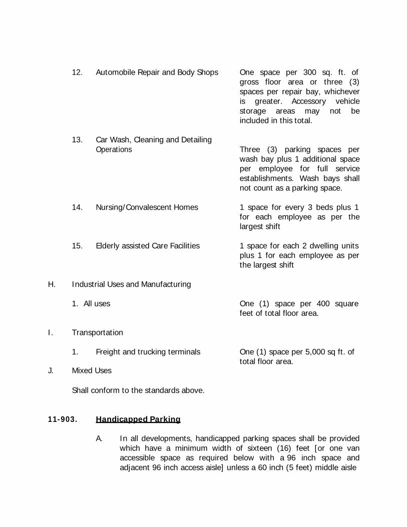
12. Automobile Repair and Body Shops One space per 300 sq. ft. of gross floor area or three (3) spaces per repair bay, whichever is greater. Accessory vehicle storage areas may not be included in this total.
13. Car Wash, Cleaning and Detailing
Operations Three (3) parking spaces per wash bay plus 1 additional space per employee for full service establishments. Wash bays shall not count as a parking space.
14. Nursing/Convalescent Homes 1 space for every 3 beds plus 1
for each employee as per the largest shift
15. Elderly assisted Care Facilities 1 space for each 2 dwelling units
plus 1 for each employee as per the largest shift
H. Industrial Uses and Manufacturing
1. All uses One (1) space per 400 square
feet of total floor area. I. Transportation
1. Freight and trucking terminals One (1) space per 5,000 sq ft. of
total floor area. J. Mixed Uses
Shall conform to the standards above.
11-903. Handicapped Parking
A. In all developments, handicapped parking spaces shall be provided which have a minimum width of sixteen (16) feet [or one van accessible space as required below with a 96 inch space and adjacent 96 inch access aisle] unless a 60 inch (5 feet) middle aisle
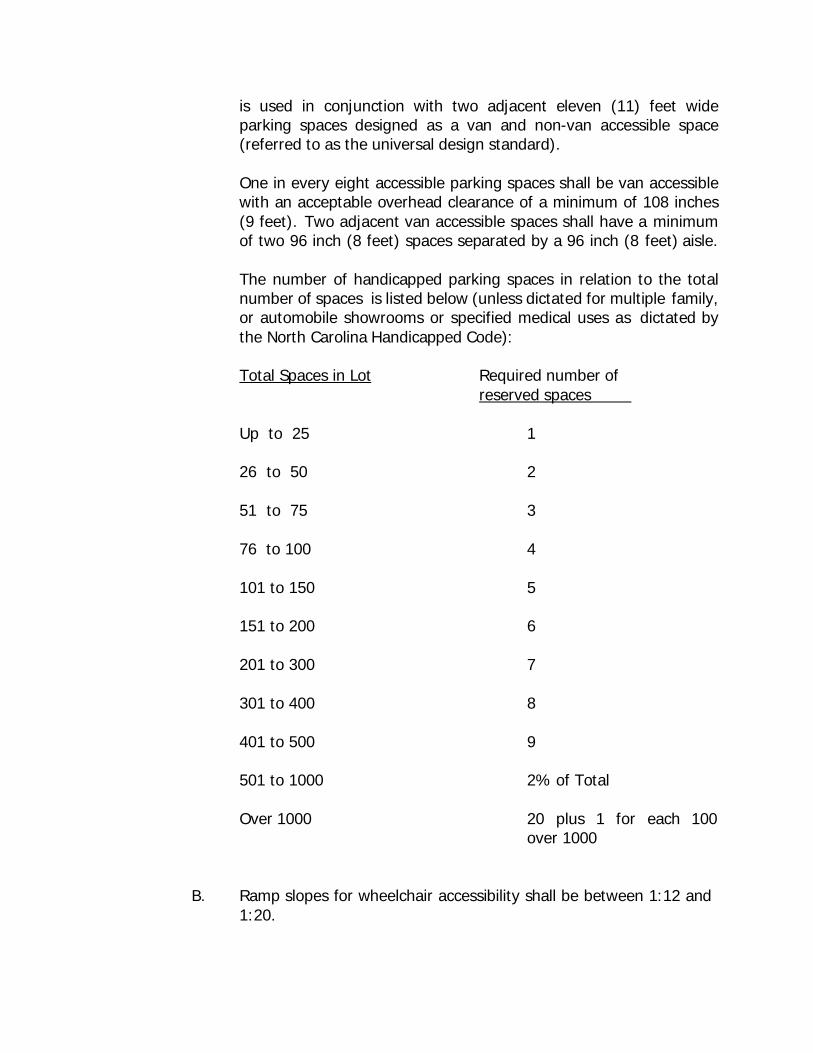
is used in conjunction with two adjacent eleven (11) feet wide parking spaces designed as a van and non-van accessible space (referred to as the universal design standard).
One in every eight accessible parking spaces shall be van accessible with an acceptable overhead clearance of a minimum of 108 inches (9 feet). Two adjacent van accessible spaces shall have a minimum of two 96 inch (8 feet) spaces separated by a 96 inch (8 feet) aisle.
The number of handicapped parking spaces in relation to the total number of spaces is listed below (unless dictated for multiple family, or automobile showrooms or specified medical uses as dictated by the North Carolina Handicapped Code):
Total Spaces in Lot Required number of reserved spaces
Up to 25 1
26 to 50 2
51 to 75 3
76 to 100 4
101 to 150 5
151 to 200 6
201 to 300 7
301 to 400 8
401 to 500 9
501 to 1000 2% of Total
Over 1000 20 plus 1 for over 1000
each 100
B. Ramp slopes for wheelchair accessibility shall be between 1:12 and 1:20.
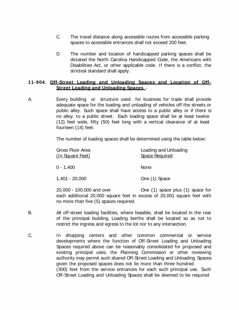
C. The travel distance along accessible routes from accessible parking spaces to accessible entrances shall not exceed 200 feet.
D. The number and location of handicapped parking spaces shall be
dictated the North Carolina Handicapped Code, the Americans with Disabilities Act, or other applicable code. If there is a conflict, the strictest standard shall apply.
11-904. Off-Street Loading and Unloading Spaces and Location of Off-
Street Loading and Unloading Spaces - A. Every building or structure used for business for trade shall provide
adequate space for the loading and unloading of vehicles off the streets or public alley. Such space shall have access to a public alley or if there is no alley, to a public street. Each loading space shall be at least twelve (12) feet wide, fifty (50) feet long with a vertical clearance of at least fourteen (14) feet.
The number of loading spaces shall be determined using the table below:
Gross Floor Area Loading and Unloading (In Square Feet) Space Required
0 - 1,400 None
1,401 - 20,000 One (1) Space
20,000 - 100,000 and over One (1) space plus (1) space for each additional 20,000 square feet in excess of 20,001 square feet with no more than five (5) spaces required.
B. All off-street loading facilities, where feasible, shall be located in the rear
of the principal building. Loading berths shall be located so as not to restrict the ingress and egress to the lot nor to any intersection.
C. In shopping centers and other common commercial or service
developments where the function of Off-Street Loading and Unloading Spaces required above can be reasonably consolidated for proposed and existing principal uses, the Planning Commission or other reviewing authority may permit such shared Off-Street Loading and Unloading Spaces given the proposed spaces does not lie more than three hundred (300) feet from the service entrances for each such principal use. Such Off-Street Loading and Unloading Spaces shall be deemed to be required
open space associated with each permitted use and shall not thereafter be reduced or encroached upon in any manner unless replaced by required Off-Street Loading and Unloading Spaces or moved to a common accessible location on the premises.
The maintenance, access, and other similar issues for such shared Off- Street Loading and Unloading Spaces shall be specified and defined in deed restrictions, accompanying subdivision plats, and other appropriate legal agreements. Proof of such agreements shall be secured in writing prior to approval of the Planning Commission or other reviewing authority.
11-905. Screening for Parking and Loading Spaces
All permitted or required open off-street parking lots and loading berths for commercial and industrial uses located adjacent to residences or a residential district or within a residential district shall be screened for the adjoining residential districts by either:
A. A strip at least 10 feet wide, densely planted with shrubs or trees which are at
least 4 feet high at the time of planting, and which are of a type which may be expected to form a year-round dense screen at least 6 feet high within 3 years.
B. A wall or barrier or uniformly painted fence at least 6 feet in high but not more
than 8 feet high, as measured from the finished grade. Such wall, barrier or fence may be opaque or perforated.
In addition such screening:
1. Shall be maintained in good condition at all times. 2. Shall not be placed within 15 feet of the normal vehicular entrances and
exists. 11-906. Sign Regulations Provisions Purpose. The regulations set forth herein are established in order to promote and protect public health, safety, comfort, prosperity, welfare, and in order to accomplish the following specific purposes: to enhance the economy, business, and industry of Lexington by promoting the reasonable, orderly, and effective use and display of signs; to enhance the physical appearance of the city; to protect the general public from damage and injury which might be caused by the faulty and uncontrolled construction and use of signs within the city; to protect the public use of streets and highways by reducing sign or advertising distractions that may increase traffic accidents; to project the physical and mental well being of the general public by recognizing and encouraging a sense of aesthetic appreciation for the visual environment; and to preserve the value of private property by assuring the compatibility of signs with surrounding land uses.
11-907. Regulations and Standards. A. Business Identification Signs
1. Shall be allowed in B-1, B-2, B-3, B-P, B-M, H-M, M-1, and M-2 zones.
2. Only one sign per business shall be allowed. The sign shall be no greater than 50 square feet in area per side and shall have no more than three (3) sides. In B-1 and B-2 districts, double signs are allowed. The top sign shall be no greater than 50 sq. ft. and the lower sign shall be no greater than 40 square feet in area. The lower sign may be used for on-premises advertising, community service, or a message board. The bottom sign must be a minimum of 10 feet above the ground/pavement elevation.
3. Business identification signs must be located a minimum of 10 feet from
the edge of any highway, street, or road, and a minimum of three (3) feet from the edge of any sidewalk. In no case shall a sign be located on the public right-of-way. The sign shall in no way extend out over the right-of- way. The location must not interfere with traffic or pedestrian vision or safety.
4. Lots fronting on two or more streets are allowed the permitted signage for
each street frontage. Signage cannot be accumulated and used on one street in excess of that allowed for lots with only one street frontage.
5. Ground signs are allowed, however, their location must meet a 10 foot
setback and the height must not exceed five (5) feet above the ground elevation.
B. Attached Business Signs
1. Shall be allowed in B-1, B-2, B-3, B-P, H-M, M-1, and M-2 zones.
2. Each business may have multiple attached business signs per building face. The total signage shall be no greater in area than 25% of the face of the wall on which it is located.
3. An awning or canopy with the business name or related information is
defined to be an attached business sign. All such awnings or canopies shall be structurally sound and approved by the Building Inspector. The lowest portion shall not be less than 8 ft. above the ground.
C. Off Premise Signs
1. Non-profit organizations may erect off-premises directional signs, provided they do not exceed size (6) square feet in area, and further provided the sign is not located in the public right-of-way and does not interfere with traffic or pedestrian vision or safety.
2. Off-Premises Sign (Billboard) Overlay District
This Sign District shall overlay the underlying zoning district and shall be composed of an area running parallel to and 300 feet from the right-of- way of Highway 412 and Highway 22 in B-1, B-2, B-3, B-4, B-P, B-M, H-M, M-1 and M-2 districts within the corporate limits. Within this area the following shall apply.
(a) Billboards shall be defined as off-premises signs.
(b) Billboards signs shall be no greater than 382 square feet in area
per side and shall have no more than two (2) sides.
(c) The stacking or doubling of advertising sign on the same structures shall not be permitted.
(d) The maximum height of billboards shall not be greater than 50
feet. The bottom of the sign must be a minimum of 10 ft. above the ground/pavement elevation.
(e) Billboard signs shall be placed a minimum of 2,000 linear feet from
any other billboard on the same side of the highway or shall not be within a 1000 feet radius of another off-premises sign.
(f) Billboard signs must be located a minimum of ten (10) feet from
the right-of-way of any highway, street, or road and a minimum of five (5) feet from the edge of any sidewalk. In no case shall a sign be located on the public right-of-way or interfere with traffic or pedestrian vision or safety.
(g) Changeable Commercial Message Signs which are considered to be
classified as billboards are restricted as follows:
(1) The message display time shall remain static for a minimum of eight (8) seconds with a maximum change time of two (2) seconds;
(2) Video, continuous scrolling messages and animation are
prohibited;
(3) The minimum spacing of such changeable commercial message signs which exceeds 30 square feet with a digital display on major arterial roads is two thousand (2,000 ft.) linear feet on the same side of the highway or shall not be within a one thousand (1,000) feet radius of another changeable commercial message sign.
D. Mall Grouping Signs
1. Shopping Centers. A sign designating a shopping center and its tenants shall have a maximum area of eighty (80) sq. ft. plus ten (10) sq. ft. for each tenant over two, not to exceed one hundred-fifty (150) sq. ft. Signs designating individual businesses are not allowed, except attached business signs, however, businesses without an external entrance are allowed one (1) business identification sign.
2. Office Centers. A sign designating an office center and its tenants shall
have a maximum area of sixty (60) sq. ft.
3. Mall grouping signs must be located a minimum of 10 ft. from the edge of any highway, street, or road and a minimum of 3 ft. from the edge of any sidewalk. In no case shall a sign be located on the public right-of-way. The sign shall in no way extend out over the right-of-way.
4. Any mixture of offices and retail establishments shall be interpreted as a
shopping center if there is a majority of retail establishments and shall be interpreted as an office center if there is a majority of offices and/or professional uses.
E. Residential Signs
1. Apartment complexes, nonconforming uses, churches, and schools in residential districts may have a single identification sign not to exceed twenty-five (25) sq. ft. Lots fronting on two or more streets are allowed the permitted signage for each street frontage. Signage cannot be accumulated and used on one street in excess of that allowed for lots with only one street frontage.
2. Name plates are allowed in residential districts but must be limited to
three (3) sq. ft.
F. Projecting Signs
Projecting signs shall not exceed twenty (20) sq. ft. in area and shall have a minimum of nine (9) ft. of clearance above the ground or sidewalk. A projecting sign must be structurally sound and approved by the Building Inspector.
G. Portable Signs
One portable sign will be allowed per location. These signs may not utilize flashing lights. All portable signs presently located within the corporate limits shall either have their flashing bulbs removed or be disconnected from their power source within one month of passage of this Ordinance. These signs shall be setback a minimum of 10 feet from all right-of-ways or property lines. These signs shall conform to the Section 11-208 of this Ordinance.
H. Real Estate Signs
1. Real estate signs are limited to one sign per road frontage, not to exceed twenty (20) sq. ft. in area in a residential zone or thirty-two (32) sq. ft. in a commercial or industrial zone. No real estate signs shall have a height greater than eight (8) ft.
2. In multi-unit developments, one additional sign per unit, not to exceed ten
(10) sq. ft. in area is allowed.
3. Real estate signs are subject to the building setback requirements of the zoning in which they are located. A business with a nonconforming setback may appeal to the Board of Zoning Appeals for relief. In such cases, the Board of Zoning Appeals may waive the setback requirement if a suitable location is found which does not interfere with traffic or pedestrian vision or safety and complies with the overall safety and aesthetic intent of these regulations.
4. Real estate signs do not require a permit.
I. Construction, Lighting, and Maintenance Standards
1. General Regulations
(a) All signs and their locations shall comply with the provisions of the City of Lexington Zoning Ordinance, the Standard Building Code, the National Electrical Code current edition, and additional standards hereinafter set forth.
(b) Signs shall not be erected, constructed or maintained so as to
obstruct any fire escape, required exitway, window or door opening
used as a means of egress to prevent free passage from one part of a room to another part thereof or access thereto.
(c) Signs shall not be attached in any form, shape or manner which will
interfere with any opening required for ventilation, except that such a sign may be erected in front of and may cover transom windows when not in violation of the provisions of the Building or Fire Prevention Codes.
(d) The height of the signs shall in no case exceed the height
restrictions for buildings in that zoning district.
(e) In no case shall existing supports, such as utility poles or traffic control sign supports, be utilized for any sign.
(f) All signs shall maintain clearances from overhead electrical
connectors as follows:
(1) Under six hundred (600) volt, insulated - 3 feet
(2) Under six hundred (600) volt, bare - 5 feet
(3) Six hundred one (601) volt to twenty-five hundred (2,500) volt - 5 feet
(4) Two thousand five hundred one (2,501) volt to nine
thousand (9,000) volt - 6 feet
(5) Nine thousand one (9,001) volt to twenty-five thousand (25,000) volt - 9 feet
(6) Twenty-five thousand one (25,001) volt to seventy-five (75)
KV - 10 feet
(7) Above seventy-five (75) KV - 12 feet
(g) Signs shall not be suspended by chains or other devices that will allow the sign to swing, due to wind action. Signs shall be anchored to prevent any lateral movement that could cause wear on supporting members or connections.
(h) Supports and braces shall be an integral part of the sign design.
Angle irons, changes, or wires used for supports or braces shall be hidden from public view to the extent technically feasible.
(i) Freestanding signs shall be self-supporting structures and be
permanently attached to sufficient foundations.
(j) Attached business signs must derive their principle and total support from the building to which they are attached.
(k) All signs shall be constructed to withstand wind loads of 30 pounds
per square foot on the largest face of the sign and structure.
(l) In no case shall the existing ground elevation be built up in order to have a taller sign.
2. Electrical Standards
(a) Electrical service to on-premise free-standing signs shall be concealed whenever possible.
(b) Electrical signs shall be marked with input amperes at full load.
(c) Each illuminated and/or electrical sign shall bear thereon a label or
certification visible from the ground, from the Underwriter's Laboratories, Inc., or any other approved independent electrical inspection agency qualified to make such certification or have written approval from the local Electrical Inspector.
(d) No artificial light, of whatever type or nature used in conjunction
with or the lighting of any sign, shall be constructed as to direct or reflect any artificial light onto any structure or to constitute a hazard to the safe and efficient operation of vehicles upon a street or highway.
(e) Flashing signs, flashing or moving lights on signs, and reflective
pennants are prohibited, except that both signs that exhibit time, temperature, date or other similar information and search lights permitted by the Building Inspector as an attention getting device are permitted.
(f) In no case shall electrical wiring, extension cords, or any other
means of power be laid on the ground or parking areas.
3. Maintenance Standards
(a) Every sign, including, but not limited to those signs for which permits are required, shall be maintained in a safe, presentable and good structural condition at all times, including replacement of defective parts (except when a weathered or natural surface is intended), repainting, cleaning and other acts required for the maintenance of such sign.
(b) The ground area around any freestanding sign shall be kept free and clean of weeds, trash and other debris.
11-908. Prohibited Signs. The following types of signs are prohibited in all zoning districts in Lexington.
A. Signs on public property, except for public signs in conjunction with city, state
and federal government uses and temporary signs upon permission by the public authority having jurisdiction.
B. Signs erected at the intersection of any streets or alleys in such a manner as to
obstruct free and clear vision; or in any location where, by reason of the position, shape or color, it may interfere with, obstruct the view of or be confused with any authorized traffic signs, signal or device, or which makes use of the words "STOP, LOOK, DRIVE-IN", "GO SLOW", "CAUTION", or similar wording or other symbols as to interfere with, mislead or confuse traffic. No signs shall be allowed between a height of two and one-half (2.5) ft. and ten (10) ft. of the front property line in order to prevent any obstruction of vision.
C. Signs which blend with or can be confused with traffic signals.
D. Signs which contain reflective materials which present a hazard or danger to
traffic or the general public. E. Signs which are structurally unsound or which are rendered structurally sound by
guy wires. F. Signs which display thereon or advertise any obscene, indecent or immoral
matter. G. Signs which are intended to advertise customary incidental home occupations as
proscribed in the uses permissible on appeal for residential districts. 11-909. Temporary Signs. No temporary sign shall be allowed except as set forth herein and which is affixed to a building, pole or other structure and located on the same property and allowed under the provisions of this Ordinance. Temporary signs are allowed in all zoned districts as specified below. A sign permit is required for all Temporary signs except for vehicle signs, construction signs, posters, and garage sale signs.
A. Street Banners - It shall be unlawful for any person to have placed across or
upon any public street, alley or place a banner, electrical or floral festoon, without first obtaining a permit. Such banner or electrical or floral festoon shall be in conjunction with an official, civic, or philanthropic, festival, or parade and shall be allowed for a period not to exceed thirty-five (35) days as determined by
the Building Inspector. Street banners shall be removed within seven (7) days after the event being advertised has occurred.
B. Off-Building Advertising Banners - Shall be allowed, after obtaining a permit, for
a period not to exceed fourteen (14) days per calendar quarter. They are subject to the building setback requirements of the zone in which they are located. They may be used only in Commercial and Industrial zones and may not exceed twenty-four (24) sq. ft. in total area. On-building banners do not require a permit, however, total signage on any face of a building must not exceed 25% of the total surface area.
C. Posters - Shall only be authorized in conjunction with an official, civic, or
philanthropic event and shall be allowed only thirty-five (35) days prior to and forty-eight (48) hours after the event.
D. Vehicular Signs - Any vehicle carrying or having a sign painted on it shall be
considered a sign regulated under this chapter. Such signs shall be prohibited unless displayed on a vehicle in operable condition carrying all current valid licenses, tags or plates as required by all governmental authorities. This may include valid dealer licenses, tags or plates.
E. Construction - Construction signs shall be allowed in all districts during the actual
period of construction and shall be limited in size to sixty-four (64) sq. ft. and a height of ten (10) ft. The sign announcement shall be limited to the project name, sponsor or funding agent, owner, general contractor and subcontractors, architect or engineer.
F. Signs not exceeding five (5) sq. ft. in area noting garage sales provided it is an
on-site sign. This sign shall be allowed to be erected no more than seven (7) days prior to and two (2) days after the event which it advertises.
G. Political and campaign signs on behalf of candidates for public office or measures
of election ballots provided that said sign conforms to the following regulations.
1. Said signs may be erected no earlier than ninety (90) days prior to said election and shall be removed within fourteen (14) days following said election.
2. No sign shall be located within or over the public right-of-way.
3. The candidate or the candidate's organization must obtain a general sign
permit covering all of the candidate's signs in Lexington. There will be no charge for this permit.
4. Political signs in residential districts shall be limited to 16 sq. ft. in area
and shall be limited to 32 sq. ft. in all other districts.
11-910. Exemptions. The following signs shall be allowed in all zoning districts of the City of Lexington provided that the sign conforms to the regulations of this Ordinance. A sign permit is not required to erect exempt signs described below.
A. Signs not more than two (2) sq. ft. which identify street numbers, owner names,
occupant name, and professional names, as allowed herein. B. Official National, State, or Municipal flags properly displayed.
C. Signs, identifying merchandise, or manufacturer, offering sale if on a dispensing
or vending machine, or on windows. D. Signs wholly within buildings or windows.
E. Public signs which are signs erected by, or on the order of a public officer in the
performance of his public duty, such as safety signs, danger signs, legal notices and such temporary, emergency or non-advertising signs as may be approved by the Building Inspector.
F. Historical markers as required by local, State, or Federal authorities.
G. Signs of a primary decorative nature, clearly, incidental and customary and
commonly associated with any national, local or religious holiday. H. No trespassing or no dumping signs.
I. Memorial signs or tablets, names of buildings and date of erection when cut into
any masonry surface or when constructed on bond or noncombustible material. J. Public signs, or signs specifically authorized for public purposes by any law,
statute or Ordinance; which may be of any type, number, area, height above grade, location, illumination or animation, required by law, statute or Ordinance under which the signs are erected. Also exempted are signs on public property erected by order of the Mayor and Board of Aldermen, which shall be allowed subject to all appropriate sight, distance, and safety considerations being met, as determined by the Mayor and Board of Aldermen.
K. Warning signs warning the public of the existence of danger, containing no
advertising material, of a size as may be necessary to be removed upon the subsidence of danger.
L. Private property directional signs such as "no parking", "exit", "parking", etc. not
to exceed five (5) sq. ft.
11-911. Illegal, Nonconforming, and Unused Signs
A. Illegal Signs
1. Definition: An illegal sign is any sign erected or altered after the effective date of this Ordinance not complying with the provisions thereof unless said provision was expressly waived or granted a variance.
2. Disposition: Any illegal sign shall be removed from the premises upon
which it is located within thirty (30) days from the effective date of this Ordinance or notice of violation and shall not remain on the premises or elsewhere in the City until a sign permit is issued.
B. Nonconforming Signs - With the exception of portable signs, any sign that has
been erected, constructed or placed in its location and that is being used as of the effective date of this Ordinance, shall be conclusively presumed to have been so erected, constructed or placed and used in compliance with the codes and Ordinances of the City of Lexington pertaining to signs that were in effect immediately prior to such date.
1. Any sign that is nonconforming because it fails to comply with the provisions
of this Ordinance may not be repaired, restored or reconstructed provided that such work alters structurally, extends, or enlarges, in whole or in part, unless such sign as so altered, extended or enlarged shall conform with the provisions of this Ordinance and a proper permit is obtained.
2. No owner, user, or other person shall alter any nonconforming sign
(including alterations in the colors, letters, words, numbers, objects or symbols appearing thereon excluding message boards), unless such sign as so altered shall conform with the provisions of this Ordinance. The violation of any one or more of the following regulations shall constitute a forfeiture of the right to continue to use and maintain a nonconforming sign. Consequently, this sign will now be defined as an illegal sign.
(a) A nonconforming sign shall not be replaced with another
nonconforming sign.
(b) A nonconforming sign shall not have any changes in the words, logo or symbols which are a part of a message unless the sign is a freestanding message board, non-portable.
(c) A nonconforming sign shall not be structurally altered so as to
prolong the life of the sign, increased in size, or shape, or type, or design.
(d) A nonconforming sign shall not be re-established after damage or destruction if the estimated expense of construction exceeds 50% of the value of the original structure.
(e) A nonconforming sign shall not be re-established after the activity
or name of the business or ownership shall be changed requiring a change in the sign name or advertisement itself.
3. All signs which are nonconforming because of: the use of flashing,
blinking, intermittent or exposed lighting (except neon); signs which constitute a traffic hazard, block or restrict the visibility of motorists or pedestrians; otherwise constitute an immediate hazard to the general health, safety and welfare of the public of the City, shall be brought into conformity within one hundred twenty (120) days of the effective date of this Ordinance. If such signs are not removed within the aforementioned one hundred twenty (120) day period, written notification of the obligation to remove such signs shall be furnished by the Building Inspector and delivered to the sign owner/user/property owner by certified mail and the owner/user/property owner shall thereafter be required to remove said sign from the premises within five (5) days of the receipt of notification from the Building Inspector. Failure to remove such signs within the time periods herein provided shall constitute a violation of this Ordinance.
4. Disposition: It shall be the duty of the sign owner/user and property
owner to remove any nonconforming sign in accordance with the requirements of this Section.
5. A request for a variance or interpretation of this Ordinance, as it pertains
to the non-conformity and which is filed within thirty (30) days of the effective date of this Ordinance shall stay further administrative actions pertaining to said sign until such time as the variance or request for interpretation is acted upon.
C. Unused (Abandoned) Signs
1. Definition: An unused or abandoned sign is a sign which meets any of the
following criteria:
(a) A sign which identifies an establishment, goods or services which are no longer provided on the premises where the sign is located.
(b) A sign which identifies a time, event or purpose which has passed
or no longer applies.
(c) This also applies to sign structures with or without a sign.
2. Disposition:
(a) Any sign which is defined under paragraph 1(a) of this subsection and which condition exists for a period of one month and which sign is otherwise nonconforming shall be removed by the owner/user/property owner within five (5) days of the end of the one month (thirty [30] day) period.
(b) Any sign which is defined under subparagraph 1(a) of this
subsection which remains in such condition for a period of one month and which sign is otherwise conforming shall have its copy vacated within thirty (30) days from when the stated circumstances commenced. If the copy remains vacant for a period of six (6) months or more from the date the stated circumstances commenced, the sign structure shall be removed by the owner/user/property owner. Removal shall be within five (5) days following the expiration of the aforementioned six (6) month period.
(c) Any sign defined under subparagraph 1(b) of subsection C shall be
removed by the owner/user/property owner within three (3) days from the time the event or purpose has passed or no longer applies.
(d) Removal:
(1) Any illegal, nonconforming or unused sign which is not
removed from the premises by the owner/user/property owner within the time frames prescribed herein shall be considered a violation of the provisions of this Ordinance and shall be subject to the maximum penalties allowed by law. Each day such violation shall continue shall constitute a separate offense.
(2) Failure to Remove: A failure to remove any illegal,
nonconforming or unused sign and subsequent failure by the Building Inspector to duly notify the owner/user/property owner of the provisions of this Section shall not be deemed to constitute a waiver of any violations of this Ordinance, nor shall such inaction be deemed to constitute a determination that any such sign is legal, in conformity with this Ordinance or to be given any special status. If, through administrative neglect or inaction, any owner/user/property owner is not notified of the requirements of this Ordinance within the time frames herein set forth, but is later so notified, said
owner/user/property owner shall take action to either correct the illegality, nonconformity or nonuse or shall cause the sign to be removed within twenty (20) days of such notification.
11-912. Appeals to the Board of Zoning Appeals.
A. Right to Appeal
1. Except for instances relating to signs located or proposed to be located on public property, which is within the jurisdiction of the City Board, any person who has been ordered by the Building Inspector for the removal of any sign, or any person whose application for a permit for a sign has been refused, may appeal to the Board of Zoning Appeals by serving written notice to the Building Inspector. Such appeals to the Board of Zoning Appeals shall be on forms provided by the Building Inspector and upon filing of a notice of appeal, the Building Inspector shall take no further action with regard to the sign involved until the final decision of the Board of Zoning Appeals has been rendered, unless the Building Inspector finds by reason of condition, location or nature of the sign involved presents an immediate and serious danger to the public, in which case he shall proceed immediately as provided herein.
2. Variances. The Board of Zoning Appeals may grant variances concerning
the height and setback of signs, the period for removal of nonconforming signs, the maximum sign area, the maximum number of signs, the removal of prohibited signs, and such others as provided for herein only if the following determinations have been made:
(a) The appeal falls within the jurisdiction of the Board.
(b) That all parties directly in interest have been notified of the
proceedings.
(c) That the granting of the appeal would not have the effect of applying sign standards from a less restrictive zone.
(d) That the property cannot be reasonably used in conformity with the
provisions of this Ordinance.
(e) That the difficulty complained of is unique to the property in question and is not common to all properties similarly situated.
11-913. Permits. No sign shall be erected, altered, or relocated without a building permit acquired subject to the following:

A The permit application shall contain the location of the sign structure, the name and address of the sign owner and sign erection, a drawing showing the design, location, materials and colors of the sign.
B Required electrical permits shall be obtained prior to submission for a building
permit. C Fees for permanent signs shall be in accordance with the normal rate schedule
for the Standard Building Code as adopted with a minimum fee of $15.00. Fees for temporary signs shall be the minimum permit fee.
D A building permit for a sign shall become null and void if the sign has not been
completed within six (6) months of the date of the permit or the sign varies in any respect from the approved design and location.
E) Normal sign maintenance to prolong the life of the sign shall not require a
permit. F) Permits issued to non-profit organizations will not be charged a fee.
11-914. Procedures and Requirements for Site Plan Review
The following procedures and standards are established for those sections of this Chapter which require the submission and approval of a site plan prior the issuance of a building permit or certificate of occupancy for any affected land, structures, or buildings. Site plans shall be reviewed and approved or disapproved under the following procedures and standards as specified by the Zoning Ordinance.
A. Site Plan Submission and Review. Site plan review is required under three (3) separate instances by the Zoning Ordinance. These instances includes:
Review and approval by the Lexington Building Inspector prior to the issuance of a building permit.
Review and approval by the Lexington Board of Zoning Appeals prior to the approval of a permitted special exception.
Review and approval by the Lexington Planning Commission
1. Building Inspector Review
(a) In instances of review by the Lexington Building Inspector prior to the issuance of a building permit the following procedure shall apply.
(1) Prior to the issuance of a building permit, a site plan shall be submitted to the Building Inspector. The site plan for single- family dwellings shall be reviewed for compliance with the provisions of this section and approved or disapproved. In the instance of disapproval, reasons for such disapproval shall be stated in writing.
2. Review Procedure
(a) In instances of a review by the Lexington Planning Commission or Board of Zoning Appeals as specified by the Lexington Zoning Ordinance, the following procedure shall apply:
(1) The owner or developer shall submit four (4) copies of the
proposed site plan to the Building Inspector fifteen (15) days prior to the regular meeting date of the Planning Commission or Board of Zoning Appeals, whichever is applicable. The site plan shall be reviewed in light of the provisions of this Ordinance and the appropriate district regulations and approved or disapproved. The plans then shall be returned to the owner or agent with the date of such approval or disapproval noted thereon over the signature of the Secretary of the Planning Commission or Chairman of the Board of Zoning Appeals, whichever is applicable.
(2) Prior to the regular Planning Commission or Board of Zoning
Appeals meeting, whichever is applicable, copies of the proposed site plan will be distributed by the Building Inspector to other affected City departments and the planning staff to review and approve those areas under their responsibility. A coordinated staff position will be developed for submission to the Planning Commission or Board of Zoning Appeals, whichever is applicable. The owner, developer, or agent will be invited to attend the meeting.
(3) In the instance of disapproval, reasons for such disapproval
shall be stated in writing. B. Contents of the Site Plan for Single Family Development
Construction of Single-Family Dwellings. In instances where the proposed construction is an individual Single-Family Dwelling, the site plan shall include the following:
(a) All property lines and their surveyed distances and courses. (b) All building restricting lines, setback lines, easements, covenants,
reservations and rights-of-way. (c) Total land area. (d) Present zoning of site and abutting properties. (e) Name, address of owner of record and applicant. (f) Provisions for utilities water, sewer, etc. (g) Location and dimensions of the existing and proposed structures.
C. Contents of the Site Plan for Multiple Family, Commercial, and Industrial
Development
1. The site plan shall show the following:
(a) Name of development or address (b) Name and address of owner of record and the applicant (c) Present zoning of the site and abutting property (d) Date, graphic scale, and north point with reference to source of
meridian (e) Courses and distances of center of all streets and all property lines (f) All building restriction lines, setback lines, easements, covenants,
reservations and rights-of-way (g) The total land area (h) Topography of existing ground and paved areas and elevations in
relation to mean sea level of streets, alleys, utilities, sanitary and storm sewers, and buildings and structures. Topography to be shown by dashed line illustrating two-foot contours and by spot elevations where necessary to indicate flat areas. Topography requirements may be waived by the reviewing person or board.
(i) Certification as to the accuracy of the plan by a licensed surveyor,
engineer, or architect.
(j) A certificate, with a space for a signature and date, which states that the site plan has been approved by either the Lexington Municipal-Regional Planning Commission or the Lexington Municipal Board of Zoning Appeals, which ever is applicable to the type of use that is requested.
2. The Site Plan shall show the location of the following when existing:
(a) Sidewalks, streets, alleys, easements and utilities (b) Building and structures
(c) Public sewer systems (d) Slopes, terraces and retaining walls (e) Driveways, entrances, exits, parking areas and sidewalks (f) Water mains and fire hydrants (g) Trees and shrubs (h) Recreational areas and swimming pools (i) Natural and artificial water courses (j) Limits of flood plains
3. The Site Plan shall show the location, dimensions, site and height of the
following when proposed.
(a) Sidewalks, streets, alleys, easements and utilities (b) Buildings and structures including the front street elevation of
proposed buildings (c) Public sewer systems (d) Slopes and terraces, and retaining walls (e) Driveways, entrances, exits, parking areas and sidewalks (f) Water mains and fire hydrants (g) Trees and shrubs (h) Recreational areas (i) Distances between buildings (j) Estimates of the following when applicable:
(1) Number of dwelling units (2) Number of parking spaces (3) Number of loading spaces (4) Number of loading spaces
(k) Plans for Collecting storm water and methods of treatment of natural artificial water courses, including a delineation of limits or flood plains, stamped by a licensed engineer.
(l) Proposed grading, surface drainage terraces, retaining wall heights, grades on paving areas, and ground floor elevations of proposed buildings and structures. Proposed topography of the site shall be shown by two foot contours. Topography requirements may be waived by the reviewing, authority or board. Proposed drainage plans shall be stamped by a licensed engineer.
(m) In instances where common parking, easements, entrance and
egress, are proposed, or other features or requirements imposed by the City of Lexington are shared in the development or use of any properties, such shared or common features shall be shown on
the required site plan and shall be included in restrictive covenants and included with such site plan
(n) Plans for Landscaping as required in the provisions of Chapter IX,
Section 11-918. This information shall include at a minimum the percentage of impervious surface based on the provisions of Section 11-918, the delineation of the location, dimensions, type (tree, shrub, groundcover) and height of existing and/or proposed landscaping; and the computation of the minimum amount of landscaping required.
D. Contents of the Site Plan for Mobile Home Parks
Applications for a mobile home park permit shall be filed and issued by the City Building Inspector subject to approval of the mobile home park plan by the Board of Zoning Appeals and Planning Commission in accordance with Chapter provisions. Applications shall be in writing and signed by the applicant and shall be accompanied by proposed site plans. Site plans shall be submitted at least fifteen (15) days prior to the scheduled meeting. The plan the following information and conform to the following requirements.
(a) The plan shall be clearly and legibly drawn to a scale not smaller than one
hundred (100) feet to one (1) inch prepared and stamped by a licensed surveyor, engineer, or architect;
(b) Name and address of owner of record;
(c) Proposed name of park;
(d) Vicinity map showing location
(e) Acreage of mobile home park;
(f) North point and graphic scale and date;
(g) Exact boundary lines of the tract by-bearing and distance;
(h) Names of owners of record of adjoining land with zoning and deed book
and page references;
(i) Existing streets, utilities, easements and water courses on and adjacent to the tract;
(j) Proposed design including streets with reference to proposed surfacing, proposed street names, mobile home spaces with approximate dimensions, easements, land to be reserved or dedicated for public/recreational uses, and any land to be used for purposes other than mobile home spaces;
(k) Provisions for water supply with fire hydrants, sewerage and drainage;
(l) Such information as may be required by the city to enable it to determine
if the proposed park will comply with legal requirements such as Tax Map and Parcel Data, zoning designation, floodplains, floodways, and flood elevations; and
(m) The applications and all accompanying plans and specifications shall be
filed in triplicate with the building inspector;
(n) Certificates that shall be required are:
(1) owner’s certification;
(2) Certification of approval to be signed by the Secretary of the Board
of Zoning Appeals
(3) Certification of approval to be signed by the Secretary of the Planning Commission
(4) certificates from the Sewer Department concerning the
acceptability of the sewage disposal and water system;
(5) the Public Work director or city engineer regarding approval of proposed road construction plans, and
(6) and other certificates deemed necessary by the Board of Zoning
Appeals or Planning Commission 11-915. Procedures and Requirements for Use of Temporary Structures
A Temporary Structure shall be defined Temporary Structure: A moveable structure which either is not permanently attached to a permanent foundation, concrete slab or footing, or which is equipped with a permanent steel chassis.

Temporary structures shall be a use on appeal in commercial and industrial districts and shall be subject to all provisions set forth in this Ordinance including site plan approval by the Planning Commission. Temporary structures may be used for public, commercial, and industrial uses only.
Temporary structures may not be permitted to exist in any location in excess of twelve (12) months unless an additional time extension is permitted by the Board of Zoning Appeals beyond this twelve month period. This extension shall not exceed six (6) months. A temporary structure permit shall not exceed a consecutive eighteen (18) month period on a parcel of property. An exception shall be given to temporary structures located for the purpose of on-site construction. These temporary structures shall be permitted to remain until the job is completed.
11-916. Procedures and Requirements for Planned Unit Residential Developments
A. Planned Unit Residential Developments including gated-communities
The benefits of Planned Unit Residential Development for the City of Lexington are primarily the maximization of land use, reduction of private development and eventual public maintenance costs, as well as the increased efficiency in the use of each individual lot. Smaller lot dimensions allow for larger ratios of street and utility service per lot. These features make Planned Unit Residential Development advantageous for the public works departments, public utility providers, and private developers. Specific design standards can assure that such developments do not compromise emergency vehicle access, public/private, maintenance, and open space. All gated communities shall be considered PURDs.
B. Objectives
The Board of Mayor and Aldermen may, upon proper application, rezone a site of at least three (3) acres to PURD to facilitate the use of flexible techniques of land development and site design by providing relief from zone requirements designed for conventional developments. In addition, the Board may establish standards and procedures, including restricting land uses to only those compatible to surrounding development prior to a rezoning in order to obtain one or more of the following objectives:
Promote flexibility in design and permit planned diversification in the location of structures
Promote the efficient use of land to facilitate a more economic arrangement of buildings, circulation systems, land use and utilities
Preserve to the greatest extent possible the existing landscape features and amenities and to utilize such features in a harmonious fashion
Provide for more usable and suitably located recreation facilities and other public and common facilities than would otherwise be provided under conventional land development procedures
Rational and economic development in relation to public service
C. Types of Planned Unit Residential Developments
Under this section, the following types of Planned Unit Residential Developments (PURD) shall be permitted, subject to the stated requirements. PURD’s are established by overlaying a Preliminary Development Plan over the existing district. The overlays are as follows: PURD (Planned Unit Residential Development) over R-1 and R-2 districts. A zoning amendment is required following the procedures outlined in this section and in accordance this Zoning Ordinance.
D. Modification of District Regulations
Planned Unit Residential Developments may be constructed in the above zoning districts subject to the standards and procedures set forth below:
1. Except as modified by and approved in the ordinance approving a
preliminary development plan, a Planned Unit Residential Development shall be governed by the regulations of the district or districts in which the Planned Unit Residential Development may provide for the following modifications from the district regulations governing area, setback, width and other bulk regulations, parking, provided such modifications are consistent with the following standards and criteria contained in the specific standards outlined in the following provisions.
The ordinance approving the preliminary development plan for the Planned Unit Residential Development may provide for the following modifications from the district regulations governing area, setback, width and other bulk regulations, parking, provided such modifications are consistent with the following standards and criteria contained in the specific standards outlined in the following provisions.
E. Coordination with Subdivision Regulations
The uniqueness of each proposal for a Planned Unit Residential Development may require that specifications for which the width and surfacing of streets, public ways, public utility right-of-ways, curbs and other standards may be subject to modification from the specifications established in the Subdivision Regulations adopted by the Planning Commission. Modifications may be incorporated only with the review of the Lexington Planning Commission and approval of the Board of Mayor and Aldermen as part of its review of the Final Development Plan for the PURD and granted as a variance in the preliminary approval of the subdivision which must be concurrent with the final approval by the Planning Commission of the plan.
It is the intent of this Ordinance that subdivision review under the Subdivision Regulations be carried out simultaneously with the review of a Planned Unit Residential Development under this section of the Zoning Ordinance.
The development plans in this Section must be submitted in a form which will satisfy the requirements of the Subdivision Regulations for preliminary and final plats.
F. General Provisions
The following general provisions shall apply to any Planned Unit Residential Development Districts created by the Board of Mayor and Aldermen.
1. Application for Planned Unit Residential Development Permit Required.
Each application for a Planned Unit residential Development shall be submitted in accordance with requirements of these regulations and the requirements set forth in the Subdivision Regulations. Variances to the requirements of both regulations may be granted upon review of the Planning Commission and approval by the Board of Zoning Appeals.
2. Ownership and Division of Land
No tract of land may be considered for or approved as a PURD unless such tract is under the single ownership of a landowner. For the purpose of this Ordinance, a landowner may be a person, partnership, corporation, association or any other legal entity entitled to own property. The holder of a written option to purchase, a party purchaser to a contract for the sale of real property contingent upon the success of a PURD application for the property, or any governmental agency shall be considered landowners for the purpose of this Section. Unless otherwise provided as a condition or approval of PURD, the landowner of an adopted PURD may
divide and transfer parts of such development. The transferee shall complete each section and use and maintain it in strict conformance with the final development plan.
3. Professional Design
The Lexington Planning Commission shall not consider any development plan for any proposed Planned Unit Residential Development, either on a preliminary or final basis, nor shall the Lexington Board of Mayor and Aldermen concur with any preliminary development plan for a proposed Planned Unit Residential Development unless such proposed plan includes a certification that the services of a licensed civil engineer or licensed land surveyor was utilized in the preparation of the master plan.
4. Development Period: Staging
The expeditious construction of any Planned Unit Residential Development authorized under these provisions shall be undertaken to assist in the assurance of the full completion of the development in accordance with the adopted final development plan.
a. Start of Development
Within one year from and after the date of the action establishing a PURD, actual construction shall have commenced in such development. Actual construction is defined to include the placing of construction materials in a permanent position and fastened permanently or extensive grading including demolition or removal of existing structures necessary for the development.
b. Completion Period
The Lexington Planning Commission may recommend and the Board of Mayor and Aldermen may establish a reasonable period of time for the completion of the Planned Unit Residential Development at the time the PURD district is established. If no substantial construction, as determined by the Building Inspector, has begun or no use established in the PURD within the time stated in the final development and construction schedule, the final development plan shall lapse upon written notice to the applicant from the City Board and shall be of no further effect. At its discretion and for good cause, the City Board, upon recommendation by the Planning Commission, may extend for a
reasonable time, not to exceed one year, the period for the beginning of construction or the establishment of a use.
c. Staging of Development
The Board of Mayor and Aldermen may elect to permit the staging to development, in which case, the following provision shall be complied with:
(1) Each stage shall be so planned and so related to existing
surrounding and available facilities and services that failure to proceed to the subsequent stages will not have an adverse impact on the development or its surrounding at any stage of the development. The development staff shall review any proposed phasing plan and recommends to the Planning Commission a plan for the phasing and recommended construction of improvements including site improvements, streets, surface and subsurface drainage, water lines, sewer lines, parking areas, landscaping, plantings and screening. The Developer shall also prepare a cost estimate of the recommended improvements for bonding purposes.
5. Common Open Space and Public Facilities
The requirements of common open space and public facilities shall be in accord with the provisions of this Section.
Common open space must be suitably improved for its intended use, but open space containing natural features worthy of preservation may be left unimproved. Any buildings, structures and improvements to be located in the common open space must be appropriate to the uses which are authorize and must conserve and enhance the amenities of the common open space having regard to its topography and the intended function of the common open space.
The development phasing sequence which is part of the preliminary development plan must coordinate the improvement of the common open space, the construction of the buildings, structures and improvements in the common open space, the construction of public improvements and the construction of residential dwellings in a Planned Unit Residential Development, but in no event hall occupancy permits for any phase of the final development plan be issued unless and until the open space which is part of that phase has been dedicated or conveyed and improved.

No common open space of a Planned Unit residential Development shall be conveyed or dedicated by the developer or any other person to any public body, homeowner’s association or other responsible party unless the Lexington Planning Commission has determined that the character and quality of the tract to be conveyed make it suitable for the purpose for which it was intended. The Planning Commission may give consideration to the size and character of the dwellings to be constructed within the Planned Unit Residential Development, the topography and existing trees, the ground cover and other natural features, the manner in which the open space is to be improved and maintained for recreational or amenity purposes, and the existence of public parks or other public recreational facilities in the vicinity.
All land shown on the final development plan as common open space may be either of the following:
a. Conveyed to a public body, if said public body agrees to accept
conveyance and to maintain the common open space and any buildings, structures or improvements which have been placed on it.
b. Conveyed to an organization for ownership and maintenance.
(1) If the common open space is deeded to a Homeowners’
and/or Property Owners Association, the developer shall fil3e a declaration of covenants and restrictions that will govern the association, to be submitted with the application for preliminary approval. The provisions shall include but not be limited to the following:
(a) The Association must be set up before the homes are
sold.
(b) Membership must be mandatory for each home buyer and any successive buyer.
(c) The open space restrictions must be permanent, not
just for a period of years.
(d) The Association must be responsible for liability insurance, local taxes and the maintenance of recreational and other facilities.
6. Dedication of Public/Private Facilities
The Lexington Planning Commission as a condition of approval and adoption and in accordance with the Final Plat, require that suitable areas for streets, public and private rights-of-way, schools, parks and other common areas be set aside, improved and/or dedicated for common use.
7. Bond Requirement for Improvements
The Planning Commission shall require that a performance bond be furnished and filed with the City of Lexington for private and public improvements. An escrow agreement and account approved by the City Attorney as to form and content and by the Planning Commission shall be required in the amount of one hundred (100) percent of the estimated construction cost and engineering. These funds may be dispersed upon certification by the Building Inspector and by the City acting through the City Attorney. Said escrow shall accompany the request for final plan approval to insure completion of all improvements including, but not limited to, public site improvements, streets, surface and subsurface drainage, water lines, sewer lines, parking areas, landscaping, planting, and screening, as recommended by the staff.
8. Relation to Utilities and Public Facilities
PURD districts shall be so located in relation to sanitary sewers, water lines, storm and surface drainage systems and other utilities systems and installations that neither extension nor enlargement of such systems will be required in manner, form, character, location, degree, scale, or timing resulting in higher net public cost or earlier incursion of public cost than would development in a form generally permitted in the area. Such districts shall be so located with respect to schools, parks, playgrounds and other public facilities required as to have access in the same degree as would development in a form generally permitted in the area.
9. Site Planning
Site planning within any PURD shall provide for the protection of the development from potentially adverse surrounding influences and shall also provide for the protection of surrounding areas from potentially adverse influences within the development, including, but mot limited to, area stormwater management plans, hydrological studies, water and wastewater facilities, streets, noise and other environmental considerations.
All reports and plans shall be submitted to the planning/building staff or appropriate city departments for review and approval and shall be made a part of the final development plan.
10. Accessory Off-Street Parking and Loading
Accessory off-street parking and loading in the PURD shall be regulated by this Zoning Ordinance.
G. Specific Standards and Criteria for Planned Unit Residential Developments
In addition to the general standards and general provisions set forth above, Planned Unit Residential Developments shall comply with the requirements and standards which follow.
1. Permitted Uses
It is the intent of this Ordinance that any site or parcel of land to be developed as PURD shall not be less than three (3) acres and shall be under single ownership. Within the PURD District, the following uses are permitted subject to review by the Planning Commission, or Board of Zoning Appeals and approval of the Board of Mayor and Aldermen.
a. Any permitted use, accessory use, or use on appeal allowed in the
underlying residential district.
2. Residential Densities
Density of development shall not exceed the density allowed within the zone. His density shall be calculated by the determination of the number of dwelling units per acre for the underlying zoning district.
3. Regulations Governing Area, Setback, Width and other Bulk Regulations
a. Minimum Lot area - 3000 square feet for Single Family Zero Lot Line Structures and 2500 square feet for Townhouses
b. Minimum Width at the Building Line - 40 feet for Single Family
Zero Lot Line Structures and 25 feet for Townhouses
c. Minimum Front Yard - 20 feet front setback. For units fronting on two or more streets, these front setbacks shall apply for each frontage.
d. Maximum Lot Coverage - 75 percent of the Total tract.
e. Open Space Requirements - Minimum 25 percent of the total tract shall be open space. The area dedicated for street right-of-way shall not count as open space. Common open space containing natural features such as forest, are encouraged for erosion control. Natural ponds, lakes, and manmade waterways shall be counted as open space. Use of natural and existing manmade drainage features is also encouraged.
4. Access
Every structure shall be on a lot adjacent to a street or approved private street.
Gated Subdivision developments with more than 50 lots or dwelling units shall have at least two separate points of public road access. Developments with two hundred (200) lots or dwelling units shall have at least three separate points of public road access.
Access and circulation shall be provided to adequately assure fire and emergency service, utility and public service delivery as well as moving and private delivery services. Gated subdivision developments shall have the written approval of fire, police, and ambulance services concerning access safeguards from both County, Municipal services, the County 911 system and any private agency with a service are applicable to the proposed Planned Unit Residential Development. Personnel training and equipment costs shall not be incurred through any proposed Planned Unit Residential Development.
All proposed streets and driveways shall be adequate to serve the residents, occupants, visitors or other anticipated traffic of the Planned Unit Residential Development, but may be designed so as to discourage outside through traffic from traversing the development. The location of the entrance points of the streets and driveways upon existing public roadways shall be subject to the approval of the Planning Commission.
5. Off-street Parking
Off-street parking shall be conveniently accessible to all dwelling units and other uses. Where appropriate, common driveways, parking areas, walks and steps may be provided, maintained and lighted for night use.
Screening of parking and service areas shall be required through use of trees, shrubs, and/or hedges and screening walls.
6. Pedestrian Circulation
The pedestrian circulation system and its related walkways shall be separated, whenever feasible, from the vehicular street system in order to provide an appropriate degree of separation of pedestrian and vehicular movement.
7. Privacy
The Planned Unit Residential Development shall provide reasonable visual and acoustical privacy for dwelling units within and adjacent to the Planning Unit residential Development. Protection and enhancement of the property and the privacy of its occupants may be provided by the screening of objectionable views or uses and reduction of noise through the use of fences, insulation, natural foliage, and landscaped screens.
H. Procedures for Planned Unit Residential Development Approval
The provisions of this Section govern the procedure for approval of all Planned Unit Residential Developments provided herein.
1. Pre-Application Procedure
At least fifteen (15) days prior to filing any application for a Planned Unit Residential Development, the prospective applicant shall request a pre- application conference with the Planning Staff.
To obtain information, each applicant shall confer with the building inspector and planning staff. The general outlines of the proposal, evidenced schematically by sketch plans, are to be considered before submission of the Planned Unit Residential Development application. The building inspector and staff planner shall furnish the applicant with comments regarding such conference, including appropriate recommendations to conform and assist the applicant prior to his preparing the components of the Planned Unit Residential Development application.
2. Preliminary Development Plan
A preliminary development plan shall be submitted to the Planning Commission with the application for the Planned Unit Residential Development. A final development plan, including all the requirements of a preliminary development plan, may be submitted as a single application when the proposed development plan shall contain all items required by this Ordinance and shall include those items which the Planning Commission shall specify in rules published from time to time, as well as the following.
a. Written Documents
(1) A legal description of the total site proposed for
development, including a statement of present and proposed ownership and present and proposed zoning.
(2) A statement of planning objectives to be achieved by the
PURD through the particular approach proposed by the applicant. This statement should include a description of the character of the proposed development and the rationale behind the assumptions and choices made by the applicant.
(3) A development schedule indicating the approximate date
when construction of the PURD or stages of the PURD can be expected to begin and be completed.
If the Planned Unit residential Development is proposed to be constructed in stages or units during a period extending beyond a single construction season, a development schedule indicating:
(a) The approximate date when construction of the
project can be expected to begin.
(b) The order in which the phases of the project will be built.
(c.) The minimum area and the approximate location of
common open space and public improvements that will be required at each stage.
(4) A statement of the applicant’s intentions with regard to the
future selling or leasing of all or portions of the Planned Unit

residential Development, such as land areas, dwelling units, etc.
(5) Data including the following: total number and type of
dwelling units; parcel size; providing lot coverage of buildings and structures; approximate gross and net residential densities; total amount of open space (including a separate figures for useable open space.
(6) A statement setting forth in detail either, (1) the exceptions
which area required from the zoning and subdivision regulations otherwise applicable to the property to permit the development of the proposed Planned Unit Residential Development, or, (2) the bulk regulations under which the Planned Unit Residential Development is proposed.
(7) Deed restrictions, contracts, and Homeowners Agreements.
Gated communities shall stipulate a entity responsible for coordination of access for emergency and law enforcement personnel.
b. Site Plan and Supporting Maps
A site plan and any maps necessary to show the major details of the proposed Planned Unit Residential Development must contain the following minimum information:
(1) The existing site conditions including contours at two foot
intervals, water courses, flood plains, unique natural features and forest cover.
(2) Proposed lot lines and plot designs.
(3) The location and floor area size of all existing and proposed
buildings, structures and other improvements including maximum heights, types of dwelling units, and density per type.
(4) the location and size in acres or square feet of all areas to
be conveyed, dedicated or reserved as common open spaces, public parks, recreational areas, school sites and similar public and semi-public uses.
(5) The existing and proposed circulation system of arterial, collector and local streets including off-street parking areas., service areas, loading areas and major points of access to public rights-of-way (including major points of ingress and egress to the development). Notations of proposed ownership, public or private, should be included where appropriate.
(6) The existing and proposed pedestrian circulation system,
including its interrelationships with the vehicular circulation system, indicating proposed treatments of points of conflict.
(7) The existing and proposed utility systems including sanitary
sewers, storm sewers, water lines, and drainage. (Detailed drainage plan and calculations shall be handled at the final development plan stage.)
(8) A general landscape plan indicating the treatment of
materials used for private and common open spaces.
(9) Enough information on land areas adjacent to the proposed PURD to indicate relationships between the proposed development and existing and proposed adjacent areas, including land uses, zoning classifications, densities, circulation systems, public facilities and unique natural features of the landscape.
(10) The proposed types of screens, fences, and walls.
(11) Any additional information as required by the Planning
Commission necessary to evaluate the character and impact of the proposed Planned Unit
3. Preliminary Development Plan Approval Process and Effect of
Approval
a. At least thirty (30) days prior to the Planning Commission meeting at which it is to be considered, the owner of the property or his agent shall submit to the Planning Commission the Preliminary Development Plan, and all other information required under this Section. The Planning Commission shall review the application and shall recommend to the Board of Mayor and Aldermen to: approve; disapprove; or approve the Planned Unit

Residential Development subject to conditions. The Planning Commission may also defer a decision or take the matter under advisement until the next regular meeting.
b. The Board of Mayor and Aldermen shall hold a public hearing
on the application for the Planned Unit Residential Development and the preliminary plan after receipt of recommendations from the Planning Commission, public utilities, and city attorney and any notice of appeal. The Board of Mayor and Aldermen shall establish a date for a public hearing and shall provide written notice and publication in accordance with map amendment procedures of this Ordinance. The Board of Mayor and Aldermen shall render a decision on any appeal and shall: approve; disapprove; or approve the proposed Planned Unit Residential Development and preliminary development plan subject to conditions, and if approved, shall set forth the conditions imposed.
c. The approved preliminary development plan shall bind the
applicant, owner, and mortgagee, if any, and the City of Lexington Board with respect to the contents of such plan.
d. The preliminary development plan shall be used in lieu of a
Master Subdivision Plan.
e. The Lexington Planning Commission may amend or waive a development schedule upon submission of written justification by the applicant.
4. Final Development Plan Approval Process
a. An application for approval of a final development plan of the entire Planned Unit Residential Development, if it is to be completed in one phase, or of a portion of the Planned Unit Residential Development, if it consists of more than one phase, shall be submitted by the applicant at least thirty (30) days prior to the Planning Commission meeting.
(1) A plan suitable for recording with the Henderson
County Register’s Office
(2) Proof referred to on the plan and satisfactory to the City Attorney as to the provision and maintenance of common open space.
(3) All certificates, seals and signatures required for the
dedication of land and recordation of documents.
(4) Tabulations of each separate use area, including land area, bulk regulations and number of dwelling units per gross area and the gross floor area for recreational or community facilities.
(5) Location and type of landscaping.
(6) Location and dimensions of utility and drainage
facilities.
(7) All other requirements of a Final Plan under the Lexington Subdivision Regulations.
(8) Proof referred to on the plan and satisfactory to the
City Attorney, County Attorney, County, Municipal services, the County 911 system and any private agency with a service area applicable to the proposed Planned Unit Residential Development as to the concerning access safeguards from both County, Municipal services, the County 911 system and any private agency with a service area applicable to the proposed Planned Unit Residential Development.
c. A decision shall be rendered on a final development plan by
the Planning Commission. If a final plan is disapproved by the Planning Commission the applicant may file a final development plan which substantially conforms to the approved preliminary plan, or the applicant may file for an amendment to the approved preliminary development plan.
d. After a final development plan is approved by the Planning
Commission, the Building Inspector shall record such plan in the Henderson County Register’s Office after receipt of any necessary bonds, fees and contracts to provide improvements required in the City of Lexington Subdivision Regulations and the required signatures for recordation have been secured.
5. Zoning Administration - Permits
The Building Official may issue building permits for the area of the Planned Unit Residential Development covered by the approved final development plan for work in conformity with the approved final development plan and with all other applicable ordinances and regulations. However, the Building Official shall not issue an occupancy permit for any building or structure shown on the final development plan of any stage of the Planned Unit Residential Development unless the open space and public facilities allocated to that stage of the development schedule have been conveyed to the designated public agency or Homeowners’ Association or a responsible party. The Building Official shall issue a certificate of occupancy for any completed building or structure located in an area covered by the approved final development plan if the completed building or structures conforms to the requirements of the approved final development plan and all other applicable regulations and ordinances.
6. Reapplication if Denied
If any application for a Planned Unit Residential Development is denied by the legislative body, a reapplication pertaining to the same property and requesting the same Planned Unit Residential Development may not be filed within twelve (12) months of the date final action was taken on the previous application unless such reapplication is initiated by the Planning Commission or authorized by the Board of Mayor and Aldermen.
7. Procedure for Amendment
A Planned Unit Residential Development and the approved preliminary development plan may be amended in accordance with the procedure which governed its approval as set forth in this Section.
11-917 Requirements for Telecommunication Equipment
A. These regulations shall apply to Telecommunications Equipment as permitted according to each zoning district provisions.
B. New telecommunications towers or telecommunication equipment on
existing structures upon approval by the Board of Zoning Appeals and in
compliance with the provisions of “Telecommunications Tower Requirements.”
1. Purpose – The purpose of this section is to protect the health and
enhance the safety of the residents of the City of Lexington by providing provisions relative to controlling the height, number, and light emission of telecommunication towers.
2. Applicability – All new telecommunication towers which are defined
as any system of wires, poles, rods, reflecting discs, or similar devices that exceed a height of 20 feet, not constructed upon or used as an accessory structure for a residential dwelling and are used for the transmission or reception of electromagnetic waves shall be required to submit a site plan for approval.
3. Plan Requirement – Prior to the issuance of a building permit for
the construction of a tower or the utilization of an existing utility structure for telecommunications purposes, a site plan shall be submitted and reviewed in accordance with the provisions of the Site Plan Review requirements in Section 11-914.
(a) The Board of Zoning Appeals, upon referral, may make other
requirements for information when necessary for the proper review and judgment of the site plan.
(b) All new telecommunications towers not on an existing utility
structure shall show the location of the tower and accessory structures and the location of future antenna arrays and accessory structures.
(c) A letter of intent from the owner allowing for the shared use
of the tower.
(d) A letter from a professional engineer certifying that the tower’s height and design complies with these regulations and all applicable structural standards and, also, describes the tower’s capacity which includes the number and type of antennas that can be accommodated.
(e) A letter indicating why all existing towers or structures within
a one (1) mile radius of the proposed tower cannot be utilized.
4. Prohibited Uses – All telecommunication towers that exceed a height of 20 feet or any structure that is not specifically permitted as a use permitted or permitted on appeal the City of Lexington shall be specifically prohibited.
5. Type – All new telecommunications towers which comply with
zoning, building, and other codes shall be permitted in the City of Lexington.
6. Accessory Uses and Structures
(a) A telecommunications tower, as defined in this section, shall not be considered as an accessory use to any permitted use or use permitted on appeal in any district in the City of Lexington. For the purpose of this section, transmission, switching and receiving buildings that provide for the operation of the tower, shall be considered as accessory uses. Any building that allows for the conduct of business or requires partial occupation by a person or persons for any part of a day shall not be considered as an accessory structure to a tower.
(b) Each antennae array may have an accessory structure.
Accessory buildings or structures at the base of the power line structure or water tower shall not exceed a maximum of 20 feet by 20. Accessory buildings or structures shall not exceed one story.
7. Structural Requirements
(a) All new telecommunications towers not on an existing utility structure within the City of Lexington shall be designed to accommodate a minimum of three (3) antennae arrays.
(b) All telecommunications towers on an existing utility structure
shall be designed to accommodate a minimum of 2 antenna arrays.
(c) All new telecommunications towers, whether freestanding or
on an existing utility structure shall be designed to withstand winds of a minimum of 70 miles per hour with half an inch radial ice.
8. Setbacks
(a) All telecommunications towers and accessory structures that are not constructed on an existing utility structure shall be setback from the property lines a distance equal to 75 percent of the tower height or the district yard requirements, whichever is greater.
(b) In instances when a telecommunications tower and accessory
structures are constructed adjacent to a residential district, either immediately adjacent to such property or across a public way, the minimum setback from a residential lot line or a residential district shall be 100 percent of the tower height plus ten feet.
9 Co-Use of Utility Structures
The co-use of existing utility structures on the City of Lexington shall be encouraged on existing power line structures, towers, or exceeding 30 feet in height and water towers.
10. Height
(a) No tower shall exceed a height of 500 feet. In instances when a tower is to be located upon or within an existing utility structure, which is defined as an existing power line structure that exceeds 30 feet or an existing water tower, the maximum height shall not exceed the height of the structure plus 15 feet.
(b) In instances when a tower is to be co-located upon an
existing utility structure, which is defined as a power line structure or an existing water tower, the maximum tower height shall not exceed the height of the structure plus ten (10) feet.
11. Shared Use
The shared use of new telecommunications towers within the City of Lexington shall be encouraged through the requirement of having all new towers designed for additional users. All proposals for a new telecommunications tower shall demonstrate, through documentation, that no existing towers or existing structures within
a one mile radius of the proposed tower will accommodate a new antenna array for one or more of the following reasons:
(a) The planned antenna array equipment would exceed the
structural capacity of all existing or approved towers and existing utility structures and said towers and structures cannot be upgraded at a reasonable cost.
(b) The planned equipment would not function effectively and
reasonably on an existing tower or utility structure.
(c) The planned equipment would not function effectively and reasonably on an existing tower or utility structure.
(d) Geographic service requirements would prevent the co-use
of an existing tower or utility structure.
12 Security – All telecommunications towers, whether freestanding or on an existing utility structure, shall be fully secured through the installation of a security fence/wall system of a minimum height of 8 feet or the height of the accessory structures, whichever is greater.
13. Landscaping – All freestanding towers and utility structures shall
have a 4 foot wide landscaping strip around the perimeter of the security fence. The landscaping strip shall be installed for the permanent year round protection of adjacent property owners by visually shielding the contents at the base of the tower from adjoining property owners. The landscaping strip shall consist of a combination of trees, shrubs, vines and other ground covers that are expected to grow to a height of 8 feet. The landscaping provisions of this section may be varied or reduced if the proposed plan provides for unique and innovative landscaping treatment or there are existing physical features that meet the intent and purpose of this section.
14. Vehicle Access/Parking
(a) The location and design of driveways and/or access easements to the facility from a public street shall be depicted on the site plan and shall be approved by the Planning Commission in accordance with access control regulations within this ordinance.
(b) No parking spaces shall be required for the site since the site shall not have workers that remain at the site on a full or part-time basis.
15. Lighting
(a) Towers: No artificially lighted tower shall be permitted in the City of Lexington unless required by federal or state agencies. If a proposed tower is required to be lighted by the FAA (Federal Aviation Administration), then the applicant shall be required to use daytime white strobe lighting with night-time red only.
The proposed lighting system shall be approved by the FAA (Federal Aviation Administration) prior to approval, and the final approval documentation shall be attached to the site.
All proposed tower lighting shall be situated in such a manner that under no circumstances shall this lighting be directed or reflected toward any residential property.
(b) Structures: Outside lighting of structures, if required for
safety and security purposes, shall be of a sensory fashion in which illumination offers only when the site is approached. The lighting shall be arranged to minimize glare and reflection on adjacent properties and public streets.,
16. Removal of Obsolete Towers – Any telecommunications tower that
is no longer in use for its original purpose shall be removed at the owner’s expense. The owner shall provide the Town with a copy of the notice of intent to cease operations that must be submitted to the FCC and shall be given ninety (90) days from the date of ceasing operations to remove the obsolete tower and any accessory structure(s). In the case of multiple operators sharing a single tower, this provision shall not become effective until all users cease operations.
11-918. Landscaping Requirements for Multiple-family,
Commercial, and Industrial Uses
A. Intent
The standards herein are hereby established in order to lessen air pollution, to promote clean air quality by increasing dust filtration,
to reduce noise, heat, and glare, to prevent soil erosion, to improve surface drainage and minimize flooding, to ensure that activities in one area do not adversely affect activities within adjacent areas, to emphasize the importance of trees as a visual screen, to beautify and enhance improved and undeveloped land, to maintain the ambiance of the City, to ensure that tree planting and removal does not reduce property values, and to minimize the cost of construction and maintenance of drainage systems necessitated by the increased flow and diversion of surface waters. The owner of private property shall be responsible for the maintenance, repair, and replacement of all landscaping materials required by this Chapter.
B. Landscaping shall be integrated into building arrangements,
existing utility locations, future utility planning, existing or proposed utility easements, topography, parking, and buffering requirements. Landscaping shall include trees, shrubs, ground cover, and the use of building and paving materials in a manner that respects the natural topographic features and natural resources of the site. The following provisions shall apply:
1. A "clear sight triangle" shall be maintained at the intersections of driveways and streets and where streets intersect (see Section 11-208). No structure, planting, object, or sign which obstructs visibility shall be placed on sites or lots within the area defined by a distance of twenty- five (25) feet along the lanes or parking aisles of the intersecting driveways from their point of intersection at the corners, and a line connecting the end points on the lanes or parking aisles to form an equilateral triangle. Any object between a height of two and one-half (2 1/2) feet and a height of ten (10) feet above the average grade of each street or lane at the centerline thereof shall be deemed as obstructing vision under the provision of this Ordinance.
The only planting allowed within the "clear sight triangle" is grass, ground cover, or shrubs maintained at 30 inches or less. No trees shall be allowed within the triangle. Foliage from adjacent trees should be cleared and maintained to a height of 6 feet above the ground surface to insure visibility.
2. The first five (5) feet of the perimeter of the site adjacent to
the adjoining properties or lots shall be devoted to
landscaping. In addition, a landscape area equal to ten (10%) percent of all impervious surfaces such as parking, loading, and buildings shall be maintained or composed of existing or proposed trees, shrubs, or other suitable plant coverage or vegetation. For developments with shared parking or where subsequent subdivision or outparcels are possible such as shopping centers or office complexes, the perimeter and required landscaping area shall be defined based on area covered by the proposed building, parking, and loading areas plus the required front, rear, and side yards of the specific zoning district.
The landscaping must be installed completely and approved by the Planning Commission during site plan review as required in Section 11-914 prior to issuance of a Certificate of Occupancy by the Building Inspector.
CHAPTER X
PROVISIONS GOVERNING MOBILE HOME PARKS 11-1001. PERMIT FOR MOBILE HOME PARK. No place or site within said city shall be established or maintained by any person, group of persons, or corporation as a mobile home park unless he holds a valid permit issued by the City Building Inspector in the name of such person for the specific mobile home park. The City Building Inspector is authorized to issue, suspend, or revoke permits in accordance with the provisions of this ordinance.
11-1002. INSPECTIONS BY CITY BUILDING INSPECTOR. The City Building Inspector is hereby authorized and directed to make inspections to determine the condition of mobile home parks, in order that he may perform his duty of safeguarding the health and safety of occupants of mobile home parks and of the general public. The City Building Inspector shall have the power to enter at reasonable times upon any private or public property for the purpose of inspecting and investigating conditions relating to the enforcement of this ordinance.
No mobile home shall be used, placed, stored or serviced by utilities within the City of Lexington or within any mobile home park in said city unless there is posted near the door of said mobile home a valid Tennessee State License.
11-1003. CODE COMPLIANCE. No mobile home shall be admitted to any park unless it can demonstrate that it meets the requirements of the Mobile Home Standards for Plumbing, Heating, and Electrical Systems or any state/local administered code insuring equal or better plumbing, heating or electrical installations.
In accordance with Tennessee State Law, a permit for the installation of the mandatory mobile home anchoring system is required and obtainable from the appropriate state inspector. The anchorage inspector shall make inspections of the mobile home anchorage and tie down facilities in accordance with Sections 68-126-401 through 68- 126-408 of the Tennessee Code Annotated and the State Fire Marshall's Office.
The electrical inspector shall make inspections in accordance with those powers designated by the appropriate State regulations.
11-1004. LOCATION AND PLANNING. The mobile home park shall be located on a well-drained site and shall be so located that its drainage will not endanger any water supply or create erosion problems for adjacent properties. A site plan shall be in conformity with Prior to the issuance of any building permit for mobile home park, the
developer shall submit a site plan in accordance with the provisions in Chapter IX, Section 11-914 and the Chapter provisions of this Ordinance.
11-1005. MINIMUM SIZE OF MOBILE HOME PARK. The tract of land for the mobile home park shall comprise an area of not less than two (2) acres. The tract of land shall consist of a single plot so dimensioned and related as to facilitate efficient design and management.
11-1006. MINIMUM NUMBER OF SPACES. Minimum number of spaces completed and ready for occupancy before first occupancy is three (3).
11-1007. MINIMUM MOBILE HOME SPACE AND SPACING OF MOBILE HOMES. Each mobile home space shall be adequate for the type of facility occupying the same. Mobile homes shall be parked on each space so that there will be at least fifteen (15) feet of open space between mobile homes or any attachment such as a garage or porch, and at least fifteen (15) feet end to end spacing between trailers and any building or structure, twenty (20) feet between any trailer and property line and thirty-five (35) feet from the right-of-way of any public street or highway. In addition each mobile home space shall contain:
(a) A minimum lot area of three thousand (3,000) square feet;
(b) A minimum depth with end parking of an automobile equal to the length
of the mobile home plus thirty (30) feet; and,
(c) A minimum depth with side parking equal to the length of the mobile home plus fifteen (15) feet; and,
(d) A minimum width of at least forty (40) feet and a minimum depth of at
least seventy-five (75) feet with the limits of each mobile home space being marked by permanent ground stakes.
(e) Mobile home spaces shall be arranged in a manner that affords practical
access for the placement and removal of mobile homes.
(f) All mobile homes shall be secured through an anchorage system as specified by Tennessee state statutes.
11-1008. STREETS. All mobile home parks shall be provided with safe and convenient vehicular access from public streets or roads. Access shall be designed to minimize congestion and hazards at the entrance or exit and allow free movement of traffic.
(a) The street system shall be designed to recognize existing easements, utility lines, etc., which must be preserved and to permit connection of existing facilities where necessary for the proper functioning of the drainage and utility systems. Streets shall also be adapted to the topography, have suitable alignment for traffic safety, and have satisfactory surface and ground water drainage.
(b) All streets either public or internal (private) shall be constructed to current
local standards. A pavement width of 20 feet shall be required for internal streets. Public streets shall conform to the Subdivision Regulations or other local standards.
(c) Surfaced streets are required, and all streets shall meet the technical
specification for base and asphaltic concrete paving as required by current local standards.
(d) Before any proposed street may be constructed, the area must first be inspected by the city public works officials who will at that time review the size of culvert necessary, to prevent future drainage problems. The developer will be responsible for the provision of the specified culvert and installment in the manner as is indicated by the city personnel or engineers.
(e) All mobile home parks shall be provided with safe and convenient
pedestrian access between mobile homes and park facilities. A common walk system is recommended for those areas in which pedestrian traffic is concentrated in a large development.
11-1009. PARKING SPACES. Car parking shall be provided in sufficient number to meet the needs of the occupants of the property and their guests without interference with normal movement of traffic. Such facilities shall be provided at the rate of at least two (2) car spaces for each mobile home space to provide for guest parking, for two car tenants and for delivery and service vehicles. Car parking spaces shall be located for convenient access to the mobile home spaces. The size of the individual parking spaces shall have a minimum width of not less than ten (10) feet and length of not less than twenty (20) feet. The parking spaces shall be located so access can be gained only from internal streets of the mobile home park.
11-1010. WATER SUPPLY. Where a public water supply is available it shall be used exclusively. The development of an independent water supply to serve the mobile home park shall be made only after written approval of plans and specifications has been granted by the County Health Officer/Environmentalist.
(a) The bacteriological and chemical quality of the water shall be acceptable
to the Henderson County Health Officer in accordance with minimum requirements for the State of Tennessee.
(b) The feeder water lines shall be as required by the Lexington Water System.
(c) The water system must be adequate to provide 500 gallons per minute
fire flow and maintain a 20 psi residual pressure. All fire hydrants shall be located at distances and locations approved by Lexington Water System Department and the Fire Department. The maximum distance shall not exceed 500 feet.
(d) The water supply system shall be connected by pipes to all mobile homes
and other facilities requiring water in such a manner that neither underground nor surface contamination will reach the water from any source. All water piping, fixtures, and other equipment shall be constructed and maintained in accordance with the Southern Standard Plumbing Code and Tennessee State Health regulations. Written approval from the Tennessee Department of Conservation and Environment shall be required for all water line extensions.
(e) All materials, design, and specifications shall meet the requirements and
be approved by the Lexington Water System. 11-1011. SEWAGE DISPOSAL. An adequate sewage disposal system must be provided and must be approved in writing by Tennessee Department of Conservation and Environment. Each mobile home space shall be equipped with a sewer connection. No mobile home park shall be operated within the City of Lexington that is not connected to the public sewage disposal system.
(a) The sewage disposal system shall be approved in writing by the
Tennessee Department of Conservation and Environment and subject to maintenance inspections.
(b) All sewer lines shall be located in trenches of sufficient depth to prevent
breakage from traffic or other movements, and constructed in such a manner as to have watertight joints. Sewer lines shall be separated from the water supply system and be constructed and maintained in accordance with the Southern Standard Plumbing Code and Tennessee Department of Conservation and Environment regulations.
(c) All sewer lines shall be at a grade which will insure a velocity of two feet
per second when flowing full and designed for a minimum volume flow of 250 gallons of sewage per day per mobile home.
(d) All materials, design, and specifications shall meet the requirements of
Lexington Public Works Department and shall be approved by the Department in accordance with local standards and the Department of Conservation and Environment
11-1012. ELECTRICITY. Every mobile home park shall contain an electrical wiring system consisting of wiring, fixtures, and equipment installed and maintained in
accordance with the applicable codes and regulations governing electrical distribution systems. The electrical distribution system shall also meet the following general requirements:
(a) Main primary lines not located underground shall be suspended at least
eighteen (18) feet above the ground. No overhead conductors shall pass over any mobile homes.
(b) All underground electric cables shall be installed in accordance with the
Lexington Electric System policies. Direct bury cables will not be allowed. Such cables shall be located no less than twenty-four (24) inches below the ground surface and located in a separate trench not less than one (1) foot radial distance from water, sewer, gas, and other piping.
(c) Demand factors for feeder and service lines shall be calculated in
accordance with the Southern Standard Building Code to determine the appropriate line sizes.
(d) All materials, design, and specifications shall meet the requirements of
and be approved by the Lexington Electric System.
11-1013. ILLUMINATION. The developer/owner shall install street lighting in accordance with the requirements of Lexington Electric System and shall be approved by the System.
The park shall be furnished with lighting units so spaced and equipped with luminaries placed at such mounting heights as will provide the following average maintained levels of illumination for the safe movement of pedestrians and vehicles at night.
The owner shall pay the energy cost of operating and maintaining the street lighting system. The owner shall apply to the Lexington Electric System for electrical service. The owner shall post a bond in addition to any deposits required by the Lexington Electric System. The amount of this bond shall be determined by the Lexington Electric System at the time of application for services. The bond shall be perpetual and running for as long as the park shall be in operation.
11-1014. GAS SUPPLY - Natural gas systems equipment and installations within a mobile home park shall be designed and constructed in accordance with the applicable codes and regulations. The natural gas supply system shall meet the following general requirements:
(a) Underground piping shall be buried at a sufficient depth to protect it from
physical damage as outlined in the Southern Standard Gas Code. No piping shall be installed underground beneath a mobile home or other structure.
(b) All gas regulators, meters, valves and other exposed equipment shall be
protected from physical damage.
(c) A readily accessible and identified emergency shut-off valve controlling the flow of gas to the entire internal gas piping system of a mobile home park shall be installed near to the point of connection to the service piping.
(d) Demand factors for use in calculating gas piping systems shall be in
accordance with the Standard Gas Code.
(e) All natural gas systems shall meet the current editions of the Standard Gas Code, National Fuel Gas Code, Minimum Federal Safety Standards, and any other applicable Federal, State, County, or local codes.
(f) All materials, design, and specifications shall meet the requirements of
Lexington Gas System and shall be approved by this system. 11-1015. REFUSE. The storage, collection and disposal of refuse, in the park shall be so managed as to create no health hazard. All refuse shall be stored in fly proof, water tight and rodent proof containers. Satisfactory container racks or holders shall be provided. Garbage shall be collected and disposed of in an approved manner at least twice per week.
11-1016. BUFFER STRIP. An evergreen buffer strip consisting of trees, shrub or hedge which will grow to a height of not less than ten (10) feet and be spaced not less than ten (10) feet apart shall be planted along all boundaries of the mobile home park.
11-1017. MOBILE HOME PARKS FEES.
(a) The annual permit fee for mobile home parks shall be fifty (50) dollars.
(b) Electrical Inspection Fee - An electrical inspection is required and a fee shall be
levied in accordance with Tennessee statutes for inspection services. (c) Anchoring Fee - A state anchoring system inspection is required by Tennessee
statutes and a fee shall be levied. (d) Tennessee License Fee - A state license for mobile homes is required by
Tennessee statutes. 11-1018. BOARD OF APPEALS. The Lexington Board of Zoning Appeals shall serve as the Board of Appeals and shall be guided by procedures and powers compatible with state law.
Any party aggrieved because of an alleged error in any order, requirement, decision or determination made by the building inspector in the enforcement of this ordinance, may appeal for and receive a hearing by the Lexington Board of Zoning Appeals for an
interpretation of pertinent ordinance provisions. In exercising this power of interpretation of the ordinance, the Board of Zoning Appeals, may, in conformity with the provisions of this ordinance, reverse or affirm any order, requirement, decision or determination made by the Building Inspector
CHAPTER XI
ENFORCEMENT
11-1101. Enforcing Officer - The provisions of this Ordinance shall be administered and enforced by a Building Inspector appointed by the Board of Mayor and Alderman who shall have the power to make inspection of buildings and premises necessary to carry out his duties in the enforcement of this Ordinance.
11-1102. Building Permits and Certificates of Occupancy
A. Building Permit Required
It shall be unlawful to commence the excavation for the construction of any building, including accessory buildings, accessory structures, or accessory uses, or to commence the moving or alteration of any building, including accessory building or structure, until the Building inspector has issued a building permit for such work.
B. Issuance of Building Permit
In applying to the Building Inspector for a building permit, the applicant shall submit a dimensional sketch or a scale plan indicating the shape, size, height and location on the lot of all buildings to be erected, altered or moved and of any buildings already on the lot unless otherwise specified in the district provisions and/or Chapter IX. The applicant shall also state the existing and intended use of all such buildings and supply such other information as may be required by the Building Inspector for determining whether the provisions of this Ordinance are being observed. If the proposed excavation or construction as set forth in the application are in conformity with the provisions of this Ordinance and other Ordinances of the City of Lexington, Tennessee, then in force, the Building Inspector shall issue a building permit for such excavation or construction. If a building permit is refused, the Building Inspector shall state such refusal in writing with the cause.
1. The issuance of a permit shall in no case be construed as waiving any
provision of this Ordinance.
2. A building permit shall become void six (6) months from the date of issuance unless substantial progress has been made by the date on the
project described therein. C. Certificate of Occupancy
No land or building or part thereof hereafter erected or altered in its use or structure shall be used until the Building Inspector shall have issued a certificate of occupancy stating that such land, building or part thereof and the proposed use thereof are found to be in conformity with the provisions of this Ordinance. Within three (3) days after notification that a building or premises or part thereof is ready for occupancy or use, it shall be the duty of the Building Inspector to make a final inspection thereof and to issue a certificate of occupancy if the land, building or part thereof and the proposed use thereof are found to conform with the provisions of this Ordinance; or, if such certificate is refused, to state such refusal in writing with the cause.
D. Coordination between Site Plan approval and the Issuance of a Building Permit or
Certificate of Occupancy
Within six (6) months of the approval of a site plan by the appropriate review authority as outlined by this Zoning Ordinance, an applicant shall secure a building permit or certificate of occupancy in conformance with conditions as depicted on the approved site plan in addition to any other applicable provision in the Zoning Ordinance. Following the issuance of this building permit or certificate of occupancy, a site plan shall become void six (6) months from the date of issuance unless substantial progress has been made by the date on the project described therein.
E. Records
A complete record of such application, sketches and plans shall be maintained in the office of the Building Inspector.
11-1103. Penalties - Any person violating any provision of this Ordinance shall be guilty of a misdemeanor, and upon conviction, shall be fined not less than two dollars ($2.00) nor more than fifty dollars ($50.00) for each offense. Each day such violation shall continue shall constitute a separate offense.
11-1104. Remedies - In case any building or structure is erected, constructed, reconstructed, repaired, converted, or maintained or any building, structure, or land is used in the violation of this Ordinance, the Building Inspector or any other appropriate authority, or any adjacent or neighboring property owner who would be damaged by such violation, in addition to other remedies may institute injunction, mandamus, or other appropriate action in proceeding to prevent the occupancy or use of such building, structure or land.
CHAPTER XII
BOARD OF ZONING APPEALS 11-1201. Creation and Appointment - A Board of Zoning Appeals is hereby established in accordance with Section 13-7-205, Tennessee Code Annotated. The Lexington Board of Zoning Appeals shall consist of five (5) members who shall serve for a period of four (4) years. Each member shall be appointed by the Mayor with the consent of the Aldermen. One member shall, by election of the remaining members of the Board, be elected as Chairman.
11-1202. Procedure - Meetings of the Board of Zoning Appeals shall be held at the call of the Chairman, and at such other times as the board may determine. All meetings of the Board shall be open to the public. The Board shall adopt rules of procedure and shall keep records of applications and action thereon, which shall be a public record.
11-1203. Appeals: How Taken - Appeals to the Board of Zoning Appeals may be taken by any person aggrieved or by any officer, department, board or bureau of the municipality affected by any grant or refusal of a building permit or other act or decision of the Building Inspector of the municipality or other administrative official based in whole or part upon the provisions of this Ordinance. Such appeal shall be taken by filing with the Board of Zoning Appeals a notice of appeal, specifying the grounds thereof and an application fee of fifty dollars ($50.00). The Building Inspector shall transmit to the Board al papers constituting the record upon which action appealed was taken. The Board shall fix a reasonable time for the hearing of the appeal, give public notice thereof, as well as due notice to the parties in interest. A decision shall be rendered within a reasonable time which shall not be more than fifteen (15) days from the date of hearing. Upon the hearing, any person or party may appear and be heard in person or by agent or attorney.
11-1204. Powers - The Board of Zoning Appeals shall have the following powers:
A. To hear and decide appeals where it is alleged by the appellant that there is
error in any order, requirement, decision or refusal made by the Building Inspector or other administration official in the refusal carrying out or enforcement of any provision of this Ordinance.
B. To Permit the extension of a district for a distance of not more than twenty-five
(25) feet where the boundary line of a district divides a lot or tract held in a single ownership at the time of the passage of this Ordinance.
C. To interpret the Official Zoning Map where questions of designation arise.
D. Where, by reason of exceptional narrowness, shallowness or shape of a specific piece of property at the time of the enactment of this Ordinance, or by reason of exceptional topographic conditions or other extraordinary and exceptional situation, or condition of such piece of property, the strict application of any provision of this Ordinance would result in peculiar and exceptional practical difficulties to or undue hardship upon the owner of such property, to authorize, upon appeal relating to said property, a variance from such strict application so as to relieve such difficulties or hardship, provided such relief may be granted without substantially impairing the intent and purpose of this Ordinance. Financial disadvantage to the property owner is not sufficient proof of hardship. Before a variance is granted, it shall be shown that there are circumstances attached to the property which do not generally apply to other property in the neighborhood.
E. Allow in accordance with the following procedure the uses designated as
permitted on approval of the Board of Zoning Appeals provided that:
1. All provisions set forth in the appropriate zoning district are met; and
2. All special provisions set forth in this section are met.
Any applicant for the Use Permitted on Approval of the Board of Zoning Appeals shall submit a site plan to the Board of Zoning Appeals in accordance with the provisions set forth in Chapter IX, Section 11-914.
CHAPTER XIII
AMENDMENT
11-1301. Zoning Amendment Petition - The Board of Mayor and Aldermen of Lexington, Tennessee, may amend the regulations, restrictions, boundaries, or any provision of this Ordinance. Any member of the Board of Mayor and Aldermen may introduce such amendment, or any official board of any other person may present a petition to the Board of Mayor and Aldermen requesting an amendment or amendments to this Ordinance.
11-1302. Planning Commission Review - No such amendment shall become effective unless the same be first submitted for approval, disapproval or suggestions to the City Planning Commission. If the City Planning Commission, within thirty (30) days after such submission, disapproves, it shall require the favorable vote of a majority of the entire membership of the Board of Mayor and Aldermen to become effective. If the City Planning Commission neither approves or disapproves such proposed amendment within thirty-five (35) days after such submission, the absence of action shall be considered as approval of the proposed amendment.

11-1303. Public Hearing on Proposed Amendment - Upon the introduction of an amendment to this Ordinance or upon the receipt of a petition and application fee of $50.00 to amend this Ordinance, the Board of Mayor and Aldermen shall publish a notice of such request for an amendment together with the notice of time set for hearing by the Board of Mayor and Aldermen on the requested change. Said notice shall be published in some newspaper of general circulation in the City of Lexington, Tennessee. Said hearing by the Board of Mayor and Aldermen shall take place not sooner than fifteen (15) days after the date of publication of such notice.
Lexington Zoning Ordinance 183
CHAPTER XIV
LEGAL STATUS PROVISIONS 11-1401. Conflict with Other Ordinances - In case of conflict between this Ordinance or any part thereof, and the whole or part of any existing or future Ordinance of the City of Lexington, the most restrictive shall in all cases apply.
11-1402. Validity - In any section, provision, clause or portion of this Ordinance shall be held to be invalid or unconstitutional by any court or competent jurisdiction, such holding shall not affect any other section, clause, provision, or portion of this Ordinance which is not of itself invalid or unconstitutional.
11-1403. Effective Date - This Ordinance shall take effect and be in force fifteen (15) days from and after its passage, the public welfare demanding it.
1st Reading
2nd Reading
Mayor ATTEST:
City Recorder