YANKTON COUNTY ZONING ORDINANCE 2020
220
YANKTON COUNTY ZONING ORDINANCE 2020 Adopted: February 18, 2020 Prepared by: Yankton County Commission Yankton County Planning Commission
Transcript of YANKTON COUNTY ZONING ORDINANCE 2020
YANKTON COUNTY
ZONING ORDINANCE 2020
Adopted: February 18, 2020
Prepared by: Yankton County Commission Yankton County Planning Commission
Yankton County
II
TABLE OF CONTENTS
County Officials .................................................................................................................................. Page IV
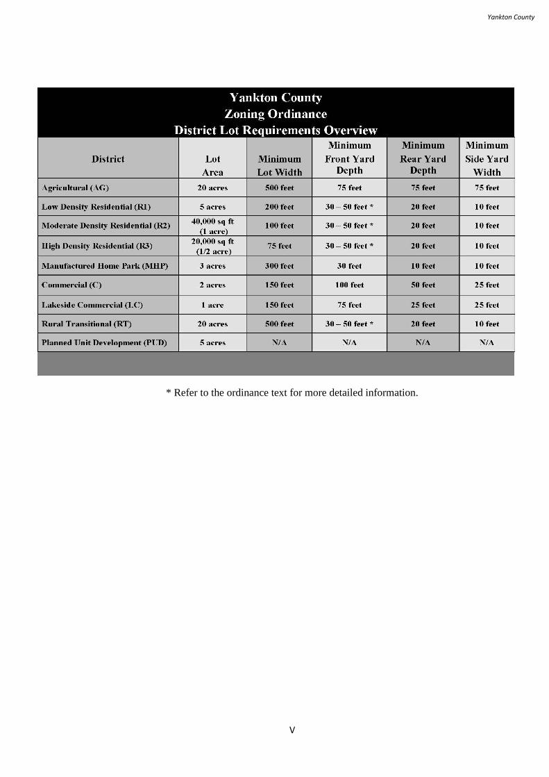
District Lot Requirements…………………………………………………………………………….Page V
Official Zoning Map – Main ............................................................................................................... Page VI
Official Zoning Map – Mission Hill South ......................................................................................... Page VII
Official Zoning Map – Utica South ..................................................................................................... Page VIII
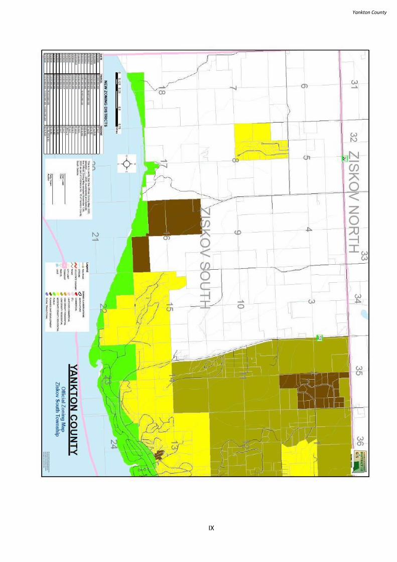
Official Zoning Map – Ziskov South .................................................................................................. Page IX
ZONING ORDINANCE
Definitions...............................................................................................................................Page 1
ARTICLE 1: Jurisdiction ..................................................................................................... Page 34
ARTICLE 2: Application of District Regulations. ................................................................ Page 36
ARTICLE 3: Establishment of Districts ............................................................................... Page 38
ARTICLE 4: Official Zoning Map and Boundary Interpretation. ........................................ Page 40
ARTICLE 5: Agriculture District (AG) ............................................................................... Page 43
ARTICLE 6: Low Density Rural Residential District (R1) ................................................. Page 55
ARTICLE 7: Moderate Density Rural Residential District (R2) ...................... ................... Page 60
ARTICLE 8: High Density Rural Residential District (R3).............................. ................... Page 64
ARTICLE 9: Manufactured Home Park District (MHP).................................. .................... Page 68
ARTICLE 10: Commercial District (C)........................................................... ..................... Page 75
ARTICLE 11: Lakeside Commercial District (LC).......................................... .................... Page 80
ARTICLE 12: Rural Transitional District (RT)................................................ .................... Page 85
ARTICLE 13: Planned Unit Development (PUD)............................................ .................... Page 91
ARTICLE 14: Sign Regulations............................................................................................ Page 94
ARTICLE 15: Supplementary District Regulations......................................... ..................... Page 102
ARTICLE 16: Nonconformance........................................................................ ................... Page 107
ARTICLE 17: Administrative Procedure and Enforcement.......................... ....................... Page 111
ARTICLE 18: Planning Commission............................................................ ....................... Page 118
ARTICLE 19: Board of Adjustment .................................................................................... Page 125
ARTICLE 20: County Commission ..................................................................................... Page 131
ARTICLE 21: Duties on Matters of Appeals ........................................................................ Page 135
ARTICLE 22: Amendments or Rezoning ............................................................................ Page 137
ARTICLE 23: Violations, Complaints, Penalties, and Remedies. ............. .......................... Page 140
ARTICLE 24: Legal Status Provisions.............................................. ................................... Page 143
ARTICLE 25: Siting of Wireless Telecommunication Facilities ......................................... Page 145

Yankton County
III
ARTICLE 26: Wind Energy Systems ................................................................................... Page 168
ARTICLE 27: Highway 52 Corridor Overlay District .......................................................... Page 180
ARTICLE 28: Subdivision Regulation ................................................................................. Page 190
Yankton County
IV
COUNTY OFFICIALS
Yankton County Commission:
Dan Klimisch, Yankton
Joseph Healy, Yankton
Cheri Loest, Utica
Don Kettering, Yankton
Gary Swensen, Yankton
Yankton County Planning Commission:
Donna Freng, Yankton
Greg Hansen, Mission Hill
Paul Harens, Yankton
Joseph Healy, Yankton
Doug Hevle, Yankton
Dan Klimisch, Yankton
Dennis Michael, Yankton
Kristi Schultz, Yankton
Zane Williams, Irene
Yankton County Zoning Administrator:
Gary Vetter, (605) 260-4445
Yankton County Deputy Zoning Administrator:
Jessica Atkinson, (605) 260-4447
Yankton County Auditor:
Patty Hojem, (605) 260-4436
Yankton County
V
* Refer to the ordinance text for more detailed information.
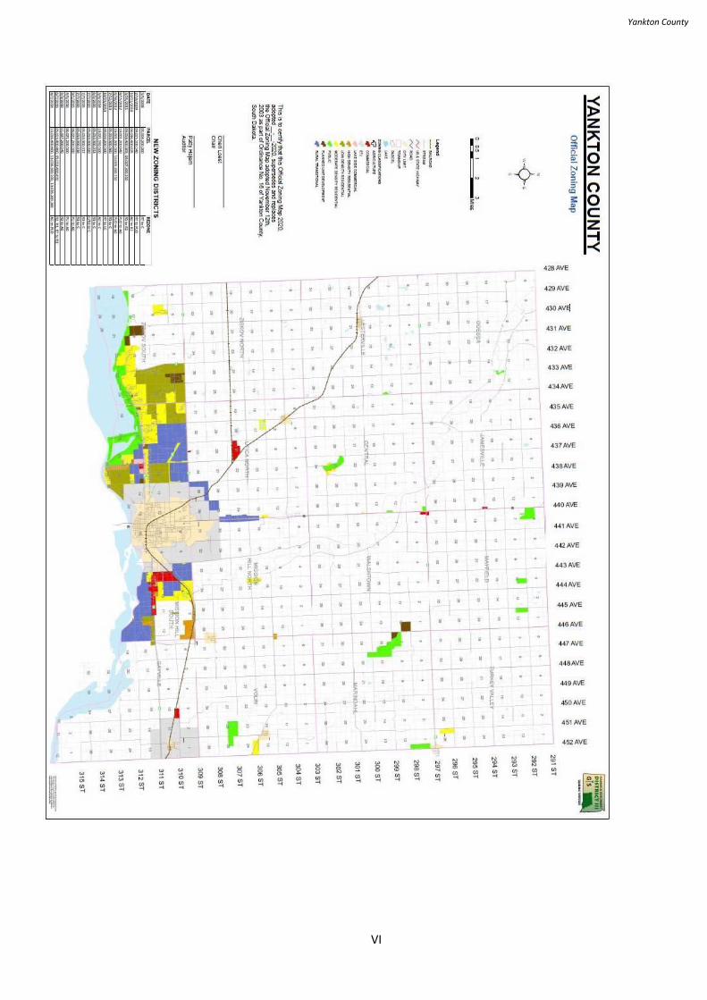
Yankton County
VI
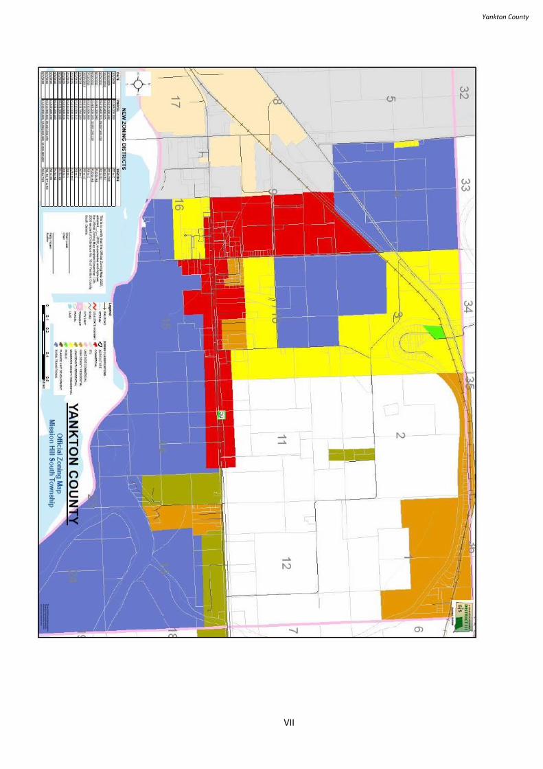
Yankton County
VII
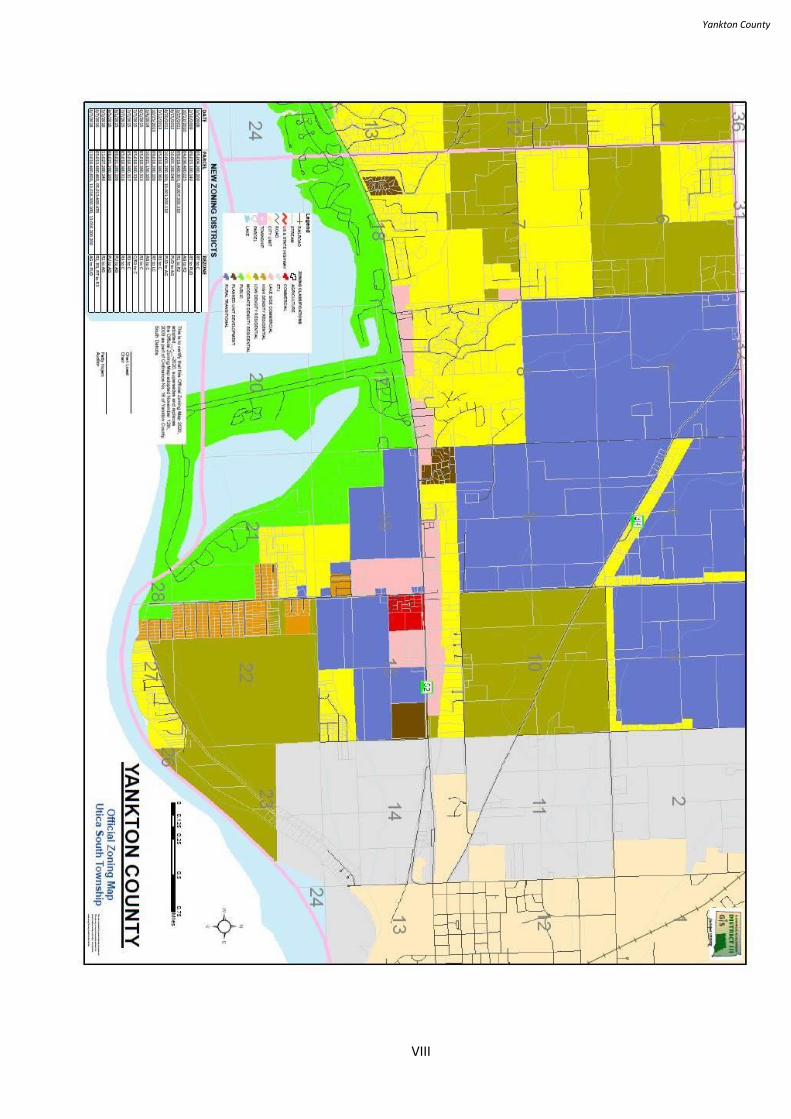
Yankton County
VIII
Yankton County
IX
Yankton County
1
DEFINITIONS
Definitions
For the purpose of this Ordinance, unless otherwise stated, words used in the present
tense include the future; the singular number includes the plural and the plural the
singular; the word shall means mandatory, not discretionary; the word may is
permissive; the word person includes a firm, association, organization, partnership,
trust, company or corporation, as well as, an individual; the word lot includes
the word plat or parcel; and the words used or occupied include the words intended,
designed, or arranged to be used or occupied.
Terms
For the purpose of this Ordinance, certain terms or words used herein shall be
interpreted as follows:
Abandoned Sign/Billboard - a sign or sign structure that is blank, obliterated or
displays obsolete advertising material for a period in excess of twelve continuous
months. The twelve-month period for determining if a sign is abandoned commences
upon notification of violation to the offender.
Abut - Having a common border with, or being separated from such a common border
by a right-of-way, alley, or easement.
Accessory Agricultural Structure - A structure customarily incidental and necessary to
farming and the raising of animals including barns and other animal shelters, corrals
and fences, silos and storage sheds for machinery and crops.
Accessory Building - A subordinate building, the use of which is purely incidental to
the main building. It shall be unlawful for any person, firm, or corporation in the
following Yankton County Zoning Districts: Low Density Rural Residential (R1),
Moderate Density Rural Residential (R2), High Density Rural Residential (R3),
Manufactured Home Park (MHP), Lakeside Commercial (LC), Rural Transitional
(RT), Planned Unit Development (PUD) to use any van body, truck body, semi-
trailer, rail car, “shipping crate”, and/or any vehicle no longer used for its
manufactured purpose as a storage shed, storage building, warehouse, or as living
quarters. It shall be unlawful to use manufactured homes for any use other than
residential living quarters in all Yankton County Zoning Districts. However, this shall
not prevent the lawful parking of vehicles properly licensed, insured, and in regular
use for their intended purpose to include ‘RVs’ and camping trailers. (Amended May
19, 2020)
Accessory Use or Structure - A use or structure on the same lot with and of a nature
customarily incidental and subordinate to the principal use or structure. It shall be
unlawful for any person, firm, or corporation in the following Yankton County
Zoning Districts: Low Density Rural Residential (R1), Moderate Density Rural
Residential (R2), High Density Rural Residential (R3), Manufactured Home Park
Yankton County
2
(MHP), Lakeside Commercial (LC), Rural Transitional (RT), Planned Unit
Development (PUD) to use any van body, truck body, semi-trailer, rail car, “shipping
crate”, and/or any vehicle no longer used for its manufactured purpose as a storage
shed, storage building, warehouse, or as living quarters. It shall be unlawful to use
manufactured homes for any use other than residential living quarters in all Yankton
County Zoning Districts. However, this shall not prevent the lawful parking of
vehicles properly licensed, insured, and in regular use for their intended purpose to
include ‘RVs’ and camping trailers.
Actual Construction - Actual construction is hereby defined to include the placing of
construction materials in permanent position and fastened in a permanent manner.
Where excavation or demolition or removal of an existing building has been
substantially commenced, preparatory to building, such excavation or demolition or
removal shall be deemed to be actual construction, provided that work shall be carried
on diligently.
Addition - Any construction that increases the size of a building such as a porch,
attached garage or carport, or a new room.
Administrative Review - A process brought forth by the Zoning Administrator to
clarify a provision of the Zoning Ordinance. A review may include policy
interpretation or procedural questions but shall not include the appeals process as
detailed herein.
Adult Entertainment - Any premises or part thereof in which a principal feature or
characteristic is the nudity or partial nudity of any person; to include a place or part
thereof where, in pursuance of a trade, calling, business or occupation, goods or
services appealing to or designed to appeal to erotic or sexual appetites or
inclinations.
Advertising Sign - An advertising sign, billboard, or poster panel which directs
attention to a business, commodity, service, or entertainment not exclusively related
to the premises where such advertising sign is located or to which it is affixed, but
does not include those business signs which direct attention to the business on the
premises to a brand name of a product or commodity with which the business is
specifically identified and which is sold on the premises.
Agriculture - The planting, cultivating, harvesting and storage of grains, hay or plants,
fruits, or vineyards along with the raising and feeding of livestock and/or poultry shall
be considered an agricultural use. Grain elevators or Agricultural Product Processing
Facilities shall not be considered an agricultural use if such use constitutes the main
or principal use on a lot or parcel.
Agriculture Product Processing Facility - A business activity customarily designed to
process raw agricultural products into value added products. Agricultural processing
facilities include, but are not limited to; feed mills, ethanol plants, soy bean
processing facilities, cheese plants, milk processors, packing plants and rendering
facilities.
Yankton County
3
Alley - A way which affords only a secondary means of access to abutting property.
Amendment - A change in the wording or substance of this ordinance or a change in
the boundaries or classifications upon the Official Zoning Map.
Amusement Park - A facility, primarily outdoors, that may include structures and
buildings, where there are various devices for entertainment including rides, booths
for the conduct of games or sale of items, buildings for shows and entertainment and
restaurants and souvenir sales.
Animal Feeding Operation: An animal feeding operation is a lot or facility where an
established number of animal units are confined, stabled, fed, or maintained in either
an open or housed lot for a total of 45 days or more in any 12-month period. The open
lot does not sustain crops, vegetation, forage growth, or post-harvest residues in the
normal growing season. Two or more facilities under common ownership are
a single animal operation if they adjoin each other (within one mile), or if they use a
common area or system for the disposal of manure.
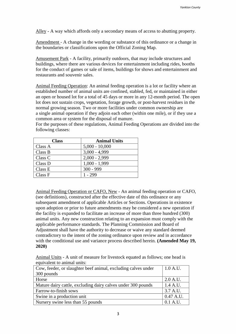
For the purposes of these regulations, Animal Feeding Operations are divided into the
following classes:
Class Animal Units
Class A 5,000 - 10,000
Class B 3,000 - 4,999
Class C 2,000 - 2,999
Class D 1,000 - 1,999
Class E 300 - 999
Class F 1 - 299
Animal Feeding Operation or CAFO, New - An animal feeding operation or CAFO,
(see definitions), constructed after the effective date of this ordinance or any
subsequent amendment of applicable Articles or Sections. Operations in existence
upon adoption or prior to future amendments may be considered a new operation if
the facility is expanded to facilitate an increase of more than three hundred (300)
animal units. Any new construction relating to an expansion must comply with the
applicable performance standards. The Planning Commission and Board of
Adjustment shall have the authority to decrease or waive any standard deemed
contradictory to the intent of the zoning ordinance upon review and in accordance
with the conditional use and variance process described herein. (Amended May 19,
2020)
Animal Units - A unit of measure for livestock equated as follows; one head is
equivalent to animal units:
Cow, feeder, or slaughter beef animal, excluding calves under
300 pounds
1.0 A.U.
Horse 2.0 A.U.
Mature dairy cattle, excluding dairy calves under 300 pounds 1.4 A.U.
Farrow-to-finish sows 3.7 A.U.
Swine in a production unit 0.47 A.U.
Nursery swine less than 55 pounds 0.1 A.U.
Yankton County
4
Finisher swine over 55 pounds 0.4 A.U.
Sheep or lambs 0.1 A.U.
Laying hens or broilers 0.033 A.U.
Ducks and/or geese 0.2 A.U.
Turkeys 0.018 A.U.
Animal Unit Conversion Table - A conversion table designed to integrate the
definition of animal feeding operations with the animal unit definition. (Amended
06/08/06)
Species Animal Class A Class B Class C Class D Class E
Cow, feeder or
slaughter beef
animal, excluding
calves under 300
pounds
10,000 -
5000
4,999 –
3,000
2,999 –
2,000
1,999 –
1,000
999 - 300
Horses 5,000 –
2,500
2,499 –
1500
1,499 –
1,000
999 –
500
499 - 150
Mature dairy
cattle, excluding
calves under 300
pounds
7,143 –
3,571
3,570 –
2,143
2,142 –
1,429
1,428 -
714
713 - 214
Farrow to finish
sows
2,703 –
1,351
1,350 -
811
810 –
541
540 -
270
269 – 81
Swine in a
production unit
21,276 –
10,638
10,637 –
6,382
6,381 -
4,255
4,254 –
2,128
2,127 - 638
Nursery swine
less than 55
pounds
100,000 –
50,000
49,999 –
30,000
29,999 –
20,000
19,999 –
10,000
9,999 –
3,000
Finisher swine
over 55 pounds
25,000 –
12,500
12,499 –
7,500
7,499-
5,000
4,999 –
2,500
2,499 –
750
Sheep 100,000 –
50,000
49,999 –
30,000
29,999 –
20,000
19,999 –
10,000
9,999 –
3,000
Laying hens 303,030 –
151,515
151,514
– 90,909
90,908 –
60,606
60,605 –
30,303
30,302 -
92090
Ducks and/or
geese
50,000 –
25,000
24,999 –
15,000
14,999 –
10,000
9,999 –
5,000
4,999 –
1,500
Turkeys 555,555 –
277,777
277,776
–
166,666
166,665
–
111,111
111,110
– 55,555
55,554 –
16,666
Animal Waste Facility - A structure designed and constructed to store and/or process
animal waste. Animal waste facilities include but are not limited to holding basins,
lagoons, pits and slurry stores.
Apartment - A portion of a multiple dwelling used as a separate housing unit and
having cooking facilities and a private bath.
Yankton County
5
Applicant - For purposes of this Ordinance a person shall be deemed to be an
applicant if they are the owner of the proposed facility; an officer or director of the
owner thereof; or an owner of any interest, direct or indirect, in any company, except
a publicly traded company, which is the owner of the proposed development.
Aquaculture - Land devoted to the hatching, raising and breeding of fish or other
aquatic plants or animals for sale or personal use.
Arcade - A place of business where an individual, association, partnership or
corporation maintains four or more amusement devices for public use.
Auction Barn - Any premises used predominantly as a livestock auction facility and
may include the auction of agriculturally related items on an incidental or accessory
basis only. The term may also include a building or structure or lands used for the
storage of goods and materials which are to be sold on the premises by public auction,
and for the sale of the said goods and materials by public auction and on an
occasional basis.
Auction Yard - Any premises used predominantly as an auction pavilion or any area
dedicated to consignment auctions or similar activities. A yard may include structures,
open, and fenced display areas.
Automobile-Machinery Service Station - Building and premises where motor fuel, oil,
grease, batteries, tires, and vehicle accessories may be supplied and dispensed at
retail, and where, in addition, customary repair services may be rendered.
Automobile Wrecking Yard - Any premises on which two or more self-propelled
vehicles not in running order or operating condition are stored in the open. See also
Junkyard and Salvage Yard.
Back-To–Back Sign: An off-site or on-site sign consisting of two sign facings
oriented in the opposite direction with not more than one face per side.
Bar - A building or part thereof where, in consideration of payment therefore, liquor,
beer, or wine or any combination thereof are served for consumption on the premises,
with or without food.
Basement - A portion of a building with the floor located below the mean grade level.
For the purpose of this ordinance, any such basement with more than four (4) feet
above grade level shall be counted as a story. No dwelling unit shall be situated in a
basement having less than four (4) feet above grade level.
Bed and Breakfast - A dwelling occupied by a family and used incidentally to provide
accommodation and meals to guests for remuneration, but shall not include a boarding
house, residential care facility, hotel, motel, or other similar uses.
Billboard - See Sign, Off-Site.
Board of Adjustment - The Yankton County Commission shall serve as the Board of
Adjustment.
Yankton County
6
Buildable Area - The portions of a lot remaining after required yards have been
provided.
Building - The word "building" includes the word structure and is a structure that is
entirely separate from any other structure by space or by walls in which there is no
communicating doors or windows or similar openings. A principal building including
covered porches and paved patios, is a building in which is conducted the principal
use of the lot on which it is situated. In any residential district, any dwelling shall be
deemed to be the principal building on the lot on which the same is situated.
Building Line, Front - A line parallel to the street, or right-of-way intersecting the
foremost point of the building, excluding uncovered steps.
Building Setback Lines - A line parallel or approximately parallel to the lot lines at a
specified distance therefrom, marking the minimum distance from the lot line that the
building may be erected.
Building Site - A lot or parcel, or portion thereof, whether a lot of record or described
by metes and bounds, used or intended to be used as the location of a building for
housing one or two families.
Building, Alterations of - Any change or rearrangement of the supporting members
(such as bearing walls, beams, columns, or girders) of a building, an addition to a
building, or movement of a building from one location to another. See Structural
Alterations.
Building, Height of - The vertical distance measured from the average grade of the
building level of the highest and lowest elevations of the site covered by the building
to the top of the roof or parapet of the highest story.
Building, Principal - A building in which is conducted the main use of the lot on
which said building is located.
Bus Depot - A building or premises where commercial motor vehicles pick up and
discharge fare-paying, passengers. Accessory uses may include ticket offices, luggage
checking facilities and similar uses.
Business Sign - A sign which directs attention to a business or profession conducted
or to a commodity, service, or entertainment sold or offered upon the premises on
which such sign is located or to which it is affixed. See also on-site and off-site signs.
Camper - See Travel Trailer.
Campground - Any premises where two (2) or more camping units are parked or
placed for camping purposes, or any premises used or set apart for supplying to the
public camping space for two (2) or more camping units for camping purposes, which
include any buildings, structures, vehicles or enclosures, uses or intended for use or
intended wholly, or in part, for the accommodation of transient campers.
Yankton County
7
Camping Unit - Any vehicle, tent, trailer or portable shelter used for camping
purposes.
Car Wash - An establishment having facilities for washing motor vehicles by
production line methods which may include a conveyor system or similar mechanical
devices. This definition may also include a self-service operation.
Casino - A room or rooms in which legal gaming is conducted.
Cellar - A portion of a building between two floor levels which is partly or wholly
underground and which has more than one-half (½) of its height, from finished floor
to finished ceiling or to the underside of the floor joists of the story next above, as the
case may be, below the average finished grade level adjacent the exterior walls of the
building.
Cemetery - Land that is set apart or used as a place for the interment of the dead or in
which human bodies have been buried. “Cemetery” may include a structure for the
purpose of the cremation of human remains and may include facilities for storing
ashes of human remains that have been cremated or the interment of the dead in
sealed crypts or compartments.
Church - A building wherein persons regularly assemble for religious worship, and
which is maintained and controlled by a religious body organized to sustain public
worship.
Clinic - A building or part of a building used solely for the purpose of consultation,
diagnosis and treatment of patients by one or more legally qualified physicians,
dentists, optometrists, podiatrists, chiropractors, or drugless practitioners, together
with their qualified assistants, and without limiting the generality of the foregoing, the
building may include administrative offices, waiting rooms, treatment rooms,
laboratories, pharmacies and dispensaries directly associate with the clinic, but shall
not include accommodation for in-patient care or operating rooms for major surgery.
Club - A building owned, leased, or hired by a non-profit association of persons the
use of which is generally restricted to due-paying members and their guests. Such
club may periodically be rented, or leased, to non-members for gathering such as
weddings, anniversaries, and dances, but no portion of the building shall continuously
be used for business purposes.
Company - For purposes of this ordinance the term, “company” includes, but is not
limited to, any corporation, partnership, limited liability company, limited liability
partnership, limited partnership, business trust and any other business entity.
Comprehensive Plan - Any legally adopted part or element of the Yankton County
Comprehensive Plan.
Concentrated Animal Feeding Operation: An animal feeding operation that holds
more than 1,000 animal units and smaller operations that discharge pollutants that
impair a stream or other surface water are Concentrated Animal Feeding Operations
(CAFOs).
Yankton County
8
Conditional Use - A conditional use is a use that would not be appropriate, generally
or without restriction, throughout the zoning district, but which, if controlled as to
number, area, location or relation to the neighborhood, would promote the public
health, safety, welfare, morals, order, convenience, appearance, prosperity or general
welfare. Such uses may be permitted in such zoning district as conditional uses, if
specific provision for such conditional use is made in this Ordinance.
Congregate Housing - Housing units that provide a semi-independent living
environment, which offers residential accommodations, central dining facilities
(where at least one (1) meal a day is provided seven (7) days a week), related
facilities, and supporting staff and services to persons of at least sixty-two (62) years
of age or with disabilities.
Construction Services - A yard, structure, or combination thereof of any general
contractor or builder where equipment and materials are stored or where a contractor
performs shop or assembly work but does not include any other yard or establishment
otherwise defined or classified herein.
Contiguous - Next to, abutting, or touching and having a boundary, or portion thereof,
which is adjoining.
Contractor - The person who contracts with an individual or developer to construct a
building on a parcel of land prepared by a developer.
Convenience Store - A retail store in which articles for sale are restricted to gasoline
sales and a limited range of food items such as milk, bread, soft drinks, ice cream,
canned and bottled goods, snacks and candy. Retail sales may also include the limited
sale of magazines, books, house wares, toiletries, bait, alcoholic beverages and
tobacco.
Court - Any open space, unobstructed from ground to sky, other than a yard, that is on
the same lot with and bounded on two or more sides by the walls of a building.
Covenant - An agreement, convention, or promise of two or more parties, by deed in
writing, signed and delivered, by which either of the parties pledges himself to the
other that something is either done, or shall be done, or shall not be done. The term is
currently used primarily with respect to promises in conveyance or other instruments
relating to real estate.
Cul-de-sac - A local right-of-way with only one outlet that terminates in a vehicular
turnaround and having an appropriate terminal for the safe and convenient reversal of
traffic turnaround.
Day Care - The providing of care and supervision of children or adults as a
supplement to regular parental or home care, without transfer of legal custody or
placement for adoption, with or without compensation, on a regular basis for a part of
a day.
Day Care Center - Any type of group day care programs including nurseries for
children of working parents, nursery schools for children under minimum age for
education in public schools, parent cooperative nursery schools, playgroups for pre-
Yankton County
9
school children, programs covering after-school care for school children provided
such establishment is licensed by the State and conducted in accordance with State
requirements.
Day Care, Family - The provision of regular care and supervision of no more than
twelve (12) children including the provider’s own children who are under the age of
six (6) years for part of a twenty-four (24) hour period as a supplement to regular
parental care.
Day Care, Group Family Home - The provision of regular care and supervision of
thirteen (13) to twenty (20) children either in the provider’s home or in a facility
outside the provider’s home for part of a twenty-four (24) hour period as a
supplement to regular parental care.
Deck - A structure abutting a dwelling with no roof or walls except for visual
partitions and railings that is constructed on piers or a foundation above-grade for use
as an outdoor living area.
Developer - The owner of the property being platted or replatted or the person
designated by the owner as being responsible for the development of the property.
The terms “subdivider” and “developer” are synonymous and used interchangeably,
and shall include any person, partnership, firm, association, corporation and/or any
officer, agent, employee and trustee thereof who does or participates in the doing of
any act toward the subdivision of land within the intent, scope and purview of this
Ordinance. The developer shall also be defined as the builder or contractor if they are
responsible for the construction of buildings and/or structures or permanent
improvements.
Directional Sign - A sign erected for the convenience of the public, such as directing
traffic movement, parking or identifying restrooms, public telephones, walkways and
other similar features or facilities and bearing no advertising in the message.
Domesticated Large Animals - Any animal that through long association with man,
has been bred to a degree which has resulted in genetic changes affecting the
temperament, color, conformation or other attributes of the species to an extent that
makes it unique and different from wild individuals of its kind. For the purpose of this
ordinance the definition shall include, but is not limited to, animals commonly raised
on farms and ranches, such as cattle, horses, hogs, sheep, and mules.
Dormitory - A building or part of a building operated by an institution and containing
a room or rooms forming one or more habitable units which are used or intended to be
used by residents of the institution for living and sleeping, but not for cooking or
eating purposes.
Double Faced Sign - An off-site or on-site sign with two adjacent faces oriented in the
same direction and not more than 10-feet apart at the nearest point between the two
faces.
Drive-in Restaurant or Refreshment Stand - Any place or premises used for sale,
dispensing, or serving of food, refreshments, or beverages in automobiles, including
Yankton County
10
those establishments where customers may serve themselves and may eat or drink the
food, refreshments, or beverages on the premises.
Due Diligence - Such a measure of prudence, activity, or assiduity, as is properly to
be expected from, and ordinarily exercised by, a reasonable and prudent man under
the particular circumstances; not measured by any absolute standard, but depending
on the relevant facts of the special case.
Dwelling - A building or portion of a building designed for residential purposes,
including one and two family dwellings, but not including hotels, motels or lodging
houses.
Dwelling Unit - A room or suite of rooms designed for and occupied by one family
and having not more than one kitchen facility.
Dwelling, Efficiency Unit - A dwelling unit having only one room exclusive of
bathroom, kitchen, laundry, pantry, foyer, communicating corridor, closets, or any
dining alcove. An efficiency unit shall be permitted in a multi-family dwelling.
Dwelling, Multiple Family - A residential building designed for, or occupied by, three
(3) or more families, with the number of families in residence not exceeding the
number of dwelling units provided.
Dwelling, Single Family - A detached residential dwelling unit other than a
manufactured home designed for or occupied by one (1) family only.
Dwelling, Two Family - A building containing two dwelling units designed
exclusively for occupancy by two families living independently of each other.
Easement - Authorization by a property owner for the use by another, and for a
specified purpose, of any designated part of their property. For the purposes of this
Ordinance the term shall primarily be used to describe utility access.
Employee(s) - In regard to off right-of-way parking requirements, all who work in the
enterprise, including owners.
Exhibition Areas - A building, group of buildings, or place where art, objects, articles,
or livestock or agricultural projects are placed on display for the public.
Extraterritorial Zoning Jurisdiction - The area illustrated within the Official Zoning
Map of Yankton County not exceeding one (1) mile in width immediately adjoining
the City of Yankton.
Facility - A building, piece of land or any combination thereof owned and operated by
the same owner and dedicated to a specific use or uses. The term shall include those
operations where indoor and outdoor activities may be conducted in concert and are
integral or compliment the operation as a whole. An example may be an automobile
dealership with office spaces, a small indoor display area, separate maintenance
facility, and an outdoor display area.
Yankton County
11
Fairground - An agricultural fairground where farm produce is on display for judging
and for sale, and livestock shows, horseracing and other sports events are held and on
occasion for auctions, flea markets and concession stands.
Family - Any number of individuals living together as a single housekeeping unit, in
which not more than five (5) individuals are unrelated by blood, marriage or adoption.
This definition shall not include foster families as regulated by the State.
Farm Building - All buildings and structures needed in agricultural operation,
including dwellings for owners, operators, farm laborers employed on the farm, and
other family members.
Farm Drainage Systems - The term shall include all waterways, ditches, flood control,
watershed, and erosion control structures and devices provided each individual system
or structure comply with the applicable local, state, and federal regulations.
Farm Occupation - A business activity customarily carried out on a farm by a member
of the occupant's family without structural alterations in the building or any of its
rooms, without the installation or outside storage of any machinery, equipment or
material other than that customary to normal farm operations, without the
employment of more than two (2) persons not residing in the home, which does not
cause the generation of additional traffic in the area. Farm occupations include, but
are not limited to, seed sales and custom combining support facilities.
Farm Unit - All buildings and structures needed in an agricultural operation, including
dwellings for owners, operators, and other family members.
Farm, Hobby - An activity carried out in rural residential areas, which includes the
planting, cultivating, harvesting and storage of grains, hay or plants, fruits, or
vineyards. The raising and feeding of livestock and poultry shall be considered as part
of a hobby farm if the area, in which the livestock or poultry is kept, is one (1) acre or
more in area for every one (1) animal unit, and if such livestock does not exceed ten
(10) animal units.
Farm, Ranch, Orchard - An area of not less than twenty (20) acres of unplatted land,
or is a part of a contiguous ownership of not less than eighty (80) acres of unplatted
land, which is used for growing usual farm products, vegetables, fruits, trees, and
grain, and for the raising thereon of the usual farm poultry and farm animals such as
horses, cattle, hogs and sheep, and including the necessary accessory uses for raising,
treating, and storing products raised on the premises; but excluding an Animal
Feeding Operation. The processing and storage of raw agricultural products, such as
grain elevators and ethanol plants, shall not be considered a farm, ranch or orchard if
such constitutes the main or principal use on the lot or parcel.
Farmstead - A place with empirical evidence of a previous farmstead including at a
minimum foundations, structures, or a tree belt. For the purposes of this ordinance the
Zoning Administrator or Planning Commission shall determine the eligibility of a
farmstead as a building site as described within Section 513(3).
Yankton County
12
Fence - An artificially constructed barrier of any material or combination of materials
erected to enclose, screen, or separate areas.
Financial Institutions - The premises of a bank, trust, finance, mortgage, or
investment company.
Fireworks, Sales - A building, structure, or place where fireworks are sold, pursuant
to all applicable state statutes.
Fishery - As defined by South Dakota Administrative Rules, Sections 74:51:02:02 and
74:51:02:03 (January 17, 1999). Yankton County as described in Section 74:51:02:68.
Lakes Marindahl and Yankton (Section 74:51:02:03(4)) are warm water
permanent fish life propagation waters;
State or Beaver Lake and Westside Kid’s Pond (Section 74:51:02:03(6)) are
warm water marginal fish life propagation waters.
The Missouri River (Section 74:51:03:05(1,4,7,8,11)) is a domestic water
supply, warm water permanent fish life propagation waters, immersion
recreation waters, limited contact recreation waters, and commerce and
industry waters.
James River (Section 74:51:03:20(5,8)) is a warm water semi permanent fish
life propagation waters and limited contact recreation waters;
Beaver Creek, Mud Creek (Section 74:51:03:20(6, 8)), Clay Creek, and
Turkey Creek (Section 74:51:03:25(6, 8)) are warm water marginal fish life
propagation waters and limited contact recreation waters.
Flammable or Combustible Liquids, or Hazardous Material - Flammable material is any
material that will readily ignite from common sources of heat, or that will ignite at a
temperature of 600o F or less. Flammable liquid is any liquid having a flash point below 100oF
and having vapor pressure not exceeding forty (40) pounds per square inch (absolute) at
100oF. Combustible liquid is any liquid having a flash point at or above 100oF. Hazardous
material includes any flammable solids, corrosive liquids, radioactive materials, oxidizing
materials, highly toxic materials, poisonous gases, reactive materials, unstable materials,
hyperbolic materials, pyrophoric materials, and any substance or mixture of substances which
is an irritant, a strong sensitizer or which generates pressure through exposure to heat,
decomposition or other means.
Flood or Flooding - A general and temporary condition of partial or complete
inundation of normally dry land areas from:
1. The overflow of wetlands, lakes, streams, tributaries, or other water bodies; and/or
2. The unusual and rapid accumulation or runoff of surface waters from any source.
Flood Hazard Boundary Map (FHBM) - The official map issued by the Federal
Insurance Administration where the areas of special flood hazard have been
designated Zone A.
Floodway - The channel of a river or other watercourse and the adjacent land areas
that must be reserved in order to discharge the base flood without an accumulative
increase in the water surface.
Yankton County
13
Food Product Processing Facility - A commercial establishment in which food or
food-related products are processed, packaged, or otherwise prepared for human
consumption but not consumed on the premises.
Footprint – The land area covered or occupied by a building and a facility as defined
herein. The term shall also include any land area dedicated to a use such as outdoor
storage or any area utilized for storage, display, or livestock confinement as part of or
in support of the building or use.
Game Farm - An area of five (5) acres or more, which is used for producing hatchery,
raised game and non-domestic animals for sale to private shooting preserves.
Game Lodge - A building or group of detached, or semi-detached, or attached
buildings occupied or used as a temporary abiding place of sportsmen, hunters and
fishermen, who are lodged, with or without meals, and in which there are more than
two (2) sleeping rooms.
Gaming Device or Gaming Equipment - Any mechanical contrivance or machine used
in connection with gaming or any game.
Gaming or Gambling - The dealing, operating, carrying on, conducting, maintaining,
or exposing for pay of any game.
Gaming or Gambling Establishment - Any premises wherein or whereon gaming is
done.
Garage - An accessory building or portion of a building including a carport which is
designed or used for the sheltering of private motor vehicles and the storage of
household equipment incidental to the residential occupancy and in which there are
no facilities for repairing or servicing of such vehicles for remuneration or
commercial use.
Garage, Public - A building or portion thereof used for the housing or care of motor
vehicles for the general public or where such vehicles are equipped or repaired for
remuneration or kept for hire or sale. This may include premises commonly known as
“gasoline stations” or “service stations”.
Gasoline Station - Any area of land, including structures thereon, that is used for the
sale of gasoline or other motor vehicle fuel, and oil or other lubrication substances;
and which may include facilities used or designed to be used for polishing, greasing,
washing, spraying, dry cleaning, or otherwise cleaning such vehicles.
Golf Course - A public or private area operated for the purpose of playing golf, and
includes a par 3 golf course, club house and recreational facilities, driving ranges, and
miniature golf courses, and similar uses.
Grain Elevator - Grain storage facilities, which are the principal and primary use of
the lot. Said facilities are generally equipped with devices for housing and discharging
significant quantities of grain. This definition does not include normal farm product
storage and warehousing facilities such as grain bins and where such storage is an
accessory use to the parcel.
Yankton County
14
Grandfather - For the purposes of this ordinance the term “grandfather” shall be
defined as a lay term used to describe structures, land uses, facilities, operations or
similar activities in existence prior to adoption of the zoning ordinance. The term is
generally applied to uses not allowed or further regulated within the new ordinance.
The act or condition of grandfathered is more fully addressed in the nonconforming
Article herein.
Greenhouse, Commercial - A building for the growing of flowers, plants, shrubs,
trees, and similar vegetation which are not necessarily transplanted outdoors on the
same lot containing such greenhouse, but are sold directly from such lot at wholesale
or retail.
Group Home - See Residential Care Facility.
Highway - Every way or place of whatever nature open to the public, as a matter of
right, for purposed of vehicular travel, is a highway. The term “highway” shall also
include private access easements and roadways.
Home Occupation - A business activity customarily carried on in the home by a
member of the occupant's family without structural alterations in the building or any
of its rooms, without the installation or outside storage of any machinery, equipment
or material other than that customary to normal household operations, without the
employment of more than two (2) persons not residing in the home, which does not
cause the generation of traffic in excess of that experienced on an average right-of-
way of similar design, noise, electrical interference, fumes, odors, etc.
Horticulture - The science or art of cultivating fruits, vegetables, flowers, and plants.
Horticulture Sales - The on-site retail sale of farm produce, floral, fauna, or similar
items. The majority of the produce sold shall be seasonal in nature and grown on-site.
An exception may be a cooperative venture between numerous producers.
Hospital - An institution devoted primarily to the operation of facilities of the
diagnosis, treatment, and cure of disease, illness, injury, or other abnormal physical
conditions with provisions for keeping patients overnight.
Hotel - An establishment of transient guests having sleeping rooms without individual
cooking facilities for more than six (6) persons for compensation and may or may not
provide meals.
Interchange - A grade-separated intersection with one (1) or more direct connections
for vehicular travel between the intersecting right-of-ways.
Irrigation Systems - This term shall include all canals, ditches, piping, center pivot,
and other methods utilized to irrigate cropland. This term does not include systems
designed to land apply waste or water from animal feeding operations as defined
herein. All irrigation systems shall comply with local, state, and federal regulations.
Yankton County
15
Junkyard - A place where non-recyclable waste, having no economic values, or waste,
which is recyclable, but has no chance of being recycled is deposited.
Kennel - Any place where more than twenty (20) dogs, cats, or other domesticated
animals of breeding age are housed, groomed, bred, boarded, trained, harbored, kept,
or sold for commercial purposes.
Lagoon - Any pond, basin, or other impoundment made by excavation or earthen fill
for storage or treatment of human sewage or animal waste.
Landing Strip - A strip of ground used or capable of being used for the landing and
take-off of aircraft.
Loading Area - A completely off right-of-way, space, or berth on the same lot for the
loading or unloading of freight carriers, having adequate ingress and egress to a
public right-of-way.
Loading Space, Off Right-of-Way - Space logically and conveniently located for bulk
pickups and deliveries, scaled to delivery vehicles expected to be used, and accessible
to such vehicles when required off right-of-way loading space is not to be used as off
right-of-way parking space in computation of required off right-of-way parking space.
Locker - A meat processing plant and any other facility where meat, poultry or eggs
are cooked, cured, smoked, or otherwise processed or packed, provided that all
activities are carried out indoors. This term shall not include a delicatessen, stockyard,
slaughterhouse, tannery, a poultry killing establishment, an animal food factory, or an
animal by-products plant.
Lot - For purposes of this ordinance, a lot is a parcel of land of at least sufficient size
to meet minimum zoning requirements for use, coverage, and area, and to provide
such yards and other open spaces as are herein required. Such lot shall have frontage
on an improved public right-of-way, or on an approved private right-of-way, and may
consist of a single lot of record; a portion of a lot of record; a combination of
complete lots of record, of complete lots of record and portions of lots of record, a
parcel of land described by metes and bounds; provided that in no case of division or
combination shall any residual lot or parcel be created which does not meet the
requirements of this ordinance.
Lot Coverage - The percent of the area of a lot occupied by buildings, or structures,
including accessory building or structures.
Lot Depth - The average horizontal distance between the front and rear lot lines.
Lot Frontage - The portion of the lot nearest the right-of-way; for the purpose of
determining yard requirements on corner lots and through lots, all sides of a lot
adjacent to right-of-ways shall be considered frontage, and yards shall be provided as
indicated under “Yards” in this ordinance.
Lot Frontage, Pie Shaped - A lot usually abutting a cul-de-sac. For the purpose of
determining frontage, said distance shall be measured perpendicularly to the said lot
lines at a point thirty (30) feet from the front line.
Yankton County
16
Lot Line - The legally defined limits of any lot.
Lot, Corner - A lot situated at the intersection of two (2) right-of-ways, the interior
angle of such intersection not exceeding one hundred thirty five (135) degrees.
Lot, Double Frontage - A lot having frontage on two (2) non-intersecting right-of-
ways, as distinguished from a corner lot.
Lot Line, Exterior - The side lot line, which abuts the right-of-way on a corner lot.
Lot Line, Rear - The lot line or point of intersection of the side lot lines farthest from
and opposite the front lot line.
Lot Line, Side - A lot line other than a front or rear lot line.
Lot of Record - A lot which is part of a subdivision recorded in the office of the
County Register of Deeds, or a lot or parcel described by metes and bounds, the
description of which has been so recorded. For the purposes of this Ordinance, a
legally transacted parcel prior to adoption may be considered as a lot of record.
Lot Width - The mean horizontal distance between the side lot lines of a lot measured
at right angles to the depth or the same distance measured at the front building line.
Lot, Corner - A corner lot is defined as a lot located at the intersection of two (2) or
more right-of-ways. A lot abutting on a curved right-of-way(s) shall be considered a
corner lot if straight lines drawn from the foremost points of the side lot lines to the
foremost point of the lot meet at an interior angle of less than one hundred thirty-five
(l35) degrees.
Lot, Interior - An interior lot is defined as a lot other than a corner lot with only one
frontage on a right-of-way.
Lot, Through - A through lot is defined as a lot other than a corner lot with frontage
on more than one right-of-way. Through lots abutting two right-of-ways may be
referred to as double frontage lot.
Lot, Reversed Frontage - A reversed frontage lot is defined as a lot on which the
frontage is at right angles or approximately right angles, interior angle less than one
hundred thirty-five (135) degrees, to the general pattern in the area. A reversed
frontage lot may also be a corner or a through lot.
Major Road Plan - The Transportation Plan in the Yankton County Comprehensive
Plan.
Major Recreational Equipment - Major recreational equipment is defined as including
boats and boat trailers, travel trailers, pick-up campers or coaches, designed to be
mounted on automotive vehicles, motorized dwellings, tent trailers, and the like, and
case or boxes used for transporting recreational equipment, whether occupied by such
equipment or not.
Yankton County
17
Manufactured Home - A moveable or portable dwelling which is eight (8) feet or
more in width and thirty-two (32) feet or more in length, constructed on a chassis, and
which is designed to be towed, designed for year-round occupancy, primarily to be
used without a permanent foundation, but which may sit on a permanent foundation,
and designed to be connected to utilities. It may consist of one or more units,
separately transportable, but designed to be joined together into one integral unit.
Manufactured homes are built according to the Federal Manufactured Housing
Construction and Safety Standards Act of 1974, which became effective June 15,
1976. Manufactured homes are not mobile homes.
The following shall not be included in this definition:
1. Travel trailers, pickup coaches, motor homes, camping trailers, or other
recreational vehicles.
2. Manufactured modular housing which is designed to be set on a permanent
foundation, and which uses standard sheathing, roofing, siding, and electrical,
plumbing, and heating systems.
Manufactured Home Park - A parcel of land under single ownership, which has been
planned and improved for the placement of, manufactured homes for non-transient
use.
Manufacturing - The use of land, buildings or structures for the purpose of
manufacturing, assembly, making, preparing, inspecting, finishing, treating, altering,
repairing, warehousing or storing or adapting for sale of any goods, substance, article,
thing or service.
Manufacturing Light - The use of land, buildings or structures for the purpose of
manufacturing, assembly, making, preparing, inspecting, finishing, treating, altering,
repairing, warehousing or storing or adapting for sale of any goods, substance, article,
thing or service. Light manufacturing shall have no more than ten employees.
Massage Establishment - Any premises or part thereof where massages are given,
offered or solicited in pursuance of a trade or calling, business or occupation provided
that the service is rendered by a person duly trained, licensed and registered under the
appropriate statute.
Mobile Home - A transportable, factory-built home, designed to be used as a year-
round residential dwelling and built prior to the enactment of the Federal
Manufactured Housing Construction and Safety Standards Act of 1974, which
became effective June 15, 1976.
Modular Home - A structure or building module that is manufactured at a location
other than the site upon which it is installed and used as a residence; transportable in
one or more sections on a temporary chassis or other conveyance device; and to be
used as a permanent dwelling when installed and placed upon a permanent foundation
system. This term includes the plumbing, heating, air conditioning, and electrical
systems contained within the structure.
Motel - A group of attached or detached buildings on the same lot containing sleeping
quarters for rental to transients.
Yankton County
18
Motor Vehicle Track or Play Area - An area of land utilized for the racing or
recreational riding of motor vehicles with or without a defined area or track. The term
may include a racetrack with spectators and an established racing affiliation or a day
use area utilized by a club, group, or independent individuals. A motor vehicle may
include cars, trucks, motorcycles, all-terrain vehicles or similar items. (Amended
May 19, 2020)
Museum - A building or buildings used, or to be used, for the preservation of a
collection of paintings and/or other works of art, and/or of objects of natural history,
and/or of mechanical, scientific and/or philosophical inventions, instruments, models
and/or designs and dedicated or to be dedicated to the recreation of the public,
together with any libraries, reading rooms, laboratories and/or other offices and
premises used or to be used in connection therewith.
Navigable Waters - A body of water presently being used or is suitable for use for
transportation and commerce, or if it has been so used or was suitable for such use in
the past, or if it could be made suitable for such use in the future by reasonable
improvements.
Nonconforming Lot - A lot of record existing on the date of passage of this ordinance
which does not have the minimum width or contain the minimum area for the zone in
which it is located.
Nonconforming Structure - A lawful structure which exists on the date of passage of
this ordinance that could not be built under the terms of this ordinance by reason of
restrictions on area, lot coverage, height, yard setbacks, or other characteristics of the
structure.
Nonconforming Use - A land use or building or structure or portion thereof lawfully
existing at the effective date of this ordinance or at the time of any amendment
thereto, which does not conform to the regulations of the zone in which it is located.
Noxious - When used with reference to any use or activity in respect of any land,
building or structure or a use or activity which, from its nature or from the manner of
carrying on same, creates or is liable to create, by reason or destructive gas or fumes,
dust, objectionable odor, noise or vibration or unsightly storage of goods, wares,
merchandise, salvage, machinery parts, junk, waste or other material, a condition
which may become hazardous or injurious as regards to health or safety or which
prejudices the character of the surrounding area or interferes with or may interfere
with the normal enjoyment of any use of activity in respect of any land, building or
structure.
Nuisance - Any condition existing that is or may become injurious or dangerous to
health or that prevents or hinders or may prevent or hinder in any manner the
suppression of a disease.
Nursery - A facility confining a specific number of small and/or young swine
averaging ten (10) to fifty five (55) pounds in size.
Yankton County
19
Nursing Home, Rest Home, Convalescent Home - A place which undertakes through
its ownership or management to provide maintenance, personal, or nursing care for
three or more persons who by reason of illness, physical deformity, or old age are
unable to care for themselves.
Obstruction - Any structure or vegetation that blocks the complete vision of people.
Off-Site Sign - A sign/billboard that advertises goods or services not available at the
location of the billboard or advertising sign.
Office - A building or part thereof, designed, intended or used for the practice of a
profession, the carrying on of a business, the conduct of public administration, or,
where not conducted on the site thereof, the administration of an industry, but shall
not include a retail commercial use, any industrial use, clinic, financial institution or
place of amusement or place of assembly.
On-Site Sign - A sign identifying an establishment's activities, products or services
conducted or available on the property upon which it is located and signs advertising
the sale or lease of the property upon which they are located.
Open Sales Area - Any open land or area used or occupied for the purpose of
displaying for sale new or secondhand merchandise, including but not limited to,
passenger cars or trucks, farm machinery, construction machinery, motor scooters or
motorcycles, boats, trailers, aircraft, and monuments.
Outdoor Storage Area - Any open land or area used for the purpose of storage of any
product or part of a product either before, during, or after manufacturing, servicing, or
repairing and not displayed for retail sale. This does not include open sales areas.
Owner - The record owners of the fee or a vendee in possession, including any
person, group of persons, firm or firms, corporation or corporations, or any other legal
entity having legal title to or sufficient proprietary interest in the land sought to be
subdivided.
Ownership Line - A line defining ownership of property under one owner of record.
Parcel - A legally defined piece of property including a platted lot, legally described
portion, or similarly described piece of property primarily used as an identifier within
taxation.
Park - An area consisting largely of open space, which may include a recreational
area, playground, or similar use but shall not include a mobile home park, a
campground or trailer park.
Parking Space - An off right-of-way space available for parking of a motor vehicle
and which is held to be an area for dimension of which are ten (10) feet by twenty
(20) feet or which covers two hundred (200) square feet, exclusive of passageways
and driveways appurtenant thereto and giving access thereto. Off right-of-way
parking shall be on or adjacent to the property on which the principal use is located.
Yankton County
20
Parking Space, Off Right-of-Way - For the purposes of this ordinance, an off right-of-
way parking space shall consist of a space adequate for parking an automobile with
room for opening doors on both sides, together with properly related access to a right-
of-way and maneuvering room. Required off right-of-way parking areas for three (3)
or more automobiles shall have individual spaces marked, and shall be so designed,
maintained, and regulated that no parking or maneuvering incidental to parking shall
be on any right-of-way, and so that any automobile may be parked and un-parked
without moving another. For purposes of rough computation, an off right-of-way
parking space and necessary access and maneuvering may be estimated at three
hundred (300) square feet, but off right-of-way parking requirements will be
considered to be met only when actual spaces meeting the requirements above are
provided and maintained, improved in a manner appropriate to the circumstances of
the case, and in accordance with all ordinances and regulations of the County.
Pawnshop - An establishment where money is loaned on the security of personal
property pledged in the keeping of the pawnbroker.
Performance Standards –
Criterion established for the purposes of:
1. Assigning proposed land uses to proper districts; and
2. Controlling noise, odor, glare, smoke, toxic matter, aesthetics, vibration,
fire/explosive hazards generated by, or inherent in, uses of land or buildings.
Permitted Use - A use by right, which is specifically authorized in a particular zoning
district.
Person - Any individual or group of individuals, or any corporation, general or limited
partnership, joint venture, unincorporated association, or governmental or quasi-
governmental entity.
Places of Assembly - Places where people gather or congregate for amusement,
worship, learning, etc. This includes schools, churches, theaters, playgrounds, etc.
Plat - a map, or representation on paper, of a piece of land subdivided into lots, parcels,
tracts or blocks, including roads, commons, and public grounds, if any, all drawn to scale
and complete with all irrevocable offers of dedication.
Planning Commission - The Planning Commission of Yankton County. The term
Planning Commission shall be synonymous with Planning and Zoning Commission
and Commission, but shall not include Board of Adjustment or Zoning Board.
Planning Official: The Planning (Zoning) Administrator and his/her designee charged
with the administration and enforcement of the Yankton County Zoning Ordinance.
Plaza - A public square or similar open area.
Portable Processing Plant - Any equipment for the crushing, screening or washing of
sand and gravel aggregate materials, but not including a concrete batching plant or an
asphalt plant, which equipment is capable of being readily drawn or readily propelled
Yankton County
21
by a motor vehicle and which equipment is not considered permanently affixed to the
site.
Principal Use - The main use of land or structures as distinguished from a secondary
or accessory use.
Private Recreation Area - Any open space or recreational area, other than a public
park, owned and operated or maintained in whole or in part for profit by a private
individual(s), club or fraternal organization for members only, and may include
therein one or more of the following activities: swimming, boat facilities, picnic area,
tennis courts, outdoor skating rinks, athletic fields, walking, riding and cross-country
skiing, snowmobiling, but does not include the racing of animals, motor vehicles,
motorcycles or snowmobiles.
Private Shooting Preserves - An acreage of at least one hundred and sixty (160) acres
and not exceeding one thousand two hundred and eighty (1,280) acres either privately
owned or leased on which hatchery raised game and/or larger game is released for the
purpose of hunting, for a fee, over an extended season.
Property Line - The division between two parcels of land, or between a parcel of land
and the right-of-way.
Public - Promotion of a public cause or service, including utilities having a franchise
from Yankton County or other governmental entity, but excluding other for-profit
organizations.
Public Building - Any building which is owned, leased, primarily used, and/or
primarily occupied by a school district or municipal, county, state, or federal
government, or any subdivision or agency of the school district, municipal, county,
state, or federal government.
Publicly Traded Company - For purposes of this Ordinance a “publicly traded
company” means a company, the shares or other interests in which are regularly
traded on the New York Stock Exchange, the American Stock Exchange, NASDAQ
or similar recognized security market.
Quarry - A place where consolidated rock has been or is being removed by means of
an open excavation to supply material for construction, industrial, or manufacturing
purposes, but does not include a wayside quarry or open pit metal mine.
Ranch Building - See Farm Building.
Ranch Occupation - See Farm Occupation.
Ranch Unit - See Farm Unit.
Recreational Equipment - The term recreational equipment shall include boats and
boat trailers, jet skis, snowmobiles, travel trailers, pick-up campers or coaches,
designed to be mounted on automotive vehicles, motorized dwellings, tent trailers,
Yankton County
22
and the like, and case or boxes used for transporting recreational equipment, whether
occupied by such equipment or not.
Recycling Center - A building in which used material is separated and processed prior
to shipment to others who will use those materials to manufacture new products.
Remote Fuel Depots - A structure, usually unmanned, that is used for the sale of
gasoline, diesel, or other motor vehicle fuel.
Rent-All Shop - A building or part of a building where residential and commercial
equipment is kept for rental to the general public and includes such things as lawn and
garden tools, floor cleaning equipment, masonry tools, painting and decorating
equipment, moving tools, plumbing tools and power tools.
Repair Shop, Auto Body - A general industrial establishment for the repair of damage
to a motor vehicle caused by collision, accident, corrosion or age, and, without
limiting the generality of the foregoing, includes the reconstruction of motor vehicles,
the painting or repainting of motor vehicles and the rebuilding or conversion of
automotive engines or engine parts, but does not include a motor vehicle repair shop,
an impounding yard, an automobile service station or a gas station.
Repair Shop, Motor Vehicle - A service commercial or general industrial
establishment for the repair or replacement of parts in a motor vehicle and without
limiting the generality of the foregoing, shocks, transmissions, gears, brakes, clutch
assemblies, steering assemblies, radiators, heating or cooling systems, ignition
systems, mechanical or electrical parts or systems, the installation of undercoating,
engine tuning, lubrication and engine conversion or replacement, but does not include
an auto body repair shop, an impounding yard, an automobile service station or a gas
station.
Residential Care Facility - A family home, group care facility, or similar facility for
twenty-four (24) hour non-medical care of persons in need of personal services,
supervision or assistance for sustaining the activities of daily living or for the
protection of the individual.
Restaurant - A business establishment consisting of a kitchen and dining room, whose
primary purpose is to prepare and serve food to be eaten by customers seated in the
dining room.
Restaurant, Drive-In - A business establishment consisting of a kitchen, with or
without a dining room, where food is prepared and packaged to eat either off the
premises or within automobiles parked on the premises.
Restaurant, In-House - A private business establishment consisting of a kitchen, with
or without a dining room, whose primary purpose is to prepare and serve food to be
eaten by employees of the principal employer. For the purposes of this ordinance, the
term “cafeteria” shall be synonymous with “Restaurant, In-House.”
Rest Home - See Nursing Homes.
Yankton County
23
Retail Sales - A building where goods, wares, merchandise, substances, articles, or
items are offered or kept for sale at retail, including storage of limited quantities of
such goods, wares, merchandise, substances, articles, or items sufficient only to
service such store.
Retail Store - A building where goods, wares, merchandise, substances, articles or
items are offered or kept for sale at retail, including storage of limited quantities of
such goods, wares, merchandise, substances, articles or items sufficient only to
service such store.
Retaining Wall - A structure constructed to hold back or support an earthen bank.
Riding Stable - Any place that has more than fifteen (15) stalls or horse spaces to
board, train, or provide recreational equine activities.
Right-of-Way ; ROW - An area of land that is legally described in a registered deed
for the provision of public access within which there is usually a road or street. The
term right-of-way shall include any defined access route or point including but not
limited to public and private accesses, road easements, streets, roads, and drives other
than a private drive serving a single owner.
Right-of-Way Line - A dividing line between a lot, tract, or parcel of land and the
public right-of-way.
Roadside Stand - A structure having a ground area of not more than three hundred
(300) square feet, not permanently fixed to the ground, readily removable in its
entirety, not fully enclosed and to be used solely for the sale of farm products
produced on the premises, bait, and other approved products.
Rodeo Grounds - A building or place where rodeo events such as roping and riding
are done for practice or competition.
Row of Trees - Ten (10) or more trees planted in a line, separated by a distance of
forty (40) feet or less.
Running Gear - The parts which allow a manufactured home to be mobile including
the tires, wheels, axles, running lights, and hitch. This definition shall include all
mobility items exclusive of the parts of the chassis that make up the structural
integrity of the manufactured home.
Salvage Yard - The use of more than seven hundred fifty (750) square feet of open
storage on any lot, portion of lot, or tract of land for the sale, storage, keeping, or for
the abandonment, dismantling, or wrecking of automobiles or other vehicles,
machines, or parts thereof.
Satellite Dish/Receiver - A device incorporating a reflective surface that is solid, open
mesh, or bar configured and is the shape of a shallow dish or cone designed and used
for the reception of television signals related back to earth from a terrestrially and/or
orbital based communications satellite.
Yankton County
24
School, Boarding - A school under the sponsorship of a private agency, corporation,
or religious entity, having a curriculum generally equivalent to public elementary or
secondary schools, accredited by the State of South Dakota and provides room and
board for its students; but excluding private trade or commercial schools. “Day Care
Centers” as herein defined, shall not be considered schools as applicable to this
definition.
School, Denominational or Private - A school under the sponsorship of a private
agency, corporation, or religious entity, having a curriculum generally equivalent to
public elementary or secondary schools and accredited by the State of South Dakota;
but excluding private trade or commercial schools. “Day Care Centers” as herein
defined, shall not be considered schools as applicable to this definition.
School, Public - A school under the sponsorship of a public agency providing
elementary or secondary curriculum, and accredited by the State of South Dakota; but
excluding private trade or commercial schools.
School, Trade or Commercial - An establishment other than an accredited or licensed
public, private or denominational school, offering training or instruction in art,
occupation or trade.
Screening - A continuous fence, wall, compact evergreen hedge or combination
thereof, supplemented with landscape planting, which would effectively screen the
property which it encloses, and is broken only by access drives and walks.
Secondhand Shop - The use of land, or building or structure or part thereof where
used goods, wares, merchandise, substances, or articles are offered or kept for sale but
shall not include a pawnshop.
Security Dwelling Unit - A building or portion thereof designed for occupancy by a
security employee.
Self-Storage Warehouse - A building containing separate, individual self-storage units
divided from the floor to the ceiling by a wall with an independent entrance from the
exterior of the building, designed to be rented or leased on a short-term basis to the
general public for private storage of personal goods, materials and equipment.
Semi-Portable Agricultural Structures - Anything that requires placement on the
ground for agriculture related purposes. Semi-portable agricultural structures include,
but are not limited to, feed bunks, calving, lambing, or farrowing sheds, and
temporary grain storage facilities.
Services - Establishments, primarily engaged in providing services for individuals,
business and government establishments and other organizations, including hotels and
other lodging places, establishments providing personal business, repair, and
amusement services, health, legal, engineering, and other professional services,
educational institutions, membership organizations, and other miscellaneous services.
Service Establishment - Establishments primarily engaged in providing services for
individuals, business and government establishments and other organizations,
including hotels and other lodging places, establishments providing personal business,
Yankton County
25
repair, and amusement services, health, legal, engineering, and other professional
services, educational institutions, membership organizations and other miscellaneous
services.
Setback - The minimum horizontal distance from a lot line, to a wall of the building,
exclusive of permitted projections. The setback shall be measured at right angles to
such lot lines.
Shelterbelt - Five or more rows of trees and/or shrubs that reduce erosion and protects
against the effects of wind and storms.
Shelterbelt Restoration - The removal and replacement of two or more rows of trees
or of trees totaling one-half acre or more, whichever is greater, in an existing
shelterbelt.
Side Wall - The measurement from the highest point of the finished floor at grade to
the height of the highest point of wall framing.
Sight Triangle - See “Traffic Visibility Triangle”.
Signs/Billboards - Any sign defined in this ordinance which displays or conveys any
identification, description, illustration, or device illuminated or non-illuminated,
which directs attention to a product, service, business activity, institution, business or
solicitation, including any permanently installed or situated merchandise, or any
emblem, painting, banner, pennant or placard designed to advertise, identify or
convey information, with the exception of window displays.
Sign Structure - The sign face and support members that are permanently affixed to
the ground or attached to a structure.
Sign - Any device designed to inform or attract the attention of persons not on the
premises on which the sign is located, provided, however, that the following shall not
be included in the application of the regulations herein:
1. Signs not exceeding one (1) square foot in area and bearing only property
numbers, post office box numbers, names of occupants of premises, or other
identification or premises not having commercial connotations;
2. Flags and insignias of any government, except when displayed in
connection with commercial promotion;
3. Legal notices, identification, informational, or directional signs erected or
required by governmental bodies;
4. Integral decorative or architectural feature of buildings, except letters,
trademarks, moving parts, or moving lights; and
5. Signs directing and guiding traffic and parking on private property, but
bearing no advertising matter.
Sign, Banner - A temporary sign, which has a maximum area of twelve (12) square
feet, composed of lightweight material either enclosed or not in a rigid frame, secured
or mounted so as to allow movement of the sign caused by movement of the
atmosphere (i.e., pennants, twirling signs, balloon, or other gas-filled figures, ribbons,
Yankton County
26
or other similar moving devices) and intended to be displayed for a limited period of
time.
Sign, Bulletin Board - An exterior sign, which has a maximum area of thirty-five (35)
square feet, used by public, charitable, and religious institutions for the purpose of
informing the public about activities of their organization.
Sign, Directional Off-Site - An exterior sign that is generally informational, that has a
purpose secondary to the use of the primary use on a property that is not adjacent to
the property on which the directional off-site sign exists. Said sign shall include only
those signs placed by a political subdivision and shall include those signs
standardized by the South Dakota Department of Transportation.
Sign, Directional On-Site - An exterior sign that is generally informational, that has a
purpose secondary to the use of the property on which it is located, such as “no
parking,” “entrance,” and “loading only.” Said sign shall conform to standards
adopted or approved by the regulating public agency.
Sign, Easement and Utility - An exterior sign, which has a maximum area of five (5)
square feet, used to identify the location of easements, property lines, utilities,
hazards, or otherwise providing notice of restrictions on public access.
Sign, Exterior On-site - An exterior sign relating in subject to the premises upon
which it is located, or to products, accommodations, services, or activities on the
premises. Exterior on-site signs do not include signs erected by outdoor advertising
industry in the conduct of the outdoor advertising business, such as billboards, which
are off-site signs.
Sign Facing - That portion of a sign structure upon which advertising is affixed or
painted and visible in one direction at one time.
Sign, Flag - Any fabric or bunting containing distinctive colors, patterns, or symbols,
which has a maximum area of twenty (20) square feet and is used as a symbol of
government, political subdivision, or other entity.
Sign, Ground and Monument - An exterior sign permanently attached to the ground to
identify churches, schools, institutional, and public uses. Said sign may also identify a
specific neighborhood by displaying the name of the tract. Ground and monument
signs:
1. Are generally constructed of concrete or other masonry material;
2. Shall not exceed twenty (20) feet in height above the mean right-of-way
centerline or grade;
3. Shall meet a minimum of one-half (½) of the yard requirements for the
district in which it is located; and
4. Shall not exceed one hundred (100) square feet on one (1) side or two
hundred (200) square feet on all sides of any one (1) premise.
Sign, Mounted Wall - A sign, which has a maximum area of one hundred (100)
square feet, that is attached to or erected against a wall of a building and shall project
Yankton County
27
no more than twelve (12) inches from the wall of the building. Said sign is intended to
be read from directly in front of the face of the building.
Sign, Name and Address Plate - A sign, which has a maximum area of two (2) square
feet, that is affixed to the side of a building informing the public as to the residents,
occupation, and/or address of the building.
Sign, Off-Site - A sign other than an on-site sign. Off-site signs are conventionally
know as billboards regardless of size.
Sign, Portable - Any sign, which has a maximum area of twenty (20) square feet, not
permanently attached to the ground or other permanent structure, or a sign designed to
be transported, including, but not limited to, signs designed to be transported by
means of wheels; signs converted to A or T-frames; menu and sandwich board signs.
Signs attached to or painted on vehicles parked and visible from the public right-of-
way shall not be included in this definition and shall be prohibited unless said vehicle
is used in normal day-to-day operations of the business. Said sign is intended to be
displayed for a limited period of time.
Sign, Projecting - Any sign, which has a maximum area of one hundred (100) square
feet, that is affixed to a building or wall in such a manner that its face is perpendicular
to the face of the building and the sign extends more than twelve (12) inches beyond
the surface of such building or wall.
Sign, Real Estate - An exterior sign for the purpose of advertising the sale, rental,
lease of real property. Said sign is located on the premises for sale, rental, or lease and
shall be of a temporary nature and shall have a maximum area of four (4) square feet
except in the Commercial, Highway Commercial, or Industrial Districts where the
maximum area shall be thirty-two (32) square feet.
Sign, Roof - Any sign, which has maximum area of three hundred (300) square feet
that is erected upon, against, or directly above a roof or on top of the parapet of a
building.
Street - A right-of-way established by a recorded plat to provide the primary means of
access to abutting property. The term shall also include the term “road” or other
similar means of conveyance or access.
Street Line - The right-of-way line of a street.
Street, Arterial - A public street or highway intended to be used primarily for fast or
heavy through traffic.
Structure - Anything constructed or erected which requires location on the ground, or
attached to something having a fixed location on the ground. Among other things,
structures include, but are not limited to, buildings and manufactured homes. This
definition does not include semi-portable agricultural structures.
Structural Alterations - Any change in the supporting members of a structure such as
bearing walls, columns, beams or girders, foundations and poles. See Building,
Alterations of.
Yankton County
28
Swimming Pool - A water filled enclosure, permanently constructed or portable,
having a depth of more than twenty four inches below the level of the surrounding
land, or an above ground pool, having a depth of more than thirty inches, designed
used and maintained for swimming and bathing.
Swine Production Unit - An operation confining a specific number of female breeding
age swine for the purpose of farrowing. The operation shall farrow no more than an
average of one-third (1/3) of the total herd at any one time and the total herd shall not
farrow more than an average of two and one-half (2 ½) times within a twelve month
period. All farrowed swine shall be relocated to an off-site nursery facility, as defined
by this ordinance, at approximately ten (10) pounds or said swine shall be calculated
as part of the total animal units.
Tank Farm - A facility having two or more storage containers for the transfer of
inorganic liquids or gases and from which wholesale sales of fuel to the public is or
may be conducted.
Temporary Construction Facilities - Parcels of land or structures where construction
or mining support facilities are constructed or placed at or near a job site to provide
materials and support mechanisms for construction or mining projects. The term shall
include but is not limited to portable offices, signage, trailers, stationary and mobile
equipment, and scales. Common uses include portable concrete, processing, or asphalt
plants, job site trailers, and areas for equipment parking, material storage or
stockpiling. The term temporary shall be flexible yet is generally tied to a related
construction project with defined start-up and completion times.
Temporary Signs - Signs and sign structures that are temporary in nature used in
conjunction with a specific event, that are placed or erected in such a manner to be
easily removed from the property and are not permanently affixed. All political signs
shall be considered temporary signs. Temporary signs shall not exceed 32 square feet
in size.
Thrift Shop - A shop operated by a charitable organization, which sells, donated used
merchandise only. All such merchandise shall be displayed and/or stored in an
enclosed building.
Tower - A structure situated on a nonresidential site that is intended for transmitting
or receiving television, radio, or telephone communications, excluding those used
exclusively for governmental dispatch communications.
Traffic Visibility Triangle - The triangular space formed by the right-of-way lines of a
corner lot and driveways with a line drawn from a point in one right-of-way line to a
point in the other right-of-way line, each such point being thirty (30) feet from the
point of intersection of the right-of-way lines (measured along the right-of-ways
lines). Where the two (2) right-of-way lines do not intersect at a point, the point of
intersection of the right-of-way lines shall be deemed to be the intersection of the
projection of the right-of-way lines or the intersection of the tangents to the right-of-
way lines. In the case of arterial highways intersecting with other arterial highways or
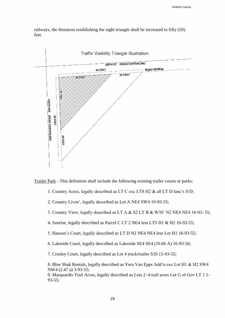
Yankton County
29
railways, the distances establishing the sight triangle shall be increased to fifty (50)
feet.
Trailer Park - This definition shall include the following existing trailer courts or parks:
1. Country Acres, legally described as LT C exc LTS H2 & all LT D lane’s S/D;
2. Country Liven’, legally described as Lot A NE4 SW4 10-93-55;
3. Country View, legally described as LT A & S2 LT B & W30’ N2 NE4 NE4 16-93- 55;
4. Sunrise, legally described as Parcel C LT 2 NE4 less LTS H1 & H2 16-93-55;
5. Hansen’s Court, legally described as LT D N2 NE4 NE4 less Lot H1 16-93-55;
6. Lakeside Court, legally described as Lakeside SE4 SE4 (10.66 A) 16-93-56;
7. Crosley Court, legally described as Lot 4 truck/trailer S/D 15-93-55;
8. Blue Shak Rentals, legally described as Vera Van Epps Add’n exc Lot H1 & H2 SW4
NW4 (2.47 a) 3-93-55;
9. Marquardts Trail Acres, legally described as Lots 2–4 trail acres Lot G of Gov LT 1 1-
93-55;
Yankton County
30
10. Lakeview, legally described as LTS F1 & F2 Fitzgerald Park & E6’ W150’ orig.
Fitzgerald Park 17-93-56;
11. Black Walnut, legally described as N2 N2 NE4 exc Parcels 17-93-56;
12. Shreve’s, legally described as Parcel A LT 5 NW4 SE4 3-93-55;
13. Eastwinds, legally described as Blk 1 Edna’s Add’n & Par A W2 SW4 SE4 10-93-55;
14. Country Manor Estates, legally described as LT 2, ex W170’ & NW4 NW4 exc
E417.4’ & S417.4’ W482.2’ S220’ N578.7’ & Parcel C exc W170’ NW4 NW4 16-93-55;
and
15. Larson’s Landing, legally described as E2 LT 2 Shore Acres 27-93-56.
Travel Trailer - A moveable vehicle with wheels designed or used as living and
sleeping quarters or for recreation or business purposes, and such vehicles that have
not had the wheels removed. Including campers, recreation vehicles, and trailer
coaches.
Truck or Equipment Terminal - A building, structure or place where six (6) or more
commercially licensed trucks are rented, leased, kept for hire, stored, or parked for
compensation, or from which trucks or transports, stored or parked on the property,
are dispatched for hire as common carriers, and which may include warehouse space.
Use - Use shall mean the purpose for which a lot or a building or structure, or any
portion thereof, is designed, arranged, intended, occupies, or maintained, and “used”
shall have a corresponding meaning.
Utility Facilities - Any above-ground structures or facilities, other than buildings,
unless such buildings are used as storage incidental to the operation of such structures
or facilities, owned by a governmental entity, a nonprofit organization, a corporation,
or any entity defined as a public utility for any purpose and used in connection with
the production, generation, transmission, delivery, collection, or storage of water,
sewage, electricity, gas, oil, or electronic signals.
Variance - A variance is a relaxation of the terms of the zoning ordinance where such
variance will not be contrary to the public interest and where, owing to conditions
peculiar to the property and not the result of the actions of the applicant, a literal
enforcement of the ordinance would result in unnecessary and undue hardship. As
used in this ordinance, a variance is authorized only for area and size of structure or
size of yards and open spaces; establishment or expansion of a use otherwise
prohibited shall not be allowed by variance, nor shall a variance be granted because of
the presence of nonconformities in the zoning district or uses in an adjoining district
or because of conditions created by the landowner.
Veterinary Clinic - A building or part of a building used for the care, diagnosis, and
treatment of sick, ailing, infirm, or injured animals, and those who are in need of
medical or surgical attention. Such clinics may or may not provide long-term lodging
Yankton County
31
for ill or unwanted animals, or lodging for healthy animals on a fee basis. No outside
runs, pens, or facilities shall be permitted.
Veterinary Service - Shall be defined as a veterinary clinic except that outside pens
and runs are allowed.
Video Rental Shop - The use of land, building or structure for the purpose of renting
video cassette recorders and/or video disc players and/or the rental of video tapes
and/or discs.
Vision Clearance - An unoccupied triangular space at the intersection of right-of-ways
with other right-of-ways or at the intersection of right-of-ways with railroads. See
Traffic Visibility Triangle.
Warehouse - A building or part of a building used for the storage and distribution of
goods, wares, merchandise, substances, or articles and may include facilities for a
wholesale or retail commercial outlet, but shall not include facilities for a truck or
transport terminal or yard.
Wholesale - The sale of commodities to retailers or jobbers and shall include the sale
of commodities for the purpose of carrying on any trade or business even if the said
trade of business is the consumer or end user of the commodity.
Wind Energy System - A structure or place, such as a wind turbine, designed and
constructed to generate power for distribution to off-site users. This definition shall
not include private facilities with a single tower or turbine less than seventy-five (75)
feet in height and not designed for distribution of power to off-site users.
Windbreak - Any non-opaque manmade structure constructed of any material and
erected adjacent to an animal feeding, calving, or other such lot of which its principal
use is that of protecting livestock from the effects of the wind.
Yard - An open space at grade, other than a court or plaza, between a structure and the
adjacent lot lines, unoccupied and unobstructed by any portion of a structure from the
ground upward.
Yard, Front - An open, unoccupied space on a lot facing a right-of-way and extending
across the front of the lot between the side lot lines; measured from the road right-of-
way to the structure.
Yard, Rear - An open, unoccupied space extending across the rear of a lot from one
side lot line to the other side lot line.
Yard, Side - An open, unoccupied space on the same lot with a building situated
between the building and sideline of the lot and extending through from the front yard
to the required rear yard. Any lot line not the rear line or a front line shall be deemed
a sideline.
Zone - An area within which, in accordance with the provisions of this Ordinance,
certain uses of lands, buildings, and structures are permitted and certain others are
prohibited, where yards and other open spaces are required, where lot areas, building
Yankton County
32
height limits, and other requirements are established, all of the foregoing being
identical for the zone and district in which they apply.
Zoning Administrator - An official of the County appointed by the Chairman and
confirmed by the County Commission, charged with the responsibility of
administrating this ordinance.

Yankton County
33
THIS PAGE RESERVED FOR FUTURE USE
Yankton County
34
ARTICLE 1
JURISDICTION
Section 101 General
This Ordinance shall be known and shall be cited and referred to as “The Official
Zoning Ordinance of Yankton County, South Dakota”, which shall be kept, updated
and located in the Yankton County Auditor’s Office. Additional copies shall be
available in the Yankton County Register of Deeds Office and the Yankton County
Planning and Zoning Office. The Yankton County Zoning Ordinance is also available
to the public on the Yankton County website online in accordance with SDCL #7-
18A-25-1. (Amended May 19, 2020)
Section 103 Jurisdiction
The provisions of this Ordinance shall apply within the unincorporated areas of
Yankton County, South Dakota, including organized and unorganized townships, and
excluding the incorporated communities of Gayville, Irene, Lesterville, Mission Hill,
Utica, Volin, and Yankton, including the extraterritorial jurisdictional area as defined
herein, as established on the map entitled “The Official Zoning Map of Yankton
County, South Dakota”.
Section 105 Provisions of this Ordinance Declared to the Minimum Requirements
In their interpretation and application, the provisions of this Ordinance shall be held
to be minimum requirements, adopted for the promotion of the public health, safety,
morals, or general welfare. Whenever the provisions of this Ordinance require a
greater width or size of yards, courts or other spaces, or require a greater percentage
of lot to be left unoccupied, or impose other higher standards than are required, in any
other Ordinance, the provisions of this Ordinance shall govern. Wherever the
provisions of any other ordinance require a greater width or size of yards, courts, or
other open spaces, or require a greater percentage of lot to be left unoccupied, or
impose other higher standards than are required by the provisions of this Ordinance,
the provisions of such Ordinance shall govern.

Yankton County
35
THIS PAGE RESERVED FOR FUTURE USE
Yankton County
36
ARTICLE 2
APPLICATION OF DISTRICT REGULATIONS
Section 201 General
The regulations, set forth by this Ordinance within each district, shall be minimum
regulations and shall apply uniformly to each class or kind of structure or land, except
as hereinafter provided.
Section 203 Zoning Affects Every Building and Use
No building, structure, or land shall hereafter be used or occupied, and no building or
structure or part thereof shall hereafter be erected, constructed, reconstructed, or
moved, except in conformity with all of the regulations herein specified. (Amended
May 19, 2020)
Section 205 Performance Standards
No building or other structure shall hereafter be erected or altered, without obtaining a
permit, to:
1. Accommodate or house a greater number of families;
2. Occupy a greater area of the lot; or
3. Have narrower or smaller rear yards, front yards, side yards, or other open
spaces.
Section 207 Yard, Lot, and Parcel Reduction (Amended May 19, 2020)
The reduction of any existing yard, lot or parcel in dimension or area below the
minimum requirements set forth herein must follow variance procedures in sections
1807 and 1907. (Amended May 19, 2020)
The creation of any new yard, lot, or parcel with dimensions or area below the
minimum requirements set forth herein must also follow variance procedures in
sections 1807 and 1907. (Amended May 19, 2020)

Yankton County
37
THIS PAGE RESERVED FOR FUTURE USE
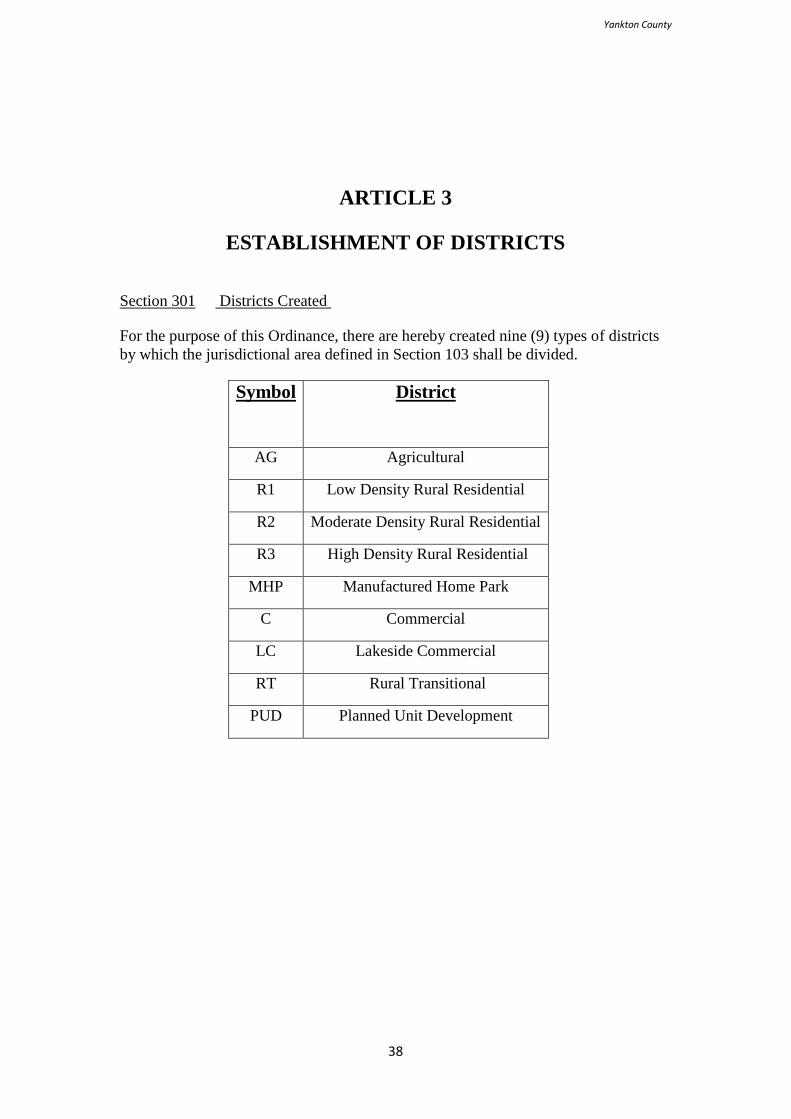
Yankton County
38
ARTICLE 3
ESTABLISHMENT OF DISTRICTS
Section 301 Districts Created
For the purpose of this Ordinance, there are hereby created nine (9) types of districts
by which the jurisdictional area defined in Section 103 shall be divided.
Symbol
District
AG Agricultural
R1 Low Density Rural Residential
R2 Moderate Density Rural Residential
R3 High Density Rural Residential
MHP Manufactured Home Park
C Commercial
LC Lakeside Commercial
RT Rural Transitional
PUD Planned Unit Development

Yankton County
39
THIS PAGE RESERVED FOR FUTURE USE
Yankton County
40
ARTICLE 4
OFFICIAL ZONING MAP AND BOUNDARY
INTERPRETATION
Section 401 General
The County is hereby divided into zones, or districts, as shown on the Official Zoning
Map, which, together with all explanatory matter thereon, is hereby adopted by
reference and declared to be a part of this Ordinance. The Official Zoning Map shall
be identified by the signature of the Chairman of the County Commissioners, attested
by the Auditor, and bearing the seal of the County, under the following words: "This
is to certify that this is the Official Zoning Map referred to in Section 401 of
Ordinance No. 16 of “Yankton County, South Dakota,” together with the date of the
adoption of this Ordinance.
Section 403 Zoning Map Changes
If, in accordance with the provisions of this Ordinance, changes are made in the
district boundaries or other matter portrayed on the Official Zoning Map, such
changes shall be entered on the Official Zoning Map promptly after the amendment
has been approved by the County Commissioners, with an entry on the Official
Zoning Map as follows: “on [date], by official action of the Yankton County
Commission, the following [change] changes were made in the Official Zoning Map:
[brief description of nature of change],” which entry shall be signed by the Chairman
of the Commission and attested by the Auditor. No amendment to this Ordinance
which involves matters portrayed on the Official Zoning Map shall become effective
until after such change and entry has been made on said map.
No changes of any nature shall be made in the Official Zoning Map or matters shown
thereon except in conformity with the procedures set forth in this Ordinance.
Any unauthorized change of whatever kind by any person or persons shall be
considered a violation of this Ordinance and punishable as provided under Section
2303.
Regardless of the existence of purported copies of the Official Zoning Map which
may, from time to time, be made or published, the Official Zoning Map which shall
be located in the office of the Zoning Administrator shall be the final authority as to
the current zoning status of land and water areas, buildings, and other structures in the
County.
Section 405 Zoning Map Replacement
Yankton County
41
In the event that the Official Zoning Map becomes damaged, destroyed, lost or
difficult to interpret because of the nature or number of changes and additions, the
Yankton County Commission may, by resolution, adopt a new Official Zoning Map,
which shall supersede the prior Official Zoning Map.
The new Official Zoning Map may correct drafting or other errors or omissions in the
prior Official Zoning Map, but no such correction shall have the effect of amending
the original Official Zoning Map or any subsequent amendment thereof.
The new Official Zoning Map shall be identified by the signature of the Chairman of
the County Commission, attested by the Auditor, and bearing the seal of the County,
under the following words:
“This is to certify that this Official Zoning Map supersedes and
replaces the Official Zoning Map adopted [date of adoption of
map being replaced] as part of Ordinance No. 16 of “Yankton
County, South Dakota.”
Unless the prior Official Zoning Map has been lost, or has been totally destroyed, the
prior map or any significant parts thereof remaining shall be preserved, together with
all available records pertaining to its adoption or amendment.
Section 407 Rules for Interpretation of District Boundaries
Where uncertainty exists as to the boundaries of districts as shown on the Official
Zoning Map, the following rules shall apply:
1. Boundaries indicated, as approximately following the centerlines of right-of-
ways, roads, highways, or alleys shall be construed to follow such centerlines;
2. Boundaries indicated as approximately following platted lot lines shall be
construed as following such lot lines;
3. Boundaries indicated, as approximately following city limits shall be
construed as following such city limits;
4. Boundaries indicated, as following railroad lines shall be construed to be
midway between the main tracks;
5. Boundaries indicated as following shore lines shall be construed to follow
such shore lines, and in the event of change in the shore line shall be construed
as moving with the actual shore line; boundaries indicated as approximately
following the center line of streams, rivers, canals, lakes, or other bodies of
water shall be construed to follow such center lines;
6. Boundaries indicated as parallel to or extensions of features indicated in
subsections 1 through 5 above shall be so construed. The scale of the map
shall determine distances not specifically indicated on the Official Zoning
Map; and

Yankton County
42
Where physical or cultural features existing on the ground are at variance with those
shown on the Official Zoning Map, or in other circumstances not covered by
subsections 1 through 6 above, the Planning Commission shall interpret the district
boundaries.
THIS PAGE RESERVED FOR FUTURE USE
Yankton County
43
ARTICLE 5
AGRICULTURAL DISTRICT (AG)
Section 501 Intent
The intent of Agricultural Districts (AG) is to protect agricultural lands and lands
consisting of natural growth from incompatible land uses in order to preserve land
best suited to agricultural uses and land in which the natural environment should be
continued and to limit residential, commercial, and industrial development to those
areas where they are best suited for reasons of practicality and service delivery.
Section 503 Permitted Principal Uses and Structures
The following principal uses and structures shall be permitted in an Agricultural
District (AG):
1. Agriculture;
2. Cemeteries;
3. Day cares, family;
4. Dwellings, single-family;
5. Farms;
6. Farm buildings;
7. Historic sites;
8. Horticulture;
9. Manufactured homes, pursuant to Section 1509;
10. Modular homes;
11. Utility facilities; and
12. Veterinary services.
Section 505 Permitted Accessory Uses and Structures
The following accessory uses and structures shall be permitted in an Agricultural
District (AG):
Yankton County
44
1. Accessory agricultural structures;
2. Customary water irrigation systems, other than manure irrigation equipment;
3. Farm drainage systems;
4. Home and farm occupations;
5. Roadside stands;
6. Shelterbelts;
7. Signs, banner;
8. Signs, directional on-site;
9. Signs, directional off-site;
10. Signs, easement and utility;
11. Signs, exterior off-site, pursuant to Article 14;
12. Signs, flag;
13. Signs, name and address plate;
14. Signs, on-site;
15. Signs, real estate; and
16. Stock dams.
Section 507 Conditional Uses
After the provisions of this Ordinance relating to conditional uses have been fulfilled,
the Board of Adjustment may permit as conditional uses in an Agricultural District
(AG):
1. Animal feeding operations;
2. Agricultural, fertilizer, and chemical sales and applications;
3. Agricultural product processing facilities;
4. Aquaculture;
5. Auction yards and barns;
6. Bars;
7. Bed and breakfast operations;
8. Buying stations;
Yankton County
45
9. Churches;
10. Construction services;
11. Day cares, group family home;
12. Dwellings, additional farm in excess of one (1), pursuant to Sections 513(5)
and 1509;
13. Exhibition areas;
14. Fairgrounds;
15. Fireworks sales;
16. Game farms;
17. Game lodges;
18. Golf courses;
19. Grain elevators;
20. Individual septic or sewage treatment facilities, pursuant to Section 1513;
21. Indoor shooting/archery ranges;
22. Kennels;
23. Landing Strips;
24. Manufacturing, light;
25. Motor vehicle tracks or play areas;
26. Manure irrigation;
27. Municipal, commercial, or residential central containment, sewage disposal,
treatment, or application sites;
28. Open sales areas;
29. Outdoor shooting/archery ranges;
30. Parks;
31. Portable processing plants;
32. Private recreation areas;
33. Private shooting preserves;
34. Quarries, pursuant to Section 1515;
Yankton County
46
35. Remote fuel depots;
36. Repair shops, auto-body;
37. Repair shops, motor vehicle and equipment;
38. Riding stables;
39. Rodeo arenas;
40. Salvage yards;
41. Sanitary landfills or restricted use sites, permitted by the Department of
Environment and Natural Resources (DENR);
42. Spreading, injection, or other application of manure or animal waste generated
by an Animal Feeding Operation as described herein, or other livestock
production means located outside of Yankton County pursuant to Section 519
(11) (12);
43. Swimming pools;
44. Temporary construction facilities; and
45. Towers, pursuant to Article 25 & Article 26;
46. Wildlife and game production areas; and
47. Wind energy systems, pursuant to Article 26.
Section 509 Classification of Unlisted Uses
In order to insure that the zoning ordinance will permit all similar uses in each
district, the Planning Commission and Board of Adjustment, upon its own initiative or
upon written application, shall determine whether a use not specifically listed as a
permitted, accessory, or conditional use in a Agricultural District shall be deemed a
permitted, accessory, or conditional use in one or more districts on the basis of
similarity to uses specifically listed. The review shall be heard at a regular meeting of
the aforementioned bodies and may be required to adhere to the notification
requirements as described in Section 1803(3-5).
Section 511 Prohibited Uses and Structures
All uses and structures which are not specifically permitted as principal, accessory, or
conditional uses or approved as such within the provisions of Section 509 shall be
prohibited.
Section 513 Minimum Lot Requirements
1. The minimum lot area shall be twenty (20) acres;
2. The minimum lot width shall be five hundred (500) feet;

Yankton County
47
3. The Zoning Administrator may allow a smaller minimum lot requirement
where a permit for a single-family home is requested on an existing farmstead
site, as defined herein;
4. Lots of record, as defined herein, existing prior to adoption of this ordinance
may be developed pursuant to Article 16 and as approved by the Zoning
Administrator;
5. An additional dwelling unit is allowed within the farmstead upon approval of
the building permit application if it is to be occupied by other members of the
family farm unit, provided the property is not transacted or prepared, platted,
or described for transaction; and
6. The Zoning Administrator may allow construction of single and multi-family
dwelling units not in conformance with this provision only on those lands
organized as a 501(d), non-profit religious and apostolic associations as
described in the United States Tax Code. Prior to issuance of a building permit
or permission to proceed said entity shall file the Articles of Incorporation and
other requested documentation with the Zoning Administrator. Construction
activities carried on under this provision shall be in conformance with all other
provisions of this ordinance.
Section 515 Minimum Yard Requirements
All yards must meet the following criteria as measured from the lot lines. This Section
shall apply to all buildings and structures, including but not limited to decks and
patios:
1. There shall be a front yard of not less than a depth of seventy five (75) feet;
2. There shall be a rear yard of not less than a depth of seventy five (75) feet;
3. There shall be two (2) side yards, each of which shall not be less than seventy
five (75) feet;
4. Buildings and structures on corner lots as defined herein shall maintain two
(2) front yards for the property abutting the road right-of-ways; and
5. The Zoning Administrator may allow construction of single and multi-family
dwelling units not in conformance with this provision only on those lands
organized as a 501(d), non-profit religious and apostolic associations as
described in the United States Tax Code. Prior to issuance of a building permit
or permission to proceed said entity shall file the Articles of Incorporation and
other requested documentation with the Zoning Administrator. Construction
activities carried on under this provision shall be in conformance with all other
provisions of this ordinance.
Section 517 Traffic Visibility
Yankton County
48
1. There shall be no obstructions, such as buildings, structures, grain bins, trees,
wind breaks, baled agricultural products, or other objects within fifty (50) feet
from the right-of-way.
2. A traffic visibility triangle as defined herein shall be maintained at all road
intersections, public and private, driveways, railway crossings, or similar
situation as determined by the Zoning Administrator; and
3. Structures, perennial, or similar vegetation planted on or immediately
adjacent to a road right-of-way public shall be approved in writing by
the Zoning Administrator prior to construction or planting. No such
vegetation between the heights of thirty (30) inches and ten (10) feet
shall encroach upon the right-of-way at the time of planting or future
growth. The Zoning Administrator reserves the right to refer such
requests to Township Supervisors, the County Highway
Superintendent, or other officials.
Section 519 Animal Feeding Operation Performance Standards
Animal Feeding Operations are considered conditional uses and shall comply with the
Conditional Use Process, all applicable state and federal requirements, and the
applicable requirements as defined in this section:
Class A (5,000 – 10,000) Section 519(1,2,3,4,5,6,7(a),8(a),9,10,11,12,13)
Class B (3,000 – 4,999) Section 519(1,2,3,4,5,6,7(b),8(b),9,10,11,12,13)
Class C (2,000 – 2,999) Section 519(1,2,3,4,5,7(c),8(c),9,10,11,12,13)
Class D (1,000 – 1,999 ) Section 519(1,2,3,4,5,7(d),8(d),9,10,11,12,13)
Class E (300 – 999) Section 519(2,3,4*,5,7(e),8(e),9,10,11,12,13)
Class F (1 – 299) NA
*If required by state law
1. Animal Feeding Operations shall submit animal waste management system
plans and specifications for review and approval prior to construction, and a
Notice of Completion for a Certificate of Compliance, after construction, to
the South Dakota Department of Environment and Natural Resources or as
amended by the State of South Dakota or the South Dakota Department of
Environment and Natural Resources.
2. Prior to construction, such facilities shall obtain a Storm Water Permit for
Construction Activities from the South Dakota Department of Environment
and Natural Resources. The Storm Water Pollution Prevention Plan required
by the permit must be developed and implemented upon the start of
construction.
3. Animal confinement and waste facilities shall comply with the following
facility setback requirements:
A. Public Wells 1,000 feet
Yankton County
49
B. Private Wells 250 feet
C. Private Wells (Operator’s) 150 feet
D. Lakes, Rivers, Streams Classified as a Public
Drinking Water Supply 1,000 feet
E. Lakes, Rivers, Streams Classified as Fisheries 1,000 feet
F. Designated 100 Year Flood Plain PROHIBITED
4. Applicants must present a nutrient management plan to the Department of
Environment and Natural Resources for approval and/or certification.
Examples of such management shall include at least:
A. Proposed maintenance of waste facilities;
B. Land application process and/or methods;
C. Legal description and map, including documented proof of area to be
utilized for nutrient application; and
D. All CAFO’s are required to obtain a South Dakota State General Permit
that outlines the manure management practices that an operator must
follow to prevent water pollution and protect public health.
5. New animal feeding operations, new CAFO’s and waste facilities shall be
setback six hundred and sixty six (660) feet from a property line delineating a
change in ownership and three hundred and thirty (330) feet from a right-a-
way line. Additionally, the applicant shall locate the operation ¼ of a mile or
1,320 feet from neighboring residential dwellings. The Planning Commission
and/or Board of Adjustment may mandate setbacks greater than those required
herein to further the intent of the Zoning Ordinance while protecting the
public health, safety, and welfare.
6. New Class A and B Animal Feeding Operations shall be prohibited from
locating within the area bounded by the City of Yankton, 431st Avenue, the
Missouri River, and South Dakota Highway 50.
7. New animal confinement and waste facilities shall be located no closer than
the following regulations prescribe from any Class I incorporated municipality
or residentially zoned area bounded by the City of Yankton, 431st
Avenue, the
Missouri River and South of South Dakota Highway 50:
A. Class A 4 miles
B. Class B 2 miles
C. Class C 1 mile
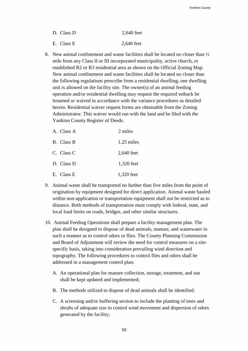
Yankton County
50
D. Class D 2,640 feet
E. Class E 2,640 feet
8. New animal confinement and waste facilities shall be located no closer than ½
mile from any Class II or III incorporated municipality, active church, or
established R2 or R3 residential area as shown on the Official Zoning Map.
New animal confinement and waste facilities shall be located no closer than
the following regulations prescribe from a residential dwelling; one dwelling
unit is allowed on the facility site. The owner(s) of an animal feeding
operation and/or residential dwelling may request the required setback be
lessened or waived in accordance with the variance procedures as detailed
herein. Residential waiver request forms are obtainable from the Zoning
Administrator. This waiver would run with the land and be filed with the
Yankton County Register of Deeds.
A. Class A 2 miles
B. Class B 1.25 miles
C. Class C 2,640 feet
D. Class D 1,320 feet
E. Class E 1,320 feet
9. Animal waste shall be transported no further than five miles from the point of
origination by equipment designed for direct application. Animal waste hauled
within non-application or transportation equipment shall not be restricted as to
distance. Both methods of transportation must comply with federal, state, and
local load limits on roads, bridges, and other similar structures.
10. Animal Feeding Operations shall prepare a facility management plan. The
plan shall be designed to dispose of dead animals, manure, and wastewater in
such a manner as to control odors or flies. The County Planning Commission
and Board of Adjustment will review the need for control measures on a site-
specific basis, taking into consideration prevailing wind direction and
topography. The following procedures to control flies and odors shall be
addressed in a management control plan:
A. An operational plan for manure collection, storage, treatment, and use
shall be kept updated and implemented;
B. The methods utilized to dispose of dead animals shall be identified.
C. A screening and/or buffering section to include the planting of trees and
shrubs of adequate size to control wind movement and dispersion of odors
generated by the facility;
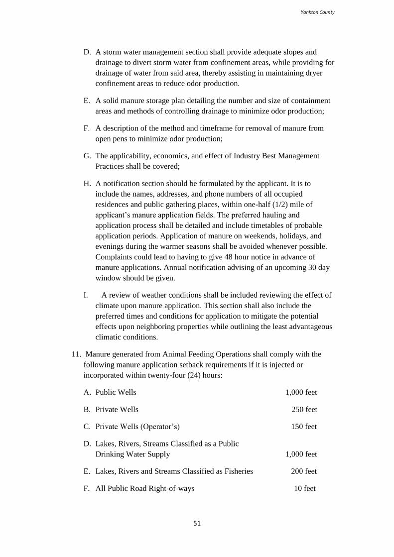
Yankton County
51
D. A storm water management section shall provide adequate slopes and
drainage to divert storm water from confinement areas, while providing for
drainage of water from said area, thereby assisting in maintaining dryer
confinement areas to reduce odor production.
E. A solid manure storage plan detailing the number and size of containment
areas and methods of controlling drainage to minimize odor production;
F. A description of the method and timeframe for removal of manure from
open pens to minimize odor production;
G. The applicability, economics, and effect of Industry Best Management
Practices shall be covered;
H. A notification section should be formulated by the applicant. It is to
include the names, addresses, and phone numbers of all occupied
residences and public gathering places, within one-half (1/2) mile of
applicant’s manure application fields. The preferred hauling and
application process shall be detailed and include timetables of probable
application periods. Application of manure on weekends, holidays, and
evenings during the warmer seasons shall be avoided whenever possible.
Complaints could lead to having to give 48 hour notice in advance of
manure applications. Annual notification advising of an upcoming 30 day
window should be given.
I. A review of weather conditions shall be included reviewing the effect of
climate upon manure application. This section shall also include the
preferred times and conditions for application to mitigate the potential
effects upon neighboring properties while outlining the least advantageous
climatic conditions.
11. Manure generated from Animal Feeding Operations shall comply with the
following manure application setback requirements if it is injected or
incorporated within twenty-four (24) hours:
A. Public Wells 1,000 feet
B. Private Wells 250 feet
C. Private Wells (Operator’s) 150 feet
D. Lakes, Rivers, Streams Classified as a Public
Drinking Water Supply 1,000 feet
E. Lakes, Rivers and Streams Classified as Fisheries 200 feet
F. All Public Road Right-of-ways 10 feet
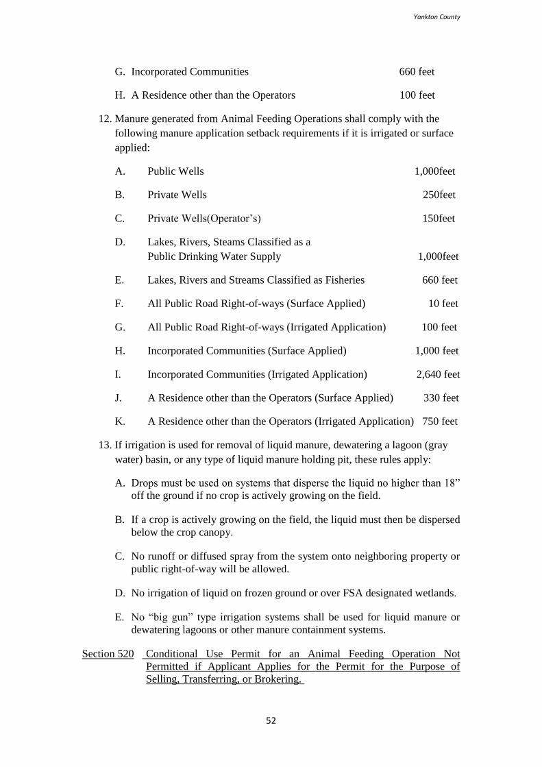
Yankton County
52
G. Incorporated Communities 660 feet
H. A Residence other than the Operators 100 feet
12. Manure generated from Animal Feeding Operations shall comply with the
following manure application setback requirements if it is irrigated or surface
applied:
A. Public Wells 1,000feet
B. Private Wells 250feet
C. Private Wells(Operator’s) 150feet
D. Lakes, Rivers, Steams Classified as a
Public Drinking Water Supply 1,000feet
E. Lakes, Rivers and Streams Classified as Fisheries 660 feet
F. All Public Road Right-of-ways (Surface Applied) 10 feet
G. All Public Road Right-of-ways (Irrigated Application) 100 feet
H. Incorporated Communities (Surface Applied) 1,000 feet
I. Incorporated Communities (Irrigated Application) 2,640 feet
J. A Residence other than the Operators (Surface Applied) 330 feet
K. A Residence other than the Operators (Irrigated Application) 750 feet
13. If irrigation is used for removal of liquid manure, dewatering a lagoon (gray
water) basin, or any type of liquid manure holding pit, these rules apply:
A. Drops must be used on systems that disperse the liquid no higher than 18”
off the ground if no crop is actively growing on the field.
B. If a crop is actively growing on the field, the liquid must then be dispersed
below the crop canopy.
C. No runoff or diffused spray from the system onto neighboring property or
public right-of-way will be allowed.
D. No irrigation of liquid on frozen ground or over FSA designated wetlands.
E. No “big gun” type irrigation systems shall be used for liquid manure or
dewatering lagoons or other manure containment systems.
Section 520 Conditional Use Permit for an Animal Feeding Operation Not
Permitted if Applicant Applies for the Permit for the Purpose of
Selling, Transferring, or Brokering.
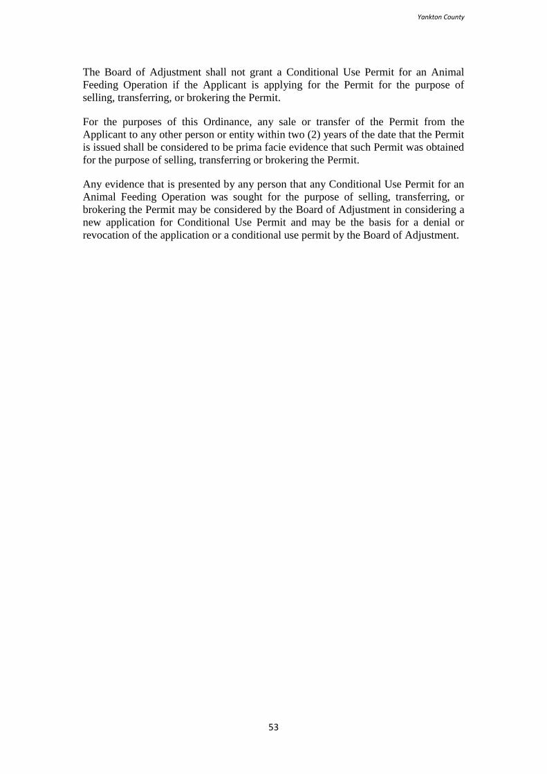
Yankton County
53
The Board of Adjustment shall not grant a Conditional Use Permit for an Animal
Feeding Operation if the Applicant is applying for the Permit for the purpose of
selling, transferring, or brokering the Permit.
For the purposes of this Ordinance, any sale or transfer of the Permit from the
Applicant to any other person or entity within two (2) years of the date that the Permit
is issued shall be considered to be prima facie evidence that such Permit was obtained
for the purpose of selling, transferring or brokering the Permit.
Any evidence that is presented by any person that any Conditional Use Permit for an
Animal Feeding Operation was sought for the purpose of selling, transferring, or
brokering the Permit may be considered by the Board of Adjustment in considering a
new application for Conditional Use Permit and may be the basis for a denial or
revocation of the application or a conditional use permit by the Board of Adjustment.

Yankton County
54
THIS PAGE RESERVED FOR FUTURE USE
Yankton County
55
ARTICLE 6
LOW DENSITY RURAL RESIDENTIAL DISTRICT (R1)
Section 601 Intent
The intent of Low Density Rural Residential Districts (R1) is to provide for
residential uses of larger lots and other compatible uses in a pleasant and stable
environment.
Section 603 Permitted Principal Uses and Structures
The following principal uses and structures shall be permitted in a Low Density Rural
Residential District (R1):
1. Day cares, family;
2. Dwellings, single-family;
3. Governmental services;
4. Horticulture;
5. Modular homes; and
6. Utility facilities.
Section 605 Permitted Accessory Uses and Structures
The following accessory uses and structures shall be permitted in a Low Density
Rural Residential District (R1):
1. An aggregate maximum total floor area of 4,000 square foot accessory
building or buildings. Side wall height shall not exceed sixteen (16) feet as
measured from the highest point of the finished floor at grade to the highest
point of wall framing. (Amended May 19, 2020)
2. Home occupations;
3. Signs, banner;
Yankton County
56
4. Signs, directional on-site;
5. Signs, directional off-site;
6. Signs, easement and utility;
7. Signs, flag;
8. Signs, name and address plate; and
9. Signs, real estate.
Section 607 Conditional Uses
After the provisions of this Ordinance, relating to conditional uses have been fulfilled,
the Board of Adjustment may permit as conditional uses in a Low Density Rural
Residential District (R1):
1. Accessory agricultural structures;
2. Bed and breakfasts;
3. Campgrounds;
4. Cemeteries;
5. Home based sales;
6. Greenhouses;
7. Golf courses;
8. Hobby farms;
9. Horticultural sales;
10. Kennels;
11. Manufactured homes, pursuant to Section 1507;
12. Manufacturing, light;
13. Parks;
14. Signs, off-site;
15. Swimming pools; and
Yankton County
57
16. Towers.
17. One Accessory Structure exceeding 4,000 square feet or Accessory Structures
with an aggregate maximum total floor area exceeding 4,000 square feet
and/or exceeding a sidewall height of sixteen (16) feet. (Amended May 19, 2020)
Section 609 Classification of Unlisted Uses
In order to insure that the zoning ordinance will permit all similar uses in each
district, the Board of Adjustment, upon its own initiative or upon written application,
shall determine whether a use not specifically listed as a permitted, accessory, or
conditional use in a Low Density Residential District shall be deemed a permitted,
accessory, or conditional use in one or more districts on the basis of similarity to uses
specifically listed. The review shall be heard at a regular meeting of the
aforementioned bodies and may be required to adhere to the notification requirements
as described in Section 1803(3-5).
Section 611 Prohibited Uses and Structures
All uses and structures, which are not specifically permitted as principal, accessory, or
conditional uses or approved as such within the provisions of Section 609, shall be
prohibited.
Section 613 Minimum Lot Requirements
1. The minimum lot area shall be five (5) acres; and
2. The minimum lot width shall be two hundred (200) feet.
Section 615 Minimum Yard Requirements
All yards must meet the following criteria as measured from the lot lines. This Section
shall apply to all buildings and structures, including but not limited to decks, patios,
and carports:
1. There shall be a front yard of not less than a depth of thirty (30) feet, except
when said lot is adjacent to or abutting a arterial or collector right-of-way then
the depth shall be fifty (50) feet;
2. There shall be a rear yard of not less than a depth of twenty (20) feet;
3. There shall be two (2) side yards, each of which shall not be less than ten (10)
feet; and
4. Buildings and structures on corner lots as defined herein shall maintain two
(2) front yards for the property abutting the road right-of-ways.
Section 617 Traffic Visibility
1. A traffic visibility triangle as defined herein shall be maintained at all road
intersections, public and private, driveways, railway crossings, or similar
Yankton County
58
situation as determined by the Zoning Administrator; and
2. Structures, perennial, or similar vegetation planted on or immediately adjacent
to a road right-of-way public shall be approved in writing by the Zoning
Administrator prior to construction or planting. No such vegetation between
the heights of thirty (30) inches and ten (10) feet shall encroach upon the
right-of-way at the time of planting or future growth. The Zoning
Administrator reserves the right to refer such requests to Township
Supervisors, the County Highway Superintendent, or other officials.

Yankton County
59
THIS PAGE RESERVED FOR FUTURE USE
Yankton County
60
ARTICLE 7
MODERATE DENSITY RURAL RESIDENTIAL
DISTRICT (R2)
Section 701 Intent
The intent of Moderate Density Rural Residential Districts (R2) is to provide for
residential uses of moderate lots and other compatible uses in a pleasant and stable
environment.
Section 703 Permitted Principal Uses and Structures
The following principal uses and structures shall be permitted in a Moderate Density
Rural Residential District (R2):
1. Day cares, family;
2. Dwellings, single-family;
3. Governmental services;
4. Horticulture;
5. Modular homes; and
6. Utility facilities.
Section 705 Permitted Accessory Uses and Structures
The following accessory uses and structures shall be permitted in a Moderate Density
Rural Residential District (R2):
1. An aggregate maximum total floor area of 2,400 square foot accessory
structure or structures. Side wall height shall not exceed fourteen (14) feet as
measured from the highest point of the finished floor at grade to the highest
point of wall framing. (Amended May 19, 2020)
2. Home occupations;
3. Signs, banner;
4. Signs, directional on-site;
Yankton County
61
5. Signs, directional off-site;
6. Signs, easement and utility;
7. Signs, flag;
8. Signs, name and address plate; and
9. Signs, real estate.
Section 707 Conditional Uses
After the provisions of this Ordinance, relating to conditional uses have been fulfilled,
the Board of Adjustment may permit as conditional uses in a Moderate Density Rural
Residential District (R2):
1. Bed and breakfasts;
2. Campgrounds, pursuant to 1521;
3. Churches;
4. Day cares, group family home;
5. Dwellings, multi-family;
6. Dwellings, two family;
7. Manufactured homes, pursuant to Section 1507;
8. Parks;
9. Schools, public;
10. Signs, off-site;
11. Swimming pools; and
12. Towers.
13. One Accessory Structure exceeding 2,400 square feet or Accessory Structures
with an aggregate maximum total floor area exceeding 2,400 square feet
and/or exceeding a sidewall height of fourteen (14) feet. (Amended May 19,
2020)
Section 709 Classification of Unlisted Uses
In order to insure that the zoning ordinance will permit all similar uses in each
district, the Board of Adjustment, upon its own initiative or upon written application,
shall determine whether a use not specifically listed as a permitted, accessory, or
conditional use in a Moderate Density Residential District shall be deemed a
permitted, accessory, or conditional use in one or more districts on the basis of
Yankton County
62
similarity to uses specifically listed.
Section 711 Prohibited Uses and Structures
All uses and structures which are not specifically permitted as principal, accessory, or
conditional uses or approved as such within the provisions of Section 709 shall be
prohibited.
Section 713 Minimum Lot Requirements
1. The minimum lot area shall be one (1) acre or forty thousand (40,000) square
feet;
2. The minimum lot area for multi-family dwellings in areas of two (2) units
shall be one (1) acre or forty thousand (40,000) square feet and an additional
five thousand (5,000) square feet for each unit in excess of the first two (2);
and
3. The minimum lot width shall be one hundred (100) feet.
Section 715 Minimum Yard Requirements
All yards must meet the following criteria as measured from the lot lines. This Section
shall apply to all buildings and structures, including but not limited to decks, patios,
and carports:
1. There shall be a front yard of not less than a depth of thirty (30) feet, except
when said lot is adjacent to or abutting a arterial or collector right-of-way then
the depth shall be fifty (50) feet;
2. There shall be a rear yard of not less than a depth of twenty (20) feet;
3. There shall be two (2) side yards, each of which shall not be less than ten (10)
feet;
4. Buildings and structures on corner lots as defined herein shall maintain two
(2) front yards for the property abutting the road right-of-ways.
Section 717 Traffic Visibility
1. A traffic visibility triangle as defined herein shall be maintained at all road
intersections, public and private, driveways, railway crossings, or similar
situation as determined by the Zoning Administrator; and
2. Structures, perennial or similar vegetation planted on or immediately
adjacent to a road right-of-way public shall be approved in writing by
the Zoning Administrator prior to construction or planting. No such
vegetation between the heights of thirty (30) inches and ten (10) feet
shall encroach upon the right-of-way at the time of planting or future

Yankton County
63
growth. The Zoning Administrator reserves the right to refer such
requests to Township Supervisors, the County Highway
Superintendent, or other officials.
THIS PAGE RESERVED FOR FUTURE USE
Yankton County
64
ARTICLE 8
HIGH DENSITY RURAL RESIDENTIAL DISTRICT (R3)
Section 801 Intent
The intent of High Density Rural Residential Districts (R3) is to provide existing
concentrated residential subdivisions as recorded with the Register of Deeds and other
compatible uses a pleasant and stable environment. Yet, not allow an extension of
these areas beyond their respective boundaries as recorded at the time of zoning
ordinance adoption.
Section 803 Permitted Principal Uses and Structures
The following principal uses and structures shall be permitted in a High Density Rural
Residential Districts (R3):
1. Day cares, family;
2. Dwellings, single-family;
3. Governmental services; and
4. Horticulture;
5. Modular homes;
6. Utility facilities;
Section 805 Permitted Accessory Uses and Structures
The following accessory uses and structures shall be permitted in a High Density
Rural Residential Districts (R3):
1. An aggregate maximum total floor area of 1,600 square foot accessory
structure or structures. Side wall height shall not exceed twelve (12) feet as
measured from the highest point of the finished floor at grade to the highest
point of wall framing. (Amended May 19, 2020)
2. Home occupations;
3. Signs, banner;
Yankton County
65
4. Signs, directional on-site;
5. Signs, directional off-site;
6. Signs, easement and utility;
7. Signs, flag;
8. Signs, name and address plate; and
9. Signs, real estate.
Section 807 Conditional Uses
After the provisions of this Ordinance, relating to conditional uses have been fulfilled,
the Board of Adjustment may permit as conditional uses in a High Density Rural
Residential Districts (R3):
1. Day cares, group family home;
2. Dwellings, multi-family;
3. Dwellings, two family;
4. Manufactured homes, pursuant to Section 1507;
5. Parks;
6. Signs, off-site;
7. Swimming pools; and
8. Towers.
9. One Accessory Structure exceeding 1,600 square feet or Accessory Structures
with an aggregate maximum floor area exceeding 1,600 square feet and/or
exceeding a sidewall height of twelve (12) feet. (Amended May 19, 2020)
Section 809 Classification of Unlisted Uses
In order to insure that the zoning ordinance will permit all similar uses in each
district, the Board of Adjustment, upon its own initiative or upon written application,
shall determine whether a use not specifically listed as a permitted, accessory, or
conditional use in a High Density Residential District shall be deemed a permitted,
accessory, or conditional use in one or more districts on the basis of similarity to uses
specifically listed.
Section 811 Prohibited Uses and Structures
All uses and structures which are not specifically permitted as principal, accessory, or
conditional uses or approved as such within the provisions of Section 809 shall be
prohibited.
Yankton County
66
Section 813 Minimum Lot Requirements
1. The minimum lot area shall be one-half (1/2) acre or twenty thousand (20,000)
square feet;
2. The minimum lot area for multi-family dwellings shall be one-half (1/2) acre
or twenty thousand (20,000) square feet and an additional five thousand
(5,000) square feet for each unit in excess of the first two (2); and
3. The minimum lot width shall be seventy five (75) feet.
Section 815 Minimum Yard Requirements
All yards must meet the following criteria as measured from the lot lines. This Section
shall apply to all buildings and structures, including but not limited to decks, patios,
and carports:
1. There shall be a front yard of not less than a depth of thirty (30) feet, except
when said lot is adjacent to or abutting an arterial or collector right-of-way
then the depth shall be fifty (50) feet;
2. There shall be a rear yard of not less than a depth of twenty (20) feet;
3. There shall be two (2) side yards, each of which shall not be less than ten (10)
feet; and
4. Buildings and structures on corner lots as defined herein shall maintain two
(2) front yards for the property abutting the road right-of-ways.
Section 817 Traffic Visibility
1. A traffic visibility triangle as defined herein shall be maintained at all road
intersections, public and private, driveways, railway crossings, or similar
situation as determined by the Zoning Administrator; and
2. Structures, perennial or similar vegetation planted on or immediately
adjacent to a road right-of-way public shall be approved in writing by
the Zoning Administrator prior to construction or planting. No such
vegetation between the heights of thirty (30) inches and ten (10) feet
shall encroach upon the right-of-way at the time of planting or future
growth. The Zoning Administrator reserves the right to refer such
requests to Township Supervisors, the County Highway
Superintendent, or other officials.

Yankton County
67
THIS PAGE RESERVED FOR FUTURE USE
Yankton County
68
ARTICLE 9
MANUFACTURED HOME PARK DISTRICT (MHP)
Section 901 Intent
The intent of the Manufactured Home Park District (MHP) is to preserve and enhance
property values by providing designated, distinctive areas in which manufactured
homes may be situated as a residential dwelling. It is the intent that this district be a
desirable, prominent area providing adequate open space and essentially the same
considerations given to citizens of other residential districts.
Section 903 Permitted Principal Uses and Structures
The following principal uses and structures shall be permitted in a Manufactured
Home Park District (MHP):
1. Dwellings, single family;
2. Manufactured homes, pursuant to Section 1409;
3. Modular homes;
4. Parks; and
5. Utility facilities.
Section 905 Permitted Accessory Uses and Structures
The following accessory uses and structures shall be permitted in a Manufactured
Home Park District (MHP):
1. Accessory buildings;
2. Garages;
3. Home occupations;
4. Signs, banner;
5. Signs, directional on-site;
Yankton County
69
6. Signs, directional off-site;
7. Signs, easement and utility;
8. Signs, flag;
9. Signs, name and address plate; and
10. Signs, real estate.
It shall be unlawful for any person, firm, or corporation to use any van body, truck
body, semi-trailer, rail car, “shipping crate”, and/or any vehicle no longer used for its
manufactured purpose as a storage shed, storage building, warehouse, or as living
quarters. In addition, manufactured homes shall not be for any purpose other than
residential living quarters. However, this shall not prevent the lawful parking of
vehicles properly licensed, insured, and in regular use for their intended purpose to
include ‘RVs’ and camping trailers.
Section 907 Conditional Uses
After the provisions relating to conditional uses have been fulfilled, the Board of
Adjustment may permit as conditional uses in a Manufactured Home Park District
(MHP):
1. Day care centers;
2. Day cares, family;
3. Day cares, group family home;
4. Dwellings, two family;
5. Laundry facilities;
6. Self-storage warehouses;
7. Signs, bulletin board;
8. Signs, ground and monument;
9. Signs, mounted wall;
10. Signs, off-site;
11. Signs, portable;
12. Swimming pools; and
13. Towers
Section 909 Classification of Unlisted Uses
Yankton County
70
In order to insure that the zoning ordinance will permit all similar uses in each
district, the Board of Adjustment, upon its own initiative or upon written application,
shall determine whether a use not specifically listed as a permitted, accessory, or
conditional use in a District shall be deemed a permitted, accessory, or conditional use
in one or more districts on the basis of similarity to uses specifically listed.
Section 911 Prohibited Uses and Structures
No part of any park shall be used for nonresidential purposes, except such uses that
are required for the direct servicing and well-being of park residents and for the
management and maintenance of the park. (Amended May 19, 2020)
Section 913 Minimum Lot Requirements
1. The minimum park size is three (3) acres;
2. The minimum park width is three hundred (300) feet;
3. The minimum lot area for individual manufactured homes shall be four
thousand (4,000) square feet;
4. The density of any manufactured home park shall not exceed eight (8) units
per gross acre; and
5. The net density of any particular acre shall not exceed ten (10) units per net
(gross reduced by required yards, right-of-ways, etc.) acre.
Section 915 Minimum Yard Requirements
All yards must meet the following criteria as measured from the lot line. This Section
shall apply to all buildings and structures, including but not limited to decks, patios,
and garages:
1. The minimum distance required for the separation of a manufactured home
from side and rear lot lines shall be ten (10) feet. In no case shall a
manufactured home be closer than twenty (20) feet from another
manufactured home;
2. The minimum setback distance required from a private drive or public right-
of-way shall be thirty (30) feet; and
3. Accessory buildings shall not encroach on minimum yard requirements.
Section 917 Manufactured Home Park Application Requirements
The applicant follows the rezoning process pursuant to Articles 16 -21;
1. A request for a change in zoning districts to a Manufactured Home Park
District shall set forth the location and legal description of the proposed
Yankton County
71
manufactured home park property;
2. Each application for a manufactured home park shall be accompanied by a
detailed site development plan incorporating the regulations established
herein. The plan shall be drawn to scale and indicate the following:
A. Location and topography of the proposed manufactured home park,
including adjacent property owners and proximity to federal and state
highways, and to county, township, or city roads;
B. Exterior and interior property or individual lot lines with dimensions and
square footage of the proposed park;
C. Location and dimensions of all easements and right-of-ways;
D. Proposed lot layout, including parking and recreational areas;
E. General pedestrian access or transportation plan;
F. General utility, water, and sewer plan with proximity and proposed
connection to municipal and/or private utilities; and
G. Site drainage plan and development impact on culverts, etc.
3. Certification of compliance with all ordinances and regulations regarding
manufactured home park licensing and zoning, health, plumbing, electrical,
building, fire prevention, and all other applicable ordinances and regulations.
Section 919 Manufactured Home Regulations within a Manufactured Home Park
1. Manufactured home developments should be located to avoid the need
for excessive traffic movement from the park to pass through an
existing single-family residential area or area suitable for future single-
family residential development; and
2. Access and Right-of-way Requirements:
A. All manufactured home spaces must be served from internal private right-
of-ways within the manufactured home park and there shall be no direct
access from a manufactured home space to a public right-of-way;
B. Internal private right-of-ways must be graveled at a minimum and kept in
good repair to prevent excessive potholes or pooling of water;
C. A minimum of two (2) off right-of-way parking spaces shall be provided
for each manufactured home lot; guest parking of one (1) parking space
per five (5) manufactured home spaces shall be interspersed throughout
the manufactured home park;
D. No internal private right-of-way access to public right-of-ways shall be
located closer than one hundred (100) feet to any public right-of-way
Yankton County
72
intersection;
E. Stop signs shall be placed at all public right-of-way intersections and
Yield signs placed appropriately on internal private right-of-way;
F. Entrance to manufactured home parks shall have direct connections to a
public road and shall be designed to allow free movement of traffic on
such public roads; and
G. Travel surfaces should be of adequate widths to accommodate the
contemplated parking and traffic load in accordance with the type of
traveled way with twelve (12) feet minimum moving lanes for collector
roads, twelve (12) feet minimum moving lanes for minor roads, and eight
(8) feet minimum lanes for parallel parking.
3. Other Requirements:
A. Manufactured homes may be of single or multiple sections and shall not
be less than fourteen (14) feet as assembled on the site, as measured across
the narrowest portion;
B. Manufactured homes shall be skirted with materials that are not highly
combustible. The skirting shall be installed around the perimeter of the
home from the chassis of the manufactured home to the prevailing grade;
C. The hitch shall be removed;
D. All electric service shall be underground;
E. Each manufactured home lot shall be connected to a sanitary sewer system
and central water system including individual utility service lines and
valves as approved by the Zoning Administrator or their designee;
F. If individual refuse collection points are not available, each manufactured
home park shall provide screened areas or enclosed containers accessible
for refuse collection of an adequate size for the number of units served,
and shall provide for the disposal of such refuse on a regularly scheduled
basis;
G. Manufactured homes shall be anchored to the ground to resist tipping and
lateral movement in the manner contemplated by the manufactured design;
H. Not less than ten (10) percent of the gross site area shall be devoted and
maintained as recreational facilities for occupant needs;
I. No manufactured home shall occupy more than fifty (50) percent of the
area of the lot on which it is situated;
J. In accordance with Section 921 a landscaped buffer area of ten (10) feet in
width shall be provided and maintained around the perimeter of the park,
except where the park abuts a public right-of-way then the buffer shall be
thirty (30) feet. This does not include those places where walks and drives
Yankton County
73
penetrate the buffer;
K. The manufactured home shall meet or exceed the federal Manufactured
Home Construction and Safety Standards (HUD code); and
L. Additional development requirements may be prescribed as conditions for
approval when determined to be necessary to ensure protection of the
neighboring property’s character, compatibility with land uses, and health
and safety of manufactured home park occupants.
Section 921 Traffic Visibility
1. A traffic visibility triangle as defined herein shall be maintained at all
road intersections, public and private, driveways, railway crossings, or
similar situation as determined by the Zoning Administrator; and
2. Structures, perennial or similar vegetation planted on or immediately
adjacent to a road right-of-way public shall be approved in writing by the
Zoning Administrator prior to construction or planting. No such vegetation
between the heights of thirty (30) inches and ten (10) feet shall encroach
upon the right-of-way at the time of planting or future growth. The Zoning
Administrator reserves the right to refer such requests to Township
Supervisors, the County Highway Superintendent, or other officials.

Yankton County
74
THIS PAGE RESERVED FOR FUTURE USE
Yankton County
75
ARTICLE 10
COMMERCIAL DISTRICT (C)
Section 1001 Intent
The intent of the Commercial District (C) is to provide commercial areas for those
establishments that can function most satisfactorily in an area related to a rural or
municipal fringe environment requiring major vehicular circulation routes and off
right-of-way parking and loading due to the nature of the merchandise handled and
the display space required.
Section 1003 Permitted Principal Uses and Structures
The following principal uses and structures shall be permitted in a Commercial
District (C):
1. Arcades;
2. Bars;
3. Day care centers;
4. Financial institutions;
5. Funeral homes;
6. Garages, public;
7. Gasoline stations;
8. Golf courses;
9. Governmental services;
10. Historic sites;
11. Hotels;
12. Indoor archery/shooting ranges;
Yankton County
76
13. Lockers;
14. Manufacturing, light;
15. Motels;
16. Open sales areas;
17. Parks;
18. Repair shops, auto-body;
19. Repair shops, motor vehicle;
20. Restaurants;
21. Restaurants, drive-in;
22. Restaurants, in-house;
23. Retail sales;
24. Self-storage warehouses;
25. Service establishments;
26. Theaters;
27. Utility facilities;
28. Veterinary clinics;
29. Warehousing facilities; and
30. Wholesale sales.
Section 1005 Permitted Accessory Uses and Structures
Those accessory uses and structures normally appurtenant to the permitted principal
uses and structures shall be permitted in a Commercial District (C) when established
in conformance within the space limits of this district.
1. Signs, banner;
2. Signs, directional off-site;
3. Signs, directional on-site;
4. Signs, easement and utility;
5. Signs, flag;
6. Signs, name and address plate;
Yankton County
77
7. Signs, on-site; and
8. Signs, real estate.
Section 1007 Conditional Uses
After the provisions of this resolution relating to conditional uses have been fulfilled,
the Board of Adjustment may permit as conditional uses in a Commercial District (C):
1. Adult entertainment;
2. Agricultural fertilizer and chemical manufacturing, sales, and applications;
3. Agricultural product processing;
4. Amusement parks; and
5. Asphalt plants;
6. Buying stations;
7. Campgrounds;
8. Concrete plants;
9. Construction services;
10. Dwellings, single-family;
11. Dwellings, two-family;
12. Grain elevators;
13. Manufacturing;
14. Manufacturing, distribution, sale, or storage of flammable, combustible, or
hazardous material;
15. Outdoor shooting/archery ranges.
16. Sale and auction yards and barns;
17. Salvage yards;
18. Sanitary landfills and restricted use sites, permitted by DENR;
19. Signs, off-site, pursuant to Article 14;
20. Swimming pools;
21. Tank farms;
22. Towers, pursuant to Article 25 & Article 26;
Yankton County
78
23. Truck or equipment terminals;
24. Veterinary services; (Amended May 19, 2020)
25. Wind energy systems; and (Amended May 19, 2020)
26. Firework Sales. (Amended May 19, 2020)
Section 1009 Classification of Unlisted Uses
In order to insure that the zoning ordinance will permit all similar uses in each
district, the Board of Adjustment, upon its own initiative or upon written application,
shall determine whether a use not specifically listed as a permitted, accessory, or
conditional use in a Commercial District (C) shall be deemed a permitted, accessory,
or conditional use in one or more districts on the basis of similarity to uses
specifically listed.
Section 1011 Prohibited Uses and Structures
All uses and structures which are not specifically permitted as principal, accessory, or
conditional uses or approved as such within the provisions of Section 1009 shall be
prohibited.
Section 1013 Minimum Lot Requirements
1. The minimum lot area shall be two (2) acres; and
2. The minimum lot width shall be one hundred and fifty (150) feet.
Section 1015 Minimum Yard Requirements
All yards must meet the following criteria as measured from the lot lines. This
Section shall apply to all buildings and structures, including but not limited to loading
docks, decks, patios, and covered areas:
1. There shall be a front yard of not less than a depth of one hundred (100) feet;
2. There shall be a rear yard of not less than a depth of fifty (50) feet; and
3. Each side yard shall be not less than twenty-five (25) feet.
Section 1017 Traffic Visibility
1. A traffic visibility triangle as defined herein shall be maintained at all road
intersections, public and private, driveways, railway crossings, or similar
situation as determined by the Zoning Administrator; and
2. Structures, perennial or similar vegetation planted on or immediately adjacent
to a road right-of-way public shall be approved in writing by the Zoning
Yankton County
79
Administrator prior to construction or planting. No such vegetation between
the heights of thirty (30) inches and ten (10) feet shall encroach upon the
right-of-way at the time of planting or future growth. The Zoning
Administrator reserves the right to refer such requests to Township
Supervisors, the County Highway Superintendent, or other officials.
THIS PAGE RESERVED FOR FUTURE USE
Yankton County
80
ARTICLE 11
LAKESIDE COMMERCIAL DISTRICT (LC)
Section 1101 Intent
The intent of the Lakeside Commercial District (LC) is to provide commercial areas
for those establishments that can function most satisfactorily in an area directly
related to a tourist, outdoor recreation, and residential environment requiring
vehicular circulation routes and large off right-of-way parking due to the nature of the
customer base and vehicle traffic.
Section 1103 Permitted Principal Uses and Structures
The following principal uses and structures shall be permitted in a Lakeside
Commercial District (LC):
1. Arcades;
2. Bars;
3. Day Cares, family;
4. Day Cares, group family home;
5. Financial institutions;
6. Gasoline stations;
7. Golf courses;
8. Governmental services;
9. Historic sites;
10. Indoor archery/shooting ranges;
11. Open sales areas;
12. Parks;
Yankton County
81
13. Restaurants;
14. Restaurants, drive-in;
15. Restaurants, in-house;
16. Retail sales;
17. Service establishments;
18. Theaters; and
19. Utility facilities.
Section 1105 Permitted Accessory Uses and Structures
Those accessory uses and structures normally appurtenant to the permitted principal
uses and structures shall be permitted in a Lakeside Commercial District (LC) when
established in conformance within the space limits of this district.
1. Signs, banner;
2. Signs, directional off-site;
3. Signs, directional on-site;
4. Signs, easement and utility; and
5. Signs, flag.
6. Signs, name and address plate;
7. Signs, on-site;
8. Signs, real estate;
Section 1107 Conditional Uses
After the provisions of this resolution relating to conditional uses have been fulfilled,
the Board of Adjustment may permit as conditional uses in a Lakeside Commercial
District (LC):
1. Amusement parks;
2. Campgrounds;
3. Day care centers;
4. Dwellings, multi-family;
5. Dwellings, single-family;
6. Dwellings, two-family;
Yankton County
82
7. Exhibition areas;
8. Garages, public;
9. Hotels;
10. Kennels;
11. Motels;
12. Outdoor shooting/archery ranges;
13. Outdoor storage areas;
14. Repair shops, auto-body;
15. Repair shops, motor vehicle;
16. Self-storage warehouses;
17. Signs, off-site, pursuant to Article 14;
18. Swimming pools;
19. Towers, pursuant to Article 25 & Article 26;
20. Veterinary clinics; and
21. Warehousing facilities.
Section 1109 Classification of Unlisted Uses
In order to insure that the zoning ordinance will permit all similar uses in each
district, the Board of Adjustment, upon its own initiative or upon written application,
shall determine whether a use not specifically listed as a permitted, accessory, or
conditional use in a District shall be deemed a permitted, accessory, or conditional use
in one or more districts on the basis of similarity to uses specifically listed.
Section 1111 Prohibited Uses and Structures
All uses and structures which are not specifically permitted as principal, accessory, or
conditional uses or approved as such within the provisions of Section 1109 shall be
prohibited.
Section 1113 Minimum Lot Requirements
1. The minimum lot area shall be one (1) acre; and
2. The minimum lot width shall be one hundred and fifty (150) feet.
Section 1115 Minimum Yard Requirements
All yards must meet the following criteria as measured from the lot lines. This
Yankton County
83
Section shall apply to all buildings and structures, including but not limited to decks,
patios, and carports:
1. There shall be a front yard of not less than a depth of seventy-five (75) feet;
2. There shall be a rear yard of not less than a depth of twenty-five (25) feet; and
3. Each side yard shall be not less than twenty-five (25) feet.
Section 1117 Traffic Visibility
1. A traffic visibility triangle as defined herein shall be maintained at all road
intersections, public and private, driveways, railway crossings, or similar
situation as determined by the Zoning Administrator; and
2. Structures, perennial or similar vegetation planted on or immediately adjacent
to a road right-of-way public shall be approved in writing by the Zoning
Administrator prior to construction or planting. No such vegetation between
the heights of thirty (30) inches and ten (10) feet shall encroach upon the
right-of-way at the time of planting or future growth. The Zoning
Administrator reserves the right to refer such requests to Township
Supervisors, the County Highway Superintendent, or other officials.

Yankton County
84
THIS PAGE RESERVED FOR FUTURE USE
Yankton County
85
ARTICLE 12
RURAL TRANSITIONAL DISTRICT (RT)
Section 1201 Intent
The intent of Rural Transitional Districts (RT) is to protect un-developed and under
developed lands lying within or adjacent to expected growth corridors from
unstructured or incompatible land uses in order to preserve land best suited for
planned development to ensure practicality and service delivery.
Section 1203 Permitted Principal Uses and Structures
The following principal uses and structures shall be permitted in a Rural Transitional
District (RT):
1. Agriculture;
2. Historic sites;
3. Horticulture; and
4. Utility facilities.
Section 1205 Permitted Accessory Uses and Structures
The following accessory uses and structures shall be permitted in a Rural Transitional
District (RT):
1. Accessory agricultural structures.
2. Customary water irrigation systems, other than manure irrigation equipment;
3. Farm drainage systems;
4. Home and farm occupations;
5. Shelterbelts;
6. Signs, banner;
7. Signs, directional off-site;
Yankton County
86
8. Signs, directional on-site;
9. Signs, easement and utility;
10. Signs, flag;
11. Signs, name and address plate;
12. Signs, on-site;
13. Signs, real estate;
14. Stock dams; and
15. Temporary/seasonal roadside stands.
Section 1207 Conditional Uses
After the provisions of this Ordinance relating to conditional uses have been fulfilled,
the Board of Adjustment may permit as conditional uses in a Rural Transitional
District (RT):
1. Dwellings, single family.
2. Individual septic or sewage treatment facilities, pursuant to Section 1513;
3. Manure irrigation;
4. Parks;
5. Portable processing plants;
6. Rural Developments, pursuant to Section 1219;
7. Sanitary landfills or restricted use sites, permitted by the Department of
Environment and Natural Resources (DENR);
8. Spreading, injection, or other application of manure or animal waste generated
by an Animal Feeding Operation, as defined herein, pursuant to Section
519(11)(12);
9. Temporary construction facilities; and
Section 1209 Classification of Unlisted Uses
In order to insure that the zoning ordinance will permit all similar uses in each
district, the Planning Commission and Board of Adjustment, upon its own initiative or
upon written application, shall determine whether a use not specifically listed as a
permitted, accessory, or conditional use in a Rural Transitional District (RT) shall be
deemed a permitted, accessory, or conditional use in one or more districts on the basis
of similarity to uses specifically listed. The review shall be heard at a regular meeting
of the aforementioned bodies and may be required to adhere to the notification
Yankton County
87
requirements as described in Section 1803(3-5).
Section 1211 Prohibited Uses and Structures
All uses and structures which are not specifically permitted as principal, accessory, or
conditional uses or approved as such within the provisions of Section 509 shall be
prohibited.
Section 1213 Minimum Lot Requirements
1. The minimum lot area shall be twenty (20) acres;
2. The minimum lot width shall be five hundred (500) feet;
3. The Zoning Administrator may allow a smaller minimum lot requirement
where a permit for a single-family home is requested on an existing farmstead
site, as defined herein;
4. Lots of record, as defined herein, existing prior to adoption of this ordinance
may be developed pursuant to Article 18 and as approved by the Zoning
Administrator.
5. An additional dwelling unit is allowed within the farmstead upon approval of
the building permit application if it is to be occupied by other members of the
family farm unit, provided the property is not transacted or prepared, platted,
or described for transaction; and
6. The Zoning Administrator may allow construction of single and multi-family
dwelling units not in conformance with this provision only on those lands
organized as a 501(d), non-profit religious and apostolic associations as
described in the United States Tax Code. Prior to issuance of a building permit
or permission to proceed said entity shall file the Articles of Incorporation and
other requested documentation with the Zoning Administrator. Construction
activities carried on under this provision shall be in conformance with all other
provisions of this ordinance.
Section 1215 Minimum Yard Requirements
All yards must meet the following criteria as measured from the lot lines. This Section
shall apply to all buildings and structures, including but not limited to decks and
patios:
1. There shall be a front yard of not less than a depth of thirty (30) feet, except
when said lot is adjacent to or abutting an arterial or collector right-of-way
then the depth shall be fifty (50) feet;
2. There shall be a rear yard of not less than a depth of twenty (20) feet;
3. There shall be two (2) side yards, each of which shall not be less than ten (10)
Yankton County
88
feet;
4. Buildings and structures on corner lots as defined herein shall maintain two
(2) front yards for the property abutting the road right-of-ways; and
5. The Zoning Administrator may allow construction of single and multi-family
dwelling units not in conformance with this provision only on those lands
organized as a 501(d), non-profit religious and apostolic associations as
described in the United States Tax Code. Prior to issuance of a building permit
or permission to proceed said entity shall file the Articles of Incorporation and
other requested documentation with the Zoning Administrator. Construction
activities carried on under this provision shall be in conformance with all other
provisions of this ordinance.
Section 1217 Traffic Visibility
1. A traffic visibility triangle as defined herein shall be maintained at all road
intersections, public and private, driveways, railway crossings, or similar
situation as determined by the Zoning Administrator; and
2. Structures, perennial or similar vegetation planted on or immediately adjacent
to a road right-of-way public shall be approved in writing by the Zoning
Administrator prior to construction or planting. No such vegetation between
the heights of thirty (30) inches and ten (10) feet shall encroach upon the
right-of-way at the time of planting or future growth. The Zoning
Administrator reserves the right to refer such requests to Township
Supervisors, the County Highway Superintendent, or other officials.
Section 1219 Development Standards
1. All platted lots shall be part of planned development or subdivision;
2. All planned developments or subdivisions shall be platted with a minimum of
four platted lots and recorded with the Register of Deeds;
3. The minimum lot area shall be one (1) acre;
4. The minimum lot width shall be two hundred (200) feet;
5. All yards must meet the following criteria, which shall apply to all buildings
and structures, including decks, patios, and car ports:
a. Front yard of not less than a depth of thirty (30) feet;
b. Rear yard of not less than a depth of twenty (20) feet; and
c. Each side yard shall not be less than a width of ten (10) feet.
6. The proposed development must have controlled public road access;
Yankton County
89
7. Planned developments or subdivisions shall not be located within the 100-year
floodplain;
8. All lots within a planned development or subdivision shall be served by a
Department of Environment and Natural Resources approved water system;
9. A site plan and topographic maps shall be submitted with the building permit
application, said plan and maps shall include, at a minimum:
a. Proposed site layout;
b. Storm water drainage;
c. Roads and streets, including ingress and egress; and
d. Water and sewer service.
10. Water and sewer or sanitary drainage systems shall be installed by certified
plumber and shall comply with all applicable South Dakota Department of
Environment and Natural Resources regulations.

Yankton County
90
THIS PAGE RESERVED FOR FUTURE USE
Yankton County
91
ARTICLE 13
PLANNED UNIT DEVELOPMENT (PUD)
Section 1301 Intent
The provisions of this article are to be applied in instances where tracts of land of
considerable size are developed, redeveloped or renewed as integrated and
harmonious units, and where the overall design of such units is so outstanding as to
warrant modification of the standards contained elsewhere in this Ordinance. A
planned development, to be eligible under this Article, must be:
1. In accordance with the comprehensive plans of the county, including all plans
for redevelopment and renewal;
2. Composed of such uses, and in such proportions, as are most appropriate and
necessary for the integrated functioning of the planned development and for
the county;
3. So designed in its space allocation, orientation, texture, materials, landscaping
and other features as to produce an environment of stable and desirable
character, complementing the design and values of the surrounding
neighborhood, and showing such unusual merit as to reflect credit upon the
developer and upon the county; and
4. A minimum of five (5) acres in land area.
Section 1303 Application Procedure
1. An applicant for consideration under the terms of this district, who must be
owner, lessee, or the holder of a written purchase option of the tract of land
under consideration, shall submit to the County Planning Commission a site
plan for the proposed planned unit development. The plan shall indicate:
A. The location and extent of the proposed planned unit
development, including its relationship to surrounding
properties;
B. The exact nature and extent of improvements to be
developed or erected upon the tract, including contoured
Yankton County
92
site plans, building plans and elevations, and plans for
landscaping and paved areas, transportation patterns, and
water and sewer services; and
C. Such other information as may be required by the County
Planning Commission to determine if the proposed
planned unit development is consistent with the intent of
the district.
2. The County Planning Commission shall, within sixty (60) days of receiving
the plan for the proposed planned unit development, consider such plan at a
minimum of one public hearing pursuant to Section 1809. Upon consideration,
the County Planning Commission shall inform the applicant in writing of its
approval or denial of the plan. In the event of denial, the Commission shall
inform the applicant of the reason(s) for denial, including any recommended
modifications in the plan, which would cause the Commission to reconsider.
3. Upon approval of the plan by the County Planning Commission, it shall
forward its written recommendations to the Board of County Commissioners
along with a copy of the approved plan, that the tract be designated a Planned
Unit Development (PUD) by amendment of the Official Zoning Map.
4. Upon receiving the County Planning Commissioner's written
recommendation, the Board of County Commissioners shall consider the
proposed development and possible amendment of the Official Zoning Map in
accordance with Section 2201.
5. Following the amendment of the Official Zoning Map by the Board of County
Commissioners, the County Zoning Administrator may, upon proper
application, issue a building permit for construction of the planned unit
development in accordance with the approved plan.
Section 1305 Subsequent Performance
Following issuance of a building permit for the planned unit development by the
Zoning Administrator, the applicant shall begin construction within a period of six (6)
months. Failure to do so shall invalidate the building permit. Construction shall
follow precisely the plan approved by the County Planning Commission to which
modifications may be granted only by the County Planning Commission upon the
filing of an amended plan. Failure to follow the approved plan on the part of the
applicant or their agent shall be considered a violation of this Ordinance punishable as
herein prescribed.

Yankton County
93
THIS PAGE RESERVED FOR FUTURE USE
Yankton County
94
ARTICLE 14
SIGN REGULATIONS
Section 1401 Signs, Billboards, and Other Advertising Structures
Authority: Yankton County’s authority to regulate signs, billboards and other
advertising structures is specified in South Dakota Codified Law Ch. 31-29.
Intent: The purpose of this Section shall be to establish effective local regulation of
outdoor advertising so as to promote the health, safety, and general welfare of those
persons using and residing adjacent to public right-of-ways. The following regulations
are intended to promote and preserve the natural aesthetics of Yankton County while
providing for the convenience of the traveling public, for the promotion of locally
available facilities, goods, and services, and to minimize negative impacts on property
adjacent to public right-of-ways.
Section 1403 General Provisions:
In any zoning district where signs are allowed, a Yankton County Sign Permit shall be
required unless otherwise stated. In addition to all applicable state and federal
regulations, any sign erected within the unincorporated area of Yankton County shall
be required to conform to the following regulations:
1. New Signs
A. A Sign Permit shall be required for any new on-premise or off-premise
sign installation. At the time of installation, the new sign must conform to
all requirements of the Zoning Ordinance at the time of installation. All
off-site signs require a Conditional Use Permit.
B. The provisions of Section 1805 of the Yankton County Zoning Ordinance
apply to all Conditional Use Permits. In addition, due consideration shall
be given to the relationship between the sign(s) and the natural
horizon/view shed in the area of the proposed sign location.
C. The owner of any sign requiring a permit must apply for and obtain a valid
permit as per State Law and this Ordinance before construction or
placement of the sign occurs. A sign erected or maintained without a
permit is a public nuisance and subject to abatement by the State
Department of Transportation or Yankton County, as the case may be.
Yankton County
95
2. No off-site sign shall be erected or placed closer than 1,500 feet from any
residential district and/or dwelling unit.
3. Off-site signs shall be located no closer than 1,500 feet from all other off-site
signs.
4. No illuminated sign shall be permitted within 1,500 feet of any dwelling unit
or residential district without an approved Conditional Use Permit. All
illuminated signs shall be installed and maintained so as to minimize spillage
of light outside of the sign face.
5. Off-site signs shall not exceed a height of 30 feet. The maximum display area
of any off-premise sign located adjacent to a two or more lane highway shall
not exceed 250 square feet on each face. The height of the off-site sign shall
be measured from the road surface.
6. All off-site and on-site signs shall be placed or erected in conformity with all
applicable side and rear yard setback requirements for structures. The
minimum front yard setback requirement for on-site or off-site signs shall be
five (5) feet from the property line.
7. No signs, including political signs, are allowed to be located in any public
right-of-way, public or private access easement. All signs issued by the
Yankton County Planning Department for public notice of proposed land use
changes are exempt from this requirement.
8. There shall be a 50 foot separation between an off-site sign and an on-site
sign, unless agreed to by the sign owner and property owner.
9. All on-site and off-site sign structures may be painted and maintained in
muted colors as to blend into the natural surroundings. Colors may include,
but not be limited to, brown, black, or tan. Wood sign structure may remain
unpainted and allowed to have a natural patina. At no time shall bright or neon
colors be used for either wood or metal sign structures.
10. No debris, including, but not necessarily limited to, wood material, posts,
metal, paper, plastic, cardboard or other materials from the construction or
maintenance of a sign shall be left at the location or vicinity of a sign. Any
violation of this section is hereby declared a nuisance and subject to
abatement.
11. On-site signs shall not exceed a height of 30 feet. The maximum display area
of any on-premise sign shall not exceed 250-square feet on each side. The
height of the on-site sign shall be measured from the road surface.
12. On-site signs, which advertise or direct attention to a home occupation shall
not exceed six (6) square feet in area, and shall be limited to one such sign per
Yankton County
96
approved home occupation. A home occupation shall be allowed to have one
wall sign or one freestanding sign. The freestanding sign shall not be located
closer than 17 feet to the nearest street right-of-way line. A Conditional Use
Permit may allow for a larger size sign, if appropriate to the area.
13. Each real estate subdivision that has been approved in accordance with the
regulations of the Zoning Ordinance shall be allowed one on-site sign per
entrance, not exceeding 100 square feet in area, advertising the sale of
property in such subdivision and/or the name of such subdivision. The
subdivision sign shall not encroach into a road right-of-way or road easement.
The signs should be aesthetically pleasing and blend into the surroundings.
14. In any zoning district, the following signs shall be allowed with no permit:
A. Parking Area Permits: For each permitted or required parking area that has
a capacity of more than four cars, one sign, not exceeding four (4) square
feet in area, may be allowed at each entrance to or exit from such parking
area. In addition, one sign, not exceeding nine (9) square feet in area, is
allowed for identifying or designating the conditions of use of such
parking area.
B. “For Sale” or “For Rent” signs: Not more than one non-illuminated “For
Sale” or “For Rent” sign, not exceeding 32 square feet in area is allowed
for the purpose of advertising the sale, rental or lease of the premises on
which the sign is located.
C. “Under Construction” signs: For construction on or development of lots,
not more than three signs with a combined total area of 70 square feet,
stating the names of contractors, engineers or architects, is allowed during
the time that construction or development is actively underway.
D. “Emergency 911”signs: Residential locator or E-911 signs.
E. “Political Campaign” signs: Political campaign signs that are temporarily
placed on the ground, pending an election, shall not exceed 32 square feet
and shall be removed within three days after the election.
F. “Directional” signs: Directional signs shall not exceed 20 square feet.
G. “Temporary” signs: As defined in this Zoning Ordinance.
15. Applications and Permitting
Applications for a Sign Permit shall be made in writing upon forms furnished
by the Yankton County Planning Department. No permit shall be issued until
each sign application is approved by the Planning Official or the Yankton
County Planning Board and Yankton Board of Adjustments in the case of a
Conditional Use Permit. At a minimum, the following complete information
Yankton County
97
shall be provided before an application is considered:
A. Name and address of the sign owner and the contractor.
B. Name and address of the property owner where the sign is to be located.
C. The legal description of the proposed sign location.
D. Clear and legible drawing of the proposed sign to scale with description of
the sign showing construction type and lighting.
E. Site plan showing the location and setbacks on the property where the sign
is to be located.
F. The property owner’s notarized signature.
G. Global Positioning Systems (GPS) coordinates of proposed sign.
H. Other such data and information deemed necessary by the Yankton County
Planning Department.
16. No off-site or on-site sign shall be constructed which resembles any official
marker erected by a governmental entity or which by reason of position, shape
or color would conflict with the proper functioning of any official traffic
control device, sign or marker.
17. Owners of on-site and off-site signs are encouraged to allow public service
announcements to be located on signs that will display no advertisement for
more than thirty calendar days.
18. A vehicle or trailer of any form or type, whether licensed or not or in working
condition or not, intended to be used as or in conjunction with an on-site or
off-site sign, shall not be located adjacent to any public right-of-way or on
private or public property so as to be visible from the public right-of-way.
19. Outdoor Lighting For Outdoor Advertising:
Lighting: Signs may be illuminated subject to the following restrictions:
Signs that contain, include, or are illuminated by any flashing, intermittent
(less than six seconds) moving light(s) are prohibited.
A. Electronic variable message signs giving public information such as, but not
limited to, time, date, temperature, weather, or other similar information, and
commercial electric variable-message signs which function in the same manner
as multiple-face signs are permitted, provided such signs do not interfere with
traffic safety, do not change messages less than every six seconds and do not
resemble or simulate traffic control or safety devices or signs. Given the
commercial and intrusive nature of these signs, there placement shall be limited
to Commercial Districts (C).
Yankton County
98
B. Signs must be effectively shielded to prevent beams or rays from being directed
toward any portion of the traveled ways, and must not be of such intensity or
brilliance to cause glare or impair the vision of the driver of any motor vehicle or
otherwise interfere with any driver’s operation of a motor vehicle.
C. No off-site sign shall be lighted after 12:00 midnight, unless otherwise
permitted through a Conditional Use Permit.
20. A nonconforming sign or sign structure existing at the time of the adoption of
Article 14 of the Zoning Ordinance as amended, may be continued,
maintained, and repaired as follows: Any sign or sign structure not required to
be removed or until the time of actual removal, may be used and may be
repaired if the expense of ordinary and customary maintenance does not
exceed fifty percent of the depreciated value of the sign or if the same has not
been damaged beyond fifty percent of its depreciated value by an act of God
unless special circumstances warrant a variance by the Board of Adjustment,
such as, but not necessarily limited to acts of vandalism or an accident.
21. No sign shall exceed two (2) sides. Signs shall have no more than one frontal
face (front) and one back face (back) as viewed from one static position.
22. The changing of advertising messages or face on an existing sign shall be
allowed without fee or permit. The changing of advertising messages on an
existing sign shall be allowed without fee or permit.
Section 1405 Enforcement of Sign Ordinance
1. In addition to any and all remedies allowed under the laws of the State of South
Dakota and this Zoning Ordinance, a violation of any requirement of this
ordinance shall also be subject to the penalties as outlined in Article 23, Section
2303 of the Zoning Ordinance.
2. Unlawful Signs
Whenever it shall be determined by the Zoning Administrator that any sign or
sign structure has been constructed or erected or is being maintained in
violation of the terms of this Zoning Ordinance or has been abandoned, said
sign or sign structure is hereby declared to be unlawful. Any sign or sign
structure found to be unlawful shall be made to conform to all applicable laws
and regulations or shall be removed at the expense of the sign owner or
landowner (if the sign owner is unknown and reasonable efforts have been
made to locate the sign owner with no success).
3. Removal of Signs
A. The Yankton County Board of Commissioners or the Zoning Administrator
may cause to be removed any unlawful sign or sign structure. The Yankton
Yankton County
99
County Planning Department shall prepare a written notice which shall
describe the sign and specify the violation involved and shall state that if the
sign is not removed or the violation or condition is not corrected within 30
calendar days from the date of the notice, the sign shall be removed in
accordance with the provision of this Zoning Ordinance at the expense to the
sign owner or landowner (if the sign owner is unknown and reasonable efforts
have been made to locate the sign owner with no success).
B. Service of the notice shall be made upon the sign owner or landowner (as
applicable) by mailing a copy of such notice by certified mail, postage
prepaid, return receipt requested. If service is made upon the landowner,
service shall be to the landowner at their address as it appears on the last
equalized assessment role of the County.
C. Any person receiving notice may appeal the determination of the Zoning
Administrator by filing a written notice of appeal to the Yankton County
Commissioners within seven (7) days of receipt of the notice. Failure by
any person to appeal the notice within that time period shall constitute a
waiver of right to an administrative hearing.
D. The sign owner or landowner, if the sign owner is unknown, shall have
One (1) year to remove advertisements for establishments that are no
longer in business.
Section 1407 The following types of signs shall be allowed in the following Districts
1. Agriculture District (AG) and Rural Transitional District (RT):
A. Business signs, excluding all variable electronic lighting as in Section 1403,
paragraph 19.
B. Advertising signs for agricultural products only. Signs four (4) square feet or
less are exempted.
C. Off-site signs, upon issuance of a Conditional Use Permit, as regulated in
Article 18, Section 1805 - Conditional Use Permits.
D. Community signs.
2. Rural Residential District (R1, R-2, R-3):
A. Business signs, excluding all variable electronic lighting as in Section 1403,
paragraph 19.
B. Community signs.
3. Planned Unit Development District (PUD)
Yankton County
100
A. Business signs, excluding all variable electronic lighting as in Section 1403,
paragraph 19.
B. Off-site signs provided they are permitted in the conditions of PUD approval
or upon issuance of a Conditional Use Permit, as regulated in Article 18,
Section 1805 - Conditional Use Permits.
C. Community signs.
4. Lakeside Commercial Districts (LC)
A. Business signs, excluding all variable electronic lighting as in Section 1403,
paragraph 19.
B. Off-site signs, upon issuance of a Conditional Use Permit, as regulated in
Article 18, Section 1805 - Conditional Use Permits.
C. Community signs.
5. Commercial (C):
A. Business signs.
B. Off-site signs, upon issuance of a Conditional Use Permit, as regulated in
Article 18, Section 1805 - Conditional Use Permits.
C. Community signs.
Section 1409 Permits and Fees
Permits and fees for signs shall be as determined by the Yankton County Commission
pursuant to Article 17 – Sections 1721 - 1735.

Yankton County
101
THIS PAGE RESERVED FOR FUTURE USE
Yankton County
102
ARTICLE 15
SUPPLEMENTARY DISTRICT REGULATIONS
Section 1501 Accessory Buildings
No accessory building shall be erected in any defined setback and no separate
accessory building shall be erected within five (5) feet of any other building. It shall
be unlawful for any person, firm, or corporation in the following Yankton County
Zoning Districts: Low Density Rural Residential (R1), Moderate Density Rural
Residential (R2), High Density Rural Residential (R3), Manufactured Home Park
(MHP), Lakeside Commercial (LC), Rural Transitional (RT), Planned Unit
Development (PUD) to use any van body, truck body, semi-trailer, rail car, “shipping
crate”, and/or any vehicle no longer used for its manufactured purpose as a storage
shed, storage building, warehouse, or as residential living quarters. It shall be
unlawful to use manufactured homes for any use other than residential living quarters.
However, this shall not prevent the lawful parking of vehicles properly licensed,
insured, and in regular use for their intended purpose to include ‘RVs’ and camping
trailers.
Section 1503 Erection of More than One Principal Structure on a Lot
In any district, more than one structure, housing a permitted or permissible principal
use, may be erected on a single lot, provided, that yard and other requirements of this
Ordinance shall be met for each structure as though it were on an individual lot.
Section 1505 Manufactured Homes
No camping unit, mobile, or manufactured homes shall be parked and occupied in any
district for more than forty-eight (48) hours, except upon a special permit issued by
the Zoning Administrator. Such permit shall be issued for a period not to exceed
fourteen (14) days and shall not be renewable within the same calendar year.
Provided, however, a permit may be issued for parking and occupying a camping unit,
mobile, or manufactured home on land owned by the occupant or occupants, during
the construction of a house thereon or for a period not exceeding one (1) year and
which shall be renewable for an additional period not exceeding one (1) year.
However, if material progress with site development or house construction is not
Yankton County
103
made within forty-five (45) days from the issuance of a permit, or if site or
construction work ceases for a consecutive period of forty-five (45) days, said permit
shall become void. This Section shall not be applicable when a manufactured home is
used for agricultural-related (nonhuman habitation) purposes.
Section 1507 Manufactured Home Performance Standards I
Manufactured homes placed within the applicable zoning district, shall comply with
the following requirements:
1. The roof shall be shingled with conventional roofing products;
2. The pitch of the main roof shall be not less than one (1) foot of rise for each
three (3) feet of horizontal run;
3. The exterior walls shall be encased with conventional house siding; flat or
corrugated sheet metal is prohibited;
4. The manufactured home shall be placed on and anchored to a permanent
foundation constructed of wood or masonry. At a minimum, the foundation
shall include frost footings, piers, and anchor bolts as prescribed with the
manufactured home’s design. The foundation shall be inspected and approved
by the Zoning Administrator prior to placement of the home;
5. A semi-permanent structure replicating an exterior foundation wall shall form
a complete enclosure around the perimeter of the home from the lower edge to
the ground. The design and materials list shall be approved by the Zoning
Administrator prior to placement of the home;
6. The minimum width of the main body of the manufactured home as assembled
on the site shall not be less than twenty (20) feet, as measured across the
narrowest portion;
7. The running gear and hitch shall be removed;
8. Anchored to the ground to resist tipping and lateral movement in the manner
contemplated by the manufactured design;
9. The manufactured home shall meet or exceed the federal HUD Manufactured
Home Construction and Safety Standards; and
10. Prior to placement of home on the foundation, the County Zoning
Administrator must approve the foundation and exterior foundation wall.
Nothing contained in this Regulation shall prevent a permanent manufactured home
from being placed on an established farmstead, to be used as a secondary residence,
so long as it is connected to the existing farm operation on non-deeded land.
Section 1509 Manufactured Home Performance Standards II
Yankton County
104
Manufactured homes placed within the applicable zoning district, shall comply with
the following requirements:
1. The roof shall be shingled with conventional roofing products;
2. The pitch of the main roof shall be not less than one (1) foot of rise for each
three (3) feet of horizontal run;
3. The exterior walls shall be encased with conventional house siding; flat or
corrugated sheet metal is prohibited;
4. The minimum width of the main body of the manufactured home as assembled
on the site shall not be less than fourteen (14) feet, as measured across the
narrowest portion;
5. The manufactured home shall be skirted with a material which is not highly
combustible and installed around the perimeter of the home from the bottom
of the home to the ground;
6. Anchored to the ground to resist tipping and lateral movement in the manner
contemplated by the manufactured design; and
7. The manufactured home shall meet or exceed the federal HUD Manufactured
Home Construction and Safety Standards.
Nothing contained in this Regulation shall prevent a permanent manufactured home
from being placed on an established farmstead, to be used as a secondary residence,
so long as it is connected to the existing farm operation on non-deeded land.
Section 1511 Existing Trailer Park Performance Standards
Prior to any changes, replacement, modification, addition, or increase to any existing
Trailer Parks, as defined herein, the owner of said property shall provide, at a
minimum, a site development plan pursuant to Section 1723.
The Zoning Administrator and Planning Commission shall review the plan. No
activity as mentioned herein shall continue until the Planning Commission has
approved said plan. The Planning Commission shall have the discretion to review the
plan at a meeting format of their choice.
In addition, existing Trailer Parks shall comply with the following standards:
1. The minimum distance required for the separation of a manufactured home
from side and rear lot lines shall be ten (10) feet. In no case shall a
manufactured home be closer than twenty (20) feet from another manufactured
home;
2. The minimum setback distance required from a public right-of-way shall be
thirty (30) feet; and
Yankton County
105
3. It shall be unlawful to use manufactured homes for any use other than
residential living quarters. It will also be unlawful for any person, firm, or
corporation to use any van body, truck body, semi-trailer, rail car, “shipping
crate”, and/or any vehicle no longer used for its manufactured purpose as a
storage shed, storage building, warehouse, or as living quarters.
Section 1513 Individual Septic System Performance Standards
Individual septic systems or similar systems proposed for lots one (1) acre or less in
size or where the concentration of development shall merit such review as determined
by the Zoning Administrator, prior to construction or development of a lot:
1 Soil suitability;
2 Percolation test; and
3 Impact of proposed system on existing systems within the area.
Section 1515 Quarries and/or Mining
All mining activity shall be conducted in accordance with SDCL 45-6.
Section 1519 Right-of-Way Preservation Standards
No structure shall be permitted to occupy any right-of-way or future public right-of-
way. Right-of-way or future public right-of-way shall include a minimum of a sixty
six (66) foot corridor centered on each one quarter (¼) line and each one sixteenth
(1/16) line. This section shall apply to legally established sections within the township
and range system. This section shall be subject to the Planning Commission’s and
Board of Adjustment’s determination of applicability and implementation.
Section 1521 Campgrounds
Any campgrounds shall be no less than five (5) acres in size and be of contiguous or
abutting lands.
Section 1525 Camping Units
No camping unit as defined herein shall be parked and occupied upon a lot and not
within a designated campground for a period greater than fourteen (14) days within a
calendar year unless in accordance with Section 1505. Any camping unit placed with
the intent to occupy said unit for a period greater than fourteen (14) days within a
calendar year and not pursuant to Section 1505 shall obtain a conditional use prior to
occupying said camping unit on the fifteenth or greater day. This Section shall apply
whether the camping unit is placed for a continuous period or intermittently
throughout a calendar year.

Yankton County
106
THIS PAGE RESERVED FOR FUTURE USE
Yankton County
107
ARTICLE 16
NONCONFORMANCE
Section 1601 General
Within the districts established by this Ordinance or amendments that may later be
adopted, there exists
1. Lots;
2. Structures;
3. Uses of land and structures; and
4. Characteristics of use.
Which were lawful before this Ordinance was passed or amended, but which would
be prohibited, regulated, or restricted under the terms of this Ordinance or future
amendment; it is the intent to permit these nonconformities to continue until they are
removed. It is further the intent that nonconformities shall not be used as grounds for
adding other structures or uses prohibited elsewhere in the same district. (Amended
May 19, 2020)
To avoid undue hardship, nothing in this Ordinance shall be deemed to require a
change in the plans, construction, or designated use of any building on which actual
construction was lawfully begun prior to the effective date of adoption or amendment
of this Ordinance and upon which actual building construction has been carried on
diligently.
Section 1603 Nonconforming Lots of Record
In any district in which, single family dwellings, manufactured; or modular homes are
permitted, these structures and customary accessory buildings may be erected on any
single lot of record at the effective date of adoption or amendment of this Ordinance,
not withstanding limitations imposed by other provisions of this Ordinance. This
provision shall apply even though such lots fail to meet requirements for area or
width, or both, that are generally applicable in the district, provided that yard
dimensions and requirements other than those applying to area or width, or both, of
the lot shall conform to the regulations for the district in which such lot is located.
Yankton County
108
Variance of other yard requirements shall be obtained only through action of the
Planning Commission and Board of Adjustment, pursuant to Sections 1807 and 1907.
(Amended May 19, 2020)
Section 1605 Nonconforming Uses of Land (or Land with Minor Structures Only)
Where at the time of passage of this revised Ordinance lawful use of land exists,
which would not be permitted by the regulations imposed by this Ordinance, and
where such use involves no individual structure with a replacement cost exceeding
one thousand (1,000) dollars, the use may be continued so long as it remains
otherwise lawful, provided:
1. No such nonconforming use shall be enlarged in any way that increases its
nonconformance; (Amended May 19, 2020)
2. No such nonconforming use shall be moved, in whole or in part, to any
portion of the lot or parcel other than that occupied by such use at the effective
date of adoption or amendment of this Ordinance;
3. If any such nonconforming use of land ceases, for any reason, for a period of
more than one (1) year, any subsequent use of such land shall conform to the
regulations specified by this Ordinance for the district in which such land is
located; and
4. No additional structure, not conforming to the requirement of this Ordinance,
shall be erected in connection with such nonconforming use of land.
Section 1607 Nonconforming Structures
Where a lawful structure exists at the effective date of adoption or amendment of this
Ordinance, that could not be built under the terms of this Ordinance by reason of
restrictions on area, lot coverage, height, yards, its location on the lot, or other
requirements concerning the structure, such structure may be continued so long as it
remains otherwise lawful, subject to the following provisions:
1. Any structure specifically identified as a permitted principal use in a district,
under the terms of this Ordinance, shall be deemed a conforming use without
further action. Said structure shall be subject to all remaining provisions of
this Ordinance. As a conforming use the structure is entitled to the
administrative and legislative provisions identified herein;
2. No such nonconforming structure may be enlarged or altered in any way,
which increases its nonconformity, but any structure, or portion thereof, may
be altered to decrease its nonconformity;
3. A structure shall be allowed to expand provided such expansion does not
further extend the nonconformity beyond the nonconforming plane of the
existing structures; (Amended May 19, 2020)
Yankton County
109
4. Such structure may be moved only to decrease its nonconformance.
(Amended May 19, 2020)
Section 1609 Nonconforming Uses of Structures or of Structures and Premises in Combination
If the nonconforming use involving individual structures with a replacement cost of one thousand
(1,000) dollars or more, or of structure and premises in combination, exists at the effective date of
adoption or amendment of this Ordinance that would not be allowed in the district under the terms
of this Ordinance, the nonconforming use may be continued so long as it remains otherwise lawful,
subject to the following provisions:
1. No existing structure devoted to a use not permitted by this Ordinance in the district
in which it is located shall be enlarged, extended, constructed, reconstructed, or
moved; (Amended May 19, 2020)
2. Any nonconforming use may be extended throughout any part of a building which was
manifestly arranged or designed for such use at the time of adoption or amendment of
this Ordinance, but no such use shall be extended to occupy any previously unoccupied
land outside such building or facility; (Amended May 19, 2020)
3. A structure shall be allowed to expand provided such expansion does not further extend
the nonconformity beyond the nonconforming plane of the existing structures; (Amended
May 19, 2020)
4. If no structural alterations are made, any nonconforming use of a structure or structure
and premises may, as a conditional use, be changed to another nonconforming use
provided that the Board of Adjustment, either by general rule or by making findings in
the specific case, shall find that the proposed use is equally appropriate or more
appropriate to the district than the existing nonconforming use. In permitting such
change, the Board of Adjustment may require appropriate conditions and safeguards in
accordance with the provisions of this Ordinance;
5. Any structure, or structure and land in combination, in or on which a nonconforming use
is superseded by a permitted use, shall thereafter conform to the regulations for the
district, and the nonconforming use may not thereafter be resumed;
6. When a nonconforming use of a structure, or structure and premises in combination, is
discontinued or abandoned for a period of more than one (1) year (except when
government action impedes access to the premises), the structure, or structure and
premises in combination, shall not thereafter be used except in conformity with the
regulations of the district in which it is located; and
7. Where nonconforming use status applies to a structure and premises in combination,
removal or destruction of the structure shall eliminate the nonconforming status of the
land.
Section 1611 Uses Under Conditional Use Provisions are Conforming Uses

Yankton County
110
Any use, which is permitted as a conditional use in a district, under the terms of this
Ordinance, shall be deemed a conforming use in such district without further action.
A nonconforming use can never be allowed in a defined district without a change in
the district definition or boundaries. As a conforming use the structure is entitled to
the administrative and legislative provisions identified herein.
THIS PAGE RESERVED FOR FUTURE USE
Yankton County
111
ARTICLE 17
ADMINISTRATIVE PROCEDURE AND ENFORCEMENT
Section 1701 Yankton County Zoning Administrator
An administrative official who shall be known as the Zoning Administrator and who shall
be designated by the Yankton County Commission shall administer and enforce this
ordinance. They may be provided with the assistance of such other persons as the County
Commission may direct.
If the Zoning Administrator shall find that any of the provisions of this Ordinance are being
violated, they shall notify in writing the person responsible for such violations, indicating
the nature of the violation and ordering the action necessary to correct it. They shall order
discontinuance of illegal use of land, buildings or structures; removal of illegal buildings or
structures or of illegal additions, alterations, or structural changes; discontinuance of any
illegal work being done; or shall take any other action authorized by the Ordinance to
insure compliance with or to prevent violation to its provisions. The Zoning Administrator
shall report all actions to the Planning Commission and County Commission at the next
general meeting of each.
Section 1703 Right of Entry
Whenever necessary to make an inspection to enforce any of the provisions of this
ordinance, or whenever the Zoning Administrator or an authorized representative has
reasonable cause to believe that there exists in any building or upon any premises an
ordinance violation, the Zoning Administrator or an authorized representative may enter
such building or premises at all reasonable times to inspect the same or to perform any duty
imposed upon the Zoning Administrator by this ordinance, provided that if such building or
premises be occupied, they shall first present proper credentials and request entry; and if
such building or premises be unoccupied, they shall first make an reasonable effort to
locate the owner or other persons having charge or control of the building or premises and
request entry. If such entry is refused, the Zoning Administrator or an authorized
representative shall have recourse to every remedy provided by law to secure entry.
Section 1705 Planning Commission Appointment and Terms
The Yankton County Commission shall appoint a Planning Commission, as provided
in SDCL 11-2-2. The County Planning Commission shall consist of an odd number of
members, including at least one (1) county commissioner. The term of each of the
Yankton County
112
appointed members of the County Planning Commission shall be for three (3) years;
provided, that when the Planning Commission is first appointed, the lengths of the
terms shall be varied so that no more than one-third (1/3) of the terms shall expire in
the same year. Any appointed member of the County Planning Commission may be
removed for cause, after hearing prior to the expiration of their term by a majority
vote of the elected members of the Board of County Commissioners. Administrative
officials of the county may be appointed as ex officio members of the commission.
The Planning Commission shall adopt rules necessary for the conduct of its affairs
and keeping with the provisions of this Ordinance including the selection of a
Chairperson and Vice-Chairperson. The Commission shall have a quorum present
prior to conducting official business. A quorum shall be defined as fifty one (51)
percent of the Commission’s total membership. The term of the Chairman and Vice-
Chairman shall be for one (1) year. The Planning Commission shall keep a record of
all proceedings. Meetings shall be regularly scheduled and held at the call of the
Chairman, at such other times as the Planning Commission may determine, but in no
event, shall the Commission meet less than once (1) every three (3) months. All
meetings of the Planning Commission shall be open to the public except as provided
by SDCL 1-25-5. Those meetings designated as public hearings shall allow for
testimony from all interested parties.
Section 1707 Planning Commission Voting Requirements
The Planning Commission shall keep minutes of its proceedings, showing the vote of
each member upon each question, or if absent or failure to vote indicating such fact,
and shall keep records of its examinations and other official actions, all of which shall
be a public record and be filed with the County Auditor. All votes shall be by simple
majority of the members present. An abstention vote shall not be considered as a vote
in the positive or negative. The Planning Commission shall adopt from time to time,
additional regulations, as it may deem necessary to carry appropriate provisions of
this Ordinance into effect. No official action or vote shall be acted upon without a
quorum present in accordance with Section 1705.
Section 1709 Planning Commission Amendment and Rezoning Duties
Upon notification of a request for an amendment or rezone or any part thereof the
Planning Commission shall schedule a public hearing. The Commission shall discuss
the application and formulate a recommended action. The recommendation should be
in the form of a motion clearly stating the Commission’s recommended action. The
Commission shall forward its recommendation to the County Commission at least ten
(10) days in advance of the County Commission meeting at which the application is
being considered.
Section 1711 Planning Commission Variance and Conditional Use Duties
The Planning Commission shall review all applications for variances or conditional
uses at an official public hearing of the Commission. Notice of the time and place of
the hearing shall be given pursuant to Section 1803 (3-5). Any person may appear and
support or protest the pending action. In hearing conditional use and variance
applications, the Commission shall discuss the application and formulate a
Yankton County
113
recommended action. The recommendation should be in the form of a motion clearly
stating the Commission’s recommendation. The Commission shall forward its
recommendation to the Board of Adjustment at least ten (10) days in advance of the
Board of Adjustment meeting at which the application is being considered.
Section 1713 Board of Adjustment Appointment and Terms
The Yankton County Commission shall serve as the Board of Adjustment. The Board
of Adjustment is hereby designated to hear all requests for variances, conditional uses
and appeals.
The County Auditor shall act, as secretary to the Board of Adjustment when acting in
zoning cases, but shall take no part in the deliberations. Meetings of the Board of
Adjustment acting in zoning cases shall be held at the call of the Chairperson and at
such other times, as the Board shall determine.
All meetings of the Board of Adjustment shall be open to the public. Those meetings
designated as public hearings shall allow for testimony from all interested parties. The
Board, acting in zoning cases, shall keep minutes of its proceedings, showing the vote
of each member upon each question, or if absent, or failing to vote, indicating such
fact, and shall keep records of its examinations and other official actions, all of which
shall be filed in the office of the County Auditor by 5:00 P.M. the following business
day and shall be a public record.
Section 1715 Board of Adjustment Voting Requirements
The Board of Adjustment shall, upon a vote of two-thirds (2/3) (4 of 5) of the full
membership of the Board of Adjustment, overrule the Zoning Administrator or grant
conditional uses or variances to the terms of this ordinance.
Section 1717 Board of Adjustment Appeal, Variance, and Conditional Use Duties
Upon notification of a request for an appeal, variance, conditional use, or any part
thereof the Board of Adjustment shall schedule a public hearing. Notice of the time
and place of the hearing shall be given pursuant to Section 1903. Any person may
appear and support or protest the pending action. The Board shall discuss the
application and formulate a decision. The decision should be in the form of a motion
clearly stating the Board’s decision and the reasons supporting said decision. All
requests shall be in accordance with Articles 18, Article 19 and Article 20. Appeals of
a Board decision shall be done pursuant to Section 2101.
Section 1719 County Commission Amendment and Rezoning Duties
The County Commission may amend, supplement, change, modify, or repeal any
regulation, restriction, boundary, or enforcement provision established in the zoning
ordinance or Zoning Map. The County Commission shall forward a copy of the
proposed changes to the Planning Commission for public review and comment
pursuant to Section 1809. Upon receipt of the comments from the Planning
Commission the County Commission shall provide a notice of public hearing
pursuant to Section 2003. The County Commission shall thereafter either adopt or
reject such amendment, supplement, change, modification, or repeal. If adopted the
County Commission shall publish a notice of fact of adoption once in a legal
Yankton County
114
newspaper of the County and take effect on the twentieth day after its publication.
(SDCL 11-2-30)
Section 1721 Building Permits
No construction shall commence on any building or structure, which meets any one
(1) of the criteria listed below without a permit therefore, issued by the Zoning
Administrator. A building permit shall not be issued by the Zoning Administrator
except in conformity with the provisions of this Ordinance, unless they received a
written order from the Board of Adjustment in the form of an administrative review,
conditional use, or variance as provided by this Ordinance. All building permits are
subject to the appeal process; therefore, any work begun prior to the appeal period
shall be at the owner’s risk.
Building permits are required in the following instances:
1. For any structure or building in which the structure or building is erected,
partially erected, moved, added to, or structurally altered;
2. For any structure or building in which the use for that structure or building is
significantly changed; or
3. For any structure or building, regardless of cost, if additional land or area is
required for the improvements to be sited on.
An exemption/exception from a building permit does not automatically preclude the
activity from the remaining zoning regulations. Exceptions to building permits shall
be:
1. Remodeling, improvements, or maintenance provided such activity does not
include structural alterations or require additional land or space;
2. Concrete slabs on grade;
3. Fences, corrals, and windbreaks pursuant to Section 517;
4. Semi-portable agricultural structures; and
5. A (one) one hundred twenty (120) square foot accessory building without a
sub-grade foundation.
Section 1723 Applications for Building Permits, Conditional Uses,
Variances, and Amendments
All applications for building permits, conditional uses, variances, amendments, and
rezoning must be signed or approved in writing by the owner of record. In the event
the owner of record has a binding purchase agreement contingent on the approval of
the building permit, conditional use, or variance the potential purchaser may submit
and sign all documents required for application. All applications for building permits
shall be accompanied by a site plan.
Yankton County
115
The site development plan shall be drawn to scale and indicate the following:
1. Location and topography of the proposed structure(s), including adjacent
property owners and proximity to federal, state highways, and to county,
township, or city roads;
2. A north arrow;
3. The actual dimensions and shape of the lot to be built upon;
4. The exact sizes and locations on the lot of buildings already existing, if any,
and the location and dimensions of the proposed building or alteration;
5. Property lines and square footage of the proposed structure(s);
6. Location and dimensions of all easements and right-of-ways;
7. General road and pedestrian walkway plan;
8. General utility and sewer plans with proximity and proposed connection to
central or individual services; and
9. Site drainage plan and development impact on culverts, etc.
Refer to document entitled Site Plan Requirements for a detailed example of a site
plan.
The application shall include such other information as may be lawfully required by
the Zoning Administrator, including existing or proposed building or alterations;
existing or proposed uses of the building and land; the number of families,
housekeeping units, rental units, or animal units the building is designed to
accommodate; conditions existing on the lot; and such other matters as may be
necessary to determine conformance with, and provide for the enforcement of, this
Ordinance. The Zoning Administrator shall return one (1) copy of the application to
the applicant after they shall have marked such copy either as approved or
disapproved and attested to same by their signature on such copy.
If a building permit is refused, the Zoning Administrator shall state the reasons for
such refusal in writing. The Zoning Administrator shall retain the original and one (1)
copy of the application, similarly marked. The issuance of a building permit shall in
no case be construed as waiving any provisions of this Ordinance.
Section 1725 Expiration of Building Permits, Conditional Uses and Variances
The building permit shall expire if the work described in any building permit,
conditional use, or variance has not begun within one hundred eighty (180) days from
the date of issuance.
The building permit shall also expire if the work described in any building permit,
conditional use, or variance has not been completed within two (2) years from the
date of issuance.
Yankton County
116
Section 1727 Construction and Use to be as Provided in Application, Plans,
Permits, and Application for Zoning Compliance
Building permits issued on the basis of plans and applications approved by the Zoning
Administrator authorize only the use, arrangement, and construction set forth in such
approved plans and applications, and no other use, arrangement or construction. Use
arrangement, or construction at variance with that authorized shall be deemed a
violation of this Ordinance, and punishable as provided by Section 2303 of this
ordinance.
Section 1729 Schedule of Fees, Charges, and Expenses
The Yankton County Commission shall establish a schedule of fees, charges, and
expenses and a collection procedure for variances, conditional uses, amendments,
appeals, and other matters pertaining to this Ordinance. The schedule of fees shall be
posted in the office of the Zoning Administrator and may be altered or amended only
by the Yankton County Commission. Until all application fees, charges, and expenses
have been paid in full, no action shall be taken on any application or appeal.
Section 1731 Building Permit in a Conspicuous Place
All building permits issued by the Zoning Administrator must be placed along the
property’s frontage to be visible from the nearest public access point. If a property
does not have a road frontage, then such permits shall be placed upon the available
right-of-way and upon the property in a conspicuous location within 5 working days
of receipt of the building permit and must remain for the duration of the construction
of work described.
Section 1733 Reserved for future use
Section 1735 Bad Actor Legislation
The Yankton County Commission may reject an application for any permit filed for a
building permit, variance, conditional use, amendment, rezoning, or otherwise for the
reasons and on the grounds set forth in SDCL 1-40-27, as revised and amended. Such
rejection shall be based upon a specific finding by the Commission that the applicant
has engaged in the activity identified in the aforesaid statute. The burden on the
Commission to make the specific finding provided for herein shall be by a
preponderance of the evidence.

Yankton County
117
THIS PAGE RESERVED FOR FUTURE USE
Yankton County
118
ARTICLE 18
PLANNING COMMISSION
Section 1801 Powers and Duties
The Planning Commission shall have the power to hear requests for conditional uses,
variances, amendments, change in zone, and other official actions as authorized.
Section 1803 Notification
1. The applicant will meet with the Zoning Administrator to discuss
requirements of Sections 1723 and Section 1729;
2. Applicant, along with Zoning Administrator, will prepare First and Second
Notification letters and accompanying affidavit;
3. Notice of the hearing date shall be given at least ten (10) days in advance by
publication in a legal newspaper of the county;
4. A good faith effort must be made by the applicant to notify all property owners
of land in accordance with the following provisions:
A. Projects within lands zoned Agriculture shall notify all property
owners lying within two thousand six hundred forty (2,640) feet of the
property on which the appeal is pending.
B. Projects within lands not zoned Agriculture shall notify all property
owners lying within one thousand three hundred twenty (1,320) feet of
the property on which the appeal is pending.
The list of landowners to be notified shall be determined by records of the
Director of Equalization. The Planning Department shall provide the applicant
with “Notice of Hearing” forms for this purpose, and the notices shall be given to
each owner of record by depositing such notice in the United States Post Office
not less than ten (10) days prior to the hearing date and supported by affidavit
certifying that the required mailing was completed. The affidavit shall be
Yankton County
119
provided to the Planning Department at least seven (7) days prior to the Planning
Commission meeting.
5. A notification sign furnished by Yankton County shall be posted on the
property by the applicant upon which action is pending at least seven (7) days
prior to the hearing date. Such signs shall be placed along the property’s access
frontage so as to be visible from the nearest public access point. If a property does
not have a road frontage, then such signs shall be placed upon the closest available
right-of-way and upon the property. Said signs shall be not less than one hundred
and eighty-seven (187) square inches in size. It shall be unlawful for any person to
remove, mutilate, destroy, or change such posted notice prior to such hearings;
(Amended May 19, 2020)
Section 1805 Conditional Uses
The Planning Commission shall have the power to hear and make recommendations,
in accordance with the provisions of this Ordinance, upon conditional uses. The
Commission shall not review a conditional use request unless and until all documents
required for said use have been satisfactorily completed and all required fees have
been paid in full. The Planning Commission shall review all conditional use
applications at an official public hearing of the Commission. Prior to hearing a
request for a conditional use the following requirements shall be met.
1. The applicant shall specifically cite, within the application the section of this
Ordinance under which the conditional use is sought and stating the grounds
on which it is requested;
2. Notice of public hearing shall be given, as in Section 1803 (3-5);
3. The public hearing shall be held. Any party may appear in person, or by agent
or attorney;
4. The Planning Commission shall make a finding and recommendation that it is
empowered under the section of this Ordinance described in the application, to
include:
A. Recommend granting of the conditional use;
B. Recommend granting with conditions; or
C. Recommend denial of the conditional use.
5. Before any conditional use is decided, the Planning Commission shall make
written findings certifying compliance with the specific rules governing
individual conditional uses and that satisfactory provision and arrangement
has been made concerning the following, where applicable:
A. Ingress and egress to property and proposed structures thereon with
particular reference to automotive and pedestrian safety and
convenience, traffic flow and control, and access in case of fire or
Yankton County
120
catastrophe;
B. Off right-of-way parking and loading areas where required; with
particular attention to the items in (A) above and the economic, noise,
glare or odor effects of the conditional use on adjoining properties and
properties generally in the district;
C. Refuse and service areas, with particular reference to the items in (A)
and (B) above;
D. Utilities, with reference to locations, availability, and compatibility;
E. Screening and buffering with reference to type, dimensions, and character;
F. Signs, if any, and proposed exterior lighting with reference to glare,
traffic safety, economic effect and compatibility and harmony with
properties in the district;
G. Required yards and other open spaces; and
H. General compatibility with adjacent properties and other property in
the district and that the granting of the conditional use will not
adversely affect the public interest.
Section 1807 Variances
The Planning Commission shall have the power to hear requests for variances from
this Ordinance in instances where strict enforcement would cause unnecessary
hardship, and to recommend approval only in accordance with this ordinance. The
Commission shall not review a variance unless and until all documents required for
application for said request have been satisfactorily completed and all required fees
have been paid in full.
1. No such variance shall be recommended for approval by the Planning
Commission unless it finds:
A. The strict application of the ordinance would produce undue hardship;
B. Such hardship is not shared generally by other properties in the same
zoning district and the same vicinity;
C. The authorization of such variance will not be of substantial detriment to
adjacent property and the character of the district will not be changed by
the grant of the variance; and
D. The granting of such variance is based upon reasons of demonstrable and
exceptional hardship as distinguished from variations for purposes of
convenience, profit, and caprice.
2. No variance shall be recommended for approval unless the Planning Commission
finds the condition or situation of the property concerning or the intended use of
Yankton County
121
the property concerned, or the intended use of the property is not of so general or
recurring a nature as to make reasonably practicable the formulation of a general
regulation to be adopted as an amendment of this ordinance.
3. A recommendation of approval concerning a variance from the terms of this
ordinance shall not be founded by the Planning Commission unless and until:
A. A written application for a variance is submitted demonstrating that
special conditions and circumstances exist which are peculiar to the land,
structure, or building involved and which are not applicable to other lands,
structures, or buildings, in the same district;
B. The literal interpretation of the provisions of this ordinance would
deprive the applicant of rights commonly enjoyed by other properties
in the same district under the terms of this ordinance;
C. The special conditions and circumstances do not result from the
actions of the applicant; and
D. The granting of the variance requested will not confer on the applicant any
special privilege that is denied by this ordinance to other lands, structure,
or buildings in the same district.
4. No nonconforming use of neighboring lands, structures, or buildings in the same
district, and no permitted or nonconforming use of lands, structures or buildings in
other districts shall be considered grounds for the issuance of a variance.
5. Notice of public hearing shall be given, as in Section 1803 (3-5).
6. The public hearing shall be held. Any party may appear in person for by agent or
by attorney.
7. The Planning Commission shall make findings that the requirements of this
Section have been met by the applicant for a variance; the Commission shall
further make a finding that the reasons set forth in the application justify the
recommendation of granting the variance, and the variance is the minimum
variance that will make possible the reasonable use of the land, building, or
structure; the Planning Commission shall further make a finding that the granting
of the variance will be in harmony with the general purpose and intent of this
ordinance, and will not be injurious to the neighborhood, or otherwise detrimental
to the public welfare.
8. In recommending approval of any variance, the Planning Commission may
prescribe appropriate conditions and safeguards in conformity with this ordinance.
9. Under no circumstances shall the Planning Commission recommend granting a
variance to allow a use not permissible under the terms of this ordinance in the
district involved, or any use expressly or by implication prohibited by the terms of
Yankton County
122
this ordinance in said district.
The recommendation should be in the form of a motion clearly stating the
Commission’s recommended action. The Commission shall forward its
recommendation to the Board of Adjustment at least ten (10) days in advance of the
Board of Adjustment meeting at which the application is being considered.
Section 1809 Amendments and Rezoning
The Planning Commission shall have the power to hear and make recommendations,
in accordance with provisions of this Ordinance, on requests for amendment or
change in zoning. A petition for an amendment or change in zoning will not be acted
upon until:
1. All documents required for application for said request have been satisfactorily
completed and all required fees have been paid in full.
2. The individual petitioner provides a completed amendment or change in zone
request. Said request must clearly state:
A. Special conditions and circumstances exist which require the land to be
rezoned;
B. The special conditions and circumstances do not result from the actions of the
applicant; and
C. The granting of the amendment or change in zoning will not confer on the
applicant any special privilege that is denied by this ordinance to other lands,
structure, or buildings in the area.
3. Notice of public hearing shall be given, as in Section 1803 (3-5).
4. The public hearing shall be held. Any party may appear in person or by agent or
attorney.
5. The Planning Commission shall make findings that the requirements of this
Section have been met by the applicant for an amendment or change in zone, to
include:
A. The reasons set forth in the application justify a recommendation to
approve the amendment or change in zone;
B. The amendment or change in zone will make possible the reasonable use
of the land, building, or structure;
C. A recommendation to grant the amendment or change in zone will be in
harmony with the general purpose and intent of this ordinance; and
D. A recommendation of approval will not be injurious to the neighborhood,
or otherwise detrimental to the public welfare as presented and testified to
Yankton County
123
by the applicant.
6. No petition for amendment or change in zone shall be recommended for approval
unless the Planning Commission finds that the condition, situation or the intended
use of the property concerned is unique, required, or necessary as to make
reasonably practicable the amendment or change in zone.
7. Before any amendment or petition for rezoning is recommended for approval, the
Planning Commission shall make written findings certifying compliance with:
A. The Comprehensive Plan;
B. Specific rules governing land uses;
C. Zoning district regulations; and
D. Satisfactory provision and arrangement has been made concerning the
following, where applicable:
1. Certification of compliance with all ordinances and regulations
regarding licensing and zoning, health, plumbing, electrical, building,
fire prevention, and all other applicable ordinances and regulations;
2. Ingress and egress to property and proposed structures thereon with
particular reference to automotive and pedestrian safety and
convenience, traffic flow and control, and access in case of fire or
catastrophe;
3. Off right-of-way parking and loading areas where required; with
particular attention to the items in (A) above and the economic, noise,
glare or odor effects of the amendment or rezone on adjoining
properties and properties generally in the district;
4. Refuse and service areas, with particular reference to the items in (A)
and (B) above;
5. Utilities, with reference to locations, availability, and compatibility;
6. Screening and buffering with reference to type, dimensions, and
character;
7. Signs, if any, and proposed exterior lighting with reference to glare,
traffic safety, economic effect and compatibility and harmony with
properties in the district;
8. Required yards and other open spaces; and
9. General compatibility with adjacent properties and other property in
the district.
Yankton County
124
8. In recommending approval of any petition for amendment or change in zone, the
Planning Commission may prescribe appropriate conditions and safeguards in
conformity with this ordinance.
THIS PAGE RESERVED FOR FUTURE USE

Yankton County
125
ARTICLE 19
BOARD OF ADJUSTMENT
Section 1901 Powers and Duties
The Board of Adjustment shall have the power to hear requests for variances, conditional
uses and appeals of a decision rendered by the Zoning Administrator.
Section 1903 Appeals
The Board of Adjustment shall have the power to hear and decide appeals where it is
alleged there is error in any order, requirement, decision or determination made by the
Zoning Administrator based on or made in the enforcement of any zoning regulation or
any regulation relating to the location or soundness of structures or to interpret any map.
An appeal stays all proceedings in furtherance of the action appealed from, unless the
officer from whom the appeal is taken certifies to the Board of Adjustment, that by reason
of facts stated in the certificate a stay would, in their opinion, cause imminent peril to life
or property. In such case, proceedings shall not be stayed otherwise than by a restraining
order which may be granted by a court of competent jurisdiction on application or notice
to the officer for whom the appeal is taken and on due cause shown. Prior to hearing an
appeal, the following requirements shall be completed.
1. The Board of Adjustment and appellant shall act upon appeals pursuant to Section
2101.
2. Any person aggrieved by a decision of the Zoning Administrator shall file a
written intent to appeal with the Zoning Administrator within ten (10) working
days after the building permit has been issued in accordance with Section 1731. A
full written appeal must be filed with the Zoning Administrator within five (5)
additional working days.
3. The Zoning Administrator shall forthwith transmit to the Board of Adjustment all
the papers constituting the record upon which the action appealed was taken;
4. Notice of the hearing date shall be given at least ten (10) days in advance by
publication in a legal newspaper of the county;
5. A good faith effort must be made by the appellant to notify the applicant, and all
property owners in accordance with the following provisions:
Yankton County
126
A. Projects within lands zoned Agriculture shall notify all property owners lying
within two thousand six hundred forty (2,640) feet of the property on which
the appeal is pending.
B. Projects within lands not zoned Agriculture shall notify all property owners
lying within one thousand three hundred twenty (1,320) feet of the property on
which the appeal is pending.
The list of landowners to be notified shall be determined by records of the
Director of Equalization. The Planning Department shall provide the applicant
with “Notice of Hearing” forms for this purpose, and the notices shall be given to
each owner of record by depositing such notice in the United States Post Office
not less than ten (10) days prior to the hearing date and supported by affidavit
certifying that the required mailing was completed. The affidavit shall be
provided to the Planning Department at least seven (7) days prior to the Planning
Commission meeting.
6. A notification sign furnished by Yankton County shall be posted by the applicant
on the property upon which action is pending at least seven (7) days prior to the
hearing date. Such signs shall be placed along the property’s access frontage so as
to be visible from the nearest public access point. If a property does not have a
road frontage, then such signs shall be placed upon the closest available right-of-
way and upon the property. Said signs shall be not less than one hundred and
eighty seven (187) square inches in size. It shall be unlawful for any person to
remove, mutilate, destroy, or change such posted notice prior to such hearings;
(Amended May 19, 2020)
7. The Zoning Administrator shall present the decision to the Board of Adjustment
for review; and
8. The Board of Adjustment shall uphold, overrule, or amend the decision pending
before the Board.
9. Upon exhaustion of the administrative appeal process as described herein recourse
shall be to the Court of competent jurisdiction pursuant to Section 2101.
Section 1905 Conditional Uses
The Board of Adjustment shall have the power to hear and decide, in accordance with
the provisions of this ordinance, requests for conditional uses or for decisions upon
other special questions upon which the Board of Adjustment is authorized by this
ordinance to pass; to decide such questions as are involved in determining whether
conditional uses should be granted; and to grant conditional uses with such conditions
and safeguards as are appropriate under this ordinance, or to deny conditional uses
when not in harmony with the purpose and intent of this ordinance. Prior to hearing a
request for a conditional use the following requirements shall be met.
1. The applicant shall specifically cite, within the application the section of this
Ordinance under which the conditional use is sought and stating the grounds
Yankton County
127
on which it is requested;
2. The Planning Commission has reviewed the application pursuant to Section
1805 of this Ordinance;
3. Notice of public hearing shall be given, as in Section 1803 (3-5);
4. The public hearing shall be held. Any party may appear in person, or by agent
or attorney;
5. The Board of Adjustment shall make a finding that it is empowered under the
section of this Ordinance described in the application to:
A. Grant the conditional use;
B. Grant with conditions; or
C. Deny the conditional use.
6. Before any conditional use is issued, the Board of Adjustment shall make
written findings certifying compliance with the specific rules governing
individual conditional uses and that satisfactory provision and arrangement
has been made concerning the following, where applicable:
A. Ingress and egress to property and proposed structures thereon with
particular reference to automotive and pedestrian safety and convenience,
traffic flow and control, and access in case of fire or catastrophe;
B. Off right-of-way parking and loading areas where required; with particular
attention to the items in (A) above and the economic, noise, glare or odor
effects of the conditional use on adjoining properties and properties
generally in the district;
C. Refuse and service areas, with particular reference to the items in A and B
above;
D. Utilities, with reference to locations, availability, and compatibility;
E. Screening and buffering with reference to type, dimensions,
and character;
F. Signs, if any, and proposed exterior lighting with reference to glare, traffic
safety, economic effect and compatibility and harmony with properties in
the district;
G. Required yards and other open spaces; and
H. General compatibility with adjacent properties and other property in the
district and that the granting of the conditional use will not
adversely affect the public interest.
Yankton County
128
Section 1907 Variances
The Board of Adjustment shall have the power to hear requests for variances from
this Ordinance in instances where strict enforcement would cause unnecessary
hardship, and to grant such variances only when the following provisions apply:
1. No such variance shall be authorized by the Board of Adjustment unless it finds:
A. The strict application of the ordinance would produce undue
hardship;
B. Such hardship is not shared generally by other properties in
the same zoning district and the same vicinity;
C. The authorization of such variance will not be of substantial
detriment to adjacent property and the character of the
district will not be changed by the grant of the variance; and
D. The granting of such variance is based upon reasons of
demonstrable and exceptional hardship as distinguished
from variations for purposes of convenience, profit, and
caprice.
2. No variance shall be authorized unless the Board of Adjustment finds that the
condition or situation of the property concerning or the intended use of the
property concerned, or the intended use of the property is not of so general or
recurring a nature as to make reasonably practicable the formulation of a
general regulation to be adopted as an amendment of this ordinance.
3. A variance from the terms of this ordinance shall not be granted by the Board
of Adjustment unless and until:
A. A written application for a variance is submitted demonstrating that
special conditions and circumstances exist which are peculiar to the land,
structure, or building involved and which are not applicable to other lands,
structures, or buildings, in the same district;
B. The literal interpretation of the provisions of this ordinance would deprive
the applicant of rights commonly enjoyed by other properties in the same
district under the terms of this ordinance;
C. The special conditions and circumstances do not result from the actions of
the applicant; and
D. The granting of the variance requested will not confer on the applicant any
special privilege that is denied by this ordinance to other lands, structure,
or buildings in the same district.
4. No nonconforming use of neighboring lands, structures, or buildings in the
Yankton County
129
same district, and no permitted or nonconforming use of lands, structures or
buildings in other districts shall be considered grounds for the issuance of a
variance.
5. The Planning Commission has reviewed the application pursuant to Section
1807 of this Ordinance.
6. Notice of public hearing shall be given, as in Section 1803 (3-5).
7. The public hearing shall be held. Any party may appear in person for by agent
or by attorney.
8. The Board of Adjustment shall make findings that the requirements of this
Section have been met by the applicant for a variance; the Board shall further
make a finding that the reasons set forth in the application justify the granting
of the variance, and the variance is the minimum variance that will make
possible the reasonable use of the land, building, or structure; the Board of
Adjustment shall further make a finding that the granting of the variance will
be in harmony with the general purpose and intent of this ordinance, and will
not be injurious to the neighborhood, or otherwise detrimental to the public
welfare.
9. In granting any variance, the Board of Adjustment may prescribe appropriate
conditions and safeguards in conformity with this ordinance. Violation of such
conditions and safeguards, when made a part of the terms under which the
variance is granted, shall be deemed a violation of this ordinance and
punishable under Section 2303 of this ordinance.
10. Under no circumstances shall the Board of Adjustment grant a variance to
allow a use not permissible under the terms of this ordinance in the district
involved, or any use expressly or by implication prohibited by the terms of
this ordinance in said district.

Yankton County
130
THIS PAGE RESERVED FOR FUTURE USE
Yankton County
131
ARTICLE 20
COUNTY COMMISSION
Section 2001 Powers and Duties
The County Commission shall have the power to hear requests for rezoning and
amendment of the Zoning Ordinance.
Section 2003 Amendments or Changes in Zone
The County Commission shall have the power to hear and decide, in accordance with
provisions of this ordinance, petitions for amendment or change in zoning. A petition
for change in zoning will not be decided until:
1. The individual petitioner provides a completed amendment or change in
zone request. Said request must clearly state:
A. Special conditions and circumstances exist which require the
land to be rezoned;
B. The special conditions and circumstances do not result from the
actions of the applicant; and
C. The granting of the amendment or change in zoning will not
confer on the applicant any special privilege that is denied by
this ordinance to other lands, structure, or buildings in the area.
2. The Planning Commission has reviewed the application pursuant to
Section 1809 of this Ordinance.
1. Notice of public hearing shall be given, as in Section 1803 (3-5).
2. The public hearing shall be held. Any party may appear in person or by agent
or attorney.
3. The County Commission shall make findings that the requirements of this
Yankton County
132
Section have been met by the applicant for an amendment or change in zone to
include:
A. The reasons set forth in the application justify the granting of the
amendment or change in zone;
B. The amendment or change in zone will make possible the reasonable use
of the land, building, or structure;
C. The granting of the amendment or change in zone will be in harmony with
the general purpose and intent of this ordinance; and
D. Approval of the request will not be injurious to the neighborhood, or otherwise
detrimental to the public welfare as presented and testified to by the applicant.
4. No petition for amendment or change in zone shall be authorized unless the
County Commission finds that the condition, situation or the intended use of
the property concerned is unique, required, or necessary as to make reasonably
practicable the amendment or change in zone.
5. Before any amendment or petition for rezoning is approved, the County
Commission shall make written findings certifying compliance with:
A. The comprehensive plan;
B. Specific rules governing land uses;
C. Zoning district regulations; and
D. Satisfactory provision and arrangement has been made concerning the
following, where applicable:
6. Certification of compliance with all ordinances and regulations regarding
licensing and zoning, health, plumbing, electrical, building, fire prevention,
and all other applicable ordinances and regulations;
7. Ingress and egress to property and proposed structures thereon with particular
reference to automotive and pedestrian safety and convenience, traffic flow
and control, and access in case of fire or catastrophe;
8. Off right-of-way parking and loading areas where required; with particular
attention to the items in (D(1)) above and the economic, noise, glare or odor
effects of the amendment or rezone on adjoining properties and properties
generally in the district;
9. Refuse and service areas, with particular reference to the items in (1) and (2)
above;
10. Utilities, with reference to locations, availability, and compatibility;
Yankton County
133
11. Screening and buffering with reference to type, dimensions, and character;
12. Signs, if any, and proposed exterior lighting with reference to glare, traffic
safety, economic effect and compatibility and harmony with properties in the
district;
13. Required yards and other open spaces; and
14. General compatibility with adjacent properties and other property in the
district.
15. In granting any petition for amendment or change in zone, the County
Commission may prescribe appropriate conditions and safeguards in
conformity with this ordinance. Violation of such conditions and safeguards,
when made a part of the terms under which the amendment or change in zone
is granted, shall be deemed a violation of this ordinance and punishable under
Section 2303 of this ordinance.
Section 2005
If the County Commission or Planning Commission has authorized a study to be
conducted or has held or has scheduled a hearing for the purpose of considering
adoption or amendment of the Yankton County Zoning Ordinance or if new territory
for which plans or controls have not been adopted is annexed, the County
Commission may adopt an interim ordinance applicable to all or part of its
jurisdiction for the purpose of protecting the planning process and the health, safety
and welfare of its citizens. The interim ordinance may regulate, restrict, or prohibit
any use, development, or subdivision within the jurisdiction or a portion thereof for a
period not to exceed one year from the date it is effective.
1. No interim ordinance may halt, delay, or impede a presumptively valid
application filed prior to the effective date of the interim ordinance. The County
Commission may extend the interim ordinance after a public hearing if necessary
based upon Section 2005 (1)(A)(B). The public hearing must be held at least 15
days but no more than 30 days before the expiration of the interim ordinance, and
notice of the hearing must be published at least ten days before the hearing. The
interim ordinance may be extended for the following conditions and durations:
A. Up to an additional 120 days following the receipt of the final approval or
review by a federal, state or metropolitan agency when the approval is
required by law and the review or approval has not been completed and
received by the county at least 30 days before the expiration of the interim
ordinance; or
B. Up to an additional 120 days following the completion of any other process
required by a state statue, federal law, or court order, when the process is not
completed at least 30 days before the expiration of the interim ordinance.
Yankton County
134
THIS PAGE RESERVED FOR FUTURE USE
Yankton County
135
ARTICLE 21
DUTIES ON MATTERS OF APPEAL
Section 2101 Duties of Zoning Administrator, Board of Adjustment, and Courts on
Matters of Appeal
It is the intent of this Ordinance that all questions of interpretation and enforcement
shall be first presented to the Zoning Administrator, and that such questions shall be
presented to the Board of Adjustment. Upon exhaustion of the administrative appeal
process as described herein recourse shall be to the Court of competent jurisdiction.

Yankton County
136
THIS PAGE RESERVED FOR FUTURE USE
Yankton County
137
ARTICLE 22
AMENDMENTS OR REZONING
Section 2201 Regulations
The regulations, restrictions, and boundaries set forth in this ordinance may from time
to time be amended, supplemented, changed, or repealed, provided that such
modification or repeal in each instance be proposed in an ordinance presented to the
governing body for adoption in the same manner and upon the same notice as
required for the adoption of the original ordinance. Any amendment or rezoning
request shall be made in accordance with the provisions of Sections 1709, 1719, 1809,
and 2003.
Prior to consideration of amending, supplementing, changing, modifying or repealing
this ordinance by the governing body, notice of public hearings shall be provided as
follows:
1. Notice of the hearing date shall be given at least ten (10) days in advance
by publication in a legal newspaper of the county;
2. A good faith effort must be made to send written notice to the appellant,
applicant, and all property owners of land in accordance with the following
provisions:
A. Projects within lands zoned Agriculture shall notify all property
owners lying within two thousand six hundred forty (2,640) feet of the
property on which the appeal is pending.
B. Projects within lands not zoned Agriculture shall notify all property
owners lying within one thousand three hundred twenty (1,320) feet of
the property on which the appeal is pending.
The list of landowners to be notified shall be determined by records of the
Director of Equalization. The Planning Department shall provide the
Yankton County
138
applicant with “Notice of Hearing” forms for this purpose, and the notices
shall be given to each owner of record by depositing such notice in the
United States Post Office not less than ten (10) days prior to the hearing
date and supported by affidavit certifying that the required mailing was
completed. The affidavit shall be provided to the Planning Department at
least seven (7) days prior to the Planning Commission meeting;
3. A notification sign shall be posted on the property upon which action is
pending at least seven (7) days prior to the hearing date. Such signs shall be
placed along all along the property’s road frontage so as to be visible from
the road. If a property does not have a road frontage, then such signs shall be
placed upon the closest available right-of-way and upon the property. Said
signs shall be not less than one hundred and eighty seven (187) square
inches in size. It shall be unlawful for any person to remove, mutilate,
destroy or change such posted notice prior to such hearings;
4. The Planning Commission shall hold the Public Hearing, review the
proposed amendment(s) with regards to Section 1809 and make
recommendations to the County Commission;
5. Notice of the time and place of the County Commission hearing shall be
given pursuant to Section 1803 (3-5);
6. The County Commission shall hold the Public Hearing, review the proposed
amendment(s) with regards to Section 2003 and by resolution or ordinance
deny or pass the recommendations;
7. If the changes are adopted the Planning Commission shall prepare a
complete copy of the changes;
8. Once the summary is prepared the States Attorney shall review the complete
copy and forward the changes to the County Auditor for publishing; and
9. The changes must be published once in the in the County’s legal
newspaper(s). The changes will take effect 20 days after publication.
Yankton County
139
THIS PAGE RESERVED FOR FUTURE USE
Yankton County
140
ARTICLE 23
VIOLATIONS, COMPLAINTS, PENALTIES, AND
REMEDIES
Section 2301 Complaints Regarding Violations
Whenever a violation of this Ordinance occurs, or is alleged to have occurred, any
person may file a complaint. Such complaint stating fully the causes and basis thereof
shall be filed with the Zoning Administrator. The Zoning Administrator shall record
properly such complaint with the Board of Adjustment and investigate and take action
thereon as provided by this Ordinance.
If the Zoning Administrator shall find that any of the provisions of this Ordinance are
being violated, they shall notify, in writing by certified mail with return receipt, the
person responsible for such violations, indicating the nature of the violation and
ordering the action necessary to correct it. The party responsible for the violation shall
respond within seven (7) working days from receipt of the letter; otherwise, they will
be considered in violation and punishable under Section 2303.
Section 2303 Penalties for Violations
The owner or agent of a building or premises in or upon which a violation of any
provisions of this Ordinance has been committed or shall exist, or lessee or tenant of
an entire building or entire premises in or upon which such violation shall exist, shall
be subject to any or all of the following:
1. A fine not to exceed two hundred (200) dollars for each violation;
2. Imprisonment for a period not to exceed thirty (30) days for each violation; or
3. By both fine and imprisonment; and
4. An action for civil injunctive relief, pursuant to SDCL 21-8.
Yankton County
141
In addition, all costs and expenses involved in the case shall be paid by the defendant;
each day such violation continues shall be a separate offense.
Any architect, engineer, builder, contractor, agent, or other person, who commits,
participates in, assists in or maintains such violation may each be found guilty of a
violation of the Ordinance and be subject to the same penalties herein provided.
In case any building or structure is erected, constructed, reconstructed, altered,
repaired, converted, or maintained, or any building, structure or land is used in
violation of this Ordinance, the Zoning Administrator or a designee as determined by
the County Commission may institute any appropriate action or proceedings to
prevent such unlawful erection, construction, reconstruction, alteration, repair,
conversion, maintenance, or use; to restrain, correct or abate such violation; to prevent
the occupancy of said building, structure or land; or to prevent any illegal act,
conduct, business or use in or about such premises.

Yankton County
142
THIS PAGE RESERVED FOR FUTURE USE
Yankton County
143
ARTICLE 24
LEGAL STATUS PROVISIONS
Section 2401 Separability
Should any article, section, or provisions of this Ordinance be declared by the courts
to be unconstitutional or invalid, such decision shall not affect the validity of this
Ordinance as a whole, or any
part thereof other than the part so declared to be unconstitutional or invalid.
Section 2403 Purpose of Sub-Titles
The sub-titles appearing in connection with the foregoing sections are inserted simply
for convenience, to serve the purpose of any index and they shall be wholly
disregarded by any person, officer, court or other
tribunal in construing the terms and provisions of this Ordinance.
Section 2405 Effective Date
This Ordinance shall take effect and be in force from and after its adoption.
Yankton County
144
THIS PAGE RESERVED FOR FUTURE USE
Yankton County
145
ARTICLE 25
SITING OF WIRELESS TELECOMMUNICATION
FACILITIES (Entire Article Change)
Section 2501 Intent
The intent of this Section is to insure that the placement, construction or modification
of Wireless Telecommunication Facilities is consistent with the County’s land use
policies and to minimize the impact of Wireless Telecommunication Facilities,
establish a fair and efficient process to review and approval of applications, assure an
integrated, comprehensive review of environmental impacts of such facilities, and to
protect the health, safety and welfare of the County of Yankton.
Section 2502 Definitions
For the purposes of this Section, and where not inconsistent with the context of a
particular section, the defined terms, phrases, words, abbreviations, and their
derivations shall have the meaning given in this section. When not inconsistent with
the context, words in the present tense include the future tense, words used in the
plural number include words in the singular number and words in the singular number
include the plural number. The word “shall” is always mandatory, and not merely
directory.
1. “Accessory Facility or Structure” means an accessory facility or structure
serving or being used in conjunction with Wireless Telecommunications
Facilities, and located on the same property or lot as the Wireless
Telecommunications Facilities, including but not limited to, utility or
transmission equipment storage sheds or cabinets.
2. “Applicant” means any Wireless service provider submitting an Application
for a Conditional Use Permit for Wireless Telecommunications Facilities.
Yankton County
146
3. “Application” means all necessary and appropriate documentation that an
Applicant submits in order to receive a Conditional Use Permit for Wireless
Telecommunications Facilities.
4. “Antenna” means a system of electrical conductors that transmit or receive
electromagnetic waves or radio frequency or other wireless signals.
5. “Board of Adjustment” means the Yankton County Commission shall serve
as the Board of Adjustment.
6. “Co-location” means the use of an existing Tower or structure to support
Antennae for the provision of wireless services. A replacement tower that is
constructed on the same site as an existing tower will be considered a co-location
as long as the new tower is no taller than the old tower and that the old tower is
removed in a reasonable short timeframe after the new tower is constructed.
7. “Commercial Impracticability” or “Commercially Impracticable” means
the inability to perform an act on terms that are reasonable in commerce; the
cause or occurrence of which could not have been reasonably anticipated or
foreseen and that jeopardizes the financial efficacy of the project. The inability
to achieve a satisfactory financial return on investment or profit, standing
alone, shall not deem a situation to be “commercial impracticable” and shall
not render an act or the terms of an agreement “commercially impracticable”.
8. “Completed Application” means an Application that contains all information
and/or data necessary to enable an informed decision to be made with respect
to an Application.
9. “FAA” means the Federal Aviation Administration, or its duly designated and
authorized successor agency.
10. “FCC” means the Federal Communications Commission, or its duly
designated and authorized successor agency.
11. “Height” means, when referring to a Tower or structure, the distance
measured from the preexisting grade level to the highest point on the Tower or
structure, even if said highest point is an Antenna or lightening protection
device.
12. “Modification” or “Modify” means, the addition, removal or change of any
of the physical and visually discernable components or aspects of a wireless
facility, such as antennas, cabling, equipment shelters, landscaping, fencing,
utility feeds, changing the color or materials of any visually discernable
components, vehicular access, parking and/or an upgrade or change out of
equipment for better or more modern equipment. Adding a new wireless
carrier or service provider to a Telecommunications Tower or
Telecommunications Site as a co-location is a modification. A Modification
Yankton County
147
shall not include the replacement of any components of a wireless facility
where the replacement is identical to the component being replaced or for any
matters that involve the normal repair and maintenance of a wireless facility
without adding, removing or changing anything.
13. “NIER” means Non-Ionizing Electromagnetic Radiation.
14. “Person” means any individual, corporation, estate, trust, partnership, joint
stock company, association of two (2) or more persons having a joint common
interest, or any other entity.
15. “Personal Wireless Facility” See definition for ‘Wireless
Telecommunications Facilities’.
16. “Personal Wireless Services” or “PWS” or “Personal Telecommunications
Service” or “PCS” shall have the same meaning as defined and used in the
1996 Telecommunications Act.
17. “Planning Commission” means The Planning Commission of Yankton
County. The term Planning Commission shall be synonymous with Planning
and Zoning Commission and Commission, but shall not include Board of
Adjustment or Zoning Board.
18. "Repairs and Maintenance” means the replacement of any components of a
wireless facility where the replacement is identical to the component being
replaced or for any matters that involve the normal repair and maintenance of
a wireless facility without the addition, removal or change of any of the
physical or visually discernable components or aspects of a wireless facility
that will add to the visible appearance of the facility as originally permitted.
19. “Conditional Use Permit” means the official document or permit by which
an Applicant is allowed to file for a building permit to construct and use
Wireless Telecommunications Facilities as granted or issued by the County.
20. “Stealth” or “Stealth Technology” means to minimize adverse aesthetic and
visual impacts on the land, property, buildings, and other facilities adjacent to,
surrounding, and in generally the same area as the requested location of such
Wireless Telecommunications Facilities, which shall mean using the least
visually and physically intrusive facility that is not technologically or
commercially impracticable under the facts and circumstances.
21. “State” means the State of South Dakota.
22. “Telecommunications” means the transmission and/or reception of audio,
video, data, and other information by wire, radio frequency, light, and other
electronic or electromagnetic systems.
23. “Telecommunication Site” See definition for Wireless Telecommunications
Yankton County
148
Facilities.
24. “Telecommunications Structure” means a structure used in the provision of
services described in the definition of ‘Wireless Telecommunications
Facilities’.
25. “Temporary” means, temporary in relation to all aspects and components of
this Section, something intended to, or that does not exist for more than ninety
(90) days.
26. “Tower” means any structure designed primarily to support an antenna for
receiving and/or transmitting a wireless signal.
27. “Wireless Telecommunications Facilities” means and includes a
“Telecommunications Site” and “Personal Wireless Facility”. It means a
structure, facility or location designed, or intended to be used as, or used to
support Antennas or other transmitting or receiving devices. This includes
without limit, Towers of all types and kinds and structures, including, but not
limited to buildings, church steeples, silos, water towers, signs or other
structures that can be used as a support structure for Antennas or the
functional equivalent of such. It further includes all related facilities and
equipment such as cabling, equipment shelters and other structures associated
with the site. It is a structure and facility intended for transmitting and/or
receiving radio, television, cellular, SMR, paging, 911, Personal
Communications Services (PCS), commercial satellite services, microwave
services and any commercial wireless telecommunication service not licensed
by the FCC.
Section 2503 Wireless Telecommunication Facilities established as Conditional
Uses in Yankton County
In order to ensure that the placement, construction, and modification of Wireless
Telecommunications Facilities protects the County’s health, safety, public welfare,
environmental features, the nature and character of the community and neighborhood
and other aspects of the quality of life specifically listed elsewhere in this Section, the
County hereby adopts an overall policy with respect to a Conditional Use Permit for
Wireless Telecommunications Facilities for the express purpose of achieving the
following goals:
1. Requiring a Conditional Use Permit for any new, co-location or modification
of a Wireless Telecommunications Facility.
2. Implementing an Application process for person(s) seeking a Conditional Use
Permit for Wireless Telecommunications Facilities.
3. Establishing a policy for examining an application for and issuing a
Conditional Use Permit for Wireless Telecommunications Facilities that is
both fair and consistent.
Yankton County
149
4. Promoting and encouraging, wherever possible, the sharing and/or co-location
of Wireless Telecommunications Facilities among service providers.
5. Promoting and encouraging, wherever possible, the placement, height and
quantity of Wireless Telecommunications Facilities in such a manner,
including but not limited to the use of stealth technology, to minimize adverse
aesthetic and visual impacts on the land, property, buildings, and other
facilities adjacent to, surrounding, and in generally the same area as the
requested location of such Wireless Telecommunications Facilities, which
shall mean using the least visually and physically intrusive facility that is not
technologically or commercially impracticable under the facts and
circumstances.
6. That in granting a Conditional Use Permit, the County has found that the
facility shall be the most appropriate site as regards being the least visually
intrusive among those available in the County.
Section 2504 Exceptions from a Conditional Use Permit for Wireless
Telecommunications Facilities
1. No Person shall be permitted to site, place, build, construct, modify or prepare
any site for the placement or use of, Wireless Telecommunications Facilities
as of the effective date of this Ordinance without having first obtained a
Conditional Use Permit for Wireless Telecommunications Facilities.
Notwithstanding anything to the contrary in this section, no Conditional Use
Permit shall be required for those non-commercial exceptions noted in Section
2505.
2. All legally permitted Wireless Telecommunications Facilities, constructed as
permitted, existing on or before the effective date of this Section shall be
allowed to continue as they presently exist, provided however, that any visible
modification of an existing Wireless Telecommunications Facility will require
the complete facility and any new installation to comply with this Section.
3. Any Repair and Maintenance of a Wireless Facility does not require an
Application for a Conditional Use Permit.
Section 2505 Exclusions The following shall be exempt from this Article:
1. Fire, police and highway departments or other public service facilities owned
and operated by the local government and located in Yankton County.
2. Any facilities expressly exempt from the County’s siting, building and
permitting authority.
3. Over-the-Air reception Devices including the reception antennas for direct
broadcast satellites (DBS), multichannel multipoint distribution (wireless
Yankton County
150
cable) providers (MMDS), television broadcast stations (TVBS) and other
customer-end antennas that receive and transmit fixed wireless signals that are
primarily used for reception.
4. Facilities exclusively for private, non-commercial radio and television
reception and private citizen’s bands, licensed amateur radio and other similar
non-commercial Telecommunications.
5. Facilities exclusively for providing unlicensed spread spectrum technologies
(such as IEEE 802.11a, b, g (Wi-Fi) and Bluetooth) where the facility does not
require a new tower.
Section 2506 Conditional Use Permit Application and Other Requirements
1. All Applicants for a Conditional Use Permit for Wireless Telecommunications
Facilities or any modification of such facility shall comply with the requirements set
forth in this Section. The Planning Commission, pursuant to Section 1805 of the
Yankton County Zoning Ordinance, is the officially designated agency or body of
the County to whom applications for a Conditional Use Permit for Wireless
Telecommunications Facilities must be made, and that is authorized to review,
analyze, evaluate and make decisions with respect to recommending the granting or
not granting or revoking Conditional Use Permits for Wireless Telecommunications
Facilities to the Yankton County Board of Adjustment. The Board of Adjustment
shall have the power to hear and decide, pursuant to Section 1905 of the Yankton
County Zoning Ordinance, the granting of Conditional Use Permits. The County
may at its discretion delegate or designate other official agencies or officials of the
County to accept, review, analyze, evaluate and make recommendations to the
Planning Commission with respect to the granting or not granting or revoking
Conditional Use Permits for Wireless Telecommunications Facilities.
2. The County may reject applications not meeting the requirements stated herein
or which are otherwise incomplete.
3. No Wireless Telecommunications Facilities shall be installed, constructed or
modified until the Application is reviewed and approved by the County, and
the Conditional Use Permit has been issued.
4. Any and all representations made by the Applicant to the County on the record
during the Application process, whether written or verbal, shall be deemed a
part of the Application and may be relied upon in good faith by the County.
5. An Application for a Conditional Use Permit for Wireless
Telecommunications Facilities shall be signed on behalf of the Applicant by
the person preparing the same and with knowledge of the contents and
representations made therein and attesting to the truth and completeness of the
information.
Yankton County
151
6. The Applicant must provide documentation to verify it has the right to proceed
as proposed on the Site. This would require an executed copy of the lease with
the landowner or landlord or a signed letter acknowledging authorization. If
the applicant owns the site, a copy of the ownership record is required.
7. The Applicant shall include a statement in writing:
A. That the applicant’s proposed Wireless Telecommunications Facilities
shall be maintained in a safe manner, and in compliance with all
conditions of the Conditional Use Permit, without exception, unless
specifically granted relief by the County in writing, as well as all
applicable and permissible local codes, ordinances, and regulations,
including any and all applicable County, State and Federal Laws, rules,
and regulations; and
B. That the construction of the Wireless Telecommunications Facilities is
legally permissible, including, but not limited to the fact that the Applicant
is authorized to do business in the State.
8. Where a certification is called for in this Section, such certification shall bear
the signature and seal of a Registered Professional Engineer licensed in the
State.
9. In addition to all other required information as stated in this ordinance, all
applications for the construction or installation of new Wireless
Telecommunications Facilities or modification of an existing facility shall
contain the information hereinafter set forth.
A. A descriptive statement of the objective(s) for the new facility or
modification including and expanding on a need such as coverage and/or
capacity requirements;
B. Documentation that demonstrates and proves the need for the Wireless
Telecommunications Facility to provide service primarily and essentially
within the County. Such documentation shall include propagation studies
of the proposed site and all adjoining planned, proposed, in-service or
existing sites that demonstrate a significant gap in coverage and/or if a
capacity need, including an analysis of current and projected usage;
C. The name, address and phone number of the person preparing the report;
D. The name, address, and phone number of the property owner and
Applicant, and to include the legal name of the Applicant. If the site is a
tower and the owner is different that the applicant, provide name and
address of the tower owner;
E. The postal address and tax map parcel number of the property;
Yankton County
152
F. The Zoning District or designation in which the property is situated;
G. Size of the property stated both in square feet and lot line dimensions, and
a survey showing the location of all lot lines;
H. The location of the nearest residential structure;
I. The location, size and height of all existing and proposed structures on the
property which is the subject of the Application;
J. The type, locations and dimensions of all proposed and existing
landscaping, and fencing;
K. The azimuth, size and center-line height location of all proposed and
existing antennae on the supporting structure;
L. The number, type and model of the Antenna(s) proposed with a copy of
the specification sheet;
M. The make, model, type and manufacturer of the Tower and design plan
stating the Tower’s capacity to accommodate multiple users;
N. A site plan describing the proposed Tower and Antenna(s) and all related
fixtures, structures, appurtenances and apparatus, including height above
pre-existing grade, materials, color and lighting;
O. The frequency, modulation and class of service of radio or other
transmitting equipment;
P. The actual intended transmission power stated as the maximum effective
radiated power (ERP) in watts;
Q. Signed documentation such as the “Checklist to Determine Whether a
Facility is Categorically Excluded” to verify that the Wireless
Telecommunication Facility with the proposed installation will be in full
compliance with the current FCC RF Emissions guidelines (NIER). If not
categorically excluded, a complete RF Emissions study is required to
provide verification;
R. A signed statement that the proposed installation will not cause physical or
RF interference with other telecommunications devices;
S. A copy of the FCC license applicable for the intended use of the Wireless
Telecommunications Facilities; and
T. A copy of the geotechnical sub-surface soils investigation, evaluation
report and foundation recommendation for a proposed or existing Tower
site and if existing Tower or water tank site, a copy of the installed
foundation design.
Yankton County
153
10. The applicant will provide a written copy of an analysis, completed by a
qualified individual or organization, to determine if the proposed new Tower
or existing structure intended to support wireless facilities is in compliance
with Federal Aviation Administration Regulation Part 77 and if it requires
lighting. This requirement shall also be for any existing structure or building
where the application increases the height of the structure or building. If this
analysis determines, that an FAA determination is required, then all filings
with the FAA, all responses from the FAA and any related correspondence
shall be provided with the application.
11. Application for New Tower
A. In the case of a new Tower, the Applicant shall be required to submit a
written report demonstrating its meaningful efforts to secure shared use of
existing Tower(s) or the use of alternative buildings or other structures
within the County. Copies of written requests and responses for shared use
shall be provided to the County in the Application, along with any letters
of rejection stating the reason for rejection;
B. In order to better inform the public, in the case of a new
Telecommunication Tower, the Applicant shall, prior to the public hearing
on the application, hold a “balloon test”. The Applicant shall arrange to
fly, or raise upon a temporary mast, a minimum of a three (3) foot in
diameter brightly colored balloon at the maximum height of the proposed
new Tower. The dates, (including a second date, in case of poor visibility
on the initial date) times and location of this balloon test shall be
advertised by the Applicant seven (7) and fourteen (14) days in advance of
the first test date in a newspaper with a general circulation in the County.
The Applicant shall inform the County, in writing, of the dates and times
of the test, at least fourteen (14) days in advance. The balloon shall be
flown for at least four consecutive hours sometime between 7:00 am and
4:00 pm on the dates chosen. The primary date shall be on a weekend, but
in case of poor weather on the initial date, the secondary date may be on a
weekday. A report with pictures from various locations of the balloon shall
be provided with the Application;
C. The Applicant shall examine the feasibility of designing the proposed
Tower to accommodate future demand for at least four (4) additional
commercial applications, for example, future co-locations. The Tower
shall be structurally designed to accommodate at least four (4) additional
Antenna Arrays equal to those of the Applicant, and located as close to the
Applicant’s Antenna as possible without causing interference. This
requirement may be waived, provided that the Applicant, in writing,
demonstrates that the provisions of future shared usage of the Tower is not
technologically feasible, is Commercially Impracticable or creates an
Yankton County
154
unnecessary and unreasonable burden, based upon:
1. The foreseeable number of FCC licenses available for the area;
2. The kind of Wireless Telecommunications Facilities site and structure
proposed;
3. The number of existing and potential licenses without Wireless
Telecommunications Facilities spaces/sites; and
4. Available space on existing and approved Towers.
D. The owner of a proposed new Tower, and his/her successors in interest,
shall negotiate in good faith for the shared use of the proposed Tower by
other Wireless service providers in the future, and shall:
1. Respond within 60 days to a request for information from a potential
shared-use Applicant;
2. Negotiate in good faith concerning future requests for shared use of the
new Tower by other Telecommunications providers;
3. Allow shared use of the new Tower if another Telecommunications
provider agrees in writing to pay reasonable charges. The charges may
include, but are not limited to, a pro rata share of the cost of site
selection, planning, project administration, land costs, site design,
construction and maintenance financing, return on equity, less
depreciation, and all of the costs of adapting the Tower or equipment
to accommodate a shared user without causing electromagnetic
interference; and
4. Failure to abide by the conditions outlined above may be grounds for
revocation of the Conditional Use Permit.
12. The Applicant shall provide certification with documentation (structural
analysis) including calculations that the Telecommunication Facility Tower
and foundation and attachments, rooftop support structure, water tank
structure, and any other supporting structure as proposed to be utilized are
designed and will be constructed to meet all local, County, State, and Federal
structural requirements for loads, including wind and ice loads.
13. If proposal is for a co-location or modification on an existing Tower, the
applicant is to provide signed documentation of the Tower condition such as
an ANSI report as per Annex E, Tower Maintenance and Inspection
Procedures, ANSI/TIA/EIA-222F or most recent version. The inspection
report must be performed every three (3) years for a guyed tower and five (5)
years for monopoles and self-supporting towers.
Yankton County
155
14. All proposed Wireless Telecommunications Facilities shall contain a
demonstration that the Facility be sited so as to be the least visually intrusive
reasonably possible, given the facts and circumstances involved and thereby
have the least adverse visual effect on the environment and its character, on
existing vegetation, and on the residences in the area of the Wireless
Telecommunications Facility.
15. If a new Tower, proposal for a new Antenna attachment to an existing
structure, or modification adding to a visual impact, the Applicant shall
furnish a Visual Impact Assessment, which shall include:
A. If a new Tower or increasing the height of an existing structure is
proposed, a computer generated “Zone of Visibility Map” at a minimum of
one mile radius from the proposed structure, with and without foliage shall
be provided to illustrate locations from which the proposed installation
may be seen;
B. Pictorial representations of “before and after” (photo simulations) views
from key viewpoints both inside and outside of the County as may be
appropriate, including but not limited to State highways and other major
roads; State and local parks; other public lands; historic districts; preserves
and historic sites normally open to the public; and from any other location
where the site is visible to a large number of visitors, travelers or residents.
Guidance will be provided, concerning the appropriate key sites at the pre-
application meeting. Provide a map showing the locations of where the
pictures were taken and distance from the proposed structure; and
C. A written description of the visual impact of the proposed facility
including; and as applicable the Tower base, guy wires, fencing and
accessory buildings from abutting and adjacent properties and streets as
relates to the need or appropriateness of screening.
16. The Applicant shall demonstrate and provide in writing and/or by drawing
how it shall effectively screen from view the base and all related equipment
and structures of the proposed Wireless Telecommunications Facility.
17. The Wireless Telecommunications Facility and any and all accessory or
associated facilities shall maximize the use of building materials, colors and
textures designed to blend with the structure to which it may be affixed and/or
to harmonize with the natural surroundings, this shall include the utilization of
stealth or concealment technology as may be required by the County.
18. All utilities at a Wireless Telecommunications Facilities site shall be installed
underground and in compliance with all Laws, Ordinances, rules and
regulations of the County, including specifically, but not limited to, the
National Electrical Safety Code and the National Electrical Code where
Yankton County
156
appropriate.
19. At a Telecommunications Site, an access road, turn-around space and parking
shall be provided to assure adequate emergency and service access. Maximum
use of existing roads, whether public or private, shall be made to the extent
practicable. Road construction shall at all times minimize ground disturbance
and the cutting of vegetation. Road grades shall closely follow natural
contours to assure minimal visual disturbance and reduce soil erosion.
20. All Wireless Telecommunications Facilities shall be constructed, operated,
maintained, repaired, provided for removal of, modified or restored in strict
compliance with all current applicable technical, safety and safety-related
codes adopted by the County, State, or United States, including but not limited
to the most recent editions of the ANSI Code, National Electrical Safety Code
and the National Electrical Code, as well as accepted and responsible
workmanlike industry practices and recommended practices of the National
Association of Tower Erectors. The codes referred to are codes that include,
but are not limited to, construction, building, electrical, fire, safety, health, and
land use codes. In the event of a conflict between or among any of the
preceding the more stringent shall apply.
21. A holder of a Conditional Use Permit granted under this Section shall obtain,
at its own expense, all permits and licenses required by applicable Law, rule,
regulation or code, and must maintain the same, in full force and effect, for as
long as required by the County or other governmental entity or agency having
jurisdiction over the applicant.
22. There shall be a pre-application meeting. The purpose of the pre-application
meeting will be to address issues that will help to expedite the review and
permitting process. A pre-application meeting shall also include a site visit if
there has not been a prior site visit for the requested site.
23. An Applicant shall submit to the County the number of completed
Applications determined to be needed at the pre-application meeting. Written
notification of the Application shall be provided to the legislative body of all
adjacent municipalities as applicable and/or requested.
24. The holder of a Conditional Use Permit shall notify the County of any
intended Modification of a Wireless Telecommunication Facility and shall
apply to the County to modify, relocate or rebuild a Wireless
Telecommunications Facility.
Section 2507 Location of Wireless Telecommunications Facilities
1. Applicants for Wireless Telecommunications Facilities shall locate, site and
erect said Wireless Telecommunications Facilities in accordance with the
following priorities, one (1) being the highest priority and six (6) being the
Yankton County
157
lowest priority.
1. On existing Towers or other structures on County owned
properties;
2. On existing Towers or other structures on other property in the
County;
3. A new Tower on County-owned properties;
4. A new Tower on properties in areas zoned for Commercial use;
5. A new Tower on properties in areas zoned for Agricultural use; and
6. A new Tower on properties in areas zoned for Residential use.
2. If the proposed site is not proposed for the highest priority listed above, then a
detailed explanation must be provided as to why a site of a higher priority was
not selected. The person seeking such an exception must satisfactorily
demonstrate the reason or reasons why such a permit should be granted for the
proposed site, and the hardship that would be incurred by the Applicant if the
permit were not granted for the proposed site.
3. An Applicant may not by-pass sites of higher priority by stating the site
proposed is the only site leased or selected. An Application shall address co-
location as an option. If such option is not proposed, the Applicant must
explain to the reasonable satisfaction of the County why colocation is
commercially or otherwise impracticable. Agreements between providers
limiting or prohibiting co-location shall not be a valid basis for any claim of
Commercial Impracticability or hardship.
4. Notwithstanding the above, the County may approve any site located within
an area in the above list of priorities, provided that the County finds that the
proposed site is in the best interest of the health, safety and welfare of the
County and its inhabitants and will not have a deleterious effect on the nature
and character of the community and neighborhood.
5. The Applicant shall submit a written report demonstrating the Applicant’s
review of the above locations in order of priority, demonstrating the
technological reason for the site selection. If appropriate, based on selecting a
site of lower priority, a detailed written explanation as to why sites of a higher
priority were not selected shall be included with the Application.
6. Notwithstanding that a potential site may be situated in an area of highest
priority or highest available priority, the County may disapprove an
Application for any of the following reasons.
A. Conflict with safety and safety-related codes and requirements;
Yankton County
158
B. Conflict with the historic nature or character of a neighborhood or
historical district;
C. The use or construction of Wireless Telecommunications Facilities which
is contrary to an already stated purpose of a specific zoning or land use
designation;
D. The placement and location of Wireless Telecommunications Facilities
which would create an unacceptable risk, or the reasonable probability of
such, to residents, the public, employees and agents of the County, or
employees of the service provider or other service providers; and
E. Conflicts with the provisions of this Ordinance.
Section 2508 Shared Use of Wireless Telecommunications Facilities and Other Structures
1. The County, as opposed to the construction of a new Tower, shall prefer locating on
existing Towers or others structures without increasing the height. The Applicant
shall submit a comprehensive report inventorying existing Towers and other
suitable structures within two (2) miles of the location of any proposed new Tower,
unless the Applicant can show that some other distance is more reasonable and
demonstrate conclusively why an existing Tower or other suitable structure cannot
be used.
2. An Applicant intending to locate on an existing Tower or other suitable
structure shall be required to document the intent of the existing owner to
permit its use by the Applicant.
3. Such shared use shall consist only of the minimum Antenna Array
technologically required to provide service primarily and essentially within the
County, to the extent practicable, unless good cause is shown.
Section 2509 Height of Telecommunications Tower(s)
1. The Applicant shall submit documentation justifying the total height of any
Tower, Facility and/or Antenna requested and the basis therefore.
Documentation in the form of propagation studies must include all backup
data used to perform at requested height and a minimum of ten (10’) feet
lower height to allow verification of this height need. Such documentation will
be analyzed in the context of the justification of the height needed to provide
service primarily and essentially within the County, to the extent practicable,
unless good cause is shown.
2. No Tower constructed after the effective date of this amended Section,
including allowing for all attachments, shall exceed that height which shall
permit operation without required artificial lighting of any kind in accordance
with County, State, and/or any Federal statute, law, local law, County
Ordinance, code, rule or regulation.
Yankton County
159
Section 2510 Visibility of Wireless Telecommunications Facilities
1. Wireless Telecommunications Facilities shall not be artificially lighted or
marked, except as required by Law.
2. Towers shall be galvanized and/or painted with a rust-preventive paint of an
appropriate color to harmonize with the surroundings and shall be maintained
in accordance with the requirements of this Ordinance.
3. If lighting is required, Applicant shall provide a detailed plan for sufficient
lighting of as unobtrusive and inoffensive an effect as is permissible under
State and Federal regulations.
Section 2511 Security of Wireless Telecommunications Facilities
All Wireless Telecommunications Facilities and Antennas shall be located, fenced or
otherwise secured in a manner that prevents unauthorized access. Specifically:
1. All Antennas, Towers and other supporting structures, including guy anchor
points and wires, shall be made inaccessible to individuals and constructed or
shielded in such a manner that they cannot be climbed or collided with; and
2. Transmitters and Telecommunications control points shall be installed in such
a manner that they are readily accessible only to persons authorized to operate
or service them.
Section 2512 Signage
Wireless Telecommunications Facilities shall contain a sign no larger than four (4)
square feet in order to provide adequate notification to persons in the immediate area
of the presence of RF radiation or to control exposure to RF radiation within a given
area. A sign of the same size is also to be installed to contain the name(s) of the
owner(s) and operator(s) of the Antenna(s) as well as emergency phone number(s).
The sign shall be on the equipment shelter or cabinet of the Applicant and be visible
from the access point of the site and must identify the equipment owner of the shelter
or cabinet. On tower sites, an FCC registration site as applicable is also to be present.
The signs shall not be lighted, unless applicable law, rule or regulation requires
lighting. No other signage, including advertising, shall be permitted.
Section 2513 Lot Size and Setbacks
All proposed Towers and any other proposed Wireless Telecommunications Facility
structures shall be set back from abutting parcels, recorded rights-of-way and road
and street lines by the greater of the following distances: A distance equal to the
height of the proposed Tower or Wireless Telecommunications Facility structure
plus ten percent (10%) of the height of the Tower or structure, or the existing
setback requirement of the underlying Zoning District, whichever is greater. Any
Accessory structure shall be located so as to comply with the applicable minimum
setback requirements for the property on which it is situated.
Yankton County
160
Section 2514 Retention of Expert Assistance and Reimbursement by Applicant
1. The County may hire any consultant and/or expert necessary to assist the
County in reviewing and evaluating the Application, including the
construction and modification of the site, once permitted, and any site
inspections.
2. An Applicant shall deposit with the County funds sufficient to reimburse the
County for all reasonable costs of consultant and expert evaluation and
consultation to the County in connection with the review of any Application
including where applicable, the lease negotiation, the pre-approval evaluation,
and the construction and modification of the site, once permitted. The initial
deposit shall be $8,500.00. The placement of the $8,500.00 with the County
shall precede the pre-application meeting. The County will maintain a separate
escrow account for all such funds. The County’s consultants/experts shall
invoice the County for its services related to the Application. If at any time
during the process this escrow account has a balance less than $2,500.00, the
Applicant shall immediately, upon notification by the County, replenish said
escrow account so that it has a balance of at least $5,000.00. Such additional
escrow funds shall be deposited with the County before any further action or
consideration is taken on the Application. In the event that the amount held in
escrow by the County is more than the amount of the actual invoicing at the
conclusion of the project, the remaining balance shall, upon request of the
Applicant, be promptly refunded to the Applicant.
3. The total amount of the funds needed as set forth in subsection (B) of this
section may vary with the scope (lease negotiations and/or review) and
complexity of the project, the completeness of the Application and other
information as may be needed to complete the necessary review, analysis and
inspection of any construction or modification.
Section 2515 Public Hearing and Notification Requirements
Notice of public hearing shall be given pursuant to Section 1803 (3-5)
1. Prior to the approval of any Application for a Conditional Use Permit for
Wireless Telecommunications Facilities, a Public Hearing shall be held by the
County, notice of which shall be published in the newspaper general
circulation in the County no less than ten (10) calendar days prior to the
scheduled date of the Public Hearing. In order that the nearby landowners are
notified, the Applicant shall notify all landowners whose property is located
within two thousand six hundred forty feet(2,640) feet of any property line of
the lot or parcel on which the new Wireless Telecommunications Facilities are
proposed to be located. A list of property owners that lie within the
notification area shall be furnished to the applicant by Yankton County.
Yankton County
161
2. There shall be no Public Hearing required for an Application to co-locate on
an existing Tower or other structure or a modification at an existing site, as
long as there is no proposed increase in the height of the Tower or structure,
including attachments thereto.
3. The County shall schedule the Public Hearing referred to in Subsection (A) of
this section once it finds the Application is complete, the County, at any stage
prior to issuing a Conditional Use Permit, may require such additional
information as it deems necessary.
Section 2516 Action on an Application for a Conditional Use Permit for Wireless
Telecommunications Facilities
1. The County will undertake a review of an Application pursuant to this Article
in a timely fashion, consistent with its responsibilities, and shall act within a
reasonable period of time given the relative complexity of the Application and
the circumstances, with due regard for the public’s interest and need to be
involved, and the Applicant’s desire for a timely resolution.
2. The County may refer any Application or part thereof to any advisory, other
committee or commission for a non-binding recommendation.
3. After the Public Hearing and after formally considering the Application, the
County may approve, approve with conditions, or deny a Conditional Use
Permit. Its decision shall be in writing and shall be supported by substantial
evidence contained in a written record. The burden of proof for the granting of
the Permit shall always be upon the Applicant.
4. If the County approves the Conditional Use Permit for Wireless
Telecommunications Facilities, then the Applicant shall be notified of such
approval in writing within ten (10) calendar days of the County’s action, and
the Conditional Use Permit shall be issued within thirty (30) days after such
approval. Except for necessary building permits, and subsequent Certificates
of Compliance, once a Conditional Use Permit has been granted hereunder, no
additional permits or approvals from the County, such as site plan or zoning
approvals, shall be required by the County for the Wireless
Telecommunications Facilities covered by the Conditional Use Permit.
5. If the County denies the Conditional Use Permit for Wireless
Telecommunications Facilities, then the Applicant shall be notified of such
denial in writing within ten (10) calendar days of the County’s action.
Section 2517 Extent and Parameters of Conditional Use Permit for Wireless
Telecommunications Facilities
The extent and parameters of a Conditional Use Permit for Wireless
Telecommunications Facilities shall be as follows:
Yankton County
162
1. Such Conditional Use Permit shall not be assigned, transferred or conveyed
without the express prior written notification to the County.
2. Such Conditional Use Permit may, following a hearing upon due prior notice
to the Applicant, be revoked, canceled, or terminated for a violation of the
conditions and provisions of the Conditional Use Permit, or for a material
violation of this Ordinance after prior written notice to the holder of the
Conditional Use Permit.
Section 2518 Application Fee
At the time that a Person submits an Application for a Conditional Use Permit for a
new Tower, such Person shall pay a non-refundable application fee of $5,000.00 to
the County. If the Application is for a Conditional Use Permit for co-locating on an
existing Tower or other suitable structure, where no increase in height of the Tower or
structure is required, the non-refundable fee shall be $2,500.00.
Section 2519 Performance Security
The Applicant and the owner of record of any proposed Wireless
Telecommunications Facilities property site shall, at its cost and expense, be jointly
required to execute and file with the County a bond, or other form of security
acceptable to the County as to type of security and the form and manner of execution,
in an amount of at least $75,000.00 for a Tower facility and $25,000 for a co-location
on an existing tower or other structure and with such sureties as are deemed sufficient
by the County to assure the faithful performance of the terms and conditions of this
Ordinance and conditions of any Conditional Use Permit issued pursuant to this
Ordinance. The full amount of the bond or security shall remain in full force and
effect throughout the term of the Conditional Use Permit and/or until any necessary
site restoration is completed to restore the site to a condition comparable to that,
which existed prior to the issuance of the original Conditional Use Permit.
Section 2520 Reservation of Authority to Inspect Wireless Telecommunications
Facilities
In order to verify that the holder of a Conditional Use Permit for Wireless
Telecommunications Facilities and any and all lessees, renters, and/or licensees of
Wireless Telecommunications Facilities, place and construct such facilities, including
Towers and Antennas, in accordance with all applicable technical, safety, fire,
building, and zoning codes, Laws, Ordinances and regulations and other applicable
requirements, the County may inspect all facets of said permit holder’s, renter’s,
lessee’s or licensee’s placement, construction, modification and maintenance of such
facilities, including, but not limited to, Towers, Antennas and buildings or other
structures constructed or located on the permitted site.
Section 2521 Liability Insurance
1. A holder of a Conditional Use Permit for Wireless Telecommunications
Facilities shall secure and at all times maintain public liability insurance for
personal injuries, death and property damage, and umbrella insurance
Yankton County
163
coverage, for the duration of the Conditional Use Permit in amounts as set
forth below.
A. Commercial General Liability covering personal injuries, death and
property damage: $1,000,000 per occurrence/$2,000,000 aggregate;
B. Automobile Coverage: $1,000,000 per occurrence/ $2,000,000
aggregate; and
C. Workers Compensation and Disability: Statutory amounts.
2. For a Wireless Telecommunications Facility on County property, the
Commercial General Liability insurance policy shall specifically include the
County and its officers, Councils, employees, committee members, attorneys,
agents and consultants as additional insureds.
3. The insurance policies shall be issued by an agent or representative of an
insurance company licensed to do business in the State and with an A.M.
Best’s rating of at least A.
4. The insurance policies shall contain an endorsement obligating the insurance
company to furnish the County with at least thirty-(30) day’s prior written
notice in advance of the cancellation of the insurance.
5. Renewal or replacement policies or certificates shall be delivered to the
Zoning Administrator at least fifteen (15) days before the expiration of the
insurance that such policies are to renew or replace.
6. Before construction of a permitted Wireless Telecommunications Facilities is
initiated, but in no case later than fifteen (15) days after the granting of the
Conditional Use Permit, the holder of the Conditional Use Permit shall deliver
to the County a copy of each of the policies or certificates representing the
insurance in the required amounts.
Section 2522 Indemnification
1. Any application for Wireless Telecommunication Facilities that is proposed
for County property, pursuant to this Ordinance, shall contain a provision with
respect to indemnification. Such provision shall require the applicant, to the
extent permitted by the Law, to at all times defend, indemnify, protect, save,
hold harmless, and exempt the County, and its officers, Councils, employees,
committee members, attorneys, agents, and consultants from any and all
penalties, damages, costs, or charges arising out of any and all claims, suits,
demands, causes of action, or award of damages, whether compensatory or
punitive, or expenses arising therefrom, either at law or in equity, which might
arise out of, or are caused by, the placement, construction, erection,
modification, location, products performance, use, operation, maintenance,
repair, installation, replacement, removal, or restoration of said Facility,
Yankton County
164
excepting, however, any portion of such claims, suits, demands, causes of
action or award of damages as may be attributable to the negligent or
intentional acts or omissions of the County, or its servants or agents. With
respect to the penalties, damages or charges referenced herein, reasonable
attorneys’ fees, consultants’ fees, and expert witness fees are included in those
costs that are recoverable by the County.
2. Notwithstanding the requirements noted in subsection (A) of this section, an
indemnification provision will not be required in those instances where the
County itself applies for and secures a Conditional Use Permit for Wireless
Telecommunications Facilities.
Section 2523 Fines
1. In the event of a violation of this Ordinance or any Conditional Use Permit
issued pursuant to this Ordinance, the County may impose and collect, and the
holder of the Conditional Use Permit for Wireless Telecommunications
Facilities shall pay to the County, fines or penalties as set forth below.
2. The holder of a Conditional Use Permits failure to comply with provisions of
this Ordinance shall constitute a violation of this Ordinance and shall subject
the Applicant to the code enforcement provisions and procedures as provided
in Article 23, Section 2303 of the Yankton County Zoning Ordinance and an
action for civil injunctive relief, pursuant to SDCL 21-8.
3. Notwithstanding anything in this Ordinance, the holder of the Conditional Use
Permit for Wireless Telecommunications Facilities may not use the payment
of fines, liquidated damages or other penalties, to evade or avoid compliance
with this Ordinance or any section of this Ordinance. An attempt to do so shall
subject the holder of the Conditional Use Permit to termination and revocation
of the Conditional Use Permit. The County may also seek injunctive relief to
prevent the continued violation of this Ordinance, without limiting other
remedies available to the County.
Section 2524 Default and/or Revocation
If a Wireless Telecommunications Facility is repaired, rebuilt, placed, moved, re-
located, modified or maintained in a way that is inconsistent or not in compliance
with the provisions of this Ordinance or of the Conditional Use Permit, then the
County shall notify the holder of the Conditional Use Permit in writing of such
violation. A Permit holder in violation may be considered in default and subject to
fines as in Section 24 and if a violation is not corrected to the satisfaction of the
County in a reasonable period of time the Conditional Use Permit is subject to
revocation.
Section 2525 Removal of Wireless Telecommunications Facilities
1. Under the following circumstances, but not limited to the following
circumstances, the County may determine that the health, safety, and welfare
Yankton County
165
interests of the County warrant and require the removal of Wireless
Telecommunications Facilities.
A. Wireless Telecommunications Facilities with a permit have been
abandoned (i.e. not used as Wireless Telecommunications Facilities)
for a period exceeding ninety consecutive (90) days or a total of one
hundred-eighty (180) days in any three hundred-sixty five (365) day
period, except for periods caused by force majeure or Acts of God, in
which case, repair or removal shall commence within 90 days;
B. Permitted Wireless Telecommunications Facilities fall into such a state
of disrepair that it creates a health or safety hazard; and
C. Wireless Telecommunications Facilities have been located,
constructed, or modified without first obtaining, or in a manner not
authorized by, the required Conditional Use Permit, or any other
necessary authorization and the Conditional Permit may be revoked.
2. If the County makes such a determination as noted in subsection (A) of this
section, then the County shall notify the holder of the Conditional Use Permit
for the Wireless Telecommunications Facilities within forty-eight (48) hours
that said Wireless Telecommunications Facilities are to be removed, the
County may approve an interim temporary use agreement/permit, such as to
enable the sale of the Wireless Telecommunications Facilities.
3. The holder of the Conditional Use Permit, or its successors or assigns, shall
dismantle and remove such Wireless Telecommunications Facilities, and all
associated structures and facilities, from the site and restore the site to as close
to its original condition as is possible, such restoration being limited only by
physical or Commercial Impracticability, within ninety (90) days of receipt of
written notice from the County. However, if the owner of the property upon
which the Wireless Telecommunications Facilities are located wishes to retain
any access roadway to the Wireless Telecommunications Facilities, the owner
may do so with the approval of the County.
4. If Wireless Telecommunications Facilities are not removed or substantial
progress has not been made to remove the Wireless Telecommunications
Facilities within ninety (90) days after the Permit holder has received notice,
then the County may order officials or representatives of the County to
remove the Wireless Telecommunications Facilities at the sole expense of the
owner or Conditional Use Permit holder.
5. If, the County removes, or causes to be removed, Wireless Telecommunications
Facilities, and the owner of the Wireless Telecommunications Facilities does not
claim and remove it from the site to a lawful location within ten (10) days, then the
COUNTY may take steps to declare the Wireless Telecommunications Facilities
abandoned, and sell them and their components.
Yankton County
166
Section 2526 Relief
Any Applicant desiring relief, waiver or exemption from any aspect or requirement of
this Ordinance may request such at the pre-application meeting, provided that the
relief or exemption is contained in the submitted Application for either a Conditional
Use Permit, or in the case of an existing or previously granted Conditional Use Permit
a request for modification of its Tower and/or facilities. Such relief may be temporary
or permanent, partial or complete. However, the burden of proving the need for the
requested relief, waiver or exemption is solely on the Applicant to prove. The
Applicant shall bear all costs of the County in considering the request and the relief,
waiver or exemption. No such relief or exemption shall be approved unless the
Applicant demonstrates by clear and convincing evidence that, if granted the relief,
waiver or exemption will have no significant aeffect on the health, safety and welfare
of the County, its residents and other service providers.
Section 2527 Adherence to State and/or Federal Rules and Regulations
1. To the extent that the holder of a Conditional Use Permit for Wireless
Telecommunications Facilities has not received relief, or is otherwise exempt,
from appropriate State and/or Federal agency rules or regulations, then the
holder of such a Conditional Use Permit shall adhere to, and comply with, all
applicable rules, regulations, standards, and provisions of any State or Federal
agency, including, but not limited to, the FAA and the FCC. Specifically
included in this requirement are any rules and regulations regarding height,
lighting, security, electrical and RF emission standards.
2. To the extent that applicable rules, regulations, standards, and provisions of
any State or Federal agency, including but not limited to, the FAA and the
FCC, and specifically including any rules and regulations regarding height,
lighting, and security are changed and/or are modified during the duration of a
Conditional Use Permit for Wireless Telecommunications Facilities, then the
holder of such a Conditional Use Permit shall conform the permitted Wireless
Telecommunications Facilities to the applicable changed and/or modified rule,
regulation, standard, or provision within a maximum of twenty-four (24)
months of the effective date of the applicable changed and/or modified rule,
regulation, standard, or provision, or sooner as may be required by the issuing
entity.
Yankton County
167
THIS PAGE RESERVED FOR FUTURE USE
Yankton County
168
ARTICLE 26
WIND ENERGY CONVERSION SYSTEMS (WECS)
Section 2601 Definitions
For the purposed of this ordinance, certain terms and words are hereby
defined.
Aggregate Project shall mean projects that are developed and operated in a
coordinated fashion, but which have multiple entities separately owning one or
more of the individual WECS within the larger project. Associated
infrastructure such as power lines and transformers that service the facility
may be owned by a separate entity but are also part of the aggregate project.
Commercial WECS shall mean a wind energy conversion system of equal to
or greater than 100kWh in total nameplate generating capacity.
Construction means any clearing of land, excavation, or other action that
would adversely affect the natural environment of the site or route but does
not include changes needed for temporary use of sites or routes for non-utility
purposes, or uses in securing survey or geological data, including necessary
borings to ascertain foundation conditions.
Fall Zone shall mean the area, defined as the furthest distance from the tower
base, in which a tower will collapse in the event of a structural failure.
Feeder Line shall mean any power line that carries electrical power from one
or more wind turbines or individual transformers associated with individual
wind turbines to the point of interconnection with the project distribution
Yankton County
169
system, in the case of interconnection with the high voltage transmission
systems the point of interconnection shall be the substation serving the wind
energy conversion system.
High voltage transmission line means a conductor of electric energy and
associated facilities.
Large electric power facilities mean high voltage transmission lines.
Meteorological Tower shall mean, for purposes of this regulation, a tower
which is erected primarily to measure wind speed and directions plus other
data relevant to sitting a Wind Energy Conversion System. Meteorological
towers do not include towers and equipment used by airports, the South
Dakota Department of Transportation, or other applications to monitor
weather conditions.
Person shall mean an individual, partnership, joint venture, private, or public
corporation, association, firm, public service company, cooperative, political
subdivision, municipal corporation, government agency, public utility district,
or any other entity, public or private, however organized.
Route means the location of a high voltage transmission line between two end-
points. The route may have a variable width of up to 1.25 miles.
Rotor Diameter shall mean the diameter of the circle described by the moving
rotor blades.
Rotor Radius shall mean one-half (½) the diameter of the moving rotor blade.
Substations shall mean any electrical facility to convert electricity produced
by wind turbines to a voltage greater than 35,000 KV for interconnection with
high voltage transmission lines.
WECS Total Height shall mean the highest point, above ground level, reached
by a rotor tip or any other part of the Wind Energy Conversion System.
WECS Tower shall mean the vertical structures that support the electrical,
rotor blades, or meteorological equipment.
Transmission Line shall mean the electrical power lines that carry voltages of
at least 69,000 volts (69 KV), and are primarily used to carry electric energy
over medium to long distances rather than directly interconnecting and
supplying electric energy to retail customers.
Utility shall mean any entity engaged in this state in the generation,
transmission or distribution of electric energy including, but not limited to, a
private investor owned utility, cooperatively owned utility, and a public or
municipally utility.
Yankton County
170
Small Wind Energy Conversion System shall mean a wind energy conversion
system consisting of a Horizontal-Axis Wind Turbine (HAWT), a Vertical-
Axis Wind Turbine (VAWT), which may include a tower, and associated
control or conversion electronics, which has a rated capacity of not more than
100 kWh and, which is primarily intended to reduce on-site consumption of
utility power.
Large Wind Energy Conversion System (WECS) shall mean an electrical
generating facility comprised of one or more wind turbines and accessory
facilities, including but not limited to: power lines, transformers, substations
and meteorological towers that operate by converting the kinetic energy of
wind into electrical energy. The energy may be used on-site or distributed into
the electrical grid.
Wind Turbines shall mean any piece of electrical generating equipment that
converts the kinetic energy of blowing wind into electrical energy using
airfoils or similar devices to capture the wind.
Small Wind Energy Conversion Systems (WECS)
Section 2602 Intent
It is the intent of this Section to promote the safe, effective, and efficient use
of small wind energy conversion systems installed to reduce the on-site
consumption of utility supplied electricity.
Section 2603 Requirements
Small wind energy conversion systems shall be considered as a Conditional
Use Permit with an exemption provided in 1. i. in this ordinance.
1. Requirements as set forth below shall be met:
a. The maximum height of a rooftop mounted WECS, including
the turbine blades, is ten (10) feet in height above the roof line
of the structure.
b. High Density Rural Residential District (R3) shall allow
rooftop mounted WECS only.
c. Moderate Density Rural Residential District (R2) shall allow
rooftop mounted WECS only.
d. Low Density Rural Residential District (R1), meeting (or
exceeding) district requirement of five (5) acre lots, shall have
total WECS height limit of thirty (30) feet.
e. Rural Transitional District (RT) shall allow rooftop mounted
WECS only.
f. Planned Unit Development (PUD), meeting (or exceeding)
requirement of five (5) acre lots, shall have total WECS height
limit of thirty (30) feet.
g. Lakeside Commercial Districts (LC) shall allow rooftop
mounted WECS only.
Yankton County
171
h. Commercial District meeting (or exceeding) district
requirements of one (1) acre shall have total WECS height limit
of thirty (30) feet with exception provided in Section 2605.
i. The Agriculture District (AG) may qualify for an
administrative building permit meeting (or exceeding) district
requirement of twenty (20) acre lots and shall have total WECS
height limit less than eighty (80) feet. All other WECS in
Agriculture District are provided in Section 2605.
2. Setbacks
a. No part of the wind system structure may be sited closer to
structures, property lines and/or right(s)-of-way than 1.1 times
the height of the wind turbine measured from the ground
surface to the tip of the blade when in a fully vertical position.
3. Access
a. Tower climbing apparatus located no closer than eight (8) feet
from the ground
b. A locking anti-climb device installed on the tower
c. Enclosure of the tower by a fence at least six (6) feet high with
locking portals, when climbing apparatus is less than eight (8)
feet from the ground.
4. Noise
a. Small wind energy systems shall not exceed 55 dBA, measured
at the closest point on the closest property line from the base of
the system.
b. The noise level may be exceeded during short-term events such
as utility outages and/or severe windstorms.
5. Approved Wind Turbines
a. Small wind turbines, horizontal-axis wind turbine (HAWT) or a
vertical-axis wind turbine (VAWT), must have been approved
under the Emerging Technologies program of the California
Energy Commission or any other small wind certification
program recognized by the American Wind Energy
Association.
6. Compliance with Building and Zoning Codes
a. Applications for small wind energy conversion systems shall be
accompanied by standard drawings of the wind turbine
structure, including the tower base, footings and required
setbacks.
b. An engineering analysis of the tower showing compliance with
all electrical codes of the State of South Dakota certified by a
professional engineer licensed and certified in South Dakota
shall also be submitted.
c. The manufacturer frequently supplies this analysis.
7. Compliance with FAA Regulations
Yankton County
172
a. Small wind energy conversion systems must comply with
applicable FAA regulations, including any necessary approvals
for installations close to airports.
8. Compliance with National Electrical Code
a. Permit applications for small wind energy conversion systems
shall be accompanied by a line drawing of the electrical
components in sufficient detail to allow for a determination that
the manner of installation conforms to the National Electrical
Code.
b. The manufacturer frequently supplies this analysis.
9. Utility Notification
a. No small wind energy conversion system shall be installed until
evidence has been given that the utility company has been
informed of the customer’s intent to install an interconnected
customer-owned generator,
b. Off-grid systems shall be exempt from this requirement.
10. Warning information
a. Information related to the maximum power output, nominal
voltage and maximum current and emergency shut-down
procedures for the WECS shall be posted near the base of the
tower in a visible location.
11. Site Reclamation
a. When a small WECS has been condemned or has fallen into
obvious disrepair, or has become a violation of some other
local, state, or federal law and/or is no longer able to operate or
upon earlier termination of operation of the small WECS, the
permittee shall have the obligation, at the permittee’s sole
expense, to dismantle and remove from the site all towers,
turbine generators, transformers, overhead and underground
cables, foundations, buildings and ancillary equipment within
120 days upon notification from the County.
b. If deemed appropriate, the County may stipulate through the
conditional use that the small WECS shall be removed at the
owner’s expense, upon the rezoning of the subject property to a
zoning classification in which wind energy systems are not
allowed as either a permitted use or a conditional use.
12. Federal and State Requirements
a. All WECS shall meet or exceed standards and regulations of
the Federal Aviation Administration and South Dakota State
Statutes and any other agency of federal or state government
with the authority to regulate WECS.
Large or Commercial Wind Energy Conversion Systems (WECS)
Section 2604 Intent
Yankton County
173
It is the intent of this Section to promote the safe, effective, and efficient use
of commercial/utility grade wind energy systems within Yankton County.
Section 2605 Requirements
Large or Commercial wind energy conversion systems shall be permitted as a
Conditional Use Permit in the Agricultural District (AG) and in the
Commercial District (C) only. Certain requirements as set forth below shall
be met:
1. Applicability
The requirements of these regulations shall apply to all WECS facilities,
including private facilities, with a single tower height of greater than
eighty (80) feet, rated capacity of more than 100 kWh and used primarily
for off-site consumption of power.
2. Federal and State Requirements
All WECS shall meet or exceed standards and regulations of the Federal
Aviation Administration and South Dakota State Statutes and any other
agency of federal or state government with the authority to regulate
WECS.
3. Mitigation Measures
a. Site Clearance. The permittees shall disturb or clear the site
only to the extent necessary to assure suitable access for
construction, safe operation, and maintenance of the WECS.
b. Topsoil Protection. The permittees shall implement measures to
protect and segregate topsoil from subsoil in cultivated lands
unless otherwise negotiated with the affected landowner.
c. Compaction. The permittees shall implement measures to
minimize compaction of all lands during all phases of the
project’s life and shall confine compaction to as small an area
as practicable.
d. Livestock Protection. The permittees shall take precautions to
protect livestock during all phases of the project’s life.
e. Fences. The permittees shall promptly replace or repair all
fences and gates removed or damaged during all phases of the
project’s life unless otherwise negotiated with the affected
landowner.
f. Roads: Public Roads. Prior to commencement of construction,
the permittees shall identify all state, county or township “haul
roads” that will be used for the WECS project and shall notify
the state, county or township governing body having
jurisdiction over the roads to determine if the haul roads
identified are acceptable. The governmental body shall be
given adequate time to inspect the haul roads prior to use of
these haul roads. Where practical, existing roadways shall be
used for all activities associated with the WECS. Where
practical, all-weather roads shall be used to deliver concrete,
Yankton County
174
turbines, towers, assemble nacelles and all other heavy
components to and from the turbine sites. The permittees shall,
prior to the use of approved haul roads, make satisfactory
written agreements with the appropriate state, county or
township governmental body having jurisdiction over approved
haul roads for construction of the WECS for the maintenance
and repair of the haul roads that will be subject to extra wear
and tear due to transportation of equipment and WECS
components. The permittees shall provide the County Zoning
Administrator with such written agreements.
Turbine Access Roads. Construction of turbine access roads
shall be minimized. Access roads shall be low profile roads so
that farming equipment can cross them and shall be covered
with material that meets or exceeds South Dakota D.O.T.
specifications for aggregate base course. When access roads are
constructed across streams and drainage-ways, the access roads
shall be designed in a manner so runoff from the upper portions
of the watershed can readily flow to the lower portion of the
watershed.
Private Roads. The permittees shall promptly repair private roads or
lanes damaged when moving equipment or when obtaining access to
the site, unless otherwise negotiated with the affected landowner.
Control of Dust. The permittees shall utilize all reasonable measures
and practices of construction to control dust.
4. Soil Erosion and Sediment Control Plan
The permittees shall develop a Soil Erosion and Sediment Control Plan
prior to construction and submit the plan to the County Zoning
Administrator. The Soil Erosion and Sediment Control Plan shall
address the erosion control measures for each project phase, and shall
at a minimum identify plans for grading, construction and drainage of
roads and turbine pads; necessary soil information; detailed design
features to maintain downstream water quality; a comprehensive re-
vegetation plan to maintain and ensure adequate erosion control and
slope stability and to restore the site after temporary project activities;
and measures to minimize the area of surface disturbance. Other
practices shall include containing excavated material, protecting
exposed soil, stabilizing restored material, and removal of silt fences or
barriers when the area is stabilized. The plan shall identify methods for
disposal or storage of excavated material. A storm water runoff permit,
if required, shall be obtained from the South Dakota D.E.N.R.
5. Setbacks
a. Wind turbines shall meet the following minimum spacing
requirements.
Yankton County
175
i. Distance from existing off-site residences, business and
public buildings shall be one thousand three hundred and
twenty feet (1,320) feet. Distance from on-site or lessor’s
residence shall be one thousand (1,000) feet.
ii. Distance from right-of-way (ROW) of public roads shall be
500 feet or one point one (1.1) times the height of the wind
turbines depending upon which is greater, measured from
the ground surface to the tip of the blade when in a fully
vertical position.
iii. Distance from any property line shall be 500 feet or one
point one (1.1) times the height of the wind turbines
depending upon which is greater, measured from the ground
surface to the tip of the blade when in a fully vertical
position unless wind easement has been obtained from
adjoining property owner.
6. Electromagnetic Interference
The permittees shall not operate the WECS so as to cause microwave,
television, radio, or navigation interference contrary to Federal
Communications Commission (FCC) regulations or other law. In the
event such interference is caused by the WECS or its operation, the
permittees shall take the measures necessary to correct the problem.
7. Lighting
Towers shall be marked as required by the Federal Aviation
Administration (FAA). There shall be no lights on the towers other
than what is required by the FAA. This restriction shall not apply to
infrared heating devices used to protect the monitoring equipment.
8. Access
a. Tower climbing apparatus shall be located no closer than
twelve (12) feet from the ground unless locking anti-climb
device is installed on the tower.
9. Turbine Spacing
The turbines shall be spaced no closer than three (3)-rotor diameters
(RD) measurement of blades tip to tip. If required during final micro
siting of the turbines to account for topographic conditions, up to 10
percent of the towers may be sited closer than the above spacing but
the permittees shall minimize the need to site the turbines closer.
10. Footprint Minimization
The permittees shall design and construct the WECS to minimize the
amount of land that is impacted by the WECS. Associated facilities in
the vicinity of turbines such as electrical/electronic boxes,
transformers, and monitoring systems shall to the greatest extent
feasible be mounted on the foundations used for turbine towers or
Yankton County
176
inside the towers unless otherwise negotiated with the affected
landowner.
11. Electrical Cables
The permittees shall place electrical lines, known as collectors and
communication cables underground when located on private property.
Collectors and cables shall also be placed within or immediately
adjacent to the land necessary for turbine access roads unless otherwise
negotiated with the affected landowner. This paragraph does not apply
to feeder lines.
12. Feeder Lines
The permittees shall place overhead electric lines, known as feeders,
on public rights-of-way if a public right-of-way exists. Changes in
routes may be made as long as feeders remain on pubic rights-of-way
and approval has been obtained from the governmental unit
responsible for the affected right-of-ways. If no public right-of-way
exists, the permittees may place feeders on private property. When
placing feeders on private property, the permittees shall place the
feeder in accordance with the easement negotiated with the affected
landowner. The permittees shall submit the site plan and engineering
drawings for the feeder lines before commencing construction.
13. Decommissioning/Restoration/Abandonment/Removal Bond
a. Decommissioning Plan
Within 120 days of completion of construction, the permittees shall
submit to the County Zoning Administrator a decommissioning plan
describing the manner in which the permittees anticipate
decommissioning the project in accordance with the requirements of
paragraph (b) below. The plan shall include a description of the
manner in which the permittees will ensure that it has the financial
capability to carry out these restoration requirements when they go into
effect. The permittees shall ensure that it carries out its obligation to
provide for the resources necessary to fulfill these requirements. The
County Zoning Administrator may at any time request the permittees
to file a report with the County Zoning Administrator describing how
the permittees are fulfilling this obligation.
b. Site Restoration
Upon expiration of this permit, or upon earlier termination of operation
of the WECS, the permittees shall have the obligation to dismantle and
remove from the site all towers, turbine generators, transformers,
overhead and underground cables, foundations, buildings, and
ancillary equipment to a depth of four feet. To the extent possible, the
permittees shall restore and reclaim the site to its pre-project
topography and topsoil quality. All access roads shall be removed
Yankton County
177
unless written approval is given by the affected landowner requesting
that one or more roads, or portions thereof, be retained. Any
agreement for removal to a lesser depth or for no removal shall be
recorded with the County Zoning Administrator which shall show the
locations of all such foundations. All such agreements between the
permittees and the affected landowner shall be submitted to the County
Zoning Administrator prior to completion of restoration activities. The
site shall be restored in accordance with the requirements of this
condition within eighteen (18) months after expiration.
c. Abandoned Turbines
The permittees shall advise the County Zoning Administrator of any
turbines that are abandoned prior to termination of operation of the
WECS. The County Zoning Administrator may require the permittees
to decommission any abandoned turbine.
d. Performance Security
The Applicant and the owner of record of any proposed large or
commercial Wind Energy Conversion System property site shall, at its
cost and expense, be jointly required to execute and file with the
County a bond, or other form of security acceptable to the County as to
type of security and the form and manner of execution, in an amount of
at least two (2) percent of the cost of the aggregate project for a WECS
and with such sureties as are deemed sufficient by the County to assure
the faithful performance of the terms and conditions of this Ordinance
and conditions of any Conditional Use Permit issued pursuant to this
Ordinance. The full amount of the bond or security shall remain in full
force and effect throughout the term of the Conditional Use Permit
and/or until any necessary site restoration is completed to restore the
site pursuant to 9(a) (above.)
14. Height from Ground Surface
The minimum height of blade tips, measured from ground surface
when a blade is in fully vertical position, shall be twenty-five (25) feet.
15. Towers
a. Color and Finish. The finish of the exterior surface shall be
non-reflective and non-gloss.
b. All towers shall be singular tubular design.
16. Noise
Noise level shall not exceed 60 dB, including constructive interference
effects, measured at the closest point on the closest property line from
the base of the system.
Yankton County
178
17. Permit Expiration
All permits shall become void if no substantial construction has been
completed within three (3) years of issuance.
18. Required Information for Permit
a. Boundaries of the site proposed for WECS and associated
facilities on United States Geological Survey Map or other map
as appropriate.
b. Map of easements for WECS.
c. Map of occupied residential structures, businesses, and public
buildings within a 2-mile radius.
d. Map of sites for WECS, access roads and utility lines.
e. Location of other WECS in general area.
f. Project schedule.
g. Mitigation measures.
19. Technical Issues and Expert Review
WECS and equipment facilities may involve complex technical issues
that require review and input that is beyond the expertise of County
staff. The Zoning Administrator, Planning Commission, Board of
Adjustment, and/or the County Commission may require the applicant
to pay reasonable costs for a third party technical study of a proposed
facility. Selection of expert(s) to review will be at the sole discretion
of the County.

Yankton County
179
THIS PAGE RESERVED FOR FUTURE USE
Yankton County
180
ARTICLE 27
HIGHWAY 52 CORRIDOR OVERLAY DISTRICT
Section 2701 - PURPOSE
Yankton County offers one of the most scenic drives in South Dakota. The view
from Chalkstone Hill is spectacular and the corridor ends at beautiful Lewis and Clark
Lake. This rich natural environment should be complemented by a vibrant built
environment. The Highway 52 Corridor Overlay District (HC) provides basic
guidelines that promote quality design along the most visible and heavily traveled
road corridor in the Yankton County zoning jurisdiction: Highway 52 from the City of
Yankton to Lewis and Clark Lake. The Highway 52 Corridor Overlay District is
intended to: Encourage development design that strengthens the physical character
and image of Yankton County; Support the value of property and quality of
development in the major highway corridor; set basic requirements for good site
design and development, building design, landscaping, and signage without
discouraging creativity and flexibility in design; permit safe and convenient
transportation access and circulation for motorized and non-motorized vehicles, and
for pedestrians; manage the impact of commercial and industrial development on
adjacent residential neighborhoods.
Section 2703 – PROHIBITED USES
The uses permitted in the Highway 52 Corridor Overlay District (HC) shall be the
same as those permitted by the underlying base zoning district except as provided by
this section. The following uses shall be prohibited within the Highway 52 Corridor
Overlay District:
Hazardous waste storage;
Manufacturing as stated in the Definitions section of the Yankton County
Zoning Ordinance, except by a conditional use permit;
Mobile home, modular home, and manufactured home sales;
Mobile home parks;
Pawn shops, as stated in the Definitions section of the Yankton County Zoning
Ordinance;
Residential houses (exclude all rural residential districts);
Salvage or junk yard operations and transfer stations, as a primary use;
Tow lots, as a primary use.
Section 2705 - HIGHWAY CORRIDOR OVERLAY DISTRICT BOUNDARIES
(HC)
Yankton County
181
The Highway Corridor Overlay District (HC) applies to the following areas:
Land within 650 feet south and north side of the centerline of Highway 52
within the planning jurisdiction of Yankton County.
The eastern terminus of the Corridor Overlay District is the intersection of
Highway 52 and lower Chalkstone Road.
The western terminus of the Corridor Overlay District is the intersection of
Highway 52 and Welkom Avenue. This area shall include all property zoned
Lakeside Commercial on the north side of Highway 52.
Section 2707 - PROJECT APPLICATION AND EXCEPTIONS
The Highway 52 Corridor Overlay District (HC), its development guidelines, and
other provisions, apply to the following:
Any new development requiring a building permit built on land within the
boundaries of the Highway 52 Corridor Overlay District after the effective date of
this Regulation, except any land that was platted prior to the adoption of this Overlay
District. Replats, lot line adjustments, and lot consolidations of such platted
properties shall remain excepted. Phased Developments, such as Planned Unit
Developments, shall mean property that was, at a minimum, preliminary platted and
at least a part of the property within the preliminary plat was final platted. This
Overlay District shall include phased developments, such as Planned Unit
Developments, if new development occurs within the boundaries of the District as
outlined in Section 105.
The requirements of the Highway 52 Corridor Overlay District apply to any
rehabilitation, repair, addition(s) or enlargement(s) of a building in place or under
construction on a site as of the effective date of this Regulation. The requirements of
the HC Overlay District do not apply to any building under construction on a site as of
the effective date of this regulation necessitated by casualty loss.
Section 2709 - DESIGN GUIDELINES FOR COMMERCIAL AND OFFICE
USES
Site Design Guidelines
(A) BUILDING LOCATION AND ORIENTATION
1. Facades with principal entrances shall be oriented to the project’s primary street or
to an active pedestrian or public zone within the site. The primary street for a
development is Highway 52, Timberland Drive, Deer Boulevard, or a collector
(frontage) street that fronts the development. The site plan shall determine
orientation of the principal entrance.
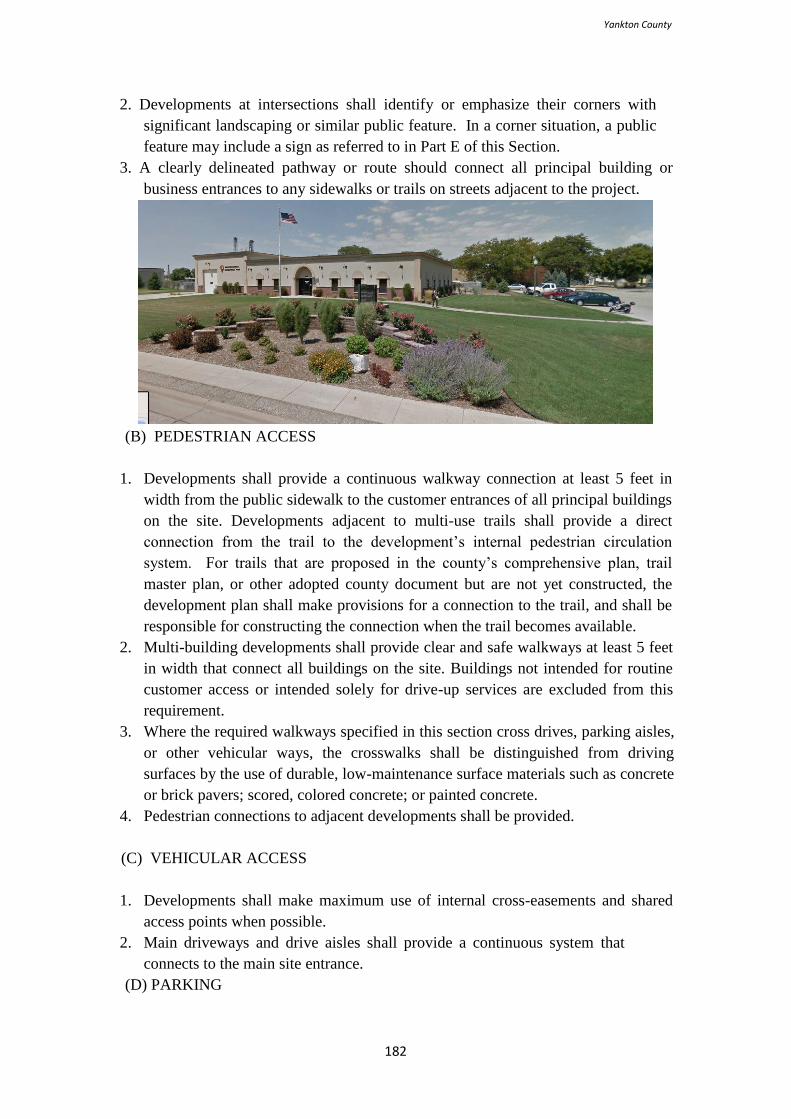
Yankton County
182
2. Developments at intersections shall identify or emphasize their corners with
significant landscaping or similar public feature. In a corner situation, a public
feature may include a sign as referred to in Part E of this Section.
3. A clearly delineated pathway or route should connect all principal building or
business entrances to any sidewalks or trails on streets adjacent to the project.
(B) PEDESTRIAN ACCESS
1. Developments shall provide a continuous walkway connection at least 5 feet in
width from the public sidewalk to the customer entrances of all principal buildings
on the site. Developments adjacent to multi-use trails shall provide a direct
connection from the trail to the development’s internal pedestrian circulation
system. For trails that are proposed in the county’s comprehensive plan, trail
master plan, or other adopted county document but are not yet constructed, the
development plan shall make provisions for a connection to the trail, and shall be
responsible for constructing the connection when the trail becomes available.
2. Multi-building developments shall provide clear and safe walkways at least 5 feet
in width that connect all buildings on the site. Buildings not intended for routine
customer access or intended solely for drive-up services are excluded from this
requirement.
3. Where the required walkways specified in this section cross drives, parking aisles,
or other vehicular ways, the crosswalks shall be distinguished from driving
surfaces by the use of durable, low-maintenance surface materials such as concrete
or brick pavers; scored, colored concrete; or painted concrete.
4. Pedestrian connections to adjacent developments shall be provided.
(C) VEHICULAR ACCESS
1. Developments shall make maximum use of internal cross-easements and shared
access points when possible.
2. Main driveways and drive aisles shall provide a continuous system that
connects to the main site entrance.
(D) PARKING
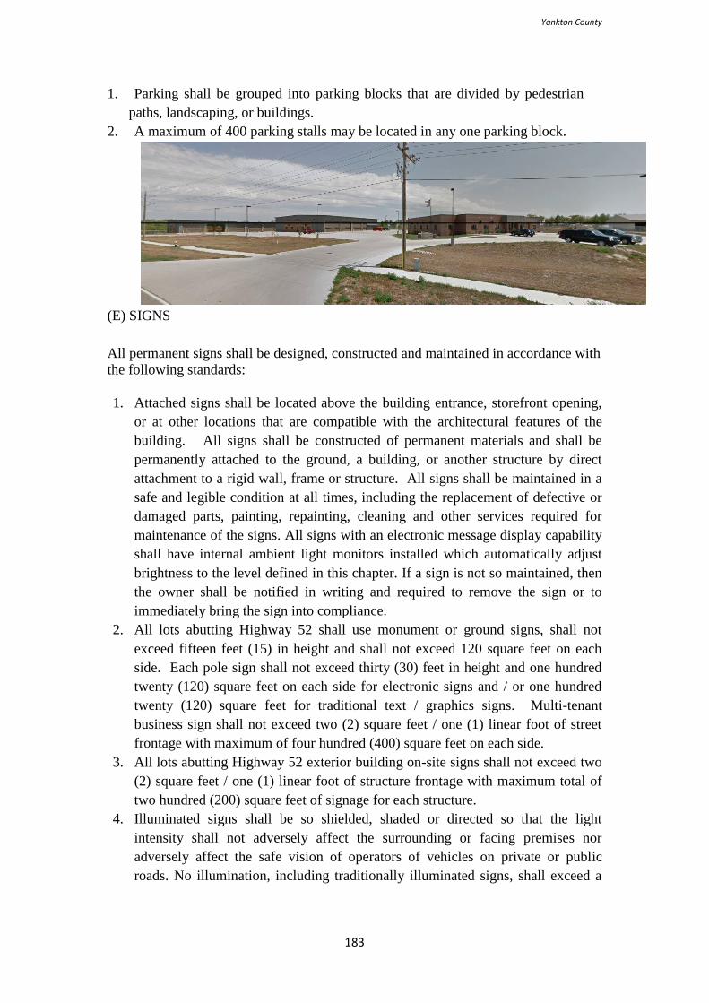
Yankton County
183
1. Parking shall be grouped into parking blocks that are divided by pedestrian
paths, landscaping, or buildings.
2. A maximum of 400 parking stalls may be located in any one parking block.
(E) SIGNS
All permanent signs shall be designed, constructed and maintained in accordance with
the following standards:
1. Attached signs shall be located above the building entrance, storefront opening,
or at other locations that are compatible with the architectural features of the
building. All signs shall be constructed of permanent materials and shall be
permanently attached to the ground, a building, or another structure by direct
attachment to a rigid wall, frame or structure. All signs shall be maintained in a
safe and legible condition at all times, including the replacement of defective or
damaged parts, painting, repainting, cleaning and other services required for
maintenance of the signs. All signs with an electronic message display capability
shall have internal ambient light monitors installed which automatically adjust
brightness to the level defined in this chapter. If a sign is not so maintained, then
the owner shall be notified in writing and required to remove the sign or to
immediately bring the sign into compliance.
2. All lots abutting Highway 52 shall use monument or ground signs, shall not
exceed fifteen feet (15) in height and shall not exceed 120 square feet on each
side. Each pole sign shall not exceed thirty (30) feet in height and one hundred
twenty (120) square feet on each side for electronic signs and / or one hundred
twenty (120) square feet for traditional text / graphics signs. Multi-tenant
business sign shall not exceed two (2) square feet / one (1) linear foot of street
frontage with maximum of four hundred (400) square feet on each side.
3. All lots abutting Highway 52 exterior building on-site signs shall not exceed two
(2) square feet / one (1) linear foot of structure frontage with maximum total of
two hundred (200) square feet of signage for each structure.
4. Illuminated signs shall be so shielded, shaded or directed so that the light
intensity shall not adversely affect the surrounding or facing premises nor
adversely affect the safe vision of operators of vehicles on private or public
roads. No illumination, including traditionally illuminated signs, shall exceed a
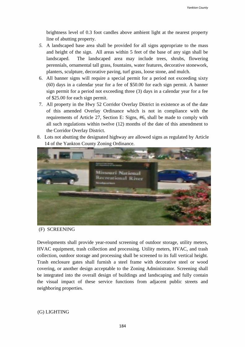
Yankton County
184
brightness level of 0.3 foot candles above ambient light at the nearest property
line of abutting property.
5. A landscaped base area shall be provided for all signs appropriate to the mass
and height of the sign. All areas within 5 feet of the base of any sign shall be
landscaped. The landscaped area may include trees, shrubs, flowering
perennials, ornamental tall grass, fountains, water features, decorative stonework,
planters, sculpture, decorative paving, turf grass, loose stone, and mulch.
6. All banner signs will require a special permit for a period not exceeding sixty
(60) days in a calendar year for a fee of $50.00 for each sign permit. A banner
sign permit for a period not exceeding three (3) days in a calendar year for a fee
of $25.00 for each sign permit.
7. All property in the Hwy 52 Corridor Overlay District in existence as of the date
of this amended Overlay Ordinance which is not in compliance with the
requirements of Article 27, Section E: Signs, #6, shall be made to comply with
all such regulations within twelve (12) months of the date of this amendment to
the Corridor Overlay District.
8. Lots not abutting the designated highway are allowed signs as regulated by Article
14 of the Yankton County Zoning Ordinance.
(F) SCREENING
Developments shall provide year-round screening of outdoor storage, utility meters,
HVAC equipment, trash collection and processing. Utility meters, HVAC, and trash
collection, outdoor storage and processing shall be screened to its full vertical height.
Trash enclosure gates shall furnish a steel frame with decorative steel or wood
covering, or another design acceptable to the Zoning Administrator. Screening shall
be integrated into the overall design of buildings and landscaping and fully contain
the visual impact of these service functions from adjacent public streets and
neighboring properties.
(G) LIGHTING
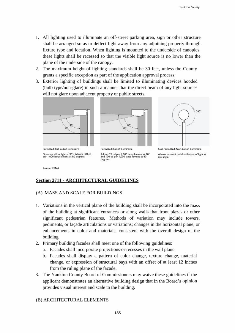
Yankton County
185
1. All lighting used to illuminate an off-street parking area, sign or other structure
shall be arranged so as to deflect light away from any adjoining property through
fixture type and location. When lighting is mounted to the underside of canopies,
these lights shall be recessed so that the visible light source is no lower than the
plane of the underside of the canopy.
2. The maximum height of lighting standards shall be 30 feet, unless the County
grants a specific exception as part of the application approval process.
3. Exterior lighting of buildings shall be limited to illuminating devices hooded
(bulb type/non-glare) in such a manner that the direct beam of any light sources
will not glare upon adjacent property or public streets.
Section 2711 - ARCHITECTURAL GUIDELINES
(A) MASS AND SCALE FOR BUILDINGS
1. Variations in the vertical plane of the building shall be incorporated into the mass
of the building at significant entrances or along walls that front plazas or other
significant pedestrian features. Methods of variation may include towers,
pediments, or façade articulations or variations; changes in the horizontal plane; or
enhancements in color and materials, consistent with the overall design of the
building.
2. Primary building facades shall meet one of the following guidelines:
a. Facades shall incorporate projections or recesses in the wall plane.
b. Facades shall display a pattern of color change, texture change, material
change, or expression of structural bays with an offset of at least 12 inches
from the ruling plane of the facade.
3. The Yankton County Board of Commissioners may waive these guidelines if the
applicant demonstrates an alternative building design that in the Board’s opinion
provides visual interest and scale to the building.
(B) ARCHITECTURAL ELEMENTS
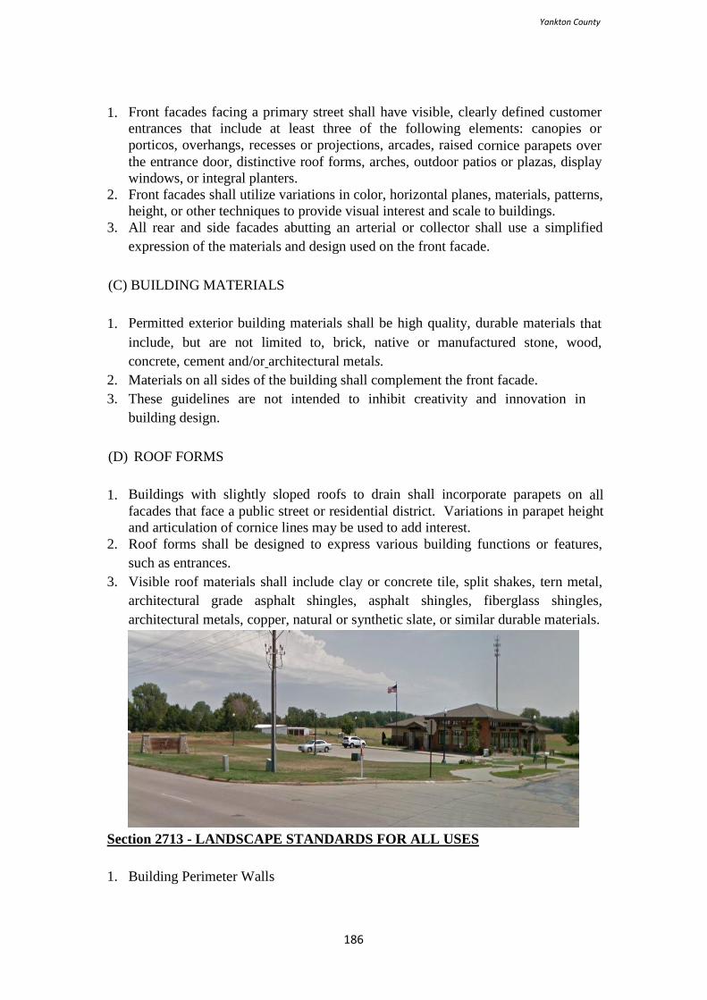
Yankton County
186
1. Front facades facing a primary street shall have visible, clearly defined customer
entrances that include at least three of the following elements: canopies or
porticos, overhangs, recesses or projections, arcades, raised cornice parapets over
the entrance door, distinctive roof forms, arches, outdoor patios or plazas, display
windows, or integral planters.
2. Front facades shall utilize variations in color, horizontal planes, materials, patterns,
height, or other techniques to provide visual interest and scale to buildings.
3. All rear and side facades abutting an arterial or collector shall use a simplified
expression of the materials and design used on the front facade.
(C) BUILDING MATERIALS
1. Permitted exterior building materials shall be high quality, durable materials that
include, but are not limited to, brick, native or manufactured stone, wood,
concrete, cement and/or architectural metals.
2. Materials on all sides of the building shall complement the front facade.
3. These guidelines are not intended to inhibit creativity and innovation in
building design.
(D) ROOF FORMS
1. Buildings with slightly sloped roofs to drain shall incorporate parapets on all
facades that face a public street or residential district. Variations in parapet height
and articulation of cornice lines may be used to add interest.
2. Roof forms shall be designed to express various building functions or features,
such as entrances.
3. Visible roof materials shall include clay or concrete tile, split shakes, tern metal,
architectural grade asphalt shingles, asphalt shingles, fiberglass shingles,
architectural metals, copper, natural or synthetic slate, or similar durable materials.
Section 2713 - LANDSCAPE STANDARDS FOR ALL USES
1. Building Perimeter Walls
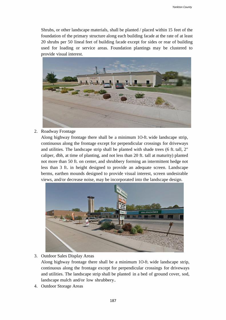
Yankton County
187
Shrubs, or other landscape materials, shall be planted / placed within 15 feet of the
foundation of the primary structure along each building facade at the rate of at least
20 shrubs per 50 lineal feet of building facade except for sides or rear of building
used for loading or service areas. Foundation plantings may be clustered to
provide visual interest.
2. Roadway Frontage
Along highway frontage there shall be a minimum 1O-ft. wide landscape strip,
continuous along the frontage except for perpendicular crossings for driveways
and utilities. The landscape strip shall be planted with shade trees (6 ft. tall, 2"
caliper, dbh, at time of planting, and not less than 20 ft. tall at maturity) planted
not more than 50 ft. on center, and shrubbery forming an intermittent hedge not
less than 3 ft. in height designed to provide an adequate screen. Landscape
berms, earthen mounds designed to provide visual interest, screen undesirable
views, and/or decrease noise, may be incorporated into the landscape design.
3. Outdoor Sales Display Areas
Along highway frontage there shall be a minimum 1O-ft. wide landscape strip,
continuous along the frontage except for perpendicular crossings for driveways
and utilities. The landscape strip shall be planted in a bed of ground cover, sod,
landscape mulch and/or low shrubbery.
4. Outdoor Storage Areas
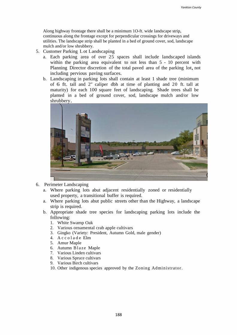
Yankton County
188
Along highway frontage there shall be a minimum 1O-ft. wide landscape strip,
continuous along the frontage except for perpendicular crossings for driveways and
utilities. The landscape strip shall be planted in a bed of ground cover, sod, landscape
mulch and/or low shrubbery.
5. Customer Parking L ot Landscaping
a. Each parking area of over 25 spaces shall include landscaped islands
within the parking area equivalent to not less than 5 - 10 percent with
Planning Director discretion of the total paved area of the parking lot, not
including pervious paving surfaces.
b. Landscaping in parking lots shall contain at least 1 shade tree (minimum
of 6 ft. tall and 2" caliper dbh at time of planting and 20 ft. tall at
maturity) for each 100 square feet of landscaping. Shade trees shall be
planted in a bed of ground cover, sod, landscape mulch and/or low
shrubbery.
6. Perimeter Landscaping
a. Where parking lots abut adjacent residentially zoned or residentially
used property, a transitional buffer is required.
a. Where parking lots abut public streets other than the Highway, a landscape
strip is required.
b. Appropriate shade tree species for landscaping parking lots include the
following: 1. White Swamp Oak
2. Various ornamental crab apple cultivars
3. Gingko (Variety: President, Autumn Gold, male gender)
4. A c c o l a d e Elm
5. Amur Maple
6. Autumn B l a ze Maple
7. Various Linden cultivars
8. Various Spruce cultivars
9. Various Birch cultivars
10. Other indigenous species approved by the Zoning Administrator .

Yankton County
189
THIS PAGE RESERVED FOR FUTURE USE
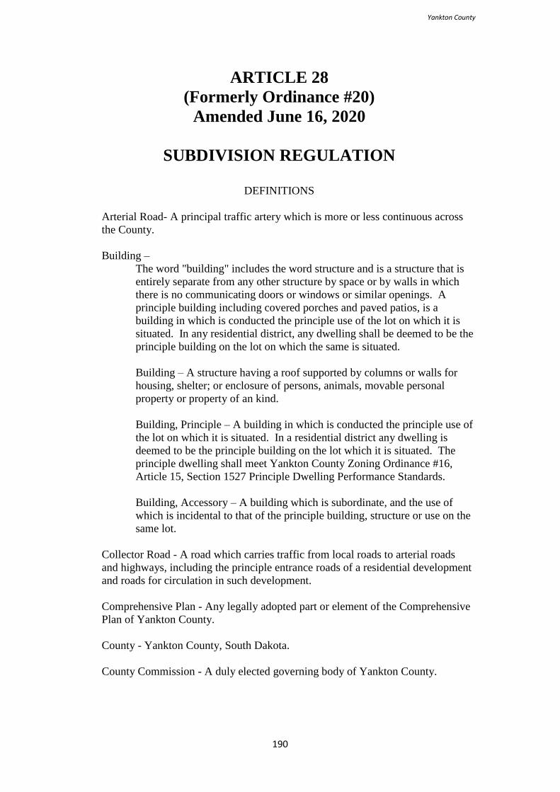
Yankton County
190
ARTICLE 28
(Formerly Ordinance #20)
Amended June 16, 2020
SUBDIVISION REGULATION
DEFINITIONS
Arterial Road- A principal traffic artery which is more or less continuous across
the County.
Building –
The word "building" includes the word structure and is a structure that is
entirely separate from any other structure by space or by walls in which
there is no communicating doors or windows or similar openings. A
principle building including covered porches and paved patios, is a
building in which is conducted the principle use of the lot on which it is
situated. In any residential district, any dwelling shall be deemed to be the
principle building on the lot on which the same is situated.
Building – A structure having a roof supported by columns or walls for
housing, shelter; or enclosure of persons, animals, movable personal
property or property of an kind.
Building, Principle – A building in which is conducted the principle use of
the lot on which it is situated. In a residential district any dwelling is
deemed to be the principle building on the lot which it is situated. The
principle dwelling shall meet Yankton County Zoning Ordinance #16,
Article 15, Section 1527 Principle Dwelling Performance Standards.
Building, Accessory – A building which is subordinate, and the use of
which is incidental to that of the principle building, structure or use on the
same lot.
Collector Road - A road which carries traffic from local roads to arterial roads
and highways, including the principle entrance roads of a residential development
and roads for circulation in such development.
Comprehensive Plan - Any legally adopted part or element of the Comprehensive
Plan of Yankton County.
County - Yankton County, South Dakota.
County Commission - A duly elected governing body of Yankton County.
Yankton County
191
Cul-de-sac Road- A local right-of-way with only one outlet that terminates in a
vehicular turnaround and having an appropriate terminal for the safe and
convenient reversal of traffic turnaround.
Publically Dedicated Property- A grant of land deeded to the public for their
perpetual use.
Developer - The owner of the property being platted or replatted or the person
designated by the owner as being responsible for the development of the property.
The terms “subdivider” and “developer” are synonymous and used
interchangeably, and shall include any person, partnership, firm, association,
corporation and/or any officer, agent, employee and trustee thereof who does or
participates in the doing of any act toward the subdivision of land within the
intent, scope and purview of this Ordinance. The developer shall also be defined
as the builder or contractor if they are responsible for the construction of
buildings and/or structures or permanent improvements.
Double Frontage Lot- A lot which abuts a road on two opposite sides (not a
corner lot).
Easement - Authorization by a property owner for the use by another, and for a
specified purpose, of any designated part of their property. For the purposes of
this Ordinance the term shall primarily be used to describe utility access.
Final Subdivision Plan - The plan shall include final drainage and grading plans
and an erosion control plan.
Frontage Road - A road generally located adjacent and parallel to an arterial road,
used only for access to abutting property providing limited access to the arterial
road.
Highway Superintendent - The person appointed by the County Commission to
direct the operations of the County Highway Department.
Local Road - A road intended to provide access to arterial and collector roads
from individual properties in a subdivision and to provide right-of-way for
various utilities but not intended to be used for through traffic.
Lot - A lot is a parcel of land of at least sufficient size to meet minimum zoning
requirements for use, coverage, and area, and including such yards and other open
spaces as are herein required. Such parcel shall have frontage on an improved
public right-of-way, or approved private right-of-way, and may consist of a single
lot of record; a portion of a lot of record; a combination of complete lots of
record, of complete lots of record and portions of lots of record; in no case of
division or combination shall any residual lot or parcel be created which does not
meet the requirements of this ordinance, unless approved by the County
Commission.
Major Road Plan - The transportation plan adopted as part of the Comprehensive
Plan by the County Commission.
Yankton County
192
Monument - A boundary marker of concrete, enduring stone or material,
permanently planted and firmly fixed in the ground placed so that the top of the
monument is flush with natural ground. The monument shall meet current
professional survey standards.
Planning Commission - The Yankton County Planning Commission, a body of
persons having the power to hear and make recommendations to the Board of
Adjustment or County Commission, based on Findings of Fact, in accordance
with provisions of the Subdivision Ordinance, on requests for conditional use
permit, variance, amendment or change in zoning. The term Planning
Commission shall be synonymous with Planning and Zoning Commission and
Commission, but shall not include Board of Adjustment or Zoning Board.
Plat - A map, or representation on paper, depicting a piece of land subdivided into
lots, parcels, tracts or blocks, including roads, right of ways, commons, and
public grounds, if any, all drawn to scale and complete and showing all
irrevocable offers of dedication.
Preliminary Plan – A map depiction consisting of the preliminary subdivision
plan, and showing the preliminary drainage and grading plan.
Preliminary Subdivision Plan – Maps, drawings and /or writings indicating the
proposed layout of the lots, blocks, and public rights-of- way within a
subdivision.
Private Roadway – An access that has not been dedicated, but rather reserved as
private access to property. The access shall be owned and maintained by the
property owners which it serves, and shall be the full width of the easement
including the driving surface and ditches.
Replat - A map depiction changing an approved or recorded subdivision plat
which affects any road layout, area reserved for public use, or lot line.
Right-of-Way; ROW - An area of land that is legally described in a registered
deed. The term right-of-way shall include any defined access route or point
including but not limited to public and private accesses, road easements, streets,
roads, and drives other than a private drive serving a single owner.
Structure –
Anything constructed or erected which requires location on the ground, or
attached to something having a fixed location on the ground. Among other
things, structures include, but are not limited to, buildings and
manufactured homes. This definition does not include semi-portable
agricultural structures.
Anything manufactured or constructed by humans, as opposed to that
occurring in nature, which is affixed, anchored, or otherwise attached to or
below surface of the ground.
Yankton County
193
Anything manufactured or constructed by humans, as opposed to that
occurring in nature, which is attached, to something else having been
affixed, anchored, or otherwise attached to or below the surface of the
ground.
Structure, Accessory – A structure which is subordinate to a principle
building and the use of which is incidental to that of the principle use on
the same lot.
Subdivision - The division of a parcel of land into more than two (2) lots; or
parcels less than twenty (20) acres in size platted for the purpose of transfer of
ownership, or building development, whether future or immediate; or any
division of land involving a new road regardless of parcel size or the number of
parcels. (SDCL 11-3-8)
Unconventional Septic Systems – All septic systems which are not defined as
“On-site wastewater system – a system designed to contain, distribute, or treat
wastewater on or near the location where the wastewater is generated, including
sewers, septic tanks and absorption fields”.
Zoning Administrator - An official of the County, hired by the Yankton County
Commission, to administer and enforce the Subdivision Regulations and other
provisions of the Yankton County Zoning Ordinance. This official may be given
administrative authority to approve future plats in a subdivision after a final
subdivision plan has been approved by the Yankton County Board of Adjustment
or Yankton County Commission.
GENERAL PROVISIONS
Section 2801 Title (Amended June 16, 2020)
These regulations shall be referred to as the Subdivision Regulation Ordinance of
Yankton County, South Dakota.
Section 2802 Purpose (Amended June 16, 2020)
It is the purpose of this ordinance to regulate the subdivision of land so as to provide
coordination of roads with other subdivisions and transportation plans; to set aside
adequate areas for public uses, water and sanitation facilities, drainage and flood
control; to foster efficient and orderly growth compatible with the natural
environment; to prevent unauthorized land subdivision; to protect and provide for the
public health, safety, and general welfare of the County; and to conform with the
comprehensive plan.
Yankton County
194
Section 2803 Jurisdiction (Amended June 16, 2020)
A) These subdivision regulations shall apply to all subdivisions of land, as
described herein, located within the unincorporated area of the county.
B) It shall be unlawful for any person having control of any land within the
jurisdiction of the County to subdivide or lay-out such land in lots less than
twenty (20) acres, unless by plat, in accordance with the laws of the State of
South Dakota and the regulations contained herein.
C) No land shall be subdivided until the owner or developer has submitted the
preliminary plan, if required, to the Planning Commission for its approval.
D) No plat shall be recorded in the office of the Register of Deeds and no lots
shall be sold from such plat unless and until approved as herein provided.
The Register of Deeds shall not record any document of any sale or transfer
of unplatted property except in accordance with this ordinance.
Section 2804 Conformity With Other Plans (Amended June 16, 2020)
In addition to the requirements established herein, all subdivision plans and plats
shall comply with the following laws, rules, and regulations:
A) The Comprehensive Plan for the County and the policies set forth therein.
B) The Zoning Ordinance of the County.
C) Other plans which may be or have been adopted that would affect the
subdivision and use of the land. An example is the Flood Damage Prevention
ordinance.
Section 2805 Interpretation, Abrogation and Severability (Amended June 16, 2020)
A) In interpreting and applying the provisions of this Ordinance, these
regulations are the minimum requirements for the promotion of public
safety, health, and general welfare. It is not the intent of this Ordinance to
uphold, repeal, abrogate or impair any existing easement, covenant, or deed
restriction, or non-conforming lots of record at the effective date of adoption
or amendment of the Subdivision Ordinance, where these provisions
conflict or overlap.
B) Should any provision of this ordinance be declared invalid by a court of
competent jurisdiction, such decision shall not affect the validity of the
ordinance as a whole or any portion thereof.
Section 2806 Amendments (Amended June 16, 2020)
For the purpose of providing for the health, safety and general welfare of the
community, the County Commission may from time to time amend the provisions
imposed by these subdivision regulations.(SDCL 11-2-30) Public hearings on all
Yankton County
195
proposed amendments shall be held by the Planning Commission and the County
Commission in the manner prescribed by law. (SDCL 11-2-18)
Section 2807 Fees (Amended June 16, 2020)
A) The developer shall pay to the Planning Department a fee as set by the County
Commission for the final subdivision plan, including all plats to be filed with
the Register of Deeds at this approval period. All additional plats submitted
after the initial final subdivision plan shall pay a fee as set by the County
Commission for each plat shown on the final subdivision plan. Prior to
release of the plat, the developer shall also pay for the cost of all road signs
as specified in Section 2826 (C). (Amended June 16, 2020)
B) A fee as set by the County Commission shall be charged for the filing of a
subdivision variance. (Amended June 16, 2020)
ENFORCEMENT
Section 2808 Powers and Duties (Amended June 16, 2020)
A) The Zoning Administrator is hereby authorized to administer and enforce this
ordinance. Any appropriate actions may be taken by law or in equity to
prevent any violation of this ordinance, to prevent unlawful construction, to
recover damages, to correct or abate a violation, or to prevent illegal
occupancy of a building, structure, or premises. These remedies shall be in
addition to the penalties described below.
B) In their interpretation and application, the provisions of this ordinance shall be
held to be the minimum requirements for the promotion of the public health,
safety, and general welfare.
Section 2809 Variations and Exceptions (Amended June 16, 2020)
Whenever the tract to be subdivided is of such unusual size or shape, or is surrounded
by such development or unusual conditions that the strict application of this
ordinance would result in real difficulties or substantial hardship or injustice, the
Planning Commission, after a report detailing the exception or variance by the
Zoning Administrator, may recommend and the County Commission may approve
modifications in the requirements so that the developer may develop the property in a
reasonable manner, but so that, at the same time, the public welfare and interests of
the County are protected and the general intent and spirit of this ordinance are
preserved.
Section 2810 Violations (Amended June 16, 2020)
A) No person, firm, or corporation shall transfer or sell any parcel either by
reference to, exhibition of, or by the use of a final subdivision plan before
such lot or subdivision has been approved by the County in accordance with
this ordinance and has been filed with the County Register of Deeds.
Yankton County
196
B) The subdivision of any lot or any parcel of land, by the metes and bounds
description for the purpose of sale (pursuant to SDCL 43-21-1), transfer or
lease, with the intent of evading the terms of this ordinance shall not be
permitted.
C) No zoning or building permit shall be issued for the construction of any
building or structure located on a lot or plat subdivided or sold in violation of
the provisions of this ordinance.
Section 2811 Penalties (Amended June 16, 2020)
Any person, firm, or corporation violating the provisions of this ordinance shall be
guilty of a Class 2 Misdemeanor and shall be punished pursuant to SDCL 7-18A-2.
Each and every day that the violation continues may constitute a separate offense.
SUBDIVISION PLANS IN GENERAL
Section 2812 Plat Required (Amended June 16, 2020)
Whenever any subdivision of land into a lot or lots less than twenty (20) acres is
proposed, before any contract is made for the sale of any part thereof, and before any
permit for the erection of a structure in such proposed subdivision shall be granted,
the developer, owner, or authorized agent shall apply for and secure approval of such
proposed subdivision in accordance with the procedures set forth below.
Section 2813 Recording, Use and Selling (Amended June 16, 2020)
A) No plat of any subdivision shall be allowed to be recorded with the Register of
Deeds or have any validity until it has been approved in the manner prescribed
by this ordinance. If any such unapproved plat is recorded, it is invalid and the
County Commission shall institute proceedings to have the plat stricken from the
records.
B) No owner, or agent of the owner, of any land located within a subdivision shall
transfer or sell any land by reference to, exhibition of, or by the use of a
subdivision plan before a plat of said land has been approved and recorded in the
manner prescribed herein.
C) No local agency shall issue any permit or grant any approval necessary to
develop any real property which has been divided, or which has resulted from a
division, in violation of the provisions of this Ordinance if it is found that such
real property is contrary to the public health, safety, or welfare. The authority to
deny such a permit shall apply whether the applicant was the owner of record at
the time of such violation or whether the applicant is the current owner of record
or a vendee of the current owner pursuant to a contract of sale with, or without,
actual or constructive knowledge of the violations at the time of acquisition of
his interest in said real property.
Section 2814 Plat Approval Process (Amended June 16, 2020)
Yankton County
197
All proposed subdivision plats must be approved. (Amended June 16, 2020)
A) Preliminary and Final Plats/Plans - The final plan shall consist of the
proposed plat, Latitude/Longitude on a minimum of two connections to roads
or section lines, an electronic submittal of the plat in either AutoCAD (dwg
format) or an ESRI (Shapefile format), the final drainage and grading plan,
and the final erosion control plan. The plat shall provide the information
indicated in Section 2820 and shall require the approval of the Planning
Commission and County Commission. (Amended June 16, 2020)
Flood Designated Areas. When located within flood prone areas as designated
on the Flood Insurance Rate Map (FIRM), all subdivision proposals:
1. Shall be consistent with the need to minimize flood damage;
2. Shall have public utilities and facilities such as sewer, gas, electrical, and
water systems located and constructed to minimize flood damage;
3. Shall have adequate drainage provided to reduce exposure to flood damage
and shall not put
additional burden on adjacent land owners; and
4. Shall provide base flood elevation data for subdivision proposals and other
proposed development which contain at least fifty (50) lots or five (5) acres
(whichever is less). (Amended June 16, 2020)
Replats
If the land proposed for platting is a resubdivision, it shall require a preliminary plan
and a plat of the resubdivision, requiring the same review and approval procedures as
the preliminary plan and the plat. The Zoning Administrator may waive the
requirements for a preliminary plan. (Amended June 16, 2020)
Filing Fee
The developer shall pay to the Planning Department a fee as set by the County
Commission for the final subdivision plan, including all plats to be filed with the
Register of Deeds at this approval period. All additional plats submitted after the
initial final subdivision plan shall pay a fee as set by the County Commission for each
plat shown on the final subdivision plan. Prior to release of the plat, the developer
shall also pay for the cost of all road signs as specified in Section 2826 (C).
(Amended June 16, 2020)
PRELIMINARY PLAN
Section 2815 Information Required (Amended June 16, 2020)
Whenever a preliminary plan is proposed, the developer shall submit a plan at
standard, defined scale no smaller than 8 ½” X 11” and no larger than 15” X 26”.
The preliminary plan shall be submitted to the Planning Department and shall contain
the following:
Yankton County
198
A) Preliminary Subdivision Plan
1) The name of the proposed subdivision and location by quarter section,
section, township and range. Subdivision names shall not duplicate,
be the same spelling, or alike in pronunciation with any existing
subdivision located in the same section, unless it is an extension of or
adjoining an existing subdivision. All subdivision names shall be
subject to approval by the Zoning Administrator.
2) The names of all adjacent subdivisions and their platting pattern.
Adjoining unplatted land shall be labeled as such.
3) The correct legal description. Notations stating acreage, scale, and
north arrow.
4) The owner, developer, and surveyor's names and telephone numbers.
5) Vicinity map, showing locations of the preliminary plan and
surrounding property.
6) Exterior boundaries of the proposed subdivision referenced to a corner
marker of the U.S. Public Land Survey, corner marker of adjacent
subdivision or existing survey plat and the total acreage encompassed
thereby.
7) The location and width of all proposed and existing road rights-of-
way, existing structures, easements, railroad rights-of-way, standard
survey notations, topography and aerial maps/photographs.
8) Existing contours at vertical intervals not greater than ten feet. A
lesser interval may be required in those cases where the character or
topography of the land is difficult to determine.
9) A systematic lot and block numbering pattern, lot lines and road
names.
10) The dimensions and acreage of all lots.
11) Latitude/Longitude on a minimum of two connections to roads or
section lines, an electronic submittal of the plat in either AutoCAD
(dwg format) or an ESRI (Shapefile format) (Amended June 16,
2020)
B) Other Preliminary Plans.
Generally, the following plans shall be submitted in conjunction with the
preliminary plan:

Yankton County
199
1) Preliminary Drainage and Grading. The existing drainage pattern for
the area should be generally shown along with any proposed cut and
fill operations which would alter the existing drainage patterns.
2) Erosion Control. In any proposed subdivision in which an area greater
than five acres will be disturbed, or in areas where topographic
features are such that erosion, siltation or temporary runoff problems
may occur, a site plan shall be required showing how these problems
will be resolved.
3) Wastewater and Septic System. All unconventional septic systems
will provide specific details as required by South Dakota Codified
Law (chapter 34A-2) and South Dakota Administrative Rules (chapter
74:53:01).
Section 2816 Approval of Preliminary Plan (Amended June 16, 2020)
After the preliminary plan has been recommended for approval or disapproval by the
Planning Commission, it shall be kept on file in the office of the Zoning
Administrator. Approval of the preliminary plan shall indicate approval of the
development concept only, and it does not constitute an acceptance or approval of the
subdivision plan; therefore, no zoning or building permits shall be issued based on
the approval of the preliminary plan.
Section 2817 Effective Period of Preliminary Approval (Amended June 16, 2020)
The approval of a preliminary plan shall be effective for a period of 18 months with a
single extension of 18 months, at the end of which time approval of the subdivision
plat or a portion thereof must have been obtained from the County Commission. Any
plan which has not received approval for all or a portion of it within the period of
time set forth herein, shall be null and void, and the developer shall be required to
resubmit a new plan for preliminary approval subject to any new subdivision
regulations.
Section 2818 Revisions to Preliminary Plan (Amended June 16, 2020)
Minor amendments to an approved preliminary plan may be made at the discretion of
the Zoning Administrator and Highway Superintendent.
FINAL PLANS AND THE PLAT
Section 2819 Final Plans (Amended June 16, 2020)
Following the approval of the Preliminary Plan, if the developer wishes to proceed,
final drainage, grading and erosion control plans shall be submitted to the Zoning
Administrator and Highway Superintendent for review and approval. Any or all of
these plans may be deleted at the Zoning Administrator's discretion.
Yankton County
200
Section 2820 The Plat (Amended June 16, 2020)
Two copies and one reproducible Mylar of the plat shall be submitted to the Zoning
Administrator for review and approval. If the plat is not approved by the Zoning
Administrator within ten (10) days of submittal, the plat shall be presented to the
County Commission for action. The plat should be drawn at a scale of 100 feet to an
inch from an accurate survey and on one or more sheets whose dimensions are as
required by State Law. If more than two sheets are required, an index sheet of the
same dimension shall be attached and filed. Plats which describe large agricultural
tracts may be drawn at a scale of 200, 300, 400 or 600 feet to the inch. The plat shall
contain the following information:
A) The name of the proposed subdivision and location by quarter section,
section, township and range. Each plat shall be titled as follows: (Name)
Addition in the quarter, Section , T N, R W of the 5th P.M.,
Yankton County, South Dakota.
B) Scale and north arrow.
C) The names of all adjacent subdivisions, all lot and block lines, type of
easements, and rights- of-way.
D) A systematic lot and block numbering pattern, lot lines and road names, and
the square footage or acreage of all lots.
E) The location and width of all proposed and existing rights-of-way, easements
and private roadways.
F) The boundary lines of the area being subdivided with accurate angles or
bearings and distances tying the perimeter boundaries to the nearest section
corner, other previously described subdivision, or other recognized permanent
monuments which shall be accurately described on the plat.
G) Location of all monuments and permanent control points, and all survey pins,
either set or located.
H) The location and description of any portions of the property intended to be
dedicated or granted for public use.
I) All dimensions, linear and angular, necessary for locating the boundaries of
the subdivision lots, roads, easements and type of easement, and any other
areas for public or private use. Linear dimensions are to be given to the
nearest 1/100 of a foot.
J) The radii, chords, length of curve, points of tangency, and central angles for all
curvilinear roads and radii for rounded corners.
K) Acknowledgment of the owner or owners of the plat of any restrictions,
including dedication of all public roads, alleys, parks, or other open spaces
shown thereon and the granting of easements required.
Yankton County
201
L) All formal irrevocable offers of dedication for all public roads and other uses
as required.
M) Certificates as specified in Article 11.
N) Latitude/Longitude on a minimum of two connections to roads or section
lines, an electronic submittal of the plat in either AutoCAD (dwg format) or
an ESRI (Shapefile format) (Amended June 16, 2020)
Section 2821 Road Names (Amended June 16, 2020)
A) Roads obviously in alignment with existing roads shall bear the names of
those roads.
B) Provisions:
No road names shall be used which duplicate, be the same in spelling or alike
in pronunciation with any other existing roads. Road names shall not exceed
12 letters, including spaces. Road name suffixes shall be applied as follows:
Street - a road running east and west
Avenue - a road running north and south
Road - a road running east and west or north and south but which is not
appropriate to name as a street or avenue
Lane - a road running northeast to southwest
Drive - a road running northwest to southeast
Trail - a road which wanders in different directions
Circle - all cul-de-sacs
Court - a road with two openings which enters and exits on the same road
Place - all private roads
REPLATS AND PLAT VACATIONS
Section 2822 Replats (Amended June 16, 2020)
If the land proposed for platting is a resubdivision, it shall require a final plan of the
subdivision, requiring the same review and approval procedures, including the fees,
as the original final plans. However, if the resubdivision meets the following
requirements, then it may be submitted as a plat. (Amended June 16, 2020)
Yankton County
202
A) The perimeter of the tract being replatted shall not be altered by the replat.
B) The previous platting lines shall be shown on the plat.
C) Latitude/Longitude on a minimum of two connections to roads or section
lines, an electronic submittal of the plat in either AutoCAD (dwg format) or
an ESRI (Shapefile format). (Amended June 16, 2020)
Section 2823 Vacation of Plats (Amended June 16, 2020)
Any plat or any part of a plat intended to be vacated shall be governed by the
requirements of SDCL11-3.
LOTS AND BLOCKS
Section 2824 Blocks (Amended June 16, 2020)
A) The length, width, and shape of blocks shall be determined with regard to:
1) Provision of adequate building sites suitable to the special needs of the type
of use contemplated.
2) The need for convenient access, circulation, and safety of traffic.
3) Topographic conditions.
B) Block lengths shall generally not exceed 1300 feet in length and shall be
normally wide enough to provide for two tiers of lots of an appropriate depth.
Section 2825 Lots (Amended June 16, 2020)
A) Lot arrangement shall be such that there will be no foreseeable difficulties, for
reasons of topography or other conditions, in securing permits to build on all lots
in compliance with the zoning regulations.
B) The minimum lot width required by the zoning regulations shall be measured
along the building setback line.
C) Corner lots for residential use shall have extra width to permit adequate building
setbacks from both roads.
D) All interior lot lines should be a straight line or a series of straight lines. Curved
interior lot lines may be allowed where topography, waterways or other
circumstances require curved lot lines.
E) Side lot lines may be at right angles to roads except on curves where they are
Yankton County
203
radial, or when otherwise approved.
F) Double frontage and reverse frontage lots shall be avoided except where essential
to separate a development from traffic arteries, or to overcome specific
disadvantages of topography and orientation. Driveways for such lots shall have
access only to an interior subdivision road. Where double frontage lots are used,
an extra lot depth or width shall be required to provide for an extra setback to
offset the impact of higher traffic volumes.
G) Plats for residential development adjacent to functioning railroad rights-of-way
shall provide additional lot depth or width to provide for sufficient setback to
offset the impact of the railroad traffic.
H) Each lot shall abut a dedicated public right-of-way, approved private roadway or
have an appropriate easement to a public road.
I) Minimum lot size required by the zoning regulations shall not include any public
right-of-way.
MINIMUM ROAD IMPROVEMENTS AND DESIGN STANDARDS
Section 2826 Arrangement and Design (Amended June 16, 2020)
A) Roads shall be related appropriately to the topography.
B) All new subdivision roads shall be properly integrated with the existing system of
roads. There should be a road connecting adjacent subdivisions where
topographical and land use considerations permit.
C) In order to maintain consistent signage throughout the County, it shall be the
County's responsibility to erect road signs at all road intersections, both public
and private, within the new subdivision. The owner or developer shall pay the
County for all material and installation costs as determined by the Highway
Superintendent.
D) Proposed collector roads shall be extended to the boundary lines of the tract to be
subdivided, unless prevented by topography or other physical conditions.
E) The arrangement of all collector roads shall be such as not to cause hardship to
adjoining landowners when they plat their own land and seek access to the roads.
F) All subdivision roads shall be permanently dedicated as public rights-of-way or
shown as private roadways. For the dedication of public right-of-way, the plat
shall include a certificate for township acceptance of the road dedication. An
owner’s certificate shall describe the legal responsibilities for construction, repair
and maintenance of said roads and be filed with the final subdivision plan with
the Yankton County Planning Department (see Section 2836). (Amended June
16, 2020)
Yankton County
204
G) When the traffic impact of one or more proposed property developments
indicates that the public safety can be better served by the use of access
easements, the following requirements shall apply:
1) The access easement shall provide for perpetual unobstructed access to the
area it serves, and prohibit the erection of any structure within or adjacent
to the access area which would interfere with the use of the access
easement by the public or any governmental agency.
2) Access easements shall be indicated on the plat.
3) Any plat which shows an access easement as a means of access shall
provide language in the owner’s certificate (see Section 2836) reserving
the easement area for perpetual unobstructed access. (Amended June 16,
2020)
Section 2827 Minimum Road Right-of-Way (Amended June 16, 2020)
A) Roads shall have a minimum publicly dedicated right-of-way of 66 feet. An
easement of 46 feet shall be reserved for private roadways. A maximum
right-of-way of 100 feet may be required on roads designated as arterial and
collector.
B) Cul-de-sacs will be required where, due to physical constraints, they are
necessary for the reasonable development of the subdivision. The minimum
radius of a turnaround at the end of a cul-de-sac shall be within the 66 feet
right of way. This shall also apply to private roadways with the minimum
radius of a turnaround at the end of a cul-de-sac within the 46 feet right of
way.
Section 2828 Subdivision Road Standards (Amended June 16, 2020)
A) Access from individual lots within a subdivision onto an arterial road shall be
prohibited. Frontage roads are not encouraged but may be considered when
special circumstances exist.
B) Driveway spacing and sight distance requirements shall be in accordance with
SDDOT standards.
C) Minimum width of the driving surface shall be 24 feet. Ditches and
driveways shall have a maximum inslope of 4:1 in accordance with
specifications of the Yankton County Highway Department.
D) The subdivision roads may have a gravel driving surface. The subdivision
roads shall be constructed in accordance with the specifications of the
Yankton County Highway Department.
E) Gravel roads shall have an initial three inch lift of gravel spread over the
driving surface. This lift shall be allowed to settle over one winter season. A
second three inch lift of gravel shall be spread over the driving surface within
Yankton County
205
one year of the first lift. Asphalt and Portland cement concrete surfaces shall
be constructed in accordance with specifications of the Yankton County
Highway Department.
F) Culverts under roadways shall be R.C.P. Culverts under driveways shall be
either R.C.P. or C.M.P. All culverts shall be in accordance with the
specifications of the Yankton County Highway Department.
G) The minimum culvert diameter shall be 12 inches.
H) A cross slope (crown) shall be provided on all roads at a rate of .02 feet per
foot.
I) The road ditch shall be constructed in accordance with the specifications of
the Yankton County Highway Department.
J) Seeding of ditches and other erosion protection measures shall be employed
after grading is completed to minimize erosion.
Section 2829 Private Roadways (Amended June 16, 2020)
A) Private roadways shall be indicated on the plat.
B) Any private roadway approved by the County shall provide permanent
unobstructed access to the area it serves. The erecting of any structure within
the private roadway easement which would in any way interfere with the use
of such private roadway by the public or any governmental agency will not be
permitted.
C) The Owner's Certificate in accordance with Section 2836 shall reserve the
private road for permanent unobstructed access to abutting property and
establishing private responsibility for maintenance of the roads. (Amended
June 16, 2020)
D) All road standards specified in Section 2836 shall also apply to private
roadways constructed in accordance with the specifications of the Yankton
County Highway Department. (Amended June 16, 2020)
Section 2830 Intersections (Amended June 16, 2020)
A) Acute angles at road intersections are to be avoided in so far as possible, but
in no case will an angle of less than 80 degrees be permitted.
B) Not more than two roads shall intersect at one point unless specifically
approved.
C) Intersection offsets of less than 250 feet shall be avoided.
GRADING AND DRAINAGE
Yankton County
206
Section 2831 Grading Plan (Amended June 16, 2020)
The final grading plan for the subdivision shall be submitted to and approved by the
Zoning Administrator
and Highway Superintendent.
A) Final Site Grading Plan
The grading plans shall show the contours with intervals acceptable to the
Zoning Administrator. The site grading plan shall also show the drainage
arrows for each lot.
B) Final Road Grading Plan
The road grading plan shall show all proposed roads, drainage arrows, and
location and size of culverts.
Section 2832 Drainage Plan (Amended June 16, 2020)
A) All drainage is subject to the approval of the Zoning Administrator and
Highway Superintendent. The plan shall provide the following information:
1) Existing contour lines and any major alteration of the existing drainage
pattern. The contour interval shall be of such detail that the final drainage
pattern is adequately illustrated.
2) The boundaries of all drainage easements.
3) Individual lot drainage shall be coordinated with the general surface
drainage pattern for the area. Drainage shall be designed so as to avoid a
concentration of storm drainage water from each lot to adjacent lots.
4) Surface water shall not be carried across or around any intersection.
5) Driveways shall not inhibit or restrict the flow of surface water. It shall be
the responsibility of each lot owner to install and maintain a culvert under
the driveway when construction commences.
EROSION CONTROL PLAN
Section 2833 Specifications (Amended June 16, 2020)
Stripping of vegetation, regrading and cut and fill operations should be kept to a
minimum, as should the amount of land and the duration of exposure. Whenever
feasible, development plans should be made in conformance with topography in order
to create the least erosion potential. Similarly, as much as possible natural vegetation
shall be retained, protected and supplemented. Every effort shall be made to retain
the natural vegetation on all ditches and drainage ways. Ditches and drainage ways
will not be disturbed without the approval of the Zoning Administrator. Erosion
control plans shall show:
Yankton County
207
A) The Zoning Administrator shall require a “General Permit for Storm Water
Discharges Associated with Construction Activities” from South Dakota
Department of Environment and Natural Resources when the development
creates exposure greater than one (1) acre.
B) The Zoning Administrator shall require proof of compliance from the South
Dakota Department of Environment and Natural Resources before any
building permits shall be approved.
Section 2834 Existing Features (Amended June 16, 2020)
Existing natural features which would add value to residential development or to the
community as a whole, such as trees, water courses, and similar irreplaceable assets,
should be preserved in the design of the subdivision.
CERTIFICATES REQUIRED
Section 2835 Certificates for Preliminary Subdivision Plans (Amended June 16,
2020)
Certificates shall be attached to the preliminary plan in the following form:
OWNER'S CERTIFICATE
We do hereby certify that we are the owners of all land included in the above plat and
that said plat has been made at our request and in accordance with our instructions for
the purposes (indicated herein) , and that the development of this land shall
conform to all existing applicable zoning, subdivision and erosion and sediment
control regulations.
We hereby dedicate to the public for public use forever, the streets, roads, alleys and
parks and public grounds, if any, as shown on said plat, including all sewers, culverts,
bridges, water distribution lines, sidewalks and other improvements on or under the
streets, roads, alleys, parks and public grounds, whether such improvements are
shown or not. We also hereby grant easements to run with the land for water,
drainage, sewer, gas, electric, telephone or other public utility lines or services under,
on or over those strips of land designated hereon as easements.
If the plat does not include a certificate for Township Acceptance of Road
Dedication, include:
We also certify that construction and maintenance, including snow removal, of
(name of roads) as shown on said plat shall be provided by (name) in
accordance with the covenants filed with the Yankton County Register of Deeds, and
said roads shall be kept and preserved at all times in a good condition of repair and
maintenance. This shall remain in effect until a public entity accepts the maintenance
of said roads.
Dated this ______ day of ___________, 20__.
Yankton County
208
__________________________________
Property Owners
Name
OWNER'S CERTIFICATE FOR PRIVATE MAINTENANCE OF FACILITIES
We do hereby certify that we are the owners of all land included in the above plat and
that said plat has been made at our request and in accordance with our instructions for
the purposes (indicated herein) , and that the development of this land shall
conform to all existing applicable zoning, subdivision and erosion and sediment
control regulations.
We also certify that ownership and maintenance of streets, roads, and alleys, parks
and other open space, drainage ways and detention areas, if any, as shown on said
plat, and any improvements thereto, shall be provided by the ______(Name)
Homeowners Association except those areas, improvements, or facilities with respect
to which an offer of dedication to the public has been accepted by the appropriate
public authority. We also hereby grant easements to run with the land for water,
drainage, sewer, gas, electric, telephone or other public utility lines or services under,
on or over those strips of land designated hereon as easements.
If private roadways are shown, include:
I further grant and certify that the roadway(s) shown as (Names of private
roads) are private roadways which are hereby reserved as a permanent
unobstructed access. Said roadways are for vehicular and pedestrian travel for the
purpose of access to the abutting property. It is understood that the Owner, their
lessees and assignees have the responsibility with respect to maintaining said private
roadway. Said grant is to run with the land. As no dedication to the public is being
made of said private roadways, the Owners, their lessees and assignees, of the
property platted as (Name of subdivision) , shall at their own cost and expense
keep and preserve said private roadways at all times in a good condition of repair and
maintenance, and clear of snow and other obstructions and neither erect nor permit
erection of any improvements of any kind within said private roadways which might
interfere in any way with the proper maintenance, use, repair, reconstruction and
patrolling of said private roadways. This shall remain in effect until a public entity
accepts the roadways as a public dedication.
If access easements are shown, include:
We further grant and certify that the access easement is hereby created as a perpetual
common unobstructed access in favor of the lots abutting on it. The easement is for
vehicular and pedestrian travel for the purpose of access to the abutting property.
The owner, their lessees and assignees shall maintain the easement area. They shall,
at their own expense, keep the easement area in good repair and maintenance and
clear of snow and other obstructions. No improvements of any kind may be erected
within the easement area which might interfere in any way with the proper
maintenance, use, repair, reconstruction and patrolling of the access easement. This
covenant shall run with the land.

Yankton County
209
Section 2836 Certificates for Final Subdivision Plans (Amended June 16, 2020)
SURVEYOR'S CERTIFICATE
I, (Name) , a Registered Land Surveyor of the State of South Dakota do
hereby certify that I did on or before (Date) , survey that parcel of
land described as ______________________________________(Legal
Description).
Dated this day of , 20___.
(SEAL)
__________________________
Registered Land Surveyor
OWNER'S CERTIFICATE
We do hereby certify that we are the owners of all land included in the above plat and
that said plat has been made at our request and in accordance with our instructions for
the purposes (indicated herein) , and that the development of this land shall
conform to all existing applicable zoning, subdivision and erosion and sediment
control regulations.
We hereby dedicate to the public for public use forever, the streets, roads, alleys and
parks and public grounds, if any, as shown on said plat, including all sewers, culverts,
bridges, water distribution lines, sidewalks and other improvements on or under the
streets, roads, alleys, parks and public grounds, whether such improvements are
shown or not. We also hereby grant easements to run with the land for water,
drainage, sewer, gas, electric, telephone or other public utility lines or services under,
on or over those strips of land designated hereon as easements.
Dated this ______ day of ___________, 20__.
__________________________________
Property Owners
Name
On this day of , 20 , before me, the undersigned officer, appeared
(name), known to be the person whose name is subscribed to the within instrument
and acknowledged to me that he/she executed the same for the purposes therein
contained.
In witness thereof, I have hereunto set my hand and official seal this day of
, 20___.
My commission expires:
_________________________________
Notary Public, Yankton County, South Dakota
CERTIFICATE OF STREET AUTHORITY (Amended June 16, 2020)
Yankton County
210
The location of existing access roads abutting or approaches entering the
State/County/Township Road, is hereby approved. Any change in the existing access
shall require additional approval.
Approved this ____day of _____________, 20__.
_______________________________
State/County/Township Road Authority
COUNTY PLANNING COMMISSION APPROVAL
Approval of the final plan of (Subdivision Name) Addition is hereby granted by
the Yankton County Planning Commission on this day of , 20 .
______________________________
Chair, County Planning Commission
Yankton County, South Dakota
COUNTY COMMISSION APPROVAL
I hereby certify that the final plan of (Subdivision Name) Addition was duly
submitted to the Yankton County Board of County Commissioners, and that after due
consideration the Board approved said final plan at its meeting held on the____ day
of ___________, 20 .
____________________________
Chairman County Commission
Yankton County, South Dakota
COUNTY AUDITOR CERTIFICATE
I do hereby certify that the above certificate of approval is true and correct including
the signature thereon.
Dated this ___ day of ________, 20__.
___________________________
County Auditor
Yankton County, South Dakota
DIRECTOR OF EQUALIZATION
I, the Director of Equalization of Yankton County, South Dakota, do hereby certify
that a copy of the above final plan has been filed in my office.
___________________________
Director of Equalization
Yankton County, South Dakota
Yankton County
211
COUNTY TREASURER'S CERTIFICATE
I, Treasurer of Yankton County, South Dakota, hereby certify that all taxes which are
liens upon any land shown in the above plat as shown by the records of my office,
have been paid in full.
____________________________
Treasurer
Yankton County, South Dakota
REGISTER OF DEEDS
Filed for record this day of , 20 , at O’clock, M., and
recorded in book of plats on
page .
____________________________
Register of Deeds
Yankton County, South Dakota