YALOBUSHA - mdwfp.com Ray Nix Wildlife Management Area Map ...
1
CAUTION: Public use trails may be located on this wildlife management area. Recreational trail users, hunters, and other visitors should be aware that other users may be on the area at the same time they are. All users should learn and observe trail safety guidelines and always make other users aware of their presence. State wildlife management areas (WMAs), fish- ing lakes, and parks are managed to be as close to a natural condition as possible, while provid- ing access and opportunities for outdoor rec- reation. Any number of animals, plants, and insects, some of which may be dangerous to hu- mans, may be found on state WMAs, lakes, and parks. Please enjoy the opportunities we offer to interact with nature, but be mindful of your surroundings. Published by the Mississippi Department of Wildlife, Fisheries, and Parks 1505 Eastover Drive • Jackson, MS 39211-6374 1-800-BE-SMART Report Wildlife Violations The Mississippi Department of Wildlife, Fisheries, and Parks is an equal opportunity employer and provider of programs and services. If anyone believes they have been subjected to discrimination on the basis of political affliliation, race, color, national origin, marital status, sex, religion, creed, age or disability, they may file a complaint alleging discrimination with either the Mississippi Department of Wildlife, Fisheries, and Parks, Division of Diversity and Equal opportunity, P. O. Box 451, Jackson, MS 39205-0451, or the U. S. Equal Employment Opportunity Commission, 1801 L. St., N.W., Washington, DC 20507. Charles Ray Nix Wildlife Management Area Map ¸ ¸ ¸ ¸ ¸ ¸ ¸ ¸ ¸ ¸ ¸ ¸ ¸ ¸ ¸ ¸ ¸ ¸ ¸ ¸ ¸ ¸ ¸ ¸ ¸ ¸ ¸ ¸ ¸ ¸ ¸ ¸ ¸ ¸ ¸ ¸ ¸ ¸ ¸ ¸ ¸ ¸ ¸ ¸ ¸ ¸ ¸ ¸ ¸ ¸ ¸ ¸ ! © ! © [ _ ! © 4 Miles to Sardis North Fork Bear Creek South Fork Bear Creek McIvor Creek MCKINNEY DAVIS CHAPEL MT. LEVEL 7 6 2 3 1 9 4 11 34 35 10 12 36 31 14 15 16 5 8 30 26 25 27 32 29 P P P ¬ « 315 0 0.25 0.5 Miles ± Legend Parking Streams WMA Boundary Handicap Area Permit Station ! © Local Roads ATV Only Deer Check Station [ _ P Closed Area ¸ ¸ State Hghway Charles Ray Nix 2017 TUNICA TALLAHATCHIE PANOLA TA TE QUITMAN TUNICA PANOLA TATE A DESOTO QUITMAN 4,058 Acres Wildlife Management Area Sardis Batesville YALOBUSHA Charles Ray Nix WMA
Transcript of YALOBUSHA - mdwfp.com Ray Nix Wildlife Management Area Map ...
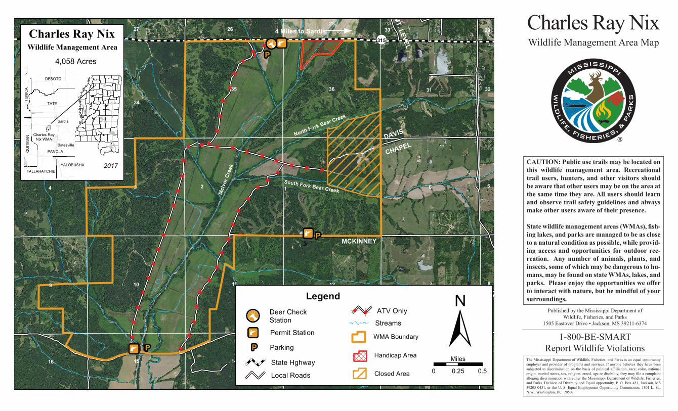
CAUTION: Public use trails may be located on this wildlife management area. Recreational trail users, hunters, and other visitors should be aware that other users may be on the area at the same time they are. All users should learn and observe trail safety guidelines and always make other users aware of their presence.
State wildlife management areas (WMAs), fish-ing lakes, and parks are managed to be as close to a natural condition as possible, while provid-ing access and opportunities for outdoor rec-reation. Any number of animals, plants, and insects, some of which may be dangerous to hu-mans, may be found on state WMAs, lakes, and parks. Please enjoy the opportunities we offer to interact with nature, but be mindful of your surroundings.
Published by the Mississippi Department ofWildlife, Fisheries, and Parks
1505 Eastover Drive • Jackson, MS 39211-6374
1-800-BE-SMARTReport Wildlife Violations
The Mississippi Department of Wildlife, Fisheries, and Parks is an equal opportunity employer and provider of programs and services. If anyone believes they have been subjected to discrimination on the basis of political affliliation, race, color, national origin, marital status, sex, religion, creed, age or disability, they may file a complaint alleging discrimination with either the Mississippi Department of Wildlife, Fisheries, and Parks, Division of Diversity and Equal opportunity, P. O. Box 451, Jackson, MS 39205-0451, or the U. S. Equal Employment Opportunity Commission, 1801 L. St., N.W., Washington, DC 20507.
Charles Ray NixWildlife Management Area Map
¸¸
¸¸
¸
¸
¸¸
¸¸
¸
¸
¸
¸¸
¸
¸
¸
¸
¸
¸¸
¸
¸¸
¸
¸¸
¸¸¸¸
¸¸
¸¸¸¸
¸¸
¸¸
¸¸
¸¸
¸¸
¸¸
¸¸
!©
!©
[_!©
4 Miles to Sardis
North Fork Bear Creek
South Fork Bear CreekMcI
vor C
reek
BALLENTINE
MCKINNEY
DAVIS
CHAPEL
ROCKHILL
HA
RM
ON
IA
LEM
ASTE
R
MEL
RO
SE
MT. LEVEL
7
623 1
9
4
11
34
35
10 12
36 3133
181415 1316
5
8
302625
27
32
28
17
29
P
P
P¬«315
YALOBUSHA¬«315
0 0.25 0.5
Miles
±Legend
Parking
Streams
WMA Boundary
Handicap Area
Permit Station!©
Local Roads
ATV OnlyDeer CheckStation[_
P
Closed Area
¸ ¸
State Hghway
Charles Ray Nix
2017
TUN
ICA
TALLAHATCHIE
PANO LA
TATE
QUITM AN
TUNICA
PANOLA
TATETUNICA
DESOTO
QU
ITM
AN
4,058 Acres
Wildlife Management Area
Sardis
Batesville
YALOBUSHA
Charles RayNix WMA