Yale Tulane Special Report- Severe Thunderstorms and Tornadoes - 28 APR 2014
21
CURRENT SITUATION YALE - TULANE ESF-8 SPECIAL REPORT SEVERE THUNDERSTORMS AND TORNADOES – APRIL 2014 AS OF 28 APRIL 2014, 1800 HRS EDT INJURED DEAD 130* 15* HEALTH AND SAFETY CONSIDERATIONS AFTER A TORNADO DISASTER DISTRESS BACKGROUND THIS THREAT IS NOT OVER SEVERE WEATHER TERMS, DEFINITIONS AND SAFETY TIPS WHAT IS A TORNADO? * Subject to change CURRENT WEATHER SITUATION A MAJOR SEVERE WEATHER OUTBREAK IS FORECAST TODAY AND/OR TONIGHT The NWS Storm Prediction Center is forecasting outbreaks of tornadoes and severe thunderstorms expected over parts of the lower Mississippi and Tennessee Valleys this afternoon and tonight. For additional details, see the current Public Severe Weather Outlook (PWO) . A multi-media briefing is also STATE GOVERNMENT OKLAHOMA DEPARTMENT OF EMERGENCY MANAGEMENT TWITTER | FACEBOOK OKLAHOMA DEPARTMENT OF PUBLIC SAFETY OKLAHOMA STATE DEPARTMENT OF HEALTH KANSAS DEPARTMENT OF EMERGENCY MANAGEMENT TWITTER | FACEBOOK KANSAS HIGHWAT PATROL KANSAS DEPARTMENT OF HEALTH AND ENVIORNMENT MISSISSIPPI DEPARTMENT OF EMERGENCY MANAGEMENT TWITTER | FACEBOOK MISSISSIPPI DEPARTMENT OF PUBLIC SAFETY MISSISSIPPI DEPARTMENT OF HEALTH AND ENVIORNMENT ARKANSAS DEPARTMENT OF EMERGENCY MANAGEMENT TWITTER | FACEBOOK ARKANSAS STATE POLICE ARKANSAS STATE DEPARTMENT OF HEALTH FEDERAL GOVERNMENT FEMA TWITTER | FACEBOOK | YOUTUBE | BLOG HHS PUBLIC HEALTH EMERGENCY – ASPR TWITTER | FACEBOOK CDC TWITTER | FACEBOOK NOAA NATIONAL SEVERE STORMS LABORA TORY NOAA NWS STORM PREDICTION CENTER NWS – LITTLE ROCK AR NWS – NORMAN, OK NWS BIRMINGHAM, AL NWS HUNTSVILLE, AL DIMRC - TORNADOES ORGANIZATION AMERICAN RED CROSS SALVATION ARMY DEVELOPING SITUATION
-
Upload
yale-tulane-esf-8-planning-and-response-network -
Category
Education
-
view
862 -
download
0
Transcript of Yale Tulane Special Report- Severe Thunderstorms and Tornadoes - 28 APR 2014

CURRENT SITUATION
YALE - TULANE ESF-8 SPECIAL REPORT
SEVERE THUNDERSTORMS AND TORNADOES – APRIL 2014
AS OF 28 APRIL 2014, 1800 HRS EDT
INJURED DEAD 130* 15*
HEALTH AND SAFETY CONSIDERATIONS AFTER A TORNADO
DISASTER DISTRESS
BACKGROUND
THIS THREAT IS NOT OVER
SEVERE WEATHER TERMS, DEFINITIONS AND SAFETY TIPS
WHAT IS A TORNADO?* Subject to change
CURRENT WEATHER SITUATION
A MAJOR SEVERE WEATHER OUTBREAK IS FORECAST TODAY AND/OR TONIGHT
The NWS Storm Prediction Center is forecasting outbreaks of tornadoes and severe thunderstorms expected over parts of the lower Mississippi and Tennessee Valleys this afternoon and tonight. For additional details, see the current Public Severe Weather Outlook (PWO).
A multi-media briefing is also available. A severe weather outbreak is forecast for Tue (04/29). See details...
STATE GOVERNMENT
OKLAHOMA DEPARTMENT OF EMERGENCY MANAGEMENTTWITTER | FACEBOOK
OKLAHOMA DEPARTMENT OF PUBLIC SAFETY
OKLAHOMA STATE DEPARTMENT OF HEALTH
KANSAS DEPARTMENT OF EMERGENCY MANAGEMENTTWITTER | FACEBOOK
KANSAS HIGHWAT PATROL
KANSAS DEPARTMENT OF HEALTH AND ENVIORNMENT
MISSISSIPPI DEPARTMENT OF EMERGENCY MANAGEMENTTWITTER | FACEBOOK
MISSISSIPPI DEPARTMENT OF PUBLIC SAFETY
MISSISSIPPI DEPARTMENT OF HEALTH AND ENVIORNMENT
ARKANSAS DEPARTMENT OF EMERGENCY MANAGEMENTTWITTER | FACEBOOK
ARKANSAS STATE POLICE
ARKANSAS STATE DEPARTMENT OF HEALTH
FEDERAL GOVERNMENTFEMATWITTER | FACEBOOK | YOUTUBE | BLOG
HHSPUBLIC HEALTH EMERGENCY – ASPRTWITTER | FACEBOOK
CDCTWITTER | FACEBOOK NOAA NATIONAL SEVERE STORMS LABORATORYNOAA NWS STORM PREDICTION CENTERNWS – LITTLE ROCK ARNWS – NORMAN, OKNWS BIRMINGHAM, ALNWS HUNTSVILLE, ALNWS NEW ORLEANS, LANWS SERVICE JACKSON MS
DIMRC - TORNADOES
ORGANIZATIONAMERICAN RED CROSSSALVATION ARMY
DEVELOPING SITUATION

• SITUATION: Outbreak of tornadoes and severe thunderstorms expected over parts of the lower Mississippi and Tennessee Valleys this afternoon and tonight
• LOCATIONS: Northern and central Mississippi Western and northern Alabama Middle Tennessee Northeast Louisiana
• HAZARDS: Numerous tornadoes, several intense and long track Widespread large hail, some baseball size Scattered damaging winds
• SUMMARY: A severe weather outbreak will continue through tonight from parts of the lower Mississippi Valley into the Tennessee Valley and central Gulf Coast states. Numerous tornadoes are expected, some of which could be intense. Very large hail and damaging straight line winds are also likely.
DEVELOPING SITUATION – 28 APR 2014
NOAA NWS STORM PREDICTION CENTER

MISSISSIPPI DEPARTMENT OF PUBLIC HEALTH
http://www.msdh.state.ms.us/
MISSISSIPPI EMERGENCY MANAGEMENT AGENCY
http://www.msema.org/
TWITTER https://twitter.com/msema
FACEBOOK https://www.facebook.com/msemaorg?ref=sgm
NOAA WEATHER RADIO FOR MISSISSIPPI
http://www.nws.noaa.gov/nwr/Maps/PHP/Mississippi.php
NATIONAL WEATHER SERVICE WATCHES, WARNINGS AND ADVISORIES
http://www.weather.gov/alerts-beta/ms.php?x=1
DEVELOPING SITUATION
(MISSISSIPPI)
FATALITIES: Unknown
INJURED: Mass casualties have occurred. Triage teams from Oxford have been dispatched to Tupelo area. Medical resupply trailer has been deployed. Jackson Team is being mobilized to respond to Winston County.
DESTRUCTION: Winston County and Tupelo – Severe damage
UTILITIES: Power lines are down
SHELTERS: 1 shelter has been open East 75 South Main Street, Tupelo MS.
STATE DECLARATION:
FEDERAL DECLATION:
MS - LINKS
SOURCES APRIL 28 - SEVERE WEATHER | LIVE MEMA PRESS CONFERENCE | MPB
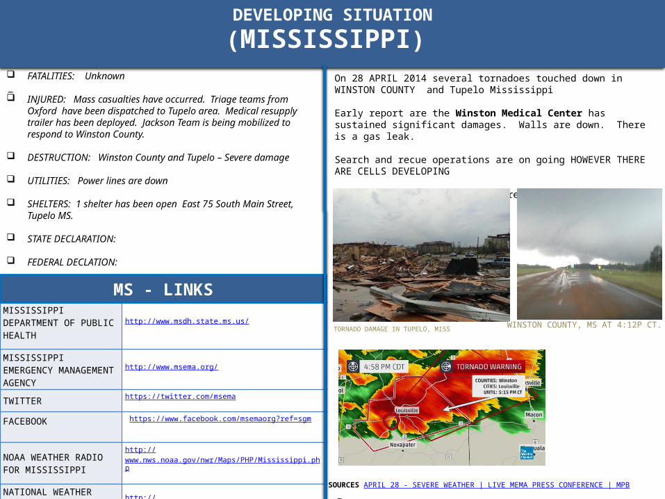
On 28 APRIL 2014 several tornadoes touched down in WINSTON COUNTY and Tupelo Mississippi
Early report are the Winston Medical Center has sustained significant damages. Walls are down. There is a gas leak.
Search and recue operations are on going HOWEVER THERE ARE CELLS DEVELOPING
Law enforcement strike teams are moving into affected areas.
.
TORNADO DAMAGE IN TUPELO, MISSWINSTON COUNTY, MS AT 4:12P CT.

BACKGROUND
A powerful storm system entered the Plains from the Rockies early on April 27th. The system dragged a cold front toward the region, and thunderstorms became likely. In all approximately 29 tornadoes were generated by this system on 27 APR 2014.
ARKANSAS• Just after 7:00 pm CDT, a supercell (storm with rotating updrafts) rapidly
intensified northwest of the Little Rock (Pulaski County) area. A destructive tornado was produced, with the tornado tracking through Mayflower and Vilonia (both in Faulkner County) before apparently dissipating (according to radar) near El Paso (White County).
• Along the way, houses and businesses were heavily damaged or reduced to rubble. As of the morning of the 28th, there were 16 fatalities reported in Arkansas.
• Farther northeast, it appears the parent storm dropped one or several more tornadoes that headed toward Center Hill (White County), Denmark (White/Jackson County line) and Jacksonport (Jackson County) AR.
• 16 fatalities have been reported
KANSASA tornado struck the community of Baxter Springs in Cherokee County at approximately 5:46 p.m. Sunday evening, April 27. Sixty to 70 homes and 20-25 businesses are reported destroyed
OKLAHOMAOne person was killed when a tornado struck Quapaw, Okla., a town about 100 miles northeast of Tulsa, around 5:30 p.m., 27 APRIL 2014.
In the picture: Rotation associated with the parent storm on 04/27/2014 was persistent for roughly 40 miles (Tornado #1) before weakening (where the gap is indicated). Another tornado (Tornado #2) was likely spawned a short time later by the same storm and tracked through White, Jackson, and Independence Counties. Note: Tornado #2 may actually be several tornadoes. This will be determined through damage surveys. The graphic is courtesy of the National Severe Storms Laboratory.
SOURCE: NATIONAL WEATHER SERVICE – Little Rock Arkansas

BACKGROUND
NOAA/NWS STORM PREDICTION CENTER – 27 APR 2014
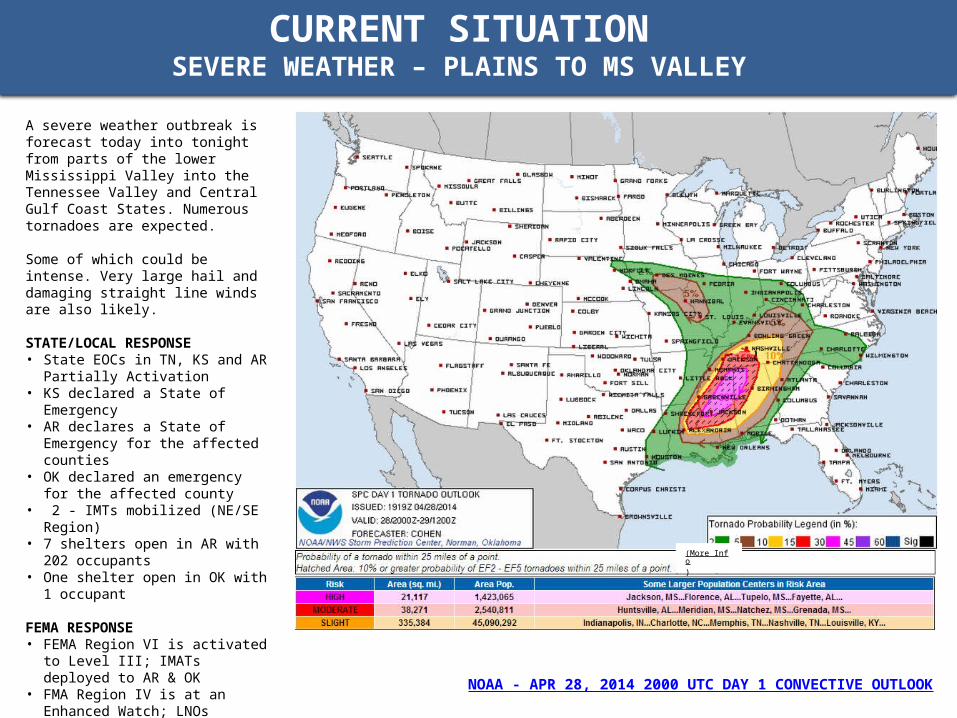
CURRENT SITUATIONSEVERE WEATHER – PLAINS TO MS VALLEY
A severe weather outbreak is forecast today into tonight from parts of the lower Mississippi Valley into the Tennessee Valley and Central Gulf Coast States. Numerous tornadoes are expected.
Some of which could be intense. Very large hail and damaging straight line winds are also likely.
STATE/LOCAL RESPONSE • State EOCs in TN, KS and AR Partially
Activation • KS declared a State of Emergency • AR declares a State of Emergency for
the affected counties• OK declared an emergency for the
affected county• 2 - IMTs mobilized (NE/SE Region) • 7 shelters open in AR with 202
occupants • One shelter open in OK with 1 occupant FEMA RESPONSE • FEMA Region VI is activated to Level III;
IMATs deployed to AR & OK • FMA Region IV is at an Enhanced
Watch; LNOs deployed to AL, TN & MS • FEMA Region VII at Watch/Steady State;
LNO on alert for Kansas • US&R TX-TF1 and White IST
activated/deploying To Little Rock AFB, AR
• US&R NE-TF1 on alert • FEMA NRCC activated to Level III
NOAA - APR 28, 2014 2000 UTC DAY 1 CONVECTIVE OUTLOOK
(More Info)
ARKANSAS DEPARTMENT OF PUBLIC HEALTH
http://www.healthyms.com/msdhsite/index.cfm/44,0,122,292,html
ARKANSAS EMERGENCY MANAGEMENT AGENCY
http://www.adem.arkansas.gov/ADEM/index.aspx?AspxAutoDetectCookieSupport=1
TWITTER https://twitter.com/ar_emergencies
FACEBOOK https://www.facebook.com/ARemergencies
NOAA WEATHER RADIO FOR MISSISSIPPI
http://www.nws.noaa.gov/nwr/Maps/PHP/Arkansas.php
NATIONAL WEATHER SERVICE WATCHES, WARNINGS AND ADVISORIES
http://www.weather.gov/alerts-beta/ar.php?x=1
SITUATION
(ARKANSAS)
FATALITIES: 14 confirmed fatalities (tornadoes)
INJURED: Conway Regional Medical Center reports treating about 100 storm victims. Nine patients have been admitted to the medical center; another 10 patients were transferred to Little Rock hospitals.
DESTRUCTION: Severe. At one point the tornado was ½ mile in width. Heaviest damages are in the towns of Mayflower and Vilonia (Faulkner County)
UTILITIES: Widespread outages throughout the impacted areas (approx. 15 K)
SHELTERS: 7 Shelters are open (201 occupants)
STATE DECLARATION: The Governor has declared a State of Emergency for the State of Arkansas (State of Arkansas – 15347)
FEDERAL DECLATION: The President directed Administrator Craig Fugate to travel to Arkansas to ensure the appropriate federal resources are being brought to bear to support the state and local efforts. The President asked the Governor to inform him and his team of any additional resources that could be provided to help the communities impacted.
AR- LINKS
SOURCES: ARKANSAS DEPARTMENT OF EMERGENCY MANAGEMENT
.
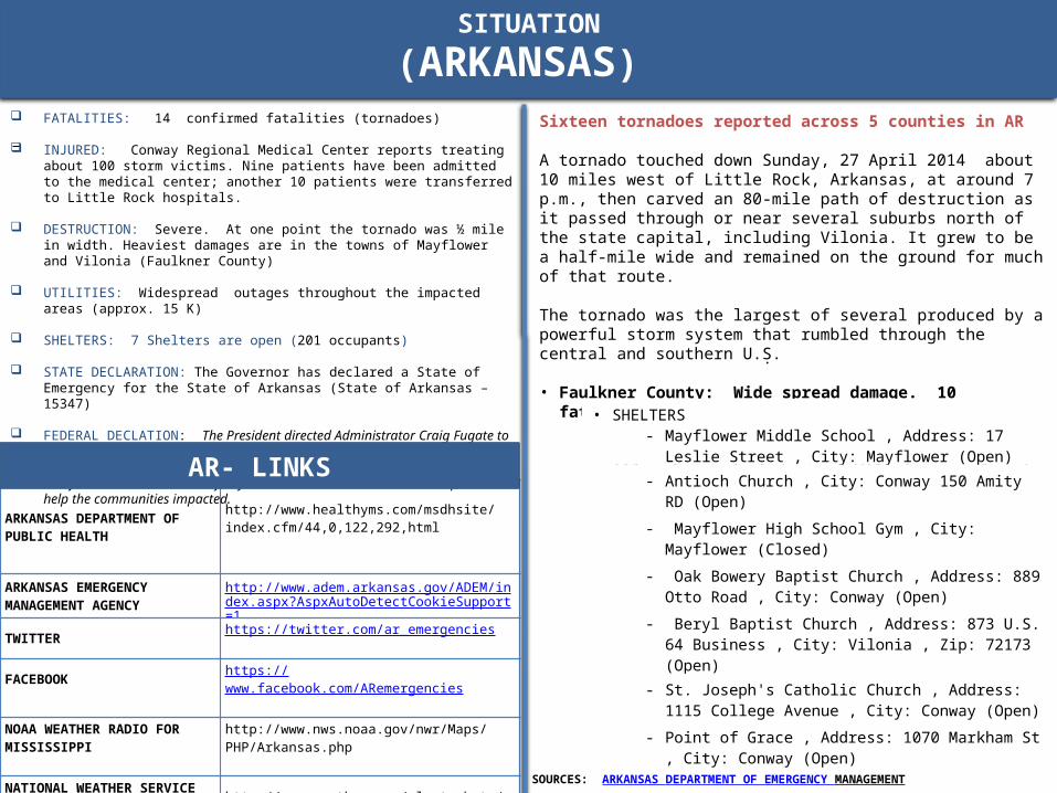
Sixteen tornadoes reported across 5 counties in AR
A tornado touched down Sunday, 27 April 2014 about 10 miles west of Little Rock, Arkansas, at around 7 p.m., then carved an 80-mile path of destruction as it passed through or near several suburbs north of the state capital, including Vilonia. It grew to be a half-mile wide and remained on the ground for much of that route.
The tornado was the largest of several produced by a powerful storm system that rumbled through the central and southern U.S.
• Faulkner County: Wide spread damage. 10 fatalities• Heaviest damages are in the towns of Mayflower and Vilonia• All main roads in/out of Vilonia are closed • Boil water order in effect for Mayflower • SHELTERS
‐ Mayflower Middle School , Address: 17 Leslie Street , City: Mayflower (Open)
‐ Antioch Church , City: Conway 150 Amity RD (Open)
‐ Mayflower High School Gym , City: Mayflower (Closed)
‐ Oak Bowery Baptist Church , Address: 889 Otto Road , City: Conway (Open)
‐ Beryl Baptist Church , Address: 873 U.S. 64 Business , City: Vilonia , Zip: 72173 (Open)
‐ St. Joseph's Catholic Church , Address: 1115 College Avenue , City: Conway (Open)
‐ Point of Grace , Address: 1070 Markham St , City: Conway (Open)
SITUATION
(ARKANSAS)
SOURCES: NWS LITTLE ROCK, ARARKANSAS DEPARTMENT OF EMERGENCY MANAGEMENT
.
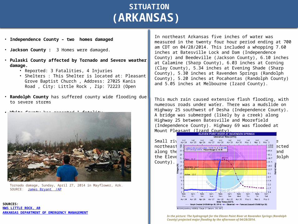
In northeast Arkansas five inches of water was measured in the twenty four hour period ending at 700 am CDT on 04/28/2014. This included a whopping 7.60 inches at Batesville Lock and Dam (Independence County) and Beedeville (Jackson County), 6.10 inches at Calamine (Sharp County), 6.03 inches at Corning (Clay County), 5.34 inches at Evening Shade (Sharp County), 5.30 inches at Ravenden Springs (Randolph County), 5.20 inches at Pocahontas (Randolph County) and 5.05 inches at Melbourne (Izard County).
This much rain caused extensive flash flooding, with numerous roads under water. There was a mudslide on Highway 25 southwest of Desha (Independence County). A bridge was submerged (likely by a creek) along Highway 25 between Batesville and Moorefield (Independence County). Highway 69 was flooded at Mount Pleasant (Izard County).
Small rivers and streams were on the rise in the northeast, with moderate to major flooding projected along the Spring River at Hardy (Sharp County) and the Eleven Point River at Ravenden Springs (Randolph County).
In the picture: The hydrograph for the Eleven Point River at Ravenden Springs (Randolph County) projected major flooding by the afternoon of 04/28/2014.
• Independence County – two homes damaged
• Jackson County : 3 Homes were damaged.
• Pulaski County affected by Tornado and Severe weather damage. • Reported: 3 Fatalities, 4 Injuries• Shelters : This Shelter is located at: Pleasant Grove Baptist Church ,
Address: 27025 Kanis Road , City: Little Rock , Zip: 72223 (Open
• Randolph County has suffered county wide flooding due to severe storms
• White County has reported 1 fatality
Tornado damage, Sunday, April 27, 2014 in Mayflower, Ark. SOURCE: James Bryant /AP
KANSAS DEPARTMENT OF PUBLIC HEALTH http://www.kdheks.gov/cphp/
KANSAS EMERGENCY MANAGEMENT AGENCY
http://www.kansastag.gov/kdem_default.asp
TWITTER https://twitter.com/okem
FACEBOOK https://www.facebook.com/pages/Kansas-Division-of-Emergency-Management/67758892983
NOAA WEATHER RADIO FOR KANSAShttp://www.nws.noaa.gov/nwr/Maps/PHP/kansas.php
NATIONAL WEATHER SERVICE WATCHES, WARNINGS AND ADVISORIES
http://alerts.weather.gov/cap/ks.php?x=1
SITUATION
(KANSAS)
FATALITIES : 0
INJURED: 25
DESTRUCTION: Sixty to 70 homes and 20-25 businesses are reported destroyed
UTILITIES:
SHELTERS: 1 shelters open
STATE DECLARATION: Gov. Sam Brownback gave approval for a State of Disaster Emergency proclamation at 6:30 p.m., 27 APR 2006
FEDERAL DECLATION:
KS - LINKS
SOURCES: KANSAS DEPARTMENT OF EMERGENCY MANAGEMENT
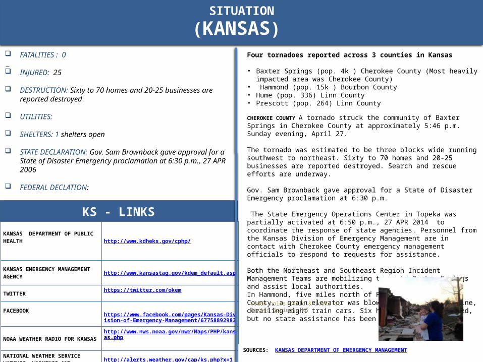
Four tornadoes reported across 3 counties in Kansas
• Baxter Springs (pop. 4k ) Cherokee County (Most heavily impacted area was Cherokee County)
• Hammond (pop. 15k ) Bourbon County • Hume (pop. 336) Linn County • Prescott (pop. 264) Linn County
CHEROKEE COUNTY A tornado struck the community of Baxter Springs in Cherokee County at approximately 5:46 p.m. Sunday evening, April 27.
The tornado was estimated to be three blocks wide running southwest to northeast. Sixty to 70 homes and 20-25 businesses are reported destroyed. Search and rescue efforts are underway.
Gov. Sam Brownback gave approval for a State of Disaster Emergency proclamation at 6:30 p.m.
The State Emergency Operations Center in Topeka was partially activated at 6:50 p.m., 27 APR 2014 to coordinate the response of state agencies. Personnel from the Kansas Division of Emergency Management are in contact with Cherokee County emergency management officials to respond to requests for assistance.
Both the Northeast and Southeast Region Incident Management Teams are mobilizing to go to Baxter Springs and assist local authorities.In Hammond, five miles north of Fort Scott in Bourbon County, a grain elevator was blown over onto a rail line, derailing eight train cars. Six homes were also damaged, but no state assistance has been requested.
.
Woman holds child & looks at Baxter Springs, KS
OKLAHOMA DEPARTMENT OF PUBLIC HEALTH
http://www.dps.state.ok.us/
OKLAHOMA EMERGENCY MANAGEMENT AGENCY
http://www.ok.gov/oem/
TWITTER https://twitter.com/okem
FACEBOOK https://www.facebook.com/OklahomaDepartmentofEmergencyManagement?sk=walll
NOAA WEATHER RADIO FOR OKLAHOMA
http://www.nws.noaa.gov/nwr/Maps/PHP/Oklahoma.php
NATIONAL WEATHER SERVICE WATCHES, WARNINGS AND ADVISORIES
http://www.weather.gov/alerts-beta/ok.php?x=1
SITUATION
(OKLAHOMA)
FATALITIES: 1 confirmed (tornadoes)
INJURED: 6 injured (5 treated and released/one hospitalized)
DESTRUCTION: Approximately 12 homes destroyed
UTILITIES: Emergency power has been restored to the water supply and the waste water treatment services.
SHELTERS: 1 shelters open
STATE DECLARATION:
FEDERAL DECLATION:
OK - LINKS
SOURCES OKLAHOMA DEPARTMENT OF EMERGENCY MANAGEMENT
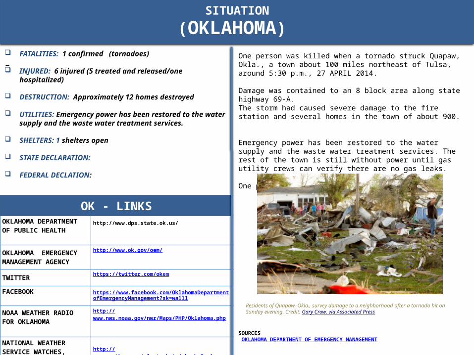
One person was killed when a tornado struck Quapaw, Okla., a town about 100 miles northeast of Tulsa, around 5:30 p.m., 27 APRIL 2014.
Damage was contained to an 8 block area along state highway 69-A. The storm had caused severe damage to the fire station and several homes in the town of about 900.
Emergency power has been restored to the water supply and the waste water treatment services. The rest of the town is still without power until gas utility crews can verify there are no gas leaks.
One person was killed .
Residents of Quapaw, Okla., survey damage to a neighborhood after a tornado hit on Sunday evening. Credit: Gary Crow, via Associated Press
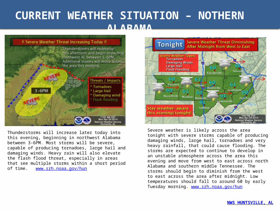
CURRENT WEATHER SITUATION – NOTHERN ALABAMA
Thunderstorms will increase later today into this evening, beginning in northwest Alabama between 3-6PM. Most storms will be severe, capable of producing tornadoes, large hail and damaging winds. Heavy rain will also elevate the flash flood threat, especially in areas that see multiple storms within a short period of time. www.srh.noaa.gov/hun
Severe weather is likely across the area tonight with severe storms capable of producing damaging winds, large hail, tornadoes and very heavy rainfall, that could cause flooding. The storms are expected to continue to develop in an unstable atmosphere across the area this evening and move from west to east across north Alabama and southern middle Tennessee. The storms should begin to diminish from the west to east across the area after midnight. Low temperatures should fall to around 60 by early Tuesday morning. www.srh.noaa.gov/hun
NWS HUNTSVILLE, AL

CURRENT WEATHER SITUATION – ALABAMA
This graphic depicts our best estimate at this time for the arrival of severe weather this evening and tonight across Central Alabama. Please keep in mind these time ranges are approximate and subject to change. http://www.srh.noaa.gov/bmx/
From this evening through Tuesday morning there will be a significant risk for severe weather across all of Central Alabama. The area we are most concerned about is highlighted in red.
NWS BIRMINGHAM, AL
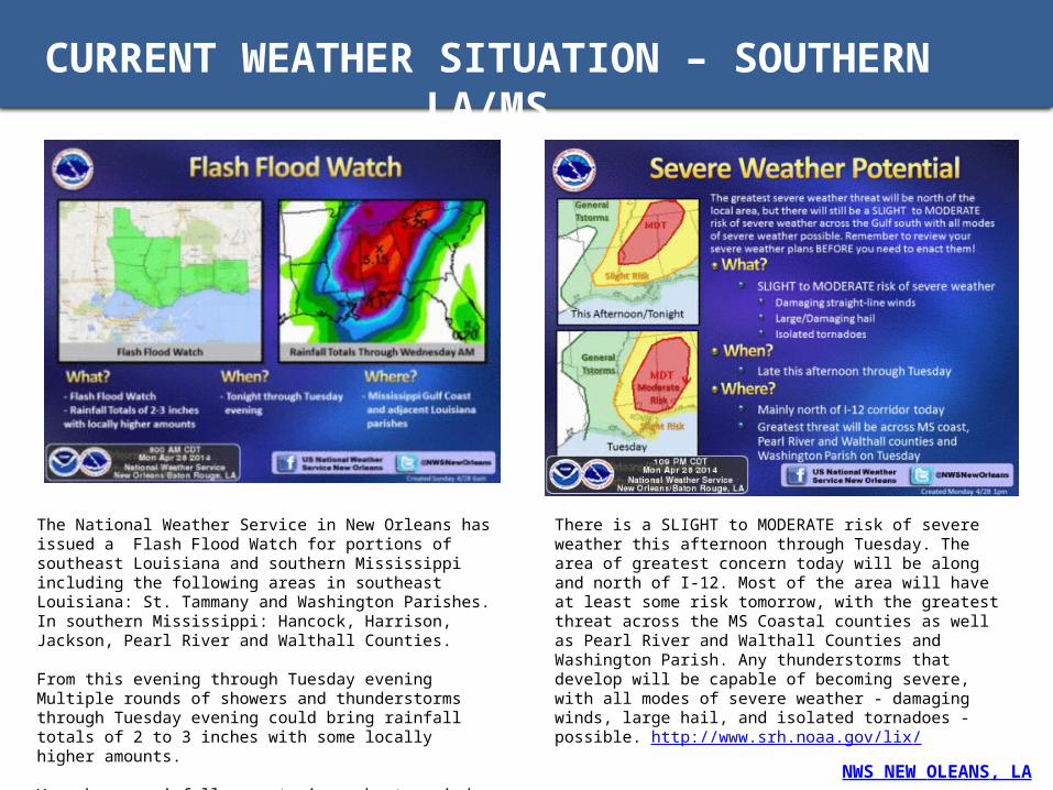
CURRENT WEATHER SITUATION – SOUTHERN LA/MS
The National Weather Service in New Orleans has issued a Flash Flood Watch for portions of southeast Louisiana and southern Mississippi including the following areas in southeast Louisiana: St. Tammany and Washington Parishes. In southern Mississippi: Hancock, Harrison, Jackson, Pearl River and Walthall Counties.
From this evening through Tuesday evening Multiple rounds of showers and thunderstorms through Tuesday evening could bring rainfall totals of 2 to 3 inches with some locally higher amounts.
Very heavy rainfall amounts in a short period of time may result in Flash Flooding of streets, highways, canals, small streams, and low lying., and poor drainage areas. http://www.srh.noaa.gov/lix/
There is a SLIGHT to MODERATE risk of severe weather this afternoon through Tuesday. The area of greatest concern today will be along and north of I-12. Most of the area will have at least some risk tomorrow, with the greatest threat across the MS Coastal counties as well as Pearl River and Walthall Counties and Washington Parish. Any thunderstorms that develop will be capable of becoming severe, with all modes of severe weather - damaging winds, large hail, and isolated tornadoes - possible. http://www.srh.noaa.gov/lix/
NWS NEW OLEANS, LA

CURRENT WEATHER SITUATION – NORTHERN LA/MS
NWS JACKSON, MS
Severe weather outbreak expected this afternoon into tonight across much of the region. Strong tornadoes will be possible with some of the storms with the greatest concern for this risk in the purple area. Very large hail, damaging winds, and flash flooding will also be of high concern over the next 12 hours. Please stay alert this afternoon and evening. This situation is particularly dangerous and numerous tornadoes have occurred with this activity.
PDS Tornado watch is in effect until 9pm.

CURRENT WEATHER SITUATION - TN
NWS NASHVILLE, TN
A Particularly Dangerous Situation Tornado Watch Number 111 is in effect until 1AM Tuesday morning.
A Flash Flood Watch continues in effect for all of Middle Tennessee until 7 PM Tuesday. Do NOT drive through where standing water covers roadways.
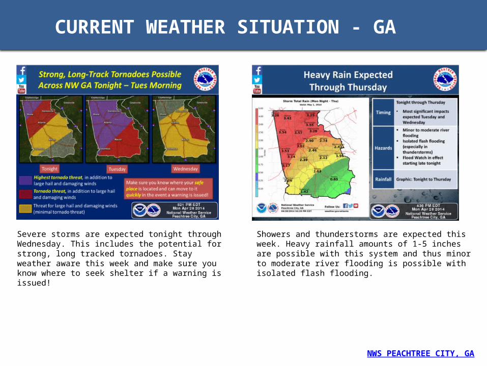
CURRENT WEATHER SITUATION - GA
Showers and thunderstorms are expected this week. Heavy rainfall amounts of 1-5 inches are possible with this system and thus minor to moderate river flooding is possible with isolated flash flooding.
Severe storms are expected tonight through Wednesday. This includes the potential for strong, long tracked tornadoes. Stay weather aware this week and make sure you know where to seek shelter if a warning is issued!
NWS PEACHTREE CITY, GA

HEALTH AND SAFETY CONSIDERATIONS AFTER A TORNADOINJURIES • Injury may result from the direct impact of a tornado, or it may occur afterward when people
walk among debris and enter damaged buildings.
• A study of injuries after a tornado in Marion, Illinois, showed that 50 percent of the tornado-related injuries were suffered during rescue attempts, cleanup, and other post-tornado activities.
GENERAL SAFETY PRECAUTIONS • Monitor battery-powered radio or television for emergency information.
• Be careful when entering any structure that has been damaged.
• Wear sturdy shoes or boots, long sleeves, and gloves when handling or walking on or near debris.
• Be aware of hazards from exposed nails and broken glass.
• Do not touch downed power lines or objects in contact with downed lines. Report electrical hazards to the police and the utility company.
• Use battery-powered lanterns.
• Never use generators, pressure washers, grills, camp stoves, or other gasoline, propane, natural gas, or charcoal-burning devices inside your home, basement, garage, or camper—or even outside near an open window, door, or vent. Carbon monoxide (co)--an odorless, colorless gas that can cause sudden illness and death if you breathe it--from these sources can build up in your home, garage, or camper and poison the people and animals inside. Seek prompt medical attention if you suspect CO poisoning and are feeling dizzy, light-headed, or nauseated.
• Hang up displaced telephone receivers that may have been knocked off by the tornado, but stay off the telephone, except to report an emergency.
• Cooperate fully with public safety officials.
During a tornado, people face hazards from extremely high winds and risk being struck by flying and falling objects. After a tornado, the wreckage left behind poses additional injury risks
• Centers for Disease Control and Prevention (CDC) – Tornadoes Information on what to do to safeguard your health and safety prior to, during and after a tornado
• Centers for Disease Control and Prevention (CDC) - Clean Up Safely After a Disaster Information from the Centers for Disease Control and Prevention (CDC) to assist individuals, families and rescue workers with safe and proper methods of disaster clean up. Topics include carbon monoxide exposure, chain saw injuries, chemical hazards, smoke from burning debris, electrical hazards, and cleaning and sanitizing with bleach.
• Small Business Administration – Emergency Preparedness Website provides a list of resources
• BusinessUSA - Emergency Preparedness - The resources below can help you develop a plan to protect your employees, lessen the financial impact of disasters, and re-open your business quickly to support economic recovery in your community.
• Occupational Safety and Health Administration (OSHA) - Tornado Preparedness and Response is designed to help businesses and their employees prepare for tornadoes, and to provide information about hazards that workers may face in the aftermath of a tornado.

SIGNS OF EMOTIONAL DISTRESS RELATED TO TORNADOES AND SEVERE STORM
Eating or sleeping too much or too little Pulling away from people and things Having low or no energy Feeling numb or like nothing matters Having unexplained aches and pains like constant stomachaches or
headaches Feeling helpless or hopeless Excessive smoking, drinking or using drugs (including prescription
medication) Feeling unusually confused or forgetful Worrying a lot of the time; feeling guilty but not sure why Feeling like you have to keep busy Hyper-vigilant- constantly thinking that something is going to happen,
including when forecasts for any storm are issued whether or not they have the chance to produce tornadoes or other severe weather
Constant yelling or fighting with family and friends; irritable* Having thoughts and memories related to the storm that you can't seem to
get out of your head; nightmares 'Triggers' such as sights or sounds that 'take you back' to the storm; sweating
or heart racing when you experience these triggers Unable to perform daily tasks like taking care of your kids or other
dependents, trouble showing up to work or school on time or at all (excessive absences), trouble concentrating and getting things done, etc.
Thinking of hurting or killing yourself or someone else.
Severe storms that produce tornadoes, strong wind gusts, lightning strikes, flash floods and other damaging effects can trigger emotional distress in those that experience them: survivors in impacted areas (including children and teens), loved ones of victims, those who have suffered damaged to or who have lost completely residential or business property, and first responders, rescue & recovery workers are all at risk.
DISTRESS SYMPTOMS AFTER A TORNADO
Disaster Distress Helpline 1-800-985-5990 orText TalkWithUs to 66746
TTY for Deaf/Hearing Impaired:1-800-846-8517
Feeling stressed?If you or someone you know has been affected by a disaster and needs immediate assistance, please call this toll-free number for information, support, and counseling. You will be connected to the nearest crisis center.
Information and Referrals Within Tornado or Severe Storm-Impacted Areas: The national '2-1-1' system offers up-to-the-minute, local, disaster-specific information and resources. Visit http://www.211.org to locate a center serving a tornado or severe storm-impacted area or just dial '2-1-1'.
SOURCE: SAMHSA – Disaster Distress
Raella Faulkner, at left, and Bobby McElroy survey what's left of their home Monday, April 28, 2014 after a tornado struck the town of Vilonia, Ark. late Sunday. (AP Photo/Karen E. Segrave)
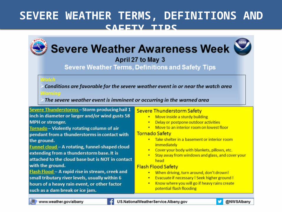
SEVERE WEATHER TERMS, DEFINITIONS AND SAFETY TIPS

WHAT IS A TORNADO?
• Nature’s most violent storms. Spawned from powerful thunderstorms, tornadoes can cause fatalities and devastate a neighborhood in seconds.
• Appears as a rotating, funnel-shaped cloud that extends from a thunderstorm to the ground with whirling winds that can reach 300 miles per hour.
• Damage paths can be in excess of one mile wide and 50 miles long.
• Occasionally, tornadoes develop so rapidly that little, if any, advance warning is possible.
• Before a tornado hits, the wind may die down and the air may become very still.
• A cloud of debris can mark the location of a tornado even if a funnel is not visible. Tornadoes generally occur near the trailing edge of a thunderstorm. It is not uncommon to see clear, sunlit skies behind a tornado.
NOTE: The Enhanced Fujita Scale, implemented in February 2007, is used by meteorologists to rate tornado damage on a scale from EF0 to EF5. The EF Scale incorporates more damage indicators and degrees of damage than the original Fujita Scale, allowing more detailed analysis and better correlation between damage and wind speed.
DESTRUCTIVE VORTEXRotating winds inside a super cell may spawn tornadoes.
Unstable conditions produce an updraft of warm, moist air
As the storm forms, cooler air wrapping in from behind causes the rising air to spin. This is called a mesocyclone.
As the mesocyclone intensifies, it may produce violent rotating winds at the surface — a tornado.
Severe weather is common in the Plains in late spring along the so-called dry line, where cool, dry air from the Rockies meets warm, moist air from the Gulf of Mexico.
SOURCE: Ready.gov
SOURCE: LA Times