YADAGIRIGUTTA TEMPLE DEVELOPMENT...
20
YADAGIRIGUTTA TEMPLE DEVELOPMENT AUTHORITY Tourism Plaza, 6-3-869, Greenlands, Begampet, Hyderabad - TS PUBLIC NOTICE INVITING OBJECTIONS AND SUGGESTIONS ON THE DRAFT MASTER PLAN FOR YADAGIRIGUTTA TEMPLE DEVELOPMENT AUTHORITY AREA 1. YTDA – CONSTITUTION The Government have constituted Yadagirigutta Temple Development Authority (YTDA) as a‘special development area’ under the provisions of AP Urban Areas (Development) Act 1975, (GOMs.No.47, dated 27-02-2015). Initial order was issued with six revenue villages and Baswapur village is subsequently included in the YTDA Area vide GO. MS. No.125, dated: 28.04.2016. The Geographical Area of the YTDA is 104.58Sq.Kms having a Population of 33,781 as per 2011 Census. Yadagiripally and Gundlapally villages were merged into single census town in the year 1981 thus having single Local Body. 1. Yadagiripalli 2. Gundlapally 3. Raigiri 4. Saidapur 5. Mallapur 6. Datarpalli 7. Baswapur 2. YTDA - JURISDICTION 2.1 The final jurisdiction of YTDA consists of Six Local Bodies having Seven Revenue villages o Yadagirpalli o Gundlapally o Saidapur o Raigir o Mallapur o Datarpalli Baswapur (Susequently added) 3. YTDA –LOCATION&BOUNDARIES 3.1 Location Yadagirgutta Temple Development Authorityis part ofYadadri- Bhongirdistrict of Telangana State in India. It is located on Hyderabad –
Transcript of YADAGIRIGUTTA TEMPLE DEVELOPMENT...

YADAGIRIGUTTA TEMPLE DEVELOPMENT AUTHORITY Tourism Plaza, 6-3-869, Greenlands, Begampet, Hyderabad - TS
PUBLIC NOTICE INVITING OBJECTIONS AND SUGGESTIONS ON
THE DRAFT MASTER PLAN
FOR
YADAGIRIGUTTA TEMPLE DEVELOPMENT AUTHORITY AREA
1. YTDA – CONSTITUTION
The Government have constituted Yadagirigutta Temple Development
Authority (YTDA) as a‘special development area’ under the provisions of
AP Urban Areas (Development) Act 1975, (GOMs.No.47, dated 27-02-2015).
Initial order was issued with six revenue villages and Baswapur village is
subsequently included in the YTDA Area vide GO. MS. No.125, dated:
28.04.2016.
The Geographical Area of the YTDA is 104.58Sq.Kms having a Population of
33,781 as per 2011 Census.
Yadagiripally and Gundlapally villages were merged into single census
town in the year 1981 thus having single Local Body.
1. Yadagiripalli
2. Gundlapally
3. Raigiri
4. Saidapur
5. Mallapur
6. Datarpalli
7. Baswapur
2. YTDA - JURISDICTION
2.1 The final jurisdiction of YTDA consists of Six Local Bodies having Seven
Revenue villages
o Yadagirpalli
o Gundlapally
o Saidapur
o Raigir
o Mallapur
o Datarpalli
Baswapur (Susequently added)
3. YTDA –LOCATION&BOUNDARIES
3.1 Location
Yadagirgutta Temple Development Authorityis part ofYadadri-
Bhongirdistrict of Telangana State in India. It is located on Hyderabad –

Warangal National Highway and is about 65 km away from the capital city
Hyderabad and 90 km away from Warangal.
3.2 Boundaries
Yadagirgutta Temple Development Authorityarea is bounded by
o South: Bhuvanagiri Mandal,
o East:Alair Mandal
o West: Turka Pally Mandal
o North: Rajapet Mandal.
3.3 Temple Complex Area
The Temple Complex is basically consisting of the Shrine, Pilgrims Residential
accommodation, facilities associated with the Complex. The nearby towns
located at:
o 6.0 Kms from Bhongir,
o 13.0 Kms from Jangaon,
o 66.0 Kms from Hyderabad,
o 91.0 Kms from Warangal.
The YTDA has acquired about Ac.1391.09gts land till date for the
development of Temple Complex with various facilities such as
1. Temple City Phase – II – 614.11 Acres
2. Temple City Phase – I – 234.02 Acres
3. Forest Area – 87.06 Acres
4. Newly proposed Land Acquisition – 132.09 Acres
5. Future Extension – 106.31 Acres
6. Newly Proposed Land Acquisition – 6.24 Acres
7. GandiCheruvu – 34.07 Acres
8. Hillock Area – 11.04 Acres
9. SwamyVariUdyanaVanam – 25 Acres
10. KalyanaMandapam – 25.36 Acres
11. VVIP Cottages – 13.26 Acres
12. Open Land – 20.11 Acres
13. Archakula& Temple Staff – 9.22 Acres
14. 200 Room & Dormitory – 15.15 Acres
15. 7000 Car Parking – 37.38 Acres
16. Bus Terminal & Shopping – 14.27 Acres
17. Electric Sub Station – 1 Acre.
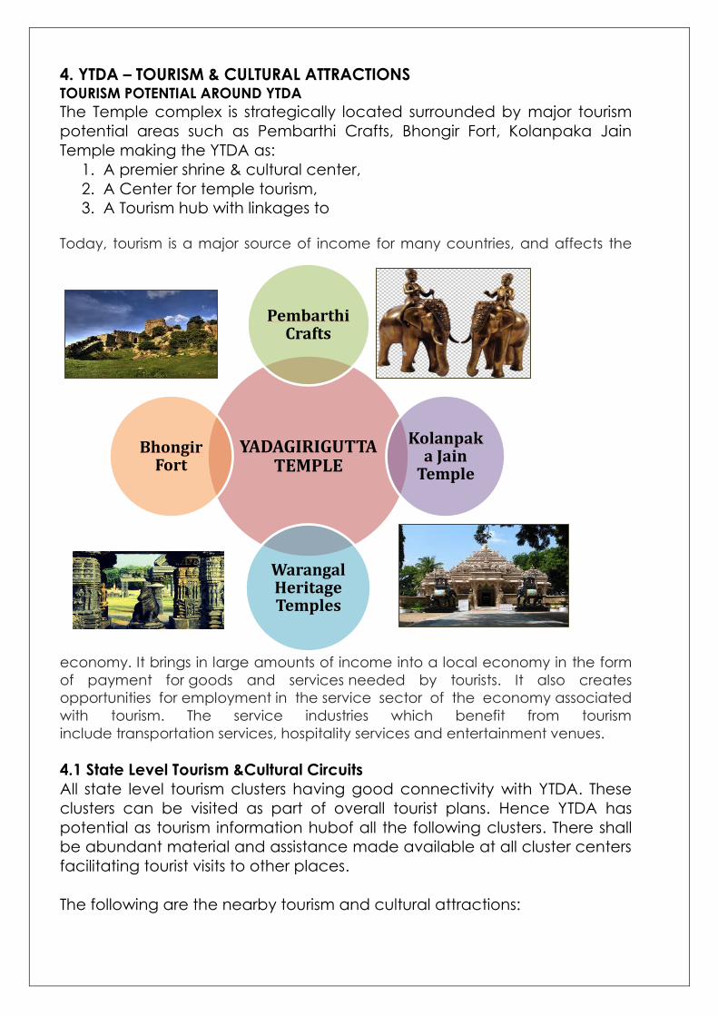
4. YTDA – TOURISM & CULTURAL ATTRACTIONS TOURISM POTENTIAL AROUND YTDA
The Temple complex is strategically located surrounded by major tourism
potential areas such as Pembarthi Crafts, Bhongir Fort, Kolanpaka Jain
Temple making the YTDA as:
1. A premier shrine & cultural center,
2. A Center for temple tourism,
3. A Tourism hub with linkages to Today, tourism is a major source of income for many countries, and affects the
economy. It brings in large amounts of income into a local economy in the form
of payment for goods and services needed by tourists. It also creates
opportunities for employment in the service sector of the economy associated
with tourism. The service industries which benefit from tourism
include transportation services, hospitality services and entertainment venues.
4.1 State Level Tourism &Cultural Circuits
All state level tourism clusters having good connectivity with YTDA. These
clusters can be visited as part of overall tourist plans. Hence YTDA has
potential as tourism information hubof all the following clusters. There shall
be abundant material and assistance made available at all cluster centers
facilitating tourist visits to other places.
The following are the nearby tourism and cultural attractions:
YADAGIRIGUTTA TEMPLE
PembarthiCrafts
Kolanpaka Jain
Temple
Warangal Heritage Temples
BhongirFort

1. BOATH, ADILABAD - Kuntala Waterfall, Pochara Waterfall,
Venkataeshwara Temple
2. DHARMAPURI - Dharmapuri Temple
3. PALAMPET - Ramappa Temple
4. WARANGAL - Warangal fort, Kush Mahal, Kakatiya musical garden
5. BHADRACHALAM - Bhadrachalam Temple, Godavari river
6. VEMULAVADA - Temple town
7. HYDERABAD - Necklace Road, Charminar, Golconda Fort
8. NAGARJUN SAGAR - Nagarjuna Sagar Dam
9. GANDIPET – Osman Sagar Lake
10. NIZAM SAGAR DAM
11. BASARA, NIZAMABAD - Saraswathy Temple, Nirmal village
4.2 REGIONAL LEVEL T&C CIRCUIT
The regional circuit is the one covers nearby places of religious, cultural,
arts important which can be covered in same day trips as part of Pilgrim
visit to YTDA.
The following are the nearby tourism and cultural attractions:
1. RATNALAYAM - Venkateshwara temple
2. WARGAL - Saraswati temple
3. NACHARAM - Narsimhaswamy temple
4. KOMURAVELLI - Mallanna temple
5. KOLANUPAKU - Jain temple
6. PEMBARTI - Regional tourism - Craft village
7. GHATKESAR - Andal Ranganayaka swamy temple
8. BHUVANAGIRI - Bhongir Fort
9. YADAGIRIGUTTA
4.3Local Level T&C Circuit
Local level tourism & cultural places are the ones located with in the YTDA
area. All temples existing and cultural facilities proposed will cover in this
category and the Draft Master Plan emphasize its immediate surrounding
development and improved connectivity for smooth flow Pilgrim, Tourists
movement.
The following are the nearby tourism and cultural attractions:
1. YADAGIRIGUTTA Main temple of Sri LaxmiNarasimhaswamy
2. PATHAGUTTA Old Sri LaxmiNarasimhaswamy Temple (2 KM)
3. LOTUS TEMPLE Manideepeshwari Temple and Museum (LESS THAN 2
KM)
4. AYYAPPA KONDA AYYAPPA SWAMY TEMPLE, Mallapur Road
5. SURENDRAPURI & KUNDA SATYANARAYANA KALADHAMAM
Panchamukha Hanuman Temple & Mythological Museum (2 KM)
6. KOLANPAKA (22 KM).

5. YTDA – DEMOGRAPHY
5.1 Population
The population for the purpose of planning broadly would fall in the
following categories in view of its nature & development,
➢ Pilgrims, Tourists – Visiting/Floating Population
➢ Temple Complex Population – Mostly residents managing various
activities of visiting/floating population
➢ Settlements Population – Existing, projected population and
additional population expected to attract due to ongoing
development activitiesof Temple Complex
5.2 Population Accommodation
The population accommodation is nothing but distribution of the projected
population among all the settlements according to its proximity to Shrine.
The population broadly would be accommodated keeping the following
aspects in view,
➢ Pilgrims, Tourists– Visiting/Floating Population
• It is likely that most of the people from this group would be of
‘day long visitors’ (Retention Period)
• A marginal percentage may stay for one night mostly with in
temple complex,
• The Temple Complex will be providing all required
accommodation and facilities to these people
• However, they need activity hubs, outside temple complex, for
spending quality time during the stay
• Accommodation may also be required outside for spilover
pilgrims
➢ Temple Complex Population – Mostly residents for managing various
temple activities and pilgrims, visiting/floating population
• This group is employees working for the temple related activities
• It is assumed that they will be accommodated with in the
proposed temple complex
• However, a small percentage from this group may settle
outside the complex for various reasons
➢ Settlements Population – Existing, projected population and
additional population expected to attract to ongoing developments
in Temple Complex,
• There are six settlements brought in to the jurisdiction of YTDA,
• The existing population will contnue to reside in their respective
settlements,

• The projected population normally adopted for Master Plan
preparation may not be suitable in the current situation in view
of major activities planned for the development of temple,
• Major portion of projected population is likely to settle in Temple
Town itself,
• Other five settlements are likely to have the natural growth
within itself,
• There will additional population to support the extra activities
come up as part of cultural and tourism development plans.
5.3 Resident Population
The YTDA area has a resident population of 33781 as per Census 2011
covering six local bodies. The pilgrim floating population is the main factor
for dominance of tertiary sector work force.
Population of YTDA
1971 – 16485
1981 –20843
1991 –27041
2001 –30998
2011 – 33781
Population - Growth Rate
It is observed that the growth rate has been gradually increasing from
1971 to 1991 to 29.73%.There is a decline in growth rate by 15 % as there
is no migration of the population to the area due to various socio
economic reasons. The proximity to Hyderabad and improved
accessibility, less travel time may be another reason for slowing down
the growth rate.
5.4 Working Population
The working population consists of about 49% of the total population.
0
10
20
30
40
1960 1970 1980 1990 2000 2010 2020
Growth Rate in YTDA Area

36%(13107)
13%(4788)
51%(18280)
PERCENTAGE OF WORKERS
Main Workers
Marginal Workers
Non Workers
About 95.65% of total working population is engaged in Primary & Tertiary
sector that reflects the predominance of Temple Complex and Agricultural
activity.
5.5Settlement Pattern of Population
The total population of YTDA area is distributed as follows in 6 Local
Bodies(villages).
S.NO VILLAGE POPULATION
(2011)
Settlements
%
1 Yadagiripalli 15232 45.09
2 Raigiri 8163 24.16
3 Mallapur 3308 09.79
4 Baswapur 2643 07.82
5 Dattarpalli 2343 06.95
6 Saidapur 2092 06.19
TOTAL 33781 100.00
45%
4%
51%
OCCUPATIONAL STRUCTURE
Primary (Cult+Ag)
Secondary Sector (HHIndustries)
Tertiary Sector (Others)

A little less than half of the population of YTDA lives in Yadagiripalli, which is
including theGundlapalli Revenue Village, next followed by Raigir. These
two villages are likely to continue its dominance in the future also due to
the fact that they are close to the temple complex and having the best
accessibility, transportation facilities.
6. YTDA – PHYSICAL FEATURES
6.1 Topography
YTDA area lies at 78.9461° E latitude and 17.5864° N longitude. The ground
slope is towards South and South – East directions of YTDA area. Average
altitude of YTDA area is 534 m above the mean sea level.
6.2 Climate
In summer, the maximum temperature is 440C whereas the minimum
temperature is 240C and in winter, the maximum temperature is 300C
whereas the minimum temperature is 130C.
6.3 Rainfall
Average Rainfall for last 10yrs is about 682 mm, which is low as against the
State average Rainfall of 800mm.
6.4 Soil Condition
YTDA area consists of Red Soil, Morrum and Loose Red Soil. Crops mostly
suitable for these types of soils and which are grown here are Maize,
Jawar& Paddy.
851.8
728.4
496
801.6
589
1126.4
843.6788.4
796.4
381.2
895.8
229.6
393
926.2
384.2 393.6
0
200
400
600
800
1000
1200
RAIN FALL IN M.M

7. EXISTING LANDUSE
Ecological features cover about 63.34% of the total area. Residential use
covers 3.75% of the total area.Land available for future growth covers
about 29.44%.
YTDA Boundary Villages Boundary Residential Use Commercial Use Industrial Use Public & semi-public Use Transportation Use Water Course Hillocks Reserve Forest Range Land Agricultural Use
Plantation Grave Yards Vacant lands
LEGEND OF MAP
Vangapalli
Cheriyal
Thurkapalli
Bhongir
Bhongir
Warangal
Kazipet
RAYIGIRI
DATHARPALLI
BASWAPUR
MALLAPUR
GUNDLAPALLI
YADAGIRIPALLI
SAIDAPUR
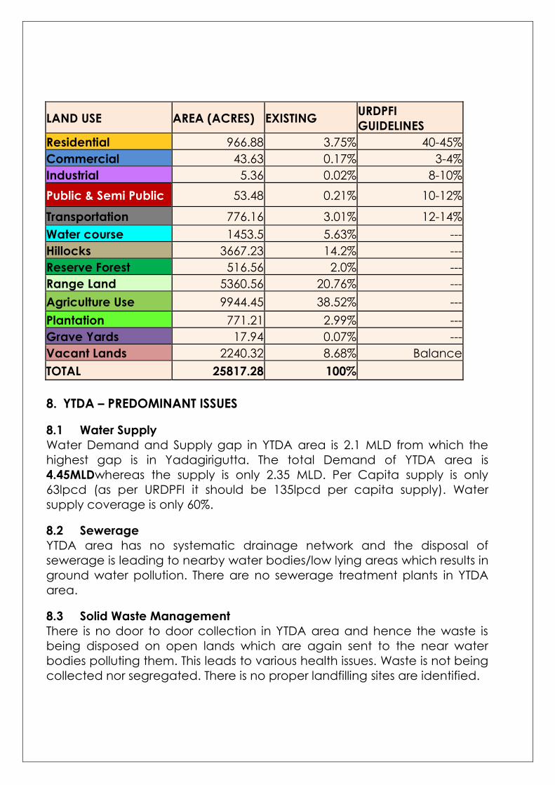
LAND USE AREA (ACRES) EXISTING URDPFI
GUIDELINES
Residential 966.88 3.75% 40-45%
Commercial 43.63 0.17% 3-4%
Industrial 5.36 0.02% 8-10%
Public & Semi Public 53.48 0.21% 10-12%
Transportation 776.16 3.01% 12-14%
Water course 1453.5 5.63% ---
Hillocks 3667.23 14.2% ---
Reserve Forest 516.56 2.0% ---
Range Land 5360.56 20.76% ---
Agriculture Use 9944.45 38.52% ---
Plantation 771.21 2.99% ---
Grave Yards 17.94 0.07% ---
Vacant Lands 2240.32 8.68% Balance
TOTAL 25817.28 100%
8. YTDA – PREDOMINANT ISSUES
8.1 Water Supply
Water Demand and Supply gap in YTDA area is 2.1 MLD from which the
highest gap is in Yadagirigutta. The total Demand of YTDA area is
4.45MLDwhereas the supply is only 2.35 MLD. Per Capita supply is only
63lpcd (as per URDPFI it should be 135lpcd per capita supply). Water
supply coverage is only 60%.
8.2 Sewerage
YTDA area has no systematic drainage network and the disposal of
sewerage is leading to nearby water bodies/low lying areas which results in
ground water pollution. There are no sewerage treatment plants in YTDA
area.
8.3 Solid Waste Management
There is no door to door collection in YTDA area and hence the waste is
being disposed on open lands which are again sent to the near water
bodies polluting them. This leads to various health issues. Waste is not being
collected nor segregated. There is no proper landfilling sites are identified.

9. YTDA - GOVERNMENT INITIATIVES
9.1 Temple Development
About Ac.1391.09gts land has been acquired for development of Temple
Complex with facilities such as;
4. Newly proposed Land Acquisition – 132.09 Acres
5. Future Extension – 106.31 Acres
7. GandiCheruvu – 34.07 Acres
8. Hillock Area – 11.04 Acres
9. SwamyVariUdyanaVanam – 25 Acres
12. Open Land – 20.11 Acres
17. Sub Station – 1 Acre
9.2 Railway Station & MMTS
Raigiri railway station should be developed with
modern facilities.MMTS is propsed from
Secunderabad to Raigiri.
9.3 Metro Rail Proposal
Four-lane road connectivity is proposed
between Raigir and Yadadri, High-
Speed metro rail is being planned

connecting to Hyderabad with an expected travel time of about Half an
Hour.
10. YTDA –SPECULATIVE GROWTH (REAL ESTATE)
10.1 The Real Estate developers have overtime active in developing land
development for open plots. About Ac.2600.00 is identified from the
satellite image under such developments.
10.2 The speculative growth does not contribute for planned development
but adversely effect the overall growth/planned development. It is an
established fact that open plots in these layouts will remain unoccupied for
decades to come, in most cases rich agriculture lands have been
converted to layouts affecting to the agriculture yields.
10.3 It is estimated that the speculative developments of plotted
development can, otherwise, accommodate about 1.60 Lakh population
that nullifies all normal projections of Draft Master Plan.
10.4 The speculative developments coming within the Settlement Planning
Area will be dealt with in the purview of Draft Zoning Regulations and the
one falling outside will have special promotion regulations.
11. POPULATION PROJECTIONS
Year Geometric
Increase Method
Incremental
Increase
Method
Arithmetical
Increase
Method
Average Of
Three Method
2019 42,435 36,862 37,240 38,846
2020 43,662 37,224 37,673 39,519
2025 50,351 38,953 39,835 43,046
2030 58,066 40,550 41,997 46,871
2035 66,962 42,017 44,159 51,046
S.NO. POPULATION PROJECTIONS BASED ON POPULATION
1 Projected settlements (6) population 51000
2 Floating population – Pilgrimage &
Tourists 1,00,000
3 Migrant Population including Service
Population (Assumed) 75,000

• Some of the tourism and pilgrims activities will also be provided
outside the temple complex.
• The Migrant and Service Population will also be there apart from the
Projected Population for YTDA Area.
• Floating Population will be accommodated in Temple Complex only.
• Taking the above aspects into consideration the projected
population for Master Plan will be 1,26,000 (51000+75000).
12. MATER PLAN PROPOSALS - APPROACH
The projected population will be assigned to each settlement
proportionately. Proper circulation pattern of the road network will be
planned connecting all the settlements.The requirements arrived for
various infrastructure facilities will be distributed based on the population
assigned to each settlement. The proposed landuse map will be
preparedfor the YTDA Area duly incorporating all aspects physical
development including housing, infrastructure etc as per the requirement.
Master Plan proposals would be finalized accordingly with a detailed Land
use plan.
13. YTDA – MASTER PLAN PROPOSALS
13.1 RECOMMENDATIONS
1. Plantation
The proposed heavy plantation finally
facilitates to have a view of the main temple
above the greenery since the built up area will
be submerged below the grown up trees.
2. Development Control
The Development will be Low Rise Medium
Density this will facilitate uninterrupted view of
the Hillock, Main Temple.
3. Recreational
All avenues, open spaces, buffer zones around
the water bodies heavy dense plantation of
local varieties will be taken up.
4. Water Bodies
All major water bodies will have water related
activities and informal squatting of pilgrims to
take rest and take food and refreshments. This is one of the main
activities of the pilgrimage which will be continued in an organized way.

5. Tourist / Cultural / Arts Hubs
Tourist / Cultural / Arts hubs will be provided along the main arterial
roads leading to the temple where the local artisans and the artisans
from outside can display their talents, arts while putting themfor sale.

6.Tourism Conceptual Approach
PANCHA NARASIMHA SWAMY KSHETRAM PANCHA BHOOTAS AS CONCEPT TO
CORRIDOR DEVELOPMENT
Yogonanda Narasimha Avataram Air
Lakshmi Narasimha Avataram Water
Ugra Narasimha Avataram Sky
Gandabheronda Naraimha Avataram Fire
Jwala Narasimha Avtaram Earth
Development of the Five Corridors:
1. National Highway 169 To Temple
2. Siddepet to Temple
3. Towards Masaipet
4. Towards Vangapalli
5. Towards Pathagutta
Temple Entrance Arch Depicting 5 elements
like Air, Water, Sky etc. and
NarasimhaSwamyAvatharams can be
proposed in the entrance of all the 5 corridors.
Railway Track / Mass Transit
Bus Route, Auto / Taxi Route
Cycle Pathway
Pedestrain Pathway
DRIVED PATHWAY TYPOLOGIES

7. Road Network
Proper circulation pattern for the road network connecting all the
settlements is proposed. National Highway (163) is passing through YTDA
which is proposed as 60 M wide.The Arterial Roads which are connecting
neighboring towns are proposed as 50 M wide road and the roads
proposed are as follows:
• Raigiri – Yadagirigutta
• Yadagirigutta – Thurkapalli
• Yadagirigutta – Vangapalli
• Yadagirigutta – Cheriyal
•
All the settlements are connecting with Sub-Arterial Road of proposed road
width as 30 M and 24 M wide.50 M wide Outer Ring Road is proposed
through all villages in order to avoid built-up area, to let through traffic flow
without interference from local traffic, to reduce congestion in the built-up
area, and to improve road safety.
The proposed road
pattern strengthens
the connectivity to
the neighbouring
development. To the
extent possible, the
roads have been
placed in
synchronization with
the existing roads.

Pedestrian & Non-Motorized Vehicle Path
The main arterial roads leading to the main temple
will have exclusive right of ways for thorough traffic,
separate tracks for the movement of pedestrian and
non-motorized vehicles.
Formal & Informal Activity Along the Main Roads
Road side formal and informal sectors can be
proposed with informal arrangement to cater the
needs of the pedestrians.
Parking Provision
Few Parking spaces for vehicles can be proposed along
the major roads.
Railway Station & MMTS
Raigiri railway station should be developed with modern
facilities. MMTS is proposed from Secunderabad to
Raigiri. Right Of Way With Proposed Metro Rail
A four lane road connectivity is proposed between
Raigir and Yadadri, High-Speed metro rail is being
planned connecting to Hyderabad with an expected
travel time of about Half an Hour.
8. PHYSICAL INFRASTRUCTURE
8.1 Water Supply
• Quantity of Water Supply should be increased by 3.25 MLD at present
and for the projected population 15.8 MLD should be increased by
the year 2035.
• Source of Water Supply should be taken by BHAGEERATHA MISSION.
• Household connections should be improved by no. 20,200 for the
year 2035 .
8.2 Swerage & Sanitation
• Underground sewerage system should be provided for YTDA area.
• Sewerage Treatment Plant should be proposed.
• 100% Sanitation facilities should be provided.
8.3 Solid Waste Management
• 100% door to door collection should be provided and segregation of
solid waste should be provided.
• Landfill sites yet to be provided in Datharpalli and Baswapur.
8.4 Transportation
Facilities for Raigiri and Bhongir Railway stations should be improved.

9. PROPOSED LANDUSE

PROPOSED LANDE USE ZONE Area in Acres % Residential 2557.25 9.91 Commercial 242.28 0.94 Industrial 162.00 0.63 Public & Semi Public 288.00 1.12 Transportation 1560.17 6.04 Water course 1454.00 5.63 Hillocks 2423.60 9.39 Reserve Forest 430.00 1.67
Conservation Zone 3339.50 13.14
Buffer Zone 297.65 1.15
Urbanisable Area 11310.85 43.81
Special development area 1698.00 6.58
TOTAL 25817 100%
10%
1%
1%
1%
6%
6%
9%
2%13%
1%
43%
6%
1%
PROPOSED LANDE USE
Residential
Commercial
Industrial
Public & Semi Public
Transportation
Water course
Hillocks
Reserve Forest
Conservation Zone
Buffer Zone
Urbanisable Area

10. YTDA – NOTIFICATION
10.1 The draft Master Plan for Yadagirigutta Temple Development
Authority is hereby notified in exercise of powers conferred under
section 8 (2) and (3) of APUA (Dev) Act, 1975 and Rule 12 of The UDA
(Hyd) Rules, 1977 inviting public objections and suggestions from any
person, body or authority in writing within a period of 15 days from
the date of publication.
10.2 The draft Master Plan and draft Zoning Regulations will be displayed
and made available for inspection at the following offices/places
from ……………2017 to ……………2017 (15 days) on all working days
from 10.30 AM to 5.00 PM.
10.3 The Draft Master Plan for YTDA with gist of the Report can also be
viewed on the web site. The objections and suggestions may also be
‘e-mailed to or may be sent by post to the following address.
10.4 Soft copy of the said Draft Master Plan for YTDA in Scale 1:15000
together with the Draft Zoning Regulations, executive summary of the
report can be purchased for Rs.500.00 at the following offices.
10.5 All objections and suggestions received will be duly examined and
considered before finalization of the said Master Plan and Zoning
Regulations and the same will be forwarded to the Government for
APPROVAL.
Dt. ……………2017 Vice-Chairman &Chief Executive Officer Hyderabad-TS Yadagirigutta Temple Development Authority