Y L U J O D A R C O G A 1 5 U nc omp ahg reN ti l F s : M ...
1
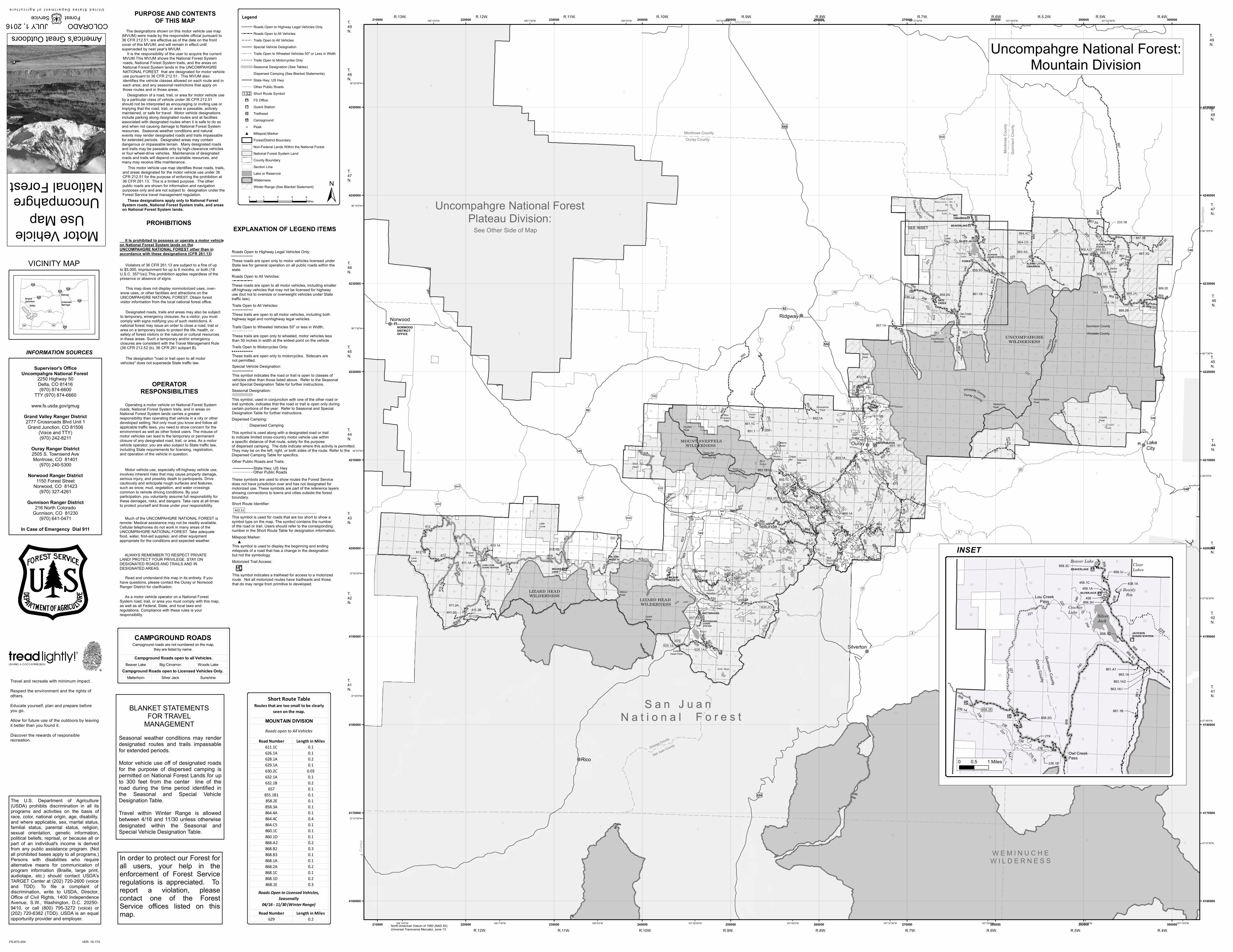
North American Datum of 1983 (NAD 83) Universal Transverse Mercator, zone 13 ! ! ! ! ! ! ! ! ! ! ! ! ! ! ! ! ! ! ! ! ! ! ! ! ! ! ! ! ! ! ! ! ! ! ! ! ! ! ! ! ! ! ! ! ! ! ! ! ! ! ! ! ! ! ! ! ! ! ! ! ! ! ! ! ! ! ! ! ! ! ! ! ! ! ! ! ! ! ! ! ! ! ! ! ! ! ! ! ! ! ! ! ! ! ! ! ! ! ! ! ! ! ! ! ! ! ! ! ! ! ! ! ! ! ! ! ! ! ! ! ! ! ! ! ! ! ! ! ! ! ! ! ! ! ! ! ! ! ! ! ! ! ! ! ! ! ! ! ! ! ! ! ! ! ! ! ! ! ! ! ! ! ! ! ! ! ! ! ! ! ! ! ! ! ! ! ! ! ! ! ! ! ! ! ! ! ! ! ! ! ! ! ! ! ! ! ! ! ! ! ! ! ! ! ! ! ! ! ! ! ! ! ! ! ! ! ! ! ! ! ! ! ! ! ! ! ! ! ! ! ! ! ! ! ! ! ! ! ! ! ! ! ! ! ! ! ! ! ! ! ! ! ! ! ! ! ! ! ! ! ! ! ! ! ! ! ! ! ! ! ! ! ! ! ! ! ! ! ! ! ! ! ! ! ! ! ! ! ! ! ! ! ! ! ! ! ! ! ! ! ! ! ! ! ! ! ! ! ! ! ! ! ! ! ! ! ! ! ! ! ! ! ! ! ! ! ! ! ! ! ! ! ! ! ! ! ! ! ! ! ! ! ! ! ! ! ! ! ! ! ! ! ! ! ! ! ! ! ! ! ! ! ! ! ! ! ! ! ! ! ! ! ! ! ! ! ! ! ! ! ! ! ! ! ! ! ! ! ! ! ! ! ! ! ! ! ! ! ! ! ! ! ! ! ! ! ! ! ! ! ! ! ! ! ! ! ! ! ! ! ! ! ! ! ! ! ! ! ! ! ! ! ! ! ! ! ! ! ! ! ! ! ! ! ! ! ! ! ! ! ! ! ! ! ! ! ! ! ! ! ! ! ! ! ! ! ! ! ! ! ! ! ! ! ! ! ! ! ! ! ! ! ! ! ! ! ! ! ! ! ! ! ! ! ! ! ! ! ! ! ! ! ! ! ! ! ! ! ! ! ! ! ! ! ! ! ! ! ! ! ! ! ! ! ! ! ! ! ! ! ! ! ! ! ! ! ! ! ! ! ! ! ! ! ! ! ! ! ! ! ! ! ! ! ! ! ! ! ! ! ! ! ! ! ! ! ! ! ! ! ! ! ! ! ! ! ! ! ! ! ! ! ! ! ! ! ! ! ! ! ! ! ! ! ! ! ! ! ! ! ! ! ! ! ! ! ! ! ! ! ! ! ! ! ! ! ! ! ! ! ! ! ! ! ! ! ! ! ! ! ! ! ! ! ! ! ! ! ! ! ! ! ! ! ! ! ! ! ! ! ! ! ! ! ! ! ! ! ! ! ! ! ! ! ! ! ! ! ! ! ! ! ! ! ! ! ! ! ! ! ! ! ! ! ! ! ! ! ! ! ! ! ! ! ! ! ! ! ! ! ! ! ! ! ! ! ! ! ! ! ! ! ! ! ! ! ! ! ! ! ! ! ! ! ! ! ! ! ! ! ! ! ! ! ! ! ! ! ! ! ! ! ! ! ! ! ! ! ! ! ! ! ! ! ! ! ! ! ! ! ! ! ! ! ! ! ! ! ! ! ! ! ! ! ! ! ! ! ! ! ! ! ! ! ! ! ! ! ! ! ! ! ! ! ! ! ! ! ! ! ! ! ! ! ! ! ! ! ! ! ! ! ! ! ! ! ! ! ! ! ! ! ! ! ! ! ! ! ! ! ! ! ! ! ! ! ! ! ! ! ! ! ! ! ! ! ! ! ! ! ! ! ! ! ! ! ! ! ! ! ! ! ! ! ! ! ! ! ! ! ! ! ! ! ! ! ! ! ! ! ! ! ! ! ! ! ! ! ! ! ! ! ! ! ! ! ! ! ! ! ! ! ! ! ! ! ! ! ! ! ! ! ! ! ! ! ! ! ! ! ! ! ! ! ! ! ! ! ! ! ! ! ! ! ! ! ! ! ! ! ! ! ! ! ! ! ! ! ! ! ! ! ! ! ! ! ! ! ! ! ! ! ! ! ! ! ! ! ! ! ! ! ! ! ! ! ! ! ! ! ! ! ! ! ! ! ! ! ! ! ! ! ! ! ! ! ! ! ! ! ! ! ! ! ! ! ! ! ! ! ! ! ! ! ! ! ! ! ! ! ! ! ! ! ! ! ! ! ! ! ! ! ! ! ! ! ! ! ! ! ! ! ! ! ! ! ! ! ! ! ! ! ! ! ! ! ! ! ! ! ! ! ! ! ! ! ! ! ! ! ! ! ! ! ! ! ! ! ! ! ! ! ! ! ! ! ! ! ! ! ! ! ! ! ! ! ! ! ! ! ! ! ! ! ! ! ! ! ! ! ! ! ! ! ! ! ! ! ! ! ! ! ! ! ! ! ! ! ! ! ! ! ! ! ! ! ! ! ! ! ! ! ! ! ! ! ! ! ! ! ! ! ! ! ! ! ! ! ! ! ! ! ! ! ! ! ! ! ! ! ! ! ! ! ! ! ! ! ! ! ! ! ! ! ! ! ! ! ! ! ! ! ! ! ! ! ! ! ! ! ! ! ! ! ! ! ! ! ! ! ! ! ! ! ! ! ! ! ! ! ! ! ! ! ! ! ! ! ! ! ! ! ! ! ! ! ! ! ! ! ! ! ! ! ! ! ! ! ! ! ! ! ! ! ! ! ! ! ! ! ! ! ! ! ! ! ! ! ! ! ! ! ! ! ! ! ! ! ! ! ! ! ! ! ! ! ! ! ! ! ! ! ! ! ! ! ! ! ! ! ! ! ! ! ! ! ! ! ! ! ! ! ! ! ! ! ! ! ! ! ! ! ! ! ! ! ! ! ! ! ! ! ! ! ! ! ! ! ! ! ! ! ! ! ! ! ! ! ! ! ! ! ! ! ! ! ! ! ! ! ! ! ! ! ! ! ! ! ! ! ! ! ! ! ! ! ! ! ! ! ! ! ! ! ! ! ! ! ! ! ! ! ! ! ! ! ! ! ! ! ! ! ! ! ! ! ! ! ! ! ! ! ! ! ! ! ! ! ! ! ! ! ! ! ! ! ! ! ! ! ! ! ! ! ! ! ! ! ! ! ! ! ! ! ! ! ! ! ! ! ! ! ! ! ! !! ! ! ! ! ! ! ! ! ! ! ! ! ! ! ! ! ! ! ! ! ! ! ! ! ! ! ! ! ! ! ! ! ! ! ! ! ! ! ! ! ! ! ! ! ! ! ! !! ! !! !!! ! ! ! ! ! ! ! ! ! ! ! ! ! ! ! ! ! ! ! ! ! ! ! ! ! ! ! ! ! ! ! ! ! ! ! ! ! ! ! ! ! ! ! ! ! ! ! ! ! ! ! ! ! ! ! ! ! ! ! ! ! ! ! ! ! ! ! ! ! ! ! ! ! ! ! ! ! ! ! ! ! ! ! ! ! ! ! ! ! ! ! ! ! ! ! ! ! ! ! ! ! ! ! ! ! ! ! ! ! ! ! ! ! ! ! ! ! ! ! ! ! ! ! ! ! ! ! ! ! ! ! ! ! ! ! ! ! ! ! ! ! ! ! ! ! ! ! ! ! !! ! ! ! ! ! ! ! ! ! ! ! ! ! ! ! ! ! ! ! ! ! ! ! ! ! ! ! ! ! ! ! ! ! ! ! ! ! ! ! ! ! ! ! ! ! ! ! ! ! ! ! ! ! ! ! ! ! ! ! ! ! ! ! ! ! ! ! ! ! ! ! ! ! ! ! ! ! ! ! ! ! ! ! ! ! ! ! ! ! ! ! ! ! ! ! ! ! ! ! ! ! ! ! ! ! ! ! ! ! ! ! ! ! ! ! ! ! ! ! ! ! ! ! ! ! ! ! ! ! ! ! ! ! ! ! ! ! ! ! ! ! ! ! ! ! ! ! ! ! ! ! ! ! ! ! ! ! ! ! ! ! ! ! ! ! ! ! ! ! ! ! ! ! ! ! ! ! ! ! ! ! ! ! ! ! ! ! ! ! ! ! ! ! ! ! ! ! ! ! ! ! ! ! ! ! ! !! ! ! ! ! ! ! ! ! ! ! ! ! ! ! ! ! ! ! ! ! ! ! ! ! ! ! ! ! ! ! ! ! ! ! ! ! ! ! ! ! ! ! ! ! ! ! ! ! ! ! ! ! ! ! ! ! ! ! ! ! ! ! ! ! ! ! ! ! ! ! ! ! ! ! ! ! ! ! ! ! ! ! ! ! ! ! ! ! ! ! ! ! ! ! ! ! ! ! ! ! ! ! ! ! ! ! ! ! ! ! ! ! ! ! ! ! ! ! ! ! ! ! ! ! ! ! ! ! ! ! ! ! ! ! ! ! ! ! ! ! ! ! ! ! ! ! ! ! ! ! ! ! ! ! ! ! ! ! ! ! ! ! ! ! ! ! ! ! !!! ! ! ! ! ! ! ! ! ! ! ! ! ! ! ! ! ! ! ! ! ! ! ! ! ! ! ! ! ! ! ! ! ! ! ! ! ! ! ! ! ! ! ! ! ! ! ! ! ! ! ! ! ! ! ! ! ! ! ! ! ! ! ! ! ! ! ! ! ! ! ! ! ! ! ! ! ! ! ! ! ! ! ! ! ! ! ! ! ! ! ! ! ! ! ! ! ! ! ! ! ! ! ! ! ! ! ! ! ! ! ! ! ! ! ! ! ! ! ! ! ! ! ! ! ! ! ! ! ! ! ! ! ! ! ! ! ! ! ! ! ! ! ! ! ! ! ) ) ) ) ) ) ) ) ) ) ) ) ) " 9 ) ) ) ) ) ) ) ) ) ) " 9 " 9 " 9 ) ) ) ) ) ) ) ) " 7 ! E ! ? " 9 " 9 ! E ! E " 9 ! E ! E ) " 7 " 7 ! E ! E " 7 ! ? WOODS LAKE MATTERHORN SUNSHINE AMPHITHEATER BIG CIMARRON Alpine Corral Beaver Park Thistle Park Moonshine Park Cocan Flats Blaine Basin Box Factory Park Hayden Peak Gray Head Wilson Peak Lizard Head Pass Lizard Head Red Mountain Pass Twin Peaks Baldy Peak Little Cone Lone Cone Lou Creek Pass Owl Creek Pass Courthouse Mountain Uncompahgre Peak Wetterhorn Peak Crystal Peak Mount Sneffels Cirque Mtn Teakettle Mtn NORWOOD DISTRICT OFFICE JACKSON GUARD STATION Ophir Needles FORKS NATE CREEK WILSON MESA TH WILSON MESA TH Crystal Lake Blue Lakes Silver Jack SILVER JACK LONE CONE GUARD STATION MATTERHORN GUARD STATION BEAVERLAKE ALPINE/ LITTLE CIMARRON ALPINE ALPINE GUARD STATION Trout Lake Lake Hope Fish Creek Reservoirs No. 1 No. 2 Hampton Lake Cowboy Lake Crystal Lake Alta Lakes MOUNT SNEFFELS WILDERNESS LIZARD HEAD WILDERNESS LIZARD HEAD WILDERNESS UNCOMPAHGRE WILDERNESS £ ¤ 550 £ ¤ 550 £ ¤ 550 G H 7 G H 46M G H 10 G H 12 G H 60M G H 57P G H 638 G H 3 G H 17 G H T60 G H 8 G H 20 G H M44 G H 3 G H 858 G H 2 ¬ « 145 ¬ « 149 ¬ « 145 ¬ « 62 ¬ « 149 G H 5 £ ¤ 550 ¬ « 62 ¬ « 149 G H 10 G H 9 225 114 118 421 139 149 126 128 475 477 240 122 139 255 149 221 421 225 114.1B 541 119.1 114 116.1C 117 112 125 222 516 128 477 421 118 225 146 155 139 131 131 131 139 139 139 516 116 116 116 124 248 155 155 149.1A 114.1A 249 244 233 219 116.1B 200 203 236 125.1A 131.1A 251 112 110 110 113 105 115 236.1A 237 233.1B 233 867.3C 867.2A 867.2C 867.3A 870.2A 868.2D 867.3G 867.3H 867.3B 868.2E 851.1 861.1 630.2C 603.1A 540.1E 510.3C 512.1A1 512.1H 574.1A 663.1A 508.3D 540.1A 855.1A 556.1A 538.1D 512.1A 515.1A 538.1C 615.1A 871.2B 872.1A 541.1A 869.1A 852.1A 611.2B 538.1A 402.9A1 538.1B 537.1D 402.9B 618.C1 536.2B 513.2D 857.1A 402.8C 536.1B 540.1B 530.1A 125 515.1B 611.2C 611.1A 618.1D 611.2A 402.8Q 508.A3 632.1C 540.2A 630.2A 611.1C 531.1A 871.2A 515.1C 508.3A 872.1B 858.2G 546 514.1B 650.1A 853.1A 860.1C 609.2A 858.3G 619.1A 612.1B 851.1C 544.3C 610.1A 853.1B1 503.1A 851.1 574.1A 864 530 508 858 506 510 609 540 611 536 512 534 520 531 513 618 857 545 515 551 535 876 516 537 878 869 612 615 539 556 557 514 886 650 623 546 554 642 616 532 630 860 626 651 631 524 574 887 863 648 548 523 562 884 625 663 541 645 637 872 627 850 628 638 526 560 550 549 621 517 622 571 871 565 553 527 619 632 838 543 896 521 593 629 873 123 618 402 526 618 512 869 632 508 512 603 531 516 878 530 858 860 574 611 551 626 615 629.1A 625 540 650 551 540 630 537 642 623 540 648 513 512 540 867.3J 868.2B 868.1B 868.B2 867 868 47 877 236 868 867 868 870 402 556 506 508 520 544 402 402 402 515 515 512.1H1 402 402 535 535.1A 535.1B 535.C1 562 562.1A 402.9G 532 510.3C1 510.A3 537.A1 514 514.1F 514.1E 556 513 513 538 538 538 538.1C 538.1C1 644 634 634 551.1A 402.8F 559 540 527.1B 510.1A 510.3C2 402.8B 547 612 611 618 657 632.1A 858 860.1D 858 858 864.4C 868.1D 868.1C 868.1A 868.2A 853 853.1B 864.4A 852 869 853.1C 887 864 611 611.2D 868.A2 508.3B 535.1A 632.1B 639 855.1B1 864.C5 868.B3 868.1E 626.1A ¬ « 145 A 850 853.1C1 861.1B 895 869.3A ! ! ! ! ! ! ! Uncompahgre National Forest Plateau Division: See Other Side of Map Ouray RD N orw o o d R D Gunnison County Hinsdale County San Juan San Juan National Forest National Forest Ouray RD Gunnison RD H i n sda l e C o u nt y O u r a y C o u n t y G u n n i s o n C o u n t y S a n Mig uel C ou nty O u r a y C ou n t y O u r a y C o u n ty WEMINUCHE WEMINUCHE WILDERNESS WILDERNESS 2 2 12 15 12 3 32 31 34 11 16 29 7 17 27 11 27 35 17 3 10 21 14 19 15 1 3 21 16 11 31 33 2 2 27 31 7 21 15 2 25 16 26 33 27 30 16 18 1 23 36 1 34 36 6 22 23 25 26 8 26 25 23 4 1 22 34 23 20 23 11 18 1 5 12 16 17 19 36 23 30 17 24 10 11 20 26 32 1 4 20 8 15 32 15 29 8 12 30 17 3 18 1 28 34 16 5 19 31 35 2 23 6 16 28 7 23 10 10 25 10 25 1 24 2 35 9 5 34 14 29 16 18 25 29 30 6 10 24 22 29 13 24 31 27 31 35 17 1 28 10 9 9 19 27 22 26 16 23 16 14 20 5 31 6 24 6 9 24 17 4 16 28 3 28 1 32 22 2 24 30 13 32 11 14 1 27 30 15 4 23 23 10 5 24 9 12 35 15 26 32 10 33 18 27 29 17 5 15 33 10 24 36 34 36 29 16 7 17 5 22 30 9 7 30 9 34 27 23 22 33 1 8 9 9 29 9 21 15 23 2 10 21 15 28 8 2 14 25 26 16 32 7 22 22 14 34 34 30 18 3 20 21 6 3 31 22 30 30 14 19 34 27 36 19 13 24 26 8 32 3 4 1 26 18 11 19 23 7 9 6 14 20 29 8 30 22 31 7 33 24 24 2 14 6 26 13 31 27 16 10 11 1 3 6 12 35 32 33 12 32 16 9 8 6 31 26 25 18 4 34 3 29 23 24 33 2 12 12 10 22 29 14 25 29 20 14 15 2 2 4 31 35 15 34 31 22 11 30 8 29 5 17 13 3 14 23 15 16 36 27 2 36 19 21 14 31 7 24 12 21 35 7 5 20 8 17 33 28 24 36 16 22 9 14 12 5 27 25 30 10 23 27 13 34 35 5 8 26 2 17 12 1 13 28 31 13 13 21 8 2 3 2 29 32 7 28 5 24 3 25 27 12 21 31 28 33 30 33 13 17 16 22 33 10 17 24 4 12 4 19 11 36 10 29 5 3 19 35 21 3 3 14 14 2 2 13 18 6 10 17 17 22 36 25 18 21 25 6 18 15 3 7 9 14 27 4 21 23 19 16 10 20 26 23 4 4 26 28 22 4 34 20 8 20 10 14 29 21 1 20 9 9 36 1 11 20 18 8 32 22 8 32 24 6 14 11 36 6 26 20 10 27 30 18 14 8 25 15 33 7 15 29 12 6 22 20 9 35 29 33 13 13 9 32 28 22 27 6 3 35 11 21 33 29 36 21 22 3 8 20 12 3 1 13 3 5 13 4 5 34 21 17 5 4 32 19 34 12 30 5 25 28 36 13 26 32 4 10 19 29 1 21 32 15 31 8 10 6 24 14 19 12 18 18 6 35 12 21 11 27 19 35 33 29 33 11 3 34 13 35 29 23 25 4 4 25 26 28 17 12 16 8 32 15 23 7 1 16 36 26 15 9 11 34 28 35 11 21 15 11 30 18 19 5 32 13 4 15 28 20 16 9 34 27 19 35 13 19 7 20 25 20 28 21 26 7 36 24 28 33 4 2 21 25 15 34 27 4 35 25 17 28 26 7 15 22 33 8 20 34 33 20 11 29 25 14 11 17 13 28 35 5 12 31 Silverton Rico Lake City Ouray Telluride Norwood Ridgway 107°22'30"W 107°22'30"W 107°30'0"W 107°30'0"W 107°37'30"W 107°37'30"W 107°45'0"W 107°45'0"W 107°52'30"W 107°52'30"W 108°0'0"W 108°0'0"W 108°7'30"W 108°7'30"W 108°15'0"W 108°15'0"W 107°15'0"W 38°22'30"N 38°22'30"N 38°15'0"N 38°15'0"N 38°7'30"N 38°7'30"N 38°0'0"N 38°0'0"N 37°52'30"N 37°52'30"N 37°45'0"N 37°45'0"N 37°37'30"N 37°37'30"N 210000 210000 220000 220000 230000 230000 240000 240000 250000 250000 260000 260000 270000 270000 280000 280000 290000 290000 300000 300000 4160000 4160000 4170000 4170000 4180000 4180000 4190000 4190000 4200000 4200000 4210000 4210000 4220000 4220000 4230000 4230000 4240000 4240000 4250000 4250000 FS-873-204 The U.S. Department of Agriculture (USDA) prohibits discrimination in all its programs and activities on the basis of race, color, national origin, age, disability, and where applicable, sex, marital status, familial status, parental status, religion, sexual orientation, genetic information, political beliefs, reprisal, or because all or part of an individual's income is derived from any public assistance program. (Not all prohibited bases apply to all programs.) Persons with disabilities who require alternative means for communication of program information (Braille, large print, audiotape, etc.) should contact USDA's TARGET Center at (202) 720-2600 (voice and TDD). To file a compliant of discrimination, write to USDA, Director, Office of Civil Rights, 1400 Independence Avenue, S.W., Washington, D.C. 20250- 9410, or call (800) 795-3272 (voice) or (202) 720-6382 (TDD). USDA is an equal opportunity provider and employer. T. 49 N. T. 48 N. T. 46 N. T. 45 N. T. 43 N. T. 42 N. T. 48 N. T. 47 N. T. 46 N. T. 44 N. T. 43 N. T. 42 N. In order to protect our Forest for all users, your help in the enforcement of Forest Service regulations is appreciated. To report a violation, please contact one of the Forest Service offices listed on this map. T. 47 N. T. 44 N. T. 41 N. T. 41 N. T. 45 N. T. 49 N. BLANKET STATEMENTS FOR TRAVEL MANAGEMENT United States Department of Agriculture COLORADO JULY 1, 2016 Forest Service America's Great Outdoors National Forest Uncompahgre Use Map Motor Vehicle Seasonal weather conditions may render designated routes and trails impassable for extended periods. Motor vehicle use off of designated roads for the purpose of dispersed camping is permitted on National Forest Lands for up to 300 feet from the center line of the road during the time period identified in the Seasonal and Special Vehicle Designation Table. Travel within Winter Range is allowed between 4/16 and 11/30 unless otherwise designated within the Seasonal and Special Vehicle Designation Table. INFORMATION SOURCES Supervisor's Office Uncompahgre National Forest 2250 Highway 50 Delta, CO 81416 (970) 874-6600 TTY (970) 874-6660 www.fs.usda.gov/gmug Grand Valley Ranger District 2777 Crossroads Blvd Unit 1 Grand Junction, CO 81506 (Voice and TTY) (970) 242-8211 Ouray Ranger District 2505 S. Townsend Ave Montrose, CO 81401 (970) 240-5300 Norwood Ranger District 1150 Forest Street Norwood, CO 81423 (970) 327-4261 Gunnison Ranger District 216 North Colorado Gunnison, CO 81230 (970) 641-0471 In Case of Emergency Dial 911 SEE INSET ! ! ! ! ! ! ! ! ! ! ! ! ! ! ! ! ! ! ! ! ! ! ! ! ! ! ! ! ! ! ! ! ! ! ! ! ! ! ! ! ! ! ! ! ! ! ! ! ! ! ! ! ! ! ! ! ! ! ! ! ! ! ! ! ! ! ! ! ! ! ! ! ! ! ! ! ! ! ! ! ! ! ! ! ! ! ! ! ! ! ! ! ! ! ! ! ! ! ! ! ! ! ! ! ! ! ! ! ! ! ! ! ! ! ! ! ! ! ! ! ! ! ! ! ! ! ! ! ! ! ! ! ! ! ! ! ! ! ! ! ! ! ! ! ! ! ! ! ! ! ! ! ! ! ! ! ! ! ! ! ! ! ! ! ! ! ! ! ! ! ! ! ! ! ! ! ! ! ! ! ! ! ! ! ! ! ! ! ! ! ! ! ! ! ! ! ! ! ! ! ! ! ! ! ! ! ! ! ! ! ! ! ! ! ! ! ! ! ! ! ! ! ! ! ! ! ! ! ! ! ! ! ! ! ! ! ! ! ! ! ! ! ! ! ! ! ! ! ! ! ! ! ! ! ! ! ! ! ! ! ! ! " 9 " 9 ) ) " 7 ! E ! E 838 858 863 236 236 219.1B 236 236.1A 858 858.2E 858.3H 458 458.1A 458.1C 858.3C 858.1D 838.1A 858 858 858.3J 861.1B 861.1 863.1A 863.1A2 863.1A1 861.A1 858.2G 858.3G 221 244 249 219 222 240 236 225 237 221 236.1B 219 BEAVERLAKE SILVERJACK Lou Creek Pass Owl Creek Pass JACKSON GUARD STATION Silver Jack Rowdy Res Clear Lakes Cowboy Lake Beaver Lake 11 3 19 15 36 34 23 20 10 22 27 6 1 30 9 26 16 22 29 21 18 3 14 8 2 13 15 9 13 17 5 10 15 12 32 16 7 25 35 28 31 INSET Ouray County Gunnison County 0 1 0.5 Miles Travel and recreate with minimum impact. Respect the environment and the rights of others. Educate yourself, plan and prepare before you go. Allow for future use of the outdoors by leaving it better than you found it. Discover the rewards of responsible recreation. ! ( ! ( ! ( ! ( § ¨ ¦ 25 § ¨ ¦ 70 § ¨ ¦ 70 § ¨ ¦ 76 § ¨ ¦ 40 § ¨ ¦ 25 £ ¤ 50 £ ¤ 160 £ ¤ 160 Grand Junction Delta Denver Colorado Springs VICINITY MAP VER: 16-174 PROHIBITIONS It Is prohibited to possess or operate a motor vehicle on National Forest System lands on the UNCOMPAHGRE NATIONAL FOREST other than in accordance with these designations (CFR 261.13) Violators of 36 CFR 261.13 are subject to a fine of up to $5,000, imprisonment for up to 6 months, or both (18 U.S.C. 3571(e)).This prohibition applies regardless of the presence or absence of signs. This map does not display nonmotorized uses, over- snow uses, or other facilities and attractions on the UNCOMPAHGRE NATIONAL FOREST. Obtain forest visitor information from the local national forest office. Designated roads, trails and areas may also be subject to temporary, emergency closures. As a visitor, you must comply with signs notifying you of such restrictions. A national forest may issue an order to close a road, trail or area on a temporary basis to protect the life, health, or safety of forest visitors or the natural or cultural resources in these areas. Such a temporary and/or emergency closures are consistent with the Travel Management Rule (36 CFR 212.52 (b), 36 CFR 261 subpart B). The designation "road or trail open to all motor vehicles" does not supersede State traffic law. OPERATOR RESPONSIBILITIES Operating a motor vehicle on National Forest System roads, National Forest System trails, and in areas on National Forest System lands carries a greater responsibility than operating that vehicle in a city or other developed setting. Not only must you know and follow all applicable traffic laws, you need to show concern for the environment as well as other forest users. The misuse of motor vehicles can lead to the temporary or permanent closure of any designated road, trail, or area. As a motor vehicle operator, you are also subject to State traffic law, including State requirements for licensing, registration, and operation of the vehicle in question. Motor vehicle use, especially off-highway vehicle use, involves inherent risks that may cause property damage, serious injury, and possibly death to participants. Drive cautiously and anticipate rough surfaces and features, such as snow, mud, vegetation, and water crossings common to remote driving conditions. By your participation, you voluntarily assume full responsibility for these damages, risks, and dangers. Take care at all times to protect yourself and those under your responsibility. Much of the UNCOMPAHGRE NATIONAL FOREST is remote. Medical assistance may not be readily available. Cellular telephones do not work in many areas of the UNCOMPAHGRE NATIONAL FOREST. Take adequate food, water, first-aid supplies, and other equipment appropriate for the conditions and expected weather. ALWAYS REMEMBER TO RESPECT PRIVATE LAND! PROTECT YOUR PRIVILEGE. STAY ON DESIGNATED ROADS AND TRAILS AND IN DESIGNATED AREAS. Read and understand this map in its entirety. If you have questions, please contact the Ouray or Norwood Ranger District for clarification. As a motor vehicle operator on a National Forest System road, trail, or area you must comply with this map, as well as all Federal, State, and local laws and regulations. Compliance with these rules is your responsibility. R.12W. R.11W. R.7W. R.6W. R.5W. R.4W. R.5.2W. R.13W. R.10W. R.9W. R.8W. Montrose County Ouray County Montrose County Gunnison County Dolores County San Juan County San Miguel County San Juan County R.12W. R.11W. R.10W. R.8W. R.7W. R.5W. R.4W. R.6W. R.9W. Roads Open to Highway Legal Vehicles Only: These roads are open only to motor vehicles licensed under State law for general operation on all public roads within the state. EXPLANATION OF LEGEND ITEMS Trails Open to All Vehicles: These trails are open to all motor vehicles, including both highway legal and nonhighway legal vehicles. Roads Open to All Vehicles: These roads are open to all motor vehicles, including smaller off-highway vehicles that may not be licensed for highway use (but not to oversize or overweight vehicles under State traffic law). Seasonal Designation: This symbol, used in conjunction with one of the other road or trail symbols, indicates that the road or trail is open only during certain portions of the year. Refer to Seasonal and Special Designation Table for further instructions. Trails Open to Motorcycles Only: These trails are open only to motorcycles. Sidecars are not permitted. Trails Open to Wheeled Vehicles 50" or less in Width: These trails are open only to wheeled, motor vehicles less than 50 inches in width at the widest point on the vehicle. Special Vehicle Designation: This symbol indicates the road or trail is open to classes of vehicles other than those listed above. Refer to the Seasonal and Special Designation Table for further instructions. Dispersed Camping: This symbol is used along with a designated road or trail to indicate limited cross-country motor vehicle use within a specific distance of that route, solely for the purpose of dispersed camping. The dots indicate where this activity is permitted. They may be on the left, right, or both sides of the route. Refer to the Dispersed Camping Table for specifics. ! ! ! ! ! ! Dispersed Camping Motorized Trail Access: This symbol indicates a trailhead for access to a motorized route. Not all motorized routes have trailheads and those that do may range from primitive to developed. ! E Milepost Marker: This symbol is used to display the beginning and ending mileposts of a road that has a change in the designation but not the symbology. # Short Route Identifier: This symbol is used for roads that are too short to show a symbol type on the map. The symbol contains the number of the road or trail. Users should refer to the corresponding number in the Short Route Table for designation information. 402.3J Other Public Roads and Trails: These symbols are used to show routes the Forest Service does not have jurisdiction over and has not designated for motorized use. These symbols are part of the reference layers showing connections to towns and cities outside the forest boundary. Other Public Roads State Hwy; US Hwy Uncompahgre National Forest: Mountain Division Roads Open to Highway Legal Vehicles Only Roads Open to All Vehicles Trails Open to All Vehicles Special Vehicle Designation Trails Open to Wheeled Vehicles 50" or Less in Width !!!!!! Trails Open to Motorcycles Only Seasonal Designation (See Tables) ! ! ! ! Dispersed Camping (See Blanket Statements) State Hwy; US Hwy Other Public Roads ( 132 Short Route Symbol ! ? FS Office " 7 Guard Station ! E Trailhead " 9 Campground ) Peak # Milepost Marker Forest/District Boundary Non-Federal Lands Within the National Forest National Forest System Land County Boundary Section Line Lake or Reservoir Wilderness Winter Range (See Blanket Statement) Legend ± 0 1 2 3 4 Miles Beaver Lake Big Cimarron Woods Lake Matterhorn Silver Jack Sunshine CAMPGROUND ROADS Campground roads are not numbered on the map, they are listed by name. Campground Roads open to all Vehicles. Campground Roads open to Licensed Vehicles Only. Montrose Gunnison Cortez PURPOSE AND CONTENTS OF THIS MAP The designations shown on this motor vehicle use map (MVUM) were made by the responsible official pursuant to 36 CFR 212.51; are effective as of the date on the front cover of this MVUM; and will remain in effect until superceded by next year's MVUM. It is the responsibility of the user to acquire the current MVUM.This MVUM shows the National Forest System roads, National Forest System trails, and the areas on National Forest System lands in the UNCOMPAHGRE NATIONAL FOREST that are designated for motor vehicle use pursuant to 36 CFR 212.51. This MVUM also identifies the vehicle classes allowed on each route and in each area; and any seasonal restrictions that apply on those routes and in those areas. Designation of a road, trail, or area for motor vehicle use by a particular class of vehicle under 36 CFR 212.51 should not be interpreted as encouraging or inviting use or implying that the road, trail, or area is passable, actively maintained, or safe for travel. Motor vehicle designations include parking along designated routes and at facilities associated with designated routes when it is safe to do so and when not causing damage to National Forest System resources. Seasonal weather conditions and natural events may render designated roads and trails impassable for extended periods. Designated areas may contain dangerous or impassable terrain. Many designated roads and trails may be passable only by high-clearance vehicles or four-wheel-drive vehicles. Maintenance of designated roads and trails will depend on available resources, and many may receive little maintenance. These designations apply only to National Forest System roads, National Forest System trails, and areas on National Forest System lands. This motor vehicle use map identifies those roads, trails, and areas designated for the motor vehicle use under 36 CFR 212.51 for the purpose of enforcing the prohibition at 36 CFR 261.13. This is a limited purpose. The other public roads are shown for information and navigation purposes only and are not subject to designation under the Forest Service travel management regulation. Road Number Length in Miles 611.1C 0.1 626.1A 0.1 628.1A 0.2 629.1A 0.1 630.2C 0.03 632.1A 0.1 632.1B 0.2 657 0.1 855.1B1 0.1 858.2E 0.1 858.3A 0.1 864.4A 0.1 864.4C 0.4 864.C5 0.1 860.1C 0.1 860.1D 0.1 868.A2 0.2 868.B2 0.3 868.B3 0.1 868.1A 0.1 868.2A 0.2 868.1C 0.1 868.1D 0.2 868.1E 0.3 Road Number Length in Miles 629 0.2 Short Route Table Routes that are too small to be clearly seen on the map. MOUNTAIN DIVISION Roads open to All Vehicles Roads Open to Licensed Vehicles, Seasonally 04/16 - 11/30 (Winter Range)
Transcript of Y L U J O D A R C O G A 1 5 U nc omp ahg reN ti l F s : M ...
North American Datum of 1983 (NAD 83)Universal Transverse Mercator, zone 13
!
!
! !
!
!
!
!
!
!
!
!
!
!
!
!
!
!
!
!
! !
!
!
!
!
!
!
!
!
!
!
!
!
!
!!
!
!
!!
!
!!
!
!
!
!
!
!
!
!
!
!
!
!
!
!
!
!
!
!
!
!
!
!
!
!
!
!
!
!
!
!
!
!
!
!
!
!
!
!
!
!
!
!
!
!
!
!
!
!
!
!
!
!
!
!
!
!
!
!
!
!
!
!
!
!
!
!
! !
!
!
!
!
!
!
!
!
!
!
!
!
!
!
!
!
!
!
!
!
!!
!
!
!
!
!!
!
!
!
!
!!
!
!!
!
!
!!
!!
!
!
!
!
!
!
!
!!
!
!
!!
!!
!
!
!
!
!
!
!
!
!
!
!
!
!!
!
!
!
!
!
!
!
!
!
!
!
!
!
!
!
!
!
!
!
!
!
!
!
!
!
!
!
!
!
!
!
!
!
!
!
!
!
!
!
!!
!
! !
!
!
!
!!
!
!!
!
!
!
!
!
!
!
!!
!
!
!!
!
!
!
!
!
!
!
!
!
!
!
! !
!
!!
!
!
!
! !
!
!
!
!
!
!!
!!
!
!
!
!
!
!
!
!!
!
!
!
!!
!
!
!
!
!
!
!!
!
!!
!!
!
!
!
!
! !
!
!
!
!
!
! !!
! !
!!
!
!
!
!
!
!!
!
!
!
!
!!
!!
!
!
!
!
!
!
!
!
!
!
!
!
!
!
!
!
!
!
!
!
!
!
!
!
!
!
!
!
!
!
!
!
!
!
!
!
!
!
!
!
!
!
!
!
!!
!!
!
!!
!
!
!
!
!
!
!
!
!
!
!
!
!
!
!
!
!
!
!
! !
!
!!
!
!!
!
!!
!
!
!
!
!
!
!
!!
!
!
!
!
!
!
!
!
! ! !
!
!
!
!
!
!
!
!
!
!
!
!
!
!
!
! !
!
!
!
!
!
!
!
! !
!
!
! !
!
!
!
!
!!
!
!
!
!
!
!!
!
!
!
!
!
!
!
!
!
!!
!
!
!
!
!
!!
!
!
!
!
!
!
!
!
!
!
!
!
!
!!
!!
!
!
!!
!!
!
!
!
! ! !
!
!
!!
!!
!
!
!
!
!
!
!
!!
!
!
!
!
! !
!
!
!
!
!
!!
!
!
!
!
!
!
!
!!
!
!
!
!
!
!!
!
!
!
!
! !
!
!
!
!
!
!!
!! !
!
!
!!
!
!
!
!
!
!! !
!
!
!
!
!
!!
!
!
!
!
!
!
!
!
!! !
!
!
!!
!
!
!
!
!
!
!
!
!
!
!
!
!
!!
!
!
!
!
!
!
!
!
!
!
!
!
!
!
!
!
!
!
!
!
!
!
!
!
!
!
! !
!
!
! !
!
!
!
!
!
!
!
!
!
!
!
!!
!
!
!
!
!
!
!
!
!!
!
!
!
!
!
!
!
!
!
!
!
!
!
!
!
!
!
!!
!
!
!
!
!
!
!
!
!
!
!
!
!
!
!
!
!
!
!
!
!
!
!
!
!
!!
!!
!
!
!
!
!
!
!
!
!
!
!
!
!
!
!
!
!
!
!
!
!
!
!
!
!
!
!
!
!
!
!
!
!
!
!
!
!
!
!
!
!
!
!
!
!
!
!!
!
!
!!
!
!
!
!
!
!
!
!
!
!
!
!
!
!
!
!
!
!
!
!
!!
!
!
!
!
!!
!
!
!
!
!
!
!
!
!
!
!
!
!
!
!
! !
!
!
!
!
!
!
!
!
!
! !
!
!
!
!
!!
!!
!
!
!
!
!!
!
!
!!
!
!
!
!
!
!
!
!
!
!
!
!
!
!
!
!!
!!
!
!
!
!!
!!
!
!
!
!
!
!
! !
!
!
!
!!
!
!
!!
!
!
!
!
! !
!
!
!
!
!
!
!
!! !
!
!
!!
!! !
!
!
!
!
!!
!
!!
!!
!!
!
!
!
!
!
!
!
!
!
!
! !
!
!
!!
!
!!
!!
!!
!
!
!
!
!
!
!
!
!
!
! !
!
!
!
!
!
!
!
!
!
!
!!
!
!
!!
!
!!
!
!
!
!
!
!
!
!
!
!
!
!
!
!
!!
!
!
!!
!
!!
!
!
!
!
!
!
!
!
!
!
!
!
!
!
!
!
!
!
!
!
!
!
!
!
!
!
!
!!
!
!
!
!
!
!
!
!!
!
!
!
!
!
!
!
!
!
!
!
!
!
!
!
!
!
!
!
!
!
!
!
!
!
!
!
!
!
!
! !
!
!
!!
!
!
!
!
!
!
!
!
!
!
!
!
!
!!
!
!
!
!
!
!
!
!
!
!
!
!!
!
!
!
!
!
!
!
!
!
!
!
!
!
!
!
!
! !
!
!
!
!
!
!
!
!
!
!
!
!!!
!
!!
!
!
!!
!!
!
!
!
!
!
!
!
! !
!!
!
!
! !
!
! !
!
!
!
!
!
!
!
!
!
!
!
!
!
!
!
!
!
!
!
!
!
!
!
!
!
!
!
!
!
!
!
!
!
!
!
!
!
!
!
!
!
!
!
!
!
!
!
!!
!!
!
!
!
!!
!
!
!!
!!
!!
!!
!!
!
!
!
!
!!
!
!
!!
!!
!
!
!!!
!
!
!
!
!
!
!
!
!
!
!
!! ! !
! !
!
!!
! !!
!
!
!
!
!
!!
!!!
!
!!
!!
!!
!!
!
!!
!!!!
!
!!
!!
!
!!
!
!
!
!!
!
!!
!!
! !
!
!!!!!
!
!
!!
!!
!
!
!
!
!!
!!!
!
!!
!
!!!
!!
!
!!
!
!!
!
!
!!
!
!
!!
!
!! !
!
! !
!! !
! !
!
!!
!
!!
!!!
!!
!
!!
!
!!!!
!!
!!
!
!!
!
!
!!
!
! ! !
!!
!!
!!
!!
!
!
!!
! !!
!
!!
!!
!
!!
! !!
! !
!
!!
!
!
!!
!!
!
!!
!!!
!!
!!
!!
!
! !!
!!
!
!
!
! ! !
! !
!!
!!
!
!
!!
!
!
!!
!
!
!
!!
!
!
!
!
!!
!
!!
!
!!
!
!! !
!
!
!
! !! !
!
!
!
!
!!
!!!
!!!
!
!
!
!
!
!!
!!
!!
!!
!
!!
!
!
!!!
!!
!!
!
!
!!
!!
!!
!
!!
!!
!!
!
!
!!
!
!!
!!
!
!
!
!!
!!
!!
!!
!!!
!
!!
!!
!
!!!!!!!!!!
!
!
!!!!
!
!
!!!
!!!!
!
!!
!
!
!!
!!
!
!!
!
!
!
!!
!!
!!
!!
!!
!!
!
!!
!
!
!
!
!!
! !!
!!
!
!
!
!
!!
!!
!
!
!!
! !
!
!
! !!
!! ! !
!
! !!
!
!
!!
!
!
!
!
!
!
! !
!
!!
!
!!
!!
!!
!!
!!
!
!
!!
!!
!!
!!
!!
!
!
!
!
!!
!!
!
!
!!
!!
!
!!
!!
!
!
!!
!!
!!
!
!
!!
!
!
!!
!!
!
!!
!!
!!
!!
!
!
!
!
!
!
!!!
!!!
!! ! !
!!
!!
!!
!
! !
!
!!
!
!!
!!
!
! !!
! ! ! !
!
!!
!!
!
!
!! !
!
!!
!!
!
!
!
!!
!!
!!
!!
!!
!!
!!
!!
!!
!!
!!
!
!
!!
!
!
!
!!
!
!
!
!!
!!
!
!!
!!
!
!
!! !
!!
!
!
!!
!!
! !
!
!!
!
!!
!
!
!
!
!
!!!
!
!!
!
! !!
! !
!
!
!
!
!
!!!
!
! ! !! ! ! !
!
!
!
! ! !
!
!
!
!
!
!!
!
!!
!!!
!
!!
!
!
!
!!
!!
!!!
!!!!
!!!!!
!
!
!
!
!
!
!!
!!
!!
!!
!!
!
!
!
!
!
!!
!
!
! ! !!
!! !
!!
! !! !
!
!
!
!
!
!
!!
!
!!
!!
! !
!! ! !
!
!!
!
!!
!
! !!
!!
!!
!!
!!
!
!
!
!
!
!
!
!!
!
!
!!
!
!!
!!
!
!
!
!!
!
!!
!!
!!!
!!
!
!!!!
!!
!!
!!!!
!!
!!
!!
!!!
!!
!!
!!
!!
!!
!!
!
!
!
!
!!!!!!!
!!
!
!
!
!
!! !
!
!
!
!
!
!! !
!
!!!!
!
!
!
!!
!
!
!!
!
!!
!!
!!
!!
!
!
!
!
!
!
!!!!!!!
!
!
! ! ! !!
!
!
! !
! !
! ! ! !
!
!!
!
! !
!
!!
! !
! ! !!
!!
!!
!
!
!
!
!!
!
!!
!
!
!
!!
!
!
!
!
!
!!
!
!!
!!!
!
!!!!
!!
!
!!
!
!
!!
!!
!!
!
! !!
!
!
! !! !!
! !
!!
!
! !!
!!!
!!
!!
!!
!!
!
!
! !! !
!
!
!!
!
!
!!
!!
!
!
!
!
!!
!
!
!!
!!
!!
!
!!
!
!! !
! ! !
!
!
!!
!! !
!!
!!
!
!
!!
!
!
!!
!
!
!!!
!
!!!!!
!!!
!
!
!
!
!!
!!!
!
!!
!
!
!
!!
!
!
!!
!
!
!
!
!
!
!
!!
!!
!!!!!
!
!!
!!
!!!!!!
!
! !! ! ! !
!!
!
!
!
!
!
!!
!
!! !
!
!
!!
!!
!
! ! ! !
!
! !
!
!
!
!
!
!
!!!
!
!
!!
!
!!
!
!
!!
!
!!
!!
!!
!
!
!! !
!!
!
!
!
!
! !!
!!
!
!
!
!
!
!
!!
!
!
!
!
!
!!
!!
!!
!!
!!
!!
!
!
!!
!!
!
!
!!
!!
!!
!!
!!
!
!
!
!!
!
!
!!
!
!!
!
!
!
!!
!!
!!
!
!!
!!!
!
!!
!
!
!!!
!!!
!!
!
!!!
!!
!
!
!
!
!
!!
!
!!
!
!
!!
!
!
!
!
!
!
!
!!
!
!
!
!
!!! !
!
!
!
!!!
!!
!
!!
!!
!!
!
!!
!!
!!
!!
!!
!
!!
!!
!!
!
!!
!!
!!
!!
!
! ! !!
! !
!
!!! !
! !!
!
!
!!
!!
!!
!
!! ! !
!!
! ! !
!! !!
!
! !
!!
!! !!
!
!
!!
!!
!
!
!
!!
!
! ! !! ! ! ! !
! !!
!
!! !
!
!!
!
!
!
!
!!
!
!
!!
! !!
!
!
!
! ! !
!
!
!
!!
!
!
!!
!
! !
!
!
!!
!
!
!
!!
!!!
!
! !
!! !
!
!
!!
! !! !
!
!!
!!
!!
!
!
!!
!!
!!
!! !
!
!!
!!
!
!
!
!!
!
!!
!!
!!
!!
!!
!!
!!
!
!
!
!!
!
!
!!
!
! !!
!!
!
!! !
!!
!!
!!
!
!
!
!!
!!
!
!
!
!!
! !!
! ! !
!!
!! !
! !
!!
!!
!
!!! ! !
!!
! !
!!
! !!
!!
!!
!!
!
!!
!
!!! ! !!
!
!
!
! ! !!
!! !
!
!
!!!
!
!
!!
!
!
!!
!
!!
!!!
!
!!
!
!
!
!
!!
!!
!
!!
!!
!!!!
!
!!!!
!
!
!
!!!
!!
!
!!!
!!
!
!
!!
!
!
!!
!!
!!!
!
!
!
!!
!
!
!
!
!
!
!!
!!
!!!!
!!
!
!
!!
!!
!
!!
!
!! !
!!
!
! !!
! !
!
!!
!!
!!
!
!
! !
!
!
!! !
!
! ! ! !!!
!!
!!
!
!!
!!
! ! !
!!
! !
! ! ! !
!
!! ! !
! !
!!!
!! !
!
!!
!
!
!
! !
!!
! !
!
!!
!
!!
!
!! !
!!
!
!
!! ! !
!
!
!!
!!
!
!! ! !
! ! !!
!
!
!
! !
!!
!
!!
!!
!!
!
!
!
!!
!!
!
! ! ! ! !
!
!
! ! !
!
! !
!
!!
!!
!!
!
!!
!!!
!
!
!!
!!
!!
!
!
! !
!!
!
!!
!
!
!
!!
!
!!
!!
!!
!
!!
!
!
!!
!!
!!
!!
!
!
!!
!
!!
!
! !
!!
!
!
!
!!
!! !
!!
!!
!! !
!
!
!
!
!
!!
!!
!!
!!
!!
!!
!!
!!
!!
!!
!!
!!
!
!
!
!
!
!
!
!!
!!
!!
!!
!
!!
!!
!
!
!!
!!!!
!
!
!!
!!!
!!
!
!
!! !
!!
!
!!
!!
! !!
!
!
!!
!
!!
! !
!
!
!! !
!! !
!
!!
!
!!
!
!
!!
!
! !
!
!!
!!
!!
!!
!!
!!
!
!!
!
!
!!
!!
!
!!
!!
!
!
!
!
!!!
!!
!!
!
!
!
!!
!
!
! ! ! !
!!
!!
!
! !!
!
!
!!
!!
!
! ! !
!!
!
!!!
!
!
!
!!!
!!
!
!
!
!
!!
!!
!!!
!!
!
!!
!
!
!!
!
!! !
! !
! !! !
!!
!! !
! ! !
!
!!
!! ! ! ! !
!! ! ! !
!
!
!
!!
!!
!!
!!
!!
!
!!
!
!
!!!!!
!
!!!!!!!!
!!
!
!
!
!!
!!
!
!!
!!!!!
!!!!
!!
!
!!
!!
!
!
!
!!
!
!
!
!!!!
!
!!
!
!
!
!
!
!
!
!!
!
!
!!
!!
!
!!
!!
!
!!!!
!
!!
!
!!!
!
!
!
!
!
!!
!!
!!
!!
!!
!
!
!!!
!!!
!!
!!
!!!
!!
!!
!!!
!
!
!
!
!!!
!!
!
!
!!
!!
!
!!
!!!
!
!
!
!!!!!
!
!
!!!!
!!!
!!
!
!!
!
!
!!
!!
! !
!
! !
!
!
!
!!
!
!
!
!
!!
!!
!!
!!
!!
!!
!!
!!
!!
!
!
!
!
!!
!!
!
!!
!!
! !
!!
!!
!
!
!
!!
!!
!
!
!
!
!!
! ! !
!
!
!! !
!!
!
!!
!
!!
! ! ! !
!!
! !!
!
!
! ! !!
!!
!!
!!
!!
!!
!!
!
!!
!!
!!
!!
!
!!
!!
!
!
!
!!!
!!
!
!
!
!!
!
!!
!
!
!!
!!
!!
!
!
!
!
!
!!
! ! !
!
!!
!
!
!
!!
!
!
!!
!
! !
!!
!
!!
!!
!!
!!
!!
!!
!!
!!
!!
!
!! !
! ! !
!!
!!
!!
!!
!!
!!
!
!!
!!
!!
!!
!
!
!
!
!
!
!!
!
!!
!
!!
!!
!
!
!!
!
!!
!
!!
!
!
!
!
!
!!
!
!!
!!
!!!!
!!
!!!
!!
!!!
!
!
!
!
!!!!
!!
!!
!
!
!!
!!
!
!!
!!
! !
!!
! ! ! ! ! ! ! ! !!
! !! ! !
!!
!
!
!
! !
!
!
!
!!
! ! ! !
!!
!
!
!
!!
!!
!!
!!!!
!
!!
!!!!!
!
!
!
!
!!
!
!
!
!
!!
!!
!!!
!
!
!
!!!
!
!
!
!
!
!!
!
!
!
!
!
!
!
!
!
!!
!
!
!!
!
!
!!
!!
!!
!!
!
!!
!
!
!!
!!
!!
!!
!!
!
!
!!
!!
! ! !
! !
! !!
!
!
!!
!!
!
!!
!
!
!
!
!!!!!!!
!
!!
!
!
!
! !!
!
!
!!
!!!
!
!
!
!!
!
!!
!
!!
!!!
!
!!!
!
!
!
!!
!!
!
!
!!
!!
!!
!!
!!
!!
!
!
!!
!!
!
!
!
!!
!
!
!
!!
!!
!
!
!
!
!
! !
!
!!
!!!
!
! ! !
! !! !
!!
!
!
!
!
!!
!
!
! !
! !
!!
!
!
!
!
!
! ! ! ! !
!!
!!
!!
!
!!
!
!
!
! ! ! !!
!!
!!
!!
!
!
!
!!
!
!
!
!!
!
!
!
!!!
!
!
!
!
!
!
!!
!!
!!
!!
!!
!!
!!
!!
!
!
!!
!
!!
!
!!!
!!
!!
!!
!!
!!
!
!!
!
!!
!!
!!
!!
!!
!!
!!!
!
!!
!
!
!
!!
!
!!
!!
!!
!!
!
!!
!!
!
!!
!!
!!
!
!!
!
!
!
!
!
!!
!!
!
!
!!
!
!!
!!
!!
!!
!
!
!!
!
!!
!!
!!
!!
!!!!!!!!
!
!
!
!
!!
!!
!!
!
!
!
!!
!
!
!
!!
!!
!!
!
! !
! ! !
!
!
!
!
!!
!
! !
!
!
!
!
!
!
! !!
!!
!
!
!
!!
! ! !
!!
!!
!
!
!
!
!
!!
!!
!!
!
!!
!!
!
!
!
!!!!
!
!
!
!!
!!
!!
!!
!!
!
!!
!
!
!
!!
!
!!
!!!!!!!
!!!
!
!
!
!!
!
!!
!
!
!!
!
!
!
!
!
!
!
!
!!
!
!!
!
!!
!!
!
!
!!
!
! !
!!
!!
!!
!!
!!
!
!
!
!!
!!
!
!
!
!
!
!!
!
!
!!
!!
!
!!
!!
!!
!
!
!
!
!
!!
!
!!!
!!
!
!
!!!
!!!
!
!!
!!!!
!!
!!
!
!
!!!
!!!
!!
!!!!!!
!!
!!!!
!!
!!
!!
!!
!!
!!
!
!!
!
!
!!
!
!
!!
!!
!!
!!
!!
!!!
!
!
!!
!
!!
!
!
!!!!!!!!
!!
!!
!!
!!
!!!!
!
!
!
!!
!
!!
!!!
!
!!
!!
!
!!
!
!
!
!!
!
!
!!
!
!
!
!
!!
!!
!
!
!
!
!
!!
!!
!!!!!!
!!!!
!!!!
!
!!
!
!!
!!
!!
!!
!!
!
!!
!!
!
!!
!!
!!
!!
!!
!!
!!
!
!
!
!!
!!
!!
!
!
!!
!
!
!
!
!
!
!
!
!!!
!!!!
!
!
!!
!
!!
!!
! !
!
!
!!
)
) ))
)
)
)
)
)
)
)
)
)
"9
)
)
)
)
)
)
)
)
)
)
"9
"9
"9
)
)
)
)
)
))
)
"7
!E
!?
"9
"9
!E
!E
"9
!E
!E
)
"7
"7
!E!E
"7
!?
WOODSLAKE
MATTERHORN
SUNSHINE
AMPHITHEATER
BIGCIMARRON
AlpineCorral
BeaverPark
ThistlePark
MoonshinePark
CocanFlats
BlaineBasin
BoxFactory
Park
HaydenPeak
GrayHead
WilsonPeak
LizardHead Pass
LizardHead
RedMountainPass
TwinPeaks
BaldyPeak
LittleCone
LoneCone
LouCreekPass
Owl CreekPass
CourthouseMountain
UncompahgrePeakWetterhorn
Peak
CrystalPeak
MountSneffels
CirqueMtn Teakettle
Mtn
NORWOODDISTRICTOFFICE
JACKSONGUARD STATION
OphirNeedles
FORKS
NATECREEK
WILSONMESA TH
WILSONMESA TH
CrystalLake
BlueLakes
SilverJack
SILVER JACK
LONE CONEGUARD STATION
MATTERHORN GUARD STATION
BEAVER LAKE
ALPINE/ LITTLECIMARRON
ALPINE
ALPINE GUARDSTATION
Trout Lake
Lake Hope
Fish Creek Reservoirs No. 1
No. 2Hampton
Lake
Cowboy Lake
CrystalLake
AltaLakes
MOUNT SNEFFELSWILDERNESS
LIZARD HEAD WILDERNESS
LIZARD HEADWILDERNESS
UNCOMPAHGREWILDERNESS
£¤550
£¤550
£¤550
GH7
GH46M
GH10
GH12
GH60M
GH57P
GH638
GH3
GH17GHT60
GH8
GH20
GHM44
GH3
GH858
GH2
¬«145
¬«149
¬«145
¬«62
¬«149
GH5
£¤550
¬«62
¬«149
GH10
GH9
225
114
118
421
139
149
126
128
475
147
477
240
122
139
255
149
221
421
225
114.1B541
119.1
114
116.1C
117
112
125
222
516
128
477
421
118
225
146
155
139
131 131
131
139 139139
516
116
116
116
124
248
155
155
149.1A
114.1A
249244
233
219
116.1B
200
203
236
125.1A
131.1A
251
112
110
110
113
105
115
236.1A
237
233.1B
233
867.3C
867.2A
867.2C
867.3A
870.2A
868.2D
867.3G867.3H
867.3B
868.2E
851.1
861.1
630.2C
603.1A
540.1E
510.3C
512.1A1
512.1H
574.1A
663.1A
508.3
D
540.1A
855.1A
556.1A
538.1D
512.1A
515.1A
538.1C
615.1
A
871.2B
872.1
A
541.1A
869.1A
852.1A
611.2B
538.1A
402.9A1
538.1B
537.1D
402.9
B
618.C1
536.2
B
513.2D
857.1A
402.8C
536.1B
540.1E1
540.1B
530.1A
125
515.1B
611.2C
611.1A
618.1D
611.2A
402.8Q
508.A3
632.1C
540.2
A
630.2A
611.1C
531.1A
871.2A
515.1C
508.3A
872.1B
858.2G
546
514.1B
650.1A
853.1A
860.1C
609.2
A
858.3G
619.1A612.1B
851.1C54
4.3C
610.1A
853.1B1
503.1A
851.1
574.1A
864
530
508
858
506
510
609
540
61153
6
512
534
52053
1
513
618
857
545
515
551
535
876
516
537
878
869
612
615
539
556
557
514
886
650
623
546
554
642
616
532
630
860
626
651
631
524
574
887
863
648
548
523
562
884
625
663
541
645
637
872
627
850
628
638
526
560
550
549
621
517
622
571
871
565
553
527
619
632
838
543
896
521
593
629
873
123
618
402
526
618
512
869
632
508
512
603
531
516
878
530858
860
574
611
551
626
615
629.1A
625
540
650
551
540
630
537
642
623
540
648
513
512
540
867.3J
868.2B
868.1B
868.B2
867
868
473
877
236
868
867
868
870
402
556
506
508
520
544
402 402
402
515
515
512.1H1
402
402
535 535.1A
535.1B
535.C1
562
562.1A
402.9G
532
510.3C1
510.A3
537.A1
514514.1F514.1E
556
513
513
538
538538
538.1C
538.1C1
644
634
634
551.1A
402.8F
559 540
527.1B
510.1A
510.3C2
402.8B
547
612
611
618
657
632.1A
858
860.1D
858
858
864.4C
868.1D868.1C
868.1A
868.2A
853
853.1B
864.4A
852
869
853.1C
887
864
611
611.2D
868.A2
508.3B
535.1A
632.1B
639
855.1B1
864.C5
868.B3
868.1E
626.1A
¬«145A
850
853.1C1
861.1B
895
869.3A
!
!!
!
!
!
!
Uncompahgre National ForestPlateau Division:
See Other Side of Map
Ouray RDNorwood RD
Gunnison CountyHinsdale County
S a n J u a n S a n J u a n N a t i o n a l F o r e s tN a t i o n a l F o r e s t
Ouray
RD
Gunn
ison R
D
Hinsdale County
Ouray County
Gunni son County
San Miguel County
Ouray County
Ouray County
W E M I N U C H EW E M I N U C H EW I L D E R N E S SW I L D E R N E S S
2
2
12
15
12
3
32
31
34
11
16
29
7
17
27
11
27
35
17
3
10
21
14
19
15
1
3
21
16
11
31
33
2
2
27
31
7
21
15
2
25
16
26
33
27
30
16
18
1
23
36
1
34
36
6
22
23
25
26
8
2625
23
4
1
22
34
23
20
23
11
18
1
5
12
16
17
19
36
23
30
17
24
10
11
20
26
32
1
4
20
8
15
32
15
29
8
12
30
17
3
18
1
28
34
16
5
19
31
35
2
23
6
16
28
7
23
10
10
25
10
25
1
24
2
35
9
5
34
14
29
16
18
25
29
30
6
10
24
22
29
13
24
31
27
31
35
17
1
28
10
9
9
19
27
22
26
16
23
16
14
20
5
31
6
24
6
9
24
17
4
16
28
3
28
1
32
22
2
24
30
13
32
11
14
1
27
30
15
4
23
23
10
5
24
9
12
35
15
26
32
10
33
18
27
29
17
5
15
33
10
24
36
34
36
29
16
7
17
5
22
30
9
7
30
9
34
27
23
22
33
1
8
9
9
29
9
21
15
23
2
10
21
15
28
8
2
14
25
26
16
32
7
22
22
14
34
34
30
18
3
20
21
6
3
31
22
30
30
14
19
34
27
36
19
13
24
26
8
32
34
1
26
18
11
19
23
7
9
6
14
20
29
8
30
22
31
7
33
24
24
2
14
6
26
13
31
27
16
10
11
1
3
6
12
3532
33
12
32
16
9
8
6
31
26
25
18
4
34
3
29
23
24
33
2
12
12
10
22
29
14
2529
20
14
15
2
2
4
31
35
15
3431
22
11
30
8
29
5
17
13
3
14
23
15
16
36
27
2
36
19
21
14
31
7
24
12
21
35
7
5
20
8
17
33
28
24
36
16
22
9
14
12
5
27 25
30
10
23
27
13
34
35
5
8
26
2
17
12
1
13
28
31
13
13
21
8
23
2
29
32
7
28
5
24
3
25 27
12
21
31
28
33
30
33
13
17
16
22
33
10
17
24
4
12
4
19
11
36
10
29
5
3
19
35
21
3
3
14
14
2
2
13
18
6
10
17
17
22
36
25
18
21
25
6
18
15
3
7
9
14
27
4
21
23
19
16
10
20
26
23
4
4
2628
22
4
34
20
8
20
10
14
29
21
1
20
9
9
36
1
11
20
18
8
32
22
8
32
24
6
14
11
36
6
26
20
10
27
30
18
14
8
25
15
33
7
15
29
12
6
2220
9
35
29
33
13
13
9
32
28
22
27
6
3
35
11
21
33
29
36
21
22
3
8
20
12
3
1
13
3
5
13
4
5
34
21
17
5
4
32
19
34
12
30
5
25
28
36
13
26
32
4
10
1929
1
21
32
15
31
8
10
6
24
14
19
12
18
18
6
35
12
21
11
27
19
35
33
29
33
11
3
34
13
35
29
23
25
4
4
25
26
28
17
12
16
8
32
15
23
7
1
16
36
26
15
9
11
34
28
35
11
21
15
11
30
18
19
5
32
13
4
15
28
20
16
9
34
27
19
35
13
19
7
20
25
20
28
21
26
7
36
24
28
33
42
21
25
15
34
27
4
35
25
17
28
26
7
15
22
33
8
20
34
33
20
11
29
25
14
11
17
13
28
35
5
12
31
Silverton
Rico
LakeCityOuray
Telluride
Norwood Ridgway
107°22'30"W
107°22'30"W
107°30'0"W
107°30'0"W
107°37'30"W
107°37'30"W
107°45'0"W
107°45'0"W
107°52'30"W
107°52'30"W
108°0'0"W
108°0'0"W
108°7'30"W
108°7'30"W
108°15'0"W
108°15'0"W
107°15'0"W
38°22'30"N
38°22'30"N
38°15'0"N
38°15'0"N
38°7'30"N
38°7'30"N
38°0'0"N
38°0'0"N
37°52'30"N
37°52'30"N
37°45'0"N
37°45'0"N
37°37'30"N
37°37'30"N
210000
210000
220000
220000
230000
230000
240000
240000
250000
250000
260000
260000
270000
270000
280000
280000
290000
290000
300000
300000
4160000 4160000
4170000 4170000
4180000 4180000
4190000 4190000
4200000 4200000
4210000 4210000
4220000 4220000
4230000 4230000
4240000 4240000
4250000 4250000
FS-873-204
The U.S. Department of Agriculture(USDA) prohibits discrimination in all itsprograms and activities on the basis ofrace, color, national origin, age, disability,and where applicable, sex, marital status,familial status, parental status, religion,sexual orientation, genetic information,political beliefs, reprisal, or because all orpart of an individual's income is derivedfrom any public assistance program. (Notall prohibited bases apply to all programs.)Persons with disabilities who requirealternative means for communication ofprogram information (Braille, large print,audiotape, etc.) should contact USDA'sTARGET Center at (202) 720-2600 (voiceand TDD). To file a compliant ofdiscrimination, write to USDA, Director,Office of Civil Rights, 1400 IndependenceAvenue, S.W., Washington, D.C. 20250-9410, or call (800) 795-3272 (voice) or(202) 720-6382 (TDD). USDA is an equalopportunity provider and employer.
T.49N.
T.48N.
T.46N.
T.45N.
T.43N.
T.42N.
T.48N.
T.47N.
T.46N.
T.44N.
T.43N.
T.42N.
In order to protect our Forest forall users, your help in theenforcement of Forest Serviceregulations is appreciated. Toreport a violation, pleasecontact one of the ForestService offices listed on thismap.
T.47N.
T.44N.
T.41N.
T.41N.
T.45N.
T.49N.
BLANKET STATEMENTS FOR TRAVEL MANAGEMENT
United States Department of Agriculture
COLORADO JULY 1, 2016Forest Service
America's Great Outdoors
National ForestUncompahgre
Use MapMotor Vehicle
Seasonal weather conditions may renderdesignated routes and trails impassablefor extended periods.Motor vehicle use off of designated roadsfor the purpose of dispersed camping ispermitted on National Forest Lands for upto 300 feet from the center line of theroad during the time period identified inthe Seasonal and Special VehicleDesignation Table.Travel within Winter Range is allowedbetween 4/16 and 11/30 unless otherwisedesignated within the Seasonal andSpecial Vehicle Designation Table.
INFORMATION SOURCES
Supervisor's OfficeUncompahgre National Forest
2250 Highway 50Delta, CO 81416(970) 874-6600
TTY (970) 874-6660www.fs.usda.gov/gmug
Grand Valley Ranger District2777 Crossroads Blvd Unit 1Grand Junction, CO 81506
(Voice and TTY)(970) 242-8211
Ouray Ranger District2505 S. Townsend AveMontrose, CO 81401
(970) 240-5300Norwood Ranger District
1150 Forest StreetNorwood, CO 81423
(970) 327-4261Gunnison Ranger District
216 North ColoradoGunnison, CO 81230
(970) 641-0471In Case of Emergency Dial 911
SEE INSET
! !!
!!
!
!
!
!
!
!
!!
!!
!
!
!
!!
!!
!!
!!
!!
!
!
!
!
!!
!
!!
!!
!!
!
!
!
!!
!!
!!
!
!
!
!
!
!
!!
!!
!!
!!
!
!
!!
!
!
!
!
!!
!!
!
!!
!!
!
!
!!
!!
!!
!!
!!
!!
!!
!
! ! ! !!
! ! !
!!
! !
!! !
!!
! !
!!! !
! !! ! ! !
!!
!
!
! ! !
!
!
!!
!
!
!
!!! ! ! !
!
!!! !! ! !
!!!
!
!!
!!
!!
!
!
!
!
!
!!
!
!
!! ! !
!! !
! ! ! ! ! ! !!
!
!!
!
! !!
! !
!
!
!
!
!!
! !
! !
!
!!
!!
!
! !!
! !
!
!
!
! !
!
!!
!
! !
! !
! !
!
!!
!
!!
!!
!!
!!
!
!
!!
!!
!!
!
!!
!!
!
!
!
! ! !
! !!
!
!
!
! !
!
!!
! !!
!
! !
!! !
!
!
!!
! !
!
!
!
!
!
!
!
!
!
!
!
!
!
! !
!
!
!
!
!
!
!
!
!
!
!
!
!
!
!
!
!
!
!
!
!
!
!!
!!
!
!
!!
!
!
!
!
!
!
!!
!
!
!
!
!
!
!
!!
!!
!
!
!
!
!
!
!
!
!
!
!!
!
!
!!
!
!
!
!
!
!
!
!
!
!
!
! !
!
!
!
!!
!
!!
!
!!
!
!
!!
!
!!
!
!!
!
!
!
! !
!
!
!
!
!
!
!
!
!
! !
!
!
!
!
!
!!
!!
!
!
!
!
!
!
!
!
!
!!
!
!
!
!
!
!!
!!
!
!
!!
!
!
!
!
!
!
!
!
!
!
!
!
!
!
!
!
"9
"9
)
)
"7
!E
!E
838
858
863
236
236
219.1B
236
236.1A
858
858.2E
858.3H458
458.1A458.1C
858.3C
858.1D
838.1A
858
858
858.3J
861.1B
861.1
863.1A863.1A2
863.1A1
861.A1
858.2G
858.3G
221
244
249
219
222
240
236
225
237
221
236.1B
219
BEAVER LAKE
SILVER JACKLou Creek
Pass
Owl CreekPass
JACKSONGUARD STATION
SilverJack
RowdyRes
ClearLakes
CowboyLake
Beaver Lake
11
3
19
15
3634
2320
10
22
27
61
30
9
26
16
22
29
21
15
18
3
14
8
2
1315
9
1317
5
10
1514
12
32
16
7
25
35
28
31
INSET
Ouray CountyGunnison County
0 10.5 Miles
Travel and recreate with minimum impact.Respect the environment and the rights ofothers.Educate yourself, plan and prepare beforeyou go.Allow for future use of the outdoors by leavingit better than you found it.Discover the rewards of responsiblerecreation.
!(
!(
!(
!(
§̈¦25
§̈¦70§̈¦70
§̈¦76§̈¦40
§̈¦25
£¤50
£¤160 £¤160
GrandJunction
Delta
Denver
ColoradoSprings
VICINITY MAP
VER: 16-174
PROHIBITIONS
It Is prohibited to possess or operate a motor vehicleon National Forest System lands on theUNCOMPAHGRE NATIONAL FOREST other than inaccordance with these designations (CFR 261.13)
Violators of 36 CFR 261.13 are subject to a fine of upto $5,000, imprisonment for up to 6 months, or both (18U.S.C. 3571(e)).This prohibition applies regardless of thepresence or absence of signs.
This map does not display nonmotorized uses, over-snow uses, or other facilities and attractions on theUNCOMPAHGRE NATIONAL FOREST. Obtain forestvisitor information from the local national forest office.
Designated roads, trails and areas may also be subjectto temporary, emergency closures. As a visitor, you mustcomply with signs notifying you of such restrictions. Anational forest may issue an order to close a road, trail orarea on a temporary basis to protect the life, health, orsafety of forest visitors or the natural or cultural resourcesin these areas. Such a temporary and/or emergencyclosures are consistent with the Travel Management Rule(36 CFR 212.52 (b), 36 CFR 261 subpart B).
The designation "road or trail open to all motorvehicles" does not supersede State traffic law.
OPERATORRESPONSIBILITIES
Operating a motor vehicle on National Forest Systemroads, National Forest System trails, and in areas onNational Forest System lands carries a greaterresponsibility than operating that vehicle in a city or otherdeveloped setting. Not only must you know and follow allapplicable traffic laws, you need to show concern for theenvironment as well as other forest users. The misuse ofmotor vehicles can lead to the temporary or permanentclosure of any designated road, trail, or area. As a motorvehicle operator, you are also subject to State traffic law,including State requirements for licensing, registration,and operation of the vehicle in question.
Motor vehicle use, especially off-highway vehicle use,involves inherent risks that may cause property damage,serious injury, and possibly death to participants. Drivecautiously and anticipate rough surfaces and features,such as snow, mud, vegetation, and water crossingscommon to remote driving conditions. By yourparticipation, you voluntarily assume full responsibility forthese damages, risks, and dangers. Take care at all timesto protect yourself and those under your responsibility.
Much of the UNCOMPAHGRE NATIONAL FOREST isremote. Medical assistance may not be readily available.Cellular telephones do not work in many areas of theUNCOMPAHGRE NATIONAL FOREST. Take adequatefood, water, first-aid supplies, and other equipmentappropriate for the conditions and expected weather.
ALWAYS REMEMBER TO RESPECT PRIVATELAND! PROTECT YOUR PRIVILEGE. STAY ONDESIGNATED ROADS AND TRAILS AND INDESIGNATED AREAS.
Read and understand this map in its entirety. If youhave questions, please contact the Ouray or NorwoodRanger District for clarification.
As a motor vehicle operator on a National ForestSystem road, trail, or area you must comply with this map,as well as all Federal, State, and local laws andregulations. Compliance with these rules is yourresponsibility.
R.12W. R.11W. R.7W. R.6W. R.5W. R.4W.R.5.2W.R.13W. R.10W. R.9W. R.8W.
Montrose CountyOuray County
Montr
ose C
ounty
Gunn
ison C
ounty
Dolores County
San Juan County
San M
iguel
Coun
tySa
n Jua
n Cou
nty
R.12W. R.11W. R.10W. R.8W. R.7W. R.5W. R.4W.R.6W.R.9W.
Roads Open to Highway Legal Vehicles Only:These roads are open only to motor vehicles licensed underState law for general operation on all public roads within thestate.
EXPLANATION OF LEGEND ITEMS
Trails Open to All Vehicles:These trails are open to all motor vehicles, including both highway legal and nonhighway legal vehicles.
Roads Open to All Vehicles:These roads are open to all motor vehicles, including smalleroff-highway vehicles that may not be licensed for highway use (but not to oversize or overweight vehicles under Statetraffic law).
Seasonal Designation:This symbol, used in conjunction with one of the other road ortrail symbols, indicates that the road or trail is open only duringcertain portions of the year. Refer to Seasonal and SpecialDesignation Table for further instructions.
Trails Open to Motorcycles Only:These trails are open only to motorcycles. Sidecars arenot permitted.
Trails Open to Wheeled Vehicles 50" or less in Width:These trails are open only to wheeled, motor vehicles lessthan 50 inches in width at the widest point on the vehicle.
Special Vehicle Designation:This symbol indicates the road or trail is open to classes ofvehicles other than those listed above. Refer to the Seasonaland Special Designation Table for further instructions.
Dispersed Camping:
This symbol is used along with a designated road or trailto indicate limited cross-country motor vehicle use withina specific distance of that route, solely for the purposeof dispersed camping. The dots indicate where this activity is permitted.They may be on the left, right, or both sides of the route. Refer to theDispersed Camping Table for specifics.
! ! !
! ! ! Dispersed Camping
Motorized Trail Access:
This symbol indicates a trailhead for access to a motorizedroute. Not all motorized routes have trailheads and thosethat do may range from primitive to developed.
!E
Milepost Marker:This symbol is used to display the beginning and endingmileposts of a road that has a change in the designationbut not the symbology.
#
Short Route Identifier:
This symbol is used for roads that are too short to show asymbol type on the map. The symbol contains the numberof the road or trail. Users should refer to the correspondingnumber in the Short Route Table for designation information.
402.3J
Other Public Roads and Trails:
These symbols are used to show routes the Forest Servicedoes not have jurisdiction over and has not designated formotorized use. These symbols are part of the reference layersshowing connections to towns and cities outside the forestboundary.
Other Public RoadsState Hwy; US Hwy
Uncompahgre National Forest:Mountain Division
Roads Open to Highway Legal Vehicles OnlyRoads Open to All VehiclesTrails Open to All VehiclesSpecial Vehicle DesignationTrails Open to Wheeled Vehicles 50" or Less in Width
! ! ! ! ! ! Trails Open to Motorcycles OnlySeasonal Designation (See Tables)
! !
! ! Dispersed Camping (See Blanket Statements)State Hwy; US HwyOther Public Roads
(132 Short Route Symbol!? FS Office"7 Guard Station!E Trailhead"9 Campground) Peak# Milepost Marker
Forest/District BoundaryNon-Federal Lands Within the National ForestNational Forest System LandCounty BoundarySection LineLake or ReservoirWildernessWinter Range (See Blanket Statement)
Legend
±0 1 2 3 4Miles
Beaver Lake Big Cimarron Woods Lake
Matterhorn Silver Jack Sunshine
CAMPGROUND ROADS Campground roads are not numbered on the map,
they are listed by name. Campground Roads open to all Vehicles.
Campground Roads open to Licensed Vehicles Only.
Montrose
Gunn
ison
Corte
z
PURPOSE AND CONTENTSOF THIS MAP
The designations shown on this motor vehicle use map(MVUM) were made by the responsible official pursuant to36 CFR 212.51; are effective as of the date on the frontcover of this MVUM; and will remain in effect untilsuperceded by next year's MVUM. It is the responsibility of the user to acquire the currentMVUM.This MVUM shows the National Forest Systemroads, National Forest System trails, and the areas onNational Forest System lands in the UNCOMPAHGRENATIONAL FOREST that are designated for motor vehicleuse pursuant to 36 CFR 212.51. This MVUM alsoidentifies the vehicle classes allowed on each route and ineach area; and any seasonal restrictions that apply onthose routes and in those areas. Designation of a road, trail, or area for motor vehicle useby a particular class of vehicle under 36 CFR 212.51should not be interpreted as encouraging or inviting use orimplying that the road, trail, or area is passable, activelymaintained, or safe for travel. Motor vehicle designationsinclude parking along designated routes and at facilitiesassociated with designated routes when it is safe to do soand when not causing damage to National Forest Systemresources. Seasonal weather conditions and naturalevents may render designated roads and trails impassablefor extended periods. Designated areas may containdangerous or impassable terrain. Many designated roadsand trails may be passable only by high-clearance vehiclesor four-wheel-drive vehicles. Maintenance of designatedroads and trails will depend on available resources, andmany may receive little maintenance.
These designations apply only to National ForestSystem roads, National Forest System trails, and areason National Forest System lands.
This motor vehicle use map identifies those roads, trails,and areas designated for the motor vehicle use under 36CFR 212.51 for the purpose of enforcing the prohibition at36 CFR 261.13. This is a limited purpose. The otherpublic roads are shown for information and navigationpurposes only and are not subject to designation under theForest Service travel management regulation.
Road Number Length in Miles611.1C 0.1626.1A 0.1628.1A 0.2629.1A 0.1630.2C 0.03632.1A 0.1632.1B 0.2
657 0.1855.1B1 0.1858.2E 0.1858.3A 0.1864.4A 0.1864.4C 0.4864.C5 0.1860.1C 0.1860.1D 0.1868.A2 0.2868.B2 0.3868.B3 0.1868.1A 0.1868.2A 0.2868.1C 0.1868.1D 0.2868.1E 0.3
Road Number Length in Miles629 0.2
Short Route TableRoutes that are too small to be clearly
seen on the map.MOUNTAIN DIVISIONRoads open to All Vehicles
Roads Open to Licensed Vehicles, Seasonally
04/16 - 11/30 (Winter Range)