XTE12, Charterhouse Square Grout Shaft, Interim Statement
19
Transcript of XTE12, Charterhouse Square Grout Shaft, Interim Statement


XTE12, Charterhouse Square Grout Shaft, Interim Statement
C257-MLA-X-RGN-M123-50003 v2
1
Document uncontrolled once printed. All controlled documents are saved on the CRL Document System
© Crossrail Limited RESTRICTED
Contents
1 Introduction ............................................................................................................... 2
2 Aims and Objectives ................................................................................................. 2
2.1 Research Aims ........................................................................................................... 2
2.2 Fieldwork Objectives ................................................................................................. 3
3 Targeted Watching brief methodology .................................................................... 3
4 Provisional Results: Charterhouse Square Grout Shaft ........................................ 5
4.1 Cemetery Phase 1 ...................................................................................................... 5
4.2 Cemetery Phase 2 ...................................................................................................... 8
4.3 Cemetery Phase 3 ...................................................................................................... 9
4.4 Post-medieval Dumping .......................................................................................... 11
4.5 Trial pits and boreholes ........................................................................................... 12
5 Importance of Resources ....................................................................................... 13
5.1 Provisional conclusions for future work ............................................................... 13
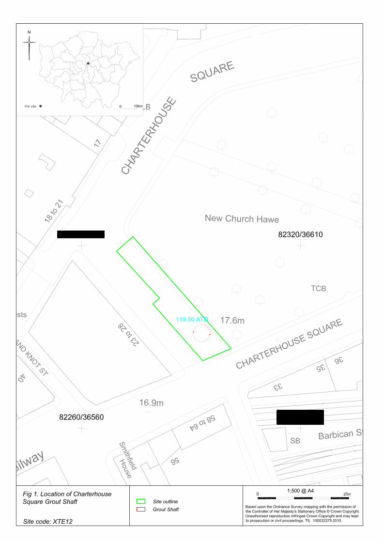
6 Annex 1 – Location of Grout shaft ......................................................................... 14
Figures (in Annex 1 at back of document)
Fig 1 Location of Grout Shaft
Fig 2 Cemetery Phase 1
Fig 3 Cemetery Phase 2
Fig 4 Cemetery Phase 3
List of Photos Photo 1, first phase of burials at 3m below ground level (bGL) photographed from street level, looking south-east. 5
Photo 2, in situ skeleton [176] and grave cut [177], the torso, arms and head remain in situ, preserved beyond the grout shaft cutting edge, looking south-west. 6
Photo 3, adult supine inhumation [188] and cut [189], looking south-west. 7
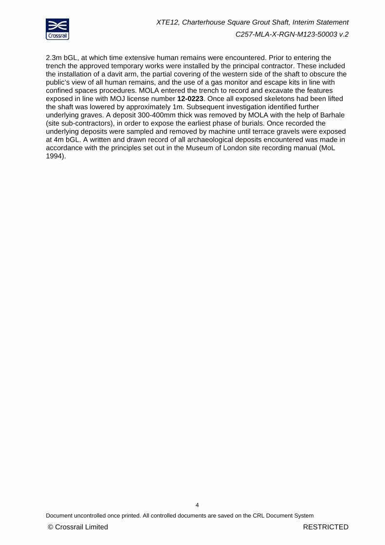
Photo 4, juvenile [197] and grave cut [198], with metal fastenings adhering to the skeleton, probably from a coffin, looking north. 8
Photo 5, adult burial [156] and grave cut [157] from phase two, truncated by double burial from phase three, looking east. 9
Photo 6, 3rd phase of cemetery, viewed from top of grout shaft, looking west 10
Photo 7, double burial [152] and [153] and cut [154] (perhaps holding hands), note disarticulated skull from phase 2 disturbed grave, looking east. 11
Photo 8, brick soakaway [96], looking north-east. 12

XTE12, Charterhouse Square Grout Shaft, Interim Statement
C257-MLA-X-RGN-M123-50003 v.2
2
Document uncontrolled once printed. All controlled documents are saved on the CRL Document System
© Crossrail Limited RESTRICTED
1 Introduction
This Interim Report covers an archaeological targeted watching brief at the location of the future Crossrail Farringdon Eastern Ticket Hall, by C257 Museum of London Archaeology (MOLA). This was carried out between 11/02/13 and 26/03/13 and supervised by MOLA Senior Archaeologist .
It was recorded under event code (sitecode) XTE12.
This document is an interim statement of the provisional results of the fieldwork. This will be followed by a Post Excavation Assessment.
The fieldwork was carried out in accordance with:
A Crossrail Site-specific Written Scheme of Investigation (SS-WSI): Farringdon Station, Site-specific Written Scheme of Investigation, Doc. No. CR-SD-FAR-EN-SY-0001 Version 6, 20.11.09
An Addendum to the WSI: Package C136 – Farringdon Station, Addendum to Written Scheme of Investigation: Detailed Excavation & Watching Brief – Eastern Ticket Hall (XTE12), Doc. No. C136-SWN-T1-XAP-M123_WS098-00001 Revision 5.0, 03.10.12 [WSI Addendum]
A Method Statement: Package C136 – Archaeological Targeted Watching Brief Charterhouse Square Grout Shaft, and General Watching Brief Smithfield Market Basement Grout Shafts Farringdon Eastern Ticket Hall (XTE12), Doc. No. C136-MLA-X-GMS-M123-50001 Revision 3.0, 11.12.12
.
2 Aims and Objectives
2.1 Research Aims
The original aims and objectives were listed in the SS- WSI Farringdon Station (Doc. No. CR-SD-FAR-EN-SY-0001, see section 1) and stated that ‘Archaeological investigation and mitigation within the Crossrail worksites for Farringdon Station have the potential to contribute to the research themes set out below’:
Evidence for burials and/or features associated with the Charterhouse burial ground may contribute to the following research aims:
Understanding life expectancy, origins and belief, seen through studying health, diet and disease, and preparing models for future research;
Considering the relationship between cemeteries and major or minor roads, in terms of symbolism, status, privacy and convenience; and
Understanding the differences, if any, between burial practices in the city and outlying cemeteries.
Archaeological remains associated with post-medieval extra-mural development may contribute to the following aim:
Contributing to our understanding of the creation of the London suburbs with direct contribution to today’s aspirations for an urban regeneration.
XTE12, Charterhouse Square Grout Shaft, Interim Statement
C257-MLA-X-RGN-M123-50003 v.2
3
Document uncontrolled once printed. All controlled documents are saved on the CRL Document System
© Crossrail Limited RESTRICTED
2.2 Fieldwork Objectives
The overall objectives of the investigation are stated in the WSI Addendum:
to mitigate the impact of Crossrail construction through a programme of archaeological works carried out in accordance with the Crossrail Generic WSI (document number CR-PN-LWS-EN-SY-00001) and the standards listed therein.
The following task-specific research questions have been devised by MOLA for this work:
2.2.1.1 Charterhouse Square
1. What is the nature and level of natural geology? Does this contrast with nearby results from Charterhouse Square (CSQ98) and earlier Crossrail work?
2. Does any brickearth survive, and if so, what does this indicate about truncation by later activity?
3. Is a palaeochannel present at this location, as suggested by borehole F30? If so, was it flowing towards the Fleet River, and what is the date and character of the channel and its fills? What do any palaeoenvironmental remains indicate about the contemporary environment?
4. What is the nature and date of any Roman extra-mural activity (e.g. farming, burials, etc)?
5. Are in situ medieval burials from the Outer Cemetery of Charterhouse, or other associated features, present? What is their date?
6. What is the character of the burials and burial practices? In particular, are they mass burials (such as plague pits) or individual burials?
7. What does the presence or absence of in situ burials indicate about the extent of this burial ground?
8. How does the height (level) of any burials compare with both the CSQ98 burial, and the redeposited material from earlier Crossrail watching briefs? What can be inferred from this?
9. If redeposited human remains are present, what can they contribute to our very limited data about this cemetery?
10. What other medieval and/or post-medieval activity is represented (e.g. quarry or refuse pits)? How does this compare with the cartographic evidence? Does any pre-date the cemetery?
11. Is butchery waste present, e.g. animal bone, particularly within medieval/post-medieval rubbish pits, following the establishment of the Smithfield livestock market? Do they reveal any atypical characteristics of animal husbandry in use during this period?
12. Is there any evidence for the destruction by bombing of the building immediately to the west during the Second World War?
3 Targeted Watching brief methodology
The grout shaft was located by the principal contractor (C435 Bam Nuttall, Ferrovial, Kier). The initial collar and shaft excavation down to 2m below ground level was undertaken under general watching brief conditions, during which MOLA maintained a basic monitoring presence to observe the works carried out. Excavation was by mechanical grabbing bucket to a depth of
XTE12, Charterhouse Square Grout Shaft, Interim Statement
C257-MLA-X-RGN-M123-50003 v.2
4
Document uncontrolled once printed. All controlled documents are saved on the CRL Document System
© Crossrail Limited RESTRICTED
2.3m bGL, at which time extensive human remains were encountered. Prior to entering the trench the approved temporary works were installed by the principal contractor. These included the installation of a davit arm, the partial covering of the western side of the shaft to obscure the public’s view of all human remains, and the use of a gas monitor and escape kits in line with confined spaces procedures. MOLA entered the trench to record and excavate the features exposed in line with MOJ license number 12-0223. Once all exposed skeletons had been lifted the shaft was lowered by approximately 1m. Subsequent investigation identified further underlying graves. A deposit 300-400mm thick was removed by MOLA with the help of Barhale (site sub-contractors), in order to expose the earliest phase of burials. Once recorded the underlying deposits were sampled and removed by machine until terrace gravels were exposed at 4m bGL. A written and drawn record of all archaeological deposits encountered was made in accordance with the principles set out in the Museum of London site recording manual (MoL 1994).

XTE12, Charterhouse Square Grout Shaft, Interim Statement
C257-MLA-X-RGN-M123-50003 v.2
5
Document uncontrolled once printed. All controlled documents are saved on the CRL Document System
© Crossrail Limited RESTRICTED
4 Provisional Results: Charterhouse Square Grout Shaft
See Fig 1 for location of grout shaft
4.1 Cemetery Phase 1
River terrace gravels deposited by the former river Fleet were recorded at 114.66m ATD. These were overlain by 0.9m thick band of sterile fine clay silt (brickearth) that was archaeologically sterile, ie there were no man made inclusions. Sealing these deposits was a 200mm band of compacted silty gravel, again apparently sterile. These deposits were recorded by MOLA’s geoarchaeological team in situ, and sampled for later analysis off site.
Cutting into the band of silty gravel were eleven individual vertically-sided graves, all sharing the same north-east–south-west alignment (atypical for medieval Christian), with heads approximately to the west (see Photo 1, Photo 2, Photo 3and Photo 4 ). Each burial was cut into the underlying deposits to a depth of between 0.2–0.4m, becoming deeper the further south, suggesting perhaps that the topology may have gently sloped down from north to south prior to its use as a cemetery.
Photo 1, first phase of burials at 3m below ground level (bGL) photographed from street level, looking south-east
The photograph above shows the layout of burials within the 4.5m diameter grout shaft. There were two distinct rows, roughly evenly spaced, with just about enough room to walk between them (possibly intentional). All skeletons were laid on their backs (supine), with limbs fully extended and hands located around the pelvic area. They were relatively well-preserved. The

XTE12, Charterhouse Square Grout Shaft, Interim Statement
C257-MLA-X-RGN-M123-50003 v.2
6
Document uncontrolled once printed. All controlled documents are saved on the CRL Document System
© Crossrail Limited RESTRICTED
westernmost row (to the right), were only partially situated within the grout shaft (see Photo 2), and only the lower limbs were recoverable.
Photo 2, in situ skeleton [176] and grave cut [177], the torso, arms and head remain in situ, preserved beyond the grout shaft cutting edge, looking south-west

XTE12, Charterhouse Square Grout Shaft, Interim Statement
C257-MLA-X-RGN-M123-50003 v.2
7
Document uncontrolled once printed. All controlled documents are saved on the CRL Document System
© Crossrail Limited RESTRICTED
Photo 3, adult supine inhumation [188] and cut [189], looking south-west
Two of the eleven skeletons [173] and [194] were only marginally within the limit of excavation, predominantly lying beyond the northern edge of the shaft. The vast majority appeared to be adult (with a single subadult), and had no obvious evidence of perimortem trauma (see Photo 3). This will be further examined in later specialist analysis. One skeleton [185] appeared to have been buried on a timber board, although this may have been the remnants of a coffin, long since decomposed.
A single subadult inhumation [197] was found in the Grout Shaft (see Photo 4). The majority of their lower limbs lay beyond the edge of the shaft; otherwise the skeletal remains were well preserved, given their fragile nature. Rusted metal fastenings adhered to the right arm and pelvis, 4 ribs had also been fused together by a single fastening, all suggesting that originally the child had been buried within a small coffin.
Pottery fragments recovered from the backfilled graves will provide us with an approximate date for when they were buried, these are currently being processed. No grave goods were found, typical of medieval burials. A selection of metal fastenings (predominantly iron nails) were found within 4 burials (181, 184,187 and 196) at least two [181] and [184] were probably buried in coffins.
In addition to the in situ skeletons, disarticulated human remains, in the form of a pelvis and some foot bones were recovered from two of the grave fills on the western side of the shaft; these may represent a single individual. Exactly how these bones came to be here, when there is no evidence for earlier truncated burials at this level will be further explored in later analysis.
XTE12, Charterhouse Square Grout Shaft, Interim Statement
C257-MLA-X-RGN-M123-50003 v.2
8
Document uncontrolled once printed. All controlled documents are saved on the CRL Document System
© Crossrail Limited RESTRICTED
Photo 4, juvenile [197] and grave cut [198], with metal fastenings adhering to the skeleton, probably from a coffin, looking north
This first phase of cemetery was covered by a single dump layer of compacted clay-silt 300–400mm thick, that is likely to have been laid on top of the newly-dug graves of the first phase, perhaps in an attempt to protect against infection? A limited quantity of pottery was recovered from this dump (provisionally dated as medieval), that provisionally appears to be of a roughly similar date to that from the underlying backfilled graves.
4.2 Cemetery Phase 2
This middle phase of burials consisted of two adult supine inhumations that shared the same north-east–south-west alignment as those from the first phase. Both had been disturbed and truncated by later grave cuts, and were located in the south-western part of the grout shaft. One appeared to have partially slumped into the grave below it, and had had its legs truncated. The other (see Photo 5) was missing its skull and jaw, that had been truncated by a double burial immediately above it from the third phase of cemetery (see Photo 7). A skull (minus mandible-jaw) had been previously found loose within the grave fill of this double burial, and may well belong to the truncated skeleton.

XTE12, Charterhouse Square Grout Shaft, Interim Statement
C257-MLA-X-RGN-M123-50003 v.2
9
Document uncontrolled once printed. All controlled documents are saved on the CRL Document System
© Crossrail Limited RESTRICTED
Photo 5, adult burial [156] and grave cut [157] from phase two, truncated by double burial from phase three, looking east
These two graves represent the intermediate phase of cemetery activity on site, they share the same alignment to those from phase one. This may suggest that either the alignment of the earlier graves was still evident, and reproduced, or that there was an unknown feature (boundary wall or ditch for example) that dictated the north-east–south-west burial alignment at this period (pottery dating may help to suggest which). In whichever case, either sufficient time had elapsed between the second and third phases of burials for the exact location of the former to not be evident, or the graves were unmarked.
4.3 Cemetery Phase 3
This final phase of activity included 12 individuals all appearing to be adult, and were orientated east–west at an average depth of 115.00m ATD (see Photo 6). These shared similar characteristics to the earlier phases, ie all were laid on their back, with limbs extended, and hands generally located over or next to the pelvis, and with no grave goods. There were two graves with multiple burials, one with two adults side by side [154] (see Photo 7), and a second with two stacked together [168]. The latter burial, unfortunately located on the very edge of the northern limit of excavation, is the only indicator suggesting pressures of time and/or space on the disposal of remains during this phase of cemetery. Copper alloy pins were recovered within the immediate vicinity of three of the burials, these may be shroud pins, one located near the left ear of a (potentially female) skeleton might instead be a hair pin.

XTE12, Charterhouse Square Grout Shaft, Interim Statement
C257-MLA-X-RGN-M123-50003 v.2
10
Document uncontrolled once printed. All controlled documents are saved on the CRL Document System
© Crossrail Limited RESTRICTED
Photo 6, 3rd phase of cemetery, viewed from top of grout shaft, looking west
One double grave contained two adults [154] (see Photo 7), both laid on their back, with heads facing south. Their corresponding right and left hands appear to be co-located, as if they were clasped together (possibly holding hands) although this may be coincidence. This much larger grave appears to have been dug intentionally for these specific individuals; the most likely interpretation is that they were related in some way (eg by blood or marriage). Interestingly the next grave to the north in this final phase of burials was of similar dimensions, but only contained a single skeleton.
It would appear that at least two of these graves [144] and [154] were backfilled soon after they were excavated, with the same soil, as the disturbed bones probably originating from the earlier burials were found within the backfilled graves. This may suggest that the graves were excavated one at a time, either at periods of low mortality from the plague, or that they post-dated it. Hopefully further analysis and dating will help us to better understand the date and process at work during this phase of cemetery.

XTE12, Charterhouse Square Grout Shaft, Interim Statement
C257-MLA-X-RGN-M123-50003 v.2
11
Document uncontrolled once printed. All controlled documents are saved on the CRL Document System
© Crossrail Limited RESTRICTED
Photo 7, double burial [152] and [153] and cut [154] (perhaps holding hands), note disarticulated skull from phase 2 disturbed grave, looking east
Pottery sherds were recovered from all of the grave fills. Four were provisionally dated during the fieldwork to AD 1270–1350. If not residual, this would imply that these are likely to be associated with the plague outbreak of 1348/49. If so, and given that they are the latest of the three phases, they would then represent the later victims of the Black Death, or possibly the Pestis Secunda of 1361.
However, dating and analysis of the pottery and stratigraphy will be conducted following this interim statement, taking into account the sequence and specific circumstances of rapidly excavated and backfilled grave fills (which may only be rapidly backfilled with spoil from digging the grave, and thus pottery might only pre-date the burial).
Therefore, this latest phase may alternatively represent the earliest burials from the outer cemetery of Charterhouse, which documentary sources record post-dated the Black Death by at least twenty years.
4.4 Post-medieval Dumping
A series of horizontal dumped deposits overlay the latest cemetery phase, the earliest at approximately 2m bGL, and contained large fragments of pottery, provisionally dated AD 1600–1800. It is difficult to ascertain the exact circumstances that lead to the deposition of this horizon, although it is perhaps significant that no residual human remains were recovered, unlike deposits seen in utilities diversions and associated enabling works, also undertaken for Crossrail, in the immediate vicinity. It may be that any later burial horizons have been entirely truncated by such later post-medieval activity, or simply that there were no later burials in this
XTE12, Charterhouse Square Grout Shaft, Interim Statement
C257-MLA-X-RGN-M123-50003 v.2
12
Document uncontrolled once printed. All controlled documents are saved on the CRL Document System
© Crossrail Limited RESTRICTED
location. It should be emphasised that the grout shaft is only 4.5m in diameter, and allows us a limited glimpse of the archaeological sequence, which may or may not reflect the surrounding stratigraphy.
4.5 Trial pits and boreholes
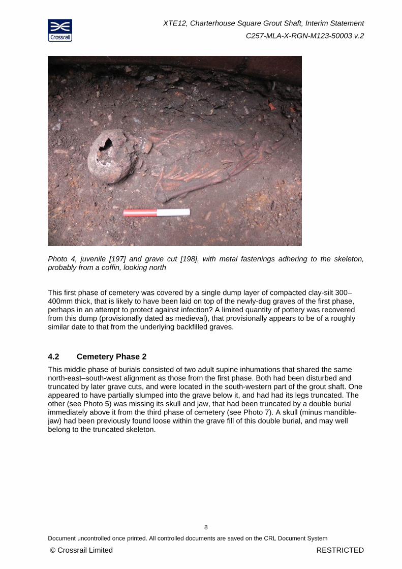
Fifteen trial holes (for the hoarding fence posts) and three boreholes were monitored under general watching brief conditions in advance of the grout shaft works. A single fragment of glazed medieval tile was recovered ,residually deposited in a later post-medieval dump layer. All deposits dated to the post-medieval period, and were limited to levelling, dump (with frequent inclusions of pottery, [glazed] tile and clay pipe) and demo layers immediately beneath the cobbled road surface. A variety of 18th/19th-century masonry structures were uncovered, including a floor and a probable wall footing in the north of the compound, most likely relating to terraced houses to the west (now demolished), and a soakaway aligned NE–SW (Photo 8) located in the south-east of the compound, a possible indicator of the street alignment prior to construction of the Metropolitan line in the 1860s. A succession of heavily rooted garden soil deposits along the eastern perimeter are evidence of build-up related to the modern gardens in Charterhouse Square immediately to the east.
The borehole results were of limited value, as they gave no suggestion of the presence of the cemetery. An earlier borehole, located in the area of the grout shaft, implied that a paleochannel was located immediately above the natural sands and gravels, this was subsequently proved incorrect. These results, and their association with those from the grout shaft, if any, will be further explored in post excavation analysis.
Photo 8, brick soakaway [96], looking north-east

XTE12, Charterhouse Square Grout Shaft, Interim Statement
C257-MLA-X-RGN-M123-50003 v.2
13
Document uncontrolled once printed. All controlled documents are saved on the CRL Document System
© Crossrail Limited RESTRICTED
5 Importance of Resources
The post-medieval deposits are assessed as being of low importance, and the related finds are typical of those found within 18th to 19th-century deposits. The burials are provisionally assessed as being of high importance as some (possibly all) are probably associated with the Black Death of 1348–9, and have potential to contribute to recent groundbreaking academic studies of Yersinia Pestis. Conversely, the third, and perhaps second, phases of burials may relate to later medieval epidemics or burials. There is no evidence to suggest that monastic graves (post-1370) from the Outer Cemetery of Charterhouse would have been buried within the modern confines of Charterhouse Square. Current thinking is that monastic burials lie solely within the main precinct of Charterhouse (to the north) and that Charterhouse Square was used, if at all, for non-religious personnel.
5.1 Provisional conclusions for future work
No further archaeological work is planned on this sub-site
A Survey Report, Summary report and post-excavation assessment are required.
It is hoped that following the processing, assessment and subsequent analysis of the skeletons, scientific tests (DNA, isotope analysis and possibly carbon dating) will help to confirm that Yersinia pestis (as is now widely believed) was indeed the causative agent of this outbreak of plague, and may allow us to identify the specific genetic branch that was responsible. Also full analysis of the finds (particularly pottery) may help us to better understand the differences in burial alignments between the phases of cemetery. These questions will be considered in greater detail during post-excavation assessment and analysis.

XTE12, Charterhouse Square Grout Shaft, Interim Statement
C257-MLA-X-RGN-M123-50003 v.2
14
Document uncontrolled once printed. All controlled documents are saved on the CRL Document System
© Crossrail Limited RESTRICTED
6 Annex 1 – Figures
Fig 1 Location of Charterhouse Square Grout Shaft
Fig 2 Phase 1 NE–SW aligned grave cuts from medieval cemetery
Fig 3 Phase 2 NE–SW aligned grave cuts from medieval cemetery
Fig 4 Phase 3 E–W aligned grave cuts from medieval cemetery