XPOSED OIL POLLUTIONceds.org/audit/ES=P_Guidance.pdf · means pollution of the nearest waterway...
18
ES=P EXPOSED SOIL = POLLUTION How You Can Save 100 Feet of Chesapeake Bay Tributaries in an Hour by Halting Construction Site Mud Pollution Prepared By Richard Klein COMMUNITY & ENVIRONMENTAL DEFENSE SERVICES 811 Crystal Palace Court Owings Mills, Maryland 21117 410-654-3021 [email protected] ceds.org/esp November 13, 2012
Transcript of XPOSED OIL POLLUTIONceds.org/audit/ES=P_Guidance.pdf · means pollution of the nearest waterway...

ES=P
EXPOSED SOIL = POLLUTIONHow You Can Save 100 Feet of Chesapeake Bay Tributaries inan Hour by Halting Construction Site Mud Pollution
Prepared ByRichard Klein
COMMUNITY & ENVIRONMENTAL DEFENSE SERVICES
811 Crystal Palace CourtOwings Mills, Maryland 21117
ceds.org/esp
November 13, 2012

CONTENTS
INTRODUCTION . . . . . . . . . . . . . . . . . . . . . . . . . . . . . . . . . . . . . . . . . . . . . . . . . . . . . . . . . . . . . 1
WHY DOES EXPOSED SOIL = POLLUTION? . . . . . . . . . . . . . . . . . . . . . . . . . . . . . . . . . . . . . 3
EROSION CONTROL VERY COST EFFECTIVE . . . . . . . . . . . . . . . . . . . . . . . . . . . . . . . . . . . 4
HOW EROSION & SEDIMENT CONTROL WORKS . . . . . . . . . . . . . . . . . . . . . . . . . . . . . . . . 5
LAWS & INSPECTION AGENCIES . . . . . . . . . . . . . . . . . . . . . . . . . . . . . . . . . . . . . . . . . . . . . . 7Delaware . . . . . . . . . . . . . . . . . . . . . . . . . . . . . . . . . . . . . . . . . . . . . . . . . . . . . . . . . . . . . . 7District of Columbia . . . . . . . . . . . . . . . . . . . . . . . . . . . . . . . . . . . . . . . . . . . . . . . . . . . . . 7Maryland . . . . . . . . . . . . . . . . . . . . . . . . . . . . . . . . . . . . . . . . . . . . . . . . . . . . . . . . . . . . . . 7New York . . . . . . . . . . . . . . . . . . . . . . . . . . . . . . . . . . . . . . . . . . . . . . . . . . . . . . . . . . . . . . 8Pennsylvania . . . . . . . . . . . . . . . . . . . . . . . . . . . . . . . . . . . . . . . . . . . . . . . . . . . . . . . . . . . 8Virginia . . . . . . . . . . . . . . . . . . . . . . . . . . . . . . . . . . . . . . . . . . . . . . . . . . . . . . . . . . . . . . . 8West Virginia: . . . . . . . . . . . . . . . . . . . . . . . . . . . . . . . . . . . . . . . . . . . . . . . . . . . . . . . . . . 9
HOW YOUR EFFORTS WILL HELP CURB MUD POLLUTION . . . . . . . . . . . . . . . . . . . . . . . 9
HOW TO EVALUATE A CONSTRUCTION SITE & COMPLETE THE CHECKLIST . . . . . 10
1 Fox, H.L. 1974. Effects of Urbanization on the Patuxent River: With Special Emphasis on SedimentTransport, Storage and Migration. Thesis (Ph. D.)--Johns Hopkins University, 1975.
1
THE ESSENCE OF THIS PUBLICATION IS SIMPLE...
As long as exposed soil exists on a construction site, pollution of downstreamwaters will occur even if the site has silt fence and other perimeter controls.
WHAT TO LOOK FOR IS EQUALLY SIMPLE...
When initial earth-moving has ceased on a construction site, all exposed soilmust be completely mulched & seeded. A dense growth of grass should
appear in five to eight weeks (March-October).
YOU CAN SAVE 100 FEET OF DOWNSTREAM WATERS PER HOUR BY...
Informing inspection agencies of sites needing better stabilization andproviding the agencies with the public support essential to effective
enforcement.
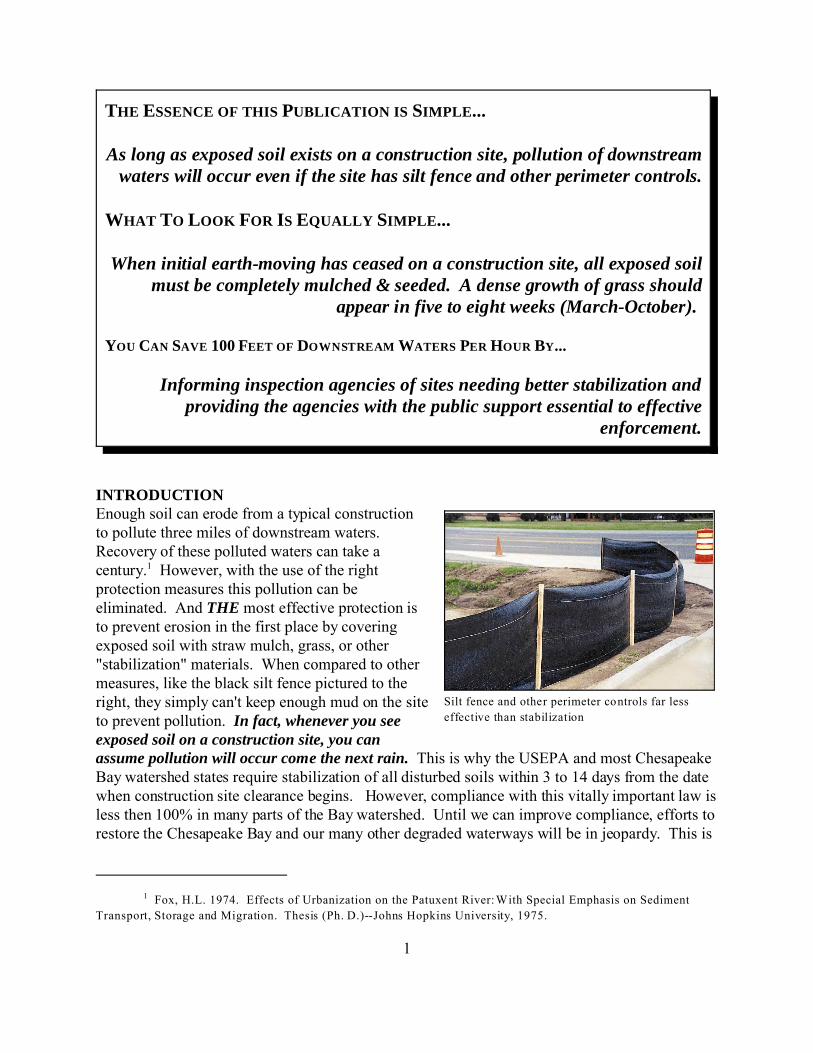
Silt fence and other perimeter controls far lesseffective than stabilization
INTRODUCTIONEnough soil can erode from a typical constructionto pollute three miles of downstream waters. Recovery of these polluted waters can take acentury.1 However, with the use of the rightprotection measures this pollution can beeliminated. And THE most effective protection isto prevent erosion in the first place by coveringexposed soil with straw mulch, grass, or other"stabilization" materials. When compared to othermeasures, like the black silt fence pictured to theright, they simply can't keep enough mud on the siteto prevent pollution. In fact, whenever you seeexposed soil on a construction site, you canassume pollution will occur come the next rain. This is why the USEPA and most ChesapeakeBay watershed states require stabilization of all disturbed soils within 3 to 14 days from the datewhen construction site clearance begins. However, compliance with this vitally important law isless then 100% in many parts of the Bay watershed. Until we can improve compliance, efforts torestore the Chesapeake Bay and our many other degraded waterways will be in jeopardy. This is
2
where you come in and how you can save a hundred feet of waterway with just an hour of yourtime.
We want to inform all Bay watershed residents that exposed soil on a construction sitemeans pollution of the nearest waterway come the next rain. Our goal is to get people to react toexposed construction site soil with the same concern triggered by littering or aggressive driving. As this perception spreads we believe the extent of exposed construction site soil will diminishthrough voluntary actions on the part of the development and construction community.
This publication is intended to help volunteers and other watershed advocates identifyconstruction sites that could benefit from greater use of stabilization measures. Theidentification is done from roads, parking lots and other public areas in view of a site. There isno need to trespass onto a construction site. In fact, we implore you not to trespass.
The advocate would then notify an inspection agency of the opportunity to enhanceprotection of local waters and the Bay by reducing exposed soil through stabilization measures. Advice for identifying the agency covering your area is provided later in this publication, in thesection headed Laws & Inspection Agencies.
We realize some folks may find these notifications intimidating. As explained in the nextparagraph, your findings can still serve a very important purpose even if you opt not to notify theinspection agency.
At the end of this publication you will find a Watershed Advocates Construction ES=PChecklist. Use the paper version of the checklist to record your findings while observing aconstruction site. Once you have access to a computer, add your findings to the WatershedAdvocates Construction ES=P Database at: ceds.org/espreport. Please do not mail the paperforms to us. Again, simply adding your findings to the database will help considerably, even ifyou don’t take further action.
How does this help?
Well, we hope the database will contain enough information to allow Chesapeake Bayadvocacy groups to identify those counties, towns, cities and even states doing particularly wellat minimizing exposed construction site soils. These jurisdictions would be commended for theirsuccess. We also hope the database will contain the information needed to commenddevelopment companies for making full use of stabilization measures.
The database will also allow Chesapeake Bay advocacy groups to identify those localitieswhere stabilization is not being used to full effectiveness. The groups would then exploreoptions for providing the localities with the public support essential to improve effectiveness.
Some folks are fine evaluating construction sites on their own. Others prefer to work aspart of a group. Either option works.

3
Sediment traps capture sand, some silt butlittle clay
If you are a loner then this publication provides all the background needed to get started. We think you’ll find the evaluation procedures both simple and straight-forward.
For watershed organizations and others who prefer to work in groups, we can schedule atwo-hour Saturday morning training session in your area. After a half-hour presentation followedby discussion we’ll look at several active construction sites near the training location. After thesession you’ll be able to evaluate sites on your own. But its likely you’ll meet others at thetraining session with whom you can form a team. We can help you divide the watershed up intoareas covered by specific teams.
So, how does all this allow you to save a hundred feet of waterway for each hour youvolunteer to this effort? Well, we figure it’ll take you no more then an hour to evaluate a site andreport your findings. We also figure that for each hour invested you will make it possible to winstabilization of enough exposed construction site soil to save an average of a hundred feet ofdownstream waters.
WHY DOES EXPOSED SOIL = POLLUTION?The answer to this question is simple: Clay.
Soil is made up of three particle sizes: sand, silt and clay. Clay is the smallest and thehardest to remove once it has been eroded from the soil surface and entrained in runoff. Onemight think that the small size renders clay particles harmless. In some respects the opposite istrue. Much of the phosphorus, pesticides, and other pollutants washing from construction sitestravel attached to clay particles. Many fish eggs have a slightly sticky coating and clay canadhere so thickly to the egg surface that oxygen flow is blocked suffocating the developing fishembryo. Clay is the most expensive particle to remove from drinking water sources. Clay andother suspended particles are responsible for a large portion of the turbidity which blockssunlight and has greatly diminished the extent of submerged aquatic vegetation (SAV)throughout the Chesapeake Bay and other Maryland waters.
Sand and coarse silt can be kept on aconstruction site with silt fence, sediment traps (likethat pictured to the right) and other perimeter controlmeasures. These perimeter measures mostly rely uponsettling to remove sediment from runoff. The largerparticles settle fairly quickly while days or weeks maybe required for clay and finer silts to settle fromsuspension. So, the most effective way of keeping clayon a construction site is to prevent erosion, whichmeans minimizing the exposure of soil to the erosiveforce of rainfall and runoff. This, in turn, meansprotecting soil as quickly as possible followingdisturbance with a layer of straw mulch, then grass.

2 These erosion rates are based upon the Chesapeake Bay Watershed Phase 5 .3 Model available online at:http://ches.communitymodeling.org/models/CBPhase5/index.php
3 See: http://cfpub.epa.gov/npdes/stormwater/menuofbmps/index.cfm?action=browse&Rbutton=detail&bmp=41&minmeasure=4
4 See: http://cfpub.epa.gov/npdes/stormwater/menuofbmps/index.cfm?action=min_measure&min_measure_id=4
5 See: http://www.dnr.state.md.us/irc/docs/00006468.pdf
6 See: ftp://ftp-fc.sc.egov.usda.gov/Economics/recreate/WQeconforBradk.pdf
7 See: http://ceds.org/audit/Urbanization_and_Streams-Studies_of_Hydrologic_Impacts.pdf
8 See: http://www.ndc.iwr.usace.army.mil//dredge/dd10cos2.htm
4
Road beds and parking lot areas are protected by laying down a layer of stone. Collectively,mulch, grass and stone are known as “stabilization measures”.
Generally, perimeter silt fence and traps can retain 30% to 50% of eroded soil on theconstruction site whereas mulch, grass and other stabilization measures reduce erosion (andoffsite sediment pollution) by 90% to 99%!
EROSION CONTROL VERY COST EFFECTIVEIt’s no coincidence that all the Chesapeake Bay watershed jurisdictions require rapid use ofstabilization measures. Erosion control is one of the most cost-effective pollution controlprograms we have. For example, in Maryland an unprotected construction site might erode at arate of 40 tons/acre/year, which is a hundred times the rate for cropland, and a thousand timesthat of forest.2 It costs $800 to $1500 to apply mulch and grass seed to an acre of constructionsite.3 These practices reduce erosion by 90% to 99%.4 So, assuming a typical construction site isactive for a year, mulch and seeding would keep 36- to 39-tons of sediment on each acre at a costof $20 to $42 per ton.
Now let’s take a look at the damages each ton of sediment might cause.
Maryland has 470 miles of trout streams5, each mile of which adds about $35,000 peryear to the state and local economy.6 A single 20-acre construction site could destroy three milesof trout stream for a decade to a century.7 That would work out to an economic loss of at least$1.1 million. It would cost $25,000 to apply erosion control measures which would keep 780tons of sediment out of the trout stream. So the ratio of cost to benefit would be 1:42 ($25,000cost:$1,050,000 benefit).
But the benefits don’t end at the mouth of the trout stream. Eventually each ton ofsediment deposited in the trout stream would travel downstream causing additional damages. Ifthe sediment came to rest in a navigable channel the removal cost would be $6 to $28 per ton.8

9 See: http://www.columbiaassociation.com/pdfs/getinvolved/Dredging200703.pdf
5
The cost to remove sediment from Columbia, MD lakes runs around $175 per ton.9 These costsfurther increase the benefits of preventing erosion.
Additional benefits would come from reduced water treatment costs, other recreationaland commercial fisheries preserved, enhanced waterfront property value, and on the list could go. So, as we said, erosion control is one of our most cost effective pollution control strategies. Thetrue cost to benefits ratio could be as high as $100 saved for each dollar spent.
HOW EROSION & SEDIMENT CONTROL WORKSNow that you know why stabilization is so important, let’s take a moment to look at the basics oferosion and sediment control as applied to construction sites. On the next page you’ll find aseries of illustrations showing how site development progresses and the type of measures used tominimize erosion and trap eroded soil (sediment) at the site perimeter.
Initially, a narrow swath is cleared along the downhill edge of the site. The swath is justwide enough to install measures like silt fence, a swale (ditch) or dike (ridge of earth) to capturerunoff from exposed soils further uphill. These measures then carry the runoff to a sediment trap(small pond) or a sediment basin (large pond). Once these perimeter controls are completed allsoil surfaces are mulched and seeded.
Now that perimeter controls are in place the remainder of the site can be cleared ofvegetation. On many sites some earth-moving is needed to create the relatively level areasrequired to erect buildings and to accommodate roads. The site should quickly be brought up tothe point where both road and building construction can begin. This point is called rough grade. Once rough grade is reached earth-moving usually stops for a period of weeks or months untildevelopment is near completion and fine or final grading is performed.
When rough grade is reached all areas outside of road beds and parking lots should bemulched and seeded. A layer of stone should be laid down on road and parking lot beds. Themulch, seed and stone are all forms of stabilization, which reduces soil erosion by 90% to 99%. Perimeter measures such as silt fence, sediment traps and basins can only retain a third to half theeroded soil onsite. The rest flows into nearby waterways causing sediment pollution.
To understand how erosion and sediment control works think in terms of major storms,not weekly rains. During, say, the worse storm in a normal two-year period, large volumes ofrunoff flows from exposed soils. The volume is far less from stabilized soils. The high velocityof runoff from exposed soils can quickly cause muddy flows to overtop perimeter silt fence. Sediment deposited in traps and even basins can be resuspended and discharged into nearbywaterways. This is why perimeter controls are less effective than one might imagine.

1 Site Prior To Disturbance 4 Remainder of Site Cleared
3 Perimeter Controls Installed
2 Perimeter Swath Cleared 5 Earth-Moving Brings Site To Rough Grade
6 Rough Grade Reached - All Soil Stabilized
Perimeter Sediment Trap
Perimeter Swale With Silt Fence on Dike Top
Site At Rough Grade
Hydroseeding: Applies Mulch, Grass Seed,Fertilizer & Water; Dense Growth in 4-6 Weeks
HOW EROSION & SEDIMENT CONTROL WORKS
7
Mulch needs to be thick enough so underlying soils cannot be seen. Grass seedlingsshould sprout within ten days or so during the planting season (March - October). Any areaswith sparse seedling growth should be reseeded. If rain has been uncommon then irrigation maybe required. By four to six weeks following seeding, a dense growth of grass should be present. In Pennsylvania grass must cover a minimum of 70% of the soil. After January 9, 2013,Maryland requires a minimum 95% vegetative cover. If four to six weeks have elapsed yetvegetative cover is sparse, then additional treatments are required. You should notify theappropriate inspection agency of the stabilization deficiency (see next section for agency contactinformation).
LAWS & INSPECTION AGENCIESFollowing is the law adopted by the Bay watershed states requiring stabilization of exposedconstruction site soils along with a description of how to contact inspection agencies in eachstate. As you will see, all require essentially the same thing. Once a site reaches rough grade orremains idle for more than a few weeks, all exposed soils must be stabilized.
Delaware: The Delaware Sediment & Stormwater Regulations (Title 7, Section 5101) require:
All plans shall include details of temporary and permanent stabilization measuresincluding placement of the following statement on all plans submitted for approval.Following soil disturbance or redisturbance, permanent or temporary stabilization shallbe completed within 14 calendar days as to the surface of all perimeter sedimentcontrols, topsoil stockpiles, and all other disturbed or graded areas on the project site.
Sediment control inspection rests mostly with the local government. For contact information see:http://www.dnrec.delaware.gov/swc/Drainage/Pages/DelegatedAgencies.aspx
District of Columbia: Section 538 Guidelines for Erosion and Sedimentation Control states:
(k) Establish temporary cover by seeding or mulching graded areas except streetsand parking areas where underground utilities are planned which may otherwisebe exposed for a period greater than thirty (30) days before permanentstabilization can be achieved. This practice should be accomplished as soon asrough grading work is done; and
(l) Stabilize all streets and parking areas, within thirty (30) days of final grading,with base course crushed stone.
The District’s Inspection and Enforcement Branch is responsible for construction site sedimentcontrol: http://ddoe.dc.gov/service/construction-site-inspections
Maryland: The Code of Maryland Regulations (COMAR 26.12.17.01.07B(3)(e)(iv)) states:

10 See: http://www.mde.state.md.us/programs/Water/StormwaterManagementProgram/SoilErosionandSedimentControl/Pages/programs/waterprograms/sedimentandstormwater/erosionsedimentcontrol/index.aspx
8
Following initial soil disturbance or redisturbance, permanent or temporary stabilizationshall be completed within three calendar days as to the surface of all perimeter controls,dikes, swales, ditches, perimeter slopes, and all slopes greater than 3 horizontal to 1vertical (3:1); and seven days as to all other disturbed or graded areas on the projectsite.
Local government agencies enforce erosion and sediment control laws in 14 of Maryland's 23 countiesand in eight of the larger cities. Phone numbers for these local enforcement agencies are provided at the bottom of the following Maryland Department of the Environment (MDE) webpage: Erosion and Sediment Control in Maryland.10 For all other locations in Maryland call MDE at: Week Days (410) 537-3510 or Nights/Weekends 1-866-633-4686.
New York: Section 2, of the New York Standards and Specifications for Erosion and SedimentControl, states:
Where land disturbance is necessary, temporary seeding or mulching must be used onareas which will be exposed for more than 14 days.
Contact the Department of Environmental Conservation regional office for your area:http://www.dec.ny.gov/about/558.html
Pennsylvania: Title 25, Section 102.22(b), of the Pennsylvania Code states:
Upon temporary cessation of an earth disturbance activity or any stage or phase of anactivity where a cessation of earth disturbance activities will exceed 4 days, the site shallbe immediately seeded, mulched, or otherwise protected from accelerated erosion andsedimentation pending future earth disturbance activities.
In Pennsylvania, construction site erosion and sediment control enforcement rests with the localSoil Conservation District or the Department of Environmental Protection (DEP) regional office. To locate the District serving your area go to: http://pacd.org/your-district/find-your-district/
To find the nearest DEP Regional Office go to: www.portal.state.pa.us/portal/server.pt/community/about_dep/13464/office_locations/585263
Virginia: Regulation 4VAC50-30-40, of the Virginia Code states:

9
Permanent or temporary soil stabilization shall be applied to denuded areas within sevendays after final grade is reached on any portion of the site. Temporary soil stabilizationshall be applied within seven days to denuded areas that may not be at final grade butwill remain dormant for longer than 30 days. Permanent stabilization shall be applied toareas that are to be left dormant for more than one year.
Virginia is about to lower the 30-day threshold to 14 days. Erosion and sediment controlenforcement rests with 166 local county, city or town programs. To determine the enforcementagency for your area contact the Virginia Department of Conservation and Recreation Division ofSoil and Water office for your region: http://www.dcr.virginia.gov/stormwater_management/swintro.shtml#regional.
West Virginia: Section 3.10 Temporary Seeding, of the West Virginia Erosion and SedimentControl Best Management Practice Manual the states:
Use this method [temporary seeding] where exposed soil surfaces are not to befine-graded for periods longer than 21 days. Such areas include denuded areas, soilstockpiles, dikes, dams, sides of sediment basins, temporary road banks, etc.
To report a problem at a construction site contact Environmental Enforcement at the WVDepartment of Environmental Protection Romney office: 304-822-7266.
HOW YOUR EFFORTS WILL HELP CURB MUD POLLUTIONBy calling attention to opportunities for protecting exposed soil, your efforts will help to reduceconstruction site mud pollution in several very important ways.
First, in these tight budgetary times many inspection agencies lack the personnel to visitconstruction sites at the frequency needed to maintain a high level of compliance. Notifying theagency of sites with significant violations will help them focus limited staff resources on thosesites with serious problems. This may alert the agency to sites requiring attention which otherwise might not be noted for days or weeks or the next big storm!
Second, we hope to instill the concept of Exposed Soil = Pollution in the general public. If this goal is achieved then exposed soil on a construction site may become just as politicallyincorrect as other taboos, like junk cars on lawns, burning leaves, or aggressive driving. Evenpartial success towards this goal may motivate far greater voluntary compliance then presentlyoccurs. The more people reporting exposed soil, the more rapidly we'll reach a threshold wherevoluntary compliance accelerates.
Third, by adding your findings to the Watershed Advocates Construction ES=PDatabase, Chesapeake Bay advocacy groups will be able to monitor how well specific counties(townships and cities) are doing in complying with soil stabilization laws. By combining yourreports with others we can identify those areas where additional public support is needed to helpthe inspection agency achieve a higher level of compliance.

10
In the remainder of this publication we’ll describe each of the very simple steps in evaluating a site for compliance with stabilization requirements.
HOW TO EVALUATE A CONSTRUCTION SITE & COMPLETE THE CHECKLISTIn this section we'll walk you through each of the questions presented in the WatershedAdvocates Construction ES=P Database Checklist, which you’llfind at the end of this document
1. Construction Site Information: Please provide as much ofthe following information as you can.
a. Name of Construction Site: Usually found on a sign, likethat to the right, near the main entrance to the site.
b. Company Developing Site: Also may be found on a signnear the site entrance. Chesapeake Bay advocacy groupsmay wish to commend a company which consistently hasgood stabilization on their sites.
c. Company Contact Info: Again, this information may befound on a sign at the site entrance. Note any of the following given on the sign:mailing address, phone number, e-mail, web address, or contact person.
d. City/Town: The borough, township, city, or postal zone in which the construction siteis located.
e. County: Please note the county in which the site is located.
A principal use of these reports will be to identify cities, townships or counties deservingrecognition for a job well done and where greater public support is needed to enhancecompliance with water quality protection laws. This is why we ask for city, town and countyinfo.
f. State: The state in which the construction site is located.
g. Photo Numbers: If you’re using a digital camera then notes the number range for thephotos taken. Occassionally we will ask you to forward the photos to us, but they aremostly for your records.
h. Evaluation Date: The date you visited the site.
2. Location: Since most sites lack a street address, a detailed and precise description of thesite location is critical. For example, describe the location with something like: On thenorth side of Main Street, 1/4 mile east of First Avenue or NW corner of Main & First. If
11
your cell phone or car has a gps function then please note the site coordinates.
3. Could we get your contact information: We ask for this information in case we havequestions and so we can provide you with an update on what your report and that of othershas accomplished. Your e-mail address is particularly important. Its far easier tocommunicate by e-mail than phone or snail-mail. Also, if we have your e-mail address wecan forward summaries and other reports regarding the survey.
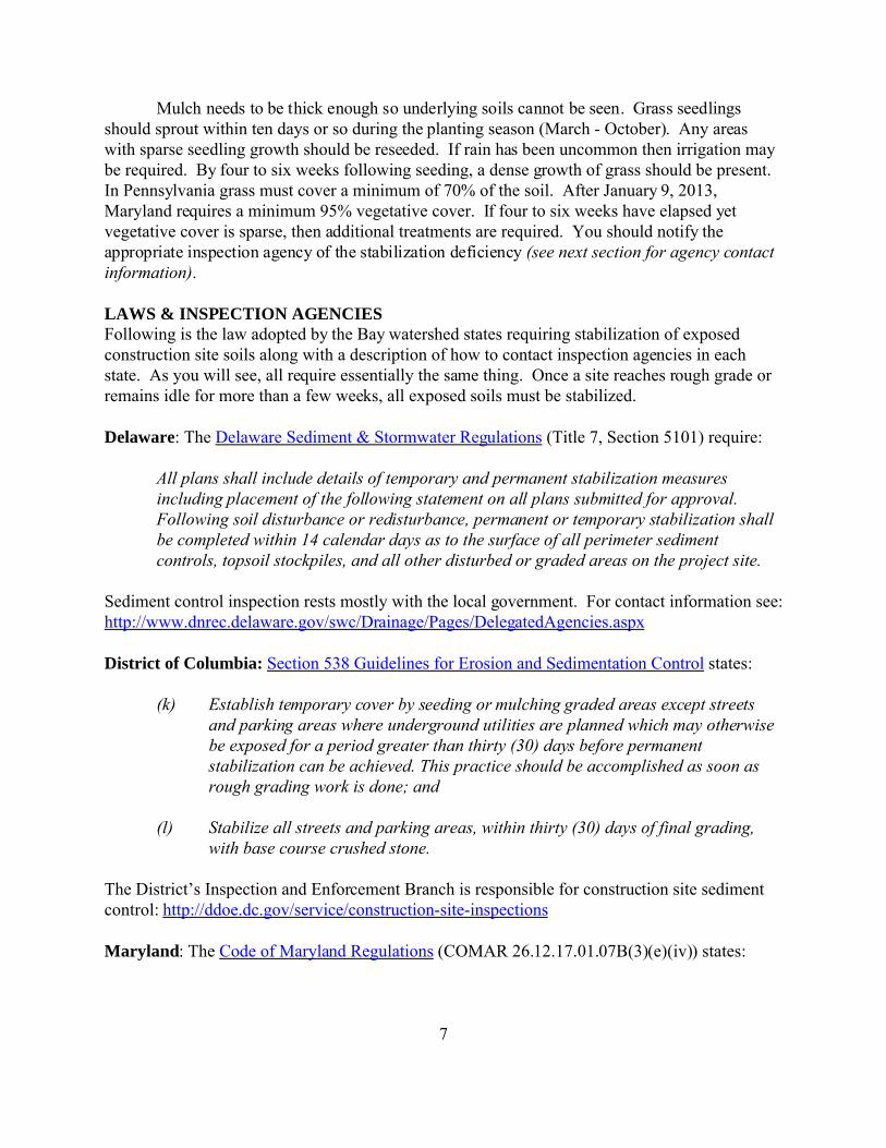
4. What is the area of the site: By area wemean how much land the site covers. By sitewe mean all that area which was originallycleared of vegetation when construction firstbegan. Usually the outer boundary is markedby mature trees and other undisturbedvegetation. In the photo to the right, a reddashed line runs along the outer limits ofdisturbance. In this case the site is all that landwithin the red boundary.
For large sites you can usually measure at least one side using your car odometer. Smaller sites can be a bit more challenging, but following are several estimationtechniques. First, we prefer expressing site area in acres (209 ft x 209 ft) but you could alsouse dimensions (feet by feet) or any other units you prefer. Many of us find it easier toestimate dimensions by using a familiar reference, like the number of NFL football fields(360 ft x 160 ft or 1.3-acres) that could fit on the site or Walmart Supercenters (2.5 acres). Some people find it easier to use the width of their yard. You can also use online aerialphotos, like Google Earth, Bing, etc. Though the photo will likely predate site clearanceyou can usually figure out the site boundaries. The online measuring tools then make itpossible to compute site area.
5. What portion of the site can be seen from public areas (without trespassing): When youfirst come across a site you may not know how much is visible from public areas. Butwhen you consult aerial photos later you can probably make a guesstimate of this. However, if you simply don’t know then leave the percentage blank.
6. Of the originally disturbed area, what percentage is completed with buildingfoundations, streets, parking lots, lawns and other landscaped areas: Of the area youcan see, how much has progressed to the point where temporary stabilization is no longerneeded? In other words, what percentage of the site contains [partial or fully] completedbuildings, building foundations, paved streets or parking lots, permanent lawns or otherlandscaping?
7. What percentage of the incomplete portion of the site is (see four options below): Byincomplete, we mean all those areas of the site that lack the features listed in Question #6,

12
Of the area visible in this photo, about 70% is exposed soil
Same site as above, but 0% exposed soil. All disturbed soils have been covered with a layerof mulch thick enough to obscure underlying soils
above.
What percentage of the incomplete portion of the site is:
a. Fully exposed soil percent: While viewing a site from adjoining public areas, whatpercentage of the incomplete area consists of exposed soil? Soils are NOT fullyexposed if they are covered by any mulch, grass or stone; even a little.
What percentage of the incomplete portion of the site...
b. Has some mulch, grass or other stabilization, but underlying soils are still visible: It appears that the budget for many construction sites covers the cost for just onetreatment of mulch, grass seed, fertilizer and irrigation water. In some cases onetreatment is all that is needed to achieve a dense growth of grass. In others, two or threetreatments are required to achieve good stabilization. On the next page are two photos. The photo on the left shows what a good layer of mulch looks like. At an applicationrate of two- to three-tons per acre, the mulch totally obscures underlying soils from
13
About 75% Vegetative Cover
³ Good Stabilization
Straw mulch completelyblankets underlying soilfrom view.
Poor Stabilization ºSoil still visible through
the sparse grass andmulch.
About 30% Vegetative Cover
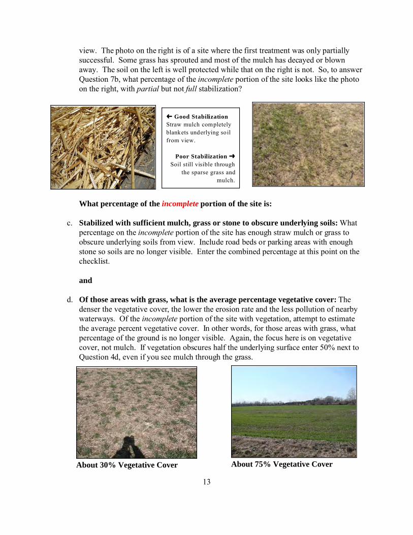
view. The photo on the right is of a site where the first treatment was only partiallysuccessful. Some grass has sprouted and most of the mulch has decayed or blownaway. The soil on the left is well protected while that on the right is not. So, to answerQuestion 7b, what percentage of the incomplete portion of the site looks like the photoon the right, with partial but not full stabilization?
What percentage of the incomplete portion of the site is:
c. Stabilized with sufficient mulch, grass or stone to obscure underlying soils: Whatpercentage on the incomplete portion of the site has enough straw mulch or grass toobscure underlying soils from view. Include road beds or parking areas with enoughstone so soils are no longer visible. Enter the combined percentage at this point on thechecklist.
and
d. Of those areas with grass, what is the average percentage vegetative cover: Thedenser the vegetative cover, the lower the erosion rate and the less pollution of nearbywaterways. Of the incomplete portion of the site with vegetation, attempt to estimatethe average percent vegetative cover. In other words, for those areas with grass, whatpercentage of the ground is no longer visible. Again, the focus here is on vegetativecover, not mulch. If vegetation obscures half the underlying surface enter 50% next toQuestion 4d, even if you see mulch through the grass.

14Building foundation
8. Are bulldozers, graders or other earth-moving equipment present on the site: Sites aresupposed to be developed in at least two phases. First, a narrow swath is cleared along thedownslope edge of the site. Silt fence, swales, dikes, sediment traps and other perimetercontrol measures are installed within this swath then fully stabilized with mulch and grass. The interior of the site can then be cleared. On all but the flattest sites a period of cuttingand filling then ensues where the site is brought up to rough grade. Once a site reachesrough grade earth-moving ceases and the site can be fully stabilized. At that point earth-moving equipment, like the grader, loader and bulldozer pictured below, are usually movedto another site.
Do you see any earth-moving equipment on the site?
Sometimes a game will be played known as the Bulldozer Bluff. Manyinspection agencies do not require stabilization until earth-moving has ceased. Unscrupulous companies will keep a piece of equipment on the site, run it about the siteevery few weeks and claim that earth-moving is still occurring. In fact this is simply a ployto avoid stabilization costs. The following questions are designed to help you determine ifthis game is being played. So, if earth-moving equipment is present then answer thefollowing questions. Otherwise go on to Question #9.
a. Have you visited the site before: Yes or No.
b. If yes, how many days ago (Did you visit the site?):
c. Do you see evidence of earth-moving since your last visit: If you see fresh earth thenearth-moving may have occurred. If you took photos during your last visit, make acomparison to see if it looks like filling, cutting or grading has caused elevations tochange. See if equipment is sitting in the same placeas the last visit, indicating no earth-moving occurred. If you see scattered weeds or other vegetationthroughout an area of exposed soil, then little earth-moving has likely occurred. If objects are in the sameplace in both photos then the vicinity likely hasn’tbeen disturbed.
9. Are building foundations present: The construction of a

15
The black filter cloth (aka silt fence) doesn’t really filter since the pores clog quickly. Instead it functions as a
very temporary dam to settle sediment from suspension. One can frequently find points where runoff has
overtopped the silt fence, flow ed underneath or between silt fence sections, or escaped through tears.
building starts with the pouring of the foundation. This can only occur once the sitereaches rough grade. In other words, by the time foundations appear a site is past the pointwhere all remaining exposed soils should be stabilized.
10. Do you feel work on the site has stopped or been delayed for more than 14 days:Sometimes earth-moving and other development work will halt before the site reachesrough grade. This happened at many sites at the start of the last recession. As a generalrule, all remaining exposed soils, including soil stockpiles, must be treated with mulch andgrass seed when activity stops for 14 days or more. In some states the threshold is as shortas four days.
11. Do you see evidence that eroded soil is or has flowed from the site: By this we meandeposits of fresh, unvegetated sediment along a stream channel below the site. Muddywater should never flow from a site during dry-weather. However, sites with poorstabilization will release very muddy runoff even if perimeter controls are in good workingorder.

WATERSHED ADVOCATES CONSTRUCTION ES=P CHECKLIST
1. Construction Site Information: Please provide as much of the following information as you can.
Name of Construction Site:
Company Developing Site:
Company Contact Info:
City/Town: County: State:
Photo Numbers: Evaluation Date:
2. LOCATION: Since most sites lack a street address, describe the location:
GPS Coordinates: North West
3. Could we get your contact information in case we have questions and so we can provide you with an updateon what your report and that of others has accomplished?
Name:
Email: Phone Number:
4. What is the area of the site (acres, feet-by-feet, etc.):
5. What portion of the site can you see from public areas (without trespassing): %
6. Of the originally disturbed area, what percentage iscompleted with building foundations, streets, parking lots, lawns, other landscaped areas, etc: %
7. What percentage of the incomplete portion of the site is:
a. Fully exposed soil: %
b. Stabilized with some mulch, grass or stone, but underlying soils are still visible: %
c. Stabilized with sufficient mulch, grass or stone to obscure underlying soils: %; and
d. Of those areas with grass, what is the average percent vegetative cover: %
8. Are bulldozers, graders or other earth-moving equipment present on the site: G Yes G No
Have you visited the site before? G Yes G No If yes, how many days ago: Do you see evidence
of earth-moving since your last visit? G Yes G No G Uncertain
9. Are building foundations present? G Yes G No
10. Do you feel work on the site has stopped or been delayed for more than 14 days? G Yes G No G Uncertain
11. Do you see evidence that eroded soil has flowed from the site: G Yes (describe below) G No G Uncertain
COMMENTS: