Wyoming Department of Environmental Qualitydeq.wyoming.gov/media/attachments/Land...
31
Rev. 2 – 2013 Wyoming Department of Environmental Quality Land Quality Division
Transcript of Wyoming Department of Environmental Qualitydeq.wyoming.gov/media/attachments/Land...

Rev. 2 – 2013
Wyoming Department of Environmental Quality
Land Quality Division

2
SMALL MINING PERMIT APPLICATION HANDBOOK
Table of Contents Part I – Guidelines for Preparation of a Small Mine Permit Application
INTRODUCTION………………………......................................................................................5
Applicability and Limitations …………………………………………………………………… .5
Information and Assistance………………………………………………………………………..5
General Content…………………………………………………………………………………... 5
Current Forms…………………………………………………………………………………….. 6
Number of Application Copies and Pagination…………………………………… .......................6
General Application Filing Fees, Review Process, and Timetable ……………………………….7
SMALL MINE PERMIT APPLICATION CONTENTS…………………………… ........…..8
Table of Contents ………………………………………………………………………………… 8
Adjudication Material………………………………………………………………………….. ....9
Application for Small Mine Permit, Form 1s………………………………………………… ......9
License to Mine Application, Form 3…………………………………………………………… ..9
Surface Owner Consent, Form 8……………………………………………………………… ......9
Other Owner Consent Statements………………………………………………………… ......…10
Permits from Other Agencies………………………………………………………………….... 10
Appendix A – Surface and Mineral Owners Within Permit Area…… .........................................11
Appendix B – Surface Owners Within ½ Mile of Permit Area………………………… .............12
Appendix C – Legal Tabulation of Lands Within Permit Area…………………………… .........12
First Public (Completeness) Notice…………………………………………………………… ...13
Final Public Notice………………………………………………… ........................................…13
SUPPORTING INFORMATION…………………………………………………...................14
Appendix D-1 Pre-mining Land Use…………………………………………………… .......…..14
Appendix D-3 Archaeological, Paleontological, and Cultural Resource Surveys and
Clearances………………………………………………………………………………… ..........14

3
Appendix D-5 Pre-mining Topography and Overburden……………………………………… ..14
Appendix D-6 Pre-mining Surface and Groundwater………………………………… ......…….15
Appendix D-7 Pre-mining Topsoil, Subsoil & Overburden Information……………… .......…...18
Appendix D-8 Pre-mining Vegetation Information……………………………………… .......…19
Appendix D-9 Wildlife Information……………………………………………………… ..........21
Appendix D-10 Wetlands Information…………………………………………………… ..........22
MINE PLAN……………………………………………………………………………………..23
RECLAMATION PLAN………………………………………………………………………..26
RECLAMATION PERFORMANCE BOND CALCULATIONS…………………………...27
Contact References……………………………………………………………………… ........…30
End Notes……………………………………………………………………………… .........…..31
Part II - Example Small Mining Permit Application for
“Acme Mining Corporation”

4
PART I
GUIDELINES FOR
PREPARATION OF A SMALL
MINE PERMIT
APPLICATION
5
INTRODUCTION
APPLICABILITY AND LIMITATIONS
As authorized by Wyoming Statute W.S. §35-11-401(j) and Chapter 9 of the Land Quality Division
(LQD) Non-Coal Rules and Regulations, a Small Mining Permit is limited to surface mining operations
which involve no more than 35,000 cubic yards of overburden, excluding topsoil, and disturb no more
than 10 acres of affected land in any one year. New or upgraded roads constructed to access a Small
Mining operation are excluded from the annual 10 acres of affected land limitation, but must be included
within the permit area and bonded for reclamation.
This Handbook is for use in preparing a Small Mining Permit Application for minerals such as scoria,
sand, gravel, limestone, shale or bentonite. Small Mining Permits may not be used for coal, uranium,
underground, or in-situ mines. If the proposed mining operation does not meet the above criteria, contact
LQD for information on other permitting options.
Each applicant needs to contact the Wyoming Secretary of State Office to see if they need to be
registered with that office before submitting the Small Mine Permit application.
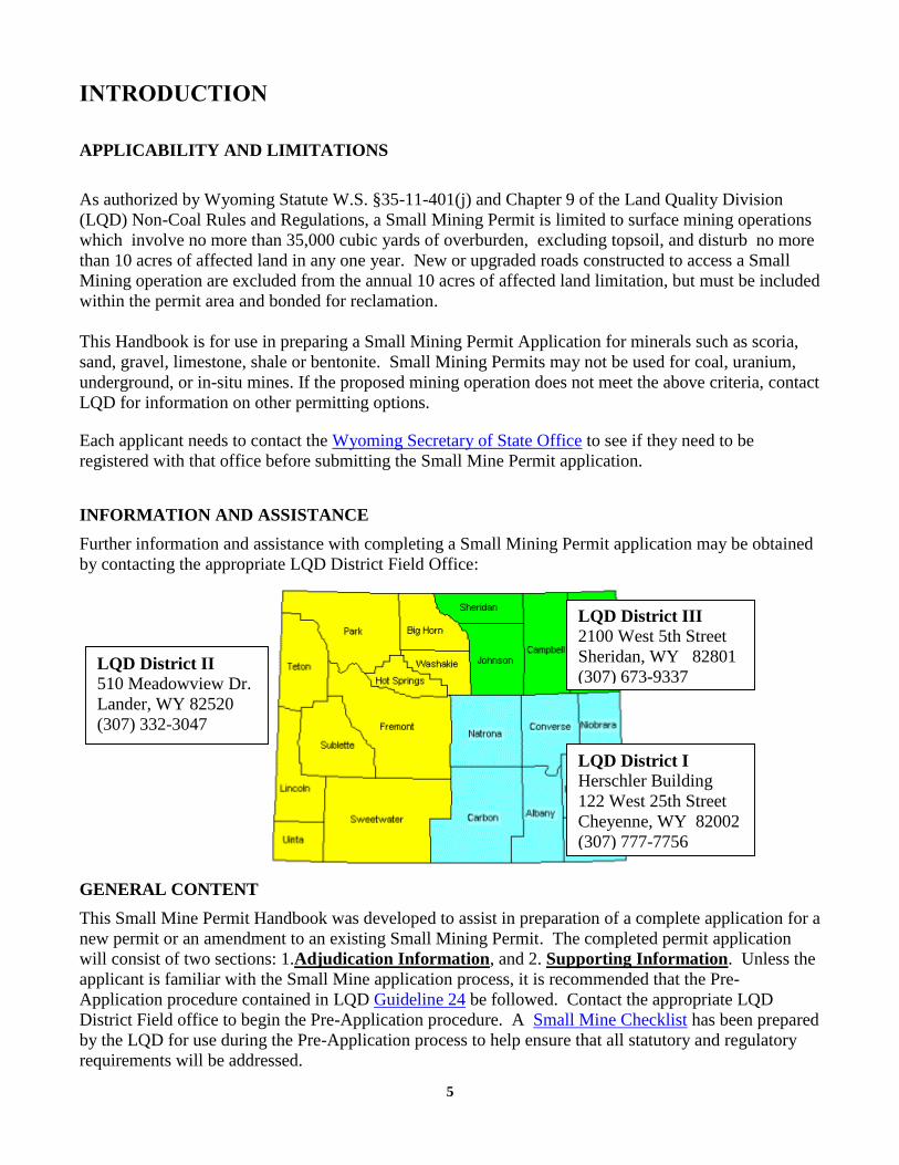
INFORMATION AND ASSISTANCE
Further information and assistance with completing a Small Mining Permit application may be obtained
by contacting the appropriate LQD District Field Office:
GENERAL CONTENT
This Small Mine Permit Handbook was developed to assist in preparation of a complete application for a
new permit or an amendment to an existing Small Mining Permit. The completed permit application
will consist of two sections: 1.Adjudication Information, and 2. Supporting Information. Unless the
applicant is familiar with the Small Mine application process, it is recommended that the Pre-
Application procedure contained in LQD Guideline 24 be followed. Contact the appropriate LQD
District Field office to begin the Pre-Application procedure. A Small Mine Checklist has been prepared
by the LQD for use during the Pre-Application process to help ensure that all statutory and regulatory
requirements will be addressed.
LQD District II 510 Meadowview Dr.
Lander, WY 82520
(307) 332-3047
LQD District III
2100 West 5th Street
Sheridan, WY 82801
(307) 673-9337
(307) 673-9337
LQD District I Herschler Building
122 West 25th Street
Cheyenne, WY 82002
(307) 777-7756

6
Part 1 of this Handbook:
Contains information on types of bonding, fees, permit review process and approval timetable.
Contains guidelines and a checklist for all of the major components needed for each section of
the application including links to Forms required in the application. The Applicant and the LQD
Staff should use the same checklists in preparing and reviewing the application.
Contains Contact References for agencies involved in the permitting process.
Contains an Endnotes section with all pertinent definitions and citations to the Wyoming
Environmental Quality Act and Chapter 9 of the LQD Non-Coal Rules and Regulations.
Part 2 of the Handbook:
Contains an Example Application. The Applicant should use the Example Application only for
guidance on content, completeness, clarity of presentation, etc. The application must contain
materials which directly refer to the specific conditions which occur within the permit area.
CURRENT FORMS
Links to all forms required in the small mine permit application are located in the sections of this
handbook that pertain to the given form. Completed examples of these Forms are found in the example
application section in the handbook.
Additional copies of the Small Mining Handbook and the application forms are available from any LQD
office or on the LQD website: About LQD.
Non-Coal LQD bonding forms, Guidelines, the 1973 Wyoming Environmental Quality Act, and the
Non-Coal Rules and Regulations are also available on request or from the above website.
NUMBER OF APPLICATION COPIES AND PAGINATION
The Applicant should submit the application and all supporting information directly to the proper LQD
District Office. The application should be submitted in a 3 ring binder with tabbed dividers labeled for
different sections of the application. Each page in the application should be uniquely numbered (see the
example application section of this handbook). If new materials are submitted in response to LQD
review comments, changed text or maps must be accompanied by an Index Sheet which lists each page
or map to be removed and replaced.
Each revised page or map must also be numbered to follow the existing pagination system in the
document.
The sections to be included in the permit application are shown in the Table of Contents section
beginning on page 8 of this Handbook.

7
District I (Cheyenne) needs only one complete copy, with original signed application
Forms.
District II (Lander) and District III (Sheridan) need two complete copies of the application.
One copy must contain original signed Forms which will be forwarded to Cheyenne. If
revisions are made during the review process in these Districts, two copies of revised text or
maps must also be submitted.
The Applicant will need to prepare at least one additional copy of the Application once the
DEQ review process has been completed and the application is ready for Final Public
Notice. When notified by the LQD, the Applicant will file the copy with the County Clerk
for viewing during the public notice period. This copy will be removed from the Clerk’s
Office after permit approval.
GENERAL APPLICATION FILING FEES, REVIEW PROCESS, AND TIMETABLE
1. When the Small Mining Permit application is submitted to the appropriate LQD District Office,
Form 1(s), Application for Small Mine Permit, must be accompanied by a filing fee of $100 plus
$10 per acre of land within the proposed permit area, up to a maximum of $2000. All filing fee
checks must be made payable to the Wyoming Dept. of Environmental Quality, Land Quality
Division. A link to Form 1(s) is provided on page 9.
2. Form 3, Application for License to Mine, must be accompanied by a $25 filing fee. A link to Form
3 is provided on page 9. A single check may be submitted for the combined fees associated with
Form 1(s) and Form 3.
3. Each Application will be reviewed for Completeness and then for Technical Adequacy.
a. Completeness Review By Statute, the LQD is required to notify the applicant in writing within
60 days of receipt of the application whether or not it is Complete and advise if any additional
information is required. Once the application is deemed Complete, the LQD will provide the
applicant with a Letter of Completeness which will provide instructions and a sample First Public
Notice for publication in a local newspaper.
b. Technical Review By Statute, the LQD is required to review the application for Technical
Adequacy within 150 days of determining that the application is Complete and then advise whether
or not it is suitable for Final Public Notice or if additional information is needed. When the
application is deemed Technically Adequate, the LQD will inform the applicant in writing that the
application is ready for Final Public Notice and provide instructions. The Final Public Notice is to be
published once per week for four weeks in the local newspaper and is also sent to landowners within
and adjacent to the permit area. At the same time, a copy of the application will be temporarily
placed at the local Office of County Clerk for public review and a Mine Plan map will be mailed to
the Wyoming Oil and Gas Conservation Commission.
4. Any interested person has the right to file objections to the application within 30 days after the last
publication date during the Final Public Notice period. If objections are filed, a public hearing
before the Wyoming Environmental Quality Council will be held within 20 days after the final date
for filing objections unless a different period is stipulated to by all parties. If no objections are filed,

8
the DEQ director will render a decision on the application within 30 days after the completion of the
public notice period.
SMALL MINE PERMIT APPLICATION CONTENTS
TABLE OF CONTENTS
The Small Mine Permit Application is divided into two parts. The parts are entitled Adjudication
Information and Support Information. Adjudication Information includes all of the forms, records and
legal documentation. Support Information includes baseline environmental information, the mine plan
and the reclamation plan. The following is a Table of Contents showing the sections in a typical Small
Mine Permit application.
ADJUDICATION INFORMATION
APPLICATION FOR SMALL MINE PERMIT FORM 1(S)
LICENSE TO MINE APPLICATION, FORM 3
SURFACE OWNER CONSENT, FORM 8
OTHER OWNER CONSENT STATEMENTS
PERMITS FROM OTHER AGENCIES
APPENDIX A-SURFACE AND MINERAL OWNERS WITHIN PERMIT AREA
APPENDIX B-SURFACE OWNERS WITHIN ½ MILE OF PERMIT AREA
APPENDIX C-LEGAL TABLULATION OF LANDS WITHIN PERMIT AREA
FIRST PUBLIC (COMPLETENESS) NOTICE
FINAL PUBLIC NOTICE
SUPPORTING INFORMATION
APPENDIX D-1 PREMINING LAND USE
APPENDIX D-3 ARCHAEOLOGICAL, PALEONTOLOGICAL AND CULTURAL RESOURCE SURVEYS AND
CLEARANCES
APPENDIX D-5 PREMINING TOPOGRAPHY AND OVERBURDEN
APPENDIX D-6 PREMINING SURFACE AND GROUNDWATER
APPENDIX D-7 PREMINING TOPSOIL, SUBSOIL AND OVERBURDEN INFORMATION
APPENDIX D-8 PREMINING VEGETATION INFORMATION
APPENDIX D-9 WILDLIFE INFORMATION
APPENDIX D-10 WETLANDS INFORMATION
MINE PLAN
RECLAMATION PLAN

9
RECLAMATION PERFORMANCE BOND-BOND CALCULATIONS
Guidelines to assist in the completion of the sections listed in the Table of Contents are described in the
following pages of this handbook, including hyperlinks to DEQ and other agency websites where forms
or additional information may be obtained.
ADJUDICATION MATERIALS
APPLICATION FOR SMALL MINE PERMIT: FORM 1s
1. The application filing fee is $100.00 plus $10.00 per acre up to a maximum of $2,000.00. Checks
are made payable to the Wyoming Department of Environmental Quality, Land Quality Division
2. Affix Corporate Seal on Page 3 when applicable. Wyoming does not require corporations to have a
seal. If a seal is not used, please write 'No Seal'.
3. Notary Seal on Page 3.
4. The bottom of each page of Form 1s must be initialed and dated by the applicant.
APPLICATION FOR LICENSE TO MINE: FORM 3
1. Filing fee of $25.00 made payable to the Wyoming Department of Environmental Quality, Land
Quality Division
2. Corporate Seal on Page 2 when applicable. If a seal is not used, please write ‘No Seal’.
3. Notary Seal on Page 2.
4. The bottom of each page of Form 3 must be initialed and dated by the applicant.
SURFACE LANDOWNER CONSENTi: FORM 8
NOTE: The surface landowner(s), if different from the owner(s) of the mineral estate, must sign
Form 8 to indicate their approval of the mine and reclamation plan, provide consent for the
mining operation on their lands, and grant unrestricted access to the operation by LQD
representatives to conduct inspections during normal business hours.
1. Each surface owner’s name must have an original signature and date.
2. Legal description on Form 8 must agree with that listed in Appendix C.
3. Must be signed and dated by a witness.
OTHER OWNER CONSENT STATEMENTSii
Written consent is needed if lands within 300 feet of an existing occupied dwelling, home, public
building, school, church, community or institutional building, park or cemetery will be affected. Each
written consent statement from the appropriate landowner or public agency must include the following
information:

10
1. The owner's full name, address, and phone number.
2. A statement by the owner identifying the proposed operator and the general location of the proposed
mining operation.
3. A statement confirming that the owner has reviewed the Mine and Reclamation Plans.
4. A statement that the owner has no objection to the proposed mining operation.
5. The owner's original signature and, if applicable, the owner’s title.
PERMITS FROM OTHER AGENCIES
Certain equipment or operations associated with a Small Mining operation may require permits from the
agencies listed below. The LQD permit application does not need to include copies of permits from
other agencies unless specifically requested by DEQ in the review process. Contact information for
other agencies is also provided at the end of Part I of this handbook.
1. DEQ Air Quality Division (AQD). Forms and instructions for AQD permits are available at: New
Source Construction Permits. These may include:
a. Mining/Quarry Operations – Non Coal
b. Separate permits for portable crushing, screening, hot mix asphalt plants or concrete batch
plants.
c. A Portable Facility Relocate/Operate Permit will be required if previously permitted
equipment will be moved to the mine site.
2. Permit from the DEQ Water Quality Division (WQD) for storm water discharge. Permit application
information is found at: WYPDES Storm Water Program.
3. Permit from the Wyoming State Engineer's Office (SEO) to appropriate surface water (Surface
Water Division) or groundwater (Ground Water Division) which is used in the mining or
material processing operation.
4. A Stock Reservoir Permit from the SEO will be required if a permanent post-mining impoundment
will be constructed. Forms are available at: SEO Applications & Forms
5. Permit from the U.S. Army Corps of Engineers to disturb or operate within wetlands or waters of the
United States. This authorization should be presented in Appendix D-10 of the application. The U.S.
Fish and Wildlife Service provides wetland mapping of some areas at: USFWS Wetlands Mapper
6. Wyoming Department of Transportation (WYDOT) Form M-3 Access Permit if the mining
operation will include a haul or access road that enters a controlled access (usually any State or
Federal) highway. Contact the nearest WYDOT District Office: WYDOT Districts
7. County Road Access Permit or written permission to access County Road.
8. The application should include a written statement from the appropriate City and/or County agency
that the proposed mining operation complies with local zoning provisions. This may require a
Conditional Use Permit.

11
9. Registration with the Wyoming Secretary of State. Required for all corporations, limited
partnerships, limited liability partnerships, and limited liability companies: Sec of State
10. Approval from the U.S. Bureau of Land Management (BLM) if surface or mineral rights are
Federally-owned. Contact the nearest BLM Field Office at: BLM Field Offices
11. Approval from the Wyoming Office of Lands and Investments (OSLI) if the State owns surface or
mineral rights: OSLI
12. Approval from the U.S. Bureau of Reclamation (BOR) if BOR holds surface or mineral rights.
Contact the BOR at the appropriate office: Reclamation Offices
13. Approval from the U.S. Forest Service (USFS) if the operation will be located on National Forest
lands: USFS
APPENDIX Aiii: SURFACE AND MINERAL OWNERS WITHIN PERMIT AREA
1. List of names and last known mailing address of owners of record of surface rights within the permit
area (these owners will be mailed a copy of the Final Public Notice).
The LQD interprets this requirement to include owners of record which would normally be recorded
in county courthouse records. Many counties have electronic records which may be accessed by the
internet. These owners of record of surface rights could include:
Federal agency surface ownership
Fee surface ownership as conveyed by will, quitclaim deed, warranty deed, special warranty
deed, etc.
Ownership of equity
Ownership of mortgage(s)
Ownership of property lien(s)
Certificate of appropriated (adjudicated) water rights
Surface grazing lease(s)
Surface use lease(s)
Rights-of-Way and easements
2. List of names and last known address of all mineral owners within permit area.
Note: If there is more than one surface or mineral owner, a map will be required to show
individual ownership units within the permit area.
APPENDIX Biv : SURFACE OWNERS WITHIN ½ MILE OF PERMIT AREA
1. List of names and last known mailing address of the owners of surface rights of lands (see examples
in Appendix A) within one-half mile of the permit area boundary. These owners will be mailed a
copy of the final public notice.
Note: If there is more than one surface owner, a map will be required showing ownerships
adjacent to the permit area. It may be possible to prepare a single map to show both Appendix A
and B ownerships if the ownership pattern is not complex. Each parcel on the map must be

12
uniquely numbered and referenced to a corresponding ownership listing in Appendix A and
Appendix B. If courthouse records show that certain parcels have multiple owners, each owner
must be listed separately, ie. it is not permissible to use “et al.” to indicate multiple owners.
APPENDIX Cv: LEGAL TABULATION OF LANDS WITHIN PERMIT AREA
1. Tabulate the lands within the permit area by legal description or bearing distance description and list
the acres within each parcel using LQD Form C1 (legal subdivision description) and/or Form C2
(metes and bounds description).
2. Tabulate by legal description the lands within the permit area for which no right to mine is claimed.
3. Include an original USGS topographic map or equivalent map showing:
The permit area boundary, including haul and access roads, and the surrounding area at least
one-half mile in all directions.
The boundaries of lands which will be affected.
Surface waters, including lakes, ponds, streams, springs, canals, drainages, irrigation ditches and
water courses within and adjacent to the permit area.
The location of water wells inside and within one-half mile of the permit area if the maximum
expected depth of the mine pit is within 20 feet of or below the water tablevi. Specific well data
is presented in Appendix D-6.
Buildings, structures, and dwellings.
Roads, railroads, public or private rights of way or easements, utility lines, oil and gas wells.
The outline of all areas previously disturbed by or which will be affected by underground
mining.
Include the mining claim name and mining district if appropriate.
Note: Haul and access roads must be included in the permit area to a junction with the nearest
Public Road which is defined in Chapter 1, Section 2.(as) as "... any thoroughfare open to the
public which has been and is being used by the public for passage of vehicles, and is maintained by
public funds".
FIRST PUBLIC (COMPLETENESS) NOTICEvii
Within 60 days of submittal, the applicant will be notified by LQD that the application is Complete and
suitable for the First Public Notice or if additional information is needed. The instructions and format
for the public notice are found here: Format 1 - 1st Publication.
The First Public Notice is published once a week for two consecutive weeks in a newspaper of general
circulation in the locality of the mining site. The newspaper publisher’s Affidavit of Publication and a
copy of the published notice is then returned to the LQD District Office.
FINAL PUBLIC NOTICEviii
Immediately following the Completeness review, LQD will conduct a more detailed Technical Review.
Within 150 days, the applicant will be notified that the application is suitable for Final Public Notice and
mailings to all owners listed in Appendix A and Appendix B. LQD will provide instructions, a sample

13
public notice and an Affidavit of Notice that needs to be signed and returned by the applicant. See Non-
Coal Public Notice Format No. 2.
1. The Final Public Notice must be published in a newspaper of general circulation in the locality of the
mining operation once a week for four consecutive weeks.
2. A copy of the application must be filed at the County Clerk’s office no later than the first day of the
publication period.ix An original Affidavit of Filing from the County Clerk’s Office is sent to LQD.
This copy must remain available for public inspection throughout the public notice period. Once the
application is approved, it must be retrieved from the Clerk’s office.
Note: If the application contains any confidential archeological, paleontological or cultural
resources information in Appendix D-3, this Appendix must kept in a separate confidential binder
and not placed on file with the County Clerk.
3. Mail, within 5 days after the first publication, a copy of the notice to all parties listed in Appendices
A and B.
4. Mail, within 5 days after the first publication, the application Mine Plan map to the Wyoming Oil
and Gas Commission (address listed in Contact References on page 26).
5. At the completion of the four week period of final publication, an original Affidavit of Publication
from the local newspaper is sent to LQD.
6. As soon as possible, and before the end of the public comment period, the signed original Affidavit
of Notice is sent to LQD.
SUPPORTING INFORMATION
APPENDIX D-1: PRE-MINING LAND USEx
Provide a general description of present land uses within the permit boundary. Include any prior or
existing mining permits.
APPENDIX D-3: ARCHAEOLOGICAL, PALEONTOLOGICAL AND CULTURAL
RESOURCE SURVEYS AND CLEARANCESxi
1. If the Surface and Mineral Ownership is Private:
No archaeological, paleontological or cultural surveys are required on private lands for a Small
Mining Permit applicationxii. A statement to this effect should be included as
Appendix D3.
2. If either the Surface or Mineral Ownership is Federal:
Federal agencies will require a survey for cultural and paleontological resources. The Applicant
should contact the agency to determine specific requirements. The applicant will be responsible for
obtaining clearances and written concurrence from the Wyoming State Historic Preservation Office:
SHPO Website.

14
In this case, an Appendix D-3 is submitted in a separate binder marked “Confidential” and should
include:
a. All applicable “existing information” statements from SHPO
b. Surveys
c. Clearances from the Federal Agency and written concurrence from SHPO
If the Clearance statement from either SHPO or the federal Agency requires mitigation of specific
cultural sites, the Applicant must state in Appendix D-3 and the Mine Plan whether the site will be
investigated prior to disturbance or avoided. If the applicant chooses to avoid the site, this
commitment must be stated in Appendix D3 and the Mine Plan. In no case should the text and maps
in the Mine Plan precisely locate any sensitive sites.
APPENDIX D-5: PREMINING TOPOGRAPHY AND OVERBURDENxiii
1. Description and depth of the overburden material between the topsoil/subsoil and the mineral seam
2. Pre-mining topography
Map (generally a USGS topographic map or equivalent) showing the pre-mining contours of the
permit area and surrounding lands. Reference to another map in the application will be adequate if it
shows the existing contours at a scale that allows for the review of topography.
APPENDIX D-6: PREMINING SURFACE AND GROUNDWATERxiv
1. Surface Water Description
a. Names and description of surface water features (streams, stock ponds, reservoirs or lakes,
irrigation ditches, etc.) within the permit area. The topographic map required in Appendix D-5
above may be referenced.
b. A list of the water rights associated with any stream, irrigation ditch, stock pond, reservoir or
lake within the permit area.
c. An estimate of the average flow rate of any stream or irrigation ditch within the permit area.
d. Tabulation of the storage volume of any stock pond, reservoir or lake within the permit area.
2. Groundwater Description
a. Estimate the depth to groundwater. Include a description of how the groundwater depth was
determined, such as measurement of adjacent wells.
b. Map the location of groundwater wells inside and within one-half mile of the permit area if the
maximum expected depth of disturbance will extend within twenty feet of the water table. If the
wells were located on the USGS topographic map provided in Appendix C, a cross-reference is
acceptable.
c. Include documentation of contact with the Wyoming State Engineer’s Office (SEO) to obtain a
complete listing of groundwater wells with associated data related to the well.

15
Note: The SEO maintains an on-line water rights database on their website at: SEO. Printed results
of an on-line query of the database may be used to satisfy this requirement. Well locations may be
determined using a search by township, range, section and quarter-quarter. Search results should be
presented as a spreadsheet and organized to show all wells within the one-half mile radius. The
following is an example SEO water right query downloaded from the website and the resulting
Water Rights Map:

16

17
APPENDIX D-7: PREMINING TOPSOIL, SUBSOIL & OVERBURDEN INFORMATIONxv

18
1. Prepare a Soils Map showing the soil types, sampling locations, and proposed salvage depths for
each type in the permit area.
2. Include a report describing each soil type which will be affected by mining and describe their
suitability for reclamation.
Note: If the area has been mapped, soils information will be available from a local office of the Natural
Resources Conservation Service (NRCS): USDA Service Center Locater.
As an alternative, on-line data is available from the NRCS Web Soil Survey. The Web Soil Survey
requires the applicant to first define an Area of Interest (AOI). This can be accomplished using the Area
of Interest Interactive Map and defining a local AOI with rectangle or polygon tools. Another option to
define an AOI is by uploading an ESRI shapefile of the proposed permit area.
This Topsoil Salvage Volume Table was developed from an area where soils have been mapped:
19
3. Tabulate the volume of topsoil and subsoil which will be salvaged from affected lands. This may be
accomplished by the following method:
Excavate test pits on an approximate 300 foot grid over each soil type within the affected area
boundary. Photograph each pit and record the depth of topsoil and subsoil. Insert photos of each pit
in Appendix D-7 (see Example Application). The pit locations must be shown on the Soils Map.
Unless there are mitigating circumstances, all topsoil and subsoil must be salvaged and stockpiled
from all lands to be affected by mining, including pit areas, roads, and mine facilities. Topsoil and
subsoil will be stored in separate stockpiles and labeled with signs.
4. Describe the nature, depth, and volume of overburden material that will be salvaged. Overburden
material, removed from between the topsoil/subsoil and the mineral seam, will be stockpiled
separately.
APPENDIX D-8 PREMINING VEGETATION INFORMATIONxvi
1. Prepare a Vegetation Map, showing vegetation types, range sites, or ecological response units for
lands included in the permit area. The map must clearly identify the permit and the affected area
boundaries.
2. Labeled photographs shall be submitted in this section to demonstrate each vegetation type. It is
important to document areas of sparse vegetation and any areas containing noxious weeds.
Locations photographed shall be shown on the above Vegetation Map.
3. Include a range condition survey or equivalent for the permit area. The survey may be available
from the NRCS for lands within the permit area. The applicant should present the most site-specific,
quantitative and qualitative data available. A directory of NRCS offices is available here: NRCS
Service Center Locater
If site-specific NRCS information is not available, the applicant may collect pre-mining range
condition data using the following Pre-Mine Vegetation Condition format. Before conducting the
field inspection, obtain a current list of the noxious weeds listed for the county in which the site is
located. Local Weed and Pest office information is available at the Wyoming Weed & Pest
Council.

20
NOTE: COMPLETE ONE FORM FOR EACH VEGETATION TYPE.
PRE-MINE VEGETATION CONDITION FORM (Adapted from Non-Coal Standard Operating Procedure 7.1 – Attachment C, Revegetation Analysis)
Vegetation Type _______________
Observer _________________ Veg. Survey Date ________ RATING
VALUE
PERENNIAL
GRASS AND
GRASS-LIKE
SPECIES
FULL AND
SUBSHRUBS
PERENNIAL
FORBS
NOXIOUS
WEEDS*
ANNUAL
FORBS AND
ANNUAL
GRASSES
TOTAL PLANT
COMMUNITY
0
Little or no perennial grass cover
No shrubs observed
No perennial forbs observed
Heavy weed cover
Occasional to frequent encounter of a variety of species
Uniform community structure
1
Slight cover of relatively few individual species
Infrequent encounter of isolated individuals
Few perennial forbs observed
Moderate weed cover
Few observed; infrequent encounter of isolated individuals
Some variability in community structure with some regeneration being observed
2
Moderate cover with a few individual species dominating
Occasional observation of relatively few species
Perennial forbs often observed
Low weed cover
Few or none observed
High degree of structure variability with regeneration being frequently observed
3
Good cover with relatively few species dominating
Several species being readily observed
PRE-MINE CONDITION RATING
Sum of Values Rating 0 – 5 Poor 4 - 5 Fair 6 - 10 Good 9 - 16 Excellent
4
Good cover with 4 or more species being co-dominates
Good density with 4 or more species frequently encountered
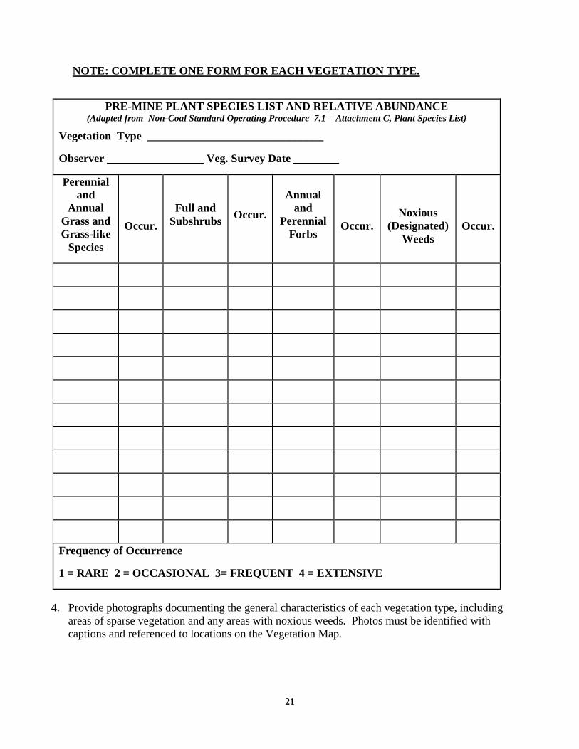
3. Provide a list of species occurring in the permit area and a ranking of their relative abundance for
each vegetation type shown on the Vegetation Map using the following format:
21
NOTE: COMPLETE ONE FORM FOR EACH VEGETATION TYPE.
PRE-MINE PLANT SPECIES LIST AND RELATIVE ABUNDANCE (Adapted from Non-Coal Standard Operating Procedure 7.1 – Attachment C, Plant Species List)
Vegetation Type _______________________________
Observer _________________ Veg. Survey Date ________
Perennial
and
Annual
Grass and
Grass-like
Species
Occur.
Full and
Subshrubs Occur.
Annual
and
Perennial
Forbs
Occur.
Noxious
(Designated)
Weeds
Occur.
Frequency of Occurrence
1 = RARE 2 = OCCASIONAL 3= FREQUENT 4 = EXTENSIVE
4. Provide photographs documenting the general characteristics of each vegetation type, including
areas of sparse vegetation and any areas with noxious weeds. Photos must be identified with
captions and referenced to locations on the Vegetation Map.

22
APPENDIX D-9 WILDLIFE INFORMATIONxvii
1. The Applicant must initially write the Wildlife Habitat Protection Program at the Wyoming Game
and Fish Department (WGFD) to request site-specific wildlife information and recommendations.
A sample letter is provided in Appendix D-9 of the Example Application.
2. An initial consultation letter is not required for the U.S. Fish and Wildlife Service (USFWS).
Instead, the applicant or consultant should first review general recommendations for protecting
threatened and endangered species at the Wyoming Field Office. If the website does not provide
sufficient information, or if there are additional questions, the applicant or consultant should then
write or call the Field Office. After baseline studies incorporating this information are conducted,
reports and maps are then provided to the Field Office for review. The USFWS will then be able to
provide specific recommendations on measures to protect species or habitats of concern.
3. Examples of information to be provided in Appendix D-9 may include:
What Important Habitats are known to exist within and adjacent (one-half mile) to the permit
area?
Important Habitat means areas of especially high value for a diversity of wildlife species or areas
that provide certain elements essential to the existence of certain groups of wildlife. Examples of
important habitat include, but are not limited to, wetlands, riparian areas, rim rocks, areas
offering special shelter or protection, reproduction and nursery areas, and wintering areas.xix
Are there perennial streams supporting fish populations in the area to be disturbed by mining?
The existence of white-tailed prairie dog towns within or adjacent to the permit area. If a town
does exist, the Applicant must contact the USFWS to determine whether a survey for black-
footed ferrets is warranted.
Note: Ferret searches are not required in Black-tailed prairie dog towns statewide.
Information on Greater Sage Grouse. In 2012, Wyoming DEQ and Wyoming Game and Fish
Dept. entered into a Memorandum of Understanding (DEQ/WGFD MOU) regarding the
implementation of the Governor’s Executive Order - GREATER SAGE-GROUSE CORE AREA
PROTECTION. Information on Sage Grouse, including links to the Executive Order and Core
Area Maps, may be found on the WGFD Sage Grouse Managment Website.
At least 45-60 days prior to submitting a Small Mining Permit, the applicant should contact LQD
for a determination on whether or not the proposed permit will be within Sage Grouse core area.
If it is, LQD will notify the applicant and request that WGFD consultation be initiated.
Wyoming Game and Fish Department (WGFD) Habitat Protection Services must then be
contacted at 307- 777-4506. The project proponent will be required to conduct a
Density/Disturbance Calculation Tool (DDCT) analysis for inclusion in Appendix D-9. If the
proposed project lies outside core area but is within 2 miles of an occupied lek, Item 7 of the
Executive Order requires that a one-quarter (1/4) mile no surface occupancy standard and a two

23
(2) mile seasonal buffer should he applied. Seasonal restrictions will be from March 15 to June
30 annually.
APPENDIX D-10 WETLANDS INFORMATION
1. Include a National Wetland Inventory (NWI) map. National Wetland Inventory mapping is
available from the USFWS using the Wetlands Mapper. The permit area and affected area
boundaries must be added to the NWI map.
2. If wetlands exist that will be disturbed or impacted by mining, the applicant shall perform a wetland
delineation using U.S. Army Corp of Engineers (USACE) procedures. A copy of the approved
Wetlands Mitigation Plan created under the direction of the Corps of Engineers is to be included in
Appendix D-10.
3. The USACE will require a permit to place fill in or otherwise affect wetlands or waters of the U.S.
Waters of the U.S .are defined as:
Coastal and inland waters, lakes, rivers and streams that are navigable waters of the United
States, including their adjacent wetlands.
Tributaries to navigable waters of the United States, including adjacent wetlands;
Interstate waters and their tributaries, including adjacent wetlands; and
All other waters of the United States not defined above, such as isolated wetlands or lakes,
intermittent streams, prairie potholes and other waters that are not part of a tributary system to
interstate waters of the United States, the degradation of destruction of which could affect
interstate commerce.
4. If wetlands are present in the permit area, but will not be directly affected, either through direct
disturbance or by affecting the contributing watershed, this should be clearly stated in the Mine Plan.
MINE OPERATIONS PLANxx
1. Provide a general description of the nature and scope of the proposed mining operation, including:
a. Roads to be constructed
b. Mining methods
c. General equipment list
d. Projected scheduled for the life of mine
e. Nature of the ore reserve and estimated pit depth
2. Include a Mine Plan Map (or Maps), labeled with a revision date, scale, north arrow, and title block,
showing the location of all activities associated with the operation, including:
a. The Permit boundary
b. The Disturbance Area boundary. If converting the operation from a Limited Mining Operation,
show the original permit area (see Example Application).
c. All roads associated with the operation
d. All temporary drainage control, diversion structures
e. Topsoil and subsoil stockpiles
f. Spoil stockpiles.
g. Ore/mineral stockpiles.

24
h. Reject material stockpiles.
i. The processing site and other processing facilities such as wash ponds, etc.
j. The pit progression for at least the first two years of operation, labeled with the year of
disturbance. Alternatively, the pit progression areas can be numbered and cross-referenced to a
table in the Mine Plan which provides details on pit progression by year. The use of a separate
table will allow future revisions to the mine schedule to be made without replacing the Mine Plan
Map.
Note: Paper size of 11” x 17” or larger may best allow a scale which demonstrates the above
requirements and provides the details necessary for the review by DEQ.
3. General description of the mine facilities and construction methods in relation to the mine plan
and/or facilities map, including:
a. Buildings, processing plants, and other facilities, including a discussion of fuel storage on
site.
b. Access and haul roads.
c. Utility Rights of Way (ROW).
d. Sedimentation and treatment ponds.
e. Railroads, conveyors, or other material load-out facilities.
f. Mineral stockpile sites.
g. Access control features such as fences, berms, etc.
h. A description of drainage/surface water control structures.
4. General description of the mining methods and schedule, including:
a. Pit excavation and backfill. Include typical cross-sections oriented perpendicular to each other
and illustrating the natural ground surface elevation, top and bottom of the mineral seam, the
maximum expected depth of mining, and the approximate elevation of the groundwater table.
Cross-sections must show surface elevations for a distance beyond the outlines of the affected
area.
b. Description of topsoil and subsoil salvage and stockpiling procedures, including stripping
methods, stockpile berms, stockpile identifications signs, and temporary seeding for stabilization.
This section must include an estimate of the depth and volume of topsoil to be salvaged on an
annual basis.
c. A description of spoil stockpiling.
d. A description of processed and non-saleable mineral stockpiles.
5. A detailed description of the expected pit progression for at least the first two years of the operation
and a general estimate for the life of mine. This section should also contain a commitment to revise
the permit document if the pit progression schedule changes. Use of a table in the Mine Plan which
is cross-referenced to the Mine Plan Map is suggested as a way to easily revise future schedule
changes.
6. A plan for storage or disposal of waste materials that may be generated by the mining operation.
a. In most cases, the plan will simply state that all wastes will be disposed off-site at an
approved solid-waste disposal site, such as a municipal landfill or transfer station.
b. Importation and disposal of “clean fill” within the permit area may be permissible only if a plan
is provided and written permission from the landowner and LQD is obtained. Clean fill means

25
material consisting solely of uncontaminated natural soil and rock, hardened asphalt rubble,
bricks and concrete rubble with no protruding rebarxxi. Typical language is provided in the Mine
Plan of the Example Application.
c. Plan for disposing of petroleum contaminated soils.
d. Plan for disposing of human waste.
7. A plan for promptly treating or disposing of all acid-forming or toxic materials or materials
constituting a fire, health or safety hazard uncovered during or created by the mining process. The
plan must prevent pollution of surface or subsurface water and prevent threats to human or animal
health and safety.
8. Procedures to avoid constituting a public nuisance. LQD Standard Operation Procedure No. 1.12 –
Addressing Public Nuisance Issues will provide additional information for preparing this section. At
a minimum, these procedures will include the following:
a. A statement of whether or not occupied dwellings, structures, parks, or cemeteries occur within
300 feet of the mining operation. If so, letters of consent from affected owners or agencies are
required.
b. A statement on normal hours and days of operation.
c. A commitment to treat all unpaved portions of the mine with water and/or chemical dust
suppressants on a schedule sufficient to control fugitive dust. Include a statement of the source,
quality and quantity of water that will be used for dust control and processing in the mining
operation.
d. A plan to control lighting issues if lights are to be used at night.
e. A commitment to conspicuously post and maintain at the entrance to the mining operation a
permit identification signxxii which contains the following information:
The name, address and telephone number of the operator.
The name of the operator's authorized agent, if any.
The Land Quality Division permit number for the operation.
f. Include a blasting plan if explosives will be used. The plan must state that only Certified
Blasters will conduct operations and demonstrate that blasting practices will not endanger public
safety. The LQD Blasting Program Principal should be contacted for assistance in developing an
acceptable blasting plan.
g. A plan for fencing to prevent unauthorized access of persons, livestock or wildlife and to protect
the surface owner’s or grazing lessees ongoing operations.
See LQD Guideline 10.
h. A commitment to a maximum speed limit on haul and access roads. The Wyoming Game &
Fish Dept. generally requests a 30 maximum speed limit on haul and access roads to minimize
truck/wildlife collisions.
i. Commitments to not push any materials over steep slopes or escarpments, to place safety berms
above highwalls, and to leave an adequate buffer between the final highwall and topsoil
stockpiles to easily facilitate topsoil replacement.
j. Plans for safely entering a controlled access highway or county road.
k. Plans to minimize impacts to Sage-grouse, threatened or endangered plant and animal species,
Migratory Birds of High Federal Interest, and other wildlife with important habitat as described
in Appendix D-9.
l. A commitment to prevent the spread of designated and prohibited noxious weeds on lands
disturbed by the mining operation. If the use of chemical herbicides is necessary, include a

26
commitment to consult with the local County Weed and Pest agency and to use licensed
herbicide applicators.
RECLAMATION PLANxxiii
1. Include a statement describing the proposed post-mining land uses and a plan whereby the operator
will reclaim all of the affected lands to achieve these uses.
2. Include a Reclamation Plan Map showing the proposed approximate post-mining contours and
illustrate reclamation progressions or cross-reference phases with dates as provided in Item 8 below.
Contours should extend one-half mile outside of the permit area with consistent intervals. The scale
of the post-mining contour map should be the same as the Mine Plan map. Alternatively, if the Mine
and Reclamation Plan maps are presented as engineering designs, the Applicant and the LQD should
reach mutual agreement on the map scale prior to application submittal.
Note: The Administrator may waive the requirement for a post-mining contour map if
requested by the applicant and the degree of surface disturbance is small.
3. Typical cross sections oriented perpendicular to each other shall be provided to show the original
natural ground surface, the maximum depth of mining, the maximum horizontal extent of mining,
and the proposed reclamation surfaces and slopes. Cross-sections should show surface elevations for
a reasonable distance beyond the affected area.
4. Describe the backfill and surface re-contouring methods, including how the post mining re-
contouring plan will tie to the original surfaces and drainages, the post-mining slope steepness
(generally 3:1 or less), and final drainages.
5. Description of the re-vegetation practices including:
a. Methods and schedule for topsoil redistribution, including the depth of subsoil and topsoil to be
evenly replaced.
b. Methods and schedule for seedbed preparation.
c. Methods and schedule for seeding.
d. The type and amount of seeds (plant species) for seeding.
e. A commitment to use certified weed-free seed.
f. Methods, composition of and schedule for any mulch application.
g. Description of methods to protect the re-vegetated areas from domestic animal grazing for two
years after reclamation and not before the release of the bond.
h. Description of noxious weed control during the reclamation period and until final bond
release.
6. Description of methods of reclamation for effective control of erosion, siltation and pollution of
affected stream channels and stream banks.
7. Detailed description and plans for any permanent post mining impoundments (stock ponds). If a
permanent impoundment is planned, the Reclamation Plan must contain or reference a Stock Water
Reservoir Permit from the State Engineer’s Office. Impoundment plans must demonstrate that the
structure is designed for permanent stability and that the slopes and contouring will prevent safety
hazards and allow for safe access for people, wildlife and livestock.
8. Projected timetable for completion of the Reclamation Plan. Revegetation success shall be evaluated

27
by the LQD using qualitative measures no sooner than the fifth growing season following
completion of reclamation.
Note: The following definitions may be useful in writing the Reclamation Plan.
W.S. §35-11-103(e)(iii) states that "Contouring" means grading or backfilling and grading the
land affected and reclaiming it to the proposed future use with adequate provisions for
drainage. Depressions to accumulate water are not allowed except if approved as part of the
Reclamation Plan.
Chapter 1, Section 2.(al) states that "Mulch" means plant residue or other suitable materials
placed upon the soil surface to aid in soil stabilization and soil moisture conservation.
W.S. §35-11-103(e)(i) states that "Reclamation" means the process of reclaiming an area of
land affected by mining to use for grazing, agricultural, recreational, wildlife purposes, or any
other purpose of equal or greater value. The process may require contouring, terracing,
grading, re-soiling, re-vegetation, compaction and stabilization, settling ponds, water
impoundments, diversion ditches, and other water treatment facilities in order to eliminate
water diminution (reduction) to the extent that existing water sources are adversely affected,
pollution, soil and wind erosion, or flooding resulting from mining or any other activity to
accomplish the reclamation of the land affected to a useful purpose.
Chapter 1, Section 2.(au) states that "Reclaimed land surface" means affected land which has
been backfilled, graded, contoured, and re-vegetated in accordance with an approved
reclamation plan.
Chapter 9, Section 6. Evaluation of Revegetation Success states that revegetation will be
evaluated utilizing qualitative methods no sooner than the fifth growing season. Revegetation
will be considered successful when: 1) the established vegetation species are self-renewing; 2)
the total vegetative cover of perennial species, excluding noxious weeds, and any species in the
approved seed mix is at least equal to the total vegetative cover of perennial species, excluding
noxious weeds, on the area before mining; and 3) the species diversity and composition are
suitable for the approved postmining land uses.
RECLAMATION PERFORMANCE BOND -BOND CALCULATIONSxxiv
The purpose of the reclamation performance bond is to assure that the operator will conduct the
mining operation in compliance with the Act and the LQD Rules and Regulations. In the case of
abandonment of the operation, the LQD will recommend forfeiture of the bond by the Wyoming
Environmental Quality Council and to use the proceeds to reclaim all disturbances. The bond is
not submitted until after the LQD concurs with the operator’s estimate of the cost to reclaim the
mine at the end of the first year of mining.
There are a number of bonding methods accepted by the Land Quality Division. These are
described in the Reclamation Performance Bonds General Instructions document posted on the
LQD website. Briefly, the methods include:
• Corporate Surety Bonds using Form 2OTH1 (PDF Format). If Federal lands are involved, use
the State/BLM Form 2SF1 (PDF Format).
28
• Federally insured Automatically Renewable Certificates of Deposit (C.D.) or Money Market
Accounts made payable solely to the Wyoming Department of Environmental Quality, Land
Quality Division. If Federal Lands are involved, the C.D. must be made payable to both the
Land Quality Division and the U.S. Dept. of the Interior–BLM. Requirements for C.D.’s are
found in the General Instructions.
• U.S. Treasury Bonds, Bills, or Notes
• Cash
• Letters of Credit, payable solely to the Department of Environmental Quality, Land Quality
Division. The Letter of Credit Format must be followed verbatim. If Federal Lands are
involved, the Letter of Credit must be made payable to both the Land Quality Division and the
U.S. Department of the Interior - BLM.
• Self-bonding
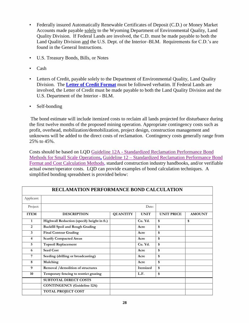
The bond estimate will include itemized costs to reclaim all lands projected for disturbance during
the first twelve months of the proposed mining operation. Appropriate contingency costs such as
profit, overhead, mobilization/demobilization, project design, construction management and
unknowns will be added to the direct costs of reclamation. Contingency costs generally range from
25% to 45%.
Costs should be based on LQD Guideline 12A - Standardized Reclamation Performance Bond
Methods for Small Scale Operations, Guideline 12 – Standardized Reclamation Performance Bond
Format and Cost Calculation Methods, standard construction industry handbooks, and/or verifiable
actual owner/operator costs. LQD can provide examples of bond calculation techniques. A
simplified bonding spreadsheet is provided below:
RECLAMATION PERFORMANCE BOND CALCULATION
Applicant:
Project: Date:
ITEM DESCRIPTION QUANTITY UNIT UNIT PRICE AMOUNT
1 Highwall Reduction (specify height in ft.) Cu. Yd. $ $
2 Backfill Spoil and Rough Grading Acre $
3 Final Contour Grading Acre $
4 Scarify Compacted Areas Acre $
5 Topsoil Replacement Cu. Yd. $
6 Seed Cost Acre $
7 Seeding (drilling or broadcasting) Acre $
8 Mulching Acre $
9 Removal /demolition of structures Itemized $
10 Temporary fencing to restrict grazing L.F. $
SUBTOTAL DIRECT COSTS
CONTINGENCY (Guideline 12A)
TOTAL PROJECT COST

29
Note 1: Chapter 3, Sections 2(i)(viii)(A) and (B) of the Non-Coal Rules and Regulations allow
for a certain roads to be left unreclaimed at the request of the surface landowner. The
landowner’s consent to leave specific roads unreclaimed must be documented in writing in the
Reclamation Plan. In this case, bond calculations should specifically exclude the road(s).
Note 2: Chapter 3, Section 2(j)(i) 2(j)(ii) of the Non-Coal Rules and Regulations allow for
certain buildings or facilities to be left unreclaimed if it can be demonstrated that they will be
of beneficial use in meeting the post-mining land use, or if the surface landowner provides
consent to leave them intact. The landowner’s consent must be documented in writing in the
Reclamation Plan. In this case, bond calculations should specifically exclude the removal of
the specified structures.

30
CONTACT REFERENCES
a. Wyoming Game & Fish Department (contact for Appendix D-9 wildlife information)
Wildlife Habitat Protection Program
5400 Bishop Blvd.
Cheyenne, WY 82006
1-800-842-1934 WGFD Wildlife and Habitat
b. Wyoming State Historical Preservation Office (SHPO) (Contact For Appendix D-3)
2301 Central Avenue
Barrett Building, Third Floor
Cheyenne, Wyoming 82002
Phone: 307-777-7697 Wyoming State Historic Preservation Office
c. U.S. Fish and Wildlife Service (contact for Appendix D-9 wildlife information)
4000 Airport Parkway
Cheyenne, WY 82001
(307) 772-2374 USFWS Mountain-Prairie Region
d. U.S. Army Corp of Engineers (contact for Appendix D-10 wetlands information)
Wyoming Regulatory Office
2232 Dell Range Blvd., Suite 210
Cheyenne, WY 82009-4942
(307) 772-2300 USACE Omaha District
e. Wyoming Oil and Gas Conservation Commission (to be sent copy of Mine Plan Map during public
notice)
P.O. Box 2640
Casper, WY 82602
(307) 234-7147 Oil & Gas Conservation Commission
f. Wyoming State Engineer’s Office
Herschler Bldg., 4 East Surface Water Division 307-777-6475
122 West 25th Street Groundwater Division 307 -777-6163
Cheyenne, WY 82002
Application forms and Water Rights Database: State Engineer's Office
g. Wyoming DEQ, Water Quality Division (contact for all water quality permits)
122 West 25th Street
Cheyenne, Wyoming 82001
(307)-777-7781 DEQ Water Quality Division
h. Wyoming DEQ, Air Quality Division (contact for all air quality permits)
Herschler building
122 w. 25th street
Cheyenne, WY 82002
(307)-777-7391 DEQ Air Quality Division

31
ENDNOTES
i Required by W.S. §35-11-406(b) (xi) and Non-Coal R&R Chapter 9, Sec. 2.(a)vi).
ii W.S. §35-11-406(m) allows for denial of a permit application unless these issues are addressed.
iii Required by W.S. §35-11-406(a)(iv), Item 3. (a) of Form 1(s), and Chapter 9, Sec. 2.(a)(iv).
iv Required by W.S. §35-11-406(a)(v), Item 3. (b) of Form 1(s), and Chapter 9, Sec. 2.(a)(v).
v Required by W.S. §35-11-406(a)(vi) and Chapter 9, Sec. 2.(a)(vii).
vi Chapter 9, Section 1. (a)(i)(d)(iii) requires this information if the pit or other excavations will project within
twenty (20) feet of or will extend below the existing water table.
vii Completeness Review procedures are prescribed by W.S. §35-11-406(e) through W.S. §35-11-406(g)n
viii Technical Review and Final Publication procedures are prescribed by W.S. §35-11-406(h) through W.S.
§35-11-406(k).
ix County Clerk filing required by W.S. §35-11-406(d)
x A description of pre-mining land use is required by Chapter 9, Section 3.(a)(i).
xi The requirement to address archaeological survey issues derives primarily from W.S. §35-11-406(a)(xv) and
W.S. §35-11-406(m)(iii)
xii 10/2/2012 Cultural Resources Policy and Notice of Final Adoption of Noncoal Rules – Department of
Environmental WQuality, Land Quality Division, Nancy Nuttbrock, Administrator
xiii Appendix D-5 pre-mining topography requirements derive from Chapter 9, Section 1. (a)(i)(C)(II).
xiv Appendix D-6 Surface and groundwater requirements derive from Chapter 9, Section 3.(a)(iii)
xv Appendix D-7 Baseline topsoil ,subsoil, and overburden descriptions derive from Chapter 9, Section 3.
(a)(iv and v).
xvi Appendix D-8 vegetation requirements derive from Chapter 9, Section 3. (a)(ii).
xvii Appendix D-9 wildlife information requirements derived from W.S. §35-11-406(a) (xv) and W.S. §35-11-
406(m)(iii) to prevent conflict with federal laws and disturbance of Crucial Critical , or Important Habitats.
Presentation of this information may prevent or alleviate future problems should an endangered or protected
species be impacted by mining.
xix Important Habitat defined in Non-Coal R&R, Chapter 1, Sec. 2(ae).
xx Mine Operations Plan required by W.S. §35-11-406(b) and Chapter 9, Sec. 4.
xxi Clean Fill is defined in Chapter 1 of the Solid Waste Rules and Regulations.\
xxii A permit identification sign is required by W.S. §35-11-415(b) (i).
xxiii Reclamation Plan required by W.S. §35-11-406(b) and Chapter 9, Section 5.
xxiv W.S. §35-11-406(b)(vi), §35-11-417(a) and (c)(i) detail the content and purpose of the bond.