
WY OM E AIR PARK AIRSPA E HANGE PROPOSAL FORMAL SU …
25
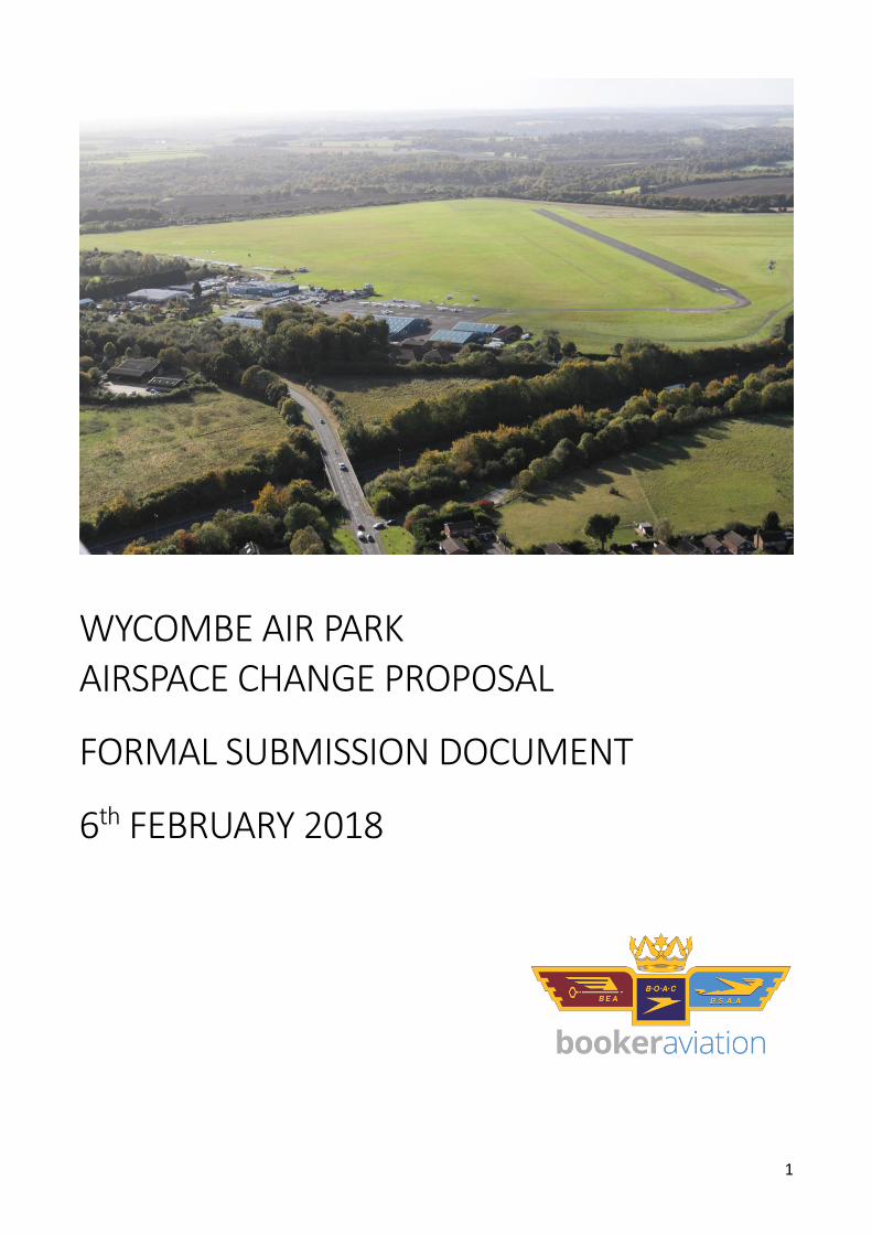
1 WYCOMBE AIR PARK AIRSPACE CHANGE PROPOSAL FORMAL SUBMISSION DOCUMENT 6 th FEBRUARY 2018
Transcript of WY OM E AIR PARK AIRSPA E HANGE PROPOSAL FORMAL SU …
1
WYCOMBE AIR PARK AIRSPACE CHANGE PROPOSAL
FORMAL SUBMISSION DOCUMENT
6th FEBRUARY 2018

2
Contents
1. Introduction ............................................................................................................... 3
2. Operational Report .................................................................................................... 4
Justification for the Change and Analysis of Change Options ............................................................ 4 Airspace Description ....................................................................................................................... 4 Supporting Infrastructure/Resources .............................................................................................. 5 Operational Impact......................................................................................................................... 6 Safety Management ....................................................................................................................... 7 Airspace and Infrastructure Requirements ...................................................................................... 7 Supporting Maps, Charts and Diagrams ........................................................................................... 9
3. Environmental Report .............................................................................................. 14
Description of the Airspace Change ............................................................................................... 14 Traffic Forecasts ........................................................................................................................... 14 An assessment of the effects on noise ........................................................................................... 15 An assessment of the change in fuel burn/CO2 .............................................................................. 17 An assessment of the effect on local air quality ............................................................................. 17
4. Consultation Report ................................................................................................. 18
Executive Summary ...................................................................................................................... 18 Overview of Responses ................................................................................................................. 19 Support for the proposal ............................................................................................................... 19 Objections to the proposal ............................................................................................................ 20 Modifications to the Proposal ....................................................................................................... 23
Appendix A - Supporting Documentation ........................................................................ 25

3
1. Introduction The purpose of this document is to provide sufficient information for the Civil Aviation Authority (the Decision Maker) to make an informed decision whether to approve and subsequently implement the proposed change. This document contains all the required information for the Formal Submission as part of Wycombe Air Park’s Airspace Change Proposal (ACP) to introduce GNSS/RNAV Instrument Approach Procedures to Runway 24. The ACP process was started prior to the introduction of CAP1616 and as such it was agreed with the CAA that the process followed would be as per the previous CAP725 guidance. The stakeholder consultation ran from 1st March 2017 to 7th June 2017, the outcome of which is available in the Consultation Report at chapter 4 and Appendix A – Supporting Documentation

4
2. Operational Report
Justification for the Change and Analysis of Change Options The main purpose of the instrument approach procedure is to allow approaches to the airfield during marginal weather conditions. Currently, when the weather is poor (e.g. low cloud), aircraft making an attempt to approach the airfield to land are likely to have to abort their approach and divert to another airfield if they are unable to see the runway. This means that during the winter, instrument training flights in particular, as well as some private flights are often cancelled because they would be unable to safely return to the airfield. Its use will not be evenly spread. Approaches are more likely during periods of poor weather (e.g. low cloud) and are less likely in good weather when the visual traffic pattern is busy. The training delivered at the airfield includes instrument flying, this involves training pilots to fly GNSS approaches. The new procedures may therefore also be used during good weather for training purposes when traffic permits. The volume of these good weather training approaches will vary depending on the intensity of other traffic and has been included in the expected annual approaches of 500. The overall use of the proposed procedure will therefore not be evenly spread throughout the year with more approaches likely during periods of poor weather (e.g. low cloud) and less approaches likely in good weather. This is because when the visual traffic pattern is busy Wycombe Air Traffic Control will restrict the use of the GNSS approach. When assessing the available options Wycombe Air Park discounted the following options prior to consultation:
1. Instrument Landing System (ILS) 2. Conventional non-precision approach 3. Lateral Navigation (LNAV) Global Navigation Satellite System approach
The following changes were made to the proposed procedure prior to consultation:
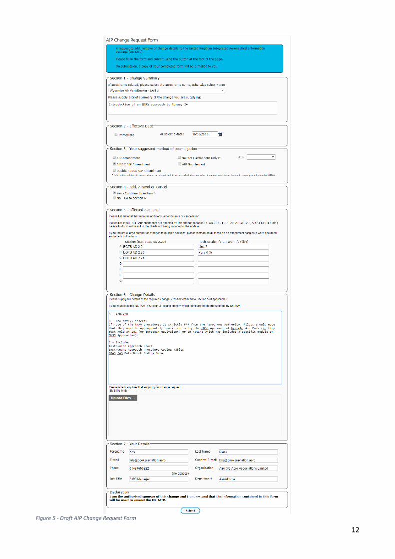
1. Avoid flying over the built-up areas of Chesham and Amersham wherever possible. 2. Separation of the proposed Denham and Wycombe IAPs
The design process has seen cooperation between Denham and Wycombe to ensure that both aerodromes’ proposed procedures do not conflict
3. Redesign for avoidance of existing Noise Abatement Zones Choosing not to implement the procedure would result in remaining with the current operation and being unable to improve the safety or efficiency of operations. This would also result in no improvement of safety with regards to the hazards associated with pilots continuing to make attempts to land at the airfield in marginal weather conditions.
Airspace Description The proposal is regarding the introduction of an RNAV approach to the north east of Wycombe Air Park. There are no proposed changes to the existing airspace structure. The
5
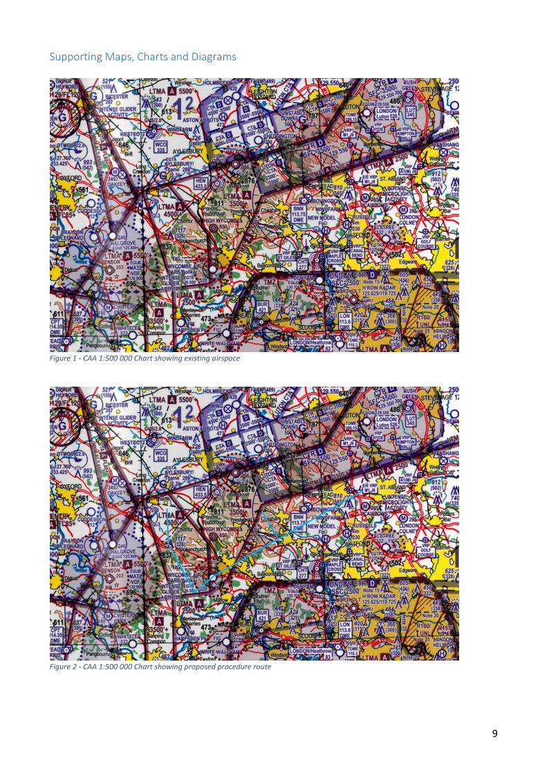
entire procedure will be contained within Class G airspace, clear of all controlled airspace (TMAs and CTAs). There are no proposed connections/interfaces to the existing Airway/En-Route structures. Figure 1 (page 9) shows the existing airspace structure on a CAA 1:500 000 chart. The ATZ hours of operation remain the same as those currently published in the UK AIP. Operations are 7 days a week: Winter: 0900-1730. Summer: 0800-1630 or Sunset, whichever is earlier. By local arrangement, hours may be extended: Winter: Tue-Thu and Public Holidays 1730-1900. Summer: Tue, Thu, Sat, Sun and Public Holidays 1630-1900. The existing volume of visual traffic will make integration of participating instrument traffic difficult, therefore the volume of visual traffic will need to be managed if the approach is to be utilised at peak times. As the approach is being implemented to enable approach operations in marginal weather conditions the majority of approaches will be conducted when the weather is poor and thus the volume of visual traffic naturally low. Wycombe Air Park holds an Aerodrome Licence (Ordinary) which requires persons using the aerodrome to be specifically authorised by the Licence Holder, commonly known as Prior Permission Required or PPR. The utilisation of a PPR slot booking system for aircraft wishing to fly the approach will enable the Air Traffic Controllers to anticipate arrivals and when they will need to restrict visual traffic and thus manage their workload. There are currently no Letters of Agreement or Memoranda of Understanding in existence with neighbouring ATSUs in relation to this proposal. The proposed approach has been designed by a Civil Aviation Authority (CAA) approved Instrument Approach Procedure (IAP) Designer, gCap Ltd, in accordance with International Civil Aviation Organisation (ICAO) document 8168, CAA policy and guidelines, and are in line with CAA best practices and standards in the UK. A Procedure Design Sign-Off is included in the submitted procedure design report. There is no proposed change to the existing classification of the airspace, Class G. As part of the implementation plan it is intended to restrict access to Booker Aviation Company aircraft for a pre-determined period of time before making the procedure available for Wycombe Air Park based aircraft. Following an operational review the procedure will be made available to all users. There is no intention to delegate ATS at this time.
Supporting Infrastructure/Resources The proposed procedure has LNAV and LPV minimas. There is an EGNOS Working Agreement in place to ensure the airfield is made aware of any unserviceability of the satellite system planned or unplanned.
6
In the event that an aircraft is unable to conduct an approach (instrument or visual) at Wycombe Air Park there are several airfields nearby with Instrument Landing Systems, and lower minima, that could be used as an alternative. The SSR code 3637 has been allocated to Wycombe Air Park to be used solely for conspicuity of participating aircraft. The ATC Unit at Wycombe Air Park currently has 1 full time ATCO who is enrolled on the Unit’s ADI training plan. We are currently undergoing a recruitment drive with the intention of having 3 full time ATCOs in place by implementation. All new recruits will be enrolled onto the ADI training plan and will hold an Assessment of Previous Competency where necessary. Wycombe Air Park have employed the services of SafeSkys Limited to manage the recruitment process of new ATCOs with the intention of them becoming the Air Navigation Service Provider prior to implementation thereby ensuring ongoing availability of sufficient suitable air traffic resources. SafeSkys’ ANSP Designation is currently pending approval with CAA. ATC Procedures will be developed in cooperation with the ATS Inspectors. Once the ATC Procedures have been developed they will be incorporated into MATS Part 2 and the ADI training plan before being submitted for approval by the ATS Inspector.
Operational Impact Impact along the proposed track The proposed procedure does not restrict the flow of traffic within the vicinity of the track as it is located in Class G airspace. It is however necessary to address, in the Safety Case, the fact that the route is located in a corridor of airspace, below the London TMA and between the London and Luton CTRs, which is very busy with GA traffic. Impact on or around the aerodrome When the procedure is in use in IMC (specifically low cloud base at the aerodrome) there will be little impact on the activity of other airfield users as the visual circuit and gliders would not be operating at these times. This is the reason we are proposing this change; there will in fact be a positive impact because appropriately equipped aircraft will be able to fly when they currently would be unable to do so because there is no published procedure to return to the airfield. This will be a different matter during VMC conditions when the gliders, helicopters and fixed wing visual circuit are busy. At these times it will be necessary for Air Traffic Control to restrict the volume of traffic operating in the ATZ, particularly the fixed wing circuit. In order to manage the impact that this has, a slot booking system will be operated and the volume of approaches severely restricted during good weather.
7
Whilst there will be no direct impact on gliding activity, it will be necessary to make pilots flying the approach aware that in VMC there may be gliders in the vicinity of the missed approach track. This is being addressed in the Safety Case. There is no impact on helicopter activity in VMC, in IMC it maybe necessary to height restrict or instruct helicopters to remain on the ground whilst an aircraft is on the approach. This is being addressed in the Safety Case.
Safety Management Wycombe Air Park and Wycombe Air Traffic operate Safety Management Systems in line with the requirements of their respective Licences/Approvals. The implementation of this proposal will be Change Managed in accordance with the existing manuals. Implementation and ongoing review will be subject to the oversight and guidance of the Safety Review Board and relevant Action/Working Groups. Full reporting transparency is achieved between Aerodrome and Air Traffic thereby enabling all safety hazards to be captured and assessed throughout the implementation and operational review process. Wycombe Air Park has employed the services of Nu Approach Ltd to manage the production of the Safety Case for this proposal. Nu Approach was selected for their experience in the implementation of RNAV Approaches.
Airspace and Infrastructure Requirements This application is in accordance with the CAP1122 framework and therefore Wycombe Air Park does not have an Approach Control Service or Radar. The entire procedure is contained in Class G airspace; no changes to this or new sections of airspace are being proposed. Air Traffic Control procedures will be developed to manage the integration of instrument traffic into the existing visual environment inside the Wycombe Air Park ATZ. Because the airspace remains Class G, there will no change to airspace accessibility. Where ATC are made aware of an unserviceability of the satellite system or a pilot reports an integrity alert this information will be promulgated by the fastest means possible for example directly to pilots on frequency, station broadcasts and/or NOTAM. Notification of the new approach will be made via the AIRAC cycle and subsequently published in the UK Aeronautical Information Publication. This will also enable timely inclusion into navigation databases. To further increase awareness to airspace users it is requested that IAP feathered approach cones are added to relevant CAA Charts (1:250 000 and 1:500 000). The current target for implementation is November 2018. A specific date/AIRAC cycle and reserve have not yet been agreed with SARG due to delays in the CAP1122 approval

8
framework. A target date will be agreed in writing upon commencement of the 16 week regulatory decision stage. The entire procedure is covered by the existing Wycombe Tower DOC 25nm/4000ft, therefore sufficient coverage exists. Coverage will be checked, and any issues identified during procedure flight validation. The interaction of the proposed procedure with existing gliding activity within the ATZ is being assessed in the Safety Case. EGNOS have confirmed that sufficient satellite coverage exists in the area of operation for an LPV approach. A Working Agreement has been signed to ensure that the Aerodrome/Air Traffic Control are made aware of any system outages whether planned or unplanned. There are no links to existing airspace structures.
9
Supporting Maps, Charts and Diagrams
Figure 1 - CAA 1:500 000 Chart showing existing airspace
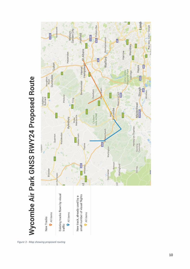
Figure 2 - CAA 1:500 000 Chart showing proposed procedure route
10
Figure 3 - Map showing proposed routing

Approach Chart Redacted
12
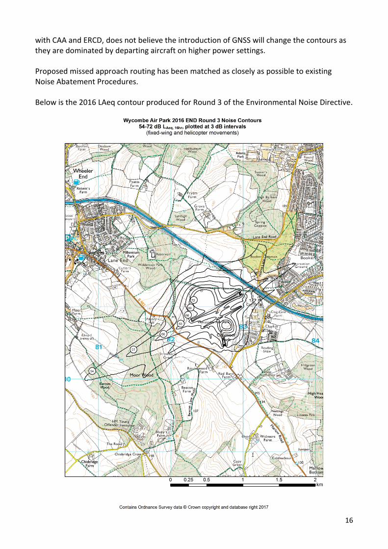
Figure 5 - Draft AIP Change Request Form

13
UK AIP pages requiring amendment as a result of this change: AD 2.EGTB-1 Section EGTB AD 2.2 Line 7 – inclusion of IFR AD 2.EGTB-5 Section EGTB AD 2.20 Para 4 – new item (f) AD 2.EGTB-6 Section EGTB AD 2.24 – inclusion of new charts

14
3. Environmental Report
Description of the Airspace Change As detailed in the Operational Report, Wycombe Air Park assessed the viability of several different types of instrument approach procedure before settling on an RNAV approach, specifically Approach with Vertical Guidance. We then went through several revisions of the draft designs to ensure that we avoided overflight of as many built up areas as possible and also that the missed approach track did not enter the existing noise abatement zones. This process resulted in one possible option which was put to consultation along with the option to do nothing. There are no proposed changes to the existing airspace structure. The introduction of an instrument approach procedure defined by the coordinates below is the only change proposed. Procedure Coordinates Initial Approach Fixes: NUNKU - 514348.21N 0004031.45W ELPIM - 514506.61N 0002234.29W Intermediate & Final Approach Fixes: TB24I - 514015.86N 0003732.50W TB24F - 513822.11N 0004322.61W Missed Approach Point RW24 – 513647.75N 0004812.74W Missed Approach Track TBM01 - 513522.87N 0005108.97W TBM02 - 513948.92N 0005600.71W TBM03 - 514323.82N 0005600.85W Because the proposed procedure includes both lateral and vertical guidance it is expected that no dispersal will occur outside of the required navigation performance.
Traffic Forecasts Wycombe Air Park do not currently have a published instrument approach and therefore in the absence of existing data have had to estimate the volume of traffic that will need to fly an instrument approach. This has been derived from the volume of instrument training conducted by Booker Aviation allowing a margin for private aircraft and future growth. Wycombe Air Park handled a total of 41,493 movements in 2016. This is the total movements made to/from runways (i.e. arrivals and departures). Helicopter and Glider movements are not included as their operations are different and not part of this proposal. See Table 1 for a

16
with CAA and ERCD, does not believe the introduction of GNSS will change the contours as they are dominated by departing aircraft on higher power settings. Proposed missed approach routing has been matched as closely as possible to existing Noise Abatement Procedures. Below is the 2016 LAeq contour produced for Round 3 of the Environmental Noise Directive.

17
An Assessment of the Change in Fuel Burn/CO2 Following engagement with the Aerodrome’s key aviation stakeholders, (i.e. pilots, air traffic controllers, other airspace users and airport operations staff) there is a consensus that the GNSS approach will allow aircraft to fly an optimal approach with lower engine power settings. The current approach that is used for arrivals onto runways requires pilots to follow a visual approach into the aerodrome. Once the pilot has the airfield in sight, they will be required to make a turn to align with the runway. When an aircraft begins to turn, a higher engine setting maybe required to maintain airspeed and thus increase CO2 emissions, fuel burn and noise. The proposed GNSS approach will allow aircraft to fly in a straight line over the ground and to land with minimal alterations to their direction of travel and engine settings. This type of approach will allow pilots to configure the aircraft more efficiently and potentially minimise fuel burn, CO2 and noise during the approach.
An Assessment of the Effect on Local Air Quality The airfield has considered the effects the proposed change may have on local air quality and in particular the effect on local air quality in the area surrounding the aerodrome below 1,000ft. The airfield has concluded that there is no net change in air quality as there is no increase in aircraft movements as a direct result of this proposal. The number of individual aircraft movements under the new GNSS proposals by small, light aircraft is so small in absolute terms that the impact is believed to be negligible.


20
The CAA have allocated Wycombe Air Park a conspicuity squawk (3637) which will be utilised solely for aircraft flying the proposed approach. This will allow other units to identify the traffic as flying the approach and pass safety critical traffic information to aircraft they are controlling.
“It is understood that it is proposed to operate the new procedure only during normal park opening hours. These are advertised as seven days a week from 09:00 to 17:30 and extended in the summer on Saturdays, Sundays, Tuesdays and Thursdays from 9:00 to 20:00. In winter night flying takes place until 19:00 on a Tuesday. This automatically limits the potential noise impact and [***] recommends that a condition of use be that the route can only be operated between the hours 08:00 and 20:00 daily.”
In order for the Aerodrome to operate the approach safely in conjunction with its Air Traffic Control service the approach will only be available for authorised use during the operating hours as published in the UK AIP. It is however important to highlight that this does not mean that there will be an absence of other traffic outside of the operating hours.
Objections to the Proposal Of the 62 responses received 9 were in support of Option B – Do Nothing
0%
100%
0%
RESPONDENTS IN FAVOUR OF OPTION B
Consultees Local Residents/Members of the Public Airfield Users

21
We have thoroughly analysed the responses received in objection to the proposal and have identified the following recurring issues.
“Your consultation as set out will involve additional overflights by aircraft across the hilltop Villages of Hyde Heath and south Heath creating an additional, cumulative and severe impact. Your consultation has failed to illustrate the impact on these villages and has failed to take into consideration the cumulative impact of noise from this proposal together with the noise of the High Sleed Train currently set to be constructed and noise from additional overflights should the 3rd runway at Heathrow be constructed.”
Whilst the proposed flight track does take aircraft close to villages to the north west of Amersham the aircraft on this section will be no lower than 2200ft altitude. The proposed route provides a safety margin between the corner of the Luton CTA next to the A41 where there is known to be a high density of traffic. This part of the track also originally overflew Chesham, Chesham Bois and Amersham and was moved to the proposed route during the early stages of development in order to avoid overflight of the greatest number of houses possible. There is no requirement as part of the Airspace Change Proposal to take into account cumulative effects of third-party projects of which details are not yet available.
“I would only support it if you guarantee no early/late low level flights over Marlow Bottom where your traffic is too low early evening way too often!”
The overflight of Marlow Bottom is outside the scope of this consultation because it is not in proximity to the proposed routing.
“The only occasions when we are able to enjoy our environment free from the racket made by aircraft, (particularly glider tugs), are at times of poor visibility. If these navigation aids are introduced, the Consultation Document readily admits that there will not only be aircraft noise during periods of low visibility, but there will be an increase of air traffic concentrated into a narrow flight path over our residential area at all times.”
As stated in the consultation document there will be an increase in traffic during periods of low visibility, however, the volume will be nowhere near the levels of traffic seen when operating circuits on a busy good weather day.
“…if aircraft are approaching the runway and are relying on this navigation aid at times of poor weather, there is an increased chance of a serious accident with dire consequences for people in Cressex and residential areas
22
in South East Wycombe if there is a technical failure of the navigation system.”
The use of GNSS as a navigation aid particularly when using a Satellite Based Augmentation System (EGNOS) to check the accuracy of the satellite data received is of far higher safety margins to the alternative options. In addition to the accuracy of the system, pilots flying the proposed approach will have received specific training, in the format of an Instrument Rating, to fly this type of approach and what to do in the event of a data integrity failure. Wycombe Air Park has also signed an EGNOS Working Agreement which will ensure that advanced notification is received of any planned system outages at which point the approach will be notified as unavailable.
“I don't think the impact has been fairly described. The additional flight operations have been averaged out over a complete year, where in fact they will be concentrated on the days where conditions suit instrument only flying”
Whilst the overall impact has been averaged out over the year the number of movements when the approach is in use will be lower than when the circuit is in use on a busy good weather day therefore the impact on days suited to instrument only flying will still remain low.
“You need to get an independent environmental impact assessment done not just declare yourself it has no impact. This is being deliberately misleading. Chesham is already used a stacking area for heathrow and is the largest town in the Chilterns district and also the most densely populated when you consider Amersham. Therefore this levels of airplane noise is already exceeding acceptable environment levels for residents. You provided no details as to how you are going to mitigate the damage airplane noise is having or how you are going to reduce the flying over of residential properties in Chesham. Airplane noise is damaged to the health is already linked to high rate of diabetes. Have you specifically consulted with Buckinghamshire County, Chiltern District and Chesham Town Council's.”
The requirement for this Airspace Change Proposal was assessed and agreed with the Civil Aviation Authority at the Framework briefing on 25th October 2016 in line with CAP725 - Airspace Change Process Guidance Document. The environmental impacts of this proposal were discussed alongside the existing noise contours published in the Wycombe Air Park Noise Management and Action Plan. As a result the impact was deemed sufficiently low to not require an independent environmental impact assessment or the production of separate noise contours.
Key stakeholders, identified in Appendix A, including County, District/Borough and Town Councils overflown by the proposed route have been invited to respond to the consultation.

23
Numerous comments were made regarding the use of the proposed approach by helicopters.
The consultation is not about existing helicopter operations and circuits as these do not utilise the same routing as the proposal. Whilst it is possible for helicopters to fly the approach and this will not be ruled out, it is not expected to be a regular occurrence as there are very few helicopters based at the airfield that are approved for instrument flight. It is also likely that the minima for the approach will be in excess of the minima for their existing operations and therefore will not be of any significant advantage.
A local residents association, whilst appearing to not be completely against the proposal, expressed concerns that no further public consultation would be required for future aerodrome expansion post implementation.
This consultation is only regarding the implementation of the proposed approach and is required under the guidance set out in CAP725 - Airspace Change Process Guidance Document. The respondent identifies that consultation would not be required under the same guidance and framework in order to make operational changes to the aerodrome. The scenarios used by the respondent are runway extension and extensions to operating hours. Whilst this would not fall under the remit of CAP725 it would be up to the Aerodrome’s landlord (Wycombe District Council) to approve any operational changes. It is not known whether the landlord would choose to consult if these decisions were required. It is important to note that the Aerodrome Operator is not currently considering these options and that they have been raised by a respondent.
Concerns were raised regarding increases in future movements following wider adoption of GNSS technology
It is important to note that the majority of flying at Wycombe Air Park is ab-initio flight training which requires pilots to fly by visual reference to the ground and not using instruments. This is very unlikely to change and as such the aerodrome needs to maintain the existing level of visual operations. In order to significantly increase beyond the volume of proposed approaches the aerodrome would need to implement an Approach Control Service and potentially Radar. The cost of this would far outweigh any potential return on investment and the volume of visual operations would still need to decrease beyond existing levels. It is for this reason that even if all aircraft at the airfield were GNSS equipped the majority of operations would remain visual and that the use of the proposed approach will be mostly on poor weather days when visual operations are not possible.
Modifications to the Proposal No changes to the proposed route were identified as part of the consultation or in order to address any of the concerns made by respondents.

24
All safety hazards identified as part of the consultation have been fed into the production of the Safety Case and therefore may result in operational procedure changes during their development.
25
Appendix A - Supporting Documentation The following supporting documents are included in this appendix in the following order:
• Consultation Document
• Consultation Response Log
• Copies of paper responses received
• Copies of correspondence sent and received during the consultation
• Consultation Action Log
• Newspaper Advert/Notice Poster
• Minutes of meetings where the consultation was discussed
• Attendance record sheets from drop-in sessions
• A map showing the location of respondents in favour of Option B – Do Nothing
• Record of Action with Named Consultees
• Consultation Feedback Report


![0E 0I] *IHIVEP HI 'MRIQEXSKVEJuE E EySW HI WY VIJSVQE · 0e 0i] *ihivep hi 'mriqexskvejue e eysw hi wy vijsvqe 4vmqiv gspsuyms 9rmzivwmxevms hi %rjpmwmw 'mriqexskvjjmgs ` 'myheh hi](https://static.fdocuments.in/doc/165x107/602341a3a0ee2839c479f9e8/0e-0i-ihivep-hi-mriqexskvejue-e-eysw-hi-wy-vijsvqe-0e-0i-ihivep-hi-mriqexskvejue.jpg)