WSSS (Changi) WSSS (Changi)
35
JEPPESEN JEPPESEN JEPPESEN JEPPESEN JeppView 3.5.2.0 WSSS (Changi) Airport Information General Info Singapore, SGP N 01° 21.6' E103° 59.4' Mag Var: 0.0°W Elevation: 22' Public, Control Tower, IFR, No Fee, Low Level Wind Shear Alert System, Rotating Beacon, No Customs Fuel: Jet A-1 Repairs: Major Airframe, Major Engine Time Zone Info: GMT+8:00 no DST Runway Info Runway 02C-20C 13123' x 197' bitu Runway 02L-20R 13123' x 197' bitu Runway 02C (23.0°M) TDZE 14' Lights: Edge, ALS, Centerline, REIL Stopway Distance 197' Runway 02L (23.0°M) TDZE 22' Lights: Edge, ALS, Centerline, REIL, TDZ Stopway Distance 197' Runway 20C (203.0°M) TDZE 15' Lights: Edge, ALS, Centerline, REIL, TDZ Stopway Distance 197' Runway 20R (203.0°M) TDZE 13' Lights: Edge, ALS, Centerline, REIL Displaced Threshold Distance 2428' Stopway Distance 197' Communications Info ATIS 128.6 Singapore Tower 118.25 Singapore Tower 118.6 Singapore Ground Control 124.3 Singapore Ground Control 121.725 Singapore Ground Control 121.85 Singapore Clearance Delivery 121.65 Singapore Pre-Taxi Clearance 121.65 Singapore Approach Control 124.6 Secondary Singapore Approach Control 120.3 Singapore Arrival Control 119.3 Singapore Radar 124.05 Arrival Service JEPPESEN JEPPESEN JEPPESEN JEPPESEN JeppView 3.5.2.0 WSSS (Changi) Airport Information Notebook Info
Transcript of WSSS (Changi) WSSS (Changi)
JEPPESENJEPPESENJEPPESENJEPPESEN
JeppView 3.5.2.0WSSS (Changi)Airport Information
General InfoSingapore, SGPN 01° 21.6' E103° 59.4' Mag Var: 0.0°WElevation: 22'
Public, Control Tower, IFR, No Fee, Low Level Wind Shear Alert System,Rotating Beacon, No CustomsFuel: Jet A-1Repairs: Major Airframe, Major Engine
Time Zone Info: GMT+8:00 no DST
Runway InfoRunway 02C-20C 13123' x 197' bituRunway 02L-20R 13123' x 197' bitu
Runway 02C (23.0°M) TDZE 14' Lights: Edge, ALS, Centerline, REIL Stopway Distance 197'Runway 02L (23.0°M) TDZE 22' Lights: Edge, ALS, Centerline, REIL, TDZ Stopway Distance 197'Runway 20C (203.0°M) TDZE 15' Lights: Edge, ALS, Centerline, REIL, TDZ Stopway Distance 197'Runway 20R (203.0°M) TDZE 13' Lights: Edge, ALS, Centerline, REIL Displaced Threshold Distance 2428' Stopway Distance 197'
Communications InfoATIS 128.6Singapore Tower 118.25Singapore Tower 118.6Singapore Ground Control 124.3Singapore Ground Control 121.725Singapore Ground Control 121.85Singapore Clearance Delivery 121.65Singapore Pre-Taxi Clearance 121.65Singapore Approach Control 124.6 SecondarySingapore Approach Control 120.3Singapore Arrival Control 119.3Singapore Radar 124.05 Arrival Service
JEPPESENJEPPESENJEPPESENJEPPESEN
JeppView 3.5.2.0WSSS (Changi)Airport Information
Notebook Info
Licensed to max. P
rinted on 22 Jun 2008.
Notice: A
fter 4
Jul 2008 0901Z, th
is chart m
ay no longer b
e valid. D
isc 12-2008
JE
PP
ES
EN
JeppView 3.5.2.0
244^ 252^
235^
243^
220^
D57.3
D43.6
D38.6
D24.0
D11.6
COMMS
LOST
COMMS
LOST
COMMS
LOST
COMMSLOST COMMSLOST COMMSLOST COMMSLOST COMMSLOST
COMMS
LOST
COMMS
LOST
LOST
17 NM
CHANGES:
JEPPESEN
WSSS/SIN
CHANGI
SINGAPO
RE, SINGAPO
RE
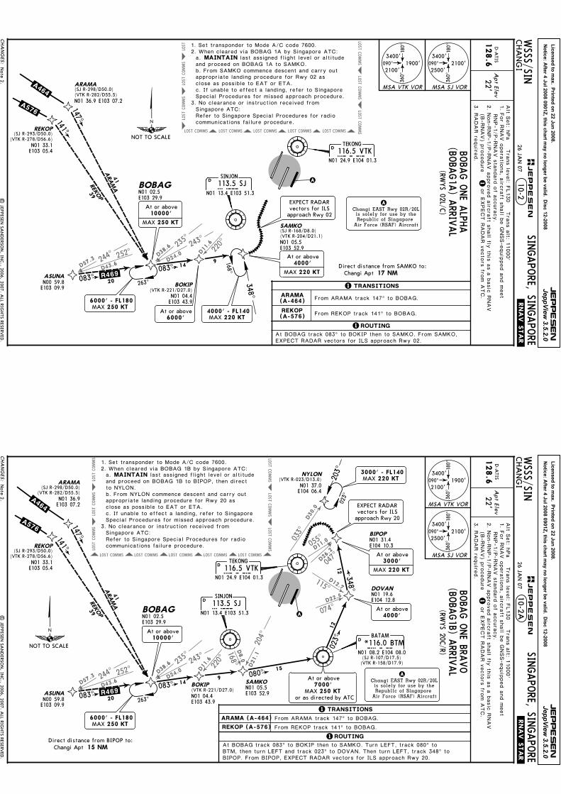
TEKONG
116.5 VTKVTKN01 24.9 E104 01.3
D
A
Apt E
lev
22'1
1ROUTING
and proceed on BOBAG 1A to SAMKO.
10-2.RNAV.STA
R.
Alt S
et: h
Pa T
rans level: F
L130 T
rans alt: 1
1000'
D-A
TIS
128.6
3. R
ADAR re
quired.
From ARAMA track 147^ to BOBAG.
From REKOP track 141^ to BOBAG.
2. When cleared via BOBAG 1A by Singapore ATC:MAINTAIN
N01 33.1E103 05.4
REKOP(SJ R-293/D50.0)
(VTK R-278/D56.6)
147^141^
083^083^
ASUNA
N00 59.8E103 09.9
BOBAGN01 02.5E103 29.9
BOKIP(VTK R-221/D27.0)
N01 04.4E103 43.9
SAMKO
N01 05.5E103 52.9
263^
6000' - FL180MAX 250 KT
ARAMA
REKOP
41
39
20
149
SINJON
113.5 SJSJN01 13.4 E103 51.3
D
1. Set transponder to Mode A/C code 7600.
last assigned flight level or altitude
appropriate landing procedure for Rwy 02 as close as possible to EAT or ETA.
Special Procedures for missed approach procedure.
b. From SAMKO commence descent and carry out
a.
c. If unable to effect a landing, refer to Singapore
3. No clearance or instruction received from Singapore ATC:Refer to Singapore Special Procedures for radio communications failure procedure.
ARAMA(SJ R-298/D50.0)(VTK R-282/D55.5)
Changi AptDirect distance from SAMKO to:
Changi EAST Rwy 02R/20Lis solely for use by theRepublic of Singapore
Air Force (RSAF) Aircraft
A
(SJ R-168/D8.0)(VTK R-204/D21.1)
4000' - FL140 220 KTMAX
348^
168^
At or above
MAX 220 KT
4000'
EXPECT RADARvectors for ILSapproach Rwy 02
At or above
MAX 250 KT
10000'
090^
180^
360^
3400'
2500'2100'090^
180^
360^
3400'
2100'1900'
MSA VTK VOR MSA SJ VOR
(RWYS 02L/C
)
1 TRANSITIONS
EXPECT RADAR vectors for ILS approach Rwy 02.At BOBAG track 083^ to BOKIP then to SAMKO. From SAMKO,
N01 36.9 E103 07.2
.A464..A576.
.R469.
1. For R
NAV operations, aircraft s
hall b
e GNSS-equipped and meet
RNP-1/P-RNAV standard of a
ccuracy.
or E
XPECT RADAR vectors fro
m ATC.
BOBA
G O
NE A
LPHA
(BOBA
G1A
) ARRIV
AL
26 JAN 07
At or above6000'
ARAMA(A-464)
REKOP(A-576)
Note 2.
| JEPPESEN
SANDERSO
N, IN
C., 2006, 2007. A
LL RIGHTS RESERV
ED.
2. N
on-RNP-1/P-RNAV approved aircraft s
hall fly
this as a basic RNAV
(B-RNAV) p
rocedure
NOT TO SCALE
Licensed to max. P
rinted on 22 Jun 2008.
Notice: A
fter 4
Jul 2008 0901Z, th
is chart m
ay no longer b
e valid. D
isc 12-2008
JE
PP
ES
EN
JeppView 3.5.2.0
244^ 252^
235^
243^
220^
168^
204^
115^
074^
055^
047^
033^
D57.3
D43.6
D38.6
D24.0
D11.6
D21.1
D8.0
D12.7
D22.5
D11.0
D26.2
D30.0
COMMS
LOST
COMMS
LOST
COMMS
LOST
COMMSLOST COMMSLOST COMMSLOST COMMSLOST COMMSLOST
COMMS
LOST
COMMS
LOST
COMMS
LOST
15 NM
CHANGES:
JEPPESEN
WSSS/SIN
CHANGI
SINGAPO
RE, SINGAPO
RE
TEKONG
116.5 VTKVTKN01 24.9 E104 01.3
D
A
Apt E
lev
22'1
Changi EAST Rwy 02R/20Lis solely for use by theRepublic of Singapore
Air Force (RSAF) Aircraft
A
.RNAV.STA
R.
Alt S
et: h
Pa T
rans level: F
L130 T
rans alt: 1
1000'
D-A
TIS
128.6
3. R
ADAR re
quired.
2. When cleared via BOBAG 1B by Singapore ATC:MAINTAIN
1ROUTING
From ARAMA track 147^ to BOBAG.
From REKOP track 141^ to BOBAG.
023^
BTM, then turn LEFT and track 023^ to DOVAN. Then turn LEFT, track 348^ to BIPOP. From BIPOP, EXPECT RADAR vectors for ILS approach Rwy 20.
3000' - FL140MAX 220 KT
N01 33.1E103 05.4
REKOP(SJ R-293/D50.0)
(VTK R-278/D56.6)
147^141^
083^083^
080^
023^
348^
ASUNA
N00 59.8E103 09.9
BOBAGN01 02.5E103 29.9
BOKIP(VTK R-221/D27.0)N01 04.4E103 43.9
SAMKON01 05.5E103 52.9
DOVANN01 19.6E104 12.8
BIPOP
N01 31.4E104 10.3
At or above
MAX 220 KT
3000'
NYLON(VTK R-023/D13.0)
N01 37.0E104 06.4
263^
6000' - FL180MAX 250 KT
203^
ARAMA
REKOP
41
39
20
149
15
12
12
SINJON
113.5 SJSJN01 13.4 E103 51.3
D
BATAM
*116.0 BTMBTMN01 08.2 E104 08.0
D
1. Set transponder to Mode A/C code 7600.
last assigned flight level or altitude
appropriate landing procedure for Rwy 20 as close as possible to EAT or ETA.
Special Procedures for missed approach procedure.
b. From NYLON commence descent and carry out
a.
c. If unable to effect a landing, refer to Singapore
3. No clearance or instruction received from Singapore ATC:Refer to Singapore Special Procedures for radio communications failure procedure.
ARAMA(SJ R-298/D50.0)
(VTK R-282/D55.5)N01 36.9E103 07.2
Changi AptDirect distance from BIPOP to:
and proceed on BOBAG 1B to BIPOP, then direct to NYLON.
10-2A
090^
180^
360^
3400'
2500'2100'
090^
180^
360^
3400'
2100'1900'
MSA VTK VOR
MSA SJ VOR
(RWYS 20C
/R)
EXPECT RADARvectors for ILSapproach Rwy 20
(SJ R-107/D17.5)(VTK R-158/D17.9)
1 TRANSITIONS
At BOBAG track 083^ to BOKIP then to SAMKO. Turn LEFT, track 080^ to
.R469.
.A576.
.A464.
1. For R
NAV operations, aircraft s
hall b
e GNSS-equipped and meet
RNP-1/P-RNAV standard of a
ccuracy.
BOBA
G O
NE BRA
VO
(BOBA
G1B) A
RRIVAL
or E
XPECT RADAR vectors fro
m ATC.
26 JAN 07
At or above 10000'
At or above
MAX 250 KT7000'
or as directed by ATC
At or above4000'
ARAMA (A-464)
REKOP (A-576)
Note 2.
| JEPPESEN
SANDERSO
N, IN
C., 2006, 2007. A
LL RIGHTS RESERV
ED.
2. N
on-RNP-1/P-RNAV approved aircraft s
hall fly
this as a basic RNAV
(B-RNAV) p
rocedure
NOT TO SCALE
Licensed to max. P
rinted on 22 Jun 2008.
Notice: A
fter 4
Jul 2008 0901Z, th
is chart m
ay no longer b
e valid. D
isc 12-2008
JE
PP
ES
EN
JeppView 3.5.2.0
COMMS
LOST
COMMS
LOST
COMMS
LOST
COMMSLOST COMMSLOST COMMSLOST COMMSLOST COMMSLOST
COMMS
LOST
COMMS
LOST
COMMS
LOST
096^ D36.2
120^ D30.0
D8.0
168^
14 NM
CHANGES:
JEPPESEN
WSSS/SIN
CHANGI
SINGAPO
RE, SINGAPO
RE
TEKONG116.5 VTKVTK
N01 24.9 E104 01.3
D
A
Apt E
lev
22'1
Changi EAST Rwy 02R/20Lis solely for use by theRepublic of Singapore
Air Force (RSAF) Aircraft
A
.RNAV.STA
R.
Alt S
et: h
Pa T
rans level: F
L130 T
rans alt: 1
1000'
D-A
TIS
128.6
3. R
ADAR re
quired.
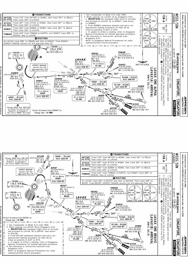
2. When cleared via LAVAX 1A by Singapore ATC:MAINTAIN
1 ROUTING
1. Set transponder to Mode A/C code 7600.
last assigned flight level or altitude
appropriate landing procedure for Rwy 02 as close as possible to EAT or ETA.
Special Procedures for missed approach procedure.
b. From SAMKO commence descent and carry out
a.
c. If unable to effect a landing, refer to Singapore
3. No clearance or instruction received from Singapore ATC:Refer to Singapore Special Procedures for radio communications failure procedure.
Changi AptDirect distance from SANAT to:
and proceed on LAVAX 1A to SANAT, then direct to SAMKO.
10-2B
GOBIK
TOMAN
Track 316^ from AKTOD to IKIMA, then track 291^ to IBULA. Then track 335^ to LAVAX.
Track 233^ from TOMAN to KARTO, turn RIGHT track 269^ to KEXAS, then to LAVAX.
283^297^
316^
291^
335^
233^
269^
195
21
20
17
4621
90
94
TOMAN
GOBIKATVIXAKTOD
090^
180^
360^
3400'
2500'2100'
090^
180^
360^
3400'
2100'1900'
MSA VTK VOR
MSA SJ VOR
N01 09.8E104 27.2
LAVAX N01 10.3E104 48.3
(VTK R-107/D49.2)
KEXAS(SJ R-093/D57.2)
N00 50.6E104 36.0
(VTK R-135/D48.7)
IBULA(SJ R-117/D50.2)
IKIMA(SJ R-115/D70.5)
(VTK R-128/D67.9)N00 43.2 E104 55.0
AKTOD(SJ R-127/D161)
S00 24.8 E105 59.6(VTK R-133/D161)
GOBIK(SJ R-106/D266)
(VTK R-109/D259)N00 00.0 E108 06.1
ATVIX(SJ R-116/D160)(VTK R-122/D157)N00 02.4 E106 14.9
089^ 089^
111^
FL150 - FL250MAX 250 KT
291^
269^
KARTO(SJ R-091/D103)
N01 11.4 E105 33.7(VTK R-098/D93.5)
TOMAN(SJ R-086/D117)
N01 21.8 E105 47.3(VTK R-092/D106)
SINJON113.5 SJSJ
N01 13.4 E103 51.3
D
168^
348^
4000' - FL140 220 KTMAX
IGNON(SJ R-102/D22.2)(VTK R-144/D19.8)N01 08.8E104 13.0
SANAT(SJ R-124/D9.9)(VTK R-186/D17.1)N01 07.8E103 59.5
At or above4000'
266^1414
(RWYS 02L/C
)
1 TRANSITIONS
Track 297^ from ATVIX to IKIMA, then track 291^ to IBULA. Then track 335^ to LAVAX.
Track 283^ from GOBIK to IKIMA, then track 291^ to IBULA. Then track 335^ to LAVAX.
At LAVAX track 266^ to IGNON and then to SANAT. From SANAT, EXPECT RADAR vectors for ILS approach Rwy 02.
SAMKO(VTK R-204/D21.1)
N01 05.5E103 52.9
.A464..A576.
FL260 - FL310MAX 280 KT
7000' - FL140MAX 220 KT
At or belowFL160EXPECT RADAR
vectors for ILSapproach Rwy 02
1. For R
NAV operations, aircraft s
hall b
e GNSS-equipped and meet
RNP-1/P-RNAV standard of a
ccuracy.
LAVAX O
NE A
LPHA
(LAVAX1A
) ARRIV
AL
or E
XPECT RADAR vectors fro
m ATC.
26 JAN 07
MAX 250 KT
At or above7000'
MAX 220 KT
AKTOD(A-576)
ATVIX(A-464)
At or belowFL180
Note 2.
| JEPPESEN
SANDERSO
N, IN
C., 2006, 2007. A
LL RIGHTS RESERV
ED.
(B-RNAV) p
rocedure
2. N
on-RNP-1/P-RNAV approved aircraft s
hall fly
this as a basic RNAV
NOT TO SCALE
Licensed to max. P
rinted on 22 Jun 2008.
Notice: A
fter 4
Jul 2008 0901Z, th
is chart m
ay no longer b
e valid. D
isc 12-2008
JE
PP
ES
EN
JeppView 3.5.2.0
074^
055^
033^
D22.5
D11.0
D30.0
COMMS
LOST
COMMS
LOST
COMMS
LOST
COMMSLOST COMMSLOST COMMSLOST COMMSLOST COMMSLOST
COMMS
LOST
COMMS
LOST
COMMS
LOST
096^
087^
D36.2
D28.6
15 NM
CHANGES:
JEPPESEN
WSSS/SIN
CHANGI
SINGAPO
RE, SINGAPO
RE
TEKONG116.5 VTKVTK
N01 24.9 E104 01.3
D
A
Apt E
lev
22'1
Changi EAST Rwy 02R/20Lis solely for use by theRepublic of Singapore
Air Force (RSAF) Aircraft
A
.RNAV.STA
R.
Alt S
et: h
Pa T
rans level: F
L130 T
rans alt: 1
1000'
D-A
TIS
128.6
3. R
ADAR re
quired.
2. When cleared via LAVAX 1B by Singapore ATC:MAINTAIN
1 ROUTING
023^
348^
DOVAN
BIPOP
N01 31.4E104 10.3
NYLON(VTK R-023/D13.0)
N01 37.0E104 06.4
203^
12
1. Set transponder to Mode A/C code 7600.
last assigned flight level or altitude
appropriate landing procedure for Rwy 20 as close as possible to EAT or ETA.
Special Procedures for missed approach procedure.
b. From NYLON commence descent and carry out
a.
c. If unable to effect a landing, refer to Singapore
3. No clearance or instruction received from Singapore ATC:Refer to Singapore Special Procedures for radio communications failure procedure.
Changi AptDirect distance from BIPOP to:
and proceed on LAVAX 1B to BIPOP, then direct to NYLON.
10-2C
GOBIK
TOMAN
At LAVAX track 304^ to RUTOT and then to DOVAN. Then track 348^ to BIPOP. From BIPOP, EXPECT RADAR vectors for ILS approach Rwy 20.
Track 316^ from AKTOD to IKIMA, then track 291^ to IBULA. Then track 335^ to LAVAX.
Track 233^ from TOMAN to KARTO, turn RIGHT track 269^ to KEXAS, then to LAVAX.
304^9
8
090^
180^
360^
3400'
2500'2100'090^
180^
360^
3400'
2100'1900'
MSA VTK VOR MSA SJ VOR
N01 14.9E104 19.8
RUTOT(VTK R-118/D21.0)
N01 09.8E104 27.2
LAVAX(VTK R-120/D30.0)
3000' - FL140MAX 220 KT
089^
SINJON
113.5 SJSJN01 13.4 E103 51.3
D
(RWYS 20C
/R)
Track 297^ from ATVIX to IKIMA, then track 291^ to IBULA.
Track 283^ from GOBIK to IKIMA, then track 291^ to IBULA.
Then track 335^ to LAVAX.
Then track 335^ to LAVAX.EXPECT RADARvectors for ILSapproach Rwy 20
(SJ R-047/D26.2)
21
335^
21
N00 50.6E104 36.0
(VTK R-135/D48.7)
IBULA(SJ R-117/D50.2)
7000' - FL140MAX 220 KT
N01 10.3E104 48.3
(VTK R-107/D49.2)
KEXAS(SJ R-093/D57.2)
269^46
233^
17
TOMAN
089^
269^
KARTO(SJ R-091/D103)
N01 11.4 E105 33.7(VTK R-098/D93.5)
TOMAN(SJ R-086/D117)
N01 21.8 E105 47.3(VTK R-092/D106)
283^297^
316^
19590 GOBIKATVIX
GOBIK(SJ R-106/D266)
(VTK R-109/D259)N00 00.0 E108 06.1
ATVIX(SJ R-116/D160)(VTK R-122/D157)N00 02.4 E106 14.9
FL150 - FL250MAX 250 KT
.A464.
FL260 - FL310MAX 280 KT
291^20
94AKTOD
IKIMA(SJ R-115/D70.5)
(VTK R-128/D67.9)N00 43.2 E104 55.0
AKTOD(SJ R-127/D161)
S00 24.8 E105 59.6(VTK R-133/D161)
111^291^
.A576.
At or belowFL160
N01 19.6 E104 12.8(VTK R-115/D12.7)
1 TRANSITIONS
1. For R
NAV operations, aircraft s
hall b
e GNSS-equipped and meet
RNP-1/P-RNAV standard of a
ccuracy.LA
VAX O
NE BRA
VO
(LAVAX1B) A
RRIVAL
or E
XPECT RADAR vectors fro
m ATC.
26 JAN 07
MAX 250 KT
At or above8000'
4000'At or above
At or above
MAX 220 KT
3000'
AKTOD(A-576)
ATVIX(A-464)
At or belowFL180
Note 2.
| JEPPESEN
SANDERSO
N, IN
C., 2006, 2007. A
LL RIGHTS RESERV
ED.
2. N
on-RNP-1/P-RNAV approved aircraft s
hall fly
this as a basic RNAV
(B-RNAV) p
rocedure
NOT TO SCALE

Licensed to max. Printed on 22 Jun 2008.
Notice: After 4 Jul 2008 0901Z, this chart may no longer be valid. Disc 12-2008
JEPPESEN
JeppView 3.5.2.0
COMMSLOST COMMSLOST COMMSLOST
COMMS
LOST
COMMS
LOST
COMMS
LOST
COMMS
LOST
COMMS
LOST
COMMS LOSTCOMMS LOSTCOMMS LOST
282^
274^
298^
296^
355^
326^
007^
033^
023^
D55.5
D36. 6
D30.0
D12.9
D17.2
D22.6
D13.2
D30.0
D13.0
VTK
116.5
14 NM
CHANGES:
JEPPESENWSSS/SINCHANGI
SINGAPORE, SINGAPORE
TEKONG
116.5
VTK
VTK
N01
24.9
E104
01.3
D
A
Apt Elev
22'1
Changi
EAST R
wy 0
2R/20L
is s
ole
ly f
or
use b
y t
he
Republi
c o
f Sin
gapore
Air
Forc
e (
RSAF)
Air
cra
ft
A
.RNAV.STAR.
Alt Set: hPa Trans level: FL130 Trans alt: 11000'
D-ATIS
128.6
3. RADAR required.
2. When cleared via LELIB 2B by Singapore ATC:
MAINTAIN
1ROUTING
023^
NYLON
N01
37.0
E104
06.4
203^
1. Set transponder to Mode A/C code 7600.
last assigned flight level or altitude
appropriate landing procedure for Rwy 20 as
close as possible to EAT or ETA.
Special Procedures for missed approach procedure.
b. From NYLON commence descent and carry out
a.
c. If unable to effect a landing, refer to Singapore
3. No clearance or instruction received from
Singapore ATC:
Refer to Singapore Special Procedures for radio
communications failure procedure.
ARAMA
(SJ R-29
8/D50
.0)
Cha
ngi Apt
Direc
t distan
ce from BID
US to:
and proceed on LELIB 2B to BIDUS, then direct
to NYLON.
10-2D
090^
180^ 360^
3400
'
2500
'21
00'
090^
180^ 360^
3400
'
2100
'19
00'
MSA VTK VOR
MSA SJ VOR
(RWYS 20C/R)
At LELIB, turn LEFT and track 082^ to JB. Then track 086^ to ALFA, then turn
LEFT and track 057^ to BIDUS. From BIDUS, EXPECT RADAR vectors for ILS
approach Rwy 20.
118^
082^
086^
057^
20
18
7
10
LELIB
N01
27.5
E103
24.8
N01
30.6
E103
49.7
ALFA
At or abo
ve6000'
N01
35.9
E103
57.9
BIDUS
3000' - FL140
MAX 220 KT
SINJO
N
113.5
SJSJ
N01
13.4
E103
51.3
D
JAYBE
E
400
JBJB
N01
30.0
E103
42.7
(SJ R-33
3/D18
.6)
(VTK
R-285
/D19
.3)
EXPE
CT RA
DAR
vectors for ILS
approa
ch Rwy 20
.A464.
N01
36.9
E103
07.2
1. For RNAV operations, aircraft shall be GNSS-equipped and meet RNP-1/P-RNAV standard of accuracy.
LELIB TWO BRAVO(LELIB2B) ARRIVAL
or EXPECT RADAR vectors from ATC.
10 AUG 07
At or abo
ve 10000'
At or abo
ve
250 KT
MAX7000'
At or abo
ve
220 KT
MAX3000'
| JEPPESEN SANDERSON, INC., 2006, 2007. ALL RIGHTS RESERVED.
2. Non-RNP-1/P-RNAV approved aircraft shall fly this as a basic RNAV(B-RNAV) procedure
None.
NOT TO
SCALE
Licensed to max. Printed on 22 Jun 2008.
Notice: After 4 Jul 2008 0901Z, this chart may no longer be valid. Disc 12-2008
JEPPESEN
JeppView 3.5.2.0
347^355^D90.2
D80.4
069^
D6.9
D9.9
D8.0
124^168^
COMMS
COMMS
LOST
COMMS
LOST
COMMS
LOST
COMMSLOST COMMSLOST COMMSLOST COMMSLOST
COMMSLOST COMMSLOST COMMSLOST COMMSLOST
14 NM
CHANGES:
JEPPESENWSSS/SINCHANGI
SINGAPORE, SINGAPORE
TEKONG
116.5 VTKVTKN01 24.9 E104 01.3
D
A
Apt Elev
22'1
Changi EAST Rwy 02R/20Lis solely for use by theRepublic of Singapore
Air Force (RSAF) Aircraft
A
.RNAV.STAR.
Alt Set: hPa Trans level: FL130 Trans alt: 11000'
D-ATIS
128.6
3. RADAR required.
MAINTAIN
1ROUTING
023^
NYLON
1. Set transponder to Mode A/C code 7600.
a.
3. No clearance or instruction received from Singapore ATC:
Changi AptDirect distance from SANAT to:
10-2E
SANAT. From SANAT, EXPECT RADAR vectors for ILS approach Rwy 02.
090^
180^
360^
3400'
2500'2100'090^
180^
360^
3400'
2100'1900'
MSA VTK VOR MSA SJ VOR
VEPLI
N03 52.4 E104 05.7(VTK R-002/D147)
SINJON
113.5 SJSJN01 13.4 E103 51.3
D
(RWYS 02L/C)
At PASPU track 180^ to NYLON then track 172^ to POSUB. Turn RIGHT and track 203^ to
At BIKTA track 120^ to PIBAP, then turn RIGHT and track 180^ to PASPU.
At VEPLI track 180^ to PIBAP then to PASPU.
At MABAL track 231^ to KILOT, then turn RIGHT to track 258^ to VINIL. Turn LEFT and track 180^ to PIBAP and then to PASPU.
348^
168^
180^180^
231^
258^
120^172^
203^
4235
57
27
25
31
22
10
21
MABAL
VEPLI
BIKTA
VINIL
MABAL
(VTK R-030/D142)N03 28.4 E105 12.6
KILOT
N03 02.3 E104 40.4PIBAP
N02 30.4 E104 06.3(VTK R-004/D65.3)(SJ R-011/D78.1)
BIKTAN02 43.6E103 43.1
(VTK R-008/D34.5)(SJ R-018/D48.1)PASPU
N01 59.3 E104 06.3
N01 37.0 E104 06.4
POSUB
N01 27.4 E104 07.8(SJ R-050/D21.7)
N01 07.8 E103 59.5
SANAT(VTK R-186/D17.1)
At or above4000'
360^360^
(VTK R-003/D89.8)(SJ R-009/D102)
051^
231^
(SJ R-024/D119)(VTK R-022/D104)
FL280 - FL350MAX 300 KT
N02 55.0E104 06.3
180^
203^
(VTK R-023/D13.0)(SJ R-033/D30.0)
SAMKO(VTK R-204/D21.1)
N01 05.5E103 52.9
4000' - FL140 220 KTMAX
3000' - FL140MAX 220 KT
last assigned flight level or altitude and proceed on PASPU 1A to SANAT, then direct to SAMKO.b. From SAMKO commence descent and carry out appropriate landing procedure for Rwy 02 as close as possible to EAT or ETA.c. If unable to effect a landing, refer to
Refer to Singapore Special Procedures for radio communications failure procedure.
2. When cleared via PASPU 1A by Singapore ATC:
Singapore Special Procedures for missed approach procedure.
(SJ R-031/D157)
(SJ R-005/D159)
EXPECT RADARvectors for ILSapproach Rwy 02
1 TRANSITIONS
.N892.
.B469.
.M751.
FL160 - FL260MAX 250 KT
.L642.
FL280 - FL350MAX 300 KT
At or above6000'
or as directedby ATC
180^
1. For RNAV operations, aircraft shall be GNSS-equipped and meet RNP-1/P-RNAV standard of accuracy.
PASPU ONE ALPHA(PASPU1A) ARRIVAL
or EXPECT RADAR vectors from ATC.
10 AUG 07
MAX 250 KT
MAX 220 KT
BIKTA(M-751/B-469)
MABAL(N-892)
VEPLI(L-642)
| JEPPESEN SANDERSON, INC., 2006, 2007. ALL RIGHTS RESERVED.
2. Non-RNP-1/P-RNAV approved aircraft shall fly this as a basic RNAV(B-RNAV) procedure
At or belowFL270
PIBAP crossing altitude.
NOT TO SCALE
Licensed to max. Printed on 22 Jun 2008.
Notice: After 4 Jul 2008 0901Z, this chart may no longer be valid. Disc 12-2008
JEPPESEN
JeppView 3.5.2.0
COMMS
COMMS
LOST
COMMS
LOST
COMMS
LOST
COMMSLOST COMMSLOST COMMSLOST COMMSLOST
COMMSLOST COMMSLOST COMMSLOST COMMSLOST
D90.2
D80.4
347^
355^
17 NM
CHANGES:
JEPPESENWSSS/SINCHANGI
SINGAPORE, SINGAPORE
TEKONG116.5 VTKVTK
N01 24.9 E104 01.3
D
A
Apt Elev
22'1
Changi EAST Rwy 02R/20Lis solely for use by theRepublic of Singapore
Air Force (RSAF) Aircraft
A
.RNAV.STAR.
Alt Set: hPa Trans level: FL130 Trans alt: 11000'
D-ATIS
128.6
3. RADAR required.
MAINTAIN
1ROUTING
1. Set transponder to Mode A/C code 7600.
a.
3. No clearance or instruction received from Singapore ATC:
Changi AptDirect distance from NYLON to:
10-2F
090^
180^
360^
3400'
2500'2100'090^
180^
360^
3400'
2100'1900'
MSA VTK VOR MSA SJ VOR
SINJON113.5 SJSJ
N01 13.4 E103 51.3
D
(RWYS 20C/R)
At BIKTA track 120^ to PIBAP, then turn RIGHT and track 180^ to PASPU.
At VEPLI track 180^ to PIBAP then to PASPU.
At MABAL track 231^ to KILOT, then turn RIGHT to track 258^ to VINIL. Turn LEFT and track 180^ to PIBAP and then to PASPU.
last assigned flight level or altitude and proceed on PASPU 1B to
b. From NYLON commence descent and carry out appropriate landing procedure for Rwy 20 as close as possible to EAT or ETA.c. If unable to effect a landing, refer to
Refer to Singapore Special Procedures for radio communications failure procedure.
2. When cleared via PASPU 1B by Singapore ATC:
Singapore Special Procedures for missed approach procedure.
NYLON.
At PASPU track 180^ to NYLON. From NYLON, EXPECT RADAR vectors for ILS approach Rwy 20.
(VTK R-008/D34.5)(SJ R-018/D48.1)PASPU
N01 59.3 E104 06.3
At or above6000'
NYLON
N01 37.0 E104 06.4(VTK R-023/D13.0)(SJ R-033/D30.0)
VEPLI
N03 52.4 E104 05.7(VTK R-002/D147)
180^
120^
57
27
25
VEPLI
BIKTA
VINIL
BIKTAN02 43.6E103 43.1
360^360^
(VTK R-003/D89.8)(SJ R-009/D102)
N02 55.0E104 06.3
180^
(SJ R-005/D159)
.B469.
.M751.
FL160 - FL260MAX 250 KT
.L642.
180^
258^35
31
PIBAP
203^
FL280 - FL350MAX 300 KT
231^
MABAL
(VTK R-030/D142)N03 28.4 E105 12.6
051^
231^
FL280 - FL350MAX 300 KT
(SJ R-031/D157)
.N892.
42MABAL
KILOT
N03 02.3 E104 40.4
(SJ R-024/D119)(VTK R-022/D104)
N02 30.4 E104 06.3(VTK R-004/D65.3)(SJ R-011/D78.1)
3000' - FL140MAX 220 KT
023^
22
1 TRANSITIONS
EXPECT RADARvectors for ILSapproach Rwy 20
1. For RNAV operations, aircraft shall be GNSS-equipped and meet RNP-1/P-RNAV standard of accuracy.
180^
PASPU ONE BRAVO(PASPU1B) ARRIVAL
or EXPECT RADAR vectors from ATC.
26 JAN 07
MAX 250 KT
At or above3000' 220 KTMAX
or as directed by ATC
At or belowFL250
BIKTA(M-751/B-469)
MABAL(N-892)
VEPLI(L-642)
Note 2. | JEPPESEN SANDERSON, INC., 2006, 2007. ALL RIGHTS RESERVED.
2. Non-RNP-1/P-RNAV approved aircraft shall fly this as a basic RNAV(B-RNAV) procedure
NOT TO SCALE
Licensed to max. Printed on 22 Jun 2008.
Notice: After 4 Jul 2008 0901Z, this chart may no longer be valid. Disc 12-2008
JEPPESEN
JeppView 3.5.2.0
COMMSLOST COMMSLOST COMMSLOST
COMMS
LOST
COMMS
LOST
COMMS
LOST
COMMS
LOST
COMMS
LOST
COMMS LOSTCOMMS LOSTCOMMS LOST
278^
273
^
293^
296^
355^
326^
007^
033^
023^
D56.6
D41.3
D33.9
D12.9
D17.2
D22.6
D13.2
D30.0
D13.0
VTK
116.5
14 NM
CHANGES:
JEPPESENWSSS/SINCHANGI
SINGAPORE, SINGAPORE
TEKONG
116.5
VTK
VTK
N01
24.9
E104
01.3
D
A
Apt Elev
22'1
Changi
EAST R
wy 0
2R/20L
is s
ole
ly f
or
use b
y t
he
Republi
c o
f Sin
gapore
Air
Forc
e (
RSAF)
Air
cra
ft
A
.RNAV.STAR.
Alt Set: hPa Trans level: FL130 Trans alt: 11000'
D-ATIS
128.6
3. RADAR required.
2. When cleared via PIMOK 2B by Singapore ATC:
MAINTAIN
1ROUTING
023^
NYLON
N01
37.0
E104
06.4
203^
1. Set transponder to Mode A/C code 7600.
last assigned flight level or altitude
appropriate landing procedure for Rwy 20 as
close as possible to EAT or ETA.
Special Procedures for missed approach procedure.
b. From NYLON commence descent and carry out
a.
c. If unable to effect a landing, refer to Singapore
3. No clearance or instruction received from
Singapore ATC:
Refer to Singapore Special Procedures for radio
communications failure procedure.
REKOP
(SJ R-29
3/D50
.0)
Cha
ngi Apt
Direc
t distan
ce from BID
US to:
and proceed on PIMOK 2B to BIDUS, then direct
to NYLON.
10-2G
090^
180^ 360^
3400
'
2500
'21
00'
090^
180^ 360^
3400
'
2100
'19
00'
MSA VTK VOR
MSA SJ VOR
(RWYS 20C/R)
At PIMOK, turn LEFT and track 082^ to JB. Then track 086^ to ALFA, then turn
LEFT and track 057^ to BIDUS. From BIDUS, EXPECT RADAR vectors for ILS
approach Rwy 20.
113^
082^
086^
057^
16
23
7
10
PIMOK
N01
26.8
E103
20.1
N01
30.6
E103
49.7
ALFA
At or abo
ve6000'
N01
35.9
E103
57.9
BIDUS
3000' - FL140
MAX 220 KT
SINJO
N
113.5
SJSJ
N01
13.4
E103
51.3
D
JAYBE
E
400
JBJB
N01
30.0
E103
42.7
(SJ R-33
3/D18
.6)
(VTK
R-285
/D19
.3)
N01
33.1
E103
05.4
EXPE
CT RA
DAR
vectors for ILS
approa
ch Rwy 20
.A576.
1. For RNAV operations, aircraft shall be GNSS-equipped and meet RNP-1/P-RNAV standard of accuracy.
PIMOK TWO BRAVO(PIMOK2B) ARRIVAL
or EXPECT RADAR vectors from ATC.
26 JAN 07
At or abo
ve10000'
At or abo
ve
250 KT
MAX7000'
At or abo
ve
220 KT
MAX3000'
Note 2. | JEPPESEN SANDERSON, INC., 2006, 2007. ALL RIGHTS RESERVED.
2. Non-RNP-1/P-RNAV approved aircraft shall fly this as a basic RNAV(B-RNAV) procedure
NOT TO
SCALE
Licensed to max. Printed on 22 Jun 2008.
Notice: After 4 Jul 2008 0901Z, this chart may no longer be valid. Disc 12-2008
JEPPESEN
JeppView 3.5.2.0
17 9^
185^
D41.2
D68. 2
204^
D21.1
COMMSLOST COMMSLOST COMMSLOST COMMSLOST COMMSLOST
COMMS
LOST
COMMS
LOST
COMMS
LOST
COMMS COMMSLOST COMMSLOST COMMSLOST COMMSLOST 17 NM
CHANGES:
JEPPESENWSSS/SINCHANGI
SINGAPORE, SINGAPORE
TEKONG
116.5 VTKVTKN01 24.9 E104 01.3
D
A
Apt Elev
22'1
Changi EAST Rwy 02R/20Lis solely for use by theRepublic of Singapore
Air Force (RSAF) Aircraft
A
.RNAV.STAR.
Alt Set: hPa Trans level: FL130 Trans alt: 11000'
D-ATIS
128.6
3. RADAR required.
1 ROUTING
Changi AptDirect distance from SAMKO to:
10-2H
090^
180^
360^
3400'
2500'2100'090^
180^
360^
3400'
2100'1900'
MSA VTK VOR MSA SJ VOR
(RWYS 02L/C)
SINJON
113.5 SJSJN01 13.4 E103 51.3
D
FROM PARDI
.G579.348^
51
28
REPOV(SJ R-168/D57.9)
REMES
N00 43.7E103 57.6
348^
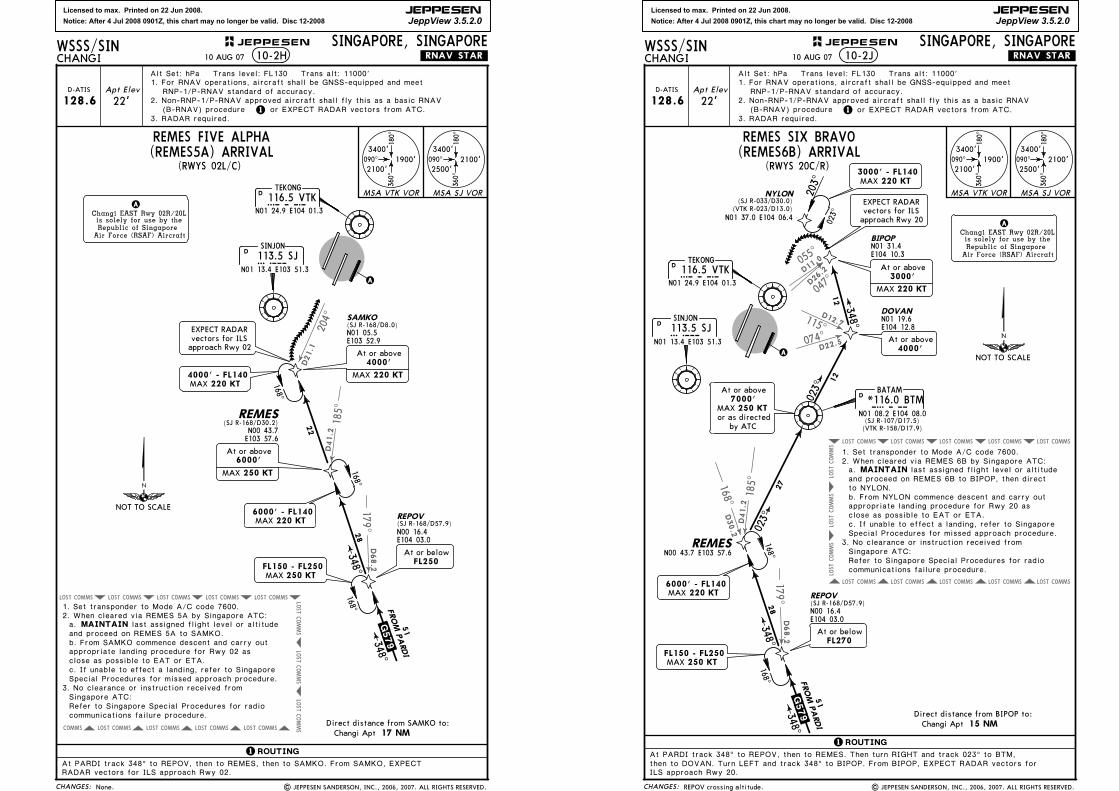
2. When cleared via REMES 5A by Singapore ATC:MAINTAIN
1. Set transponder to Mode A/C code 7600.
last assigned flight level or altitude
appropriate landing procedure for Rwy 02 as close as possible to EAT or ETA.
Special Procedures for missed approach procedure.
b. From SAMKO commence descent and carry out
a.
c. If unable to effect a landing, refer to Singapore
3. No clearance or instruction received from Singapore ATC:Refer to Singapore Special Procedures for radio communications failure procedure.
and proceed on REMES 5A to SAMKO.
6000' - FL140MAX 220 KT
168^168^
At or belowFL250
22
168^
(SJ R-168/D30.2)
4000' - FL140MAX 220 KT
EXPECT RADARvectors for ILSapproach Rwy 02
N01 05.5E103 52.9
(SJ R-168/D8.0)SAMKO
FL150 - FL250 250 KTMAX
N00 16.4E104 03.0
RADAR vectors for ILS approach Rwy 02.At PARDI track 348^ to REPOV, then to REMES, then to SAMKO. From SAMKO, EXPECT
1. For RNAV operations, aircraft shall be GNSS-equipped and meet RNP-1/P-RNAV standard of accuracy.
or EXPECT RADAR vectors from ATC.
REMES FIVE ALPHA(REMES5A) ARRIVAL
10 AUG 07
6000'
MAX 250 KT
At or above
At or above4000'
MAX 220 KT
| JEPPESEN SANDERSON, INC., 2006, 2007. ALL RIGHTS RESERVED.
2. Non-RNP-1/P-RNAV approved aircraft shall fly this as a basic RNAV(B-RNAV) procedure
None.
NOT TO SCALE
Licensed to max. Printed on 22 Jun 2008.
Notice: After 4 Jul 2008 0901Z, this chart may no longer be valid. Disc 12-2008
JEPPESEN
JeppView 3.5.2.0
COMMSLOST COMMSLOST COMMSLOST COMMSLOST COMMSLOST
COMMS
LOST
COMMS
LOST
COMMS
LOST
17 9^
185^168^
115^
074^
047^
055^
D26.2D1
1.0
D12.7
D22.5
D41.2
D30.2
D68.2
COMMSLOST COMMSLOST COMMSLOST COMMSLOST COMMSLOST
15 NM
CHANGES:
JEPPESENWSSS/SINCHANGI
SINGAPORE, SINGAPORE
TEKONG116.5 VTKVTK
N01 24.9 E104 01.3
D
A
Apt Elev
22'1
Changi EAST Rwy 02R/20Lis solely for use by theRepublic of Singapore
Air Force (RSAF) Aircraft
A
.RNAV.STAR.
Alt Set: hPa Trans level: FL130 Trans alt: 11000'
D-ATIS
128.6
3. RADAR required.
2. When cleared via REMES 6B by Singapore ATC:MAINTAIN
1 ROUTING
023^
203^
1. Set transponder to Mode A/C code 7600.
last assigned flight level or altitude
appropriate landing procedure for Rwy 20 as close as possible to EAT or ETA.
Special Procedures for missed approach procedure.
b. From NYLON commence descent and carry out
a.
c. If unable to effect a landing, refer to Singapore
3. No clearance or instruction received from Singapore ATC:Refer to Singapore Special Procedures for radio communications failure procedure.
Changi AptDirect distance from BIPOP to:
10-2J
090^
180^
360^
3400'
2500'2100'090^
180^
360^
3400'
2100'1900'
MSA VTK VOR MSA SJ VOR
(RWYS 20C/R)
SINJON
113.5 SJSJN01 13.4 E103 51.3
DFROM PARDI
.G579.348^
023^
348^
51
28
27
12
12
BATAM
*116.0 BTMBTMN01 08.2 E104 08.0
D
REPOV(SJ R-168/D57.9)
REMES
DOVANN01 19.6E104 12.8
N01 31.4E104 10.3
BIPOP
NYLON
N01 37.0 E104 06.4
(SJ R-033/D30.0)(VTK R-023/D13.0)
348^
and proceed on REMES 6B to BIPOP, then direct to NYLON.
3000' - FL140MAX 220 KT
6000' - FL140MAX 220 KT
168^168^
FL150 - FL250 250 KTMAX
023^
then to DOVAN. Turn LEFT and track 348^ to BIPOP. From BIPOP, EXPECT RADAR vectors for ILS approach Rwy 20.
EXPECT RADARvectors for ILSapproach Rwy 20
(SJ R-107/D17.5)(VTK R-158/D17.9)
N00 16.4E104 03.0
At PARDI track 348^ to REPOV, then to REMES. Then turn RIGHT and track 023^ to BTM,
1. For RNAV operations, aircraft shall be GNSS-equipped and meet RNP-1/P-RNAV standard of accuracy.
REMES SIX BRAVO(REMES6B) ARRIVAL
or EXPECT RADAR vectors from ATC.
10 AUG 07
At or belowFL270
N00 43.7 E103 57.6
At or above
MAX 250 KT7000'
or as directedby ATC
At or above4000'
At or above3000'
MAX 220 KT
| JEPPESEN SANDERSON, INC., 2006, 2007. ALL RIGHTS RESERVED.
2. Non-RNP-1/P-RNAV approved aircraft shall fly this as a basic RNAV(B-RNAV) procedure
REPOV crossing altitude.
NOT TO SCALE
Licensed to max. Printed on 22 Jun 2008.
Notice: After 4 Jul 2008 0901Z, this chart may no longer be valid. Disc 12-2008
JEPPESEN
JeppView 3.5.2.0
| JEPPESEN SANDERSON, INC., 1998, 2007. ALL RIGHTS RESERVED.
SINGAPORE, SINGAPORECHANGI
WSSS/SIN JEPPESEN+
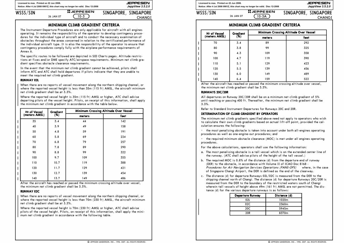
MINIMUM CLIMB GRADIENT CRITERIAMINIMUM CLIMB GRADIENT CRITERIAMINIMUM CLIMB GRADIENT CRITERIAMINIMUM CLIMB GRADIENT CRITERIAThe Instrument Departure Procedures are only applicable for aircraft with all enginesoperating. It remains the responsibility of the operator to develop contingency proce-dures for the individual type of aircraft and to conduct the necessary examination ofobstacles throughout the areas concerned in relation to the certificated performance ofthe individual aircraft type. It is also the responsibility of the operator to ensure thatcontingency procedures comply fully with the airplane performance requirements ofAnnex 6.
The specific routes to be followed are depicted in SID Charts pages. Altitude restric-tions at fixes and/or DME specify ATC/airspace requirements. Minimum net climb gra-dient specifies obstacle clearance requirements.
In the event that the minimum net climb gradient cannot be achieved, pilots shallinform ATC and ATC shall hold departures if pilots indicate that they are unable tomeet the required net climb gradient.
RUNWAY 02LRUNWAY 02LRUNWAY 02LRUNWAY 02L
When there are no reports of vessel movement along the northern shipping channel, orwhere the reported vessel height is less than 35m (115 ft) AMSL, the aircraft minimumnet climb gradient shall be at 3.3%.
Where the reported vessel height is 35m (115 ft) AMSL or higher, ATC shall advisedeparting pilots of the vessel height. Pilots, on receipt of this information, shall applythe minimum net climb gradient in accordance with the table below.
After the aircraft has reached or passed the minimum crossing altitude over vessel,the minimum net climb gradient shall be 3.3%.
RUNWAY 02CRUNWAY 02CRUNWAY 02CRUNWAY 02C
When there are no reports of vessel movement along the northern shipping channel, orwhere the reported vessel height is less than 70m (230 ft) AMSL, the aircraft minimumnet climb gradient shall be at 3.3%.
Where the reported vessel height is 70m (230 ft) AMSL or higher, ATC shall advisepilots of the vessel height. Pilots, on receipt of this information, shall apply the mini-mum net climb gradient in accordance with the following table.
Ht of VesselHt of VesselHt of VesselHt of Vessel(meters AMSL)(meters AMSL)(meters AMSL)(meters AMSL)
Gradient Gradient Gradient Gradient (%)(%)(%)(%)
Minimum Crossing Altitude Over VesselMinimum Crossing Altitude Over VesselMinimum Crossing Altitude Over VesselMinimum Crossing Altitude Over Vessel
metersmetersmetersmeters feetfeetfeetfeet
35 3.4 44 142
40 3.9 49 158
50 4.8 59 191
60 5.8 69 224
70 6.8 79 257
80 7.8 89 290
90 8.8 99 322
100 9.7 109 355
110 10.7 119 388
120 11.7 129 421
130 12.7 139 454
140 13.7 149 486
10-326 JAN 07
Licensed to max. Printed on 22 Jun 2008.
Notice: After 4 Jul 2008 0901Z, this chart may no longer be valid. Disc 12-2008
JEPPESEN
JeppView 3.5.2.0
| JEPPESEN SANDERSON, INC., 1998, 2007. ALL RIGHTS RESERVED.
SINGAPORE, SINGAPORECHANGI
WSSS/SIN JEPPESEN+
MINIMUM CLIMB GRADIENT CRITERIAMINIMUM CLIMB GRADIENT CRITERIAMINIMUM CLIMB GRADIENT CRITERIAMINIMUM CLIMB GRADIENT CRITERIA
After the aircraft has reached or passed the minimum crossing altitude over vessel,the minimum net climb gradient shall be 3.3%.
RUNWAYS 20C/20RRUNWAYS 20C/20RRUNWAYS 20C/20RRUNWAYS 20C/20R
All departures on Runway 20C/20R shall be on a minimum net climb gradient of 5%until reaching or passing 400 ft. Thereafter, the minimum net climb gradient shall be3.3%.
Refer to Standard Instrument Departures for Runways 20C and 20R.
DETERMINATION OF CLIMB GRADIENT BY OPERATORSDETERMINATION OF CLIMB GRADIENT BY OPERATORSDETERMINATION OF CLIMB GRADIENT BY OPERATORSDETERMINATION OF CLIMB GRADIENT BY OPERATORS
The minimum net climb gradients specified above need not apply to operators who wishto calculate their own climb gradients based on actual lift-off point, provided the cal-culation ensures the following:
^ the most penalizing obstacle is taken into account under both all-engines operatingprocedures as well as one-engine-out procedures; and
^ the required minimum obstacle clearance (MOC) is met under all engines operatingprocedures.
For the above calculations, operators shall use the following information:
a. The most penalizing obstacle is a tall vessel which is on the extended center line ofthe runway. (ATC shall advise pilots of the height of the tall vessel.)
b. The required MOC is 0.8% of the distance (d) from the departure end of runway(DER) to the obstacle, in accordance with Volume II of ICAO Doc 8168 - Procedures for Air Navigation Services Operations (PANS-OPS) where, in the caseof Singapore Changi Airport, the DER is defined as the end of the clearway.
c. The distance (d) for departure Runways 02L/02C is measured from the DER to theshipping channel north of Changi. The distance (d) for departure Runways 20C/20R ismeasured from the DER to the boundary of the restricted waters south of Changiwherein tall vessels of height above 49m (161 ft) AMSL are not permitted. The dis-tance (d) for the various departure runways is as follows:
Ht of VesselHt of VesselHt of VesselHt of Vessel(meters AMSL)(meters AMSL)(meters AMSL)(meters AMSL)
Gradient Gradient Gradient Gradient (%)(%)(%)(%)
Minimum Crossing Altitude Over VesselMinimum Crossing Altitude Over VesselMinimum Crossing Altitude Over VesselMinimum Crossing Altitude Over Vessel
metersmetersmetersmeters feetfeetfeetfeet
70 3.4 89 292
80 3.8 99 325
90 4.3 109 358
100 4.7 119 390
110 5.1 129 423
120 5.5 139 456
130 6.0 149 489
140 6.4 159 522
Departure RunwayDeparture RunwayDeparture RunwayDeparture Runway Distance (d)Distance (d)Distance (d)Distance (d)
02L 1020m02C 2360m
20C 5945m
20R 8370m
10-3A26 JAN 07
Licensed to max. Printed on 22 Jun 2008.
Notice: After 4 Jul 2008 0901Z, this chart may no longer be valid. Disc 12-2008
JEPPESEN
JeppView 3.5.2.0
083^
057^
059^
097^
195^
150^161^138^
D9.4
D23.2
D24.2
D39.0D34.1
D8.0
D6.9
D12.8
COMMSLOST COMMSLOST COMMSLOST LOSTCOMMS
LOST
COMMS
LOST
COMMS
LOST
LOST
COMMSLOST COMMSLOST COMMSLOST LOST
75 100 150 200 250 300
9 NM 4 NM
CHANGES:
JEPPESENWSSS/SINCHANGI
SINGAPORE, SINGAPORE
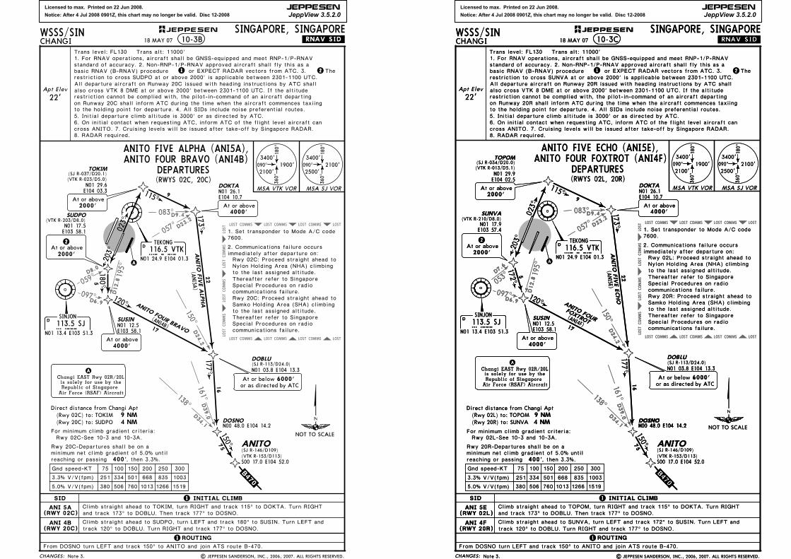
SID
SINJON
113.5 SJSJN01 13.4 E103 51.3
D
TEKONG116.5 VTKVTK
N01 24.9 E104 01.3
D
Trans level: FL130 Trans alt: 11000'
10-3B
Direct distance from Changi Apt
Gnd speed-KT
, then 3.3%. 400'
1519126610137605063805.0% V/V(fpm)
3.3% V/V(fpm) 251 334 501 668 835 1003
For minimum climb gradient criteria:
minimum net climb gradient of 5.0% untilreaching or passing
A
Apt Elev
22'
Climb straight ahead to SUDPO, turn LEFT and track 180^ to SUSIN. Turn LEFT and
Climb straight ahead to TOKIM, turn RIGHT and track 115^ to DOKTA. Turn RIGHT
115^
173^
120^
203^
180^
150^
9
22
16
75
17
5
N01 17.5E103 58.1
(VTK R-203/D8.0)SUDPO
N01 12.5E103 58.1
SUSIN
At or above4000'
N01 26.1E104 10.7
DOKTA
1 2
2At or above2000'
.RNAV.SID.
1 INITIAL CLIMB
1ROUTING
Changi EAST Rwy 02R/20Lis solely for use by theRepublic of Singapore
Air Force (RSAF) Aircraft
A
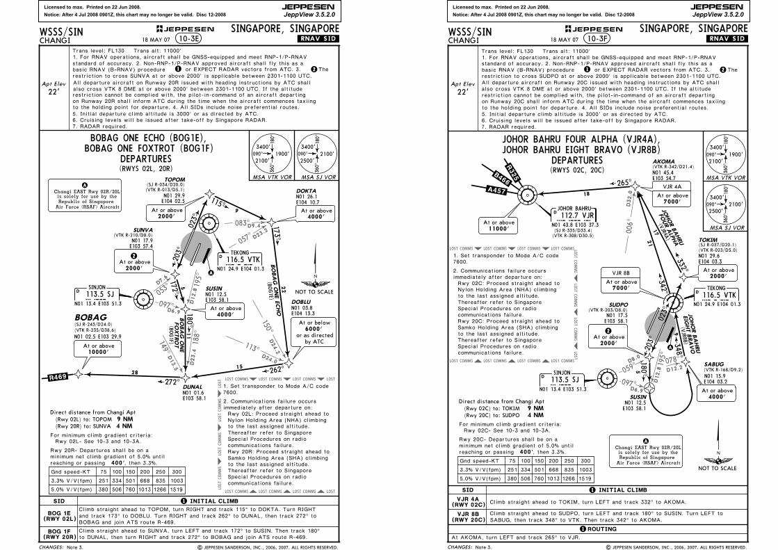
ANITO FIVE ALPHA (ANI5A),
ANI 5A(RWY 02C)
ANI 4B(RWY 20C)
DOSNO
ANITO
N00 48.0 E104 14.2
S00 17.0 E104 52.0
ANITO FIVE ALPHA
(ANI5A
)
(ANI4B)
ANITO FOUR BRAVO
(Rwy 02C) to: TOKIM(Rwy 20C) to: SUDPO
TOKIM(SJ R-037/D20.1)
N01 29.6E104 03.3
(VTK R-023/D5.0)
2000'At or above
(SJ R-113/D24.0)DOBLU
N01 03.8 E104 13.3
At or belowor as directed by ATC
6000'
Rwy 02C: Proceed straight ahead to Nylon Holding Area (NHA) climbing
Rwy 20C: Proceed straight ahead to Samko Holding Area (SHA) climbing
to the last assigned altitude.
to the last assigned altitude.
7600.1. Set transponder to Mode A/C code
2. Communications failure occurs immediately after departure on:
Thereafter refer to Singapore Special Procedures on radio communications failure.
Thereafter refer to Singapore Special Procedures on radio communications failure.
177^
.B470.
(VTK R-153/D113)(SJ R-146/D109)
and track 173^ to DOBLU. Then track 177^ to DOSNO.
track 120^ to DOBLU. Turn RIGHT and track 177^ to DOSNO.
From DOSNO turn LEFT and track 150^ to ANITO and join ATS route B-470.
090^
180^
360^
3400'
2500'2100'090^
180^
360^
3400'
2100'1900'
MSA VTK VOR MSA SJ VOR
(RWYS 02C, 20C)
ANITO FOUR BRAVO (ANI4B)
1. For RNAV operations, aircraft shall be GNSS-equipped and meet RNP-1/P-RNAV
Rwy 02C-See 10-3 and 10-3A.
DEPARTURES
18 MAY 07
or EXPECT RADAR vectors from ATC. 3.
| JEPPESEN SANDERSON, INC., 2006, 2007. ALL RIGHTS RESERVED.Note 3.
standard of accuracy. 2. Non-RNP-1/P-RNAV approved aircraft shall fly this as a basic RNAV (B-RNAV) procedure The restriction to cross SUDPO at or above 2000' is applicable between 2301-1100 UTC.
6. On initial contact when requesting ATC, inform ATC of the flight level aircraft can
8. RADAR required.cross ANITO. 7. Cruising levels will be issued after take-off by Singapore RADAR.
4000'At or above
All departure aircraft on Runway 20C issued with heading instructions by ATC shallalso cross VTK 8 DME at or above 2000' between 2301-1100 UTC. If the altitude restriction cannot be complied with, the pilot-in-command of an aircraft departingon Runway 20C shall inform ATC during the time when the aircraft commences taxiingto the holding point for departure. 4. All SIDs include noise preferential routes.5. Initial departure climb altitude is 3000' or as directed by ATC.
Rwy 20C-Departures shall be on a
023^
NOT TO SCALE
Licensed to max. Printed on 22 Jun 2008.
Notice: After 4 Jul 2008 0901Z, this chart may no longer be valid. Disc 12-2008
JEPPESEN
JeppView 3.5.2.0
083^
057^
053^
097^
195^
150^161^138^
D9.4
D23.2
D24.2
D39.0D34.1
D7.6
D6.9
D12.8
COMMSLOST COMMSLOST COMMSLOST LOST
COMMSLOST COMMSLOST COMMSLOST LOST
COMMS
LOST
COMMS
LOST
COMMS
LOST
LOST
083^
057^
053^
097^
195^
150^161^138^
D9.4
D23.2
D24.2
D39.0D34.1
D7.6
D6.9
D12.8
COMMSLOST COMMSLOST COMMSLOST LOST
COMMSLOST COMMSLOST COMMSLOST LOST
COMMS
LOST
COMMS
LOST
COMMS
LOST
LOST
75 100 150 200 250 300
CHANGES:
JEPPESENWSSS/SINCHANGI
SINGAPORE, SINGAPORE
SID
SINJON
113.5 SJSJN01 13.4 E103 51.3
D
TEKONG
116.5 VTKVTKN01 24.9 E104 01.3
D
10-3C
Gnd speed-KT
, then 3.3%. 400'
1519126610137605063805.0% V/V(fpm)
3.3% V/V(fpm) 251 334 501 668 835 1003
For minimum climb gradient criteria:
minimum net climb gradient of 5.0% untilreaching or passing
A
Apt Elev
22'
Climb straight ahead to SUNVA, turn LEFT and track 172^ to SUSIN. Turn LEFT and
Climb straight ahead to TOPOM, turn RIGHT and track 115^ to DOKTA. Turn RIGHT
115^
173^
120^
203^
172^
177^
9
22
16
17
5
N01 29.9E104 02.5
(VTK R-013/D5.1)
TOPOM
N01 17.9E103 57.4
(VTK R-210/D8.0)SUNVA
N01 12.5E103 58.1
SUSIN
At or above4000'
N01 26.1E104 10.7
DOKTA
(SJ R-113/D24.0)DOBLU
.RNAV.SID.
1 INITIAL CLIMB
1ROUTING
Rwy 02L: Proceed straight ahead to Nylon Holding Area (NHA) climbing
Rwy 20R: Proceed straight ahead to Samko Holding Area (SHA) climbing
Changi EAST Rwy 02R/20Lis solely for use by theRepublic of Singapore
Air Force (RSAF) Aircraft
A
ANI 5E(RWY 02L)
ANI 4F(RWY 20R)
DOSNON00 48.0 E104 14.2
to the last assigned altitude.
ANITO FIVE ECHO
(ANI5E)
(ANI4F)
ANITO FIVE ECHO (ANI5E),
9 NM 4 NM
Direct distance from Changi Apt(Rwy 02L) to: TOPOM(Rwy 20R) to: SUNVA
2At or above2000'
(SJ R-034/D20.0)
DOSNON00 48.0 E104 14.2
75
.B470.
150^
(RWYS 02L, 20R)
ANITO FOUR FOXTROT (ANI4F)
2000'At or above
4000'At or above
to the last assigned altitude.
7600.1. Set transponder to Mode A/C code
2. Communications failure occurs immediately after departure on:
Thereafter refer to Singapore Special Procedures on radio communications failure.
Thereafter refer to Singapore Special Procedures on radio communications failure.
N01 03.8 E104 13.3
At or belowor as directed by ATC
6000'
and track 173^ to DOBLU. Then track 177^ to DOSNO.
track 120^ to DOBLU. Turn RIGHT and track 177^ to DOSNO.
From DOSNO turn LEFT and track 150^ to ANITO and join ATS route B-470.
ANITO FOUR
FOXTROT
090^
180^
360^
3400'
2500'2100'090^
180^
360^
3400'
2100'1900'
MSA VTK VOR MSA SJ VOR
Trans level: FL130 Trans alt: 11000'
ANITO(SJ R-146/D109)
S00 17.0 E104 52.0(VTK R-153/D113)
Rwy 02L-See 10-3 and 10-3A.
DEPARTURES
18 MAY 07
standard of accuracy. 2. Non-RNP-1/P-RNAV approved aircraft shall fly this as a 1. For RNAV operations, aircraft shall be GNSS-equipped and meet RNP-1/P-RNAV
or EXPECT RADAR vectors from ATC. 3. restriction to cross SUNVA at or above 2000' is applicable between 2301-1100 UTC.
cross ANITO. 7. Cruising levels will be issued after take-off by Singapore RADAR.
The 21basic RNAV (B-RNAV) procedure
8. RADAR required.
6. On initial contact when requesting ATC, inform ATC of the flight level aircraft can
Note 3. | JEPPESEN SANDERSON, INC., 2006, 2007. ALL RIGHTS RESERVED.
also cross VTK 8 DME at or above 2000' between 2301-1100 UTC. If the altitude
on Runway 20R shall inform ATC during the time when the aircraft commences taxiing
5. Initial departure climb altitude is 3000' or as directed by ATC. to the holding point for departure. 4. All SIDs include noise preferential routes.
All departure aircraft on Runway 20R issued with heading instructions by ATC shall
restriction cannot be complied with, the pilot-in-command of an aircraft departing
Rwy 20R-Departures shall be on a
023^
023^
NOT TO SCALENOT TO SCALE
Licensed to max. Printed on 22 Jun 2008.
Notice: After 4 Jul 2008 0901Z, this chart may no longer be valid. Disc 12-2008
JEPPESEN
JeppView 3.5.2.0
083^
057^
059^
097^
195^
150^
D9.4
D23.2
D24.2
D8.0
D6.9
D12.8
113^
188^
D24.0
D23.4D
13.5
149^
COMMSLOST COMMSLOST COMMSLOST LOST
COMMSLOST COMMSLOST COMMSLOST LOST
COMMS
LOST
COMMS
LOST
COMMS
LOST
LOST
75 100 150 200 250 300
090^
180^
360^
3400'
2500'2100'
CHANGES:
JEPPESENWSSS/SINCHANGI
SINGAPORE, SINGAPORE
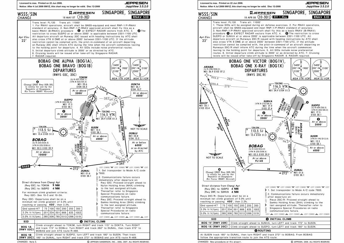
SID
SINJON113.5 SJSJ
N01 13.4 E103 51.3
D
TEKONG116.5 VTKVTK
N01 24.9 E104 01.3
D
10-3D
Gnd speed-KT
1519126610137605063805.0% V/V(fpm)
3.3% V/V(fpm) 251 334 501 668 835 1003
A
Apt Elev
22'
Climb straight ahead to TOKIM, turn RIGHT and track 115^ to DOKTA. Turn RIGHT
115^
173^
203^
180^
9
225
N01 17.5E103 58.1
(VTK R-203/D8.0)SUDPO
N01 12.5E103 58.1
SUSIN
N01 26.1E104 10.7
DOKTA
N01 03.8E104 13.3
DOBLU
2At or above2000'
.RNAV.SID.
1 INITIAL CLIMB
4000'At or above
Changi EAST Rwy 02R/20Lis solely for use by theRepublic of Singapore
Air Force (RSAF) Aircraft
A
BOG 1A(RWY 02C)
BOG 1B(RWY 20C)
BOBAG ONE ALPHA
(BOG1A
)
TOKIM(SJ R-037/D20.1)
N01 29.6E104 03.3
(VTK R-023/D5.0)
BOBAG ONE ALPHA (BOG1A),
Climb straight ahead to SUDPO, turn LEFT and track 180^ to SUSIN. Then track
At or above4000'
N01 01.6E103 58.1
DUNAL
11
BOBAG ONE
(BOG1B)
BRAVO
262^
272^.R469.15
28
BOBAG(SJ R-243/D24.0)
N01 02.5 E103 29.9(VTK R-235/D38.6)
9 NM 4 NM
Direct distance from Changi Apt
, then 3.3%. 400'
For minimum climb gradient criteria:
minimum net climb gradient of 5.0% untilreaching or passing
Rwy 20C- Departures shall be on a
(Rwy 02C) to: TOKIM(Rwy 20C) to: SUDPO
Rwy 02C: Proceed straight ahead to Nylon Holding Area (NHA) climbing
Rwy 20C: Proceed straight ahead to Samko Holding Area (SHA) climbing
to the last assigned altitude.
to the last assigned altitude.
7600.1. Set transponder to Mode A/C code
2. Communications failure occurs immediately after departure on:
Thereafter refer to Singapore Special Procedures on radio communications failure.
Thereafter refer to Singapore Special Procedures on radio communications failure.
At or below6000'
or as directedby ATC
10000'At or above
Rwy 02C- See 10-3 and 10-3A.
180^ to DUNAL, turn RIGHT and track 272^ to BOBAG and join ATS route R-469.
and track 173^ to DOBLU. Turn RIGHT and track 262^ to DUNAL, then track 272^ to BOBAG and join ATS route R-469.
(RWYS 02C, 20C)
BOBAG ONE BRAVO (BOG1B)090^
180^
360^
3400'
2100'1900'
MSA VTK VOR MSA SJ VOR
Trans level: FL130 Trans alt: 11000'1. For RNAV operations, aircraft shall be GNSS-equipped and meet RNP-1/P-RNAV
DEPARTURES
standard of accuracy. 2. Non-RNP-1/P-RNAV approved aircraft shall fly this as a
18 MAY 07
Note 3. | JEPPESEN SANDERSON, INC., 2006, 2007. ALL RIGHTS RESERVED.
1basic RNAV (B-RNAV) procedurerestriction to cross SUDPO at or above 2000' is applicable between 2301-1100 UTC.
7. RADAR required.6. Cruising levels will be issued after take-off by Singapore RADAR.
or EXPECT RADAR vectors from ATC. 3. The2
2000'At or above
All departure aircraft on Runway 20C issued with heading instructions by ATC shallalso cross VTK 8 DME at or above 2000' between 2301-1100 UTC. If the altitude restriction cannot be complied with, the pilot-in-command of an aircraft departingon Runway 20C shall inform ATC during the time when the aircraft commences taxiing
5. Initial departure climb altitude is 3000' or as directed by ATC. to the holding point for departure. 4. All SIDs include noise preferential routes.
023^
NOT TO SCALE
Licensed to max. Printed on 22 Jun 2008.
Notice: After 4 Jul 2008 0901Z, this chart may no longer be valid. Disc 12-2008
JEPPESEN
JeppView 3.5.2.0
097D6.9
188^
D23.4
D13.5
149^
D7.6
053^
COMMSLOST COMMSLOST COMMSLOST COMMSLOSTLOST
COMMS
COMMS
LOST
COMMSLOST COMMSLOST COMMSLOST COMMSLOST LOST
282^
278^
293^
D55.5
D56.6
D50.0
CHANGES:
JEPPESENWSSS/SINCHANGI
SINGAPORE, SINGAPORE
SID
10-3D1
A
Apt Elev
22'
203^
180^5
N01 17.5E103 58.1
(VTK R-203/D8.0)
SUDPO
N01 12.5E103 58.1
SUSIN
.RNAV.SID.
Changi EAST Rwy 02R/20Lis solely for use by theRepublic of Singapore
Air Force (RSAF) Aircraft
AN01 01.6E103 58.1
DUNAL
11
272^
28
BOBAG(SJ R-243/D24.0)
N01 02.5 E103 29.9(VTK R-235/D38.6)
FL140At or above
Trans level: FL130 Trans alt: 11000'
18 APR 08 .Eff.1.May.
| JEPPESEN, 2008. ALL RIGHTS RESERVED.
TEKONG116.5 VTKVTK
N01 24.9 E104 01.3
D
SUNVA(VTK R-210/D8.0)
N01 17.9E103 57.4
203^
172^5
(SJ R-059/D8.0)
(VTK R-195/D12.8)
(BOG1
V)
BOBAG ONE
VICTOR
(BOG1X
)
2At or above2000'
2At or above2000'
At or above4000'
Climb straight ahead to SUDPO, turn LEFT and track 180^ to SUSIN.
Climb straight ahead to SUNVA, turn LEFT and track 172^ to SUSIN.BOG 1V (RWY 20R)
BOG 1X (RWY 20C)
ROUTING
At SUSIN track 180^ to DUNAL, then turn RIGHT and track 272^ to BOBAG. From BOBAGfollow the appropriate transition route to join the ATS route.
090^
180^
360^
3400'
2500'2100'090^
180^
360^
3400'
2100'1900'
MSA VTK VOR MSA SJ VOR
321^327^
41
39
ARAMAREKOP
ARAMA
REKOPN01 33.1E103 05.4
SINJON113.5 SJSJ
N01 13.4 E103 51.3
D
New procedures at this airport.
4 NMDirect distance from Changi Apt(Rwy 20C) to: SUDPO
75 100 150 200 250 300Gnd speed-KT
1519126610137605063805.0% V/V(fpm)
3.3% V/V(fpm) 251 334 501 668 835 1003
, then 3.3%. 400'minimum net climb gradient of 5.0% untilreaching or passing
Rwys 20C/R- Departures shall be on a
1. Set transponder to Mode A/C code 7600.
2. Communications failure occurs immediatelyafter departure on:Rwys 20C/R: Proceed straight ahead toSamko Holding Area (SHA) climbing to thelast assigned altitude. Thereafter refer toSingapore Special Procedures on radiocommunications failure.
(SJ R-298/D50.0)N01 36.9 E103 07.2
(Rwy 20R) to: SUNVA 4 NM
1 INITIAL CLIMB
1
1 2
1. These SIDs will be assigned during air defense exercises. 2. For RNAV operations,
procedure or EXPECT RADAR vectors from ATC. 4. 3. Non-RNP-1/P-RNAV approved aircraft shall fly this as a basic RNAV (B-RNAV)
The restriction to cross SUDPO or SUNVA at or above 2000' is applicable between 2301-1100 UTC. Alldeparture aircraft on Runways 20C/R issued with heading instructions by ATC shall also cross VTK 8 DME at or above 2000' between 2301-1100 UTC. If the altituderestriction cannot be complied with, the pilot-in-command of an aircraft departing on Runways 20C/R shall inform ATC during the time when the aircraft commencestaxiing to the holding point for departure. 5. All SIDs include noise preferential
levels will be issued after take-off by Singapore RADAR. 8. RADAR required.routes. 6. Initial departure climb altitude is 3000' or as directed by ATC. 7. Cruising
DEPARTURES
BOBAG ONE VICTOR (BOG1V),
(RWYS 20C/R)
BOBAG ONE X-RAY (BOG1X)
BOBAG ONE
X-RAY
aircraft shall be GNSS-equipped and meet RNP-1/P-RNAV standard of accuracy.
180^
NOT TO SCALE
Licensed to max. Printed on 22 Jun 2008.
Notice: After 4 Jul 2008 0901Z, this chart may no longer be valid. Disc 12-2008
JEPPESEN
JeppView 3.5.2.0
083^
057^
097^
195^
150^
D9.4
D23.2
D24.2
D6.9
D12.8
113^
188^
D24.0D23.4D
13.5
149^
053^
D7.6
COMMSLOST COMMSLOST COMMSLOST LOST
COMMSLOST COMMSLOST COMMSLOST LOST
COMMS
LOST
COMMS
LOST
COMMS
LOST
LOST
75 100 150 200 250 300
CHANGES:
JEPPESENWSSS/SINCHANGI
SINGAPORE, SINGAPORE
SID
SINJON
113.5 SJSJN01 13.4 E103 51.3
D
TEKONG116.5 VTKVTK
N01 24.9 E104 01.3
D
10-3E
Gnd speed-KT
1519126610137605063805.0% V/V(fpm)
3.3% V/V(fpm) 251 334 501 668 835 1003
A
Apt Elev
22'
Climb straight ahead to TOPOM, turn RIGHT and track 115^ to DOKTA. Turn RIGHT 173^
22
N01 12.5E103 58.1
SUSIN
N01 26.1E104 10.7
DOKTA
.RNAV.SID.
1 INITIAL CLIMB
4000'At or above
Changi EAST Rwy 02R/20Lis solely for use by theRepublic of Singapore
Air Force (RSAF) Aircraft
A
BOG 1E(RWY 02L)
BOG 1F(RWY 20R)
(BOG1E)
BOBAG ONE ECHO (BOG1E),
At or above4000'
11
BOBAG ONE
(BOG1F)
262^
272^.R469.15
28
BOBAG(SJ R-243/D24.0)
N01 02.5 E103 29.9(VTK R-235/D38.6)
TOPOM
(VTK R-013/D5.1)(SJ R-034/D20.0)
N01 29.9E104 02.5
SUNVA(VTK R-210/D8.0)
N01 17.9E103 57.4
203^
172^5
115^9
BOBAG ONE ECHO
FOXTROT
N01 01.6E103 58.1
DUNAL
Rwy 02L: Proceed straight ahead to Nylon Holding Area (NHA) climbing
Rwy 20R: Proceed straight ahead to Samko Holding Area (SHA) climbing
to the last assigned altitude.
to the last assigned altitude.
7600.1. Set transponder to Mode A/C code
2. Communications failure occurs immediately after departure on:
Thereafter refer to Singapore Special Procedures on radio communications failure.
Thereafter refer to Singapore Special Procedures on radio communications failure.
At or below6000'
or as directedby ATC
N01 03.8E104 13.3
DOBLU
, then 3.3%. 400'
For minimum climb gradient criteria:
minimum net climb gradient of 5.0% untilreaching or passing
Rwy 20R- Departures shall be on a
9 NM 4 NM
Direct distance from Changi Apt(Rwy 02L) to: TOPOM(Rwy 20R) to: SUNVA
BOBAG ONE FOXTROT (BOG1F)
(RWYS 02L, 20R)
180^
At or above10000'
Rwy 02L- See 10-3 and 10-3A.
to DUNAL, then turn RIGHT and track 272^ to BOBAG and join ATS route R-469.Climb straight ahead to SUNVA, turn LEFT and track 172^ to SUSIN. Then track 180^
and track 173^ to DOBLU. Turn RIGHT and track 262^ to DUNAL, then track 272^ to BOBAG and join ATS route R-469.
090^
180^
360^
3400'
2500'2100'090^
180^
360^
3400'
2100'1900'
MSA VTK VOR MSA SJ VOR
DEPARTURES
Trans level: FL130 Trans alt: 11000'1. For RNAV operations, aircraft shall be GNSS-equipped and meet RNP-1/P-RNAV standard of accuracy. 2. Non-RNP-1/P-RNAV approved aircraft shall fly this as a
restriction to cross SUNVA at or above 2000' is applicable between 2301-1100 UTC. basic RNAV (B-RNAV) procedure 1 or EXPECT RADAR vectors from ATC. 3. 2The
6. Cruising levels will be issued after take-off by Singapore RADAR.7. RADAR required.
18 MAY 07
Note 3. | JEPPESEN SANDERSON, INC., 2006, 2007. ALL RIGHTS RESERVED.
2At or above2000'
2000'At or above
All departure aircraft on Runway 20R issued with heading instructions by ATC shall
restriction cannot be complied with, the pilot-in-command of an aircraft departingon Runway 20R shall inform ATC during the time when the aircraft commences taxiing
5. Initial departure climb altitude is 3000' or as directed by ATC. to the holding point for departure. 4. All SIDs include noise preferential routes.
also cross VTK 8 DME at or above 2000' between 2301-1100 UTC. If the altitude
023^
NOT TO SCALE
Licensed to max. Printed on 22 Jun 2008.
Notice: After 4 Jul 2008 0901Z, this chart may no longer be valid. Disc 12-2008
JEPPESEN
JeppView 3.5.2.0
059^
097^
195^
D8.0
D6.9
D12.8
078^
D12.2
D32.0
006^
COMMSLOST COMMSLOST COMMSLOST
COMMS
LOST
COMMS
LOST
COMMS
LOST
LOST
COMMSLOST COMMSLOST COMMSLOST
LOST COMMS
COMMSLOST
75 100 150 200 250 300
CHANGES:
JEPPESENWSSS/SINCHANGI
SINGAPORE, SINGAPORE
SID
SINJON
113.5 SJSJN01 13.4 E103 51.3
D
TEKONG
116.5 VTKVTKN01 24.9 E104 01.3
D
10-3F
Gnd speed-KT
1519126610137605063805.0% V/V(fpm)
3.3% V/V(fpm) 251 334 501 668 835 1003
A203^
180^5
N01 17.5E103 58.1
(VTK R-203/D8.0)SUDPO
N01 12.5E103 58.1
SUSIN
2At or above2000'
.RNAV.SID.
1 INITIAL CLIMB
1ROUTING
Changi EAST Rwy 02R/20Lis solely for use by theRepublic of Singapore
Air Force (RSAF) Aircraft
A
VJR 4A(RWY 02C)
VJR 8B(RWY 20C)
TOKIM(SJ R-037/D20.1)
N01 29.6E104 03.3
(VTK R-023/D5.0)
JOHOR BAHRU FOUR ALPHA (VJR4A),
Climb straight ahead to SUDPO, turn LEFT and track 180^ to SUSIN. Turn LEFT to
At AKOMA, turn LEFT and track 265^ to VJR.
Climb straight ahead to TOKIM, turn LEFT and track 332^ to AKOMA.
SABUG, then track 348^ to VTK. Then track 342^ to AKOMA.
348^
342^
332^
265^
9
21
17
18
(VJR8B)
(VJR4A
)
JOHOR BAHRU
JOHOR BAHRU
FOUR ALPHA
SABUG(VTK R-168/D9.2)
AKOMA
N01 45.4E103 54.7
(VTK R-342/D21.4)
.A457.
.B466.
.R325.
112.7 VJRVJRN01 43.8 E103 37.3
DJOHOR BAHRU
At or above11000'
9 NM 4 NM
Direct distance from Changi Apt
, then 3.3%. 400'
For minimum climb gradient criteria:
minimum net climb gradient of 5.0% untilreaching or passing
Rwy 20C- Departures shall be on a
(Rwy 02C) to: TOKIM(Rwy 20C) to: SUDPO
Rwy 02C: Proceed straight ahead to Nylon Holding Area (NHA) climbing
Rwy 20C: Proceed straight ahead to Samko Holding Area (SHA) climbing
to the last assigned altitude.
to the last assigned altitude.
7600.1. Set transponder to Mode A/C code
2. Communications failure occurs immediately after departure on:
Thereafter refer to Singapore Special Procedures on radio communications failure.
Thereafter refer to Singapore Special Procedures on radio communications failure.
(RWYS 02C, 20C)
JOHOR BAHRU EIGHT BRAVO (VJR8B)
7000'At or above
VJR 8B
EIGHT BRAVO
Rwy 02C- See 10-3 and 10-3A.
090^
180^
360^
3400'
2500'2100'
090^
180^
360^
3400'
2100'1900'
MSA VTK VOR
MSA SJ VOR(SJ R-335/D33.4)(VTK R-308/D30.5)
DEPARTURES
N01 15.9E104 03.2
At or above4000'
Apt Elev
22'
Trans level: FL130 Trans alt: 11000'1. For RNAV operations, aircraft shall be GNSS-equipped and meet RNP-1/P-RNAV
basic RNAV (B-RNAV) procedurerestriction to cross SUDPO at or above 2000' is applicable between 2301-1100 UTC.
or EXPECT RADAR vectors from ATC. 3. standard of accuracy. 2. Non-RNP-1/P-RNAV approved aircraft shall fly this as a
2The1
6. Cruising levels will be issued after take-off by Singapore RADAR.7. RADAR required.
2000'At or above
Note 3. | JEPPESEN SANDERSON, INC., 2006, 2007. ALL RIGHTS RESERVED.
18 MAY 07
7000'At or above
VJR 4A
All departure aircraft on Runway 20C issued with heading instructions by ATC shallalso cross VTK 8 DME at or above 2000' between 2301-1100 UTC. If the altituderestriction cannot be complied with, the pilot-in-command of an aircraft departingon Runway 20C shall inform ATC during the time when the aircraft commences taxiing
5. Initial departure climb altitude is 3000' or as directed by ATC. to the holding point for departure. 4. All SIDs include noise preferential routes.
023^
NOT TO SCALE

Licensed to max. Printed on 22 Jun 2008.
Notice: After 4 Jul 2008 0901Z, this chart may no longer be valid. Disc 12-2008
JEPPESEN
JeppView 3.5.2.0
097^
195^
D6.9
D12.8
078^
D12.2
D32.0
006^
053^
D7.6
COMMSLOST COMMSLOST COMMSLOST
COMMS
LOST
COMMS
LOST
COMMS
LOST
LOST
COMMSLOST COMMSLOST COMMSLOST
LOST COMMS
LOST COMMS
75 100 150 200 250 300
9 NM 4 NM
CHANGES:
JEPPESENWSSS/SINCHANGI
SINGAPORE, SINGAPORE
SID
SINJON
113.5 SJSJN01 13.4 E103 51.3
D
TEKONG
116.5 VTKVTKN01 24.9 E104 01.3
D
10-3G
Direct distance from Changi Apt
Gnd speed-KT
, then 3.3%. 400'
1519126610137605063805.0% V/V(fpm)
3.3% V/V(fpm) 251 334 501 668 835 1003
For minimum climb gradient criteria:
minimum net climb gradient of 5.0% untilreaching or passing
A
Rwy 20R- Departures shall be on a
.RNAV.SID.
1 INITIAL CLIMB
1ROUTING
Changi EAST Rwy 02R/20Lis solely for use by theRepublic of Singapore
Air Force (RSAF) Aircraft
A
VJR 4E(RWY 02L)
VJR 8F(RWY 20R)
(Rwy 02L) to: TOPOM(Rwy 20R) to: SUNVA
Climb straight ahead to SUNVA, turn LEFT and track 172^ to SUSIN. Turn LEFT to
At AKOMA, turn LEFT and track 265^ to VJR.
Climb straight ahead to TOPOM, turn LEFT and track 333^ to AKOMA.
SABUG, then track 348^ to VTK. Then track 342^ to AKOMA.
348^
342^333^
265^
9
21
17
18
(VJR8F)
(VJR4E)
JOHOR BAHRU
JOHOR BAHRU
FOUR ECHO
AKOMA
N01 45.4E103 54.7
(VTK R-342/D21.4)
.A457.
.B466.
.R325.
112.7 VJRVJRN01 43.8 E103 37.3
DJOHOR BAHRU
At or above11000'
JOHOR BAHRU FOUR ECHO (VJR4E),
N01 29.9E104 02.5
(VTK R-013/D5.1)(SJ R-034/D20.0)TOPOM
203^2
At or above2000'
N01 17.9E103 57.4
(VTK R-210/D8.0)SUNVA
172^5
7000'At or above
VJR 4E
Rwy 02L: Proceed straight ahead to Nylon Holding Area (NHA) climbing
Rwy 20R: Proceed straight ahead to Samko Holding Area (SHA) climbing
to the last assigned altitude.
to the last assigned altitude.
7600.1. Set transponder to Mode A/C code
2. Communications failure occurs immediately after departure on:
Thereafter refer to Singapore Special Procedures on radio communications failure.
Thereafter refer to Singapore Special Procedures on radio communications failure.
(RWYS 02L, 20R)
JOHOR BAHRU EIGHT FOXTROT (VJR8F)
EIGHT FOXTROT
Rwy 02L- See 10-3 and 10-3A.
090^
180^
360^
3400'
2500'2100'
090^
180^
360^
3400'
2100'1900'
MSA VTK VOR
MSA SJ VOR
At or above7000'
(SJ R-335/D33.4)(VTK R-308/D30.5)
DEPARTURES
SABUG(VTK R-168/D9.2)N01 15.9E104 03.2
At or above4000'
N01 12.5E103 58.1
SUSIN
Apt Elev
22'
Trans level: FL130 Trans alt: 11000'1. For RNAV operations, aircraft shall be GNSS-equipped and meet RNP-1/P-RNAV standard of accuracy. 2. Non-RNP-1/P-RNAV approved aircraft shall fly this as a
restriction to cross SUNVA at or above 2000' is applicable between 2301-1100 UTC. basic RNAV (B-RNAV) procedure 1 or EXPECT RADAR vectors from ATC. 3. 2The
6. Cruising levels will be issued after take-off by Singapore RADAR.7. RADAR required.
18 MAY 07
Note 3. | JEPPESEN SANDERSON, INC., 2006, 2007. ALL RIGHTS RESERVED.
2000'At or above
All departure aircraft on Runway 20R issued with heading instructions by ATC shallalso cross VTK 8 DME at or above 2000' between 2301-1100 UTC. If the altituderestriction cannot be complied with, the pilot-in-command of an aircraft departingon Runway 20R shall inform ATC during the time when the aircraft commences taxiing
5. Initial departure climb altitude is 3000' or as directed by ATC. to the holding point for departure. 4. All SIDs include noise preferential routes.
023^
NOT TO SCALE
Licensed to max. Printed on 22 Jun 2008.
Notice: After 4 Jul 2008 0901Z, this chart may no longer be valid. Disc 12-2008
JEPPESEN
JeppView 3.5.2.0
343^
023^
285^
332^
274^
033^
025^
298^
D36.6
D30.0
D19.3D18.6
D6.6
D19.6
D13.0D30.0
001^
TEKONG116.5 VTKVTK
N01 24.9 E104 01.3
D
Changi EAST Rwy 02R/20Lis solely for use by theRepublic of Singapore
Air Force (RSAF) Aircraft
A
A
KONG KONG
286 KKKKN01 31.3 E103 59.4
JAYBEE
400 JBJBN01 30.0 E103 42.7
LELIBN01 27.5E103 24.8
NYLONN01 37.0E104 06.4
to LELIB
MAINTAINFL140
At FL140
Passing10000'
090^
180^
360^
3400'
2100'
1900'
MSA VTK VOR
Apt Elev
22'
JEPPESENWSSS/SINCHANGI
SINGAPORE, SINGAPORE
Trans level: FL130 Trans alt: 11000'
10-3H .SID.
2. All SIDs include noise preferential routes.
4. Cruising levels will be issued after take-off by SingaporeRADAR.
(RWYS 02L/C)
3. Initial departure climb altitude is 3000' or as directed by ATC.
.Eff.1.May.
CHANGES:
ROUTING
18 APR 08
LELIB ONE CHARLIE (LLB1C) DEPARTURE
10000',
4 NM
For minimum climb gradient criteria:
RWY
02L Climb straight ahead.
INITIAL CLIMB
02C Climb straight ahead to VTK.
Intercept and proceed on VTK R-001. After passing
Rwys 02L/C- See 10-3 and 10-3A.
MAINTAIN FL140
Direct distance from Changi Apt to:
turn RIGHT to NYLON. At NYLON,turn RIGHT and proceed direct to KK. Track 266^ bearing from KK to JB. Track 262^ bearingfrom JB to LELIB and join airway A-464. from NYLON to LELIB.
1. This SID will be assigned during air defense exercises.
LELIB ONE DELTA SID cancelled. | JEPPESEN, 2004, 2008. ALL RIGHTS RESERVED.
SINJON
113.5 SJSJN01 13.4 E103 51.3
D
(Rwy 02L/C) to: VTK
266^
262^17
18FL140
FL140
NOT TO SCALE
.A.464.
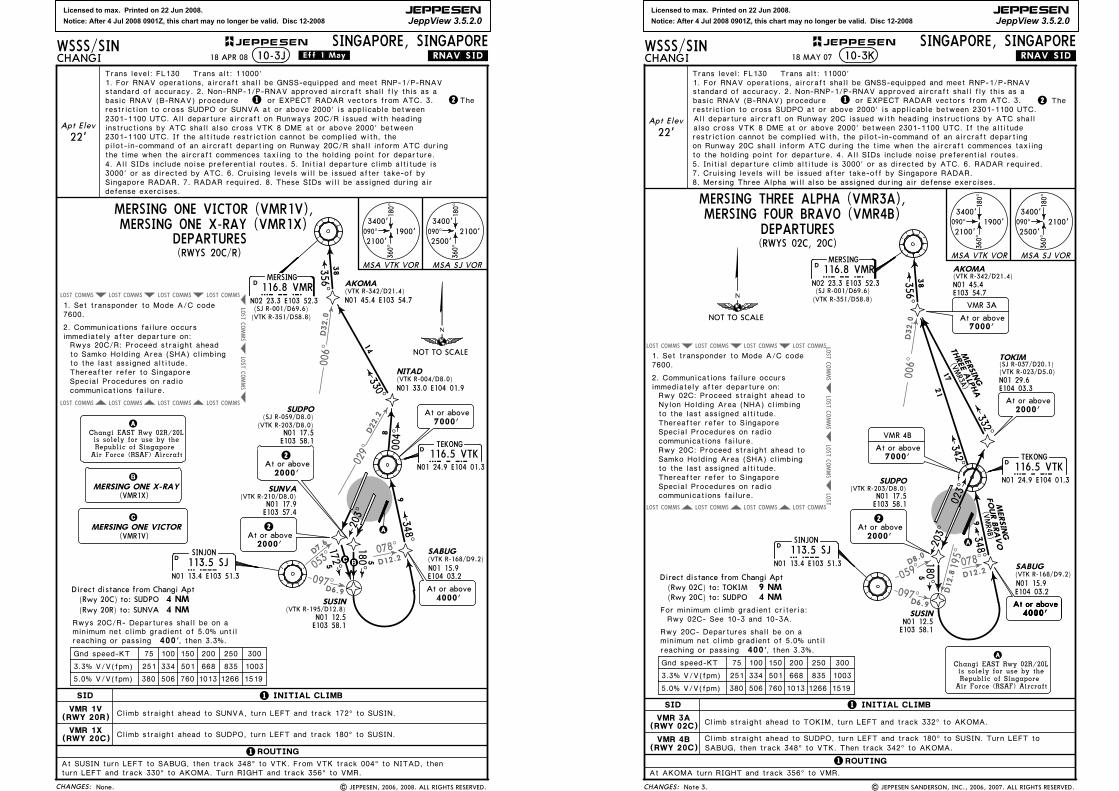
Licensed to max. Printed on 22 Jun 2008.
Notice: After 4 Jul 2008 0901Z, this chart may no longer be valid. Disc 12-2008
JEPPESEN
JeppView 3.5.2.0
097D6.9
078^
D12.2
D32.0
006^
053^
D7.6
029^
D22.2
COMMSLOST COMMSLOST COMMSLOST COMMSLOST
COMMS
LOST
COMMS
LOST
COMMSLOST COMMSLOST COMMSLOST COMMSLOST
75 100 150 200 250 300
4 NM
CHANGES:
JEPPESENWSSS/SINCHANGI
SINGAPORE, SINGAPORE
SID
SINJON
113.5 SJSJN01 13.4 E103 51.3
D
TEKONG116.5 VTKVTK
N01 24.9 E104 01.3
D
10-3J
Direct distance from Changi Apt
Gnd speed-KT
, then 3.3%. 400'
1519126610137605063805.0% V/V(fpm)
3.3% V/V(fpm) 251 334 501 668 835 1003
minimum net climb gradient of 5.0% untilreaching or passing
A
203^
180^ 5
N01 17.5E103 58.1
(SJ R-059/D8.0)SUDPO
N01 12.5E103 58.1
SUSIN
.RNAV.SID.
1 INITIAL CLIMB
1ROUTING
Changi EAST Rwy 02R/20Lis solely for use by theRepublic of Singapore
Air Force (RSAF) Aircraft
A
VMR 1X(RWY 20C)
VMR 1V(RWY 20R)
Climb straight ahead to SUDPO, turn LEFT and track 180^ to SUSIN.
348^9
AKOMA(VTK R-342/D21.4)
MERSING ONE X-RAY (VMR1X)
Rwys 20C/R- Departures shall be on a
Climb straight ahead to SUNVA, turn LEFT and track 172^ to SUSIN.
At SUSIN turn LEFT to SABUG, then track 348^ to VTK. From VTK track 004^ to NITAD, then turn LEFT and track 330^ to AKOMA. Turn RIGHT and track 356^ to VMR.
N01 17.9E103 57.4
(VTK R-210/D8.0)SUNVA
172^5
2At or above2000'
2At or above2000'
(VTK R-203/D8.0)
(VTK R-195/D12.8)
7000'At or above
NITAD(VTK R-004/D8.0)N01 33.0 E104 01.9
N01 45.4 E103 54.7
004^
330^
356^
8
14
38
MERSING
116.8 VMRVMRN02 23.3 E103 52.3
D
090^
180^
360^
3400'
2500'2100'090^
180^
360^
3400'
2100'1900'
MSA VTK VOR MSA SJ VOR
to the last assigned altitude.
7600.1. Set transponder to Mode A/C code
2. Communications failure occurs immediately after departure on:
Thereafter refer to Singapore Special Procedures on radio communications failure.
Rwys 20C/R: Proceed straight ahead to Samko Holding Area (SHA) climbing
(Rwy 20C) to: SUDPO(Rwy 20R) to: SUNVA 4 NM
CB
(VTK R-351/D58.8)(SJ R-001/D69.6)
DEPARTURES
SABUG(VTK R-168/D9.2)N01 15.9E104 03.2
At or above4000'
Apt Elev
22'
Trans level: FL130 Trans alt: 11000'
1 2
1. For RNAV operations, aircraft shall be GNSS-equipped and meet RNP-1/P-RNAV
or EXPECT RADAR vectors from ATC. 3. standard of accuracy. 2. Non-RNP-1/P-RNAV approved aircraft shall fly this as a basic RNAV (B-RNAV) procedure The restriction to cross SUDPO or SUNVA at or above 2000' is applicable between
2301-1100 UTC. If the altitude restriction cannot be complied with, the pilot-in-command of an aircraft departing on Runway 20C/R shall inform ATC during the time when the aircraft commences taxiing to the holding point for departure. 4. All SIDs include noise preferential routes. 5. Initial departure climb altitude is
Singapore RADAR. 7. RADAR required. 8. These SIDs will be assigned during airdefense exercises.
3000' or as directed by ATC. 6. Cruising levels will be issued after take-of by
2301-1100 UTC. All departure aircraft on Runways 20C/R issued with headinginstructions by ATC shall also cross VTK 8 DME at or above 2000' between
B
(VMR1X)
C
(VMR1V)MERSING ONE VICTOR
MERSING ONE X-RAY
MERSING ONE VICTOR (VMR1V),
18 APR 08 .Eff.1.May.
None. | JEPPESEN, 2006, 2008. ALL RIGHTS RESERVED.
(RWYS 20C/R)
NOT TO SCALE
Licensed to max. Printed on 22 Jun 2008.
Notice: After 4 Jul 2008 0901Z, this chart may no longer be valid. Disc 12-2008
JEPPESEN
JeppView 3.5.2.0
059^
097^
195^
D8.0
D6.9
D12.8
078^
D12.2
D32.0
006^
COMMSLOST COMMSLOST COMMSLOST
COMMS
LOST
COMMS
LOST
COMMS
LOST
LOST
COMMSLOST COMMSLOST COMMSLOST
LOST COMMS
COMMSLOST
75 100 150 200 250 300
9 NM 4 NM
CHANGES:
JEPPESENWSSS/SINCHANGI
SINGAPORE, SINGAPORE
SID
SINJON
113.5 SJSJN01 13.4 E103 51.3
D
TEKONG
116.5 VTKVTKN01 24.9 E104 01.3
D
10-3K
Direct distance from Changi Apt
Gnd speed-KT
, then 3.3%. 400'
1519126610137605063805.0% V/V(fpm)
3.3% V/V(fpm) 251 334 501 668 835 1003
For minimum climb gradient criteria:
minimum net climb gradient of 5.0% untilreaching or passing
A
Apt Elev
22'
203^
180^5
N01 17.5E103 58.1
(VTK R-203/D8.0)SUDPO
2At or above2000'
Rwy 20C- Departures shall be on a
.RNAV.SID.
1 INITIAL CLIMB
1ROUTING
Changi EAST Rwy 02R/20Lis solely for use by theRepublic of Singapore
Air Force (RSAF) Aircraft
A
VMR 3A(RWY 02C)
VMR 4B(RWY 20C)
(Rwy 02C) to: TOKIM(Rwy 20C) to: SUDPO
TOKIM(SJ R-037/D20.1)
N01 29.6E104 03.3
(VTK R-023/D5.0)
Climb straight ahead to SUDPO, turn LEFT and track 180^ to SUSIN. Turn LEFT to
At AKOMA turn RIGHT and track 356^ to VMR.
Climb straight ahead to TOKIM, turn LEFT and track 332^ to AKOMA.
SABUG, then track 348^ to VTK. Then track 342^ to AKOMA.
348^
342^
332^9
21
17
(VMR4B)
(VMR3A
)
FOUR BRAVO
2000'At or above
AKOMA
N01 45.4E103 54.7
(VTK R-342/D21.4)
MERSING THREE ALPHA (VMR3A),MERSING FOUR BRAVO (VMR4B)
356^38
MERSING
MERSING
THREE ALPHA
7000'At or above
VMR 4B
7000'At or above
VMR 3A
Rwy 02C: Proceed straight ahead to Nylon Holding Area (NHA) climbing
Rwy 20C: Proceed straight ahead to Samko Holding Area (SHA) climbing
to the last assigned altitude.
to the last assigned altitude.
7600.1. Set transponder to Mode A/C code
2. Communications failure occurs immediately after departure on:
Thereafter refer to Singapore Special Procedures on radio communications failure.
Thereafter refer to Singapore Special Procedures on radio communications failure.
(RWYS 02C, 20C)
090^
180^
360^
3400'
2500'2100'090^
180^
360^
3400'
2100'1900'
MSA VTK VOR MSA SJ VORMERSING116.8 VMRVMR
N02 23.3 E103 52.3
D
Rwy 02C- See 10-3 and 10-3A.
(VTK R-351/D58.8)(SJ R-001/D69.6)
Trans level: FL130 Trans alt: 11000'1. For RNAV operations, aircraft shall be GNSS-equipped and meet RNP-1/P-RNAV
1 2
DEPARTURES
standard of accuracy. 2. Non-RNP-1/P-RNAV approved aircraft shall fly this as a or EXPECT RADAR vectors from ATC. 3.
SABUG
At or above4000'
(VTK R-168/D9.2)N01 15.9E104 03.2
At or above4000'4000'
At or aboveSUSIN
N01 12.5E103 58.1
18 MAY 07
basic RNAV (B-RNAV) procedure Therestriction to cross SUDPO at or above 2000' is applicable between 2301-1100 UTC.
Note 3. | JEPPESEN SANDERSON, INC., 2006, 2007. ALL RIGHTS RESERVED.
All departure aircraft on Runway 20C issued with heading instructions by ATC shallalso cross VTK 8 DME at or above 2000' between 2301-1100 UTC. If the altituderestriction cannot be complied with, the pilot-in-command of an aircraft departingon Runway 20C shall inform ATC during the time when the aircraft commences taxiingto the holding point for departure. 4. All SIDs include noise preferential routes.5. Initial departure climb altitude is 3000' or as directed by ATC. 6. RADAR required.7. Cruising levels will be issued after take-off by Singapore RADAR.8. Mersing Three Alpha will also be assigned during air defense exercises.
023^
NOT TO SCALE
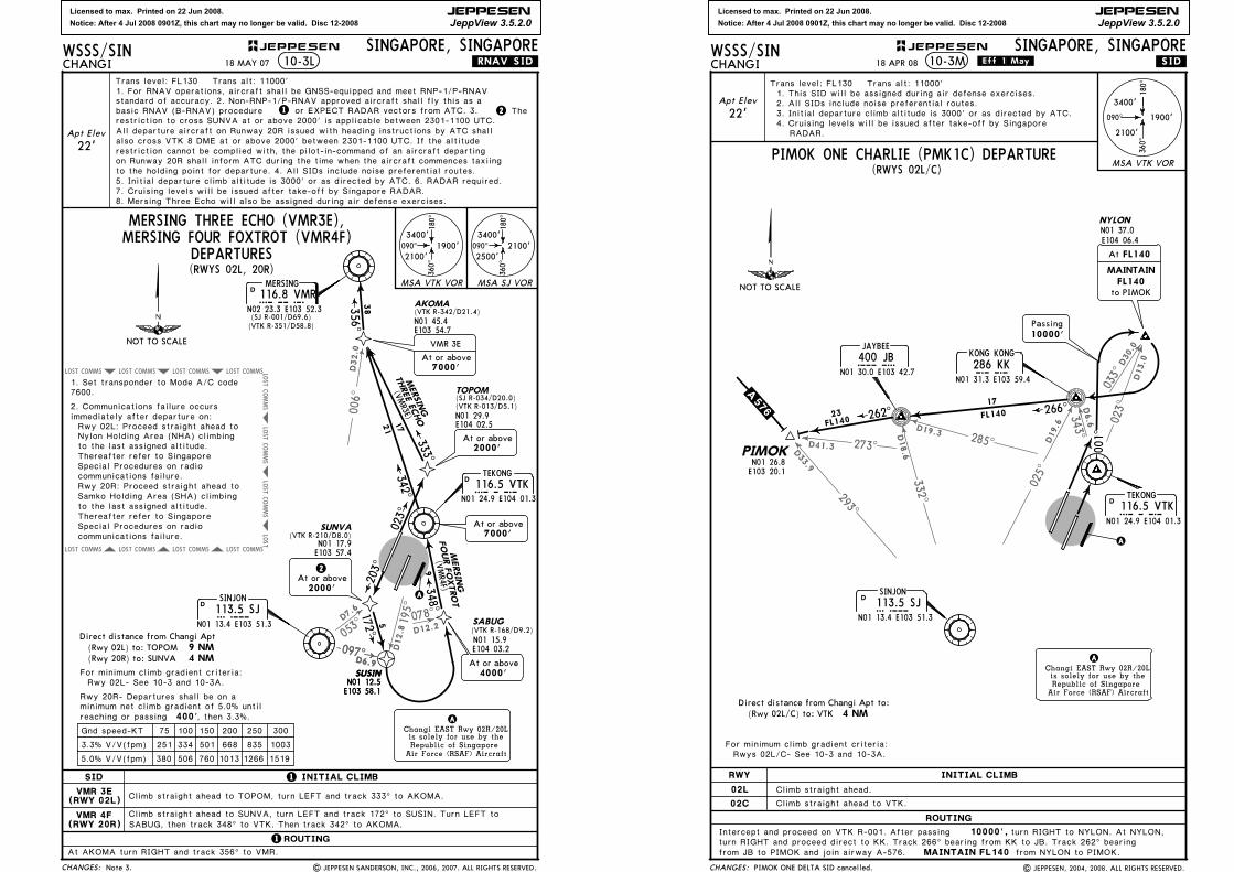
Licensed to max. Printed on 22 Jun 2008.
Notice: After 4 Jul 2008 0901Z, this chart may no longer be valid. Disc 12-2008
JEPPESEN
JeppView 3.5.2.0
195^
D12.8
078^
D12.2
D32.0
006^
053^
D7.6
COMMSLOST COMMSLOST COMMSLOST
COMMS
LOST
COMMS
LOST
COMMS
LOST
LOST
COMMSLOST COMMSLOST COMMSLOST
LOST COMMS
LOST COMMS
097D6.9
097D6.9
75 100 150 200 250 300
9 NM 4 NM
CHANGES:
JEPPESENWSSS/SINCHANGI
SINGAPORE, SINGAPORE
SID
TEKONG
116.5 VTKVTKN01 24.9 E104 01.3
D
10-3L
Direct distance from Changi Apt
Gnd speed-KT
, then 3.3%. 400'
1519126610137605063805.0% V/V(fpm)
3.3% V/V(fpm) 251 334 501 668 835 1003
For minimum climb gradient criteria:
minimum net climb gradient of 5.0% untilreaching or passing
A
Apt Elev
22'
Rwy 20R- Departures shall be on a
.RNAV.SID.
1 INITIAL CLIMB
1ROUTING
Changi EAST Rwy 02R/20Lis solely for use by theRepublic of Singapore
Air Force (RSAF) Aircraft
A
VMR 3E(RWY 02L)
VMR 4F(RWY 20R)
(Rwy 02L) to: TOPOM(Rwy 20R) to: SUNVA
Climb straight ahead to SUNVA, turn LEFT and track 172^ to SUSIN. Turn LEFT to
At AKOMA turn RIGHT and track 356^ to VMR.
Climb straight ahead to TOPOM, turn LEFT and track 333^ to AKOMA.
SABUG, then track 348^ to VTK. Then track 342^ to AKOMA.
348^
342^333^
9
21
17
(VMR4F)
(VMR3E)
THREE ECHO
AKOMA
N01 45.4E103 54.7
(VTK R-342/D21.4)
N01 29.9E104 02.5
(VTK R-013/D5.1)(SJ R-034/D20.0)TOPOM
203^2At or above2000'
N01 17.9E103 57.4
(VTK R-210/D8.0)SUNVA
172^5
2000'At or above
At or above7000'
FOUR FOXTROT
MERSING THREE ECHO (VMR3E),MERSING FOUR FOXTROT (VMR4F)
SINJON
113.5 SJSJN01 13.4 E103 51.3
D
356^
38
MERSING
MERSING
Rwy 02L: Proceed straight ahead to Nylon Holding Area (NHA) climbing
Rwy 20R: Proceed straight ahead to Samko Holding Area (SHA) climbing
to the last assigned altitude.
to the last assigned altitude.
7600.1. Set transponder to Mode A/C code
2. Communications failure occurs immediately after departure on:
Thereafter refer to Singapore Special Procedures on radio communications failure.
Thereafter refer to Singapore Special Procedures on radio communications failure.
(RWYS 02L, 20R)
090^
180^
360^
3400'
2500'2100'090^
180^
360^
3400'
2100'1900'
MSA VTK VOR MSA SJ VORMERSING116.8 VMRVMR
N02 23.3 E103 52.3
D
Rwy 02L- See 10-3 and 10-3A.
(VTK R-351/D58.8)(SJ R-001/D69.6)
DEPARTURES
SUSINN01 12.5E103 58.1
(VTK R-168/D9.2)
SUSINN01 12.5E103 58.1
N01 15.9E104 03.2
At or above4000'
SABUG
18 MAY 07
Note 3. | JEPPESEN SANDERSON, INC., 2006, 2007. ALL RIGHTS RESERVED.
Trans level: FL130 Trans alt: 11000'1. For RNAV operations, aircraft shall be GNSS-equipped and meet RNP-1/P-RNAV standard of accuracy. 2. Non-RNP-1/P-RNAV approved aircraft shall fly this as a
1basic RNAV (B-RNAV) procedure or EXPECT RADAR vectors from ATC. 3. restriction to cross SUNVA at or above 2000' is applicable between 2301-1100 UTC.
2 The
7000'At or above
VMR 3E
All departure aircraft on Runway 20R issued with heading instructions by ATC shall
restriction cannot be complied with, the pilot-in-command of an aircraft departingon Runway 20R shall inform ATC during the time when the aircraft commences taxiingto the holding point for departure. 4. All SIDs include noise preferential routes.5. Initial departure climb altitude is 3000' or as directed by ATC. 6. RADAR required.7. Cruising levels will be issued after take-off by Singapore RADAR.8. Mersing Three Echo will also be assigned during air defense exercises.
also cross VTK 8 DME at or above 2000' between 2301-1100 UTC. If the altitude
023^
NOT TO SCALE
Licensed to max. Printed on 22 Jun 2008.
Notice: After 4 Jul 2008 0901Z, this chart may no longer be valid. Disc 12-2008
JEPPESEN
JeppView 3.5.2.0
343^285^273^
033^
025^
D33.9
293^
D41.3
D19.3
332^
D18.6
D6.6
D19.6
D30.0
D13.0
023^
0 01 ^
090^
180^
360^
3400'
2100'
1900'
CHANGES:
MSA VTK VOR
JEPPESENWSSS/SINCHANGI
SINGAPORE, SINGAPORE
TEKONG116.5 VTKVTK
N01 24.9 E104 01.3
D
10-3M .SID.
Changi EAST Rwy 02R/20Lis solely for use by theRepublic of Singapore
Air Force (RSAF) Aircraft
A
A
KONG KONG
286 KKKKN01 31.3 E103 59.4
JAYBEE
400 JBJBN01 30.0 E103 42.7
NYLON
N01 37.0E104 06.4
to PIMOK
MAINTAINFL140
At FL140
Passing10000'
18 APR 08 .Eff.1.May.
| JEPPESEN, 2004, 2008. ALL RIGHTS RESERVED.
Apt Elev
22'
Trans level: FL130 Trans alt: 11000'
2. All SIDs include noise preferential routes.
4. Cruising levels will be issued after take-off by SingaporeRADAR.
(RWYS 02L/C)
3. Initial departure climb altitude is 3000' or as directed by ATC.
1. This SID will be assigned during air defense exercises.
PIMOK ONE CHARLIE (PMK1C) DEPARTURE
SINJON
113.5 SJSJN01 13.4 E103 51.3
D
4 NM
For minimum climb gradient criteria:Rwys 02L/C- See 10-3 and 10-3A.
Direct distance from Changi Apt to:
ROUTING
10000',
RWY
02L Climb straight ahead.
INITIAL CLIMB
02C Climb straight ahead to VTK.
Intercept and proceed on VTK R-001. After passing
MAINTAIN FL140
turn RIGHT to NYLON. At NYLON,turn RIGHT and proceed direct to KK. Track 266^ bearing from KK to JB. Track 262^ bearingfrom JB to PIMOK and join airway A-576. from NYLON to PIMOK.
PIMOK ONE DELTA SID cancelled.
(Rwy 02L/C) to: VTK
266^
262^17
FL140
NOT TO SCALE
.A.576.PIMOK
N01 26.8E103 20.1
23FL140
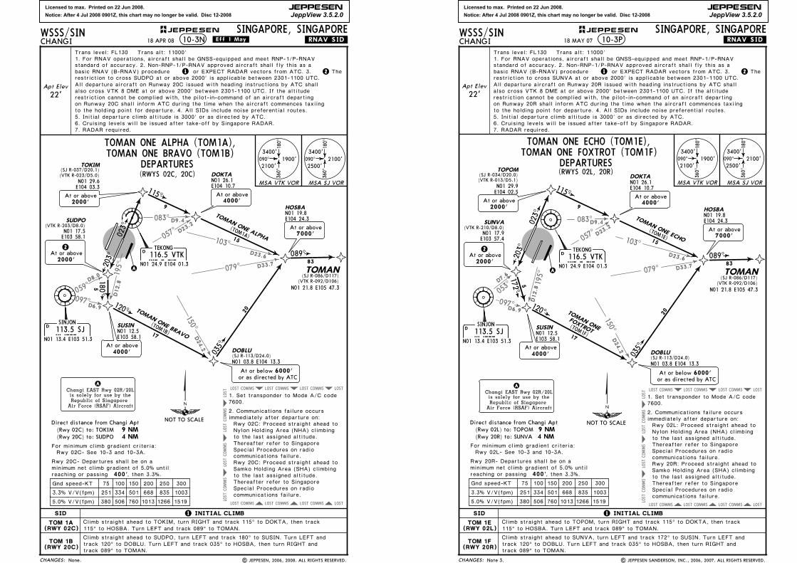
Licensed to max. Printed on 22 Jun 2008.
Notice: After 4 Jul 2008 0901Z, this chart may no longer be valid. Disc 12-2008
JEPPESEN
JeppView 3.5.2.0
083^
057^
059^
097^
195^
150^
D9.4
D23.2
D24.2
D8.0
D6.9
D12.8
COMMSLOST COMMSLOST COMMSLOST LOST
COMMSLOST COMMSLOST COMMSLOST LOST
103^
079^
D23.6
D33.7
COMMS
LOST
COMMS
LOST
COMMS
LOST
LOST
75 100 150 200 250 300
9 NM 4 NM
CHANGES:
JEPPESENWSSS/SINCHANGI
SINGAPORE, SINGAPORE
SID
SINJON
113.5 SJSJN01 13.4 E103 51.3
D
TEKONG116.5 VTKVTK
N01 24.9 E104 01.3
D
10-3N
Direct distance from Changi Apt
Gnd speed-KT
, then 3.3%. 400'
1519126610137605063805.0% V/V(fpm)
3.3% V/V(fpm) 251 334 501 668 835 1003
For minimum climb gradient criteria:
minimum net climb gradient of 5.0% untilreaching or passing
A
Apt Elev
22'
Climb straight ahead to SUDPO, turn LEFT and track 180^ to SUSIN. Turn LEFT and
115^
120^
203^
180^
9
15
17
5
N01 17.5E103 58.1
(VTK R-203/D8.0)SUDPO
N01 12.5E103 58.1
SUSIN
At or above4000'
N01 26.1E104 10.7
DOKTA
2At or above2000'
Rwy 20C- Departures shall be on a
.RNAV.SID.
1 INITIAL CLIMB
Changi EAST Rwy 02R/20Lis solely for use by theRepublic of Singapore
Air Force (RSAF) Aircraft
A
TOM 1A(RWY 02C)
TOM 1B(RWY 20C)
(TOM1A)
(TOM1B)
TOMAN ONE BRAVO
(Rwy 02C) to: TOKIM(Rwy 20C) to: SUDPO
TOKIM(SJ R-037/D20.1)
N01 29.6E104 03.3
(VTK R-023/D5.0)
(SJ R-113/D24.0)DOBLU
N01 03.8 E104 13.3
Rwy 02C: Proceed straight ahead to Nylon Holding Area (NHA) climbing
Rwy 20C: Proceed straight ahead to Samko Holding Area (SHA) climbing
to the last assigned altitude.
to the last assigned altitude.
7600.1. Set transponder to Mode A/C code
2. Communications failure occurs immediately after departure on:
Thereafter refer to Singapore Special Procedures on radio communications failure.
Thereafter refer to Singapore Special Procedures on radio communications failure.
Climb straight ahead to TOKIM, turn RIGHT and track 115^ to DOKTA, then track 115^ to HOSBA. Turn LEFT and track 089^ to TOMAN.
track 120^ to DOBLU. Turn LEFT and track 035^ to HOSBA, then turn RIGHT and track 089^ to TOMAN.
4000'At or above
TOMAN ONE ALPHA
At or belowor as directed by ATC
6000'
2000'At or above
035^
089^
20
83
N01 19.8E104 24.3
HOSBA
At or above7000'
TOMAN(SJ R-086/D117)
(VTK R-092/D106)N01 21.8 E105 47.3
Rwy 02C- See 10-3 and 10-3A.
Trans level: FL130 Trans alt: 11000'1. For RNAV operations, aircraft shall be GNSS-equipped and meet RNP-1/P-RNAV
1 2
18 APR 08
standard of accuracy. 2. Non-RNP-1/P-RNAV approved aircraft shall fly this as a or EXPECT RADAR vectors from ATC. 3.basic RNAV (B-RNAV) procedure The
restriction to cross SUDPO at or above 2000' is applicable between 2301-1100 UTC.
6. Cruising levels will be issued after take-off by Singapore RADAR. 7. RADAR required.
TOMAN ONE ALPHA (TOM1A),TOMAN ONE BRAVO (TOM1B)
DEPARTURES(RWYS 02C, 20C)
090^
360^
3400'
2500'2100'090^
360^
3400'
2100'1900'
MSA VTK VOR MSA SJ VOR
180^
180^
All departure aircraft on Runway 20C issued with heading instructions by ATC shallalso cross VTK 8 DME at or above 2000' between 2301-1100 UTC. If the altituderestriction cannot be complied with, the pilot-in-command of an aircraft departingon Runway 20C shall inform ATC during the time when the aircraft commences taxiing
5. Initial departure climb altitude is 3000' or as directed by ATC. to the holding point for departure. 4. All SIDs include noise preferential routes.
.Eff.1.May.
None. | JEPPESEN, 2006, 2008. ALL RIGHTS RESERVED.
023^
NOT TO SCALE
Licensed to max. Printed on 22 Jun 2008.
Notice: After 4 Jul 2008 0901Z, this chart may no longer be valid. Disc 12-2008
JEPPESEN
JeppView 3.5.2.0
097^
195^
D6.9
D12.8
083^
057^
150^
D9.4
D23.2
D24.2
103^
079^
D23.6
D33.7
COMMSLOST COMMSLOST COMMSLOST LOST
COMMSLOST COMMSLOST COMMSLOST LOST
053^
D7.6
COMMS
LOST
COMMS
LOST
COMMS
LOST
LOST
75 100 150 200 250 300
CHANGES:
JEPPESENWSSS/SINCHANGI
SINGAPORE, SINGAPORE10-3P
Gnd speed-KT
, then 3.3%. 400'
1519126610137605063805.0% V/V(fpm)
3.3% V/V(fpm) 251 334 501 668 835 1003
For minimum climb gradient criteria:
minimum net climb gradient of 5.0% untilreaching or passing
Rwy 20R- Departures shall be on a
.RNAV.SID.
TOMAN ONE ECHO (TOM1E),
9 NM 4 NM
Direct distance from Changi Apt(Rwy 02L) to: TOPOM(Rwy 20R) to: SUNVA
(RWYS 02L, 20R)
SINJON
113.5 SJSJN01 13.4 E103 51.3
D
D
A
120^
N01 12.5E103 58.1
SUSIN
At or above4000'
Changi EAST Rwy 02R/20Lis solely for use by theRepublic of Singapore
Air Force (RSAF) Aircraft
A
TEKONG116.5 VTKVTK
N01 24.9 E104 01.3
15
17
(TOM1E)
(TOM1F)
(SJ R-113/D24.0)DOBLU
N01 03.8 E104 13.3
4000'At or above
At or belowor as directed by ATC
6000'
035^
20
N01 26.1E104 10.7
DOKTA
N01 19.8E104 24.3
HOSBA
At or above7000'
089^83
TOMAN(SJ R-086/D117)
(VTK R-092/D106)
Rwy 02L: Proceed straight ahead to Nylon Holding Area (NHA) climbing
Rwy 20R: Proceed straight ahead to Samko Holding Area (SHA) climbing
to the last assigned altitude.
to the last assigned altitude.
7600.1. Set transponder to Mode A/C code
2. Communications failure occurs immediately after departure on:
Thereafter refer to Singapore Special Procedures on radio communications failure.
Thereafter refer to Singapore Special Procedures on radio communications failure.
SID
Climb straight ahead to SUNVA, turn LEFT and track 172^ to SUSIN. Turn LEFT and
1 INITIAL CLIMB
TOM 1E(RWY 02L)
TOM 1F(RWY 20R)
Climb straight ahead to TOPOM, turn RIGHT and track 115^ to DOKTA, then track 115^ to HOSBA. Turn LEFT and track 089^ to TOMAN.
track 120^ to DOBLU. Turn LEFT and track 035^ to HOSBA, then turn RIGHT and track 089^ to TOMAN.
TOPOM
(VTK R-013/D5.1)(SJ R-034/D20.0)
N01 29.9E104 02.5
203^2
At or above2000'
N01 17.9E103 57.4
(VTK R-210/D8.0)SUNVA
172^5
115^
9
TOMAN ONE FOXTROT (TOM1F)
TOMAN ONE ECHO
TOMAN ONE
FOXTROT
090^
180^
360^
3400'
2500'2100'090^
180^
360^
3400'
2100'1900'
MSA VTK VOR MSA SJ VOR
N01 21.8 E105 47.3
Rwy 02L- See 10-3 and 10-3A.
18 MAY 07
DEPARTURES
| JEPPESEN SANDERSON, INC., 2006, 2007. ALL RIGHTS RESERVED.Note 3.
Apt Elev
22'
Trans level: FL130 Trans alt: 11000'
standard of accuracy. 2. Non-RNP-1/P-RNAV approved aircraft shall fly this as a1. For RNAV operations, aircraft shall be GNSS-equipped and meet RNP-1/P-RNAV
basic RNAV (B-RNAV) procedurerestriction to cross SUNVA at or above 2000' is applicable between 2301-1100 UTC.
1 or EXPECT RADAR vectors from ATC. 3. The2
6. Cruising levels will be issued after take-off by Singapore RADAR. 7. RADAR required.
2000'At or above
All departure aircraft on Runway 20R issued with heading instructions by ATC shallalso cross VTK 8 DME at or above 2000' between 2301-1100 UTC. If the altituderestriction cannot be complied with, the pilot-in-command of an aircraft departingon Runway 20R shall inform ATC during the time when the aircraft commences taxiing
5. Initial departure climb altitude is 3000' or as directed by ATC. to the holding point for departure. 4. All SIDs include noise preferential routes.
023^
NOT TO SCALE
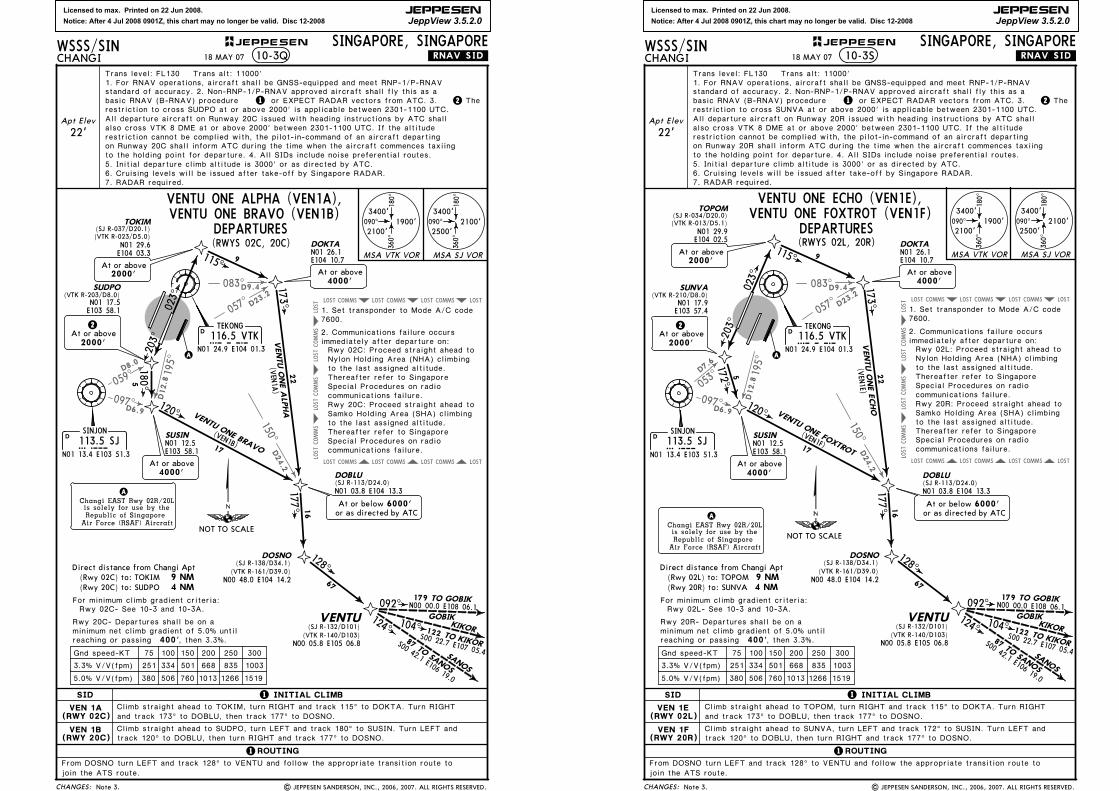
Licensed to max. Printed on 22 Jun 2008.
Notice: After 4 Jul 2008 0901Z, this chart may no longer be valid. Disc 12-2008
JEPPESEN
JeppView 3.5.2.0
083^
057^
059^
097^
195^
150^
D9.4
D23.2
D24.2
D8.0
D6.9
D12.8
COMMSLOST COMMSLOST COMMSLOST LOST
COMMSLOST COMMSLOST COMMSLOST LOST
COMMS
LOST
COMMS
LOST
COMMS
LOST
LOST
75 100 150 200 250 300
9 NM 4 NM
CHANGES:
JEPPESENWSSS/SINCHANGI
SINGAPORE, SINGAPORE
SID
SINJON
113.5 SJSJN01 13.4 E103 51.3
D
TEKONG
116.5 VTKVTKN01 24.9 E104 01.3
D
10-3Q
Direct distance from Changi Apt
Gnd speed-KT
, then 3.3%. 400'
1519126610137605063805.0% V/V(fpm)
3.3% V/V(fpm) 251 334 501 668 835 1003
For minimum climb gradient criteria:
minimum net climb gradient of 5.0% untilreaching or passing
A
Climb straight ahead to SUDPO, turn LEFT and track 180^ to SUSIN. Turn LEFT and
Climb straight ahead to TOKIM, turn RIGHT and track 115^ to DOKTA. Turn RIGHT
115^
173^
120^
203^
180^
128^
9
22
16
67
17
5
N01 17.5E103 58.1
(VTK R-203/D8.0)SUDPO
N01 12.5E103 58.1
SUSIN
At or above4000'
N01 26.1E104 10.7
DOKTA
2At or above2000'
Rwy 20C- Departures shall be on a
.RNAV.SID.
1 INITIAL CLIMB
1ROUTING
Changi EAST Rwy 02R/20Lis solely for use by theRepublic of Singapore
Air Force (RSAF) Aircraft
A
VEN 1A(RWY 02C)
VEN 1B(RWY 20C)
DOSNO
VENTU
N00 48.0 E104 14.2
N00 05.8 E105 06.8
VENTU ONE ALPHA
(VEN
1A)
(VEN1B)
VENTU ONE BRAVO
(Rwy 02C) to: TOKIM(Rwy 20C) to: SUDPO
TOKIM(SJ R-037/D20.1)
N01 29.6E104 03.3
(VTK R-023/D5.0)
2000'At or above
(SJ R-113/D24.0)DOBLU
N01 03.8 E104 13.3
Rwy 02C: Proceed straight ahead to Nylon Holding Area (NHA) climbing
Rwy 20C: Proceed straight ahead to Samko Holding Area (SHA) climbing
to the last assigned altitude.
to the last assigned altitude.
7600.1. Set transponder to Mode A/C code
2. Communications failure occurs immediately after departure on:
Thereafter refer to Singapore Special Procedures on radio communications failure.
Thereafter refer to Singapore Special Procedures on radio communications failure.
177^
(SJ R-132/D101)
and track 173^ to DOBLU, then track 177^ to DOSNO.
VENTU ONE ALPHA (VEN1A),
join the ATS route.
(SJ R-138/D34.1)
N00 00.0 E108 06.1
S00 22.7 E107 05.4S00 42.1 E106 19.0
GOBIKKIKOR
SANOS
122 TO KIKOR87 TO SA
NOS
179 TO GOBIK092^
104^124^
(VTK R-161/D39.0)
(VTK R-140/D103)
From DOSNO turn LEFT and track 128^ to VENTU and follow the appropriate transition route to
At or belowor as directed by ATC
6000'
090^
180^
360^
3400'
2500'2100'090^
180^
360^
3400'
2100'1900'
MSA VTK VOR MSA SJ VOR
(RWYS 02C, 20C)
VENTU ONE BRAVO (VEN1B)
4000'At or above
Rwy 02C- See 10-3 and 10-3A.
track 120^ to DOBLU, then turn RIGHT and track 177^ to DOSNO.
18 MAY 07
DEPARTURES
| JEPPESEN SANDERSON, INC., 2006, 2007. ALL RIGHTS RESERVED.Note 3.
Apt Elev
22'
basic RNAV (B-RNAV) procedurestandard of accuracy. 2. Non-RNP-1/P-RNAV approved aircraft shall fly this as a
Trans level: FL130 Trans alt: 11000'1. For RNAV operations, aircraft shall be GNSS-equipped and meet RNP-1/P-RNAV
or EXPECT RADAR vectors from ATC. 3.1 2 Therestriction to cross SUDPO at or above 2000' is applicable between 2301-1100 UTC.
6. Cruising levels will be issued after take-off by Singapore RADAR. 7. RADAR required.
All departure aircraft on Runway 20C issued with heading instructions by ATC shallalso cross VTK 8 DME at or above 2000' between 2301-1100 UTC. If the altituderestriction cannot be complied with, the pilot-in-command of an aircraft departingon Runway 20C shall inform ATC during the time when the aircraft commences taxiing
5. Initial departure climb altitude is 3000' or as directed by ATC. to the holding point for departure. 4. All SIDs include noise preferential routes.
023^
NOT TO SCALE
Licensed to max. Printed on 22 Jun 2008.
Notice: After 4 Jul 2008 0901Z, this chart may no longer be valid. Disc 12-2008
JEPPESEN
JeppView 3.5.2.0
083^
057^
097^
195^
150^
D9.4
D23.2
D24.2
D6.9
D12.8
COMMSLOST COMMSLOST COMMSLOST LOST
COMMSLOST COMMSLOST COMMSLOST LOST
053^
D7.6
COMMS
LOST
COMMS
LOST
COMMS
LOST
LOST
75 100 150 200 250 300
CHANGES:
JEPPESENWSSS/SINCHANGI
SINGAPORE, SINGAPORE
SID
SINJON
113.5 SJSJN01 13.4 E103 51.3
D
TEKONG116.5 VTKVTK
N01 24.9 E104 01.3
D
10-3S
Gnd speed-KT
1519126610137605063805.0% V/V(fpm)
3.3% V/V(fpm) 251 334 501 668 835 1003
A
Climb straight ahead to SUNVA, turn LEFT and track 172^ to SUSIN. Turn LEFT and
Climb straight ahead to TOPOM, turn RIGHT and track 115^ to DOKTA. Turn RIGHT
173^
120^
128^
22
16
67
17N01 12.5E103 58.1
SUSIN
At or above4000'
N01 26.1E104 10.7
DOKTA
.RNAV.SID.
1 INITIAL CLIMB
1ROUTING
Changi EAST Rwy 02R/20Lis solely for use by theRepublic of Singapore
Air Force (RSAF) Aircraft
A
VEN 1E(RWY 02L)
VEN 1F(RWY 20R)
DOSNO
VENTU
N00 48.0 E104 14.2
N00 05.8 E105 06.8
(VEN
1E)
(VEN1F)
(SJ R-113/D24.0)DOBLU
N01 03.8 E104 13.3
Rwy 02L: Proceed straight ahead to Nylon Holding Area (NHA) climbing
Rwy 20R: Proceed straight ahead to Samko Holding Area (SHA) climbing
to the last assigned altitude.
to the last assigned altitude.
7600.1. Set transponder to Mode A/C code
2. Communications failure occurs immediately after departure on:
Thereafter refer to Singapore Special Procedures on radio communications failure.
Thereafter refer to Singapore Special Procedures on radio communications failure.
177^
(SJ R-132/D101)
and track 173^ to DOBLU, then track 177^ to DOSNO.
VENTU ONE ECHO (VEN1E),
join the ATS route.
(SJ R-138/D34.1)
N00 00.0 E108 06.1
S00 22.7 E107 05.4S00 42.1 E106 19.0
GOBIKKIKOR
SANOS
122 TO KIKOR87 TO SA
NOS
179 TO GOBIK092^
104^124^
(VTK R-161/D39.0)
(VTK R-140/D103)
From DOSNO turn LEFT and track 128^ to VENTU and follow the appropriate transition route to
At or belowor as directed by ATC
6000'
(RWYS 02L, 20R)
VENTU ONE FOXTROT (VEN1F)
4000'At or above
N01 29.9E104 02.5
(VTK R-013/D5.1)
TOPOM(SJ R-034/D20.0)
2000'At or above
N01 17.9E103 57.4
(VTK R-210/D8.0)SUNVA
2At or above2000'
172^5
203^
115^ 9
For minimum climb gradient criteria:
minimum net climb gradient of 5.0% untilRwy 20R- Departures shall be on a
9 NM 4 NM
Direct distance from Changi Apt(Rwy 02L) to: TOPOM(Rwy 20R) to: SUNVA
, then 3.3%. 400'reaching or passing
090^
180^
360^
3400'
2500'2100'090^
180^
360^
3400'
2100'1900'
MSA VTK VOR MSA SJ VORVENTU ONE ECHO
VENTU ONE FOXTROT
Rwy 02L- See 10-3 and 10-3A.
track 120^ to DOBLU, then turn RIGHT and track 177^ to DOSNO.
DEPARTURES
Note 3. | JEPPESEN SANDERSON, INC., 2006, 2007. ALL RIGHTS RESERVED.
18 MAY 07
Trans level: FL130 Trans alt: 11000'1. For RNAV operations, aircraft shall be GNSS-equipped and meet RNP-1/P-RNAV standard of accuracy. 2. Non-RNP-1/P-RNAV approved aircraft shall fly this as a
1 or EXPECT RADAR vectors from ATC. 3. 2 Thebasic RNAV (B-RNAV) procedurerestriction to cross SUNVA at or above 2000' is applicable between 2301-1100 UTC.
6. Cruising levels will be issued after take-off by Singapore RADAR. 7. RADAR required.
Apt Elev
22'All departure aircraft on Runway 20R issued with heading instructions by ATC shallalso cross VTK 8 DME at or above 2000' between 2301-1100 UTC. If the altituderestriction cannot be complied with, the pilot-in-command of an aircraft departingon Runway 20R shall inform ATC during the time when the aircraft commences taxiing
5. Initial departure climb altitude is 3000' or as directed by ATC. to the holding point for departure. 4. All SIDs include noise preferential routes.
023^
NOT TO SCALE

Licensed to max. Printed on 22 Jun 2008.
Notice: After 4 Jul 2008 0901Z, this chart may no longer be valid. Disc 12-2008
JEPPESEN
JeppView 3.5.2.0
Apt Elev
SINGAPORE Delivery (Cpt) Ground Tower
128.6 121.65 124.3 121.72*East of Terminal 2
118.6
D-ATIS ACARS:D-ATIS
the direction of Twy A7.
104-00103-59
follow the Twy centerline whiletaxiing along Twy WC.
Elev 15'
FOR PARKING POSITIONSSEE CHART 10-9B
D48 and D49. A mandatory instruction sign with the
the eastern side of Twy A6 before the turn into Twy A1
Pilots are advised to apply Minimum thrust when turninginto Twy A1 while taxiing either northwards or southwards on Twy A6, and thereafter when taxiing along Twy A1 upto and including the Twy A7 - A1 junction.This is in view of apron activities of aircraft stands D47,
inscription "APPLY MNM THRUST" has been installed along
from the north as well as from the south.
from Twy EP to Twy A7 only. No-entry signs have
Taxiway centerline lights along Twy A2 have beenshielded to provide guidance only from Twy EP in
Twy A2 is a one-way taxiway for aircraft taxiing
been mounted on either side of Twy A2 along Twy A7.
01-20 01-20
01-21
01-22 01-22
01-23 01-23
stands 506, 507 and 508 diverted138' westward. Pilots to
Rwy 02R/20LT2
SOUTH APRON
Twy WC centerline behind aircraft
01^E
SOUTH-EASTREMOTE APRON
oversteering may be required whenmaneuvering round taxiway turns.
Pilots operating aircraft with wheelbase longer than B747 or 85'shall take note that judgemental
APRON
BUDGETTERMINAL
L8
L5
L6
L7
L4
West of Terminal 2
with a maximum wingspan of213'(65m).
Twys L5 and L8 restricted toaircraft with a maximum wingspan
(36m).of 118'
Taxiway centerline along Twy EPbetween Twy B1 and B3 offseteastward by 2.5 m away from aircraft stands E7 and F36.
Pilots are advised to applyminimum thrust when turninginto taxiway WA from Aprontaxilane V6.
Apron taxilane V8 can onlybe used by aircraft withmaximum wingspan of 200'(61m).
7 MAR 08
T3 SOUTH APRON
Terminal 3 added. | JEPPESEN, 1998, 2008. ALL RIGHTS RESERVED.
1
1
NORTH
APRON
Bldg Area
N01 21.6 E103 59.4 CHANGI10-922'SINGAPORE, SINGAPORE
CHANGES:
WSSS/SIN
02L
177'
EP
Bldg Area
Elev 22'
E11
E10
E9
E8
E7
197' Stopway
60m
5 min, see 10-9D and 10-9E.
023^
13,123
'4000m
197'60mStopway
023^
02C
Bldg Area
Bldg Area
T2 CENTRAL APRON
T2 NORTH APRON
REMOTE APRON
CHANGI EAST(MILITARY ONLY)
(42m)
(26m)
138'
C6
E3
E4
EP
279'
WPWA
TERMINAL2
E5
13,123
'4000m
Bldg Area
A4
C3
C1
C2
B2
B1
B3
C7 EP
C1
A5
T1 EAST APRON
W10
W6
V6W7
V7
V8W8
W9
WA
U2
SC2
SC1
SC1
SC2
20CElev 15'
197'60m Stopway
20RElev 15'
243'
164'
WP
EA
SERVICEAPRON
EASTCARGOAPRONWCW3
W2
W1
APRONCARGOWEST
WP
197'60m Stopway
203^
203^
FuelFarm
NORTH
NC1SERVICEAPRON
EAST
V3
V4
WP
WA
ARP
CENTRALAPRON
1TERMINAL
E1
E2
W4NC2
EA
AIS
MET
A1
A2 A6
A3
NC2
NC1NORTHREMOTE APRON
T1
T1 W
EST APRON
N1N2 N3
N3N1
NC3W5
VY
VZU1
U1
JEPPESEN
Feet
Meters
0
0
1000
1000
2000 3000 4000 5000
1500500
A7
A7A3
SC1E6
SC2
NORTH-EAST
A6
EAST REMOTE
0001Z-1600Z
Twy NC3 restricted to aircraft
T3
U3
Pushback clearance expires in
Control Tower
Licensed to max. Printed on 22 Jun 2008.
Notice: After 4 Jul 2008 0901Z, this chart may no longer be valid. Disc 12-2008
JEPPESEN
JeppView 3.5.2.0
applicable when Runway 20C/02C is unavailable because of maintenance work or for other reasons.Departures on Runway 20R are not permitted between 1600/2200 UTC. However, this restriction is not
None.
7 MAR 08
| JEPPESEN, 1998, 2008. ALL RIGHTS RESERVED.
RWY
ADDITIONAL RUNWAY INFORMATION
ThresholdLANDING BEYOND
USABLE LENGTHS
WIDTHTAKE-OFFGlide Slope
GENERAL
RVR RVR
RVR RVR
02L20R
02C20C
11
1 Angle 3.0^.
Angle 3.0^.
12,008' 197'
197'
3660m
2930m 60m
60m
All Rwys
Eng
3 & 4Eng
TAKE-OFF
All Rwys
AIR CARRIER (FAR 121)
400m
ABCD
2 TDZ RVR
MID RVR
Rollout RVR
RVR
VIS
175m
CL & RCLM
CHANGI10-9A
Due to close proximity of Paya Lebar and Seletar airports, correct approach is vital.
2
2
500m
SINGAPORE, SINGAPORE
any RVR out, Adequate Vis Ref
250m (200m)
200m (150m) 250m
300m
Low-level wind shear alert system.
3687m
3664m12,021'12,096'
other two required
2
Maritime vessels of variable heights off Changi Apt.Birds in vicinity of airport.
3260m 9613'
CHANGES:
JEPPESEN
HIRL CL ALSF-II TDZ REILHIRL CL ALSF-I REIL PAPI
HIRL CL ALSF-I REILHIRL CL ALSF-II TDZ REIL PAPI-L
10,696'PAPI
PAPI
RL & CL
400m
RCLM (DAY only)or RL
RCLM (DAY only)or RL
AIR CARRIER (JAA) LVP must be in Force
All RwysAll Rwys
WSSS/SIN
175m
175m
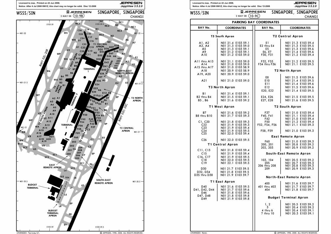
Licensed to max. Printed on 22 Jun 2008.
Notice: After 4 Jul 2008 0901Z, this chart may no longer be valid. Disc 12-2008
JEPPESEN
JeppView 3.5.2.0
F32F31F30
E1E2E3E4
E5
E10 E11E12
C19
C18
C17
C16
104103
N01-21
N01-22 N01-22
N01-21
N01-21.5
N01-20.5
N01-21.5
E103-59 E103-59.5
N01-20.5
E103-59 E103-59.5
2TERMINAL
23456789
10
1
| JEPPESEN, 1998, 2008. ALL RIGHTS RESERVED.Taxiway U1.
2 MAY 08SINGAPORE, SINGAPORE
10-9B CHANGIWSSS/SIN
RWY 02L-20R
RWY 02C-20C
E3
E4
EP
EP
E1
E2
E5
WPD46
D44
D42
E24
E22
E20
E28
E27
E26
F50
F52
C22
C23
D34
D32
D30
C15
C13
C11
APRON
D41
D40
EP
A4
C6
F36F35F34
F42
F37
A7
C1
C2
F33B3
B1
E6E7
T2 CENTRALAPRON
SOUTH-EAST
B2
F41F40
A2
A3
C7
E8
A5
400401402
E6
A7
N1
NC3
CHANGES:
NC2 NC1
NC1
T2 SOUTH APRON
T1 EAST APRON
T1 CENTRAL
C24
C25
C26
REMOTE APRON
APRONT2 NORTH
403404
NORTH-EASTREMOTE APRON
WA
N2
N3
D35 D36D37
D38
D47D48
D49
A6
A6
A6
W5
VYW6
V6
W7
N3
N1
VZ
WA
WA
NC3
F54
F56
F58
F59
F60
201
203
202
200
C3C6
205206207208209
REMOTE APRONEAST
U2
SC1
SC2
SC2
WP
V7
WA
SC1
SC2
E7
EP
E8
L8
L7
L6
A1
N3
N1
W10
W8
W9
BUDGET
TERMINAL
E9
U1
NC2EA
V8 A17 A21A20
A19A18
A16A15
A14A13
A12
A11
A10
V8
U3
U1
A4
A3
A2
B2
B3B4 B5
B6
B7
C1
C20
TERMINAL 3
B1
B8
B9
B10
A1
A5
A9
L5
L4
1
BUDGETTERMINALAPRON
T3 SOUTH APRON
T1 WEST APRON
TERMINAL
B2
JEPPESEN
T3NORTH
APRON
A1
U1
Licensed to max. Printed on 22 Jun 2008.
Notice: After 4 Jul 2008 0901Z, this chart may no longer be valid. Disc 12-2008
JEPPESEN
JeppView 3.5.2.0
N01 21.9 E103 59.4
N01 22.0 E103 59.5N01 22.1 E103 59.5
C18C19
N01 21.9 E103 59.5C15
C16, C17
C26 N01 22.0 E103 59.5
None. | JEPPESEN, 1998, 2008. ALL RIGHTS RESERVED.
2 MAY 08 CHANGI
PARKING BAY COORDINATES
COORDINATES COORDINATESBAY No.BAY No.
SINGAPORE, SINGAPORE10-9C
CHANGES:
JEPPESENWSSS/SIN
N01 21.0 E103 59.4F42F40, F41
F37 N01 21.0 E103 59.4N01 21.1 E103 59.4
N01 21.2 E103 59.4N01 21.1 E103 59.3
N01 21.0 E103 59.3
F52, F54, F56F50
T2 South Apron
400
North-East Remote Apron
404
N01 21.6 E103 59.7N01 21.7 E103 59.7N01 21.8 E103 59.7
401 thru 403
South-East Remote Apron
205206 thru 208
209 N01 20.9 E103 59.3N01 20.8 E103 59.3N01 20.7 E103 59.3N01 20.5 E103 59.2103, 104
E11
E8E10
E12E20, E22
T2 North Apron
N01 21.5 E103 59.6
N01 21.4 E103 59.6N01 21.4 E103 59.5
N01 21.5 E103 59.6N01 21.4 E103 59.5
N01 21.5 E103 59.5E24, E26N01 21.6 E103 59.5E27, E28
N01 21.3 E103 59.4N01 21.3 E103 59.5N01 21.3 E103 59.6N01 21.4 E103 59.6
E1E2 thru E4
E5E6, E7
F34 thru F36
F30, F31 N01 21.2 E103 59.4
N01 21.2 E103 59.5N01 21.1 E103 59.5
T2 Central Apron
F32, F33
T1 East Apron
N01 21.8 E103 59.6N01 21.8 E103 59.8N01 21.9 E103 59.8
N01 21.7 E103 59.6D41, D42, D44D46
D47, D48
N01 21.6 E103 59.5
D49
D40
T1 Central Apron
N01 21.8 E103 59.4C11, C13
D30 N01 21.7 E103 59.5N01 21.8 E103 59.5N01 21.9 E103 59.7D35 thru D38
D32, D34
N01 21.8 E103 59.3C22 N01 21.9 E103 59.3
N01 21.9 E103 59.4C23N01 21.9 E103 59.5
T3 North Apron
N01 22.0 E103 59.4C24C25
N01 21.3 E103 59.0
N01 21.5 E103 59.1
A3, A4
B2 thru B4N01 21.6 E103 59.2
East Remote Apron
200, 201202, 203 N01 20.9 E103 59.2
N01 20.8 E103 59.2
N01 21.2 E103 59.0A10
N01 21.1 E103 59.0A14 N01 21.0 E103 59.0
N01 21.0 E103 58.9A15 thru A17A18 N01 20.9 E103 58.9
N01 20.9 E103 59.0A19, A20
A21 N01 21.0 E103 59.0
N01 21.4 E103 59.1A1, A2
N01 21.3 E103 59.1A5N01 21.2 E103 59.1A9
A11 thru A13
N01 21.4 E103 59.1B1
N01 21.7 E103 59.3B8 thru B10
C1, C20
T3 South Apron
B5 , B6
N01 21.6 E103 59.2B7
T1 West Apron
F58, F59
N01 21.0 E103 59.3F60
Budget Terminal Apron
N01 20.4 E103 59.231, 2
4 thru 67 thru 10
N01 20.5 E103 59.2
N01 20.4 E103 59.1N01 20.3 E103 59.1
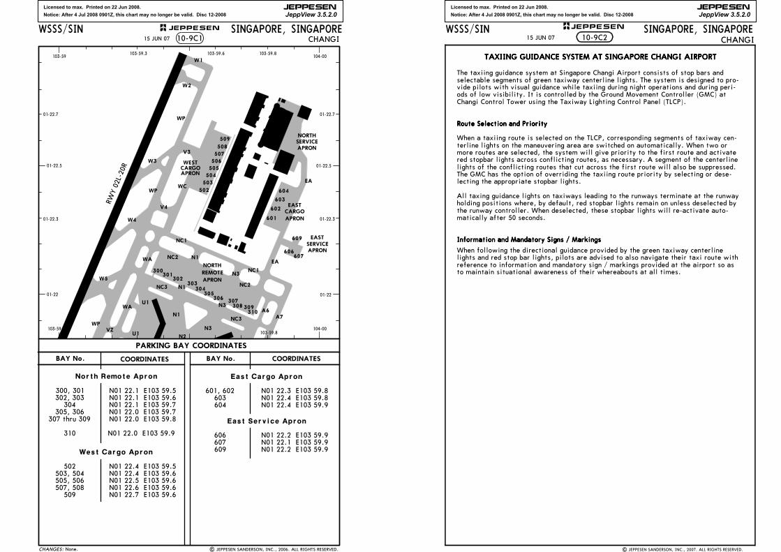
Licensed to max. Printed on 22 Jun 2008.
Notice: After 4 Jul 2008 0901Z, this chart may no longer be valid. Disc 12-2008
JEPPESEN
JeppView 3.5.2.0
N01 22.0 E103 59.7N01 22.1 E103 59.7304
305, 306N01 22.0 E103 59.8307 thru 309
310
509 N01 22.7 E103 59.6
505
506
504
503
502
507
508
509
604
603
602
601
606607
609
300301
302303
304305
306 307308 309
310
| JEPPESEN SANDERSON, INC., 2006. ALL RIGHTS RESERVED.
103-59 104-00
01-22.5
01-22
01-22.5
01-22
103-59 104-00
103-59.3 103-59.6 103-59.8
01-22.7
01-22.3
01-22.7
01-22.3
103-59.8
15 JUN 07
None.
CHANGISINGAPORE, SINGAPORE
CHANGES:
WSSS/SIN
N01 22.1 E103 59.5N01 22.1 E103 59.6
North Remote Apron
302, 303300, 301
N01 22.0 E103 59.9
West Cargo Apron
503, 504505, 506507, 508
N01 22.4 E103 59.6N01 22.5 E103 59.6N01 22.6 E103 59.6
N01 22.4 E103 59.5502
East Service Apron
606607609
N01 22.2 E103 59.9N01 22.1 E103 59.9N01 22.2 E103 59.9
603601, 602
604
N01 22.3 E103 59.8N01 22.4 E103 59.8N01 22.4 E103 59.9
East Cargo Apron
WP
EA
SERVICEAPRON
EASTCARGOAPRON
WC
W3
W2
W1
APRONCARGOWEST
NORTH
NC1SERVICEAPRON
EAST
V3
V4
WP
W4
NC2EA
NC2
NC1NORTH
N1
N2
N3
N3
N1
NC3
W5
VZU1
A7A6
10-9C1
NC3
N1
N3
WP
WA
WAU1
APRON
REMOTE
PARKING BAY COORDINATES
COORDINATESBAY No. BAY No. COORDINATES
RWY 02L-20R
JEPPESEN
Licensed to max. Printed on 22 Jun 2008.
Notice: After 4 Jul 2008 0901Z, this chart may no longer be valid. Disc 12-2008
JEPPESEN
JeppView 3.5.2.0
SINGAPORE, SINGAPORECHANGI
WSSS/SIN JEPPESEN+
TAXIING GUIDANCE SYSTEM AT SINGAPORE CHANGI AIRPORTTAXIING GUIDANCE SYSTEM AT SINGAPORE CHANGI AIRPORTTAXIING GUIDANCE SYSTEM AT SINGAPORE CHANGI AIRPORTTAXIING GUIDANCE SYSTEM AT SINGAPORE CHANGI AIRPORT
The taxiing guidance system at Singapore Changi Airport consists of stop bars andselectable segments of green taxiway centerline lights. The system is designed to pro-vide pilots with visual guidance while taxiing during night operations and during peri-ods of low visibility. It is controlled by the Ground Movement Controller (GMC) atChangi Control Tower using the Taxiway Lighting Control Panel (TLCP).
Route Selection and PriorityRoute Selection and PriorityRoute Selection and PriorityRoute Selection and Priority
When a taxiing route is selected on the TLCP, corresponding segments of taxiway cen-terline lights on the maneuvering area are switched on automatically. When two ormore routes are selected, the system will give priority to the first route and activatered stopbar lights across conflicting routes, as necessary. A segment of the centerlinelights of the conflicting routes that cut across the first route will also be suppressed.The GMC has the option of overriding the taxiing route priority by selecting or dese-lecting the appropriate stopbar lights.
All taxing guidance lights on taxiways leading to the runways terminate at the runwayholding positions where, by default, red stopbar lights remain on unless deselected bythe runway controller. When deselected, these stopbar lights will re-activate auto-matically after 50 seconds.
Information and Mandatory Signs / MarkingsInformation and Mandatory Signs / MarkingsInformation and Mandatory Signs / MarkingsInformation and Mandatory Signs / Markings
When following the directional guidance provided by the green taxiway centerlinelights and red stop bar lights, pilots are advised to also navigate their taxi route withreference to information and mandatory sign / markings provided at the airport so asto maintain situational awareness of their whereabouts at all times.
10-9C215 JUN 07
| JEPPESEN SANDERSON, INC., 2007. ALL RIGHTS RESERVED.

Licensed to max. Printed on 22 Jun 2008.
Notice: After 4 Jul 2008 0901Z, this chart may no longer be valid. Disc 12-2008
JEPPESEN
JeppView 3.5.2.0
SINGAPORE, SINGAPORECHANGI
WSSS/SIN JEPPESEN+
PROCEDURES FOR PUSH BACK AND ASSIGNMENT OFPROCEDURES FOR PUSH BACK AND ASSIGNMENT OFPROCEDURES FOR PUSH BACK AND ASSIGNMENT OFPROCEDURES FOR PUSH BACK AND ASSIGNMENT OFFLIGHT LEVELS TO DEPARTING AIRCRAFTFLIGHT LEVELS TO DEPARTING AIRCRAFTFLIGHT LEVELS TO DEPARTING AIRCRAFTFLIGHT LEVELS TO DEPARTING AIRCRAFT
GENERALGENERALGENERALGENERAL
a. Assignment of flight levels to departing aircraft is made on a first-come-first-served basis. Aircraft will normally be assigned the level requested unless analternate level is offered after coordination with the adjacent ATC centers.
b. Departing flights from Singapore requesting FL 280 or FL 320 on L759,M770, N571, N571/N877 or P628.
1. Aircraft departing Singapore will be cleared to FL 280.
2. Succeeding aircraft on the same route will be cleared to FL 280 with 10 min lon-gitudinal separation provided there is no closing speed with the preceding air-craft.
3. Additional longitudinal separation as appropriate shall be provided by ATC forthe faster aircraft following a slower aircraft on the same route.
4. The first aircraft from either Singapore or Kuala Lumpur to be over GUNIP onN571 or N571/N877, the Kuala Lumpur/Bangkok FIR boundary on M770 or L759and VPL on P628 can expect its requested flight level.
c. To avoid confusion, pilots shall use the correct phraseology as detailed inPROCEDURESPROCEDURESPROCEDURESPROCEDURES paragraph a. when ready for push back.
d. A Multilateration Surveillance System (MSS) is operational at Changi airport. TheMode S MSS will provide the controller with surveillance and identification of allaircraft and transponder equipped vehicles on the airport surface. Procedures/Actions required by pilots pre-push back/taxi:
1. The pilot will be requested to enter a Mode A code at start-up (i.e. assignedMode A code). This code will be either a discrete or non-discrete code (A con-spicuous code E.G. 1000). Pilot shall ensure that the transponder is operating(i.e. XPNDR or the equivalent according to specific installation, auto if avail-able, not OFF or SDBY) and the assigned Mode A code is selected from therequest for pushback or taxi, whichever is earlier.
2. Whenever the aircraft is capable of reporting aircraft identification (i.e. theICAO callsign used in flight inserted in the FMS (Flight Management System) ortransponder control panel) the aircraft’s identification should also be enteredfrom the request for pushback or taxi whichever is earlier, through the FMS(Flight Management System) or the transponder control panel. Flight crew mustuse the 3-letter ICAO designator of the operator, followed by the Flight Identi-fication number (i.e. BAW123, SIA002). After landing, pilots shall ensure thatthe transponder is operating (i.e. XPNDR or the equivalent according to specificinstallation, auto if available, not OFF or SDBY) after landing, continuouslyuntil the aircraft is fully parked on the stand.
PROCEDURESPROCEDURESPROCEDURESPROCEDURES
a. The pilot shall notify ATC when the aircraft is ready to push back within 5 min usingthe following phraseology:
^ call sign
^ destination
^ proposed flight level and alternate level, if any
^ parking position
^ 'ready to push back in 5 minutes '
b. On receipt of the 'ready to push back ' call, ATC will advise the pilot whether theproposed flight level or other alternate flight level is available and an ATC clear-ance will be issued accordingly. If pre-departure coordination with an adjacent unitor center is required, the pilot will be instructed to standby.
c. Once the flight level is accepted by the pilot and an ATC clearance issued, the air-craft must be pushed back within 5 minutes from the time the ATC clearance isaccepted unless other ATC restrictions are imposed. The ATC clearance will be can-celed upon expiration of the 5 minute grace period.
10-9D25 JAN 08
| JEPPESEN SANDERSON, INC., 1999, 2008. ALL RIGHTS RESERVED.
Licensed to max. Printed on 22 Jun 2008.
Notice: After 4 Jul 2008 0901Z, this chart may no longer be valid. Disc 12-2008
JEPPESEN
JeppView 3.5.2.0
SINGAPORE, SINGAPORECHANGI
WSSS/SIN JEPPESEN+
d. At the end of the push back, the departing aircraft must have all engines startedand be ready to taxi immediately, unless otherwise instructed by ATC.
NOTE: The first aircraft to taxi may not necessarily be the first aircraft to take-off as distances between aircraft stands and the departure runway vary.
DELAY IN PUSH BACK AND/OR TAXI DUE TO OTHER AIRCRAFTDELAY IN PUSH BACK AND/OR TAXI DUE TO OTHER AIRCRAFTDELAY IN PUSH BACK AND/OR TAXI DUE TO OTHER AIRCRAFTDELAY IN PUSH BACK AND/OR TAXI DUE TO OTHER AIRCRAFT
Delays may be expected for the second aircraft to push back and to taxi when two ormore aircraft are parked either adjacent to one another or close together. However, itwill retain its ATC clearance even if the 5 minutes grace period allowed for underPROCEDURESPROCEDURESPROCEDURESPROCEDURES paragraph c. is exceeded.
DELAY IN TAKE-OFF DUE TO RESTRICTIONS IN THE ATC CLEARANCEDELAY IN TAKE-OFF DUE TO RESTRICTIONS IN THE ATC CLEARANCEDELAY IN TAKE-OFF DUE TO RESTRICTIONS IN THE ATC CLEARANCEDELAY IN TAKE-OFF DUE TO RESTRICTIONS IN THE ATC CLEARANCE
The ATC clearance may require an aircraft to arrive at a reporting point at a specifictime and level or to depart a number of minutes behind a preceding traffic to establishlongitudinal separation. Such a delay will not deprive a departing aircraft of its ATCclearance even though the 5 minutes grace period would have been exceeded.
DELAY DUE TO OVERFLIGHTSDELAY DUE TO OVERFLIGHTSDELAY DUE TO OVERFLIGHTSDELAY DUE TO OVERFLIGHTS
These are flights operating through Singapore FIR without landing at Changi Airport.Depending on their positions, a departing aircraft requesting the same level may haveto accept an alternate level or may have to delay its departure in order to establishthe prescribed separation.
FLIGHTS EXEMPTEDFLIGHTS EXEMPTEDFLIGHTS EXEMPTEDFLIGHTS EXEMPTED
The above procedures are not applicable to VIP, CASEVAC, SAR and other special tasksaircraft. ATC shall have full discretion in the conduct of such operations.
CANCELLATION OF ATC CLEARANCECANCELLATION OF ATC CLEARANCECANCELLATION OF ATC CLEARANCECANCELLATION OF ATC CLEARANCE
a. A departing aircraft may have its ATC clearance cancelled under the following cir-cumstances:
1. on expiry of the 5 minutes grace period under PROCEDURESPROCEDURESPROCEDURESPROCEDURES paragraph c., it is until unable to push back; or
2. after pushing back, the pilot advises that it is returning to blocks; or
3. it develops a technical problem and is unable to continue taxiing.
b. ATC will inform the aircraft when a clearance is cancelled using the followingphraseology:
'(Call sign of aircraft) your ATC clearance is cancelled (reason) '.
OBTAINING A FRESH CLEARANCEOBTAINING A FRESH CLEARANCEOBTAINING A FRESH CLEARANCEOBTAINING A FRESH CLEARANCE
Pilots who are ready to depart following the cancellation of an ATC clearance willadopt the normal procedures as if it is the first time they are ready to depart.
REGULATING OF AIR TRAFFIC MOVEMENTS AFTER CLOSURE OF SINGAPORE REGULATING OF AIR TRAFFIC MOVEMENTS AFTER CLOSURE OF SINGAPORE REGULATING OF AIR TRAFFIC MOVEMENTS AFTER CLOSURE OF SINGAPORE REGULATING OF AIR TRAFFIC MOVEMENTS AFTER CLOSURE OF SINGAPORE CHANGI AIRPORTCHANGI AIRPORTCHANGI AIRPORTCHANGI AIRPORT 'S RUNWAYS/CONTROL ZONES RUNWAYS/CONTROL ZONES RUNWAYS/CONTROL ZONES RUNWAYS/CONTROL ZONE
a. In order to prevent unnecessary air traffic congestion which normally occurs fol-lowing the resumption of air traffic operations after the closure of the SingaporeChangi Airport 's Runways/Control Zone, due to VIP Movement or Major Air Exer-cise, slot-times will be introduced to regulate the flow of aircraft which are sched-uled to depart for a period of at least one hour after the commencement ofoperations. Thus, depending on the prevailing traffic conditions all such departureswill be spaced at intervals of 5 minutes or more to minimize unnecessary delays onthe ground, which may be caused by arriving aircraft.
b. During the one hour period, pilots will be required to give ATC 5 minutes noticeprior to starting engines.
c. Slot time is defined as the time during which take-off clearance may be expected.
10-9E
| JEPPESEN SANDERSON, INC., 1999, 2008. ALL RIGHTS RESERVED.
25 JAN 08

Licensed to max. Printed on 22 Jun 2008.
Notice: After 4 Jul 2008 0901Z, this chart may no longer be valid. Disc 12-2008
JEPPESEN
JeppView 3.5.2.0
SINGAPORE, SINGAPORECHANGI
WSSS/SIN JEPPESEN+
PROCEDURES FOR START-UP AND PUSHBACK OF AIRCRAFTPROCEDURES FOR START-UP AND PUSHBACK OF AIRCRAFTPROCEDURES FOR START-UP AND PUSHBACK OF AIRCRAFTPROCEDURES FOR START-UP AND PUSHBACK OF AIRCRAFT1. Ground crew must ensure that the area behind an aircraft is clear of vehicles, equip-
ment and other obstructions before the start-up or pushback of aircraft commences.
2. When the pilot is ready for start-up and pushback, he/she shall seek confirmationfrom the ground crew that there is no hazard to the aircraft starting up. The pilotshall then notify the Ground Movement Controller (Callsign: Singapore Ground) thatthe aircraft is ready for pushback. On being informed by Singapore Ground that push-back is approved, the pilot shall coordinate with the ground crew for the start-up andpushback of the aircraft.
3. The following table describes the procedures for the pushback of aircraft from thevarious aircraft stands. When it becomes necessary to vary a procedure to expediteaircraft movements, Singapore Ground will issue specific instructions to the pilot.
APRON/ACFT STANDS PUSHBACK PROCEDURES
PHRASEOLOGY USED BY SINGAPORE
GROUND
T3 WESTT3 WESTT3 WESTT3 WESTA1 The aircraft shall be pushed back onto Taxilane V6 to
face West such that the pushback line is always kept midway between the aircraft main gear until its nosewheel is at the "END OF PUSH (for A1 nose gear)" position. The aircraft shall then be towed forward along the pushback line until its nosewheel is at the "END OF TOW (for A1, A2, B1, B2)" position. The aircraft may breakaway from there. Engine start up is not permitted during standard pushback.
ALTERNATE PUSHBACK PROCEDUREThe aircraft (on idle thrust) shall be pushed back onto TWY WA such that the lead-in line is always kept midway between the aircraft main gear until the nose of the aircraft is behind the stopbar on TWY WA. The aircraft may breakaway from there. Alternate pushback procedure is to be exercised only when auxiliary power unit of aircraft at aircraft stand is unserviceable.
Standard pushback approved.
Pushback approved onto WA, to face North (or South).
A2 The aircraft (on idle thrust) shall be pushed back onto Taxilane V6 to face West such that the pushback line is always kept midway between the aircraft main gear until its main gear is at the intersection of the pushback line and Taxilane V6 centerline and the nosewheel stops at the "END OF PUSH (A2, B2)" position. The aircraft shall then be towed forward along Taxilane V6 centerline until its nosewheel is at the "END OF TOW (for A1, A2, B1, B2)" position. The aircraft may breakaway from there.
Standard pushback approved.
A3, A4 The aircraft (on idle thrust) shall be pushed back onto TWY WA until its nosewheel is at the intersection of the aircraft stand lead-in line and TWY WA centerline. The aircraft may breakaway from there.
Pushback approved, to face North (or South).
A5, A9 The aircraft (on idle thrust) shall be pushed back onto TWY U2 to face North until nose of the aircraft is behind the stopbar behind aircraft stand A11. The aircraft may breakaway from there. ORThe aircraft (on idle thrust) shall be pushed back onto TWY WA to face South until nose of the aircraft is behind the stopbar behind aircraft stand A4. The aircraft may breakaway from there.
Pushback approved, to face North.
Pushback approved, to face South.
A10 The aircraft (on idle thrust) shall be pushed back onto TWY U2 to face North until the nose of the aircraft is behind the stopbar behind aircraft stand A11. The aircraft may breakaway from there. ORThe aircraft (on idle thrust) shall be pushed back onto TWY WA to face South until the nose of the aircraft is behind the stopbar behind aircraft stand A4. The aircraft may breakaway from there.
Pushback approved, to face North.
Pushback approved, to face South.
10-9F
| JEPPESEN, 1999, 2008. ALL RIGHTS RESERVED.
21 MAR 08
Licensed to max. Printed on 22 Jun 2008.
Notice: After 4 Jul 2008 0901Z, this chart may no longer be valid. Disc 12-2008
JEPPESEN
JeppView 3.5.2.0
SINGAPORE, SINGAPORECHANGI
WSSS/SIN JEPPESEN+
A11 The aircraft (on idle thrust) shall be pushed back onto TWY U2 to face North until the nose of the aircraft is at the intersection of the aircraft stand lead-in line and TWY U2 centerline. The aircraft shall then be towed forward until the nose of the aircraft is behind the stopbar behind aircraft stand A11. The aircraft may breakaway from there. ORThe aircraft (on idle thrust) shall be pushed back onto TWY U2 to face South until the nose of the aircraft is at the intersection of the aircraft stand lead-in line and TWY U2 centerline. The aircraft shall then be towed forward until its nosewheel is behind the stopbar behind aircraft stand A12. The aircraft may breakaway from there.
Pushback approved, to face North.
Pushback approved, to face South.
A12 The aircraft (on idle thrust) shall be pushed back onto TWY U2 to face North until the nose of the aircraft is at the intersection of the aircraft stand lead-in line and TWY U2 centerline. The aircraft shall then be towed forward until its nosewheel is behind the stopbar behind aircraft stand 11. The aircraft may breakaway from there. ORThe aircraft (on idle thrust) shall be pushed back onto TWY U2 to face South until its nosewheel is at the intersection of the aircraft stand lead-in line and TWY U2 centerline. The aircraft may breakaway from there.
Pushback approved, to face North.
Pushback approved, to face South.
A13, A14, A15
The aircraft (on idle thrust) shall be pushed back onto TWY WA to face North until the nose of the aircraft is behind the stopbar behind aircraft stand A16. The aircraft may breakaway from there. ORThe aircraft (on idle thrust) shall be pushed back onto TWY U2 to face South until the nose of the aircraft is behind the stopbar behind aircraft stand A12. The aircraft may breakaway from there.
Pushback approved to face North.
Pushback approved, to face South.
A16 The aircraft (on idle thrust) shall be pushed back onto TWY WA until its nosewheel is at the intersection of the aircraft stand lead-in line and TWY WA centerline. The aircraft may breakaway from there.
Pushback approved to face North(or South).
A17 The aircraft (on idle thrust) shall be pushed back onto Taxilane V8 to face West until its nosewheel is at the intersection of the aircraft stand lead-in line and Taxilane V8 centerline with the nose of the aircraft behind the stopbar behind aircraft stand A17. The aircraft may breakaway from there.
ORThe aircraft (on idle thrust) shall be pushed back onto TWY WA to face South until the nose of the aircraft is behind the stopbar behind aircraft stand A16. The aircraft may breakaway from there. All lead-in lines provided are for nosewheel guidance only.
Pushback approved to face West.
Pushback approved to face South.
A18 The aircraft (on idle thrust) shall be pushed back onto Taxilane V8 to face West such that the pushback line is always kept midway between the aircraft main gear until its main gear is aligned with the centerline of Taxilane V8 and the nose of the aircraft is behind the stopbar behind aircraft stand A18. The aircraft may breakaway from there. Pushback to face East is not permitted.
Standard pushback approved.
APRON/ACFT STANDS PUSHBACK PROCEDURES
PHRASEOLOGY USED BY SINGAPORE
GROUND
10-9G
| JEPPESEN, 1999, 2008. ALL RIGHTS RESERVED.
21 MAR 08
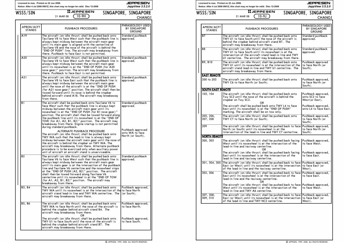
Licensed to max. Printed on 22 Jun 2008.
Notice: After 4 Jul 2008 0901Z, this chart may no longer be valid. Disc 12-2008
JEPPESEN
JeppView 3.5.2.0
SINGAPORE, SINGAPORECHANGI
WSSS/SIN JEPPESEN+
A19 The aircraft (on idle thrust) shall be pushed back onto Taxilane V8 to face West such that the pushback line is always kept midway between the aircraft main gear until its main gear is aligned with the centerline of Taxilane V8 and the nose of the aircraft is behind the "END OF PUSH" line. The aircraft may breakaway from there. Pushback to face East is not permitted.
Standard pushback approved.
A20 The aircraft (on idle thrust) shall be pushed back onto Taxilane V8 to face West such that the pushback line is always kept midway between the aircraft main gear until its nosewheel is at the "END OF PUSH (for A20 nose gear)" position. The aircraft may breakaway from there. Pushback to face East is not permitted.
Standard pushback approved.
A21 The aircraft (on idle thrust) shall be pushed back onto Taxilane V8 to face East such that the pushback line is always kept midway between the aircraft main gear until the nose of the aircraft is at the "END OF PUSH (for A21 nose gear)" position. The aircraft shall then be towed forward until its nose is behind the stopbar behind aircraft stand A18. The aircraft may breakaway from there.
Standard pushback approved.
B1 The aircraft shall be pushed back onto Taxilane V6 to face West such that the pushback line is always kept midway between the aircraft main gear until its nosewheel is at the "END OF PUSH (for B1 nose gear)" position. The aircraft shall then be towed forward along the pushback line until its nosewheel is at the "END OF TOW (for A1, A2, B1, B2)" position. The aircraft may breakaway from there. Engine startup is not permitted during standard pushback.
ALTERNATE PUSHBACK PROCEDUREThe aircraft (on idle thrust) shall be pushed back onto TWY WA such that the lead-in line is always kept midway between the aircraft main gear until the nose of the aircraft is behind the stopbar on TWY WA. The aircraft may breakaway from there. Alternate pushback procedure is to be exercised only when auxiliary power unit of aircraft at aircraft stand is unserviceable.
Standard pushback approved.
Pushback approved onto WA to face North (or South).
B2 The aircraft (on idle thrust) shall be pushed back onto Taxilane V6 to face West such that the pushback line is always kept midway between the aircraft main gear until its main gear is at the intersection of the pushback line and Taxilane V6 centerline and the nosewheel stops at the "END OF PUSH (A2, B2)" position. The aircraft shall then be towed forward along Taxilane V6 centerline until its nosewheel is at the "END OF TOW (for A1, A2, B1, B2)" position. The aircraft may breakaway from there.
Standard pushback approved.
B3, B4 The aircraft (on idle thrust) shall be pushed back onto TWY WA until its nosewheel is at the intersection of the aircraft stand lead-in line and TWY WA centerline. The aircraft may breakaway from there.
Pushback approved, to face North (or South).
B5, B6 The aircraft (on idle thrust) shall be pushed back onto TWY WA to face North until the nose of the aircraft is behind the stopbar behind aircraft stand B4. The aircraft may breakaway from there. ORThe aircraft (on idle thrust) shall be pushed back onto TWY U1 to face South until the nose of the aircraft is behind the stopbar behind aircraft stand B7. The aircraft may breakaway from there.
Pushback approved, to face North.
Pushback approved, to face South.
APRON/ACFT STANDS PUSHBACK PROCEDURES
PHRASEOLOGY USED BY SINGAPORE
GROUND
10-9H
| JEPPESEN, 1999, 2008. ALL RIGHTS RESERVED.
21 MAR 08
Licensed to max. Printed on 22 Jun 2008.
Notice: After 4 Jul 2008 0901Z, this chart may no longer be valid. Disc 12-2008
JEPPESEN
JeppView 3.5.2.0
SINGAPORE, SINGAPORECHANGI
WSSS/SIN JEPPESEN+
B7 The aircraft (on idle thrust) shall be pushed back onto TWY U1 to face South until the nose of the aircraft is behind the stopbar behind aircraft stand B7. The aircraft may breakaway from there.
Standard pushback approved.
B8 The aircraft (on idle thrust) shall be pushed back onto TWY U1 to face South until its nosewheel is at the intersection of the aircraft stand lead-in line and TWY U1 centerline. The aircraft may breakaway from there.
Standard pushback approved.
B9, B10 The aircraft (on idle thrust) shall be pushed back onto TWY U1 until its nosewheel is at the intersection of the aircraft stand lead-in line and TWY U1 centerline. The aircraft may breakaway from there.
Pushback approved to face North (or South).
EAST REMOTEEAST REMOTEEAST REMOTEEAST REMOTE
200 to 203 The aircraft (on idle thrust) shall be pushed back onto TWY C6 to face North (or South).
Pushback approved, to face North (or South).
SOUTH-EAST REMOTESOUTH-EAST REMOTESOUTH-EAST REMOTESOUTH-EAST REMOTE
103, 104 The aircraft (on idle thrust) shall be pushed back onto Twy SC2 until the nose of the aircraft is behind the stopbar on Twy SC2.
ORThe aircraft shall be pushed back onto TWY L4 to face East until its nosewheel is at the "END OF PUSH" marking. The aircraft shall be on tow only.
Pushback approved, onto SC2 to face West(or East).
Pushback approved, onto L4 to face East.
205, 206, 207, 208
The aircraft (on idle thrust) shall be pushed back onto TWY C7 to face North (or South).
Pushback approved, to face North (or South).
209 The aircraft (on idle thrust) shall be pushed back to face North (or South) until its nosewheel is at the intersection of the lead-in line and TWY C7 centerline.
Pushback approved, to face North (or South).
NORTH REMOTENORTH REMOTENORTH REMOTENORTH REMOTE
300, 303 The aircraft (on idle thrust) shall be pushed back facing West until its nosewheel is at the intersection of the lead-in line and taxiway centerline. ORThe aircraft (on idle thrust) shall be pushed back facing East until its nosewheel is at the intersection of the lead-in line and taxiway centerline.
Pushback approved, to face West.
Pushback approved, to face East.
301, 304, 305 The aircraft (on idle thrust) shall be pushed back to face East (or West) until its nosewheel is at the intersection of the lead-in line and the taxiway centerline.
Pushback approved, to face East (or West).
302, 306 The aircraft (on idle thrust) shall be pushed back to face East until its nosewheel is at the intersection of the lead-in line and the taxiway centerline.
ORThe aircraft (on idle thrust) shall be pushed back to face West until its nosewheel is at the intersection of the lead-in line and TWY A6 centerline.
Pushback approved, to face East.
Pushback approved, to face West.
307, 308, 309, 310
The aircraft (on idle thrust) shall be pushed back to face East (or West) until its nosewheel is at the intersection of the lead-in line and TWY NC2 centerline.
Pushback approved, to face East (or West).
APRON/ACFT STANDS PUSHBACK PROCEDURES
PHRASEOLOGY USED BY SINGAPORE
GROUND
10-9J
| JEPPESEN, 1999, 2008. ALL RIGHTS RESERVED.
21 MAR 08
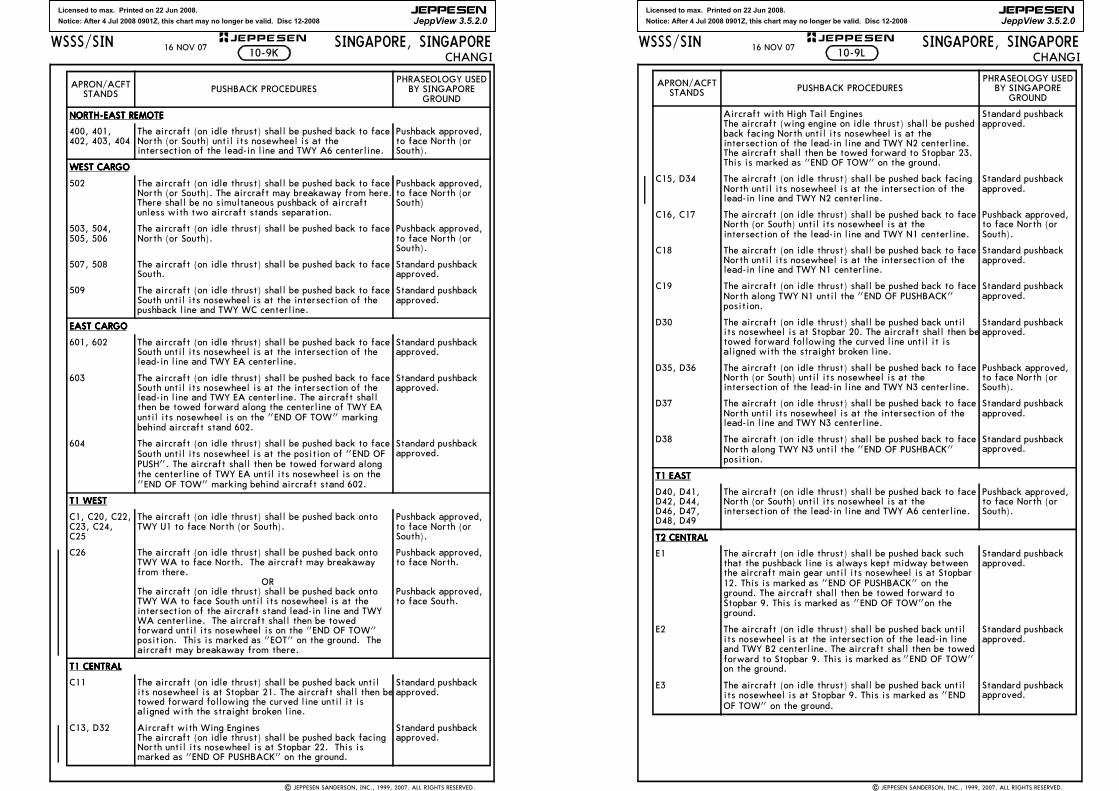
Licensed to max. Printed on 22 Jun 2008.
Notice: After 4 Jul 2008 0901Z, this chart may no longer be valid. Disc 12-2008
JEPPESEN
JeppView 3.5.2.0
SINGAPORE, SINGAPORECHANGI
WSSS/SIN JEPPESEN+
NORTH-EAST REMOTENORTH-EAST REMOTENORTH-EAST REMOTENORTH-EAST REMOTE
400, 401, 402, 403, 404
The aircraft (on idle thrust) shall be pushed back to face North (or South) until its nosewheel is at the intersection of the lead-in line and TWY A6 centerline.
Pushback approved, to face North (or South).
WEST CARGOWEST CARGOWEST CARGOWEST CARGO
502 The aircraft (on idle thrust) shall be pushed back to face North (or South). The aircraft may breakaway from here. There shall be no simultaneous pushback of aircraft unless with two aircraft stands separation.
Pushback approved, to face North (or South)
503, 504, 505, 506
The aircraft (on idle thrust) shall be pushed back to face North (or South).
Pushback approved, to face North (or South).
507, 508 The aircraft (on idle thrust) shall be pushed back to face South.
Standard pushback approved.
509 The aircraft (on idle thrust) shall be pushed back to face South until its nosewheel is at the intersection of the pushback line and TWY WC centerline.
Standard pushback approved.
EAST CARGOEAST CARGOEAST CARGOEAST CARGO
601, 602 The aircraft (on idle thrust) shall be pushed back to face South until its nosewheel is at the intersection of the lead-in line and TWY EA centerline.
Standard pushback approved.
603 The aircraft (on idle thrust) shall be pushed back to face South until its nosewheel is at the intersection of the lead-in line and TWY EA centerline. The aircraft shall then be towed forward along the centerline of TWY EA until its nosewheel is on the "END OF TOW" marking behind aircraft stand 602.
Standard pushback approved.
604 The aircraft (on idle thrust) shall be pushed back to face South until its nosewheel is at the position of "END OF PUSH". The aircraft shall then be towed forward along the centerline of TWY EA until its nosewheel is on the "END OF TOW" marking behind aircraft stand 602.
Standard pushback approved.
T1 WESTT1 WESTT1 WESTT1 WEST
C1, C20, C22, C23, C24, C25
The aircraft (on idle thrust) shall be pushed back onto TWY U1 to face North (or South).
Pushback approved, to face North (or South).
C26 The aircraft (on idle thrust) shall be pushed back onto TWY WA to face North. The aircraft may breakaway from there. ORThe aircraft (on idle thrust) shall be pushed back onto TWY WA to face South until its nosewheel is at the intersection of the aircraft stand lead-in line and TWY WA centerline. The aircraft shall then be towed forward until its nosewheel is on the "END OF TOW" position. This is marked as "EOT" on the ground. The aircraft may breakaway from there.
Pushback approved, to face North.
Pushback approved, to face South.
T1 CENTRALT1 CENTRALT1 CENTRALT1 CENTRAL
C11 The aircraft (on idle thrust) shall be pushed back until its nosewheel is at Stopbar 21. The aircraft shall then be towed forward following the curved line until it is aligned with the straight broken line.
Standard pushback approved.
C13, D32 Aircraft with Wing EnginesThe aircraft (on idle thrust) shall be pushed back facing North until its nosewheel is at Stopbar 22. This is marked as "END OF PUSHBACK" on the ground.
Standard pushback approved.
APRON/ACFT STANDS PUSHBACK PROCEDURES
PHRASEOLOGY USED BY SINGAPORE
GROUND
10-9K
| JEPPESEN SANDERSON, INC., 1999, 2007. ALL RIGHTS RESERVED.
16 NOV 07
Licensed to max. Printed on 22 Jun 2008.
Notice: After 4 Jul 2008 0901Z, this chart may no longer be valid. Disc 12-2008
JEPPESEN
JeppView 3.5.2.0
SINGAPORE, SINGAPORECHANGI
WSSS/SIN JEPPESEN+
Aircraft with High Tail EnginesThe aircraft (wing engine on idle thrust) shall be pushed back facing North until its nosewheel is at the intersection of the lead-in line and TWY N2 centerline. The aircraft shall then be towed forward to Stopbar 23. This is marked as "END OF TOW" on the ground.
Standard pushback approved.
C15, D34 The aircraft (on idle thrust) shall be pushed back facing North until its nosewheel is at the intersection of the lead-in line and TWY N2 centerline.
Standard pushback approved.
C16, C17 The aircraft (on idle thrust) shall be pushed back to face North (or South) until its nosewheel is at the intersection of the lead-in line and TWY N1 centerline.
Pushback approved, to face North (or South).
C18 The aircraft (on idle thrust) shall be pushed back to face North until its nosewheel is at the intersection of the lead-in line and TWY N1 centerline.
Standard pushback approved.
C19 The aircraft (on idle thrust) shall be pushed back to face North along TWY N1 until the "END OF PUSHBACK" position.
Standard pushback approved.
D30 The aircraft (on idle thrust) shall be pushed back until its nosewheel is at Stopbar 20. The aircraft shall then be towed forward following the curved line until it is aligned with the straight broken line.
Standard pushback approved.
D35, D36 The aircraft (on idle thrust) shall be pushed back to face North (or South) until its nosewheel is at the intersection of the lead-in line and TWY N3 centerline.
Pushback approved, to face North (or South).
D37 The aircraft (on idle thrust) shall be pushed back to face North until its nosewheel is at the intersection of the lead-in line and TWY N3 centerline.
Standard pushback approved.
D38 The aircraft (on idle thrust) shall be pushed back to face North along TWY N3 until the "END OF PUSHBACK" position.
Standard pushback approved.
T1 EASTT1 EASTT1 EASTT1 EAST
D40, D41, D42, D44, D46, D47, D48, D49
The aircraft (on idle thrust) shall be pushed back to face North (or South) until its nosewheel is at the intersection of the lead-in line and TWY A6 centerline.
Pushback approved, to face North (or South).
T2 CENTRALT2 CENTRALT2 CENTRALT2 CENTRAL
E1 The aircraft (on idle thrust) shall be pushed back such that the pushback line is always kept midway between the aircraft main gear until its nosewheel is at Stopbar 12. This is marked as "END OF PUSHBACK" on the ground. The aircraft shall then be towed forward to Stopbar 9. This is marked as "END OF TOW"on the ground.
Standard pushback approved.
E2 The aircraft (on idle thrust) shall be pushed back until its nosewheel is at the intersection of the lead-in line and TWY B2 centerline. The aircraft shall then be towed forward to Stopbar 9. This is marked as "END OF TOW" on the ground.
Standard pushback approved.
E3 The aircraft (on idle thrust) shall be pushed back until its nosewheel is at Stopbar 9. This is marked as "END OF TOW" on the ground.
Standard pushback approved.
APRON/ACFT STANDS PUSHBACK PROCEDURES
PHRASEOLOGY USED BY SINGAPORE
GROUND
10-9L
| JEPPESEN SANDERSON, INC., 1999, 2007. ALL RIGHTS RESERVED.
16 NOV 07
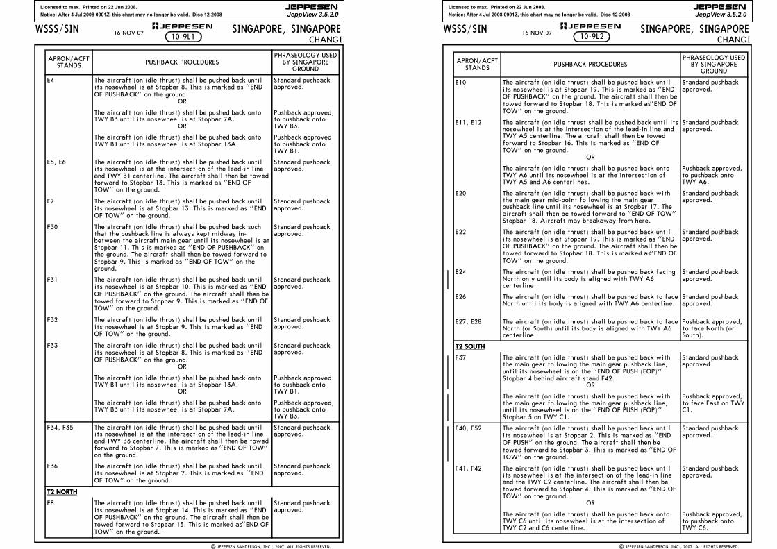
Licensed to max. Printed on 22 Jun 2008.
Notice: After 4 Jul 2008 0901Z, this chart may no longer be valid. Disc 12-2008
JEPPESEN
JeppView 3.5.2.0
SINGAPORE, SINGAPORECHANGI
WSSS/SIN JEPPESEN+
E4 The aircraft (on idle thrust) shall be pushed back until its nosewheel is at Stopbar 8. This is marked as "END OF PUSHBACK" on the ground.
OR
Standard pushback approved.
The aircraft (on idle thrust) shall be pushed back onto TWY B3 until its nosewheel is at Stopbar 7A.
OR
Pushback approved, to pushback onto TWY B3.
The aircraft (on idle thrust) shall be pushed back onto TWY B1 until its nosewheel is at Stopbar 13A.
Pushback approved to pushback onto TWY B1.
E5, E6 The aircraft (on idle thrust) shall be pushed back until its nosewheel is at the intersection of the lead-in line and TWY B1 centerline. The aircraft shall then be towed forward to Stopbar 13. This is marked as "END OF TOW" on the ground.
Standard pushback approved.
E7 The aircraft (on idle thrust) shall be pushed back until its nosewheel is at Stopbar 13. This is marked as "END OF TOW" on the ground.
Standard pushback approved.
F30 The aircraft (on idle thrust) shall be pushed back such that the pushback line is always kept midway in-between the aircraft main gear until its nosewheel is at Stopbar 11. This is marked as "END OF PUSHBACK" on the ground. The aircraft shall then be towed forward to Stopbar 9. This is marked as "END OF TOW" on the ground.
Standard pushback approved.
F31 The aircraft (on idle thrust) shall be pushed back until its nosewheel is at Stopbar 10. This is marked as "END OF PUSHBACK" on the ground. The aircraft shall then be towed forward to Stopbar 9. This is marked as "END OF TOW" on the ground.
Standard pushback approved.
F32 The aircraft (on idle thrust) shall be pushed back until its nosewheel is at Stopbar 9. This is marked as "END OF TOW" on the ground.
Standard pushback approved.
F33 The aircraft (on idle thrust) shall be pushed back until its nosewheel is at Stopbar 8. This is marked as "END OF PUSHBACK" on the ground.
OR
Standard pushback approved.
The aircraft (on idle thrust) shall be pushed back onto TWY B1 until its nosewheel is at Stopbar 13A.
OR
Pushback approved to pushback onto TWY B1.
The aircraft (on idle thrust) shall be pushed back onto TWY B3 until its nosewheel is at Stopbar 7A.
Pushback approved, to pushback onto TWY B3.
F34, F35 The aircraft (on idle thrust) shall be pushed back until its nosewheel is at the intersection of the lead-in line and TWY B3 centerline. The aircraft shall then be towed forward to Stopbar 7. This is marked as "END OF TOW" on the ground.
Standard pushback approved.
F36 The aircraft (on idle thrust) shall be pushed back until its nosewheel is at Stopbar 7. This is marked as '’END OF TOW" on the ground.
Standard pushback approved.
T2 NORTHT2 NORTHT2 NORTHT2 NORTH
E8 The aircraft (on idle thrust) shall be pushed back until its nosewheel is at Stopbar 14. This is marked as "END OF PUSHBACK" on the ground. The aircraft shall then be towed forward to Stopbar 15. This is marked as "END OF TOW" on the ground.
Standard pushback approved.
APRON/ACFT STANDS PUSHBACK PROCEDURES
PHRASEOLOGY USED BY SINGAPORE
GROUND
10-9L1
| JEPPESEN SANDERSON, INC., 2007. ALL RIGHTS RESERVED.
16 NOV 07
Licensed to max. Printed on 22 Jun 2008.
Notice: After 4 Jul 2008 0901Z, this chart may no longer be valid. Disc 12-2008
JEPPESEN
JeppView 3.5.2.0
SINGAPORE, SINGAPORECHANGI
WSSS/SIN JEPPESEN+
E10 The aircraft (on idle thrust) shall be pushed back until its nosewheel is at Stopbar 19. This is marked as "END OF PUSHBACK" on the ground. The aircraft shall then be towed forward to Stopbar 18. This is marked as "END OF TOW" on the ground.
Standard pushback approved.
E11, E12 The aircraft (on idle thrust shall be pushed back until its nosewheel is at the intersection of the lead-in line and TWY A5 centerline. The aircraft shall then be towed forward to Stopbar 16. This is marked as "END OF TOW" on the ground.
OR
Standard pushback approved.
The aircraft (on idle thrust) shall be pushed back onto TWY A6 until its nosewheel is at the intersection of TWY A5 and A6 centerlines.
Pushback approved, to pushback onto TWY A6.
E20 The aircraft (on idle thrust) shall be pushed back with the main gear mid-point following the main gear pushback line until its nosewheel is at Stopbar 17. The aircraft shall then be towed forward to "END OF TOW" Stopbar 18. Aircraft may breakaway from here.
Standard pushback approved.
E22 The aircraft (on idle thrust) shall be pushed back until its nosewheel is at Stopbar 19. This is marked as "END OF PUSHBACK" on the ground. The aircraft shall then be towed forward to Stopbar 18. This is marked as "END OF TOW" on the ground.
Standard pushback approved.
E24 The aircraft (on idle thrust) shall be pushed back facing North only until its body is aligned with TWY A6 centerline.
Standard pushback approved.
E26 The aircraft (on idle thrust) shall be pushed back to face North until its body is aligned with TWY A6 centerline.
Standard pushback approved.
E27, E28 The aircraft (on idle thrust) shall be pushed back to face North (or South) until its body is aligned with TWY A6 centerline.
Pushback approved, to face North (or South).
T2 SOUTHT2 SOUTHT2 SOUTHT2 SOUTH
F37 The aircraft (on idle thrust) shall be pushed back with the main gear following the main gear pushback line, until its nosewheel is on the "END OF PUSH (EOP)" Stopbar 4 behind aircraft stand F42.
OR
Standard pushback approved
The aircraft (on idle thrust) shall be pushed back with the main gear following the main gear pushback line, until its nosewheel is on the "END OF PUSH (EOP)" Stopbar 5 on TWY C1.
Pushback approved, to face East on TWY C1.
F40, F52 The aircraft (on idle thrust) shall be pushed back until its nosewheel is at Stopbar 2. This is marked as "END OF PUSH" on the ground. The aircraft shall then be towed forward to Stopbar 3. This is marked as "END OF TOW" on the ground.
Standard pushback approved.
F41, F42 The aircraft (on idle thrust) shall be pushed back until its nosewheel is at the intersection of the lead-in line and the TWY C2 centerline. The aircraft shall then be towed forward to Stopbar 4. This is marked as "END OF TOW" on the ground.
OR
Standard pushback approved.
The aircraft (on idle thrust) shall be pushed back onto TWY C6 until its nosewheel is at the intersection of TWY C2 and C6 centerline.
Pushback approved, to pushback onto TWY C6.
APRON/ACFT STANDS PUSHBACK PROCEDURES
PHRASEOLOGY USED BY SINGAPORE
GROUND
| JEPPESEN SANDERSON, INC., 2007. ALL RIGHTS RESERVED.
10-9L216 NOV 07
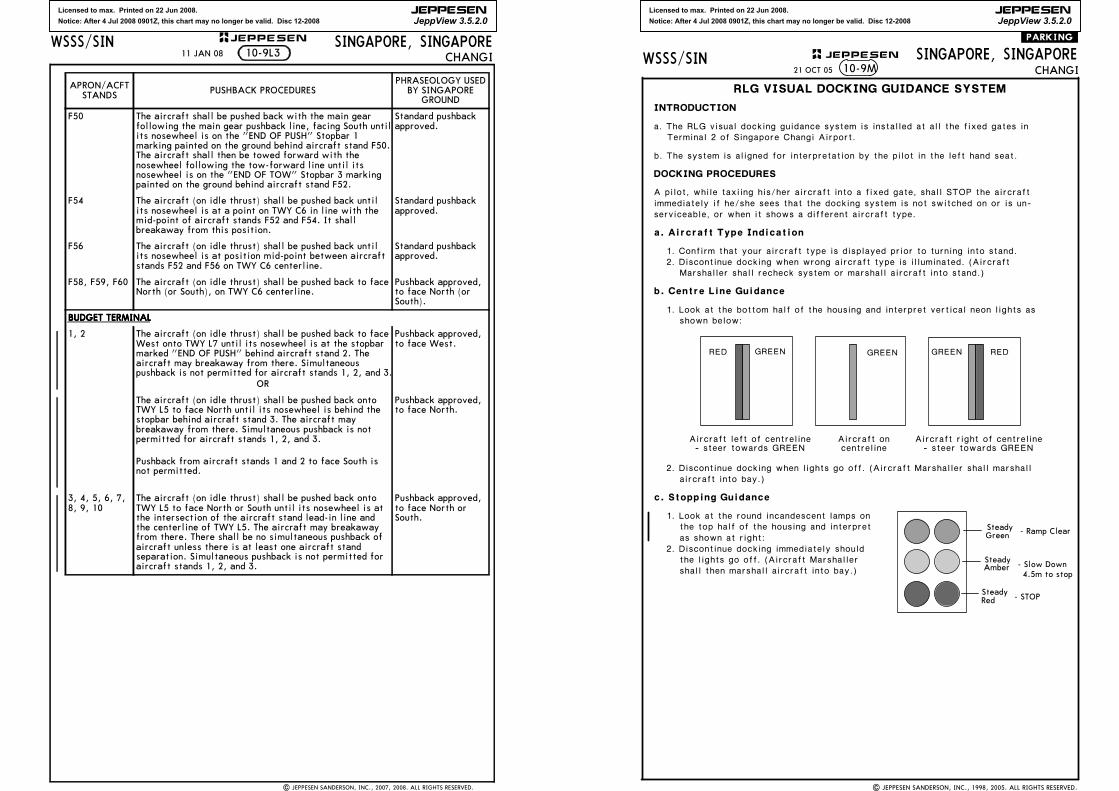
Licensed to max. Printed on 22 Jun 2008.
Notice: After 4 Jul 2008 0901Z, this chart may no longer be valid. Disc 12-2008
JEPPESEN
JeppView 3.5.2.0
SINGAPORE, SINGAPORECHANGI
WSSS/SIN JEPPESEN+
F50 The aircraft shall be pushed back with the main gear following the main gear pushback line, facing South until its nosewheel is on the "END OF PUSH" Stopbar 1 marking painted on the ground behind aircraft stand F50. The aircraft shall then be towed forward with the nosewheel following the tow-forward line until its nosewheel is on the "END OF TOW" Stopbar 3 marking painted on the ground behind aircraft stand F52.
Standard pushback approved.
F54 The aircraft (on idle thrust) shall be pushed back until its nosewheel is at a point on TWY C6 in line with the mid-point of aircraft stands F52 and F54. It shall breakaway from this position.
Standard pushback approved.
F56 The aircraft (on idle thrust) shall be pushed back until its nosewheel is at position mid-point between aircraft stands F52 and F56 on TWY C6 centerline.
Standard pushback approved.
F58, F59, F60 The aircraft (on idle thrust) shall be pushed back to face North (or South), on TWY C6 centerline.
Pushback approved, to face North (or South).
BUDGET TERMINALBUDGET TERMINALBUDGET TERMINALBUDGET TERMINAL
1, 2 The aircraft (on idle thrust) shall be pushed back to face West onto TWY L7 until its nosewheel is at the stopbar marked "END OF PUSH" behind aircraft stand 2. The aircraft may breakaway from there. Simultaneous pushback is not permitted for aircraft stands 1, 2, and 3.
OR
Pushback approved, to face West.
The aircraft (on idle thrust) shall be pushed back onto TWY L5 to face North until its nosewheel is behind the stopbar behind aircraft stand 3. The aircraft may breakaway from there. Simultaneous pushback is not permitted for aircraft stands 1, 2, and 3.
Pushback from aircraft stands 1 and 2 to face South is not permitted.
Pushback approved, to face North.
3, 4, 5, 6, 7, 8, 9, 10
The aircraft (on idle thrust) shall be pushed back onto TWY L5 to face North or South until its nosewheel is at the intersection of the aircraft stand lead-in line and the centerline of TWY L5. The aircraft may breakaway from there. There shall be no simultaneous pushback of aircraft unless there is at least one aircraft stand separation. Simultaneous pushback is not permitted for aircraft stands 1, 2, and 3.
Pushback approved, to face North or South.
APRON/ACFT STANDS PUSHBACK PROCEDURES
PHRASEOLOGY USED BY SINGAPORE
GROUND
10-9L3
| JEPPESEN SANDERSON, INC., 2007, 2008. ALL RIGHTS RESERVED.
11 JAN 08
Licensed to max. Printed on 22 Jun 2008.
Notice: After 4 Jul 2008 0901Z, this chart may no longer be valid. Disc 12-2008
JEPPESEN
JeppView 3.5.2.0
WSSS/SIN JEPPESEN
21 OCT 05 10-9M
| JEPPESEN SANDERSON, INC., 1998, 2005. ALL RIGHTS RESERVED.
SINGAPORE, SINGAPORECHANGI
.PARKING.
INTRODUCTION
b. The system is aligned for interpretation by the pilot in the left hand seat.
DOCKING PROCEDURES
A pilot, while taxiing his/her aircraft into a fixed gate, shall STOP the aircraft immediately if he/she sees that the docking system is not switched on or is un-serviceable, or when it shows a different aircraft type.
a. Aircraft Type Indication
1. Confirm that your aircraft type is displayed prior to turning into stand.2. Discontinue docking when wrong aircraft type is illuminated. (Aircraft
Marshaller shall recheck system or marshall aircraft into stand.)
b. Centre Line Guidance
1. Look at the bottom half of the housing and interpret vertical neon lights as shown below:
aircraft into bay.)
c. Stopping Guidance
1. Look at the round incandescent lamps on the top half of the housing and interpret as shown at right:
2. Discontinue docking immediately should the lights go off. (Aircraft Marshaller shall then marshall aircraft into bay.)
RLG VISUAL DOCKING GUIDANCE SYSTEM
a. The RLG visual docking guidance system is installed at all the fixed gates in Terminal 2 of Singapore Changi Airport.
2. Discontinue docking when lights go off. (Aircraft Marshaller shall marshall
RED GREEN GREEN GREEN RED
SteadyGreen - Ramp Clear
SteadyAmber - Slow Down
4.5m to stop
SteadyRed - STOP
Aircraft left of centreline- steer towards GREEN
Aircraft oncentreline
Aircraft right of centreline- steer towards GREEN
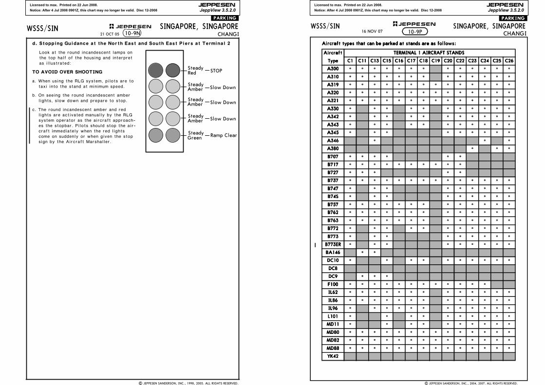
Licensed to max. Printed on 22 Jun 2008.
Notice: After 4 Jul 2008 0901Z, this chart may no longer be valid. Disc 12-2008
JEPPESEN
JeppView 3.5.2.0
WSSS/SIN JEPPESEN
21 OCT 05 10-9N
| JEPPESEN SANDERSON, INC., 1998, 2005. ALL RIGHTS RESERVED.
SINGAPORE, SINGAPORECHANGI
.PARKING.
d. Stopping Guidance at the North East and South East Piers at Terminal 2
Look at the round incandescent lamps on the top half of the housing and interpret as illustrated:
TO AVOID OVER SHOOTING
a. When using the RLG system, pilots are to taxi into the stand at minimum speed.
lights, slow down and prepare to stop.b. On seeing the round incandescent amber
c. The round incandescent amber and red lights are activated manually by the RLG system operator as the aircraft approach-es the stopbar. Pilots should stop the air-craft immediately when the red lights come on suddenly or when given the stop sign by the Aircraft Marshaller.
SteadyRed
Steady
Steady
Steady
Steady
Amber
Amber
Amber
Green
STOP
Slow Down
Slow Down
Slow Down
Ramp Clear
Licensed to max. Printed on 22 Jun 2008.
Notice: After 4 Jul 2008 0901Z, this chart may no longer be valid. Disc 12-2008
JEPPESEN
JeppView 3.5.2.0
| JEPPESEN SANDERSON, INC., 2004, 2007. ALL RIGHTS RESERVED.
SINGAPORE, SINGAPORECHANGI
WSSS/SIN JEPPESEN+.PARKING.
10-9P
Aircraft types that can be parked at stands are as follows:Aircraft types that can be parked at stands are as follows:Aircraft types that can be parked at stands are as follows:Aircraft types that can be parked at stands are as follows:
AircraftAircraftAircraftAircraft TERMINAL 1 AIRCRAFT STANDSTERMINAL 1 AIRCRAFT STANDSTERMINAL 1 AIRCRAFT STANDSTERMINAL 1 AIRCRAFT STANDS
TypeTypeTypeType C1C1C1C1 C11C11C11C11 C13C13C13C13 C15C15C15C15 C16C16C16C16 C17C17C17C17 C18C18C18C18 C19C19C19C19 C20C20C20C20 C22C22C22C22 C23C23C23C23 C24C24C24C24 C25C25C25C25 C26C26C26C26
A300A300A300A300 ^ ^ ^ ^ ^ ^ ^ ^ ^ ^ ^ ^ ^
A310A310A310A310 ^ ^ ^ ^ ^ ^ ^ ^ ^ ^ ^ ^ ^
A319A319A319A319 ^ ^ ^ ^ ^ ^ ^ ^ ^ ^ ^ ^ ^ ^
A320A320A320A320 ^ ^ ^ ^ ^ ^ ^ ^ ^ ^ ^ ^ ^ ^
A321A321A321A321 ^ ^ ^ ^ ^ ^ ^ ^ ^ ^ ^ ^ ^ ^
A330A330A330A330 ^ ^ ^ ^ ^ ^ ^ ^ ^ ^ ^
A342A342A342A342 ^ ^ ^ ^ ^ ^ ^ ^ ^ ^ ^
A343A343A343A343 ^ ^ ^ ^ ^ ^ ^ ^ ^ ^ ^
A345A345A345A345 ^ ^ ^ ^ ^ ^ ^ ^ ^
A346A346A346A346 ^ ^ ^
A380A380A380A380 ^ ^ ^
B707B707B707B707 ^ ^ ^ ^ ^ ^
B717B717B717B717 ^ ^ ^ ^ ^ ^ ^ ^ ^ ^
B727B727B727B727 ^ ^ ^ ^ ^
B737B737B737B737 ^ ^ ^ ^ ^ ^ ^ ^ ^ ^ ^ ^ ^ ^
B747B747B747B747 ^ ^ ^ ^ ^ ^ ^ ^ ^
B74SB74SB74SB74S ^ ^ ^ ^ ^ ^ ^ ^ ^
B757B757B757B757 ^ ^ ^ ^ ^ ^ ^ ^ ^ ^ ^ ^ ^
B762B762B762B762 ^ ^ ^ ^ ^ ^ ^ ^ ^ ^ ^ ^ ^
B763B763B763B763 ^ ^ ^ ^ ^ ^ ^ ^ ^ ^ ^ ^ ^
B772B772B772B772 ^ ^ ^ ^ ^ ^ ^ ^ ^ ^ ^
B773B773B773B773 ^ ^ ^ ^ ^ ^ ^ ^ ^
B773ERB773ERB773ERB773ER ^ ^ ^ ^ ^ ^ ^ ^ ^
BA146BA146BA146BA146 ^ ^
DC10DC10DC10DC10 ^ ^ ^ ^ ^ ^ ^ ^ ^ ^
DC8DC8DC8DC8
DC9DC9DC9DC9 ^ ^ ^
F100F100F100F100 ^ ^ ^ ^ ^ ^ ^ ^ ^ ^ ^ ^
IL62IL62IL62IL62 ^ ^ ^ ^ ^ ^ ^ ^ ^ ^ ^ ^ ^
IL86IL86IL86IL86 ^ ^ ^ ^ ^ ^ ^ ^ ^ ^ ^ ^ ^
IL96IL96IL96IL96 ^ ^ ^ ^ ^ ^ ^ ^ ^ ^ ^ ^
L101L101L101L101 ^ ^ ^ ^ ^ ^ ^ ^ ^ ^
MD11MD11MD11MD11 ^ ^ ^ ^ ^ ^ ^ ^ ^ ^
MD80MD80MD80MD80 ^ ^ ^ ^ ^ ^ ^ ^ ^ ^ ^ ^ ^ ^
MD82MD82MD82MD82 ^ ^ ^ ^ ^ ^ ^ ^ ^ ^ ^ ^ ^ ^
MD88MD88MD88MD88 ^ ^ ^ ^ ^ ^ ^ ^ ^ ^ ^ ^ ^ ^
YK42YK42YK42YK42
16 NOV 07
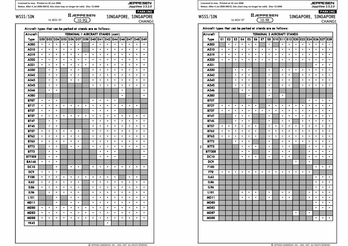
Licensed to max. Printed on 22 Jun 2008.
Notice: After 4 Jul 2008 0901Z, this chart may no longer be valid. Disc 12-2008
JEPPESEN
JeppView 3.5.2.0
| JEPPESEN SANDERSON, INC., 2004, 2007. ALL RIGHTS RESERVED.
SINGAPORE, SINGAPORECHANGI
WSSS/SIN JEPPESEN+.PARKING.
Aircraft types that can be parked at stands are as follows: Aircraft types that can be parked at stands are as follows: Aircraft types that can be parked at stands are as follows: Aircraft types that can be parked at stands are as follows:
AircraftAircraftAircraftAircraft TERMINAL 1 AIRCRAFT STANDS (cont)TERMINAL 1 AIRCRAFT STANDS (cont)TERMINAL 1 AIRCRAFT STANDS (cont)TERMINAL 1 AIRCRAFT STANDS (cont)
TypeTypeTypeType D30D30D30D30 D32D32D32D32 D34D34D34D34 D35D35D35D35 D36D36D36D36 D37D37D37D37 D38D38D38D38 D40D40D40D40 D41D41D41D41 D42D42D42D42 D44D44D44D44 D46D46D46D46 D47D47D47D47 D48D48D48D48 D49D49D49D49
A300A300A300A300 ^ ^ ^ ^ ^ ^ ^ ^ ^ ^ ^ ^ ^ ^
A310A310A310A310 ^ ^ ^ ^ ^ ^ ^ ^ ^ ^ ^ ^ ^ ^
A319A319A319A319 ^ ^ ^ ^ ^ ^ ^ ^ ^ ^ ^ ^ ^ ^ ^
A320A320A320A320 ^ ^ ^ ^ ^ ^ ^ ^ ^ ^ ^ ^ ^ ^ ^
A321A321A321A321 ^ ^ ^ ^ ^ ^ ^ ^ ^ ^ ^ ^ ^ ^ ^
A330A330A330A330 ^ ^ ^ ^ ^ ^ ^ ^ ^ ^ ^ ^
A342A342A342A342 ^ ^ ^ ^ ^ ^ ^ ^ ^ ^ ^ ^
A343A343A343A343 ^ ^ ^ ^ ^ ^ ^ ^ ^ ^ ^ ^
A345A345A345A345 ^ ^ ^ ^ ^ ^ ^ ^ ^ ^
A346A346A346A346 ^ ^ ^ ^
A380A380A380A380 ^ ^
B707B707B707B707 ^ ^ ^ ^ ^ ^ ^
B717B717B717B717 ^ ^ ^ ^ ^ ^ ^ ^ ^ ^ ^ ^ ^ ^
B727B727B727B727 ^ ^ ^ ^ ^ ^ ^
B737B737B737B737 ^ ^ ^ ^ ^ ^ ^ ^ ^ ^ ^ ^ ^ ^ ^
B747B747B747B747 ^ ^ ^ ^ ^ ^ ^ ^ ^ ^
B74SB74SB74SB74S ^ ^ ^ ^ ^ ^ ^ ^ ^ ^
B757B757B757B757 ^ ^ ^ ^ ^ ^ ^ ^ ^ ^ ^ ^ ^ ^
B762B762B762B762 ^ ^ ^ ^ ^ ^ ^ ^ ^ ^ ^ ^ ^ ^
B763B763B763B763 ^ ^ ^ ^ ^ ^ ^ ^ ^ ^ ^ ^ ^ ^
B772B772B772B772 ^ ^ ^ ^ ^ ^ ^ ^ ^ ^ ^ ^
B773B773B773B773 ^ ^ ^ ^ ^ ^
B773ERB773ERB773ERB773ER ^ ^ ^ ^ ^ ^
BA146BA146BA146BA146 ^ ^ ^
DC10DC10DC10DC10 ^ ^ ^ ^ ^ ^ ^ ^ ^ ^ ^
DC9DC9DC9DC9 ^ ^ ^
F100F100F100F100 ^ ^ ^ ^ ^ ^ ^ ^ ^ ^ ^ ^ ^
IL62IL62IL62IL62 ^ ^ ^ ^ ^ ^ ^ ^ ^ ^ ^ ^ ^ ^
IL86IL86IL86IL86 ^ ^ ^ ^ ^ ^ ^ ^ ^ ^ ^ ^ ^ ^
IL96IL96IL96IL96 ^ ^ ^ ^ ^ ^ ^ ^ ^ ^ ^ ^ ^
L101L101L101L101 ^ ^ ^ ^ ^ ^ ^ ^ ^ ^ ^
MD11MD11MD11MD11 ^ ^ ^ ^ ^ ^ ^ ^ ^ ^ ^
MD80MD80MD80MD80 ^ ^ ^ ^ ^ ^ ^ ^ ^ ^ ^ ^ ^ ^ ^
MD82MD82MD82MD82 ^ ^ ^ ^ ^ ^ ^ ^ ^ ^ ^ ^ ^ ^ ^
MD88MD88MD88MD88 ^ ^ ^ ^ ^ ^ ^ ^ ^ ^ ^ ^ ^ ^ ^
YK42YK42YK42YK42 ^
10-9Q16 NOV 07
Licensed to max. Printed on 22 Jun 2008.
Notice: After 4 Jul 2008 0901Z, this chart may no longer be valid. Disc 12-2008
JEPPESEN
JeppView 3.5.2.0
| JEPPESEN SANDERSON, INC., 2004, 2007. ALL RIGHTS RESERVED.
SINGAPORE, SINGAPORECHANGI
WSSS/SIN JEPPESEN+.PARKING.
Aircraft types that can be parked at stands are as follows:Aircraft types that can be parked at stands are as follows:Aircraft types that can be parked at stands are as follows:Aircraft types that can be parked at stands are as follows:
AircraftAircraftAircraftAircraft TERMINAL 2 AIRCRAFT STANDSTERMINAL 2 AIRCRAFT STANDSTERMINAL 2 AIRCRAFT STANDSTERMINAL 2 AIRCRAFT STANDS
TypeTypeTypeType E1E1E1E1 E2E2E2E2 E3E3E3E3 E4E4E4E4 E5E5E5E5 E6E6E6E6 E7E7E7E7 E8E8E8E8 E10E10E10E10 E11E11E11E11 E12E12E12E12 E20E20E20E20 E22E22E22E22 E24E24E24E24 E26E26E26E26 E27E27E27E27 E28E28E28E28
A300A300A300A300 ^ ^ ^ ^ ^ ^ ^ ^ ^ ^ ^ ^ ^ ^
A310A310A310A310 ^ ^ ^ ^ ^ ^ ^ ^ ^ ^ ^ ^ ^ ^ ^ ^ ^
A319A319A319A319 ^ ^ ^ ^ ^ ^ ^ ^ ^ ^ ^ ^ ^ ^ ^ ^ ^
A320A320A320A320 ^ ^ ^ ^ ^ ^ ^ ^ ^ ^ ^ ^ ^ ^ ^ ^ ^
A321A321A321A321 ^ ^ ^
A330A330A330A330 ^ ^ ^ ^ ^ ^ ^ ^ ^ ^ ^ ^
A342A342A342A342 ^ ^ ^ ^ ^ ^ ^ ^ ^ ^ ^
A343A343A343A343 ^ ^ ^ ^ ^ ^ ^ ^ ^ ^ ^
A345A345A345A345 ^ ^ ^ ^ ^ ^ ^ ^ ^ ^ ^
A346A346A346A346 ^ ^ ^
A380A380A380A380 ^ ^ ^
B707B707B707B707 ^ ^ ^ ^
B727B727B727B727 ^ ^ ^ ^ ^ ^ ^ ^ ^ ^ ^ ^ ^ ^ ^ ^
B737B737B737B737 ^ ^ ^ ^ ^ ^ ^ ^ ^ ^ ^ ^ ^ ^ ^ ^ ^
B747B747B747B747 ^ ^ ^ ^ ^ ^ ^ ^ ^ ^ ^ ^
B74SB74SB74SB74S ^ ^ ^ ^ ^ ^ ^ ^ ^ ^ ^
B757B757B757B757 ^ ^ ^ ^ ^ ^ ^ ^ ^ ^ ^ ^ ^ ^ ^ ^
B762B762B762B762 ^ ^ ^ ^ ^ ^ ^ ^ ^ ^ ^ ^ ^ ^ ^ ^
B763B763B763B763 ^ ^ ^ ^ ^ ^ ^ ^ ^ ^ ^ ^ ^ ^ ^ ^
B772B772B772B772 ^ ^ ^ ^ ^ ^ ^ ^ ^ ^ ^ ^
B773B773B773B773 ^ ^ ^ ^ ^ ^ ^ ^ ^ ^
B773ERB773ERB773ERB773ER ^ ^ ^ ^ ^ ^ ^ ^ ^
DC10DC10DC10DC10 ^ ^ ^ ^ ^ ^ ^ ^ ^ ^
DC9DC9DC9DC9 ^ ^
F100F100F100F100 ^ ^ ^
F70F70F70F70 ^ ^ ^ ^ ^ ^ ^ ^ ^ ^ ^ ^ ^ ^
IL62IL62IL62IL62 ^ ^ ^
IL86IL86IL86IL86 ^ ^ ^
IL96IL96IL96IL96 ^ ^ ^
L101L101L101L101 ^ ^ ^ ^ ^ ^ ^ ^ ^ ^
MD11MD11MD11MD11 ^ ^ ^ ^ ^ ^ ^ ^ ^ ^
MD80MD80MD80MD80 ^ ^ ^
MD82MD82MD82MD82 ^ ^ ^
MD87MD87MD87MD87 ^ ^
MD88MD88MD88MD88 ^ ^ ^
10-9R16 NOV 07
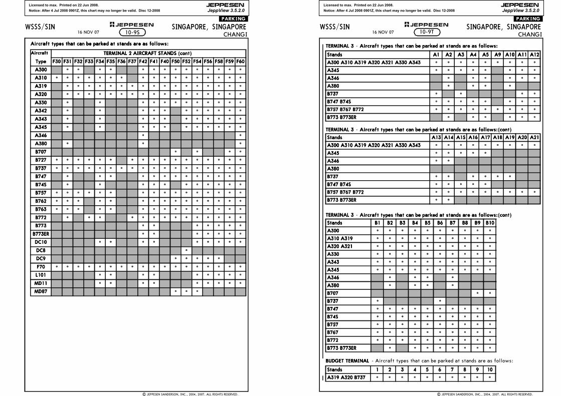
Licensed to max. Printed on 22 Jun 2008.
Notice: After 4 Jul 2008 0901Z, this chart may no longer be valid. Disc 12-2008
JEPPESEN
JeppView 3.5.2.0
| JEPPESEN SANDERSON, INC., 2004, 2007. ALL RIGHTS RESERVED.
SINGAPORE, SINGAPORECHANGI
WSSS/SIN JEPPESEN+.PARKING.
Aircraft types that can be parked at stands are as follows:Aircraft types that can be parked at stands are as follows:Aircraft types that can be parked at stands are as follows:Aircraft types that can be parked at stands are as follows:
AircraftAircraftAircraftAircraft TERMINAL 2 AIRCRAFT STANDS (cont)TERMINAL 2 AIRCRAFT STANDS (cont)TERMINAL 2 AIRCRAFT STANDS (cont)TERMINAL 2 AIRCRAFT STANDS (cont)
TypeTypeTypeType F30F30F30F30 F31F31F31F31 F32F32F32F32 F33F33F33F33 F34F34F34F34 F35F35F35F35 F36F36F36F36 F37F37F37F37 F42F42F42F42 F41F41F41F41 F40F40F40F40 F50F50F50F50 F52F52F52F52 F54F54F54F54 F56F56F56F56 F58F58F58F58 F59F59F59F59 F60F60F60F60
A300A300A300A300 ^ ^ ^ ^ ^ ^ ^ ^ ^ ^ ^ ^ ^ ^
A310A310A310A310 ^ ^ ^ ^ ^ ^ ^ ^ ^ ^ ^ ^ ^ ^ ^ ^ ^
A319A319A319A319 ^ ^ ^ ^ ^ ^ ^ ^ ^ ^ ^ ^ ^ ^ ^ ^ ^
A320A320A320A320 ^ ^ ^ ^ ^ ^ ^ ^ ^ ^ ^ ^ ^ ^ ^ ^ ^
A330A330A330A330 ^ ^ ^ ^ ^ ^ ^ ^ ^ ^ ^ ^
A342A342A342A342 ^ ^ ^ ^ ^ ^ ^ ^ ^ ^ ^
A343A343A343A343 ^ ^ ^ ^ ^ ^ ^ ^ ^ ^ ^
A345A345A345A345 ^ ^ ^ ^ ^ ^ ^ ^ ^ ^ ^
A346A346A346A346 ^ ^
A380A380A380A380 ^ ^ ^
B707B707B707B707 ^ ^ ^ ^
B727B727B727B727 ^ ^ ^ ^ ^ ^ ^ ^ ^ ^ ^ ^ ^ ^ ^ ^ ^
B737B737B737B737 ^ ^ ^ ^ ^ ^ ^ ^ ^ ^ ^ ^ ^ ^ ^ ^ ^ ^
B747B747B747B747 ^ ^ ^ ^ ^ ^ ^ ^ ^ ^ ^ ^ ^
B74SB74SB74SB74S ^ ^ ^ ^ ^ ^ ^ ^ ^ ^ ^
B757B757B757B757 ^ ^ ^ ^ ^ ^ ^ ^ ^ ^ ^ ^ ^ ^ ^ ^
B762B762B762B762 ^ ^ ^ ^ ^ ^ ^ ^ ^ ^ ^ ^ ^ ^ ^
B763B763B763B763 ^ ^ ^ ^ ^ ^ ^ ^ ^ ^ ^ ^ ^ ^ ^
B772B772B772B772 ^ ^ ^ ^ ^ ^ ^ ^ ^ ^ ^ ^ ^ ^
B773B773B773B773 ^ ^ ^ ^ ^ ^ ^
B773ERB773ERB773ERB773ER ^ ^ ^ ^ ^ ^ ^
DC10DC10DC10DC10 ^ ^ ^ ^ ^ ^ ^ ^ ^
DC8DC8DC8DC8 ^
DC9DC9DC9DC9 ^ ^ ^ ^ ^
F70F70F70F70 ^ ^ ^ ^ ^ ^ ^ ^ ^ ^ ^ ^ ^ ^ ^ ^ ^ ^
L101L101L101L101 ^ ^ ^ ^ ^ ^ ^ ^ ^
MD11MD11MD11MD11 ^ ^ ^ ^ ^ ^ ^ ^ ^
MD87MD87MD87MD87 ^ ^ ^
10-9S16 NOV 07
Licensed to max. Printed on 22 Jun 2008.
Notice: After 4 Jul 2008 0901Z, this chart may no longer be valid. Disc 12-2008
JEPPESEN
JeppView 3.5.2.0
| JEPPESEN SANDERSON, INC., 2004, 2007. ALL RIGHTS RESERVED.
SINGAPORE, SINGAPORECHANGI
WSSS/SIN JEPPESEN+.PARKING.
10-9T
TERMINAL 3TERMINAL 3TERMINAL 3TERMINAL 3 - Aircraft types that can be parked at stands are as follows:Aircraft types that can be parked at stands are as follows:Aircraft types that can be parked at stands are as follows:Aircraft types that can be parked at stands are as follows:
TERMINAL 3TERMINAL 3TERMINAL 3TERMINAL 3 - Aircraft types that can be parked at stands are as follows:(cont)Aircraft types that can be parked at stands are as follows:(cont)Aircraft types that can be parked at stands are as follows:(cont)Aircraft types that can be parked at stands are as follows:(cont)
TERMINAL 3TERMINAL 3TERMINAL 3TERMINAL 3 - Aircraft types that can be parked at stands are as follows:(cont)Aircraft types that can be parked at stands are as follows:(cont)Aircraft types that can be parked at stands are as follows:(cont)Aircraft types that can be parked at stands are as follows:(cont)
BUDGET TERMINALBUDGET TERMINALBUDGET TERMINALBUDGET TERMINAL - Aircraft types that can be parked at stands are as follows:
StandsStandsStandsStands A1A1A1A1 A2A2A2A2 A3A3A3A3 A4A4A4A4 A5A5A5A5 A9A9A9A9 A10A10A10A10 A11A11A11A11 A12A12A12A12
A300 A310 A319 A320 A321 A330 A343A300 A310 A319 A320 A321 A330 A343A300 A310 A319 A320 A321 A330 A343A300 A310 A319 A320 A321 A330 A343 ^ ^ ^ ^ ^ ^ ^ ^ ^
A345A345A345A345 ^ ^ ^ ^ ^ ^ ^ ^
A346A346A346A346 ^ ^ ^ ^ ^ ^
A380A380A380A380 ^ ^ ^ ^
B737B737B737B737 ^ ^ ^ ^
B747 B74SB747 B74SB747 B74SB747 B74S ^ ^ ^ ^ ^ ^ ^ ^
B757 B767 B772B757 B767 B772B757 B767 B772B757 B767 B772 ^ ^ ^ ^ ^ ^ ^ ^ ^
B773 B773ERB773 B773ERB773 B773ERB773 B773ER ^ ^ ^ ^ ^ ^
StandsStandsStandsStands A13A13A13A13 A14A14A14A14 A15A15A15A15 A16A16A16A16 A17A17A17A17 A18A18A18A18 A19A19A19A19 A20A20A20A20 A21A21A21A21
A300 A310 A319 A320 A321 A330 A343A300 A310 A319 A320 A321 A330 A343A300 A310 A319 A320 A321 A330 A343A300 A310 A319 A320 A321 A330 A343 ^ ^ ^ ^ ^ ^ ^ ^ ^
A345A345A345A345 ^ ^ ^ ^ ^
A346A346A346A346 ^ ^
A380A380A380A380
B737B737B737B737 ^ ^ ^ ^ ^ ^
B747 B74SB747 B74SB747 B74SB747 B74S ^ ^ ^ ^ ^
B757 B767 B772B757 B767 B772B757 B767 B772B757 B767 B772 ^ ^ ^ ^ ^ ^ ^ ^ ^
B773 B773ERB773 B773ERB773 B773ERB773 B773ER ^ ^
StandsStandsStandsStands B1B1B1B1 B2B2B2B2 B3B3B3B3 B4B4B4B4 B5B5B5B5 B6B6B6B6 B7B7B7B7 B8B8B8B8 B9B9B9B9 B10B10B10B10
A300A300A300A300 ^ ^ ^ ^ ^ ^ ^ ^ ^ ^
A310 A319A310 A319A310 A319A310 A319 ^ ^ ^ ^ ^ ^ ^ ^ ^ ^
A320 A321A320 A321A320 A321A320 A321 ^ ^ ^ ^ ^ ^ ^ ^ ^ ^
A330A330A330A330 ^ ^ ^ ^ ^ ^ ^ ^ ^ ^
A343A343A343A343 ^ ^ ^ ^ ^ ^ ^ ^ ^ ^
A345A345A345A345 ^ ^ ^ ^ ^ ^ ^ ^ ^ ^
A346A346A346A346 ^ ^ ^ ^
A380A380A380A380 ^ ^ ^ ^
B707B707B707B707 ^ ^
B737B737B737B737 ^ ^
B747B747B747B747 ^ ^ ^ ^ ^ ^ ^ ^ ^ ^
B74SB74SB74SB74S ^ ^ ^ ^ ^ ^ ^ ^ ^ ^
B757B757B757B757 ^ ^ ^ ^ ^ ^ ^ ^ ^ ^
B767B767B767B767 ^ ^ ^ ^ ^ ^ ^ ^ ^ ^
B772B772B772B772 ^ ^ ^ ^ ^ ^ ^ ^ ^ ^
B773 B773ERB773 B773ERB773 B773ERB773 B773ER ^ ^ ^ ^ ^ ^ ^ ^
StandsStandsStandsStands 1111 2222 3333 4444 5555 6666 7777 8888 9999 10101010
A319 A320 B737A319 A320 B737A319 A320 B737A319 A320 B737 ^ ^ ^ ^ ^ ^ ^ ^ ^ ^
16 NOV 07
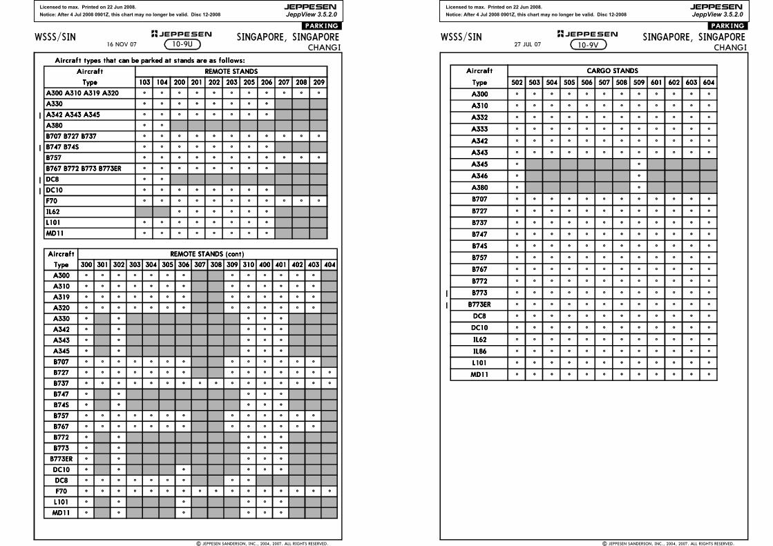
Licensed to max. Printed on 22 Jun 2008.
Notice: After 4 Jul 2008 0901Z, this chart may no longer be valid. Disc 12-2008
JEPPESEN
JeppView 3.5.2.0
| JEPPESEN SANDERSON, INC., 2004, 2007. ALL RIGHTS RESERVED.
SINGAPORE, SINGAPORECHANGI
WSSS/SIN JEPPESEN+.PARKING.
Aircraft types that can be parked at stands are as follows:Aircraft types that can be parked at stands are as follows:Aircraft types that can be parked at stands are as follows:Aircraft types that can be parked at stands are as follows:
AircraftAircraftAircraftAircraft REMOTE STANDSREMOTE STANDSREMOTE STANDSREMOTE STANDS
TypeTypeTypeType 103103103103 104104104104 200200200200 201201201201 202202202202 203203203203 205205205205 206206206206 207207207207 208208208208 209209209209
A300 A310 A319 A320A300 A310 A319 A320A300 A310 A319 A320A300 A310 A319 A320 ^ ^ ^ ^ ^ ^ ^ ^ ^ ^ ^
A330A330A330A330 ^ ^ ^ ^ ^ ^ ^ ^
A342 A343 A345A342 A343 A345A342 A343 A345A342 A343 A345 ^ ^ ^ ^ ^ ^ ^ ^
A380A380A380A380 ^ ^
B707 B727 B737B707 B727 B737B707 B727 B737B707 B727 B737 ^ ^ ^ ^ ^ ^ ^ ^ ^ ^ ^
B747 B74SB747 B74SB747 B74SB747 B74S ^ ^ ^ ^ ^ ^ ^ ^
B757B757B757B757 ^ ^ ^ ^ ^ ^ ^ ^ ^ ^ ^
B767 B772 B773 B773ERB767 B772 B773 B773ERB767 B772 B773 B773ERB767 B772 B773 B773ER ^ ^ ^ ^ ^ ^ ^ ^
DC8 DC8 DC8 DC8 ^ ^
DC10DC10DC10DC10 ^ ^ ^ ^ ^ ^ ^ ^
F70F70F70F70 ^ ^ ^ ^ ^ ^ ^ ^ ^ ^ ^
IL62IL62IL62IL62 ^ ^ ^ ^ ^ ^
L101L101L101L101 ^ ^ ^ ^ ^ ^ ^ ^
MD11MD11MD11MD11 ^ ^ ^ ^ ^ ^ ^ ^
AircraftAircraftAircraftAircraft REMOTE STANDS (cont)REMOTE STANDS (cont)REMOTE STANDS (cont)REMOTE STANDS (cont)
TypeTypeTypeType 300300300300 301301301301 302302302302 303303303303 304304304304 305305305305 306306306306 307307307307 308308308308 309309309309 310310310310 400400400400 401401401401 402402402402 403403403403 404404404404
A300A300A300A300 ^ ^ ^ ^ ^ ^ ^ ^ ^ ^ ^ ^ ^
A310A310A310A310 ^ ^ ^ ^ ^ ^ ^ ^ ^ ^ ^ ^ ^
A319A319A319A319 ^ ^ ^ ^ ^ ^ ^ ^ ^ ^ ^ ^ ^
A320A320A320A320 ^ ^ ^ ^ ^ ^ ^ ^ ^ ^ ^ ^ ^
A330A330A330A330 ^ ^ ^ ^ ^
A342A342A342A342 ^ ^ ^ ^ ^
A343A343A343A343 ^ ^ ^ ^ ^
A345A345A345A345 ^ ^ ^ ^ ^
B707B707B707B707 ^ ^ ^ ^ ^ ^ ^ ^ ^ ^ ^ ^ ^
B727B727B727B727 ^ ^ ^ ^ ^ ^ ^ ^ ^ ^ ^ ^ ^ ^
B737B737B737B737 ^ ^ ^ ^ ^ ^ ^ ^ ^ ^ ^ ^ ^ ^ ^ ^
B747B747B747B747 ^ ^ ^ ^ ^
B74SB74SB74SB74S ^ ^ ^ ^ ^
B757B757B757B757 ^ ^ ^ ^ ^ ^ ^ ^ ^ ^ ^ ^ ^
B767B767B767B767 ^ ^ ^ ^ ^ ^ ^ ^ ^ ^ ^ ^ ^
B772B772B772B772 ^ ^ ^ ^ ^
B773B773B773B773 ^ ^ ^ ^ ^
B773ERB773ERB773ERB773ER ^ ^ ^ ^ ^
DC10DC10DC10DC10 ^ ^ ^ ^ ^ ^
DC8DC8DC8DC8 ^ ^ ^ ^ ^ ^ ^ ^ ^
F70F70F70F70 ^ ^ ^ ^ ^ ^ ^ ^ ^ ^ ^ ^ ^ ^ ^ ^
L101L101L101L101 ^ ^ ^ ^ ^ ^
MD11MD11MD11MD11 ^ ^ ^ ^ ^ ^
10-9U16 NOV 07
Licensed to max. Printed on 22 Jun 2008.
Notice: After 4 Jul 2008 0901Z, this chart may no longer be valid. Disc 12-2008
JEPPESEN
JeppView 3.5.2.0
| JEPPESEN SANDERSON, INC., 2004, 2007. ALL RIGHTS RESERVED.
SINGAPORE, SINGAPORECHANGI
WSSS/SIN JEPPESEN+.PARKING.
AircraftAircraftAircraftAircraft CARGO STANDSCARGO STANDSCARGO STANDSCARGO STANDS
TypeTypeTypeType 502502502502 503503503503 504504504504 505505505505 506506506506 507507507507 508508508508 509509509509 601601601601 602602602602 603603603603 604604604604
A300A300A300A300 ^ ^ ^ ^ ^ ^ ^ ^ ^ ^ ^ ^
A310A310A310A310 ^ ^ ^ ^ ^ ^ ^ ^ ^ ^ ^ ^
A332A332A332A332 ^ ^ ^ ^ ^ ^ ^ ^ ^ ^ ^ ^
A333A333A333A333 ^ ^ ^ ^ ^ ^ ^ ^ ^ ^ ^ ^
A342A342A342A342 ^ ^ ^ ^ ^ ^ ^ ^ ^ ^ ^ ^
A343A343A343A343 ^ ^ ^ ^ ^ ^ ^ ^ ^ ^ ^ ^
A345A345A345A345 ^ ^
A346A346A346A346 ^ ^
A380A380A380A380 ^ ^
B707B707B707B707 ^ ^ ^ ^ ^ ^ ^ ^ ^ ^ ^ ^
B727B727B727B727 ^ ^ ^ ^ ^ ^ ^ ^ ^ ^ ^ ^
B737B737B737B737 ^ ^ ^ ^ ^ ^ ^ ^ ^ ^ ^ ^
B747B747B747B747 ^ ^ ^ ^ ^ ^ ^ ^ ^ ^ ^ ^
B74SB74SB74SB74S ^ ^ ^ ^ ^ ^ ^ ^ ^ ^ ^ ^
B757B757B757B757 ^ ^ ^ ^ ^ ^ ^ ^ ^ ^ ^ ^
B767B767B767B767 ^ ^ ^ ^ ^ ^ ^ ^ ^ ^ ^ ^
B772B772B772B772 ^ ^ ^ ^ ^ ^ ^ ^ ^ ^ ^ ^
B773B773B773B773 ^ ^ ^ ^ ^ ^ ^ ^ ^ ^ ^ ^
B773ERB773ERB773ERB773ER ^ ^ ^ ^ ^ ^ ^ ^ ^ ^ ^ ^
DC8DC8DC8DC8 ^ ^ ^ ^ ^ ^ ^ ^ ^ ^ ^ ^
DC10DC10DC10DC10 ^ ^ ^ ^ ^ ^ ^ ^ ^ ^ ^ ^
IL62IL62IL62IL62 ^ ^ ^ ^ ^ ^ ^ ^ ^ ^ ^ ^
IL86IL86IL86IL86 ^ ^ ^ ^ ^ ^ ^ ^ ^ ^ ^ ^
L101L101L101L101 ^ ^ ^ ^ ^ ^ ^ ^ ^ ^ ^ ^
MD11MD11MD11MD11 ^ ^ ^ ^ ^ ^ ^ ^ ^ ^ ^ ^
10-9V27 JUL 07
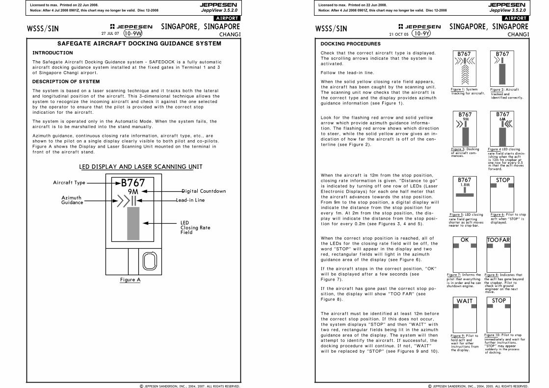
Licensed to max. Printed on 22 Jun 2008.
Notice: After 4 Jul 2008 0901Z, this chart may no longer be valid. Disc 12-2008
JEPPESEN
JeppView 3.5.2.0
WSSS/SIN JEPPESEN
10-9W
| JEPPESEN SANDERSON, INC., 2004, 2007. ALL RIGHTS RESERVED.
SINGAPORE, SINGAPORECHANGI
.AIRPORT.
INTRODUCTION
SAFEGATE AIRCRAFT DOCKING GUIDANCE SYSTEM
The Safegate Aircraft Docking Guidance system - SAFEDOCK is a fully automatic
DESCRIPTION OF SYSTEM
The system is based on a laser scanning technique and it tracks both the lateral and longitudinal position of the aircraft. This 3-dimensional technique allows the system to recognize the incoming aircraft and check it against the one selected
The system is operated only in the Automatic Mode. When the system fails, the aircraft is to be marshalled into the stand manually.
shown to the pilot on a single display clearly visible to both pilot and co-pilots.Azimuth guidance, continuous closing rate information, aircraft type, etc., are
Figure A shows the Display and Laser Scanning Unit mounted on the terminal in front of the aircraft stand.
Figure A
LEDClosing RateField
Lead-in Line
Digital Countdown
Aircraft Type
AzimuthGuidance
9MB767
LED DISPLAY AND LASER SCANNING UNIT
27 JUL 07
of Singapore Changi airport.aircraft docking guidance system installed at the fixed gates in Terminal 1 and 3
indication for the aircraft.by the operator to ensure that the pilot is provided with the correct stop
Licensed to max. Printed on 22 Jun 2008.
Notice: After 4 Jul 2008 0901Z, this chart may no longer be valid. Disc 12-2008
JEPPESEN
JeppView 3.5.2.0
WSSS/SIN JEPPESEN
21 OCT 05 10-9Y
| JEPPESEN SANDERSON, INC., 2004, 2005. ALL RIGHTS RESERVED.
SINGAPORE, SINGAPORECHANGI
.AIRPORT.
9M 6MM
1.8M
B767 B767Check that the correct aircraft type is displayed. The scrolling arrows indicate that the system is activated.
Follow the lead-in line.
When the solid yellow closing rate field appears, the aircraft has been caught by the scanning unit. The scanning unit now checks that the aircraft is the correct type and the display provides azimuth guidance information (see Figure 1).
Look for the flashing red arrow and solid yellow arrow which provide azimuth guidance informa-tion. The flashing red arrow shows which direction to steer, while the solid yellow arrow gives an in-dication of how far the aircraft is off of the cen-terline (see Figure 2).
When the aircraft is 12m from the stop position, closing rate information is given. "Distance to go" is indicated by turning off one row of LEDs (Laser Electronic Displays) for each one half meter that the aircraft advances towards the stop position.From 9m to the stop position, a digital display will indicate the distance from the stop position for every 1m. At 2m from the stop position, the dis-play will indicate the distance from the stop posi-tion for every 0.2m (see Figures 3, 4 and 5).
When the correct stop position is reached, all of the LEDs for the closing rate field will be off, the word "STOP" will appear in the display and two red, rectangular fields will light in the azimuth guidance area of the display (see Figure 6).
Figure 7).
If the aircraft stops in the correct position, "OK" will be displayed after a few seconds (see
Figure 8).
If the aircraft has gone past the correct stop po-sition, the display will show "TOO FAR" (see
The aircraft must be identified at least 12m before the correct stop position. If this does not occur, the system displays "STOP" and then "WAIT" with two red, rectangular fields being lit in the azimuth guidance area of the display. The system will then attempt to identify the aircraft. If successful, the docking procedure will continue. If not, "WAIT" will be replaced by "STOP" (see Figures 9 and 10).
TOOFAR
B767 B767
DOCKING PROCEDURES
Figure 4 LED closingrate field starts dimin-ishing when the acftis 12m fm stopbar atone row for every 0.5m that the acft movesforward.
of aircraft com-mences.
Figure 3: Docking
Figure 1: Systemtracking for aircraft.
Figure 2: Aircrafttracked andidentified correctly.
Figure 5: LED closing Figure 6: Pilot to stopacft when "STOP" isdisplayed.
Figure 7: Informs the
shutdown engine.
Figure 8: Indicates that the acft has gone beyond
immediately and wait forFigure 10: Pilot to stop
is in order and he canpilot that everything
B767 STOP
OK
WAIT STOP
instructions from
Figure 9: Pilot to
further instructions."STOP" may appear
of docking.suddenly in the processthe display.
wait for otherhold acft and
the stopbar. Pilot to
move.engineer on the nextcheck with ground
rate field getting
nearer to stop-bar.shorter as acft moves

Licensed to max. Printed on 22 Jun 2008.
Notice: After 4 Jul 2008 0901Z, this chart may no longer be valid. Disc 12-2008
JEPPESEN
JeppView 3.5.2.0
WSSS/SIN JEPPESEN
21 OCT 05 10-9Z
| JEPPESEN SANDERSON, INC., 2004, 2005. ALL RIGHTS RESERVED.
SINGAPORE, SINGAPORECHANGI
.AIRPORT.
SAFETY MEASURES
Pilots should not turn an aircraft into the parking
When using the docking system, pilots are to taxi into the aircraft stand at minimum speed. The system will display "SLOW DOWN" to inform the pilot if the aircraft's taxiing speed is too fast (see Figure 11).
To avoid overshooting, pilots are advised to approach the stop position slowly and observe the closing rate information displayed. Pilots should stop the aircraft immediately when seeing the "STOP" display or when given the stop sign by the aircraft marshaller.
stand if the docking system is not activated or on seeing a wrong aircraft type displayed on the system.
SLOWDOWN
Figure 11: Informs thepilot that the acft travelling speed is too fast.Pilot to slow down the speed.
Depicts solid yellowarrow.
Depicts flashing redarrow.
NOTE
Licensed to max. Printed on 22 Jun 2008.
Notice: After 4 Jul 2008 0901Z, this chart may no longer be valid. Disc 12-2008
JEPPESEN
JeppView 3.5.2.0
MALAYSIA
INDO
NESIA
168^INDONE
SIASINGAP
ORE
356^
3 56 ^PU
1 15 .1
WS(P)-3
WS(P)-24
WS(P)-36
WM(P)-228
WS(R)-2
WS(R)-31
WS(R)-38
WS(D)-1
WS(D)-4
WS(D)-33
WS(D)-34WS(D)-35
WS(D)-5Seletar
Paya Lebar
Hang Nadim
SINGA-PORE
MALAYSIA
637'
942'
500'
DSINJON
113.5 SJS J
SAMKO
ILS DME
023^ 110.9 ICWI C WANUMA
1 D16.6 ICW
023^
4000
3500023^
D8/14
1
SINGAPORE, SINGAPOREILS DME Rwy 02L
Ground
124.3
MISSED APCH:
CHANGI 11-1SINGAPORE Approach (R) SINGAPORE Arrival (R)
128.6 119.3LOC
110.9ICW
FinalApch Crs023^
GS
(3478')
ILSDA(H)
222'3500'
120.3SINGAPORE Tower
118.6
(200')
PANS OPS
| JEPPESEN SANDERSON, INC., 1998, 2006. ALL RIGHTS RESERVED.
D-ATIS
Alt Set: hPa Rwy Elev: 1 hPa Trans level: FL 130 Trans alt: 11000'
(GS out)ICW DMELOC 2.04.0
1290'
WSSS/SIN
348^
168^
FMS required forholding during SJ VOR
01-10
103-50 104-00 104-10
ALTITUDE
outage.
Air Force (RSAF) Aircraft
3.0
CAUTION: Changi East Rwy02R/20L is solely for use bythe Republic of Singapore
D116.5 VTKTEKONG
V T K
D11.1 ICW
AKIPOD7.8 ICW
ADNIKD4.6 ICW
ABVOND0.7 ICW
D16.0 ICWAPIPA
Gnd speed-Kts
REILPAPI PAPI
GS 3.00^FAF to MAP 3.9
MAP at ABVON/D0.7 ICW1
70 90 100 120 140 160377 484 538 646 753 8613:21 2:36 2:20 1:57 1:40 1:28
A
B
C
D
ILS
FULL ALS out
1200m
LOC (GS out)
ALS out
ALSF-II
1 Timing not authorized when GS inop.
CIRCLE-TO-LAND
NA
A
B
C
D
660'970'
ANUMA
Climb to 1000', then climbing LEFT turn to 4000' via
335^hdgAKOMA
3 56 ^
1 76 ^
D20.0 PU
4 00 0
BRIEFING STRIP
TM
hdg
335^1000'
LT
4000'
STRAIGHT-IN LANDING RWY02L
RVR 550mVIS 800m
RVR 720mVIS 800m
or CL outTDZDA(H) 222'(200') MDA(H) 420'(398')
RVR 720mVIS 800m
1200m
RVR 1500mVIS 1600m
RVR 1800mVIS 2000m
APCH FIXMISSED
360^
090^
3400'
2100'
180^
1900'
MSA VTK VOR
directed by ATC.heading 335^ and PU R-356 to AKOMA (PU R-356/D20.0) and hold or as
RWY 02L 22'22'Apt Elev
1. RADAR required. 2. Simultaneous approaches authorized with Rwy 2R or 2C. 3. ILSDME co-located with glideslope. 4. Maritime vessels of variable heights in water north
01-20
3500'
3.3 3.2 3.9
TCH 58'
RWY 02L 22'1500'
ANUMAD11.1 ICW AKIPO
ADNIKABVON
D7.8 ICW
D4.6 ICWD0.7 ICW2500'
0.5
023^
PAPA UNIFORM
115.1 PUPUD
4.9
via
3500
D8.0 SJ/R-168
17 NOV 06
and south of Rwy.
Note removed.
WS(P)-49
535'
620'
436'
656'
680'
630'
440'
550'
611'
602'
437'
1017'
CHANGES:
523'
JEPPESEN

Licensed to max. Printed on 22 Jun 2008.
Notice: After 4 Jul 2008 0901Z, this chart may no longer be valid. Disc 12-2008
JEPPESEN
JeppView 3.5.2.0
MALAYSIA
INDO
NESIA
168^
INDONESIA
SINGAPORE
356^
3 56 ^PU
1 15 .1
WS(P)-3
WS(P)-24
WS(P)-36
WM(P)-228
WS(R)-2
WS(R)-31WS(R)-38
WS(D)-1
WS(D)-4
WS(D)-33
WS(D)-34WS(D)-35
WS(D)-5Seletar
Paya Lebar
Hang Nadim
SINGA-PORE
MALAYSIA
ILS DME Rwy 02L CAT II
CAT II ILS
RA 104'
637'
942'
500'
DSINJON
113.5 SJS J
SAMKO
ILS DME
023^ 110.9 ICWI C WANUMA
1 D16.6 ICW
023^
4000
3500023^
D8/14
1
SINGAPORE, SINGAPORE
Ground
124.3
MISSED APCH:
CHANGISINGAPORE Approach (R) SINGAPORE Arrival (R)
128.6 119.3LOC
110.9ICW
FinalApch Crs023^
GS
(3478')3500'
120.3SINGAPORE Tower
118.6
PANS OPS
| JEPPESEN SANDERSON, INC., 1998, 2006. ALL RIGHTS RESERVED.
D-ATIS
Alt Set: hPa Rwy Elev: 1 hPa Trans level: FL 130 Trans alt: 11000'
WSSS/SIN
348^
168^
FMS required forholding during SJ VOR
01-10
103-50 104-00 104-10outage.
Air Force (RSAF) Aircraft
CAUTION: Changi East Rwy02R/20L is solely for use bythe Republic of Singapore
D116.5 VTKTEKONG
V T K
D11.1 ICW
D16.0 ICWAPIPA
Gnd speed-Kts
REILPAPI PAPI
GS 3.00^70 90 100 120 140 160377 484 538 646 753 861
ALSF-II
ANUMA
Climb to 1000', then climbing LEFT turn to 4000' via
335^hdg
AKOMA
3 56 ^
1 76 ^
D20.0 PU
4 00 0
BRIEFING STRIP
TM
hdg
335^1000'
LT
4000'
APCH FIXMISSED
360^
090^
3400'
2100'
180^
1900'
MSA VTK VOR
directed by ATC.heading 335^ and PU R-356 to AKOMA (PU R-356/D20.0) and hold or as
RWY 02L 22'22'Apt Elev
01-20
3500'
10.9
TCH 58'
RWY 02L 22'
ANUMAD11.1 ICW
023^
PAPA UNIFORM
115.1 PUPUD
11-1A
DA(H)122'(100')
DA(H) 122'(100')
STRAIGHT-IN LANDING RWY
DA(H) 172'(150')
500m350m
02L
4.9
via
3500
D8.0 SJ/R-168
Note removed.
17 NOV 06
3. Simultaneous approaches authorized with Rwy 2R or 2C. 4. ILS DME co-located withglideslope. 5. Maritime vessels of variable heights in water north and south of Rwy.
1. Special Aircrew and Acft Certification Required. 2. RADAR required.
WS(P)-49
535'
620'
436'
656'
680'
630'
440'550'
611'
602'
437'
1017'
CHANGES:
523'
JEPPESEN
RA 104'CAT II ILS
RA 160'
RVRRVR
Licensed to max. Printed on 22 Jun 2008.
Notice: After 4 Jul 2008 0901Z, this chart may no longer be valid. Disc 12-2008
JEPPESEN
JeppView 3.5.2.0
SINGAPORE
INDONESIA
MALAYSIA
168^SJ
113.5
023^
VTK
116.5
WS(D)-34
WS(R)-38
Paya Lebar
Seletar
WS(P)-36
Hang Nadim
LOC(GS out)
348^
168^
023^1.8
023^
SAMKO
4000
4500 436'
440'
D8/14
ALT
LOC
(GS out)
611'
DSINJON
113.5 SJS J
TEKONG116.5 VTKV T KD
ICE DME
ILS DME
023^ 108.3 ICEI C E
680'
4.0
1290' 970'
3.0
LEPNA
D15.6 ICED8.0 SJ
MISSED APCH:
SINGAPORE, SINGAPORECHANGI ILS DME Rwy 02C
LOC
108.3ICE
FinalApch Crs
023^
GS
4500'(4485')
ILSDA(H)
215'(200')
Apt Elev 22'RWY 02C 15'
SINGAPORE Approach (R) SINGAPORE Arrival (R) SINGAPORE Tower Ground
128.6 120.3 119.3 118.6 124.3
1200m
ILS LOC (GS out)
ALS outALS outALS outFULL
1200m2800m
3200m2400m
NOT TOSCALE
1017'
1
1
11-2
Alt Set: hPa Rwy Elev: 1 hPa Trans level: FL 130 Trans alt: 11000'
01-20
104-00 104-10
WSSS/SIN
PANS OPS
| JEPPESEN SANDERSON, INC., 1998, 2005. ALL RIGHTS RESERVED.
D-ATIS
CAUTION: Changi East Rwy02R/20L is solely for use bythe Republic of Singapore Air Force (RSAF) Aircraft
203^
023^
3000
D13/19
29 JUL 05 .Eff.4.Aug.
LEPNA
Climb to 3000' via heading 023^ and VTK R-023 to NYLON(VTK R-023/D13.0) and hold or as directed by ATC.
023^
hdg
NYLOND13.0 VTK
MISSEDAPCH FIX
1. RADAR required. 2. Simultaneous approaches authorized with Rwy 2R or 2L. 3. ILS DMEco-located with glide slope. 4. Maritime vessels of variable heights in water north and southof Rwy. 5. For acft speed restrictions refer to ATC Singapore-1 or Singapore Area 10-1.
LELOND7.8 ICE
LASIND4.6 ICE
LUXOLD2.0 ICE
D0.7 ICELAGUS
D14.2 ICE
LIDVAD16.0 ICE
4500'
6.4 3.2 1.3
TCH 59'
RWY 02C 15'
2500'
0.5
023^D0.7 ICE
D2.0 ICE
LASIND4.6 ICE
LELOND7.8 ICE
LEPNAD14.2 ICE
2.6
Gnd speed-KtsGS 3.00^
FAF to MAP 3.9MAP at LAGUS/D0.7 ICE1
70 90 100 120 140 160377 484 538 646 753 8613:21 2:36 2:20 1:57 1:40 1:28 PAPI
REILPAPI
ALSF-I VTK
R-023116.5via and
3000'
1 Timing not authorized when GS inop.
CIRCLE-TO-LAND
NA
With LUXOL/D2.0 ICE Without LUXOL/D2.0 ICE
A
B
C
D
A
B
C
D
MDA(H) 420'(405') MDA(H) 660'(645')
Procedure.
LAGUSLUXOL
BRIEFING STRIP
TM
hdg
023^
MSA VTK VOR
3400'
090^
180^
360^
1900'
2100'
RVR
VIS 800m
720mRVRVIS 800m
720m RVR 1500mVIS 1600m 800mVIS
RVR 720m RVR 1500mVIS 1600m
1800m2000mVIS
RVR
DA(H) 215'(200')
2000mRVR 1800mVIS
STRAIGHT-IN LANDING RWY02C
FMS required for holdingduring SJ VOR outage.
4500
CHANGES:
523'
JEPPESEN
1500'
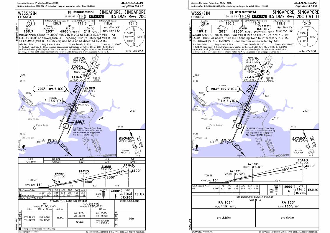
Licensed to max. Printed on 22 Jun 2008.
Notice: After 4 Jul 2008 0901Z, this chart may no longer be valid. Disc 12-2008
JEPPESEN
JeppView 3.5.2.0
SINGAPORE
MALAYSIA
INDONESIA
SINGAPORE
MALAYSIA
158^VTK
116.5
023^
VTK
116.5
Seletar
Paya Lebar
WS(P)-36
WS(R)-38
WS(D)-34
158^VTK116.5
627'
440'
611'
602'
203^
PANS OPS
920'
D 116.5 VTKTEKONG
V T K
I C C ILS DME
203^ 109.7 ICC
680'
573'
MISSED APCH:
SINGAPORE, SINGAPORECHANGI ILS DME Rwy 20C11-3
SINGAPORE Approach (R) SINGAPORE Arrival (R) SINGAPORE Tower Ground
128.6 120.3 119.3 118.6 124.3LOC
109.7ICC
FinalApch Crs
203^
GS
4500'(4485')
ILSDA(H)
215'(200')
ESLUX (1000' or above) turn LEFT heading 130^ to intercept VTK R-158
Alt Set: hPa Rwy Elev: 1 hPa Trans level: FL 130 Trans alt: 11000'
01-20
01-30
WSSS/SIN
D-ATIS
| JEPPESEN SANDERSON, INC., 1998, 2005. ALL RIGHTS RESERVED.
500'
CAUTION: Changi East Rwy02R/20L is solely for use bythe Republic of Singapore Air Force (RSAF) Aircraft
co-located with glide slope. 4. Maritime vessels of variable heights in water north and south
29 JUL 05 .Eff.4.Aug.
Procedure.
ELALU
Climb to 4000' via VTK R-203 to ESLUX (D6.7 VTK). At
to EXOMO (VTK R-158/D22.0) and hold or as directed by ATC.
1. RADAR required. 2. Simultaneous approaches authorized with Rwy 20L or 20R. 3. ILS DME
ELBEBD7.8 ICC
ELMIN
D0.7 ICCESBIT
of Rwy. 5. For acft speed restrictions refer to ATC Singapore-1 or Singapore Area 10-1.
NYLOND16.7 ICCD13.0 VTK
1.8
4500203^ 023^
3000
D13/19
203^
ELALUD14.2 ICC
EGORAD16.0 ICC
BRIEFING STRIP
TM
RWY 20C 15'22'Apt Elev
(GS out)LOC
ALTITUDEICC DME
650'2.0
970'3.0
1290'4.0
MISSEDAPCH FIX
104-10
EXOMOD22.0 VTK
338^
4000158^
104-00
PAPIREIL
ELALUD14.2 ICCELBEB
D7.8 ICC
6.43.23.9
TCH 58'
15'1500'
2500'
0.5
203^4500'ELMIN
D0.7 ICCESBIT
Gnd speed-KtsGS 3.00^
FAF to MAP 3.9MAP at ESBIT/D0.7 ICC1
70 90 100 120 140 160377 484 538 646 753 8613:21 2:36 2:20 1:57 1:40 1:28
A
B
C
D
ILS
FULL ALS out
1200m
LOC (GS out)
ALS out
1 Timing not authorized when GS inop.
CIRCLE-TO-LAND
NA
A
B
C
D
4000'
R-203
VTK
116.5via ESLUX
ALSF-II
STRAIGHT-IN LANDING RWY20C
DA(H) 215'(200') MDA(H) 420'(405')
1200mRVR 1800mVIS 2000m
RVR 720mVIS 800m
RVR 1500mVIS 1600m
090^
180^
360^
1900'
2100'
3400'
MSA VTK VOR
NOT TOSCALE
130^hdg
RWY 20C
ESLUXD6.7 VTK
VIS 800mRVR 720m
TDZ or CL out
RVR 550mVIS 800m
4500
D4.6 ICC
D4.6 ICC
CHANGES:
JEPPESEN
Licensed to max. Printed on 22 Jun 2008.
Notice: After 4 Jul 2008 0901Z, this chart may no longer be valid. Disc 12-2008
JEPPESEN
JeppView 3.5.2.0
SINGAPORE
MALAYSIA
INDONESIA
SINGAPORE
MALAYSIA
158^VTK
116.5
023^
VTK
116.5
Seletar
Paya Lebar
WS(P)-36
WS(R)-38
WS(D)-34
158^VTK116.5
CAT II ILSRA 102'
ILS DME Rwy 20C CAT II
4500'
14.0
203^
627'
440'
611'
602'
203^
PANS OPS
920'
D 116.5 VTKTEKONG
V T K
I C C ILS DME
203^ 109.7 ICC
680'
573'
MISSED APCH:
SINGAPORE, SINGAPORECHANGI
SINGAPORE Approach (R) SINGAPORE Arrival (R) SINGAPORE Tower Ground
128.6 120.3 119.3 118.6 124.3LOC
109.7ICC
FinalApch Crs
203^
GS
4500'(4485')
ESLUX (1000' or above) turn LEFT heading 130^ to intercept VTK R-158
Alt Set: hPa Rwy Elev: 1 hPa Trans level: FL 130 Trans alt: 11000'
01-20
01-30
WSSS/SIN
D-ATIS
| JEPPESEN SANDERSON, INC., 1998, 2005. ALL RIGHTS RESERVED.
500'
CAUTION: Changi East Rwy02R/20L is solely for use bythe Republic of Singapore Air Force (RSAF) Aircraft
co-located with glide slope. 4. Maritime vessels of variable heights in water north and south
29 JUL 05 .Eff.4.Aug.
Procedure.
ELALU
Climb to 4000' via VTK R-203 to ESLUX (D6.7 VTK). At
to EXOMO (VTK R-158/D22.0) and hold or as directed by ATC.
1. RADAR required. 2. Simultaneous approaches authorized with Rwy 20L or 20R. 3. ILS DME
of Rwy. 5. For acft speed restrictions refer to ATC Singapore-1 or Singapore Area 10-1.
NYLOND16.7 ICCD13.0 VTK
1.8
4500203^ 023^
3000
D13/19
203^
ELALUD14.2 ICC
EGORAD16.0 ICC
BRIEFING STRIP
TM
RWY 20C 15'22'Apt Elev
MISSEDAPCH FIX
104-10
EXOMOD22.0 VTK
338^
4000158^
104-00
PAPIREIL
ELALUD14.2 ICC
TCH 58'
15'
Gnd speed-KtsGS 3.00^
70 90 100 120 140 160377 484 538 646 753 861
4000'
R-203
VTK
116.5via ESLUX
ALSF-II
090^
180^
360^
1900'
2100'
3400'
MSA VTK VOR
NOT TOSCALE
130^hdg
RWY 20C
ESLUXD6.7 VTK
11-3A
115'(100')DA(H)
STRAIGHT-IN LANDING RWY20C
115'DA(H) (100') DA(H) 165'(150')
350m 500m
4500
RA 102'
RA 153'
CHANGES:
JEPPESEN
DA(H)165'(150')
115'(100')DA(H)
CAT II ILSRA 102' RA 153'
RVR RVR
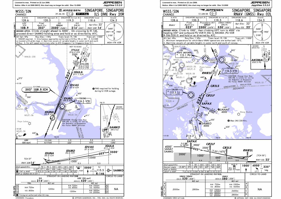
Licensed to max. Printed on 22 Jun 2008.
Notice: After 4 Jul 2008 0901Z, this chart may no longer be valid. Disc 12-2008
JEPPESEN
JeppView 3.5.2.0
SINGAPORE
MALAYSIA
MALAYSIA
SINGAPORE
Seletar
Paya Lebar
WM(D)-230
WS(R)-38
WS(P)-36 WS(D)-34
VTK
023^
116.5
JS168^SJ113.5
146^
113.5SJJS
203^
602'
611'
761'
440'
TEKONG
116.5 VTKDV T K680'
ILS DME
203^ 108.9 ICHI C H
(GS out) ALTITUDE 650' 970' 1290'
PANS OPS
4.03.02.0ICH DMELOC
2100'
090^
180^
360^
3400'
1900'MISSED APCH:
SINGAPORE, SINGAPORECHANGI ILS DME Rwy 20R11-4
LOC
108.9 ICH
FinalApch Crs
203^
GS
3500'(3486')
ILSDA(H)
214'(200')Apt Elev 22'
RWY 20R 14'
MSA VTK VOR
SINGAPORE Approach (R) SINGAPORE Arrival (R) SINGAPORE Tower Ground
128.6 120.3 119.3 118.6 124.3
FMS required for holdingduring SJ VOR outage.
1
Rwy Elev: 1 hPa Trans level: FL 130 Trans alt: 11000'
01-20
01-30
104-00
104-10
WSSS/SIN
D-ATIS
| JEPPESEN SANDERSON, INC., 1998, 2005. ALL RIGHTS RESERVED.
500'
CAUTION: Changi East Rwy02R/20L is solely for use bythe Republic of Singapore Air Force (RSAF) Aircraft
573'
29 JUL 05 .Eff.4.Aug.
Procedure.
Alt Set: hPa1. RADAR required. 2. Simultaneous approaches authorized with Rwy 20L or 20C. 3. ILS DMEco-located with glide slope. 4. Maritime vessels of variable heights in water north and southof Rwy. 5. For acft speed restrictions refer to ATC Singapore-1 or Singapore Area 10-1.
IGULA
Climb straight ahead to 5000'. On crossing SJ R-146,proceed direct SAMKO holding area and hold or as directed by ATC.
IDUNAD0.8 ICH
IDUROD4.6 ICH
IDVASD7.8 ICH
IGULAD11.1 ICH
BRIEFING STRIP
TM
NYLOND16.2 ICHD13.0 VTK
203^
023^
3000
D13/19
D16.0 ICHIPNAK
203^
3500
NOT TO SCALE
348^
SAMKOD8.0 SJ1
5000168^
MISSEDAPCH FIX
1200m
ILS LOC (GS out)
ALS outALS outFULL
1200m
Gnd speed-KtsGS 3.00^
FAF to MAP 3.9MAP at IDUNA/D0.8 ICH1
70 90 100 120 140 160377 484 538 646 753 8613:21 2:36 2:20 1:57 1:40 1:28
1 Timing not authorized when GS inop.
CIRCLE-TO-LAND
NARVR
VIS 800m
720mRVRVIS 800m
720m RVR 1500mVIS 1600m
ABCD 2000m
RVR 1800mVIS
ABCD
5000'PAPIREIL
PAPI
R-146
SJ
113.5 SAMKODALSF-I
oncrossing
MDA(H) 420'(406')DA(H) 214'(200')
3500'
3.33.2
2500'
0.6
203^
3.8
TCH 57'
RWY 20R 14'
IDUNAD0.8 ICH
IDUROD4.6 ICH
IGULAD11.1 ICHIDVAS
D7.8 ICH
STRAIGHT-IN LANDING RWY20R
4.9
3500
D8/14
CHANGES:
JEPPESEN
1500'
Licensed to max. Printed on 22 Jun 2008.
Notice: After 4 Jul 2008 0901Z, this chart may no longer be valid. Disc 12-2008
JEPPESEN
JeppView 3.5.2.0
MALAYSIA
INDO
NESIA
168^INDONE
SIASINGAP
ORE
356^
3 56 ^PU
1 15 .1
SINGA-PORE
MALAYSIA
WS(P)-3
WS(P)-24
WS(P)-36
WM(P)-228
WS(R)-2
WS(R)-31
WS(R)-38
WS(D)-1
WS(D)-4
WS(D)-33
WS(D)-34WS(D)-35
WS(D)-5Seletar
Paya Lebar
Hang Nadim
[TCH 50']
[3.00^]
0.4 NMto SAPAX
637'
942'
500'
DSINJON
113.5 SJS J
SAMKO
023^
4000
SINGAPORE, SINGAPORE
Ground
124.3
MISSED APCH:
CHANGI 12-1SINGAPORE Approach (R) SINGAPORE Arrival (R)
128.6 119.3
RNAVFinal
Apch Crs023^ (2478')
DA(H)
530'2500'
120.3SINGAPORE Tower
118.6
(508')
PANS OPS
D-ATIS
Alt Set: hPa Rwy Elev: 1 hPa Trans level: FL 130 Trans alt: 11000'
WSSS/SIN
348^
168^
01-10
104-00 104-10
Air Force (RSAF) Aircraft
CAUTION: Changi East Rwy02R/20L is solely for use bythe Republic of Singapore
D116.5 VTKTEKONG
V T K
Gnd speed-Kts
REILPAPI PAPI
70 90 100 120 140 160
A
B
C
D
ALS out
2800m
ALS out
ALSF-II
CIRCLE-TO-LAND
NA
A
B
C
D
C~2LF
Climb to 1000', then climbing LEFT turn to 4000' via
335^hdg
AKOMA
3 56 ^
1 76 ^
D20.0 PU
40 00
01-20
4.4 2.6 5.0 RWY 02L 22'
SAPAXC~2LF
C~2LSRW~2L
1000'
023^
PAPA UNIFORM115.1 PUPUD
via
STRAIGHT-IN LANDING RWY02L
Rwy 02L 22'22'Apt Elev
RNAV (GNSS) Rwy 02L
R-356/D20.0) and hold or as directed by ATC.heading 335^ and outbound PU VOR R-356 to AKOMA (PU VOR
LNAV/VNAV
LNAV/VNAV LNAVDA(H) 530'(508') MDA(H) 580'(558')
MAP at RW~2L
7.6 6:31 5:04 4:34 3:48 3:15 2:51
SAPAX
(IAF)
(IAF)
(IF)
SANAT
C~2LF
C~2LS
Descent angle [3.00^] 372 478 531 637 743 849
05.07.612.0
RW~2L
2. Maritime vessels of variable heights in water north and south of runway.1. Minimum temperature for which Baro-VNAV operations are authorized: 15^C.
D14.0SJ
1
11 Max IAS 220 Kts.
Procedure Alt
2500'3900'
MDA
290^
013^
C~2LF to MAP
RVR 1500mVIS 1600m
2800m
2400m
RVR 720mVIS 800m
RVRVIS 1600m
1500m
RVRVIS 2000m
1800m
3900
3900
5.9
4.5
2000m
01-00
4000
4000
BRIEFING STRIP
TM
hdg
335^1000'
LT
4000'
APCH FIXMISSED
360^
090^
3400'
2100'
180^
1900'
MSA VTK VOR
4 NM
660'2000'
4000'SANATSAMKO
13 JUN 08
C~2LS altitude. | JEPPESEN, 2007, 2008. ALL RIGHTS RESERVED.
1670'
WS(P)-49
535'
620'
436'
656'
680'
630'
440'550'
611'
602'
437'
1017'
CHANGES:
523'
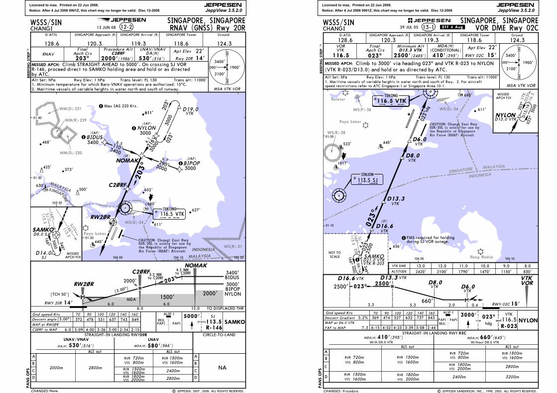
Licensed to max. Printed on 22 Jun 2008.
Notice: After 4 Jul 2008 0901Z, this chart may no longer be valid. Disc 12-2008
JEPPESEN
JeppView 3.5.2.0
MALAYSIA
168^
146^
SJ
SJ
113.5
113.5
SJ
SJ
INDONESIA
MALAYSIA
Paya Lebar
WM(R)-229
WM(D)-230
WM(D)-231
WS(R)-31
WS(D)-34
SINGAPOR
E
[TCH 50'][3.00
^]
4.5 NMto C2~RF3.2 NM
to C2~RF
500'
SINGAPORE, SINGAPORE
Ground
124.3
MISSED APCH:
CHANGI 12-2SINGAPORE Approach (R) SINGAPORE Arrival (R)
128.6 119.3
RNAVFinal
Apch Crs203^ (1986')
DA(H)
530'2000'
120.3
SINGAPORE Tower
118.6
(516')
PANS OPS
D-ATIS
Alt Set: hPa Rwy Elev: 1 hPa Trans level: FL 130 Trans alt: 11000'
WSSS/SIN
Air Force (RSAF) Aircraft
CAUTION: Changi East Rwy02R/20L is solely for use bythe Republic of Singapore
REILPAPI PAPI
A
B
C
D
ALS out
2800m
ALS out
CIRCLE-TO-LAND
NA
A
B
C
D
C2~RF
6.06.0RWY 20R 14'
NOMAK
C2~RF
RW2~R
1500'
203^
STRAIGHT-IN LANDING RWY20R
Rwy 20R 14'22'Apt Elev
RNAV (GNSS) Rwy 20R
LNAV/VNAV
LNAV/VNAV LNAV
DA(H) 530'(516') MDA(H) 580'(566')
MAP at RW2~R
Descent angle [3.00^] 372 478 531 637 743 849
0 6.0 12.0
2. Maritime vessels of variable heights in water north and south of runway.1. Minimum temperature for which Baro-VNAV operations are authorized: 15^C.
Procedure Alt
2000'
MDA
C2~RF to MAP
RVR 1500mVIS 1600m
2800m
2400m
RVR 720mVIS 800m
RVRVIS 1600m
1500m
RVRVIS 2000m
1800m
2000m
Climb STRAIGHT AHEAD to 5000'. On crossing SJ VORR-146, proceed direct to SAMKO holding area and hold or as directedby ATC.
5000'cross
SJ
113.5R-146
SAMKO6.0 5:09 4:00 3:36 3:00 2:34 2:15
TO DISPLACED THR
3400'
3000'
TEKONG116.5 VTKVTKD
RW2~R
C2~RF
NOMAK BIPOP
BIDUS
NYLON(IAF)
(IAF)
(IAF)(IF)
203^
023^
D19.0VTK
3000
SAMKO
348^
168^
D14.0SJ
MISSEDAPCH FIX
203^
110^
290^
216^6.5 4.1
6.7
3000
3000
3400
5000
D8.0 SJ
1
1
1
1Max IAS 220 Kts.
3400
3000
3000
01-20
01-30
01-40
103-50
104-00 104-10 104-20
BRIEFING STRIP
TM
360^
090^
3400'
2100'
180^
1900'
MSA VTK VOR
ALSF-I
468'
573'
BIDUS
BIPOPNYLON2000'
Gnd speed-Kts 70 90 100 120 140 160
13 JUN 08
None. | JEPPESEN, 2007, 2008. ALL RIGHTS RESERVED.
680'
440'
611'
602'
CHANGES:
611'
425'
627'
611'
630'
Licensed to max. Printed on 22 Jun 2008.
Notice: After 4 Jul 2008 0901Z, this chart may no longer be valid. Disc 12-2008
JEPPESEN
JeppView 3.5.2.0
SINGAPORE
INDONESIA
MALAYSIA
Paya Lebar
168^
Seletar
WS(D)-34WS(P)-36
WS(R)-38
D8
SJ
113.5
Hang Nadim
023^
VTK
116.5
348^
023^
023^
(IF)
168^
2500
4000D8/14
436'
440'
611'
D116.5 VTKTEKONG
V T K
D113.5 SJS J
SINJON
680'
10.0 9.0 8.011.0VTK DME
1470' 1150' 830'1790'
SAMKO
70 90 100 120 140 160
A
B
C
D
PANS OPS
STRAIGHT-IN LANDING RWY 02C
With D8.0 VTK Without D8.0 VTK
RVR
VIS 1600m1500m
VIS 1600mRVR 1500m
MDA(H)410'
ALS out ALS out
MDA(H)
1500m1600mVIS
RVRRVR 720m
800mVIS
RVR 720m800mVIS
(395')
RVRVIS
660'
2800m
3200m
1800m2000m
MAP at D6.0 VTK
(645')
RVRVIS
1800m2000m
2400m
Gnd speed-Kts
VTKD16.6
D6.0VTK
NOT TOSCALE
VTKD13.3
MISSED APCH:
SINGAPORE, SINGAPORECHANGI VOR DME Rwy 02C13-1
VOR
116.5VTK
FinalApch Crs
023^
Minimum Alt
2500'(2485')
MDA(H)
410'(395')
Apt Elev 22'RWY 02C 15'
(CONDITIONAL)
090^
180^
360^
2100'
3400'
1900'
MSA VTK VOR
SINGAPORE Approach (R) SINGAPORE Arrival (R) SINGAPORE Tower Ground
128.6 120.3 119.3 118.6 124.3
2500'
2.0
2500'023^
0.4 15'RWY 02C3.3 5.3660'
D16.6 VTK D13.3 VTKD8.0VTK D6.0
VTK
1
1
1017'
D13.3 VTK
| JEPPESEN SANDERSON, INC., 1998, 2005. ALL RIGHTS RESERVED.
01-10
01-20
104-00 104-10
WSSS/SIN
D-ATIS
Trans alt: 11000'Trans level: FL 130Alt Set: hPa Rwy Elev: 1 hPa
ALTITUDE
BRIEFING STRIP
TM
203^
023^
3000
D13/19
NYLOND13.0 VTK
MISSEDAPCH FIX
Climb to 3000' via heading 023^ and VTK R-023 to NYLON(VTK R-023/D13.0) and hold or as directed by ATC.
D8.0VTK
Descent Gradient 5.2% 369 474 527 632 737 843
FAF to MAP 7.3 6:15 4:52 4:23 3:39 3:08 2:44
12.02100'
13.02420'
NYLONPAPIREIL
ALSF-I
PAPI
VTK
R-023116.5via and
3000'
hdg
023^
Procedure.
29 JUL 05 .Eff.4.Aug.
4.4
FMS required for holdingduring SJ VOR outage.
speed restrictions refer to ATC Singapore-1 or Singapore Area 10-1.1. Maritime vessels of variable heights in water north and south of Rwy. 2. For aircraft
023
hdg
VTKVOR
VTK R-203D21.0 VTK
Air Force (RSAF) Aircraftthe Republic of Singapore 02R/20L is solely for use byCAUTION: Changi East Rwy
CHANGES:
JEPPESEN
523'
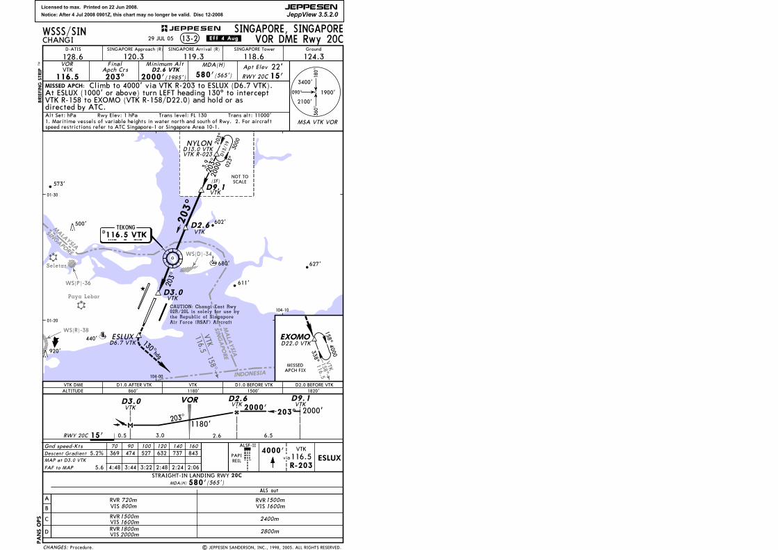
Licensed to max. Printed on 22 Jun 2008.
Notice: After 4 Jul 2008 0901Z, this chart may no longer be valid. Disc 12-2008
JEPPESEN
JeppView 3.5.2.0
MALAYSIA
SINGAPORE
INDONESIA
SINGAPORE
MALAYSIA
Seletar
WS(D)-34
WS(R)-38
WS(P)-36
158^VTK116.5
116.5VTK
158^
Paya Lebar
V T K
203^
(IF)
627'
440'
611'
602'
920'
3000
023^
203^
2000
D13/19
203^
NYLOND13.0 VTK
680'
VTKD9.1
VTKD2.6
203^
D3.0VTK
MISSED APCH:
SINGAPORE, SINGAPORECHANGI VOR DME Rwy 20C13-2
SINGAPORE Approach (R) SINGAPORE Arrival (R) SINGAPORE Tower Ground
128.6 120.3 119.3 118.6 124.3VOR
116.5 VTK
FinalApch Crs
203^
Minimum Alt
2000'(1985')
MDA(H)
580'(565')Apt Elev 22'RWY 20C 15'
D2.6 VTK
090^
180^
360^
1900'
2100'
3400'
MSA VTK VOR
MAP at D3.0 VTK
PANS OPS
20C
A
B
C
D
STRAIGHT-IN LANDING RWYMDA(H) 580'(565')
ALS out
1500mRVRVIS 1600m
2400m
2800m
RVR 720m800mVIS
RVR1500m1600mVIS
RVRVIS2000m
1800m
Gnd speed-Kts 70 90 100 120 140 160
PAPIREIL
VTK DME D1.0 AFTER VTK860' 1820'
D2.0 BEFORE VTK
573'
D116.5 VTKTEKONG
ALTITUDE
| JEPPESEN SANDERSON, INC., 1998, 2005. ALL RIGHTS RESERVED.
01-20
01-30
104-00
WSSS/SIN
D-ATIS
500'
Alt Set: hPa Rwy Elev: 1 hPa Trans level: FL 130 Trans alt: 11000'
ALSF-II
BRIEFING STRIP
TM
MISSEDAPCH FIX
EXOMOD22.0 VTK
338^
4000158^
104-10
ESLUX130^hdg
1180'VTK D1.0 BEFORE VTK
1500'
Descent Gradient 5.2% 369 474 527 632 737 843
FAF to MAP 5.6 4:48 3:44 3:22 2:48 2:24 2:06
4000'
R-203
VTK
116.5via ESLUX
Procedure.
29 JUL 05 .Eff.4.Aug.
Climb to 4000' via VTK R-203 to ESLUX (D6.7 VTK).
directed by ATC.
At ESLUX (1000' or above) turn LEFT heading 130^ to intercept
3.9
NOT TOSCALE
RWY 20C 15' 3.0 2.6
2000'
6.5
203^ 2000'203^
0.5
1180'
VTKD3.0 VTK
D2.6VTKD9.1
speed restrictions refer to ATC Singapore-1 or Singapore Area 10-1.1. Maritime vessels of variable heights in water north and south of Rwy. 2. For aircraft
Air Force (RSAF) Aircraftthe Republic of Singapore 02R/20L is solely for use byCAUTION: Changi East Rwy
VTK R-023
VTK R-158 to EXOMO (VTK R-158/D22.0) and hold or as
D6.7 VTK
CHANGES:
JEPPESEN
VOR