Writing the history of North America from Indian country ...
29
Journal de la Société des américanistes 105-1 | 2019 105-1 Writing the history of North America from Indian country: the view from the north-central Plains, 1800-1870 Écrire l’histoire de l’Amérique du Nord depuis le pays indien : le cas des Grandes Plaines centrales et septentrionales, 1800-1870 Escribir la Historia de América del Norte desde el país indio: el caso de las Grandes Llanuras centrales y septentrionales, 1800-1870 Raymond J. DeMallie and Gilles Havard Electronic version URL: http://journals.openedition.org/jsa/16803 DOI: 10.4000/jsa.16803 ISSN: 1957-7842 Publisher Société des américanistes Printed version Date of publication: 15 June 2019 Number of pages: 13-40 ISBN: 978-2-902715-11-4 ISSN: 0037-9174 Electronic reference Raymond J. DeMallie and Gilles Havard, « Writing the history of North America from Indian country: the view from the north-central Plains, 1800-1870 », Journal de la Société des américanistes [Online], 105-1 | 2019, Online since 15 June 2019, connection on 10 December 2020. URL : http:// journals.openedition.org/jsa/16803 ; DOI : https://doi.org/10.4000/jsa.16803 © Société des Américanistes
Transcript of Writing the history of North America from Indian country ...

Journal de la Société des américanistes 105-1 | 2019105-1
Writing the history of North America from Indiancountry: the view from the north-central Plains,1800-1870Écrire l’histoire de l’Amérique du Nord depuis le pays indien : le cas desGrandes Plaines centrales et septentrionales, 1800-1870Escribir la Historia de América del Norte desde el país indio: el caso delas Grandes Llanuras centrales y septentrionales, 1800-1870
Raymond J. DeMallie and Gilles Havard
Electronic versionURL: http://journals.openedition.org/jsa/16803DOI: 10.4000/jsa.16803ISSN: 1957-7842
PublisherSociété des américanistes
Printed versionDate of publication: 15 June 2019Number of pages: 13-40ISBN: 978-2-902715-11-4ISSN: 0037-9174
Electronic referenceRaymond J. DeMallie and Gilles Havard, « Writing the history of North America from Indian country:the view from the north-central Plains, 1800-1870 », Journal de la Société des américanistes [Online],105-1 | 2019, Online since 15 June 2019, connection on 10 December 2020. URL : http://journals.openedition.org/jsa/16803 ; DOI : https://doi.org/10.4000/jsa.16803
© Société des Américanistes

Journal de la Société des américanistes, 2019, 105-1, p. 13-40. © Société des américanistes.
13
Writing the history of North America from Indian country: the view from the north-central Plains, 1800-1870
Raymond DeMallie and Gilles HavarD *
This article is based on the premise that an insightful reconstruction of the specific cultural world of American Indians allows a clearer, more in-depth understanding of North American history as a whole. To illustrate our perspective, we examine a concept of geographical and cultural space denoted as “Indian country.” As a case study, we focus our analysis on tribes of the central and northern Plains between 1800 and 1870. Taking the view from this Indian country and using sources produced by Indian people themselves, such as the 1806 Arikara map of Too-Ne, it becomes easier to understand how Plains people envisioned territory and social groupings in their own ways. The confrontation between Indians and Europeans was fueled by mutual misconceptions of land ownership and social and political institutions. From Indian countries, we learn that some categories that seemed common to Euro-Americans, such as tribe or nation, chief, race, and métissage, were not universal categorizations that were understood in North America during the eighteenth and nineteenth centuries, and that they need to be historicized. In this regard, the colonial conquest was not only territorial but was a way in which new social meanings and practices were created. [Key words: ethnohistory, territoriality, Plains Indians, Sioux, Arikaras.]
Écrire l’histoire de l’Amérique du Nord depuis le pays indien : le cas des Grandes Plaines centrales et septentrionales, 1800-1870. Cet article suggère que la recons-titution des cultures amérindiennes dans leur spécificité permet de mieux comprendre l’histoire nord-américaine au sens large. Pour illustrer cette proposition, nous examinons le concept de « pays indien » et prenons comme cas d’étude les popula-tions des Grandes Plaines centrales et septentrionales de 1800 à 1870. En adoptant pour point de vue le pays indien et en s’appuyant sur des sources produites par les autochtones eux-mêmes, telle que la carte de 1806 de l’Arikara Too-Ne, il devient possible de mieux comprendre la façon particulière dont les Indiens des Plaines concevaient leur territoire et leurs groupements sociaux. Certaines catégories, perçues comme communes par les Euro-américains – tribu, nation, chef, race, métissage – n’avaient pas la même pertinence dans les pays indiens des xviiie et
* R. DeMallie: Chancellors’ Professor, Indiana University [[email protected]]; G. Havard: Directeur de recherche au CNRS [[email protected]].

14
Raymond DeMallie and Gilles HavarD
xixe siècles et il importe donc de les historiciser. À cet égard, la conquête coloniale ne fut pas seulement territoriale, elle s’apparenta aussi à l’imposition de nouvelles catégories et pratiques sociales. [Mots-clés : ethnohistoire, territorialité, Indiens des Plaines, Sioux, Arikaras.]
Escribir la Historia de América del Norte desde el país indio: el caso de las Grandes Llanuras centrales y septentrionales, 1800-1870. Este artículo se basa en la idea de que la reconstrucción de las culturas amerindias en su especificidad permite una mejor comprensión de la historia norteamericana en sentido amplio. Para ilustrar esta propuesta, examinamos el concepto de “país índio”, y tomamos como caso de estudio las poblaciones de las Grandes Llanuras centrales y septentrionales entre 1800 y 1870. Adoptando como punto de vista el país indio y basándonos en las fuentes producidas por los mismos autóctonos como el mapa de 1806 de Arikara Too-Ne, resulta más fácil entender la forma original en que los indios de las llanuras concebían su territorio y su sociedad. Ciertas categorías percibidas como naturales por los euroamericanos – tribu, nación, jefe, raza, mestizaje – no tenían la misma relevancia en los países indios de los siglos xviii y xix, y por lo tanto es importante historizarlos. En este sentido, la conquista colonial no solo fue territorial, sino que también estuvo relacionada con la imposición de nuevas categorías y prácticas sociales. [Palabras chaves: etnohistoria, territorialidad, Indios de las Grandes Llanuras, Sioux, Arikara.]
The trope of “Indian country” is rooted in American mythology, whether to denote fear of the wilderness and captivity—it was even used to designate enemy territory during the Vietnam War—or to symbolize a lost paradise, as in the movie Avatar (2009), in which a metaphorical Indian country is threatened by mining companies backed by mercenary soldiers.1 Despite the prevalence of those images in popular imagination, “Indian countries” have not always been considered as tangible and singular domains of American history. Before the arrival of Europeans, of course, all of North America was “Indian country”—if by that expression we mean territories under the political domination of Indian peoples, whatever their cultural and political diversity. The St. Lawrence Valley, for example, was mostly an Iroquoian country until the end of the sixteenth century, and eastern Virginia was known to the Powhatans as Tsenacomoco (possibly meaning “our place”, Rountree 2005, p. 8) before it was conquered by English colonists during the first half of the seventeenth century. During the seventeenth and eighteenth centuries, such territorial categories as “Indian
1. This article was first presented at an international symposium held in Paris entitled “North American Studies in France and Europe: State of the Art and Future Prospects” (June 4-6, 2014). We would like to thank Douglas R. Parks and Nicolas Barreyre for hav-ing re-read this paper, as well as Richard White, who discussed it during the symposium.

15
Writing the history of North America from Indian country
country,” “pays des sauvages,” and “Pays d’en haut”2 were coined by Europeans in order to designate spaces that were not under colonial sovereignty, not inside the “colonies,”3 but where some white people (missionaries, traders, hunters, even soldiers) traveled—as well as their manufactured goods, and their microbes. On some French maps, those territories were even fragmented into a mosaic of “countries” (e.g., “pays des Outaouais,” “pays des Miamis,” “pays des Chactas,” “Pais de la nation des Sioux de l’Ouest,” “Païs de la nation des Panimahas”), according to the geographical categories of the French monarchy—again, not of the Indians—thus acknowledging that Indian country was not empty or virgin land, but fully occupied by American Indian groups.4
However, both US and Canadian historians have long cast Indian countries as virgin lands or as spaces of little significance other than the natural resources they offered for national development, their strategic value, or their useful role as reserves (an “Indian country”) for Native peoples. More recently, new approaches—first New Western History, in the wake of New Indian History, then Continental History and New Borderlands History—have rightly empha-sized the necessity of integrating “interior” spaces and indigenous history into mainstream historiography by going beyond the so-called imperial bor-ders, breaking the traditional linear model of Frontier history, showing that America has long been a Native world, rather than a colonial one, and that “interior territories” can be studied as centers instead of peripheries for a bet-ter understanding of American peoples’ history, whatever their origin (see, e.g., White 1991a; Richter 2001; Barr 2001; Duval 2007; Hämäläinen 2008; Hämäläinen and Truett 2011; Desbarats and Greer 2011). But changes within this field of research, as convincing as they may be, have brought about another evolution, much more debatable: a tendency to erase cultural differences between Europeans and American Indians. The historian Juliana Barr exemplifies a new common sense of the field when she criticizes those who think “that the use of state or nation to describe Indians will reduce such political categories to the simplest and crudest meanings […] or that the application of such terms
2. See, for example, Archives nationales d’Outre-Mer (France), Colonies, C11A, v. 22, f. 359r, Mémoire historique [Riverin], Paris, 12 février 1705 (“pays des sauvages”); “The North-West Agreement, 1802,” in Masson 1960, 2, p. 461 (“the said Indian Country”).
3. See, for example, Rapport de l’archiviste de la province de Québec, 1928-1929, p. 303-305, Mémoire du roi pour Frontenac et Champigny, 26 mai 1696.
4. See for example “Carte de la Nouvelle-France,” circa 1708, attributed to Jean-Baptiste Franquelin, and “Carte de la Louisiane et du cours du Mississippi,” by Guillaume de L’Isle, 1718, BNF, département Cartes et plans, GE DD-2987 (8788 B) (reproduced in Litalien, Palomino and Vaugeois 2008, p. 146-147, 179); “Carte de la province de la Louisianne autrefois dit le Missisipy”, Archives nationales, Paris, N/III/Louisiane/1/3 ; “Partie occi-dentale de la Nouvelle France ou Canada,” by Jacques-Nicolas Bellin, 1755, BNF, Paris, département Cartes et plans, GE DD-2987 (8688 B).

16
Raymond DeMallie and Gilles HavarD
will fail to respect the cultural difference of Indian societies. Yet Western global historiography has come to acknowledge, as Europeans did, that people in China, Persia, Mongolia, and Egypt might have been organized by strong state structures, so why do we drag our collective feet when we write about Indian people in the Americas—that is, besides Mexicas and Incas?” Thus, according to Barr, scholars should “better recognize highways, cities, states, nations, and empires as things equally of Indian creation” (Barr 2012). What is not clear, here, is how this historian defines each of these words. (What is a “highway,” what is an “empire,” etc.?) Should we use them in a relativist way, which might be acceptable, or in a rationalist fashion? The risk, in the latter case, is of emptying those terms of their substance and of forging a new kind of ethnocentrism, embedded in universalism. In many respects, this rationalist approach, which turns away from classical anthropology, does not help us, on the contrary, to understand American Indians.
In this essay, we argue instead that taking Indian countries into account is only meaningful if we try to understand the distinctive cultural categories of the American Indians who lived there. Writing from Indian country is writ-ing a non-teleological but also a cultural history of North America. It means integrating different spaces, different peoples, but also confronting different types of behaviors and rationalities. The purpose of this article is an attempt to present a view from the inside—from Indian country—by focusing on one regional example: the northern Plains. We will restrict our time frame to a little more than a half-century following the first US exploration of the region by Lewis and Clark (1804-1806). As the Corps of Discovery toiled their way by boat up the Missouri, the captains repeatedly reported in their journals “great numbers” of buffalo, elk, and antelopes visible from their perspective on the river. A half-century later the number of game animals had fallen dramatically; twenty-five years later, by 1881, buffalo were all but extinct. The rapidity of this change and its devastating effect on Plains Indian peoples form the back-drop for our investigation. How did the physical and social characteristics of this “Indian country” change over time, and how did Indians understand this process? To answer this question requires investigating Indian cultural concepts of land, animals, and social groups in their broadest contexts, for they form a dense network of interrelated symbols whose meanings and relevance changed throughout the colonial encounter. It particularly requires historicizing two traditional categories of Indian history, “tribe” and “mixed blood” (or métis), because both of those categories were partly shaped in the context of the tension between Indian and European conceptions of territory as well as in the wake of territorial dispossession. By studying how Indians envisioned the effective decline of their game resources, we are also led to consider the question of their relation to history proper.

Fig.
1 –
Car
te e
thno
grap
hiqu
e de
la v
allé
e du
Mis
sour
i, 11
0 x
31 c
m, B
NF,
GE
D-4
781
(http
s://g
allic
a.bn
f.fr/a
rk:/1
2148
/btv
1b53
0068
21k,
con
sulté
le 1
4/06
/201
9).

18
Raymond DeMallie and Gilles HavarD
An Indian map: circles and grids
When we think of the Plains region and its native inhabitants, we tend to imagine it as a map with boundaries demarcating the lands of each “tribe.” These boundaries, of course, were contested and shifting over time, but with the exception of some so-called neutral zones, we conceptualize tribal territo-ries as filling the entire region. But was that really the case? Writing in 1767 from his perspective among the Dakotas (eastern Sioux) on the Minnesota River at the eastern edge of the plains, Jonathan Carver—an explorer from New England—reported “that they knew not how many bands they had to the westward which they were not acquainted with for they say that the peoples as far as the great waters [the Missouri River?], pointing to the west, spake their tongue” (Parker 1976, p. 101). There is little sense of boundedness in the Dakotas’ explanation of their territory, which is phrased in terms of social groups (“bands”), not landmarks.
For comparison, we may consider a map drawn by Village Chief (or Too-ne5), a leading Arikara chief whom Lewis and Clark persuaded to join a delegation of Indian leaders to visit President Thomas Jefferson in Washington. Starting at the Arikara villages and descending the Missouri with a military escort, the delegation grew in size until the group finally reached St. Louis in May 1805. Likely while still there, before going on to Washington and other cities on the east coast, Village Chief drew a map of the country known to him that is preserved today in the Bibliothèque nationale de France in Paris.6 The map—made at the request of Euro-Americans, and thus produced in the context of the interaction with them, with a French-speaking interpreter as go-between7—centers on the course of the Missouri River (depicted vertically running relatively straight from north to south, with less detail in the south), showing its major tributaries, from the Platte River in the south to the far northern Plains in the (so-called) British Possessions. To the east of the Missouri the map depicts the course of the “Riv. à la Pierre rouge” (possibly the James River, though its juncture with the Missouri is shown too far north) and beyond that (in the upper right corner, actually northwest) is the “Petite riviere” (possibly present Porcupine Creek,
5. On the map, his name is given in full as Inquidanécharo, in modern orthography akitaaneešaanuʾ, meaning “Chiefly Village,” or, more simply in English, “Village Chief” (Douglas R. Parks, personal communication, April 2014).
6. “Carte ethnographique de la vallée du Missouri,” Bibliothèque nationale de France, Paris, GED-4781. It is inscribed: “Dessiné par Inquidanecharo, grand chef de la nation Ricara et mort à Washington 6 avril 1806. Joseph Graveline, Canadien commissionné interprète. Donné à Honoré Jullien.” See also Steinke 2014. This Arikara map is less well known than the Blackfoot ones collected by Peter Fidler for the Hudson’s Bay Company at around the same time. See Beattie 1985-1986; Binnema 2001.
7. His name was Joseph Gravelines. Maps were made by Indians at the request of Europeans either for getting geographical (or/and geopolitical) information, or in the context of land cessions.

19
Writing the history of North America from Indian country
in Montana). To the west of the Missouri, ranges of the Rocky Mountains are depicted, beyond which, at the southern end, is “Santa fé / Mexique,” while at the northern end the last watercourse is a tributary of the Yellowstone, “Branche de la riviere jaune” (possibly Powder River, in Montana).
The map may be taken to represent the geographical knowledge of an Arikara at the turn of the nineteenth century. In addition to physical space, the map depicts social space. Arikara tradition records that their people moved steadily up the Missouri River. Village Chief’s lack of interest in showing detail farther down the river may reflect the realities of Arikara experience in the late 1700s, but since the Arikaras recognized their close relationship with the Pawnees, it was necessary to depict the Missouri from the Platte northward to be able to include the location of the “Grands Panies” (South Band Pawnees) and “les loups” (Skiri Pawnees). The tributaries between the Niobrara (“Riv. L’eau qui Courre”) and the Cheyenne are omitted; in Village Chief’s lifetime, following the 1781 smallpox epidemic, the Arikaras had moved their villages from the mouth of the Cheyenne (“Grande fourche du Missoury”) to the mouth of the Grand (“ouitahace Riviere”), making the Cheyenne River a place of special relevance.
Each of the Indian groups in proximity to the Missouri is represented by a rough circle, each representing a specific social group; some are permanent earth-lodge villages while others represent nomadic groups. The circle appar-ently represents the unity of a social group, either as a physical village or as a camp of tipis. Three circles represent the three Arikara villages. From them, dashed lines lead to the council ground where they met with Lewis and Clark. From there, in turn, dashed lines lead southwest to a circle representing the Cheyennes, then continue to link nine additional circles, ending with the Arapaho (“Canawiche, les gens des rassades bleues [people of the blue beads]”).
East of the Missouri dashed lines connect five circles, each representing a different Sioux group. Farther upstream, opposite the mouth of the Knife (“Riv. des gros ventres”), Lewis and Clark’s boat is depicted (“Canot du capt Lewis”), along with a circle of dashes labeled “Prairie,” and “Conseil de differentes nations.” From the council grounds dashed lines lead to circles representing the two Mandan villages and the three Hidatsa villages. From the westernmost Hidatsa village dashed lines lead west to two circles representing two groups of Crow Indians (“Corbeaux”).
Three other clusters of circles occur on the map. At the bottom edge of the map, four circles represent the South Band Pawnees, Skiri Pawnees, Missouris, and Omahas. At the top left, beyond the lines indicating the Rocky Mountains (“Montagnes de roches”), are eleven circles representing the Shoshones. At the top right are seven circles, two for the Assiniboines, three for the Crees, and one each for the Atsinas (“gros ventres ambulans”) and the Blackfoot (“Pieds noirs”). Completing the social landscape, depicted beyond the “Montagnes

20
Raymond DeMallie and Gilles HavarD
Fig. 2 – Northern part of the map (Carte ethnographique de la vallée du Missouri, BNF).

21
Fig. 3 – Pawnee groups (Carte ethnographique de la vallée du Missouri, BNF).

Fig. 4 – Arikara encounter with Lewis and Clark (Carte ethnographique de la vallée du Missouri, BNF).
Fig. 5 – Mandan and Hidatsa villages (Carte ethnographique de la vallée du Missouri, BNF).

23
Writing the history of North America from Indian country
blanches & Boisées” are five rectangular grids that represent five enigmatic and presently unidentified Indian groups.8 The same grid pattern is used to designate Santa Fe at the bottom left of the map, and “fort N. ouest Compie [fort de la Compagnie du Nord-Ouest]” toward the top right, shown at the head of the “Riviere du N. ouest,” possibly Fort Assiniboine, on the Assiniboine River at its confluence with the Souris.
These are the only two groups of Euro-Americans depicted on the map. There were, of course, traders, some of whom lived with various Indian groups, others of whom visited seasonally. Most were of French extraction, whether they came from French (later Spanish) Louisiana (like the independent trapper or trader Joseph Gravelines, who had been living with the Arikaras since around 1790,9 and who translated what Village Chief and other Arikaras told Lewis and Clark during their 1804 visit) or directly from Canada. These were the men who, with their Indian wives, were fathering the children who would later be called mixed bloods and become the intermediaries between their mothers’ people and the white people. In many ways, the traders who lived in Indian communities adapted to the native lifestyle, an indication of the fact that in “Indian country,” the dynamics of cultural change was predominantly Indian- not white-oriented—and that the future Americanization of Indian country was not predictable. Indeed, at this time, Indians did not become Europeanized: they integrated European manufactured goods into their local economies but adapted them for their own purposes and in their own ways. Village Chief’s map vividly portrays his world as overwhelmingly Indian. We could consider it “Indian country,” but that designation would have been meaningless to the Arikaras of 1806, who had no other “country” with which to contrast it. Tragically, Village Chief’s travels to the east and his meeting with the Great Father (the president of the United States) would not influence his people’s perspective since the chief died on his trip without the opportunity to report to them all that he had seen.
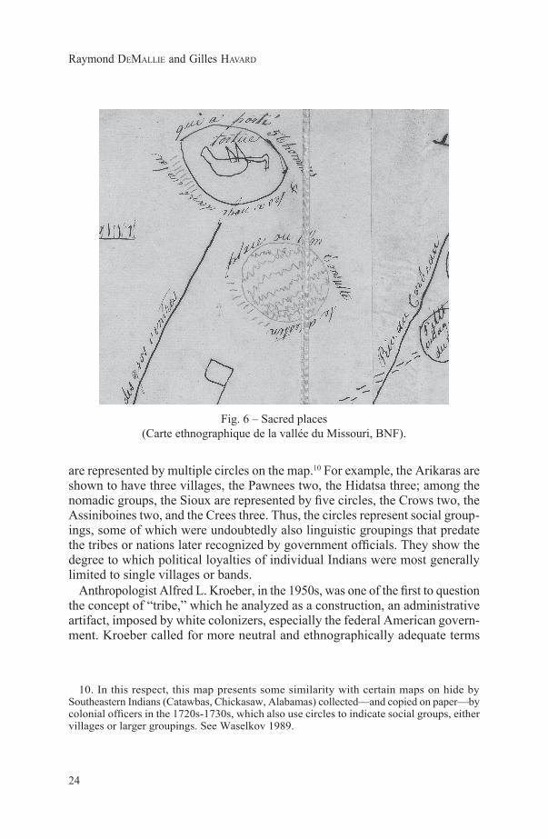
Village Chief’s country, centering on the Missouri River and the lands and peoples to the west, reflects the orientation of the Arikaras. In addition to physical space and social environment the map also depicts a number of sacred places. Two are near the Missouri, on the east side, but most are west of the river. Their hunting grounds and wintering places were to the west of their villages, and this was the area that they claimed as their own. It is significant that the map depicts relative locations of groups, not bounded areas. It is also significant that some groups that are conventionally thought of as tribes (i.e., sociopolitical units)
8. “Chicacha”; “Ris ou Ricara” perhaps an Arikara village name; “gens du castor”; “Pasquirara, gens qui portent sur la tête”; the fifth name seems to be “les gens du Chapeau.”
9. See Moulton 1987, p. 152-154. Gravelines accompanied Too-ne to Washington in 1805 and was involved in the mapmaking.
24
Raymond DeMallie and Gilles HavarD
are represented by multiple circles on the map.10 For example, the Arikaras are shown to have three villages, the Pawnees two, the Hidatsa three; among the nomadic groups, the Sioux are represented by five circles, the Crows two, the Assiniboines two, and the Crees three. Thus, the circles represent social group-ings, some of which were undoubtedly also linguistic groupings that predate the tribes or nations later recognized by government officials. They show the degree to which political loyalties of individual Indians were most generally limited to single villages or bands.
Anthropologist Alfred L. Kroeber, in the 1950s, was one of the first to question the concept of “tribe,” which he analyzed as a construction, an administrative artifact, imposed by white colonizers, especially the federal American govern-ment. Kroeber called for more neutral and ethnographically adequate terms
10. In this respect, this map presents some similarity with certain maps on hide by Southeastern Indians (Catawbas, Chickasaw, Alabamas) collected—and copied on paper—by colonial officers in the 1720s-1730s, which also use circles to indicate social groups, either villages or larger groupings. See Waselkov 1989.
Fig. 6 – Sacred places (Carte ethnographique de la vallée du Missouri, BNF).

25
Writing the history of North America from Indian country
like “band” and “village” (Kroeber 1955).11 Indeed, the term tribe (“tribu” in Latin and French) was first used to describe the American Indians during the seventeenth century by authors influenced by their classical and biblical culture, as we can see in French colonial documents12—even though the word nation (which meant in French political culture any group of people with common origin, or status, customs, lifestyle, etc., whatever their size; Durand 2001, p. 10-13) was generally favored by French officials over the term tribu to account for the Indian social world (see White 1991a, p. 16-17; Witgen 2012; Dubé 2013; Havard 2017 [2003], p. 99-100). Tribe was then popularized in the nineteenth century by social evolutionary anthropologists to designate the political organization of societies placed in a particular stage of development (barbarism). In any case, as other scholars have rightly stressed, this word is not an inside reality of Indian country. As the circles on the Arikara map make clear, the relevant social units are villages (among the sedentary groups) or bands (among the nomadic groups), rather than “tribes”—if by “tribes” we understand sociopolitical units related by kinship using a common ethnonym (see Albers and Kay 1987; DeMallie 1998).
Plains Indians’ conceptions of territory
The concept of tribe has led to much confusion, especially when each tribe has been associated with a specific territory with clear-cut boundaries. Village Chief’s map helps us overcome such simplifications. With this caution in mind, we can turn to documentation in the historical and ethnographic record from the late eighteenth through the early twentieth centuries.
As Village Chief’s map shows, the earth-lodge villages formed the foci for the sedentary peoples along the Missouri River. There the women had their gardens and the entire social group resided in the village during the planting and harvesting seasons. During the summer and fall, most of the people left on extended buffalo hunts, living in portable buffalo-hide tipis like those of the nomadic groups. Each village had its customary places for hunting buffalo and other animals, for trapping eagles, and other practical and religious activities. Twentieth-century ethnographers often asked elders to describe the limits of their territories in the past. Alfred W. Bowers provides a map of Hidatsa territory drawn in 1932 by Bear’s Arm, a member of Awaxawi village, that extends from somewhat below the Hidatsa villages near the mouth of the Heart River, up the Missouri to the Yellowstone, and whose boundaries form a rough parallelogram
11. For a critique of the notion of “tribe” in another area, the Great Lakes, see Hickerson 1982, p. 43; White 1991a, p. 16-17.
12. In French colonial writings, “tribu” could mean either village or clan. See Havard 2017 [2003], p. 98-99.

26
Raymond DeMallie and Gilles HavarD
drawn from mountains or buttes in the four corners encompassing much of the present state of North Dakota (Bowers 1992, p. 12). Hidatsas lived and hunted throughout this entire area at various times, but other Indian peoples did as well, including the Mandans, with whom the Hidatsas were (usually) at peace, and the Assiniboines and various Sioux groups, with whom they were (usually) at war. Bowers notes that members of other Hidatsa villages imagined their territory somewhat differently. It seems clear that boundaries were contested and changeable, and that ownership of land was conceptualized in terms of occupation and use, and validated by sacred sites tied to religious traditions.
The eastern Dakota living on the Mississippi River in Minnesota represent groups that occupied permanent village sites, but with less substantial bark lodges rather than more permanent earth lodges. A speech by a chief of the “Sioux des Lacs,” recorded in spring 1754 by the French officer Joseph Marin de La Malgue, speaks to the issue of territory. After smoking calumets, the assembled chiefs asked for pity because they had not been able to hunt during the past winter for fear of attacks by the Crees and Ojibwes. The orator said:
We also bring suit my father, concerning the fact that the Sauteux [Ojibwes] want to take our territory. Here is a map of the Mississippi. No one could be unaware that from the mouth of the Ouiskoinsin [Wisconsin River] to Sangsue Lake [Leech Lake], these territories belong to us. […] One can still see the marks of our bones, which are marks of the Cristinaux [Crees] and Sauteux having killed us. But they never ran us off that way. These are territories that we hold from no one except the Master of Life who gave them to us. […] They attacked us, my father, a total of twenty-eight times. But that, my father, did not keep us from making peace with the Sauteux when you ordered us to. And we allowed them to hunt in our territories. (Bailey 1975, p. 95; Champagne 1960-1961, p. 279-281, 303)
The Sioux lament is about power, with the assumption that the French have the power to control the actions of the Crees and Ojibwes. The orator supports his speech with a map, on which he shows Marin the extent of Dakotas’ territory centering on the upper Mississippi. The legitimacy of their claim to this country is primordial; it was a gift of “the Master of Life”—we can suppose this was a French translation of a Dakota term, perhaps Táku Wakháŋ “Something Holy.” The speech conceptualizes eastern Sioux territory as a social space defended by past wars and legitimized by the bones of ancestors slain by their enemies. The speech makes it clear that despite their claims to this territory, they did not preclude the Ojibwes from hunting there during those periods when peace was established between the two peoples—in the Great Lakes region, the sharing of hunting ter-ritories was sometimes referred to by the metaphor of the “common bowl” with a large ladle for everyone to “eat” the meat in it (see Havard 2001, p. 145-149).
By the end of the eighteenth century, the western Sioux were in control of the plains west of the Missouri from the Platte northward to the Grand. They

27
Writing the history of North America from Indian country
had come from the plains and prairies east of the Missouri, following the buf-falo. Two factors had ensured their success: the rapid acquisition of horses and the depopulation of the Arikara villages as a result of epidemic diseases (White 1978). They were middlemen in the trade of European goods, obtain-ing them from British traders on the Minnesota River and exchanging them for horses and horticultural products with the village peoples of the Upper Missouri. Whenever possible, they prevented white traders from going farther up the Missouri, not wanting them to supply guns and ammunition to their enemies and circumventing their position as middlemen. Thus, at the time when Lewis and Clark came up the Missouri, the western Sioux were at the height of their power. Their interaction with the Sioux exemplifies the difficulty of cross-cultural communication in situations in which there is little mutual understanding. The captains found the Yanktons welcoming but one of the Brulé Lakota chiefs was hostile and opposed to letting the expedition continue. Lewis attempted to explain to them that the Indians were now under the protection of the United States, and in recognition of that the first, second, and third chiefs of the Brulés were presented with medals and other tokens from their new Great Father. That was a white man’s custom with which they were already familiar, but the concept of US sovereignty over their country must have been so incomprehensible as to have made no impression (Moulton 1987, p. 16-35).
Writing of what he designated the “Great Sioux or Dacotah nation,” as they were when he first met them in 1833, fur trader Edwin Denig reported that they claimed the land in a vast area from Lac qui Parle in Minnesota, northwest to the head of the Pembina River, diagonally to the Missouri below the Hidatsa villages, up the Grand River west and south to the head of Powder River, along the mountains to Fort Laramie, down the Platte, then down the Niobrara to its juncture with the Missouri, down the Missouri to the mouth of the Big Sioux River, and then north to Lac qui Parle, including the Vermillion and James Rivers. Within this area, Denig reported, each of the various Sioux groups lived on particular river courses, although these were not exclusive territories (Denig 1961, p. 3, 15; Albers and Kay 1987; Greer 2012).
“We can hunt everywhere”: the misunderstandings of the 1851 Treaty of Fort Laramie
By 1840 white emigrants were traveling westward to Oregon or California following the trails along the Platte River that cut through the area where the Brulé and Oglala Lakotas lived. The emigrants caused far-reaching damage. They hunted buffalo not only for food but also for sport, driving the animals away; they cut wood for fires in a region where trees were scarce; their horses and cattle consumed the grass; and they brought with them epidemic diseases

28
Raymond DeMallie and Gilles HavarD
that spread with deadly effect among the Sioux and other Indian groups.13 With the beginning of the Mormon emigration to Utah in 1847, and with the discovery of gold in California the next year, traffic on the road increased exponentially. After the annexation of California and Oregon, the long-held idea of establishing a permanent Indian Territory in the west was abandoned (see White 1991b, p. 89-90). Instead, US government policy turned to individual land allotment and ultimate assimilation of the Indians into American society. In 1851, Congress appropriated funds to call together the Plains Indians to sign a treaty designed to impose a new order by establishing a general peace and drawing clear-cut boundaries between “national territories.”
Study of the documentary record as a means to reconstruct the Indians’ perspectives on the changing situation during the second half of the nineteenth century points to the 1851 treaty, held near Fort Laramie, as the beginning of the erosion of Indian control over their lands. Indian Superintendent David D. Mitchell and Indian Agent Thomas Fitzpatrick were assigned the task of conven-ing the council. Mitchell had been for many years a fur trader on the upper Missouri and Fitzpatrick had been a trapper and later a scout and guide. They enlisted the aid of Father Pierre Jean De Smet, the Jesuit missionary who was widely known and highly respected by the Indians, to help persuade them to attend the council. His influence was essential since the council was to be held at Fort Laramie, in an area where the Lakotas lived, who were long-time enemies of the Crows and other upper Missouri peoples (DeMallie 2014).
The provisions of the treaty were simple, but with far-reaching consequences. The Indians would pledge an end to warfare and to live in peace with one another and they would recognize the right of the United States to build military posts and roads in their territory. The US pledged to protect the Indians from depredations by its people and the Indians pledged to make restitution for any wrongs they might commit against people from the US “lawfully residing in or passing through their respective territories” (Kappler 1904, p. 594). To that end, each “nation” would acknowledge the boundaries of its specific territory. This was the first step toward establishing reservations and for the first time on the plains clearly differentiated Indian country from the rest of the United States. The treaty introduced the concept of boundaries that would divide the land into contiguous territories, and, moreover, defined “nations” as political entities, each to be represented by a head chief with the authority to transact “national business” such as signing treaties and negotiating disputes between tribal members and the government.
Representatives of eight “nations” attended the council, coming from the cen-tral and northern Plains (the southern Plains Indians—the Kiowas, Comanches,
13. W. H. Harvey, Superintendent of Indian Affairs, St. Louis, to Commissioner of Indian Affairs, May 6, 1846 (NARS Record Group 75, M234, roll 884, H 2279).

29
Writing the history of North America from Indian country
and Plains Apaches—refused to come so far north, into Lakota territory). The meetings of the council lasted ten days. Mitchell explained the issue of bounda-ries clearly, but in a manner that must have been entirely new to the Indians:
[I]t is proposed that your country shall be divided into geographical districts—that the country and its boundaries shall be designated by such rivers, mountains and lines, as will show what country each nation claims and where they are located.
He requested that each nation choose five or more head men to meet with the commissioners in a private session (at which no minutes were recorded) to decide the question of boundaries.
That meeting occupied a full day of discussion. Father De Smet had come to the council by way of Fort Union, and there the fur trader Edwin Denig, who had lived among the Indians of the upper Missouri for some twenty years and was married to an Assiniboine woman, provided the priest with a map he had drawn of Indian locations on the plains. This, together with the advice of the experienced trappers and traders who attended the council, served as the basis for discussion. The recorder of the council wrote only that, “After much consul tation, particularly of the Indians among themselves, the metes and bounds of the several nations were agreed upon.” The Cheyennes and Arapahos were assigned a joint territory, as were the Arikaras, Mandans, and Hidatsas; all the others were assigned separate territories.
However, controversy broke out the next morning when the council resumed and the terms of the argument reveal a good deal about Indian thought on the matter of land and boundaries. Black Hawk, an Oglala, expressed his dissat-isfaction: “Father, if there is anything I do know, it is this country, for I was raised in it, with the interpreters and traders.” It is significant that in talking about territoriality, Black Hawk makes a point of including the white men who were married to Indian women and their children. They were the only ones who might be able make the Indians understand what was at stake and make the commissioners understand the Indians’ objections. Black Hawk continued: “You have split the country, and I don’t like it.” The recorder reported that “much difficulty was experienced in explaining to the Sioux the extent and effect of the boundary designated between them and the Cheyennes and Arrapahoes. The Platte was fixed as the boundary, but the Sioux asserted their claim to both sides of the river.” That land use was based on power was a concept basic to Plains Indian cultures. Referring to the area south of the Platte, Black Hawk explained: “These lands once belonged to the Kiowas and Crows, but we whipped these nations out of them, and in this we did what the white men do when they want the lands of the Indians […] This last battle [with the Kiowas] was fought by the Cheyennes, Arrapahoes and Ogallahlahs combined, and the Ogallahlahs claim their share of the country.” The commissioners were confronted with the difference between the Euro-American concept of land ownership and the

30
Raymond DeMallie and Gilles HavarD
Indians’ conception of land use. Mitchell tried to avoid the matter by explaining that, “in fixing a boundary to their country, he had no purpose of limiting them to that boundary in hunting, or to prohibit them from going into the territory of any other Nation, so long as they remained at peace.” Yet, in future years, the boundaries set by the treaty would be interpreted by the government in terms of ownership.
During the same 1851 negotiations, one Brulé Lakota chief, Terre Blue, said that they did not really care about the territorial boundaries, because “we can hunt everywhere.”14 In 1865, in the same way, a group of US treaty commis-sioner attempted to determine the territorial boundaries of some of the Sioux groups. They asked Walking White Buffalo, a chief of the Brulé Lakota, “What land do you claim as belonging to the Brulé tribe?” He replied:
I have been travelling over the land from opposite Fort Randall, across to the Running Water, or Niobrara river, and Long Pine Tree river, and from there to Fort Kearney, on the Platte; then from there to Fort Laramie, and then to the head of Powder river and Pumpkin Hill, and from there to the Little Missouri, or Gros Ventres [Hidatsas], and from that down here. I have travelled all over that country15.
This describes a very large area, from the Missouri River into Wyoming and from northern Nebraska into North Dakota. By describing his travels, Walking White Buffalo avoided the question of boundaries. That question was not relevant to him.
The question of history: are the buffalo disappearing?
By 1851 the situation on the plains was rapidly changing. One of the major changes was the vanishing of the buffalo (Isenberg 2000). Following the treaty signed near Fort Laramie, Superintendent Mitchell observed:
The buffalo, on which they rely for food, clothing, shelter and traffic, are rapidly diminishing. In addition to their other misfortunes the hordes of emigrants passing through the country seem to have scattered death and disease in all directions […]. The introduction of all these evils they charge, and I suppose justly, upon the whites.16
After the Civil War, a series of peace commissions visited the upper Missouri to make new treaties. By then the Lakotas had to go farther from the Missouri to hunt and relied on the buffalo herds beyond the Black Hills in Wyoming and the Powder River region of Montana. An exchange recorded by the 1865 treaty commission illustrates the way in which the Lakotas conceptualized the land in
14. Missouri Republican, November 2, 1851.15. Proceedings, 1865, p. 33.16. Report of David D. Mitchell, ARCIA 1851, p. 324.

31
Writing the history of North America from Indian country
terms of the resources it offered—particularly buffalo—rather than as bounded places. The commissioners asked Lone Horn, head chief of the Minneconjou Lakotas: “Do you want to come and live near the [Missouri] river, where we can come and see you often?” Lone Horn replied: “When the buffalo comes close to the river, we come close to it. When the buffaloes go off, we go off after them.”17 This was a practical reply. The Lakotas were dependent on the buffalo, but by 1865 game was becoming scarce along the Missouri. The Lakotas continued to follow the diminishing herds westward, and by 1868 they were moving beyond the mouth of the Yellowstone, into Montana.18
The rapidity of the demise of the buffalo herds along the Missouri River and its tributaries in Dakota Territory and Nebraska was incomprehensible to the Indians. Writing of the Oglalas in the early nineteenth century, Edward Curtis commented: “So sudden was the disappearance [of the buffalo] that the Sioux regard their passing as wakáⁿ, mysterious. The old men still ask what became of them, and nothing can convince them that the herds have passed forever” (Curtis 1970 [1908], p. xxiii).
At the 1851 treaty council, the diminishing herds were the Indians’ central concern. Asking for reparations, a chief of the Blackfoot Lakota told the commis-sioners, “We think we should have a hundred wagon loads of goods every year, and more buffalo.” Wahata-uh, an Arikara chief, commented, “We will do the best we can to satisfy our Great Father. We hope he will send us more buffalo.”19 The request that the “Great Father” provide buffalo is echoed, for example, in the speech that Gut Fat, a Hunkpapa Lakota chief, made to the 1865 Treaty Commission: “When I heard that you had arrived here I thought I would come and see you, and hear from you that you were going to return us all the buffalo as it used to be, and we would have plenty of game, and the land would be good to live in.”20 In short, the Great Father should fix the problems caused by his white children, and be generous to the Indians, as every chief should be.
From the Indians’ perspective, the combined effects of travelers on the roads and steamboats on the Missouri were the reason for the scarcity of buffalo. Running Antelope, a Hunkpapa chief, told the 1865 Peace Commission, “When the Great Spirit made me and my people and put us on this land, he made the buffalo for us and placed the buffalo here.” Several speakers repeated the same moral and spiritual justification for their relationship with the buffalo. Many leaders spoke of the white men scaring away the buffalo. In addition to whites scaring off the buffalo, the Indians were facing competition from the Red
17. Proceedings, 1865, p. 34.18. Bvt. Brig. Gen. Henry A Morrow, Ft. Buford, to Acting Adjutant General, Department
of Dakota, Sept. 8, 1869. Letters Sent, Fort Buford, 1869, No. 144 (NARS Record Group 393).19. Missouri Republican, November 2, 1851; and October 8, 1851.20. Proceedings, 1865, p. 104.

32
Raymond DeMallie and Gilles HavarD
River Métis, who were organizing massive buffalo hunts. Long Mandan, the Two Kettle chief, pleaded with the commissioners: “The half-breeds from the north stop the buffalo from coming to our country. I wish you would get our Great Father to stop all this.”21 Spotted Tail told the 1867 peace commissioners: “The Country in which we live is cut up [i.e., “cut up” by roads] by the white men, who drive away all the game.”22 However, the problem was not insoluble. Bull Owl, a Hunkpapa, told the commissioners in 1868: “We don’t like to have the whites traveling through our country and bringing steamboats up our river. I hope you will stop this, so that the buffalo will come back again.”23
In an attempt to explain the Lakotas’ perspective, Little Bear told the commis-sioners in 1865: “The Great Spirit and his wife were made first, then these Indian nations were made. When He made them He gave them the buffalo and the pipe.” Here Little Bear manipulates the most potent symbols of Lakota religious belief: the creation of everything by Wakháŋ Tháŋka, and the gift of the sacred pipe, symbolizing the covenant between the Lakotas and the buffalo, making the land uniquely Lakota. But in response the commissioners developed a counter-argument, as articulated by General C. C. Curtis: “The President thinks the Great Spirit made the land and the buffalo for the white men and the red man. This is not exclusively your land. It belongs to men of all nations.”24 The symbolic manipulation shifts the argument in a new direction, again underlining the cultural differences between whites and Indians.
The undeniable fact of the shrinking buffalo herds was indeed understood very differently on either side of the cultural frontier. In his 1859 annual report, Indian Agent Thomas Twiss noted that “the condition of things [is] now in process of rapid development, which threaten[s] the utter extinction of the wild tribes, by destroying the game on which they depend for subsistence.”25 Twiss, like other frontiersmen, realized that the only hope for the Indians to escape the same fate as the buffalo was to adapt an agricultural style of life. Indians—as represented by the Sioux—saw the situation differently. If the buffalo were missing, they must have gone somewhere. That is the basis for the belief that if the whites stopped traveling the roads and discontinued the steamboats on the Missouri, the buffalo would return. No one, white or Indian, could doubt the reality of the diminishing numbers, but, in cultural terms, they saw the facts differently. For the Sioux, their reliance on the buffalo was a sacred pact, sealed by the gift of the Buffalo Calf Pipe by White Buffalo Woman. Buffalo
21. Proceedings, 1865, p. 101, 125.22. Minutes and Proceedings of the Indian Peace Commission Appointed by an Act of
Congress Approved July 20, 1867, RG 48, NARS.23. Report of the Indian Peace Commission, 1868, RG 48, NARS.24. Ibid., p. 74, 96.25. ARCIA 1859, p. 498.

33
Writing the history of North America from Indian country
originated within the earth and could just as easily return there. Explanations abounded. For example, Two Lances, a Two Kettle Lakota leader, told the 1865 commissioners that buffalo would not come near the white men’s roads.26 Agent Twiss reported the Indian belief that buffalo would not return to a place where they had scented white men.27
The question of race, or the rise of the mixed bloods
The process of colonial “territorialization” of Indian country has to be consid-ered in relation to the process of racialization of identities. Again, this process must not to be seen as inevitable, but it needs to be historicized so that we avoid projecting Euro-American categories on Indians’ actions. Contrary to what happened in the Red River area with the “Bois Brûlés,” where a new people emerged as a product of both intermarriage between white fur traders and Indian women (mostly Cree, Assiniboine, and Ojibwe) and specific social practices, no process of ethnogenesis occurred in the Missouri Valley (see Thorne 1996).28 To better understand this difference, it is worth investigating the perspectives of the Indians in that region on the children of white and Indian descent. To what extent, and when, did Indian peoples begin to consider children of mixed descent as a distinct social category?
William Clark, during his visit to the Mandans in 1804, relates that when a “half white” child miraculously escaped a prairie fire by hiding under a bison hide, “Those ignerent [sic] people Say this boy was saved by the great spirit medisin [sic] because he was white” (Clark, 29 October 1804, in Moulton 1987, p. 209, 211). This is congruent with the fact that Plains Indians interpreted human accomplishments as concrete evidence of spiritual powers, and that the whites were generally recognized as having some exceptional powers. But what about métissage properly? When visiting the Mandan villages in 1810, the Scottish naturalist John Bradbury recounts that chief She-he-ké “pointed to a little boy in the lodge, whom we had not before noticed, and gave us to understand that his father was one of the party that accompanied Mr. Lewis [in 1804]” (Bradbury 1904, v. 5, p. 164). It would seem that the boy’s invisibility was an indication that Plains Indians did not then envision the “mixed bloods” as a distinct category. Indeed, Indians did not calculate identity on the basis of hereditary traits, whether blood or other corporal fluids, but rather reckoned kinship independently from consanguinity. Symbolically, the Arikaras provide a good example: their term for mixed bloods is piiratariinat “stitched body,”
26. Proceedings, 1865, p. 62.27. ARCIA 1859, p. 407. For further discussion of Lakota perspectives on the buffalo,
see DeMallie 1982.28. The same can be said for the Great Lakes, see Peterson 2012.

34
Raymond DeMallie and Gilles HavarD
a union of two parts (see DeMallie 1994; Désveaux 2001, p. 484-488; see also Havard 2016, p. 717-728).
Over time it would be the children of the white traders who would be called on to mediate for their mothers’ people. A common Sioux designation for mixed bloods was wašícuŋ chiŋcá “Frenchmen’s children,” emphasizing their relation-ship to their father’s people, while the Yanktons also used the term Dakhóta chiŋcá “Indian children,” emphasizing their relationship to their mother’s people. The Lakotas came to call them iyéska “interpreters,” a term that referred to their social role. It seems that “half-breeds”—at least those who were raised both by their white fathers and Indian mothers—were seen in a special light by Indians and whites alike because of their linguistic and social abilities. As is made clear in the speech by Smutty Bear, a Yankton chief who addressed the US commissioners during the 1851 Fort Laramie council, the category of mixed blood was defined in terms not of hybridity, but rather of mediation: “Father, this is the third time I have met the whites. We don’t understand their manners, nor their words. We know it is all very good, and for our good, but we don’t understand it all. We suppose the half-breeds understand it, and we leave them to speak for us.”29 By that time, both Indians and whites on the Upper Missouri considered “half-breeds” to be a distinctive type of person. They had become a visible minority, whether characterized by their physical traits—as Europeans did usually do—or by their specific social behavior.
The link between territorialization and racialization is made clear by the policy of establishing “half-breed tracts.” At the conclusion of the 1851 treaty council, following the ceremony of signing, “the traders, Interpreters, and oth-ers having Indian wives, and half breed children” proposed that a portion of country should be set apart for the future use of the half breeds. The measure was encouraged by the treaty commissioners. This policy was not new, as some tracts had been created in the Lower Missouri Valley in previous years in an effort to civilize or de-indianize the white traders, their Indian spouses, and their offspring.30 Superintendent Mitchell explained the idea to the commissioner of Indian affairs as follows:
Hard necessity will soon compel them [the Plains Indians] to change their mode of life or perish. As a means of turning their attention to agricultural and grazing pursuits I would recommend that a suitable section of the country, somewhere on the Missouri or its tributaries, be assigned to the half-breeds, who are becoming very numerous throughout the Indian country. The father of most of these half-breeds are still living, and residing in the country with their families. […] A half-breed colony,
29. Missouri Republican, November 2, 1851.30. The Nemaha Half-Breed Reserve, created by the Prairie du Chien treaty of 1830, was
for “half-breeds” of French-Canadian and Indian (Omahas, Iowas, Oto-Missouris, Yanktons, and Santees) ancestry. See Thorne 1996, p. 141-148, 214-219.

35
Writing the history of North America from Indian country
properly located in the midst of the Indians, would form a semi-civilized nucleus around which the wild Indians would soon be drawn by necessity to assemble.31
According to the recorder of the 1851 treaty, the Indians were favorable to the idea of a half-breed reserve but it foundered on the refusal of the Cheyennes and Arapahos to give up the agricultural lands requested “at the base of the mountains” (in Colorado).32 Nonetheless, the discussion may be seen as rec-ognition of the mixed bloods as a distinct social category.
During the 1868 treaty council at Fort Laramie, the mixed-blood question again was brought up, with the commissioners proposing that they be moved to a half-breed reservation on the Missouri River. But Man Afraid of Horses, the leading Oglala chief, objected, insisting that he wanted the mixed bloods to stay with the Indians. “I want the half-breeds to take care of this land,” he said, then called forward representatives to speak for themselves. They did not want to go to a separate reservation. John Richards, Jr., spoke: “I was raised here; I do not want to go to the Missouri Reservation, on the part of the half breeds, I come forward to say this.” “Joseph Bissonnette and others declared that they did share in these sentiments.”
Man Afraid of Horses continued: “All the fathers of the half breeds have been raised around here, and it is for the children that I am now talking. I want the women and children to take care of this land for me.”33 Man Afraid of Horses was keenly aware of the utility of the mixed bloods and their capacity as mediators. At the same time, he reflected traditional ways of understanding social relations: the wašícuŋ chiŋcá were relatives and the racial factor was irrelevant to him. For him, the markers of identity were not descent, blood, or race, but social behavior and language. Arikara chief Le Bouclier Blanc said quite the same thing in 1867 to Philippe-Régis-Denis de Keredern de Trobriand, a French colonel in the US Army: “Skin color does not make a difference; […] My skin is red; but my grand-father was a white man. Who cares? It’s not my skin color which makes me good or bad.” Skin color was a visible feature, but not one that was relevant to social identity.34
Nevertheless, the Indians did not escape the racialization of social rela-tions, especially when they were restricted to reservations (see Biolsi 1995; DeMallie 2009). The Yanktons even established a “halfbreed” (“white man’s children”) band in 1866, reflecting the increasing number of mixed-blood families in which the non-Indian father either died or abandoned his family. The chief of the band was François Deslauriers (DeMallie 2013), who told
31. ARCIA 1851, p. 325.32. Missouri Republican, November 30, 1851.33. “Report of the Indian Peace Commission,” 1868, NARS.34. Our translation from the French: Trobriand 1926, p. 110-111. See also Hogues 2012;
Havard 2013.

36
Raymond DeMallie and Gilles HavarD
the 1867 treaty commissioners: “I was raised in this nation. I love the whites. Half of me belongs to this nation, and half to the whites.”35 While the “half-breed” band occupied a specific portion of the Yankton Reservation and participated in reservation political life, it does not seem to have had a place in the Yankton camp circle as did the other seven bands.
* * *
Ethnohistorical study of Indian countries compels us to reconsider our ana-lytical framework of social concepts and classifications. Indeed, from Indian countries we learn that some categories that seem natural to Euro-Americans, such as tribe or nation, chief, war and peace, race, and métissage, were not universal in North America during the eighteenth and nineteenth centuries, and that they need to be historicized. Race was not a relevant factor for Plains Indians when Lewis and Clark, in the wake of French-Canadian or “Creole” traders and hunters, visited the Upper Missouri villages. It only become such when Indian country was territorialized by the US. In this regard, the colonial conquest was not only territorial but was also a way in which new social mean-ings and practices were created. The transformation of Indian country from a place peopled by sovereign Indians to a country under US rule and divided into reservations seems inseparable from the racialization process.
White intrusion into Indian countries forced the Indians themselves to adopt the idea of Indian country by contrasting it with the colonized zones along their border. Eventually, the demise of Indian country and its replacement by multiple scattered reservations was paralleled by the rise of the racial dichotomy between full bloods and mixed bloods (understood here mainly as social categories). As the mixed bloods sought to emulate white American economic and social practices, abandoning traditional Indian culture, the symbolic divide between full bloods and mixed bloods deepened. On the Lakota reservations, at least, the mixed bloods had to a large degree dissociated themselves from the full bloods, but after the Indian Reorganization Act in 1934, the mixed bloods were reincorporated into the political entities of the reservation “tribes” and animos-ity between them and the full bloods became institutionalized in reservation culture and is today a major dynamic invested with many layers of meaning in Indian country. Yet despite the trauma of the conquest and cultural disposses-sion, Indian country—including the reservations in Nebraska, South Dakota, and North Dakota—have remained places where native cultures are preserved, perpetuated, and adapted to the ever-changing modern world. *
* Manuscrit reçu en septembre 2017, accepté pour publication en novembre 2018.
35. “Transcript of the Minutes and Proceedings of the Indian Peace Commission Appointed by an Act of Congress Approved July 20, 1867,” R.G., 48, NARS, vol. 1, p. 65.

37
Writing the history of North America from Indian country
References cited
ARCIA = Annual Report of the Commissioner of Indian Affairs, Washington (DC).BNF = Bibliothèque nationale de France.NRAS = National Archives Records and Administration Services.Proceedings = Proceedings of a Board of Commissioners to Negotiate a Treaty or
Treaties with the Hostile Indians of the Upper Missouri, Government Printing Office, Washington (DC), 1865.
* * *
albers Patricia and Jeanne Kay
1987 “Sharing the land: a study in American Indian territoriality”, in Thomas E. Ross and Tyrel G. Moore (eds.), A cultural geography of North American Indians, Westview Press, Boulder, p. 47-91.
bailey Kenneth P. (trans. and ed.)1975 Journal of Joseph Marin, privately published.barr Juliana2001 “Geographies of power: mapping Indian borders in the ‘Borderlands’ of the
Early Southwest”, William and Mary Quarterly, 66 (1), p. 5-46.2012 “The red continent and the cant of the coastine”, William and Mary Quarterly,
69 (3), p. 521-526.beattie Judith Hudson1985-1986 “Indian maps in the Hudson’s Bay Company archives: a comparison of five
area maps recorded by Peter Fidler, 1801-1802,” Archivaria, 21, p. 166-175.binneMa Ted2001 “How does a map mean. Old Swan’s map of 1801 and the Blackfoot World,” in
R. C. Macleod, Theodore Binnema, and Gerhard J. Ens (eds.), From Rupert’s Land to Canada. Essays in honour of John E. Foster, University of Alberta Press, Edmonton, chap. 10.
biolsi Thomas1995 “The birth of the reservation: making the modern individual among the
Lakota”, American Ethnologist, 22 (1), p. 28-53.bowers Alfred1992 Hidatsa social and ceremonial organization, University of Nebraska Press,
Lincoln.braDbury John1904 “Travels in the Interior of America”, in Reuben G. Thwaites (ed.), Early
Western travels, 1748-1846, Arthur H. Clark Company, Cleveland, vol. 5.CHaMpagne Antoine (ed.)1960-1961 “Journal de Marin fils, 1753-1754”, in Rapport de l’archiviste de la
Province de Québec, 41.Curtis Edward S.1970 [1908] North American Indian, Johnson Reprint, New York, vol. 5.

38
Raymond DeMallie and Gilles HavarD
DeMallie Raymond J.1982 “The Lakota ghost dance: an ethnohistorical account,” Pacific Historical
Quarterly, 51 (4), p. 385-405.1994 “Kinship and biology in Lakota culture”, in Raymond J. DeMallie and Alfonso
Ortiz (eds.), North American Indian anthropology. Essays on society and culture, University of Oklahoma Press, Norman, p. 125-146.
1998 “Kinship: the foundation for Native American society”, in Russell Thornton (ed.), Studying Native America. Problems and prospects, University of Wisconsin Press, Madison, p. 306-356.
2009 “Community in Native America: continuity and change among the Sioux”, Journal de la Société des américanistes, 95 (1), p. 185-205.
2013 “De Deslauriers à Deloria: l’identité française d’une famille sioux”, in Gilles Havard and Mickaël Augeron (eds.), Un continent en partage. Cinq siècles de rencontres entre Amérindiens et Français, Les Indes savantes, Paris, p. 535-558.
2014 “The Great Treaty Council at Horse Creek”, in Suzan Harjo (ed.), Nation to Nation. Treaties between the United States and American Indian Nations, Smithsonian Books, Washington (DC).
Denig Edwin Thompson1961 Five Indian tribes of the Upper Missouri, John C. Ewers (ed.), University of
Oklahoma Press, Norman.Desbarats Catherine and Allan greer
2011 “Où est la Nouvelle-France?”, Revue d’histoire de l’Amérique française, 64 (3-4), p. 31-62.
Désveaux Emmanuel2001 Quadratura Americana. Essai d’anthropologie lévi-straussienne, Georg, Genève.Dubé Alexandre2013 “Les Amérindiens sous le regard des bureaux de la Marine (1660-1760).
Quelques pistes de réflexion sur un objet administratif”, in Gilles Havard and Mickaël Augeron (eds.), Un continent en partage. Cinq siècles de rencontres entre Amérindiens et Français, Les Indes savantes, Paris, p. 153-175.
DuranD Yves2001 L’Ordre du monde. Idéal politique et valeurs sociales en France du xvie au
xviiie siècle, SEDES, Paris.Duval Kathleen2007 The Native Ground. Indians and Colonists in the Heart of the Continent,
University of Pennsylvania Press, Philadelphia.greer Allan2012 “Commons and enclosure in the colonization of North America,” American
Historical Review, 117 (2), p. 365-386.HäMäläinen Pekka2008 The Comanche Empire, Yale University Press, New Haven.HäMäläinen Pekka and Samuel truett
2011 “On Borderlands,” Journal of American History, 98, p. 338-361.

39
Writing the history of North America from Indian country
HavarD Gilles2001 The Great Peace of Montreal of 1701. French-Native diplomacy in the
Seventeenth Century, McGill-Queen’s University Press, Montreal.2013 “L’héritage français des Arikaras. Histoire et mémoire,” in Gilles Havard and
Mickaël Augeron, (eds.), Un continent en partage. Cinq siècles de rencontres entre Amérindiens et Français, Les Indes savantes, Paris, p. 559-588.
2016 Histoire des coureurs de bois. Amérique du Nord, 1600-1840, Les Indes savantes, Paris.
2017 [2003] Empire et métissages. Indiens et Français dans le Pays d’en haut, 1660-1715, Septentrion, Sillery.
HiCKerson Harold1982 The Chippewa and their neighbors. A study in ethnohistory, Irvington Publ.
Inc, New York.Hogues Michel2012 “The Montana metis and the shifting boundaries of belonging”, in Nicole
St-Onge, Carolyn Podruchny, and Brenda MacDougall (eds.), Contours of a people. Métis family, mobility, and history, University of Oklahoma Press, Norman, p. 300-330.
isenberg Andrew C.2000 The destruction of the Bison. An environmental history, 1750-1920, Cambridge
University Press, Cambridge.Kappler Charles J.1904 Indian affairs. Laws and treaties. Vol. II. Treaties, Government Printing
Office, Washington (DC).Kroeber Alfred L.1955 “Nature of the land-holding group,” Ethnohistory, 2 (4), p. 303-314.litalien Raymonde, Jean-François paloMino, and Denis vaugeois (eds.)2008 La mesure d’un continent. Atlas historique de l’Amérique du Nord, 1492-1814,
Septentrion, Sillery.Masson Rodrigue L. (ed.)1960 Les bourgeois de la Compagnie du Nord-Ouest. Récits de voyages, lettres
et rapports inédits relatifs au Nord-Ouest canadien, Antiquarian Press, New York, 2 vol.
Moulton Gary E. (ed.)1987 The definitive journals of Lewis & Clark, University of Nebraska Press,
Lincoln, vol. 3.parKer John (ed.)1976 The journals of Jonathan Carver and related documents, 1766-1770, Minnesota
Historical Society, [St. Paul].peterson Jacqueline2012 “Red River Redux: métis ethnogenesis and the Great Lakes region,” in Nicole
St-Onge, Carolyn Podruchny, and Brenda MacDougall (eds.), Contours of a people. Métis family, mobility, and history, University of Oklahoma Press, Norman, p. 3-21.

Raymond DeMallie and Gilles HavarD
riCHter Daniel K.2001 Facing East from Indian country. A native history of Early America, Harvard
University Press, Cambridge and London.rountree Helen C.2005 Pocahontas, Powhatan, Opechancanough. Three Indian lives changed by
Jamestown, University of Virginia Press, Charlottesville.steinKe Christopher2014 “‘Here is my country’: Too Né’s map of Lewis and Clark in the Great Plains”,
William and Mary Quarterly, 71 (4), p. 589-611.tHorne Tanis1996 The many hands of my relations. French and Indians on the Lower Missouri,
University of Missouri Press, Columbia.trobrianD Régis de1926 Vie militaire dans le Dakota. Notes et souvenirs (1867-1869), H. Champion,
Paris.waselKov Gregory1989 “Indian maps of the Colonial Southeast”, in Peter H. Wood, Gregory A.
Waselkov, and M. Thomas Hatley (eds.), Powhatan’s mantle Indians in the Colonial Southeast, University of Nebraska Press, Lincoln, p. 292-343.
wHite Richard1978 “The winning of the West: the expansion of the Western Sioux in the
Eighteenth and Nineteenth Centuries,” The Journal of American History, 65 (2), p. 319-343.
1991a The middle ground. Indians, Empires and Republics in the Great Lakes Region, 1650-1815, Cambridge University Press, Cambridge.
1991b “It’s your misfortune and none of my own.” A new history of the American West, University of Oklahoma Press, Norman.
witgen Michael2012 An infinity of nations. How the Native World shaped Early North America,
University of Pennsylvania Press, Philadelphia.