
Woronora Estuary - Sutherland Shire ·...
135
Transcript of Woronora Estuary - Sutherland Shire ·...

K:\N0972_WORONORA_RIVER_EPS&EMS&EMP\DOCS\FINALEMS&EMP\R.N0972.002.01.EMS&EMP_FINAL.DOC 22/2/08 17:02
Woronora Estuary Management Study and Plan
Prepared For: Sutherland Shire Council
Prepared By: WBM Pty Ltd (Member of the BMT group of companies)
Offices
BrisbaneDenver
KarrathaMelbourne
MorwellNewcastle
PerthSydney
Vancouver

K:\N0972_WORONORA_RIVER_EPS&EMS&EMP\DOCS\FINALEMS&EMP\R.N0972.002.01.EMS&EMP_FINAL.DOC 22/2/08 17:02
DOCUMENT CONTROL SHEET
Document :
Project Manager :
R.N0972.002.01.EMS&EMP_Final.doc
Philip Haines
WBM Pty LtdNewcastle Office:
126 Belford StreetBROADMEADOW NSW 2292Australia
PO Box 266Broadmeadow NSW 2292
Telephone (02) 4940 8882Facsimile (02) 4940 8887www.wbmpl.com.au
ABN 54 010 830 421 003
Client :
Client Contact:
Client Reference
Sutherland Shire Council
Gwyn Cleeves
Title : Woronora Estuary Management Plan
Author : David Wainwright/Michelle Fletcher
Synopsis : This document has been prepared in accordance with the NSW Estuary Management Manual. It outlines the management process that is to be followed in order to achieve long-term sustainability of the Woronora Estuary with regard to ecological, economicand social values. The Plan is intended to be used by Council to guide future works programs and policy changes.
REVISION/CHECKING HISTORY
REVISION
NUMBER
DATE OF ISSUE CHECKED BY ISSUED BY
0
1
2
3
03/05/06
03/05/06
24/05/06
22/02/06
PEH
PEH
PEH
PEH
DJW
DJW
DJW
DJW
DISTRIBUTION
DESTINATION REVISION
0 – Draft 1 – Final Draft 2 – Exhibition 3 – Final
Sutherland Shire Council
WBM File
WBM Library
6 (1 Unbound)
1
1 - Electronic 1-Electronic/CD 20 + 1 Unbound
CONTENTS I
K:\N0972_WORONORA_RIVER_EPS&EMS&EMP\DOCS\FINALEMS&EMP\R.N0972.002.01.EMS&EMP_FINAL.DOC 22/2/08 17:02
CONTENTS
Contents i
List of Figures v
List of Tables v
1 PREAMBLE 1
1.1 Introduction 1
1.2 Study Setting 1
1.3 The NSW Government Estuary Management Framework 3
1.4 Structure of this Report 3
1.5 Membership of the Woronora Estuary Management Committee 6
2 PREVIOUS INVESTIGATIONS 7
2.1 Previous scientific investigations 7
2.1.1 The catchment 7
2.1.2 Tides 7
2.1.3 Freshwater flows 8
2.1.4 Waves 8
2.1.5 Water quality considerations 8
2.1.6 Sediment properties 9
2.1.7 Dredging 9
2.1.8 Sediment transport 9
2.1.9 Bank condition 10
2.1.10 Ecology 10
2.1.11 Human Uses 11
2.1.12 Heritage 11
2.2 Community and Stakeholder Consultation 11
2.2.1 Newsletter 1 and Questionnaire 12
2.2.1.1 Results of Questionnaire 12
2.2.2 Stakeholder consultation 14
2.2.3 Newsletter 2 15
3 VALUES AND ISSUES FOR FUTURE MANAGEMENT 16

CONTENTS II
K:\N0972_WORONORA_RIVER_EPS&EMS&EMP\DOCS\FINALEMS&EMP\R.N0972.002.01.EMS&EMP_FINAL.DOC 22/2/08 17:02
3.1 Introduction 16
3.2 National, state and regional significance of the Estuary 16
3.3 Values of the Estuary 17
3.3.1 Introduction 17
3.3.2 Threats to estuary values 17
3.4 Present uses and conflicts 18
3.4.1 Land use 18
3.4.1.1 Historical and present land use 18
3.4.1.2 Road access 18
3.4.1.3 Shackels Estate Acquisition Program 19
3.4.1.4 Waterway and Foreshore Usage 20
3.4.2 Human impacts and conflicts 23
3.5 Management Issues 25
3.5.1 Water quality 25
3.5.1.1 Issue A: Unsuitable water quality conditions 25
3.5.2 Ecology 25
3.5.2.1 Issue B: Decline in saltmarsh and seagrass 25
3.5.2.2 Issue C: Interruptions to fish passage 25
3.5.2.3 Issue D: Potential decline in wader bird species and numbers 25
3.5.2.4 Issue E: Weed invasion of riparian areas 26
3.5.3 Sedimentation 26
3.5.3.1 Issue F: Bank Erosion 26
3.5.3.2 Issue G: Unfavourable conditions for Navigation 26
3.5.4 Information gaps 26
3.5.4.1 Issue H: Gaps in existing knowledge 26
4 PLANNING AND CONSENT REQUIREMENTS 27
4.1 Relevant NSW Parliamentary Acts 27
4.2 Commonwealth legislation 30
4.3 Other important planning documents, policies and initiatives 30
4.3.1 Georges River Regional Environmental Plan 30
4.3.2 Sutherland Shire Council Local Environmental Plan, 2006 31
4.3.2.1 Zoning 31
4.3.2.2 Development potential 33
4.3.3 Development Control Plans 34
4.3.3.1 Sutherland Shire Environmental Site Management DCP 34
4.3.3.2 Sutherland Shire Dredging Waterways DCP (SSC, 2002) 34
4.3.3.3 Sutherland Shire Waterfront Development DCP (SSC, 2002) 35
CONTENTS III
K:\N0972_WORONORA_RIVER_EPS&EMS&EMP\DOCS\FINALEMS&EMP\R.N0972.002.01.EMS&EMP_FINAL.DOC 22/2/08 17:02
4.3.4 Catchment Action Plan 36
4.3.5 Healthy Rivers Commission Independent Inquiry 37
5 GOALS AND OBJECTIVES FOR FUTURE MANAGEMENT 39
5.1 Water quality objectives 39
5.2 Ecology objectives 40
5.3 Waterway and foreshore use objectives 40
5.4 Monitoring and evaluation objectives 41
5.5 Prioritisation of management objectives 41
6 DEVELOPMENT, ASSESSMENT AND PRIORITISATION OF POSSIBLE
MANAGEMENT OPTIONS/STRATEGIES 43
6.1 Formulation of Management Options / Strategies 43
6.1.1 Strategies addressing Water Quality Objectives (Objectives 1 to 5) 43
6.1.2 Strategies addressing Ecological Objectives (Objectives 6 to 10) 44
6.1.3 Strategies addressing Waterway and Foreshores Objectives (Objectives 11 to 15) 44
6.1.4 Strategies addressing Monitoring and Evaluation Objectives (Objectives 16 to 19) 46
6.2 Assessment and prioritisation of possible management options 46
6.2.1 Results of the multi criteria assessment 47
6.2.2 Short-list of preferred management options / strategies 49
7 WORONORA ESTUARY MANAGEMENT PLAN 53
7.1 Strategy Implementation Order 53
7.2 Implementation Schedules 54
7.2.1 Ecol-6: Revegetation / Protection of Eroding Foreshores 56
7.2.2 Ecol-0: Mapping and monitoring of ecological communities 60
7.2.3 M&E-4: Hydrosurvey monitoring 65
7.2.4 M&E-2: Water Quality Monitoring 67
7.2.5 Ecol-5: Mark key habitat areas on signs at recreational access points and with marker buoys 69
7.2.6 Ecol-11: Community education program on ecology and heritage 70
7.2.7 Ecol-2: Bushcare Groups: Revegetate areas close to ecologically sensitive areas 72
7.2.8 Ecol-4: Shackels Estate Bush Regeneration 73
7.2.9 W&F-9: Hard protection/repair of eroding foreshores 75
7.2.10 WQ-9: Review/revise stormwater policy considering erodibility of soils within catchment 77

CONTENTS IV
K:\N0972_WORONORA_RIVER_EPS&EMS&EMP\DOCS\FINALEMS&EMP\R.N0972.002.01.EMS&EMP_FINAL.DOC 22/2/08 17:02
7.2.11 W&F-14: Community campaign for clean-up / restoration of foreshores 78
7.2.12 W&F-2: Limited navigation dredging, as-required 79
7.2.13 WQ-4: Modifications to stormwater system including end-of-pipe treatment81
7.2.14 WQ-8: Assess and upgrade sewerage system to minimise overflows 84
7.2.15 W&F-0: General boating restrictions 87
7.2.16 W&F-7: More frequent and effective policing of waterway users 90
7.2.17 W&F-4: Provide information on the effects of speeding 92
7.2.18 M&E-1: Undertake survey on recreational fishing 94
7.2.19 Ecol-3: Ensure that Woronora Estuary is considered during Environmental Flow determination 95
7.2.20 Ecol-8: Modify planning instruments to provide for landward migration of saltmarsh communities 96
7.2.21 WQ-5: Locate and monitor all on-site sewage systems 97
7.2.22 WQ-1: Emergency Plan for illegal dumping / pollution events 98
7.3 Funding of the Plan 100
7.3.1 Funding requirements 100
7.3.2 Possible funding sources 100
7.3.2.1 Estuary Management Program 101
7.3.2.2 Sydney Metro Catchment Management Authority 101
7.3.2.3 Environmental Grants Programs 101
7.4 Accommodating Future Climate Change 103
7.4.1 Background 103
7.4.2 Predicted Changes Associated with the Enhanced Greenhouse Effect 105
7.4.3 Impacts of Climate Change on Woronora Estuary 106
7.4.4 Planning Considerations for Future Climate Change in the Woronora Estuary 107
7.5 Monitoring, Evaluation and Amendments 108
7.5.1 Monitoring of Plan Success 109
7.5.1.1 Primary Evaluation Measures 109
7.5.1.2 Secondary Evaluation Measures 110
7.5.1.3 Tertiary Evaluation Measures 110
7.5.1.4 Reviews and Amendments 111
7.5.2 Amendment Record 112
8 REFERENCES 113
APPENDIX A: RESULTS OF MULTI CRITERIA ASSESSMENT A-1

LIST OF FIGURES V
K:\N0972_WORONORA_RIVER_EPS&EMS&EMP\DOCS\FINALEMS&EMP\R.N0972.002.01.EMS&EMP_FINAL.DOC 22/2/08 17:02
APPENDIX B: COMMUNITY CONSULTATION B-1
LIST OF FIGURES
Figure 1-1 Features of the Woronora Estuary and its Catchment 2
Figure 1-2 Schematic outline of process for developing management strategies 4
Figure 1-3 NSW Government’s Estuary Management Process 5
Figure 2-1 Activities undertaken on the estuary by respondents 13
Figure 2-2 Ranking of selected estuary values by respondents 13
Figure 2-3 Ranking of issues by respondents 14
Figure 3-1 Location of Shackels Estate 20
Figure 4-1 Present catchment landuse zonings 32
Figure 4-2 The process involved in applying for development consent below MHWM for the Worornora Estuary (Source: Sutherand Shire Council, 2002) 36
Figure 6-1 Relative Score for Possible Management Options 48
Figure 7-1 Foreshore Erosion Areas: Northern Woronora Estuary 58
Figure 7-2 Foreshore Erosion Areas: Southern Woronora Estuary 59
Figure 7-3 Distribution of estuarine vegetation in the fluvial delta geomorphologic zone, Woronora Estuary 61
Figure 7-4 Distribution of estuarine vegetation in the riverine and channel geomorphologic zone, Woronora Estuary Sources: Pickthall et al. 2004 (saltmarsh and Casuarina), WBM (mangroves) current study 62
Figure 7-5 Sub-catchments and existing treatment devices for the Woronora River Estuary 82
Figure 7-6 Extract from NSW Maritime Boating Map 88
Figure 7-7 Australian average temperature variation, 1910 – 2005 compared to 1961-1990 average (Source: BoM, 2006) 104
LIST OF TABLES
Table 1-1 Members of the Woronora Estuary Managment Committee (as of Dec. 2006) 6
Table 3-1 Estuary side Reserves and facilities (Source: modified from SSEC, 2003)22
Table 3-2 Identified impacts of human activities on estuarine processes 24
Table 4-1 Implications of NSW Legislation for the development of management options for the Worornora Estuary 28
Table 5-1 Prioritised ranking of Management Objectives 42
Table 6-1 Short-List of Preferred Management Options / Strategies 50
Table 6-2 Short-listed Management Options / Strategies and Objective Matrix 51
Table 6-3 Eliminated Management Options / Strategies 52
Table 7-1 Order of implementation for short-listed strategies / options 53
Table 7-2 Funding requirements for Plan implementation 100
LIST OF TABLES VI
K:\N0972_WORONORA_RIVER_EPS&EMS&EMP\DOCS\FINALEMS&EMP\R.N0972.002.01.EMS&EMP_FINAL.DOC 22/2/08 17:02
Table 7-3 Potential Funding Programs for Management Strategies 102
Table 7-4 Expected Climatic Changes (IPCC 2007A) 105
Table 7-5 Climate Change Impacts on the Woronora Estuary 107
Table 7-6 Framework for Future Estuary Management Plan Review 111

PREAMBLE 1
K:\N0972_WORONORA_RIVER_EPS&EMS&EMP\DOCS\FINALEMS&EMP\R.N0972.002.01.EMS&EMP_FINAL.DOC 22/2/08 17:02
1 PREAMBLE
1.1 Introduction
This Estuary Management Study report is the third in a set of documents that have been produced to
establish a long term management plan for the Woronora Estuary. Preceding this report have been a
Data Compilation Study (WBM, 2004), wherein all relevant data regarding the Woronora River was
compiled and reviewed, and an Estuary Processes Study (WBM, 2006), which describes various
physical, chemical and biological processes within the Woronora River Estuary and the impacts of
human activities on these processes.
Using the information from the previous studies, this Estuary Management Study identifies the
essential features and the current uses of the estuary and details objectives for long term
management of the Woronora River and recommends a series of future management strategies to
meet these objectives. The report has been prepared with considerable input from the local
community and its contents reflect the close relationship between the community and the estuary.
This project is being carried out under the state governments Estuary Management Program. The
steps in the program are described in Figure 1-3. The next and final stage in the process will be the
preparation of the Woronora Estuary Management Plan. This document will detail prioritised and
costed strategies and actions to be undertaken by Council and other organisations as agreed. Most
works and actions included in the Estuary Management Plan will be eligible to receive dollar for dollar
funding from the state government through the Estuary Management Program.
The report has been prepared by environmental consultants WBM Pty Ltd on behalf of Sutherland
Shire Council and the NSW Department of Environment and Climate Change.
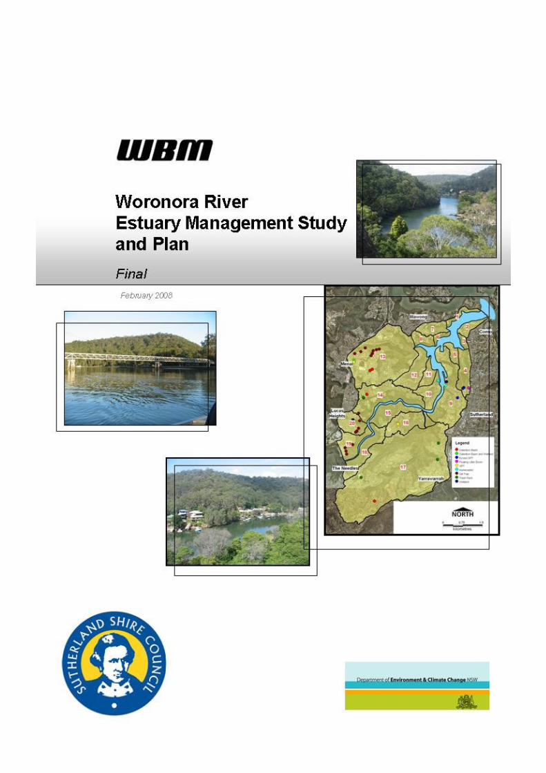
1.2 Study Setting
The Woronora Estuary drains a steep and mostly forested catchment and forms the largest tributary
to the Georges River, 10km upstream from its entrance to Botany Bay.
The catchment is characterised by steep slopes on the eastern and western sides of the Woronora
Valley. The lower catchment has narrow river flats, which are occupied by residential and urban
development. The tidal limit of the estuary is a few hundred metres upstream of an area known as
“The Needles”, on the downstream side of the causeway and rocky falls near the Pass of Sabugal.
The causeway is around 10 km upstream of the confluence with the Georges River. Upstream of the
tidal limit, the river becomes narrow and incised within a steep bedrock valley. Figure 1-1 shows the
main features of the Woronora Estuary and its catchment.

PREAMBLE 2
K:\N0972_WORONORA_RIVER_EPS&EMS&EMP\DOCS\FINALEMS&EMP\R.N0972.002.01.EMS&EMP_FINAL.DOC 22/2/08 17:02
Figure 1-1 Features of the Woronora Estuary and its Catchment
The Woronora Dam is an important feature of the overall catchment, which is located about 20km
upstream of the tidal limit. The construction of Woronora Dam was completed in 1942 (with two
stages of construction between 1927-1931 and 1935-1941). The Dam’s capacity is 71,790 ML, with
a maximum depth of 60m. The catchment area of the Dam is 78.2 km2 which is 45% of the overall
catchment of the Woronora River (ACER, 1995). The Dam is operated by The Sydney Catchment
Authority, which supplies water to the Sydney Water Corporation for the provision of potable water to
some parts of the Sydney metropolitan area.
The Woronora Estuary contains a variety of habitats including intertidal shoals, seagrass, saltmarsh
and mangroves, which are utilised by a range of species of conservation and fisheries significance.
While most of the catchment and foreshore vegetation has been retained, reclamation activities, bank
PREAMBLE 3
K:\N0972_WORONORA_RIVER_EPS&EMS&EMP\DOCS\FINALEMS&EMP\R.N0972.002.01.EMS&EMP_FINAL.DOC 22/2/08 17:02
erosion and foreshore protection works have caused some degree of physical disturbance. The
wider catchment supports a mix of vegetation communities dominated by Gully Forest and
Sandstone Ridge top Woodland.
For the purposes of the estuary management process, the Woronora Estuary includes the waterway
(between the Georges River and the tidal limit), foreshores, and adjacent lands (riparian zone) of the
Woronora River. The riparian zone has been broadly classified as the area 100 m either side of the
waterway, although in some cases, it may be appropriate to vary this depending on the local
conditions and issues of concern. The entire catchment is also considered as part of this Estuary
Management Study insofar as it influences the condition of the estuary.
1.3 The NSW Government Estuary Management Framework
In 1992, the NSW State Government introduced an Estuary Management Policy, aimed at managing
the growing pressures on estuarine ecosystems. The policy is implemented through an Estuary
Management Program, which is co-ordinated by the Department of Environment and Climate Change
(DECC) in co-operation with local government and the community.
The process of managing an estuary, in accordance with this Policy, is initiated by the establishment
of an Estuary Management Committee. This Committee is responsible for the development of an
Estuary Processes Study, followed by an Estuary Management Study and Estuary Management Plan
(refer Figure 1-3). Once the Plan has been accepted by Council, the Community and the relevant
Government departments, the Plan can be implemented through planning controls, works programs,
monitoring programs, and education services.
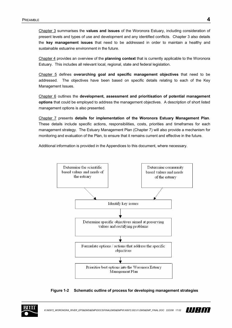
1.4 Structure of this Report
This document provides the basis for selection of strategic management actions that will be
incorporated into the Woronora Estuary Management Plan. As such, the document contains an array
of information regarding the physical and biological processes, the community values, and the
planning framework of the Woronora Estuary. This document comprises both the Estuary
Management Study (Chapters 2 through 6) and the Estuary Management Plan (Chapter 7).
In arriving at the strategic management actions, a process was followed to determine which actions,
should be included in the Estuary Management Plan. The various steps of this process are
documented in this Estuary Management Study report as described in Figure 1-2.
Presented below is a basic outline of the contents of each chapter of this report, as they relate to the
overall process of establishing long-term management strategies for the Woronora Estuary.
Chapter 2 presents a summary of background information including the Estuary Processes
Study and the results of community consultation carried out for this project. The Estuary
Processes Study outlines all of the fundamental physical, chemical and biological processes that
currently occur within the Woronora Estuary, and how these processes need to be considered and
managed in the future. The results of the community consultation details issues the community
consider are most important to the Woronora Estuary, the ways in which they currently use the
Woronora Estuary, and some suggested options for sustainable future management.
PREAMBLE 4
K:\N0972_WORONORA_RIVER_EPS&EMS&EMP\DOCS\FINALEMS&EMP\R.N0972.002.01.EMS&EMP_FINAL.DOC 22/2/08 17:02
Chapter 3 summarises the values and issues of the Woronora Estuary, including consideration of
present levels and types of use and development and any identified conflicts. Chapter 3 also details
the key management issues that need to be addressed in order to maintain a healthy and
sustainable estuarine environment in the future.
Chapter 4 provides an overview of the planning context that is currently applicable to the Woronora
Estuary. This includes all relevant local, regional, state and federal legislation.
Chapter 5 defines overarching goal and specific management objectives that need to be
addressed. The objectives have been based on specific details relating to each of the Key
Management Issues.
Chapter 6 outlines the development, assessment and prioritisation of potential management
options that could be employed to address the management objectives. A description of short listed
management options is also presented.
Chapter 7 presents details for implementation of the Woronora Estuary Management Plan.
These details include specific actions, responsibilities, costs, priorities and timeframes for each
management strategy. The Estuary Management Plan (Chapter 7) will also provide a mechanism for
monitoring and evaluation of the Plan, to ensure that it remains current and effective in the future.
Additional information is provided in the Appendices to this document, where necessary.
Figure 1-2 Schematic outline of process for developing management strategies

PREAMBLE 5
K:\N0972_WORONORA_RIVER_EPS&EMS&EMP\DOCS\FINALEMS&EMP\R.N0972.002.01.EMS&EMP_FINAL.DOC 22/2/08 17:02
ESTUARY MANAGEMENT COMMITTEE
ASSEMBLY OF EXISTING DATADiscover and assemble relevant data
ESTUARY PROCESS STUDYHydraulics: tidal, freshwater, flushing, salinity, water quality & sediment behaviour, etc
Biology: habitats, species, populations, endangered species, etcImpacts: impact of human activities on hydraulics and biology
ESTUARY MANAGEMENT STUDYEssential Features: physical, chemical, ecological, economic, social & aesthetic
Current Uses: activities, land tenure & control, conflicts of useConservation Goals: preservation, key habitats
Remedial Goals: restoration of economic qualityDevelopment: acceptable commercial & public works & activities
Management Objectives: identification & assessmentManagement Options: implementation of options
Impacts: impact of proposed management measures
ESTUARY MANAGEMENT PLANManagement objectives
Description of how the estuary will be managedRecommendations
Schedule of activities to implement recommendations
PLAN REVIEWPublic & Government
IMPLEMENTATIONLocal Government Planning ControlsState Government Planning Controls
Remedial WorksMonitoring ProgramsEducation ProgramsCommunity Services
Monitoring
Figure 1-3 NSW Government’s Estuary Management Process
Completed by WBM in 2006
This Report
This Report
Completed by WBM in 2004
PREAMBLE 6
K:\N0972_WORONORA_RIVER_EPS&EMS&EMP\DOCS\FINALEMS&EMP\R.N0972.002.01.EMS&EMP_FINAL.DOC 22/2/08 17:02
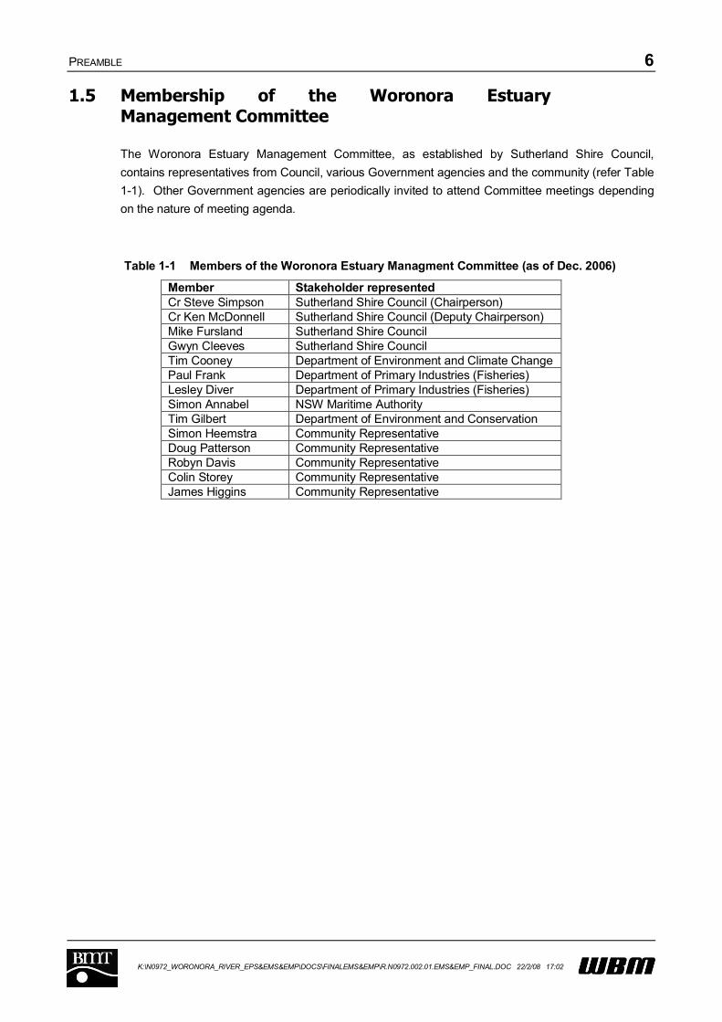
1.5 Membership of the Woronora Estuary Management Committee
The Woronora Estuary Management Committee, as established by Sutherland Shire Council,
contains representatives from Council, various Government agencies and the community (refer Table
1-1). Other Government agencies are periodically invited to attend Committee meetings depending
on the nature of meeting agenda.
Table 1-1 Members of the Woronora Estuary Managment Committee (as of Dec. 2006)
Member Stakeholder representedCr Steve Simpson Sutherland Shire Council (Chairperson)Cr Ken McDonnell Sutherland Shire Council (Deputy Chairperson)Mike Fursland Sutherland Shire CouncilGwyn Cleeves Sutherland Shire CouncilTim Cooney Department of Environment and Climate ChangePaul Frank Department of Primary Industries (Fisheries)Lesley Diver Department of Primary Industries (Fisheries)Simon Annabel NSW Maritime AuthorityTim Gilbert Department of Environment and ConservationSimon Heemstra Community RepresentativeDoug Patterson Community RepresentativeRobyn Davis Community RepresentativeColin Storey Community RepresentativeJames Higgins Community Representative
PREVIOUS INVESTIGATIONS 7
K:\N0972_WORONORA_RIVER_EPS&EMS&EMP\DOCS\FINALEMS&EMP\R.N0972.002.01.EMS&EMP_FINAL.DOC 22/2/08 17:02
2 PREVIOUS INVESTIGATIONS
The Woronora Estuary Management Plan aims to mitigate existing and future threats to the key
values of the Woronora Estuary. Two parallel and related approaches have been undertaken to
identify these values and their corresponding threats. First, a scientific approach to understanding
the physical, chemical and biological status of the estuary has been undertaken. This has focussed
on the existing available information, along with additional scientific investigations (refer Section 2.1).
Secondly, a program of community and stakeholder consultation (including government agencies)
has been undertaken to identify the existing human uses and demands on the Woronora Estuary
(refer to Section 2.2). A synthesis of overall estuary values and threats is provided in Chapter 3.
2.1 Previous scientific investigations
The Woronora Estuary Data Compilation Study (WBM, 2004), compiled, documents and reviewed
the existing data, reports and information relevant to the Woronora Estuary. Where relevant,
information outside the immediate study area that relates to the Estuary was also considered.
Subsequent to the Data Compilation Study, an Estuary Processes Study was undertaken (WBM,
2006). An overview of the Estuary Processes Study is presented below.
2.1.1 The catchment
Approximately 81% of the Woronora River catchment, including areas upstream of the estuary,
remains largely undeveloped and forested. This high proportion of undeveloped bushland may be
partially attributed to the steep topography of the incised river valley. The eastern and western sides
of the upper Woronora Valley are particularly steep, while the lower catchment (middle to lower
estuary) contains narrow river flats that are occupied by residential and urban development. The tidal
limit of the estuary is just upstream of ‘The Needles’, approximately 10 km upstream of the
Woronora’s confluence with the Georges River.
The Woronora Dam is located approximately 20 km upstream of the tidal limit. The Dam impedes
small and medium flood events from reaching the estuary. A reduction in freshwater inflow to the
estuary caused by the Dam has resulted in the upper section of the estuary becoming typically more
saline.
2.1.2 Tides
The tidal range at the most upstream extent of the Woronora Estuary (Pass of Sabugal) is
approximately the same as the tidal range at the downstream end of the Woronora Estuary. An
average of 1,600ML of water flows in and out of the Woronora with each tide (occurring twice daily).
This volume is significantly greater than the estimated average freshwater flows of approximately
30ML/day. Consequently, the Woronora Estuary is primarily influenced by marine waters, except
during times of significant flood. Marine dominance decreases with distance upstream as tidal
flushing times increase, and freshwater inflows are more comparable to tidal exchange volumes. The
average lag at high tide between the ocean and Woronora Bridge, located in the middle reaches of
the estuary, is approximately one hour.
PREVIOUS INVESTIGATIONS 8
K:\N0972_WORONORA_RIVER_EPS&EMS&EMP\DOCS\FINALEMS&EMP\R.N0972.002.01.EMS&EMP_FINAL.DOC 22/2/08 17:02
2.1.3 Freshwater flows
An average freshwater flow of about 34,000 m3/day (or 34ML/day) enters the estuary over a concrete
weir at the Pass of Sabugal, Engadine, just upstream of the tidal limit. Highest rainfall in the
Woronora catchment typically occurs in February and March, while the driest months occur during
late winter and early spring.
Major flood events tend to result in significant elevation of the water levels in the upper reaches of the
estuary, with significant water surface gradients between the tidal limit and Forbes Creek (middle
reaches) during large events. Downstream of Forbes Creek, the flood waters are able to flow out of
the incised river valley and onto adjacent floodplains which contain some residential development
(e.g. the suburb of Woronora). River flooding is an issue, particularly where floodplains have been
filled to accommodate residential development (such as in the river reaches immediately upstream of
the Woronora Bridge and at Bonnet Bay).
After flood events, deeper holes on the outside of river bends in the upper reaches of the estuary may
become stratified, with the warmer, fresh catchment waters overlying the colder and more saline
marine waters. At other times, the estuary is generally well mixed.
2.1.4 Waves
The narrow, incised and sinuous nature of the Woronora Estuary does not allow significant wind-
generated waves to form. Only during an extreme wind condition in the downstream parts of the
Estuary would a wave of over 0.5 m in height be expected. Waves of significant size can, however,
be generated by boat wash, and are considered to have contributed to current foreshore erosion in
some reaches (particularly within the existing 8 knot speed limit zone).
2.1.5 Water quality considerations
The key inputs of nutrients, organics, bacteria and other pollutants to the Woronora Estuary are
primarily derived from local catchment runoff following rainfall. Overflows from Sydney Water’s
sewerage network, particularly during wet weather, may also discharge pollutants to the estuary from
time to time.
The quality of the water within the estuary is the resultant of the magnitude of inputs and the in-
stream assimilation by biological and chemical processes. Recent monitoring data for the estuary is
sparse, and the development of a targeted and holistic water quality and ecological health monitoring
program is recommended by this Estuary Management Study.
Water quality data available for the Woronora estuary and catchment (including Council’s SWAMP
Storm Water Monitoring Program) is biased towards areas of poor water quality, as these locations
are targeted for monitoring (e.g. major stormwater outlets). The most recent water quality data is
more than 4 years old and may no longer reflect present day conditions. An assessment of the data
collected over a 10 year period suggest that water quality is improving, with the majority of sites
showing decreasing concentrations of selected parameters (including nutrients, bacterial indicators,
BOD and heavy metals). Varying meteorological conditions over this same period (e.g. reducing
rainfall) may have convoluted the results, however.

PREVIOUS INVESTIGATIONS 9
K:\N0972_WORONORA_RIVER_EPS&EMS&EMP\DOCS\FINALEMS&EMP\R.N0972.002.01.EMS&EMP_FINAL.DOC 22/2/08 17:02
At times, locations within the estuary are not suitable for human contact (particularly in the vicinity of
stormwater outlets). Bacterial indicators of risk to human health (enterococci and faecal coliforms)
frequently exceeded recreational guidelines in tributaries to the Woronora Estuary.
Nutrient concentrations were also typically elevated, however, but somewhat typical of urban
stormwater where the data has been primarily collected.
2.1.6 Sediment properties
The Woronora catchment is characterised by highly erodible sandy soils. Sediment from the
catchment is carried into the river during large rainfall events and is redistributed by floods and tides,
depositing and reforming shoals.
Overall, the sediments of the Woronora Estuary are relatively clean. This may be attributed to the
lack of industrial activity in the catchment and the low fines content of the quartzose sand bed
material, which has a low capacity to adsorb contaminants. Acid sulphate soils (ASS) are not a
significant issue for the Woronora Estuary due to the mostly incised nature of the system (WBM,
2007).
2.1.7 Dredging
In response to concerns about navigation, approximately 400,000 m3 of sediment was dredged in the
late 1960’s and early 1970’s from the middle reaches of the Estuary between Forbes Creek and
Bonnet Bay. This area has been subject to deposition over the last 35 years and continues to infill at
a reducing rate. Dredged sediment was used for filling low lying areas adjacent to the River.
2.1.8 Sediment transport
The Woronora Estuary between the tidal limit and the Georges River confluence is considered to be a
‘mature’ estuary, meaning that the gross infilling process is basically complete and the amount of
sediment that enters the Estuary from the catchment will roughly balance the amount leaving it, when
averaged over the long term. Within this dynamic equilibrium, sand continues to move in a
dominantly downstream direction, under the influence of intermittently occurring floods.
Issues with navigation associated with variable shoals and sedimentation may be attributed to the
natural movement of sediment in response to the dominant hydrological and tidal processes, and
increased loads of sediment being delivered to the estuary due to land clearing and catchment
development. The Forbes Creek catchment is considered to have contributed a significant sediment
load to the estuary over the past 30 years, as a result of urban development during this time.
Given the present rate of sand export from the catchment, periodic dredging may be necessary to
maintain navigation within the Estuary. Reducing the sediment load could also be achieved through
the installation and maintenance of appropriate stormwater quality improvement devices in the
catchment.

PREVIOUS INVESTIGATIONS 10
K:\N0972_WORONORA_RIVER_EPS&EMS&EMP\DOCS\FINALEMS&EMP\R.N0972.002.01.EMS&EMP_FINAL.DOC 22/2/08 17:02
2.1.9 Bank condition
Overall, boat wash is considered to be the dominant cause of bank erosion in the Woronora River.
This is exacerbated in the downstream reaches of the estuary, where larger and more frequent boat
traffic is present, including the vicinity of Janalli Reserve (where previous attempts at foreshore
protection have been outflanked by erosion), between Janalli Reserve and the Bonnet Bay Boat
Ramp (where mangroves are being substantially undermined) and Lakewood City Reserve at Bonnet
Bay.
Boat wash is contributing to erosion as far upstream as Deepwater Estate. Beyond this, however, the
main cause of bank erosion is likely to be attributed to rare flood events eroding foreshores that
comprise loose sandy material.
Foreshore structures associated with residential development are present throughout the estuary.
Overall, the foreshore structures tend to be in a reasonable condition, although there are examples of
quite severe dilapidation (e.g. at Illawong, and in the upper reaches near Shackels Estate). In some
instances, structures are poorly sited, such as in areas of Bonnet Bay, where inadequate depth is
present and floating pontoons sit on the bed at low tide.
2.1.10 Ecology
The Woronora Estuary contains a range of high quality habitats and species of conservation and
fisheries significance. While most of the catchment and foreshore vegetation has been retained,
reclamation activities, bank erosion and foreshore protection works have caused some degree of
physical disturbance.
There have been major changes in saltmarsh and mangrove distribution over the past 70 years
(WBM, 2007). One aspect of this is the landward expansion of mangroves into saltmarsh areas.
Seaward expansion of mangroves into new habitat due to localised sedimentation is also believed to
be an issue in some areas (e.g. Mangrove Island).
Seagrass species belonging to the family Zosteracea (eelgrass) was recorded during field
inspections. It is possible that a second genus Halophila, occurs in the estuary from time to time.
Halophila Ovalis is a highly ephemeral species, and is commonly found in association with
Zosteraceae in eastern Australia estuaries. In general, seagrass beds were recorded on several
shoals within the main channel of the fluvial delta and riverine channel zones and within Forbes
Creek. Beds are generally small and highly fragmented, albeit with dense cover (50-90%).
Comparisons of marine vegetation maps produced at various times showed that there are major
differences in seagrass bed distribution and extent, although it is difficult to determine whether this
reflects actual temporal changes or differences in mapping methodology.
While commercial fishing (other than the taking of lobsters and abalone in accordance with share
management plans) is banned within the Woronora Estuary, recreational fishing is very popular.
Commonly caught species include yellowfin bream, Australian Bass, mullet, dusky flathead and
luderick. The barrier to fish passage imposed by the weir at the Pass of Sabugal (upstream of tidal
limit) is likely to be an issue for fish that migrate between fresh and marine waters such as the
nationally protected Australian Grayling and Australian Bass. At the time of writing, a fishway is
planned for construction at the pass of Sabugal.

PREVIOUS INVESTIGATIONS 11
K:\N0972_WORONORA_RIVER_EPS&EMS&EMP\DOCS\FINALEMS&EMP\R.N0972.002.01.EMS&EMP_FINAL.DOC 22/2/08 17:02
The relatively close proximity of the Ramsar listed Towra Point wetlands and the existence of
intertidal habitats suggest that the Woronora Estuary may be an important site for migratory and
resident wader birds.
Benthic macroinvertebrate sampling undertaken for the Estuary Processes Study suggests possible
nutrient enrichment of sediments within Forbes Creek, given high densities of Capitellidae worms.
Future monitoring of the Woronora Estuary should include biological indicators, such as
macroinvertebrate assemblages, estuarine vegetation condition and distribution, and local fish stocks,
to provide a more holistic assessment of overall estuary health.
2.1.11 Human Uses
Passive recreational activities such as canoeing, swimming and picnicking are most common in the
Woronora Estuary. Some residents in suburbs such as Deepwater and Shackles Estate do not have
road access and utilise the estuary on a daily basis to commute to parked vehicles. Commercial
activities are very low key and include the Woronora Caravan Park, boat hire facilities and a number
of small eateries.
More detail on Human Use is presented in Section 3.4
2.1.12 Heritage
The Aboriginal Heritage value of the Woronora River Estuary and its catchment is significant. This is
reflected in the number of sites listed in the Aboriginal Heritage Inventory Management System
(AHIMS) Register and the inclusion of one site on the Register of the National Estate. While the
location of these sites is considered too sensitive for public release, their protection remains an
important consideration for future management.
The Woronora Estuary also has heritage value from a European perspective. More detail on
Heritage Issues is presented in Section 3.4.
2.2 Community and Stakeholder Consultation
The development of the Woronora Estuary Management Plan has involved significant community and
stakeholder consultation in order to obtain data, listen to concerns and evaluate ideas.
This consultation has included the development of a customised, project-specific website which was
established and launched in June 2005. The website provides background information on the study
and access to relevant information. The site functionality also allows visitors to register for the project
consultation database and to contact the study team.
The web address for the project website is www.woronora-ems.com.au
A variety of future Management Options were canvassed by the community and stakeholders during
all phases of the community consultation and those have been integrated into our analysis of
potential management options as outlined in Section 6.
PREVIOUS INVESTIGATIONS 12
K:\N0972_WORONORA_RIVER_EPS&EMS&EMP\DOCS\FINALEMS&EMP\R.N0972.002.01.EMS&EMP_FINAL.DOC 22/2/08 17:02
2.2.1 Newsletter 1 and Questionnaire
The first community newsletter (refer Appendix B1), which was distributed during the Estuary
Processes Study, provided a brief outline of the project and a questionnaire form. The questionnaire
was targeted at obtaining any relevant information from the community including photos, flood marks
and historical data along with information about their current usage of the waterway, what they
like/dislike about the waterway, and suggested options for the future management of the estuary.
The distribution list for this document included around 1037 ratepayers and residents and ten
community and stakeholder groups. The community groups contacted were:
Woronora Precinct Residents Association;
Woronora River Residents Environmental Action Committee;
Woronora Life Saving and River Patrol Club;
Sydney Catchment Authority;
Woronora River Public School;
Gandagara Local Aboriginal Land Council;
National Parks & Wildlife Service;
DIPNR;
DPI Fisheries ; and
NSW Maritime.
179 responses were received. This represents a 17% response rate, which is comparable to the
response rate of similar studies.
The results of this consultation have been considered during the development of the Estuary
Management Plan.
2.2.1.1 Results of Questionnaire
Activities
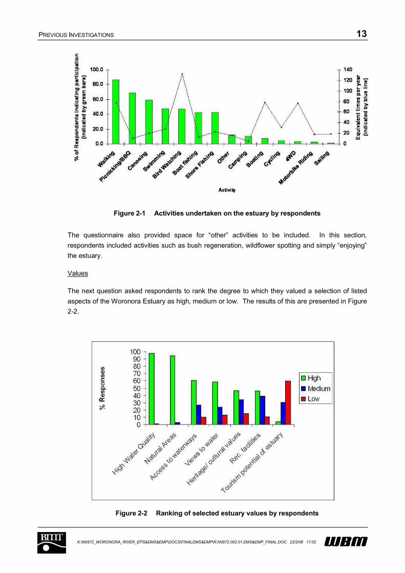
The first question asked respondents to indicate which of the listed activities they undertake within the
estuary and surrounding lands. It also asked respondents to indicate how frequently they undertake
these activities. Their results are presented in Figure 2-1.
PREVIOUS INVESTIGATIONS 13
K:\N0972_WORONORA_RIVER_EPS&EMS&EMP\DOCS\FINALEMS&EMP\R.N0972.002.01.EMS&EMP_FINAL.DOC 22/2/08 17:02
Figure 2-1 Activities undertaken on the estuary by respondents
The questionnaire also provided space for “other” activities to be included. In this section,
respondents included activities such as bush regeneration, wildflower spotting and simply “enjoying”
the estuary.
Values
The next question asked respondents to rank the degree to which they valued a selection of listed
aspects of the Woronora Estuary as high, medium or low. The results of this are presented in Figure
2-2.
Figure 2-2 Ranking of selected estuary values by respondents
PREVIOUS INVESTIGATIONS 14
K:\N0972_WORONORA_RIVER_EPS&EMS&EMP\DOCS\FINALEMS&EMP\R.N0972.002.01.EMS&EMP_FINAL.DOC 22/2/08 17:02
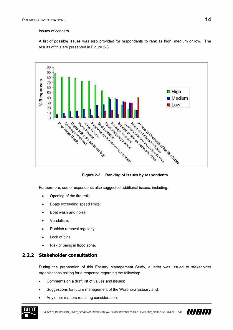
Issues of concern
A list of possible issues was also provided for respondents to rank as high, medium or low. The
results of this are presented in Figure 2-3.
Figure 2-3 Ranking of issues by respondents
Furthermore, some respondents also suggested additional issues, including:
Opening of the fire trail;
Boats exceeding speed limits;
Boat wash and noise;
Vandalism;
Rubbish removal regularly;
Lack of bins;
Risk of being in flood zone.
2.2.2 Stakeholder consultation
During the preparation of this Estuary Management Study, a letter was issued to stakeholder
organisations asking for a response regarding the following:
Comments on a draft list of values and issues;
Suggestions for future management of the Woronora Estuary and;
Any other matters requiring consideration.
PREVIOUS INVESTIGATIONS 15
K:\N0972_WORONORA_RIVER_EPS&EMS&EMP\DOCS\FINALEMS&EMP\R.N0972.002.01.EMS&EMP_FINAL.DOC 22/2/08 17:02
The organisations contacted were:
Internal Sutherland Shire Council (SSC) departments;
NSW Maritime;
Department of Environment and Climate Change;
NSW Fisheries; and
Department of Lands.
This letter is reproduced in Appendix B3.
2.2.3 Newsletter 2
A second newsletter was sent to community members who had previously indicated an interest in
additional consultation. In total, the second newsletter was sent to 136 individuals and organisations.
The newsletter was issued during the preparation of the Estuary Management Study, and provided a
summary of the findings from the Estuary Processes Study. The newsletter also requested initial
feedback on a set of draft management objectives for the Woronora Estuary. The second newsletter
is reproduced in Appendix B4.

VALUES AND ISSUES FOR FUTURE MANAGEMENT 16
K:\N0972_WORONORA_RIVER_EPS&EMS&EMP\DOCS\FINALEMS&EMP\R.N0972.002.01.EMS&EMP_FINAL.DOC 22/2/08 17:02
3 VALUES AND ISSUES FOR FUTURE MANAGEMENT
3.1 Introduction
The Estuary Management Plan is a strategic document aimed at securing long-term sustainability of
the estuary with respect to ecological, social and economic values. To develop an effective
management plan it is necessary to determine the important ‘values’ and ‘issues’ associated with the
Estuary.
Values represent those features of the estuary that warrant conservation and/or recognition. The
values have been determined from an appreciation of the scientific processes of the estuary, as well
as community and stakeholder consultation described in Section 2.2
Issues represent problems with the estuary that need to be resolved in the future. These issues
have also been determined through the scientific assessment and the information provided through
community and stakeholder consultation.
The values and issues associated with the Woronora Estuary are documented in this Chapter. Many
issues have evolved through poor estuary and land management practices in the past, while others
relate to the potential impact of catchment practices in the future.
3.2 National, state and regional significance of the Estuary
Regional Significance
The Woronora Estuary is home to at least 87 species of fish, crustacean and mollusc, with 37 species
(42% of species) and 64% of total catch comprised of species of direct commercial or recreational
fisheries value (Williams and Louden, 2004),
State Significance
The Woronora Estuary catchment contains the following vegetation communities that are listed as
Endangered Ecological Communities under the NSW Threatened Species Conservation Act 1995:
Turpentine-Ironbark Margin Forest;
Paperbark Communities;
Coastal Saltmarsh.
National Significance
The Register of the National Estate is a listing of places of natural, historic and indigenous
significance compiled by the Australian Heritage Commission since 1976. Within the estuary and
immediate surrounds, the following items are included:
an indigenous place in Woronora, (specific details withheld); and
Como Rail Bridge.
VALUES AND ISSUES FOR FUTURE MANAGEMENT 17
K:\N0972_WORONORA_RIVER_EPS&EMS&EMP\DOCS\FINALEMS&EMP\R.N0972.002.01.EMS&EMP_FINAL.DOC 22/2/08 17:02
There are also further items of interest to this study that have the status of an “indicative place” on the
register. This means that they have been nominated but not yet assessed and registered, or
dismissed. These items include the Como Tidal Pool, Como Pleasure Grounds and Prince Edward
Park.
The Environment Protection and Biodiversity Conservation Act 1999 (EPBC) protected matters
database lists threatened species and communities of national conservation significance. One fish
species of conservation significance, namely, the Australian Grayling (Prototroctes maraena)
potentially occurs in the wider Woronora estuary. The Woronora River estuary itself is recognised in
the EPBC protected database as an area likely to contain habitat for two species of migratory wader
birds, namely: Japanese Snipe (Gallinago hardwickii) and the Painted Snipe (Rostratula
benghalensis s. lat.).
3.3 Values of the Estuary
3.3.1 Introduction
The aspects of the Woronora Estuary most valued by the local community, in priority order, are:
High water quality;
Natural areas;
Access to waterways;
Views to water;
Heritage and cultural value; and
Recreational facilities.
(Source: community consultation, refer to Section 2.2).
3.3.2 Threats to estuary values
Compared with other similar estuaries within NSW, and particularly the Greater Metropolitan Region,
very few threats to estuary values were identified for the Woronora Estuary. This may be attributed
to:
The large portion of the greater catchment that is “locked up” as either National Park or the
catchment area of Woronora Dam;
The steep topography which limits future development potential; and
The low key nature of existing foreshore development.
As such, the focus of the Estuary Management Plan will be on proactive strategies to protect existing
values.

VALUES AND ISSUES FOR FUTURE MANAGEMENT 18
K:\N0972_WORONORA_RIVER_EPS&EMS&EMP\DOCS\FINALEMS&EMP\R.N0972.002.01.EMS&EMP_FINAL.DOC 22/2/08 17:02
3.4 Present uses and conflicts
3.4.1 Land use
Catchment land use determines the general quality of the water that runs off the catchment and into
the Estuary. Catchment runoff from forested areas tends to have the best water quality, whereas
urban runoff is typically characterised by elevated nutrients, sediments and some heavy metals.
During times of intense bushfire, the loss of vegetative ground cover from forested areas exposes the
soil to increased runoff, resulting in higher sediment and nutrient loads. Urban areas are also
characterised by faster, more concentrated flows from the catchment, which have a greater erosive
potential.
3.4.1.1 Historical and present land use
Historical use of the Estuary is discussed in detail in the Estuary Processes Study. Use of the
Woronora Estuary by Aboriginal people would have been extensive, as illustrated by the richness of
indigenous heritage sites found in the area.
Historical European land use was also analysed using GIS as part of the Estuary Processes Study.
On the basis of aerial photography (1930, 1984) and the present zoning of the catchment, it was
found that the proportion of impervious land directly draining to the estuary had varied from 6% in
1930, to 13% in 1984 to 28% at present.
The present zoning of the Woronora Catchment, under Sutherland Shire Council’s Local
Environmental Plan, is discussed in Section 4.3.2. Some areas in the upper extents of the
catchment are located within the Wollongong City Council and Campbelltown City Council Local
Government Areas.
A large amount of the entire Woronora catchment (~80% - including areas upstream of Woronora
Dam) remains in a natural condition (i.e. remnant bushland), while other areas have been developed
primarily for residential and associated commercial land uses, with a very small proportion of the
catchment currently being used for industrial purposes.
3.4.1.2 Road access
There are two estuary foreshore subdivisions without formal road access. These are Deepwater and
Shackels Estates.
Deepwater Estate is an area of houses built very close to the estuary, just upstream of the township
of Woronora. The only access to Deepwater Estate is via boat or pedestrian access along a
waterfront path. Opposite Deepwater Estate, and extending further upstream, is Shackels Estate.
The houses in Shackels Estate tend to be built higher above the waterway than those at Deepwater
Estate and have pedestrian and/or vehicular access from unofficial ridgeline roads.
A Fire Trail, closed to public vehicular access, links the suburb of Woronora to Woronora Heights,
which is perched on the plateau above the River to the south of Woronora, and north of the suburb of
Engadine and is theoretically used for emergency access only. The fire trail cuts through the
VALUES AND ISSUES FOR FUTURE MANAGEMENT 19
K:\N0972_WORONORA_RIVER_EPS&EMS&EMP\DOCS\FINALEMS&EMP\R.N0972.002.01.EMS&EMP_FINAL.DOC 22/2/08 17:02
ecological corridor linking Heathcote National Park and Loftus, via Woronora to Bonnet Bay, Como,
Sutherland and Jannali. A very contentious issue among the local community has been the proposed
conversion of the fire trail to a bus link between Bundanoon Road, Woronora Heights, and The
Crescent, Woronora. Many residents of Woronora are concerned about the potential for significant
future traffic increases through their generally quiet suburb, whereas some residents of Woronora
Heights and North Engadine desire the considerable reduction in travel times when heading north
that would be gained from construction of the link road. At present, Woronora Heights residents need
to travel some distance south before gaining access to the Princes Highway in order to travel
northwards to Sutherland and beyond. In 2006, the NSW State Government intervened and rezoned
the fire trail, precluding its use for either public or general transport.
While emergency access was considered to be a significant issue for future management among
respondents to the community questionnaire, access to Deepwater and Shackels Estate was ranked
as the least significant issue of those listed.
3.4.1.3 Shackels Estate Acquisition Program
Shackels Estate was first developed in 1916, on the northern foreshore of the Woronora River
between Woronora and The Needles. The area is not serviced by Council roads. The Shackels
Estate Acquisition Program was introduced in 1973, with the aim of returning the site to natural
bushland.
The acquisition program was reportedly quite rapid in its early stages, with state government
providing funds to purchase properties at full market price and Council taking responsibility for
decommissioning of existing infrastructure. In more recent times there has been significant
opposition to the acquisition program and it was short listed as an important issue in the Woronora
Estuary Data Compilation (WBM 2004). By 1997, 291 properties had been acquired through the
program and only 23 remained. Consultation with Sutherland Shire Council Planning Department
confirms that this remains the case and that three of the remaining properties are heritage listed and
therefore will not be removed (Mike Fursland SSC, pers. com. 2006).
The Shackels estate foreshore subject to the acquisition program is shown in Figure 3-1.
The physical removal of buildings and vegetation from properties purchased as part of the program
has not been without problems. In many locations, remnants of demolished building materials can be
readily found close to the foreshore. The potential that harmful materials such as asbestos still
remain on site needs to be considered. Furthermore, the existence of hardy exotic vegetation and
land that has been disturbed has resulted in the proliferation of exotic weeds along some areas of
foreshore.
Based on the results of the community consultation, management of Shackels Estate does not
appear to be a significant concern for future management of the Woronora Estuary to the broader
community. Nevertheless, the broader issues of weed invasion and riparian vegetation management
are of importance to the community. These are issues that need to be addressed at Shackels Estate.

VALUES AND ISSUES FOR FUTURE MANAGEMENT 20
K:\N0972_WORONORA_RIVER_EPS&EMS&EMP\DOCS\FINALEMS&EMP\R.N0972.002.01.EMS&EMP_FINAL.DOC 22/2/08 17:02
Figure 3-1 Location of Shackels Estate
3.4.1.4 Waterway and Foreshore Usage
Recreational Uses
As discussed in Section 2.2.1.1 passive recreational uses are relatively common in the Woronora
Estuary. The most popular recreation activities were identified as picnicking, canoeing, bushwalking
along the estuary, bird watching and swimming.
A potential issue for recreational use of the Woronora Estuary may be poor water quality. The
Estuary Processes Study has found that bacterial quality of the water in some locations may not be
suitable for primary or secondary recreational contact, during certain periods.
VALUES AND ISSUES FOR FUTURE MANAGEMENT 21
K:\N0972_WORONORA_RIVER_EPS&EMS&EMP\DOCS\FINALEMS&EMP\R.N0972.002.01.EMS&EMP_FINAL.DOC 22/2/08 17:02
Boating is a popular activity on the Woronora Estuary from a recreational and commuting
perspective. Public boat launching facilities are located at Bonnet Bay, the Woronora Bridge
(Burnum Burnum Sanctuary) and Prince Edward Park. In addition, many private boat launching
facilities front properties along the estuary. This includes a boat launching facility fronting the Rural
Fire Service (RFS) station, on the western foreshore, between the two bridges. Adequacy of existing
infrastructure was not identified as a significant community issue; however, numerous respondents to
the questionnaire were concerned about the erosion impacts of boating.
Redevelopment of Prince Edward Park Wharf
Prince Edward Park Wharf is primarily used by residents of Deepwater Estate. Works are presently
being undertaken to improve safety standards for use by small commuter craft.
Recreational Fishing
Recreational fishing is a popular activity on the Woronora Estuary, as highlighted by respondents of
the community questionnaire (refer to Figure 2-1). Specific data on recreational fishing has not been
identified.
The Great Kai’mia Way Project
The aim of the Great Kai'mia Way project is to create a network of walking trails linking river
foreshores, parks, bushland reserves, public transport and other facilities in the Georges River region.
Opportunities to link management options with this project have been investigated during the
development of the Estuary Management Study.
Commercial Interests
Most of the Woronora Estuary has maintained an undeveloped atmosphere, with the few commercial
interests. These interests are unlikely to be having a significant impact on the estuary.
Commercial fishing
The Woronora River upstream of the Old Woronora Rd Bridge is closed to all nets. Species of
commercial interest are found in the estuary.
Commercial oyster industry
Commercial oyster farming is no longer undertaken in the Woronora Estuary. The oyster industry
has been in decline throughout NSW with the peak production of the 1970s of nearly 150,000 bags
dropping to about 78,000 bags by the mid 1990s (HRC, 2003). This decline may be caused by a
number of influences including decline in water quality, virus scares and the onset of “QX” disease.
QX was first recorded as an issue in the Georges River in 1994 and has lead to the total collapse of
the oyster industry in the Woronora Estuary (and Georges River). QX disease is a parasitic infection
to the Sydney Rock Oyster caused by a protozoan parasite, Marteilia sydneyi. The life cycle of the
organism is not well understood. The latest research indicates that QX is present in a dormant state
in several oyster growing estuaries. However, what triggers it to go from a dormant state to an
outbreak is still unknown. QX is believed to enter the body of the oysters, which are filter feeders, via
the gills and lodge in the lining of the gut. Once there, QX can multiply in the stomach of the oyster,

VALUES AND ISSUES FOR FUTURE MANAGEMENT 22
K:\N0972_WORONORA_RIVER_EPS&EMS&EMP\DOCS\FINALEMS&EMP\R.N0972.002.01.EMS&EMP_FINAL.DOC 22/2/08 17:02
eventually starving it to death (DPI Fisheries, 2004). DPI Fisheries advise that there are some
remaining oyster leases in the Woronora Estuary, which are thought to have some heritage value
(Tim Gippel, DPI, pers. comm., 2006). The community and stakeholder consultation did not indicate
that derelict oyster leases were considered to be an issue for the Estuary.
Tourism
Tourism facilities are limited to the Woronora Caravan Park on Menai Road, the Star Boat Shed
(including a Café and boat hire facilities) on Forbes Creek, and a takeaway shop and restaurant to
the south of the Old Woronora Bridge. There is also an old scout camp opposite Woronora,
upstream of Forbes Creek where camping is allowed for a fee, although this is a very low scale
operation.
Holiday rentals are also common within the vicinity of the Woronora Estuary. Specific information
regarding the numbers of this style of accommodation and the flow on impacts these may have on
seasonal population and associated infrastructure are not available.
Social significance
The Woronora Estuary has significant social value within the local and wider community. The
response to the community consultation indicated that for many people the estuary was a key reason
for living in the area. The Woronora River RSL, Woronora River Primary School and the scout hall
are located very close to the Estuary, with some locals choosing to commute by boat.
There are a number of estuary side reserves that are of significance from a recreational and social
perspective. Details of these reserves are given in Table 3-1.
Table 3-1 Estuary side Reserves and facilities (Source: modified from SSEC, 2003)
Reserve Details
The Glen and Koolangarra Reserves, Bonnet Bay
326m of river frontage 20ha bushland zoned 7(b) Environmental Protection Bushland
under 2000 LEP (Deferred Matter in 2006 LEP) Fire Trails/Sydney Water sewer maintenance track
The Glen Reserve Bushcare Group and Koolangarra Bushcare Group both since 1992
Passive recreation - bushwalking Part of SSC Greenweb/endangered
ecological communityArthur Place Reserve, Bonnet Bay
Council owned 50m of river frontage 1ha bushland zoned Public Open Space (zone 13)
Arthur Place Bushcare Group since 1997 and Nixon Place Bushcare Group since 1993
Passive recreation - bushwalking, swimming, fishing
Part of SSC GreenwebBurnum Burnum Sanctuary (Jannali Reserve)/ Bonnet Bay Reserve, Jannalli
Crown Land managed by SSC 1,500m of river frontage 65ha bushland zoned 7(b) and 6(a) under 2000 LEP,
Environmental Protection Waterway, Public Open Space Bushland, Public Open Space, and Deferred Matter und 2006 LEP.
Boat ramp facilities Car park Baseball field Playground and picnic facilities
Pedestrian link with adjacent Glen Reserve
Streamwatch monitoring in stormwater pond
Jannali Reserve Bushcare Group since 1993, Jannali Reserve (Tyler Place) Bushcare Group since 1999 and Jannali Reserve Boat Ramp Bushcare Group since 2000
Passive recreation - bushwalking, swimming, fishing, playground
Part of SSC Greenweb
Prince Edward Park
Crown land managed by SSC 600m of river frontage
soccer, rugby and cricket fields boat ramp, parking facilities

VALUES AND ISSUES FOR FUTURE MANAGEMENT 23
K:\N0972_WORONORA_RIVER_EPS&EMS&EMP\DOCS\FINALEMS&EMP\R.N0972.002.01.EMS&EMP_FINAL.DOC 22/2/08 17:02
Reserve Details
800m Forbes Creek frontage 45ha bushland and open space zoned Public Open Space (bushland) Known Koala habitat BBQ facilities Walking track system linking Sutherland and
Woronora Prince Edward Park Bushcare Group since 1993 Passive recreation - bushwalking, swimming, fishing Part of SSC Greenweb
public toilets pedestrian bridge over Woronora River Scout Club Royal Lifesaving Club Playground
Lakewood City Reserve, Bonnet Bay
Council owned 735m of river frontage 2.8ha bushland zoned Public Open Space
sports oval tennis courts car park passive recreation - picnicking, fishing,
swimmingForbes Creek Woronora to Engadine
Crown land managed by SSC 1000m Forbes Creek >60ha bushland zoned 7(b) under 2000 LEP, Deferred Matter under
2006 LEP
Forbes Creek Woronora Bushcare Group since 1996, Upper Forbes Creek Bushcare Group since 1996, Forbes Creek South Bushcare Group since 2002, Croston Road Bushcare Group since 2002
Part of SSC GreenwebWoronora River Reserve, Woronora
Crown land managed by SSC 860m of river frontage 22ha bushland
zoned 6(a) Passive recreation - fishing, boating,
bushwalking Part of SSC Greenweb
Prices Circuit, Woronora
Crown land managed by SSC 400m of river frontage 1.5ha public open space zoned as Public Open Space seawall
car park BBQ facilities Playground Picnicking Passive recreation - fishing, swimming
Prices Circuit Reserve, Woronora
Crown land managed by SSC 1,000m of river frontage 25ha bushland Zoned as Public Open Space Bushland part of SSC Greenweb - known Powerful Owl
habitat, Endangered Ecological Community
Fire Trails Woronora Public School Bushcare
Group Passive recreation - boat landing,
fishing, swimming, picnicking
River Road Public Jetty, Woronora
Council owned 12m of river frontage public jetty Boating access to Deepwater Estate properties
Car park Public toilet facilities Passive recreation - fishing, swimming
Shackels Estate Reserve
Council owned 100m of river frontage
passive recreation - boat landing canoeing, fishing, swimming
The Woronora community has an isolated village atmosphere, despite the townships proximity to
metropolitan Sydney. The construction of the high level bridge has effectively removed much of the
traffic from suburban streets, adding to the village feel.
3.4.2 Human impacts and conflicts
Human activities have had some impact on all environmental processes associated with the
Woronora Estuary. Table 3-2 presents a brief summary of key human impacts. Note that this
summary is limited to the current understanding of estuarine processes, which is restricted by
available data and scientific knowledge.

VALUES AND ISSUES FOR FUTURE MANAGEMENT 24
K:\N0972_WORONORA_RIVER_EPS&EMS&EMP\DOCS\FINALEMS&EMP\R.N0972.002.01.EMS&EMP_FINAL.DOC 22/2/08 17:02
Table 3-2 Identified impacts of human activities on estuarine processes
Process Key Human ImpactsCatchment inputs (including runoff and sewerage overflows) contributing to high nutrients, high bacterial contamination and elevation of some heavy metals in the water columnTidal intrusion from the Georges River contributing to high nutrients, high bacterial contamination and elevation of some heavy metals in the water column
Water Quality
Woronora Dam – reduced freshwater flows increasing salinity in upstream reaches of estuaryDam regulation of freshwater flows – small to medium floods no longer reaching the estuaryDredging of entrance sand spit – increased tidal prism Possible contamination of groundwater from industrial leachate –unconfirmed Filling of floodplains to allow residential development- altered flood patterns
Hydrodynamics
Construction of Woronora Bridge-localised increase in flood levels of 0.03 mDam construction – reduced connectivity between fresh and estuarine areasReclamation loss of shallow sandy shoal, and wetland habitat (e.g. Bonnet Bay)Increased tidal prism due to removal of sand shoal and sedimentation due to catchment development contributing to mangrove encroachment upon saltmarsh areas Declining water quality impacting on resident ecologySabugal Pass Weir interrupting fish passage Edge effects of developmentPotential impacts of recreational fishing on fish stocks
Ecology
Foreshore protection works replacing natural habitatsCatchment development – increase in sediment loadsBoat wake causing erosion of the banks
Sediment and Erosion Processes Reclamation and associated vegetation removal weakening
banks and increasing sedimentation
VALUES AND ISSUES FOR FUTURE MANAGEMENT 25
K:\N0972_WORONORA_RIVER_EPS&EMS&EMP\DOCS\FINALEMS&EMP\R.N0972.002.01.EMS&EMP_FINAL.DOC 22/2/08 17:02
3.5 Management Issues
A brief description of the key management issues for the Woronora Estuary, based on the scientific
investigations and consultation described in Section 2, is provided below. Nine key issues have been
identified.
3.5.1 Water quality
3.5.1.1 Issue A: Unsuitable water quality conditions
At times, locations within the estuary experience a decline in water quality that is not compatible with
human recreation or good environmental health requirements. Bacterial indicators of risk to human
health (enterococci and faecal coliforms) frequently exceed recreational guidelines in tributaries to the
Woronora Estuary. This can be attributed to overflow of the sewerage system and stormwater runoff.
Nutrient inputs may also be contributing to nuisance algal growth. Unlike many other estuaries,
where clean ocean tidal waters have a key role in flushing pollutants from upstream areas, tidal
exchange from the Georges River may actually be supplying pollutant loads to the Woronora Estuary,
and may not always be beneficial to improving water quality within the estuary.
3.5.2 Ecology
3.5.2.1 Issue B: Decline in saltmarsh and seagrass
There has been a decline in saltmarsh as a result of foreshore reclamation, foreshore structures and
mangrove encroachment. Processes that may be contributing to the loss of seagrass for the
Woronora Estuary include water quality degradation and disturbance by boat wake and disturbance
by propellers. Current and historical mapping of seagrass areas are not available, making it difficult
to assess the extent of this issue.
3.5.2.2 Issue C: Interruptions to fish passage
The Sabugal Pass Weir barrier to fish passage is considered an issue for fish that migrate between
fresh and marine waters such as the Australian Bass and the nationally protected Australian Grayling.
There is already some work being undertaken to address this issue by DPI Fisheries and Sutherland
Shire Council. The site was identified by the DPI as the sixth highest priority in the Sydney area for
removal. An assessment of the site has been undertaken by DPI and a remediation response
proposed. The aim of the proposal is to increase the frequency of events that allow fish to pass the
site by reducing the height of the barrier.
3.5.2.3 Issue D: Potential decline in wader bird species and numbers
The proximity of the estuary to the Towra Point Ramsar listed wetlands and the existence of intertidal
habitats suggest that the Woronora may be an important site for migratory and resident wader birds.
However, there is limited data available on this aspect.
VALUES AND ISSUES FOR FUTURE MANAGEMENT 26
K:\N0972_WORONORA_RIVER_EPS&EMS&EMP\DOCS\FINALEMS&EMP\R.N0972.002.01.EMS&EMP_FINAL.DOC 22/2/08 17:02
3.5.2.4 Issue E: Weed invasion of riparian areas
Displacement of native plant species and alteration of habitat values for native fauna is an issue
along the banks of the Woronora Estuary. An area of particular concern is the Shackels Estate Area.
3.5.3 Sedimentation
3.5.3.1 Issue F: Bank Erosion
Boat wake is considered to be the major cause of bank erosion in the Woronora Estuary. This is
particularly a problem in the 8 knot speed limited zones. Erosion hotspots are most pronounced in
the downstream reaches of the estuary, where larger and more frequent boat traffic is present,
including in the vicinity of Janalli Reserve (where inadequate foreshore protection has been
outflanked), between Janalli Reserve and the Bonnet Bay Boat Ramp (where mangroves are being
substantially undermined) and Lakewood City Reserve at Bonnet Bay.
3.5.3.2 Issue G: Unfavourable conditions for Navigation
The naturally shoaled nature of the Woronora Estuary makes navigation an issue for boat users. The
expectation for a navigable estuary has been created through extensive dredging operations in the
1960’s and 1970’s. While the Woronora Estuary is extensively filled in sediment terms, sandy
sediments from the catchment continue to be transported to the estuary and move slowly through the
estuary in response to floods. Navigation issues reportedly restrict emergency bushfire management
access to isolated areas.
3.5.4 Information gaps
3.5.4.1 Issue H: Gaps in existing knowledge
A key barrier to managing the ecological resources of the Woronora River Estuary is the absence of
recent and historical information on estuarine habitat and fauna assemblages.
Similarly there is an absence of recent and relevant water quality monitoring data indicating ‘typical’
water quality conditions in the estuary, as well as targeted monitoring during and immediately
following catchment runoff events to measure the estuary’s response to catchment-derived pollutant
inputs.
PLANNING AND CONSENT REQUIREMENTS 27
K:\N0972_WORONORA_RIVER_EPS&EMS&EMP\DOCS\FINALEMS&EMP\R.N0972.002.01.EMS&EMP_FINAL.DOC 22/2/08 17:02
4 PLANNING AND CONSENT REQUIREMENTS
4.1 Relevant NSW Parliamentary Acts
There are a number of NSW Parliamentary Acts that are relevant to the development of an Estuary
Management Plan for the Woronora Estuary. These are:
Environmental Planning and Assessment Act 1979;
Coastal Protection Act 1979;
Rivers and Foreshores Improvement Act 1948;
Water Management Act 2000;
Catchment Management Authorities Act 2003;
Natural Resource Commission Act 2003;
Local Government Act 1993;
Fisheries Management Act 1994;
Threatened Species Conservation Act 1995;
Protection of the Environment Operations Act 1999;
National Parks and Wildlife Act 1974;
Crown Lands Act, 1979.
The significance of these Acts to the future management of the Woronora Estuary is detailed in Table
4-1.
A number of Environmental Planning Instruments are made under the provisions of the
Environmental Planning and Assessment Act 1979, including:
State Environmental Planning Policies (SEPPs);
Regional Environmental Plans (REPs);
Local Environmental Plans (LEPs); and
Development Control Plans (DCPs).
These documents are discussed further later in this Chapter.

PLANNINGANDCONSENTREQUIREMENTS28
K:\N0972_WORONORA_RIVER_EPS&EMS&EMP\DOCS\FINALEMS&EMP\R.N0972.002.01.EMS&EMP_FINAL.DOC 22/2/08 17:02
Table 4-1Implications of NSW Legislation for the development of management options for the Worornora Estuary
Legislation or planning documentRelevant to the study siteImplications for the development of management optionsEnvironmental Planning and Assessment Act 1979
YesIs development consent required for management option?
If yes is it designated development?
Where development consent not required assess if significant impact on environment (Part 5)
Consider contributions plans
SEPP 71 (Coastal Protection)YesWould option be classified as State Significant Development, Significant Coastal Development or Development in Sensitive Coastal Locations?
SEPP 14 (Coastal Wetlands)No SEPP 14 wetlands in the areaNo action
SEPP 26 (Littoral Rainforest)No SEPP 26 Rainforest in the areaNo action
SEPP 35 (Maintenance Dredging of Tidal Waterways)
YesThe Policy enables public authorities to undertake maintenance dredging of waterways without the need to obtain development consent. Maintenance dredging means the winning or removal and the disposal of extractive material from the bed of a tidal waterway to enable the waterway to continue to function as a tidal waterway, or to resume its function as a tidal waterway.
SEPP 44 (Koala Habitat Protection)High quality koala habitat adjoins upper reaches of the estuary
Unlikely to be a major consideration for estuary management options
Is option likely to impact on Koala habitat?
Rivers and Foreshore Improvement Act 1948Applicable at time of writing- due to be repealed and replaced by water management act at some unspecified future date
If management options involve:
Excavation on, in or under protected land, or
Removal of material from protected land, or
Obstruct, or detrimentally affect, the flow of protected waters.
A part 3a permit may be required.
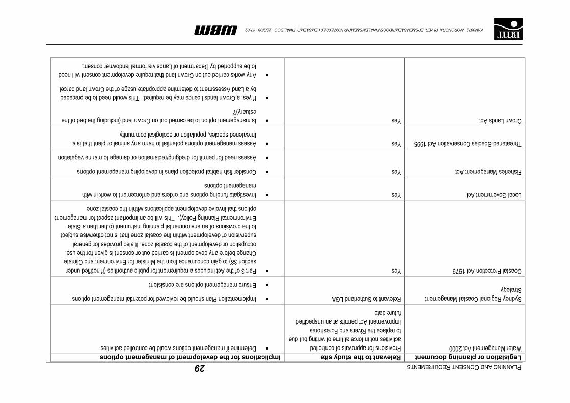
PLANNINGANDCONSENTREQUIREMENTS29
K:\N0972_WORONORA_RIVER_EPS&EMS&EMP\DOCS\FINALEMS&EMP\R.N0972.002.01.EMS&EMP_FINAL.DOC 22/2/08 17:02
Legislation or planning documentRelevant to the study siteImplications for the development of management optionsWater Management Act 2000Provisions for approvals of controlled
activities not in force at time of writing but due to replace the Rivers and Foreshores Improvement Act permits at an unspecified future date
Determine if management options would be controlled activities
Sydney Regional Coastal Management Strategy
Relevant to Sutherland LGAImplementation Plan should be reviewed for potential management options
Ensure management options are consistent
Coastal Protection Act 1979YesPart 3 of the Act includes a requirement for public authorities (if notified under section 38) to gain concurrence from the Minister for Environment and Climate Change before any development is carried out or consent is given for the use, occupation or development of the coastal zone. It also provides for general supervision of development within the coastal zone that is not otherwise subject to the provisions of an environmental planning instrument (other than a State Environmental Planning Policy). This will be an important aspect for management options that involve development applications within the coastal zone
Local Government ActYesInvestigate funding options and orders and enforcement to work in with management options
Fisheries Management ActYesConsider fish habitat protection plans in developing management options
Assess need for permit for dredging/reclamation or damage to marine vegetation
Threatened Species Conservation Act 1995YesAssess management options potential to harm any animal or plant that is a threatened species, population or ecological community
Crown Lands ActYesIs management option to be carried out on Crown land (including the bed of the estuary)?
If yes, a Crown lands licence may be required. This would need to be preceded by a Land Assessment to determine appropriate usage of the Crown land parcel.
Any works carried out on Crown land that require development consent will need to be supported by Department of Lands via formal landowner consent.

PLANNING AND CONSENT REQUIREMENTS 30
K:\N0972_WORONORA_RIVER_EPS&EMS&EMP\DOCS\FINALEMS&EMP\R.N0972.002.01.EMS&EMP_FINAL.DOC 22/2/08 17:02
4.2 Commonwealth legislation
The key piece of commonwealth legislation relevant to the development of an Estuary Management
Plan for the Woronora Estuary is the Environment Protection and Biodiversity Conservation Act 1999
(EPBC). Environmental impact assessments for certain activities are required under the
Environmental Protection and Biodiversity Conservation Act 1999 (Cth) (EPBC Act).
4.3 Other important planning documents, policies and initiatives
4.3.1 Georges River Regional Environmental Plan
The Georges River Regional Environmental Plan (REP) influences the land use, environmental
planning and management decisions taken when land within the wider Georges River catchment is
affected. Development undertaken within the catchment that is likely to affect the environment is
subject to the provisions of the Plan.
The broad aims of the REP are:
Maintain and improve water quality and river flows in the Georges River and its tributaries;
Protect and enhance the environmental quality of the Catchment for the benefit of all users; and
Ensure consistency in the delivery of Ecologically Sustainable development when assessing
development.
More specifically, the REP notes the following objectives:
Preserve and protect significant environments (including mangroves, saltmarsh and seagrass),
bushland and open space corridors, identifying environmentally sensitive area sand providing for
appropriate land use and development controls;
To preserve, enhance and protect estuarine ecosystems;
To ensure development is consistent with the aims of the REP;
To identify land uses with potentially adverse environmental impacts;
To conserve, manage and improve the aquatic environment by providing controls to reduce
pollution entering the watercourses; and
To protect the safety and well being of the local and regional community by improving water
quality and river flows for health and recreation.
Planning principles are highlighted that aim to:
Avoid or minimise disturbance of acid sulphate soils;
Protect banks and foreshores from degradation;
Avoid land degradation including, erosion and sedimentation; loss of native vegetation;
deterioration of soils; pollution of ground or surface waters and adversely impacting sensitive
natural environments;

PLANNING AND CONSENT REQUIREMENTS 31
K:\N0972_WORONORA_RIVER_EPS&EMS&EMP\DOCS\FINALEMS&EMP\R.N0972.002.01.EMS&EMP_FINAL.DOC 22/2/08 17:02
Provision of public access;
Proper management of on-site sewerage systems;
Management of Sewer Overflows through appropriate planning and management of
development within the catchment;
Minimisation of stormwater runoff impacts;
Provision of appropriate buffer widths retained to improve surface runoff;
Improvement of water quality and river flows;
Protection of Wetlands.
The REP places controls on extractive industries and maintenance dredging, works associated with
stormwater management and sewer works, and development in vegetated buffer areas adjacent to
river foreshores.
4.3.2 Sutherland Shire Council Local Environmental Plan, 2006
4.3.2.1 Zoning
The Local Environmental Plan (LEP) provides the broad strategic framework for environmental
planning and development control at a local government level. The LEP deals with local issues such
as land use controls, approval criteria, urban structure, heritage conservation, protection of
environmentally sensitive land and reservation of land for public purposes such as roads and open
space. The land use zonings applicable to the Woronora Estuary are defined by the Sutherland Shire
LEP 2006 (SSLEP2006). This instrument came into effect on 29 November, 2006. Present landuse
zonings around the Woronora Estuary are shown on Figure 4-1.
Residential zonings include the following:
Zone 1: Environmental Housing (Sensitive Land): which encourages residential development
that is sympathetic to the character of and sensitive to the natural environment? This applies to
development along the waterfront;
Zone 3: Environmental Housing (Bushland): which encourages minimisation of risk (primarily
from bushfires) and development that is sympathetic to the natural bushland environment. This
applies to development along ridge tops and adjacent to bushland areas in the catchment; and
Zone 4: Local housing: Allowing for low density urban residential development.
Other areas of particular note, adjacent to the waterway include:
Zone 14: Public Open Space (bushland): which aims to protect public open space areas of
environmental significance and bushland in general. This is typically located upstream of the
Woronora road bridges;
Zone 16: Environmental Protection (waterways): This provides for maintaining recreational use
and access and protecting aquatic environments.
Zone 17: Environmental Protection (low impact rural): This enables low impact rural and
agricultural development on land not suitable for urban development while aiming to protect the
natural environment. This area covers the hillsides below Lucas Heights and Barden Ridge.
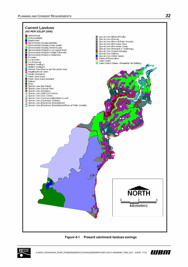
PLANNING AND CONSENT REQUIREMENTS 32
K:\N0972_WORONORA_RIVER_EPS&EMS&EMP\DOCS\FINALEMS&EMP\R.N0972.002.01.EMS&EMP_FINAL.DOC 22/2/08 17:02
Figure 4-1 Present catchment landuse zonings

PLANNING AND CONSENT REQUIREMENTS 33
K:\N0972_WORONORA_RIVER_EPS&EMS&EMP\DOCS\FINALEMS&EMP\R.N0972.002.01.EMS&EMP_FINAL.DOC 22/2/08 17:02
A significant amount of land, including Shackels Estate and large parts of the Forbes, Loftus and Still
Creek corridors are presently classified as “Deferred Matter” meaning that a decision on final zoning
is pending. In this case, reference needs to be made to the zonings of the previous Sutherland Shire
Local Environment Plan (2000).
In addition to the major zonings noted above, Lakewood City Reserve and Prince Edward Park are
zoned as Public Open Space and there are a mixture of other zones including arterial private
recreation, roads (including arterial roads) and special uses.
The bed of the Woronora Estuary is zoned Environmental Protection Waterways (Zone 16) under the
LEP. The objectives of this zone, as set out in the development control table, are:
to recognise the importance of the waterways of Sutherland Shire as an environmental and
recreational asset;
to ensure development is carried out in a way that protects the ecology, scenic value or
navigability of the waterways;
to ensure aquatic environments are not adversely affected by the recreational use of the
waterways;
to allow private development only where it does not reduce or hinder the use of public beaches,
intertidal areas or the waterways;
to provide for viable aquaculture in the waterways.
Development permitted without consent in this zone includes:
beach and foreshore protection works by or on behalf of the Council (if authorised by a plan of
management under the Local Government Act (1993), moorings.
Development by or on behalf of (or authorised by) the Maritime Authority of NSW for the purpose
of maintenance dredging of navigation channels or access channels that provide water access to
a lawful commercial, recreational or public facility, navigation aids.
Development requiring consent in this zone includes:
aquaculture, beach and foreshore protection works (if carried out by a public authority and
authorised by a plan of management under the Local Government Act, 1993, berthing areas,
ferry operations, marinas, passenger transport facilities, public pedestrian access to facilitate
recreational use of the waterway, scientific research associated with native habitats, utility
installations (except for gas holders or generating works), watercraft facilities, wildlife refuges.
Demolition not provided for in development allowed without consent.
4.3.2.2 Development potential
Further development of the Woronora catchment is restricted by zoning and topography. By
comparing the existing zoning and latest air photos it is evident that there are presently four parcels of
undeveloped bushland zoned for residential development. The largest of these, zoned as
Environmental Housing (Sensitive Land), is located south of the low level Woronora Bridge on the
western side of the Estuary in the vicinity of Price’s Circuit.
PLANNING AND CONSENT REQUIREMENTS 34
K:\N0972_WORONORA_RIVER_EPS&EMS&EMP\DOCS\FINALEMS&EMP\R.N0972.002.01.EMS&EMP_FINAL.DOC 22/2/08 17:02
There are also about 150 hectares of land zoned as bushland. As well as zoning, the development
potential of the catchment is also a function of land capability (including topography). The parcel of
rural land is particularly steep with typical slopes in the order of 1V:2H (i.e. 30 degrees).
4.3.3 Development Control Plans
4.3.3.1 Sutherland Shire Environmental Site Management DCP
This DCP applies to any works that may disturb the ground surface and/or affect public safety. The
DCP explains that an Environmental Site Management Plan is required for all Development
Applications.
Section 9 of the DCP outlines Environmental Site Management Standards. This includes general
requirements related to sediment and erosion control and the following list of general requirements:
Compliance with the Protection of the Environment Operations Act (PEOA);
Compliance with Council’s Specifications for site management works;
Installation of erosion and sediment control measures prior to commencement of any activity;
Maintenance of all erosion and sediment control measures;
Hay bales are not to be used as sediment control devices; and
Any sediment deposited on the public way is to be removed immediately.
The Environmental Site Management DCP is a good resource for planners and the public on how to
protect the waterways of the Woronora Estuary from erosion and sediment issues associated with
developments requiring a formal development application. The detailed guidelines, however, are not
statutory and their presence alone will not protect the Estuary. In order for the DCP to be successful,
it would need to be supported by site audits and regulatory actions. In this case, the penalties
described in the Regulatory Provisions of the DCP may not be severe enough to deter potential
breaches of the recommendations made in the DCP.
4.3.3.2 Sutherland Shire Dredging Waterways DCP (SSC, 2002)
The purpose of the Sutherland Shire Council Dredging Waterways Development Control Plan is
“To make the remedial dredging of identified sites within the 7(a) Environmental Protection
(Waterways) zone permissible with development consent, in order to achieve the stated outcomes as
listed in the Schedule of this DCP”
The entire waterway within the estuary is zoned Environmental Protection Waterways. There are two
distinctive parts of the DCP. Part 1 provides an introduction to the plan and its application. Part 2 is
titled “Controls” and comprises the main body of the DCP. This part provides:
An outline of the information that is required to be submitted with an application to dredge a
waterway,
A description of the required consultation to ensure that all likely environmental impacts of the
dredging of a site are identified and appropriately assessed through consultation with relevant
stakeholders prior to determination, and
PLANNING AND CONSENT REQUIREMENTS 35
K:\N0972_WORONORA_RIVER_EPS&EMS&EMP\DOCS\FINALEMS&EMP\R.N0972.002.01.EMS&EMP_FINAL.DOC 22/2/08 17:02
A description of the requirement for an Acid Sulphate Soils Management Plan to accompany
certain dredging development applications.
Management strategies designed in the current document are consistent with the dredging
waterways DCP.
4.3.3.3 Sutherland Shire Waterfront Development DCP (SSC, 2002)
The Waterfront Development DCP applies to all development within the Sutherland Shire that is
below the Foreshore Building Line and/or along the waterfront, above, on, or below Mean High Water
Mark (M.H.W.M). The DCP seeks to allow development that is in harmony with the natural
surroundings, which minimises the impact on the natural environment and acknowledges the
importance of the waterways as a natural public resource. The DCP outlines a number of objectives
and standards that Council must consider in determining development applications. Council can
consider a variation of a standard where it is satisfied that despite the non-compliance, the objectives
of the DCP are still achieved.
The DCP also provides advice on lodging applications with other government agencies for “integrated
development”. Integrated development is development that requires an approval, licence or permit
from a government agency other than the Council. For waterfront development in the Sutherland
Shire Council area this would include:
A permit from DPI (Fisheries) for aquaculture, dredging or reclamation and removal or damage to
marine vegetation;
A permit from DECC to excavate or remove material from within 40m of the waterway;
Owners consent from the Department of Lands for structures and works (including dredging)
below MHWM; and
Comments from the NSW Maritime Authority on proposals likely to impact on navigation.
The DCP also outlines the details that need to be included with a development application for lands
covered by this DCP in the form of a site analysis.
Watercraft facilities, including jetties, ramps and pontoons are a permissible form of development
below MHWM under the Sutherland Shire Council LEP. Controls that apply to these structures are
listed in the DCP. These relate to lengths, widths, applicable standards, stabilisation, colours and
pedestrian access. Controls for berthing areas and sliprails are similarly defined.
Development allowed below the foreshore building line and above MHWM includes:
Boatsheds;
Watercraft facilities;
In ground swimming pools, no higher than 300mm above ground level at any point;
Works, including mechanical work, to enable pedestrian access; and
Landscaping and barbeques.
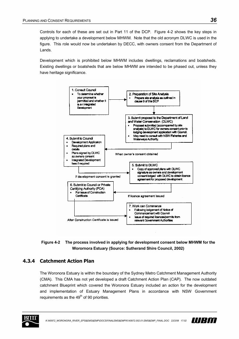
PLANNING AND CONSENT REQUIREMENTS 36
K:\N0972_WORONORA_RIVER_EPS&EMS&EMP\DOCS\FINALEMS&EMP\R.N0972.002.01.EMS&EMP_FINAL.DOC 22/2/08 17:02
Controls for each of these are set out in Part 11 of the DCP. Figure 4-2 shows the key steps in
applying to undertake a development below MHWM. Note that the old acronym DLWC is used in the
figure. This role would now be undertaken by DECC, with owners consent from the Department of
Lands.
Development which is prohibited below MHWM includes dwellings, reclamations and boatsheds.
Existing dwellings or boatsheds that are below MHWM are intended to be phased out, unless they
have heritage significance.
Figure 4-2 The process involved in applying for development consent below MHWM for the
Worornora Estuary (Source: Sutherand Shire Council, 2002)
4.3.4 Catchment Action Plan
The Woronora Estuary is within the boundary of the Sydney Metro Catchment Management Authority
(CMA). This CMA has not yet developed a draft Catchment Action Plan (CAP). The now outdated
catchment Blueprint which covered the Woronora Estuary included an action for the development
and implementation of Estuary Management Plans in accordance with NSW Government
requirements as the 49th of 90 priorities.
PLANNING AND CONSENT REQUIREMENTS 37
K:\N0972_WORONORA_RIVER_EPS&EMS&EMP\DOCS\FINALEMS&EMP\R.N0972.002.01.EMS&EMP_FINAL.DOC 22/2/08 17:02
While a CAP has not yet been developed, a series of Draft Catchment and Management Targets,
which will ultimately form the basis for the CAP were released in May 2006. Briefly, the targets deal
with the following (date of implementation is 2016):
Community: education, better involvement and communication with communities (including
indigenous communities) and stakeholders. Ongoing monitoring and evaluation of key natural
resource indicators.
Biodiversity: a net increase in the coverage of native terrestrial vegetation in the catchment,
including improved condition and connectivity. Better preservation of threatened species and a
decrease in the number, distribution and impact of invasive weeds and pest animals.
Water: Improvements in the health of waterways and an increase in the net extent of wetlands.
Water quality indicators are to be within the relevant guidelines (i.e. ANZECC) and objectives.
There is to be an improvement in the quality and use of groundwater resources and progress is
to be made towards achieving an NSW river flow objective.
Estuary, Coastal and Marine: There is to be an overall improvement in the condition of
estuaries.
Land and Development: This section deals with the overall prevention of land degradation,
including the minimisation of sediment loads to bushland and waterways identification of natural
resource land use constraints.
Although the management targets were in draft form at the time of writing this management study,
they have been considered in the development of management objectives and options to ensure the
best chance of compatibility with the Catchment Action Plan when it is released.
4.3.5 Healthy Rivers Commission Independent Inquiry
The Healthy Rivers Commission (HRC) was established to undertake an independent public inquiry
on river systems selected by the government. The Woronora River was one of the original rivers
identified for an independent inquiry and due to the connection with the Georges River; the scope
was subsequently increased to consider the Georges River as well.
Based on an assessment of the state of the system, the Commission recommended strategies
including the following of relevance to the Woronora:
Increase fish passage;
Integrated local stormwater management and adoption of water sensitive urban design
principles;
Maintaining public ownership and access to foreshore land;
Control excessive erosion and sedimentation;
Replace non-native with native riverbank vegetation;
Adoption of water quality objectives based initially on the ANZECC guideline trigger values;
Collection of river health data;
Establishing a flow regime that will sustain the river’s current ecological condition (an initial flow
regime was recommended for the Woronora);

PLANNING AND CONSENT REQUIREMENTS 38
K:\N0972_WORONORA_RIVER_EPS&EMS&EMP\DOCS\FINALEMS&EMP\R.N0972.002.01.EMS&EMP_FINAL.DOC 22/2/08 17:02
Protection of natural corridor lands in the vicinity of the Woronora Estuary;
Reducing the impact of sewage and stormwater on the water quality of the river; and
Reducing the extent and pace of urban weed infestation in the catchment.
The strategies and objectives outlined by the Healthy Rivers Commission have been considered in
the development of appropriate objectives and management studies.
The Healthy Rivers Commission (HRC) was discontinued in 2004, with the responsibility for ensuring
that the outstanding recommendations of the HRC be implemented passing to the Natural Resources
Commission (NRC). The NRC will audit the Catchment Action Plans produced by the various
Catchment Management Authorities for adequacy in achieving those objectives. Accordingly, the
body that should be consulted with regard to achieving the HRC objectives for the Woronora is the
Sydney Metropolitan CMA.

GOALS AND OBJECTIVES FOR FUTURE MANAGEMENT 39
K:\N0972_WORONORA_RIVER_EPS&EMS&EMP\DOCS\FINALEMS&EMP\R.N0972.002.01.EMS&EMP_FINAL.DOC 22/2/08 17:02
5 GOALS AND OBJECTIVES FOR FUTURE MANAGEMENT
Four (4) overarching goals have been defined for the future management of the Woronora Estuary.
These goals define the aspirations of the community and future direction for management with
respect to the environmental, social, recreational and economic sustainability and viability of the
estuary.
For each goal, a set of well-targeted management objectives has been formulated based on the
values of the estuary and the issues/problems facing the estuary, as presented in the previous
chapters.
The objectives aim to preserve and enhance the estuary’s inherent values while rectifying the
problems facing the estuary.
5.1 Water quality objectives
GOAL1: Water quality of the Woronora Estuary should be suitable for a range of environmental and recreational uses
Objective 1 Reduce the level of pollutant and sediment loads entering the Woronora Estuary from catchment runoff
Objective 2 Reduce pollutant and bacterial loads from on-site sewerage systems
Objective 3 Reduce pollutant and bacterial loads from sewerage overflows
Objective 4 Ensure future activities and development within the catchment do not adversely impact on the estuary
Objective 5 Minimise incidences of illegal dumping of waste into the estuary

GOALS AND OBJECTIVES FOR FUTURE MANAGEMENT 40
K:\N0972_WORONORA_RIVER_EPS&EMS&EMP\DOCS\FINALEMS&EMP\R.N0972.002.01.EMS&EMP_FINAL.DOC 22/2/08 17:02
5.2 Ecology objectives
GOAL2: Habitats of the Woronora River Estuary should support a diversity of estuarine species
Objective 6 Ensure upstream flows are adequate to support ecological function of the estuary
Objective 7 Identify, protect and enhance key habitat areas
Objective 8 Increase fish passage opportunities to allow migration between estuarine and freshwater reaches of the Woronora River
Objective 9 Identify and minimise impacts of recreational activities on estuarine habitats and species
Objective 10 Remove weeds from bushland areas around the estuary
5.3 Waterway and foreshore use objectives
GOAL3: Appropriate use of the waterway and foreshores without compromising natural and cultural values of the Woronora Estuary
Objective 11 Stabilise eroding foreshores, where necessary, to protect assets or infrastructure
Objective 12 Minimise bank erosion impacts of recreational and commuter boating
Objective 13 Improve and maintain amenity of foreshore reserves, where appropriate
Objective 14 Recognise Aboriginal and early European cultural significance of Woronora River Estuary and environs
Objective 15 Provide appropriate navigation access along the Woronora River Estuary
GOALS AND OBJECTIVES FOR FUTURE MANAGEMENT 41
K:\N0972_WORONORA_RIVER_EPS&EMS&EMP\DOCS\FINALEMS&EMP\R.N0972.002.01.EMS&EMP_FINAL.DOC 22/2/08 17:02
5.4 Monitoring and evaluation objectives
GOAL4: Acquire appropriate knowledge to continually improve management of the Woronora River Estuary
Objective 16 Water quality monitoring and analysis to establish ongoing suitability of estuary for environmental and recreational uses
Objective 17 Ecological monitoring to determine existing and future habitat extents, conditions and community structure
Objective 18 Ongoing channel monitoring to identify any compromise in agreed navigational requirements
Objective 19 Periodic review and reconsideration of estuary management goals, objectives and strategies to adapt to changing environmental conditions, community expectations, best practice environmental management and government policy
5.5 Prioritisation of management objectives
The above objectives were provided to members of the Woronora Estuary Management Committee,
and a request made to rank the objectives from 1 through to 19. In total, five completed rankings
were returned and have been analysed.
Each submission was given equal weighting. The resultant scores were tabulated and added to
determine a final prioritisation of management objectives. The final prioritisation of management
objectives is provided in Table 5-1.

GOALS AND OBJECTIVES FOR FUTURE MANAGEMENT 42
K:\N0972_WORONORA_RIVER_EPS&EMS&EMP\DOCS\FINALEMS&EMP\R.N0972.002.01.EMS&EMP_FINAL.DOC 22/2/08 17:02
Table 5-1 Prioritised ranking of Management Objectives
Objective Priority Rank(1 is most important)
OBJECTIVE 1: Reduce the level of pollutant and sediment loads entering the Woronora Estuary from catchment runoff
1
OBJECTIVE 2: Reduce pollutant and bacterial loads from on-site sewerage systems
8
OBJECTIVE 3: Reduce pollutant and bacterial loads from sewerage overflows
2
OBJECTIVE 4: Ensure future activities and development within the catchment do not adversely impact on the estuary
4
OBJECTIVE 5: Minimise incidences of illegal dumping of waste into the estuary
11
OBJECTIVE 6: Ensure upstream flows are adequate to support ecological function of the estuary
10
OBJECTIVE 7: Identify, protect and enhance key habitat areas 7
OBJECTIVE 8: Increase fish passage opportunities to allow migration between estuarine and freshwater reaches of the Woronora River
15
OBJECTIVE 9: Identify and minimise impacts of recreational activities on estuarine habitats and species
14
OBJECTIVE 10: Remove weeds from bushland areas around the estuary
5
OBJECTIVE 11: Stabilise eroding foreshores, where necessary, to protect assets or infrastructure
6
OBJECTIVE 12: Minimise bank erosion impacts of recreational and commuter boating
9
OBJECTIVE 13: Improve and maintain amenity of foreshore reserves, where appropriate
12
OBJECTIVE 14: Recognise Aboriginal and early European cultural significance of Woronora Estuary and environs
18
OBJECTIVE 15: Provide appropriate navigation access along the Woronora Estuary
3
OBJECTIVE 16: Water quality monitoring and analysis to establish ongoing suitability of estuary for environmental and recreational uses
17
OBJECTIVE 17: Ecological monitoring to determine existing and future habitat extents, conditions and community structure
19
OBJECTIVE 18: Ongoing channel depth monitoring to identify any compromise in agreed amenity
16
OBJECTIVE 19: Periodic review and reconsideration of estuary management goals, objectives and strategies to adapt to changing environmental conditions, community expectations, best practice environmental management and government policy
13

DEVELOPMENT, ASSESSMENT AND PRIORITISATION OF POSSIBLE MANAGEMENT OPTIONS/STRATEGIES 43
K:\N0972_WORONORA_RIVER_EPS&EMS&EMP\DOCS\FINALEMS&EMP\R.N0972.002.01.EMS&EMP_FINAL.DOC 22/2/08 17:02
6 DEVELOPMENT, ASSESSMENT AND PRIORITISATION OF POSSIBLE MANAGEMENT OPTIONS/STRATEGIES
6.1 Formulation of Management Options / Strategies
A total of 45 potential management options were formulated and considered to address the 19
management objectives described in Section 5. The management options were developed in
consultation with the Woronora Estuary Management Committee and in response to community and
stakeholder consultation.
The potential management options are presented below under the same categories as the
management objectives: i.e. Water Quality, Ecology, Waterway and Foreshore; and Monitoring and
Evaluation.
6.1.1 Strategies addressing Water Quality Objectives (Objectives 1 to 5)
WQ-1 Emergency Plan for Illegal Dumping. This would include the provision of appropriate
clean up infrastructure at various locations along the River.
WQ-2 End of Pipe Treatment for Stormwater Outlets. Suggestions include provision of
'meshes' or 'grates' at outlet locations. This would primarily be to trap rubbish.
WQ-3 Restrict Waterfront and Ridge Top Development. The restriction of these types of
development could help prevent the exacerbation of any sediment (silt/sand) load
coming off the catchment.
WQ-4 Ongoing upgrade and modifications to stormwater system. This may include source
control in catchment stormwater, the retrofitting of existing stormwater infrastructure
with appropriate stormwater quality improvement devices and sediment traps to protect
the river and minimise erosion by controlling runoff velocities.
WQ-5 Locate and monitor all on-site sewerage systems.
WQ-6 Education program including information dealing with the effect of unsealed surfaces.
WQ-7 More effective policing and penalties for people caught dumping waste illegally into the
Estuary.
WQ-8 Assess and upgrade Sydney Water’s sewerage system to minimise overflows.
WQ-9 Review and revise Council’s stormwater policy. This would include reconsidering total
water cycle, stormwater harvesting and water sensitive urban design, with particular
emphasis on the high erodibility of soils in the catchment and sedimentation in the
Woronora Estuary.
WQ-10 Don't open the fire trail. This option was initially considered as a proactive measure to
prevent additional runoff from the road introducing pollutants and sediment into the
River. This option has now been effectively implemented through rezoning.

DEVELOPMENT, ASSESSMENT AND PRIORITISATION OF POSSIBLE MANAGEMENT OPTIONS/STRATEGIES 44
K:\N0972_WORONORA_RIVER_EPS&EMS&EMP\DOCS\FINALEMS&EMP\R.N0972.002.01.EMS&EMP_FINAL.DOC 22/2/08 17:02
6.1.2 Strategies addressing Ecological Objectives (Objectives 6 to 10)
Ecol-1 Construction of an effective fish passage at the Pass of Sabugal. This area is a priority
barrier to fish migration for the Department of Primary Industries, and is being addressed at
present, although the barrier is not being completely removed.
Ecol-2 Use Bushcare groups to revegetate areas close to and within ecologically sensitive areas.
Ecol-3 Ensure that management of the Woronora Estuary is considered when setting appropriate
environmental flow levels. The Sydney Catchment Authority is responsible for managing
environmental flow releases, which are licensed by the Department of Environment and
Climate Change.
Ecol-4 Targeted bush regeneration at Shackels Estate. There is a proliferation of terrestrial weeds
upon properties "bought back" during the Shackels Estate Acquisition Program. A logistical
problem may be the presence of asbestos from demolished buildings which may hamper
the use of Bushcare to undertake this work.
Ecol-5 Mark key habitat areas at recreational access points to the Estuary.
Ecol-6 Use Bushcare groups to revegetate a riparian buffer zone for the protection of aquatic
ecosystems. Provide more protection to riparian zones.
Ecol-7 Mapping study of estuarine vegetation communities (mangrove, seagrass and saltmarsh).
This can be analysed spatially to determine proximity to any threatening processes (e.g.
stormwater or erosion).
Ecol-8 In developing planning instruments, include upstream buffer zones to allow upward
migration of saltmarsh in response to future sea level rise.
Ecol-9 Foreshore structures designed to minimise impact on aquatic vegetation.
Ecol-10 Additional promotion of Green Web program to protect the important ecological corridor in
the Forbes/Loftus Creek areas.
Ecol-11 Community Education Program on Ecology and Heritage.
6.1.3 Strategies addressing Waterway and Foreshores Objectives (Objectives 11 to 15)
W&F-1 Replace and/or improve speed limit signs. The aim is to ensure that waterway speed limits
are obvious, as boat wake is almost definitely the main cause of foreshore erosion.
W&F-2 Moderate, targeted and ongoing dredging with regular monitoring and appropriate
safeguards. Dredging is the most commonly recommended strategy from community
respondents. The need for dredging has been earmarked at numerous locations along the
entire Estuary, including: near Bonnet Bay, within Forbes Creek, areas upstream of
Deepwater Estate (for fire access) and the entrance shoals.
DEVELOPMENT, ASSESSMENT AND PRIORITISATION OF POSSIBLE MANAGEMENT OPTIONS/STRATEGIES 45
K:\N0972_WORONORA_RIVER_EPS&EMS&EMP\DOCS\FINALEMS&EMP\R.N0972.002.01.EMS&EMP_FINAL.DOC 22/2/08 17:02
W&F-3 Extensive Dredging. One community respondent has made particular reference to the loss
of seawalls following extensive dredging during the 1970’s and 1960’s and this would need
to be considered, along with the loss of seagrass. Some consider that major sedimentation
has resulted from activities during construction of the new Woronora Bridge and that this
needs to be addressed.
W&F-4 Education of boaters on speeding and the damage it does. This could include appropriate
signs at points of access to the Estuary. Leaflets could be distributed at various commercial
and retail establishments on the Estuary.
W&F-5 Change speed limit to 4 knots within the Estuary or review speed limits in the vicinity of
eroding foreshores (introducing no-wake zones where appropriate).
W&F-6 Exclude large boats. Large boats are implicated in causing boat wake erosion. Of
particular note is Council's waste barge.
W&F-7 More frequent and effective policing of waterway users.
W&F-8 Soft protection of eroding foreshores. This may be appropriate in more natural areas such
as those fronting the scout camp or areas fronting mangroves stands.
W&F-9 Hard protection/repair of existing foreshore structures. Areas where this needs to be
targeted include Janalli Reserve (Burnum Burnum Sanctuary) and Prince Edward Park,
where tidal inundation during king tides is also an issue.
W&F-10 Community education program targeting sedimentary processes, enabling people to
understand what causes sedimentation.
W&F-11 Upgrade PEP Wharf – After considerable effort, it appears that this project is now to go
ahead, albeit at a much reduced scale than originally anticipated.
W&F-12 Upgrade public facilities in reserves, e.g. near public boat ramp at Prince Edward Park.
W&F-13 Prepare Council policy on erosion and sedimentation within Catchment (note that this could
be included in a review of the stormwater policy see option WQ-9).
W&F-14 Clean up foreshores campaign to educate and encourage private land owners to take pride
in their community and tidy up areas fronting their properties. This could be done in
conjunction with Council assistance.
W&F-15 Restrict/prevent additional development of foreshores.
W&F-16 Ban wakeboarding.
W&F-17 Construct a right of way fronting all foreshore properties through a buy back scheme.
W&F-18 Construct groynes along southern bank of Forbes Creek near confluence with the
Woronora and dredge to clean up creek and move flood flows away from residential
properties.

DEVELOPMENT, ASSESSMENT AND PRIORITISATION OF POSSIBLE MANAGEMENT OPTIONS/STRATEGIES 46
K:\N0972_WORONORA_RIVER_EPS&EMS&EMP\DOCS\FINALEMS&EMP\R.N0972.002.01.EMS&EMP_FINAL.DOC 22/2/08 17:02
6.1.4 Strategies addressing Monitoring and Evaluation Objectives (Objectives 16 to 19)
M&E-1 Undertake survey on recreational fishing.
M&E-2 Water quality monitoring program.
M&E-3 Ecological health monitoring program.
M&E-4 Hydrosurvey monitoring.
M&E-5 Monitor stormwater quality devices (perhaps to determine origin of any bacterial
parameters).
M&E-6 Periodic review of Plan implementation progress.
6.2 Assessment and prioritisation of possible management options
As presented above, 45 possible management options have been considered to potentially address
the objectives of the Estuary Management Plan. The greatest benefit to the estuary will be gained if
the most effective options are implemented first. Consequently, in order to determine the most
effective options, a multi criteria decision making process has been adopted to compare and prioritise
the 45 management options.
Preferred management options have been determined considering the following criteria:
1. Effectiveness of the option in addressing specific management objectives;
2. Acceptance of the option by community and stakeholders;
3. Cost of the option;
4. Number and priority of objectives that the option meets;
5. Requirements for completion of other management options;
6. Options should include a range of different implementation approaches; and
7. Options should include a range of different implementation timeframes.
For criterion No. 6, ‘different implementation approaches’ include:
Administration;
Education;
Investigation and Review;
DEVELOPMENT, ASSESSMENT AND PRIORITISATION OF POSSIBLE MANAGEMENT OPTIONS/STRATEGIES 47
K:\N0972_WORONORA_RIVER_EPS&EMS&EMP\DOCS\FINALEMS&EMP\R.N0972.002.01.EMS&EMP_FINAL.DOC 22/2/08 17:02
Planning and controls;
On-ground Works; and
Monitoring
For criteria No. 7, the different timeframes considered, include:
Immediately (next 6 – 12 months);
Short Term (1 – 3 years);
Medium term (3-5 years); and
Long term (5-10 years).
Most of the information used in the decision making process was obtained from the community and
stakeholders groups via feedback from questionnaires and discussions, particularly regarding the first
two criteria.
The preferred order of implementation is considered to represent the most effective approach to
managing the estuary from an outcomes viewpoint.
6.2.1 Results of the multi criteria assessment
The result of the multi criteria assessment, including a more detailed description of the way in which
the assessment was undertaken is provided in Appendix A. Figure 6-1 shows a graphical
representation of the relative score for the 45 management strategies, from the highest scoring to the
lowest scoring. These scores take into consideration the number of objectives addressed by each
option, the relative importance (score) of each objective addressed (refer Section 5), the relative cost
of implementation, and the relative effectiveness and acceptability of each option. From Figure 6-1 it
can be seen that management strategy W&F-7, which involves more frequent policing of the
waterway has been given the highest score. The top 10 options include revision of the stormwater
policy and DCP to more directly address development and redevelopment within the Woronora
catchment, the identification and mapping of sensitive habitats, targeted maintenance dredging of the
waterway and other options to protect eroding foreshores.
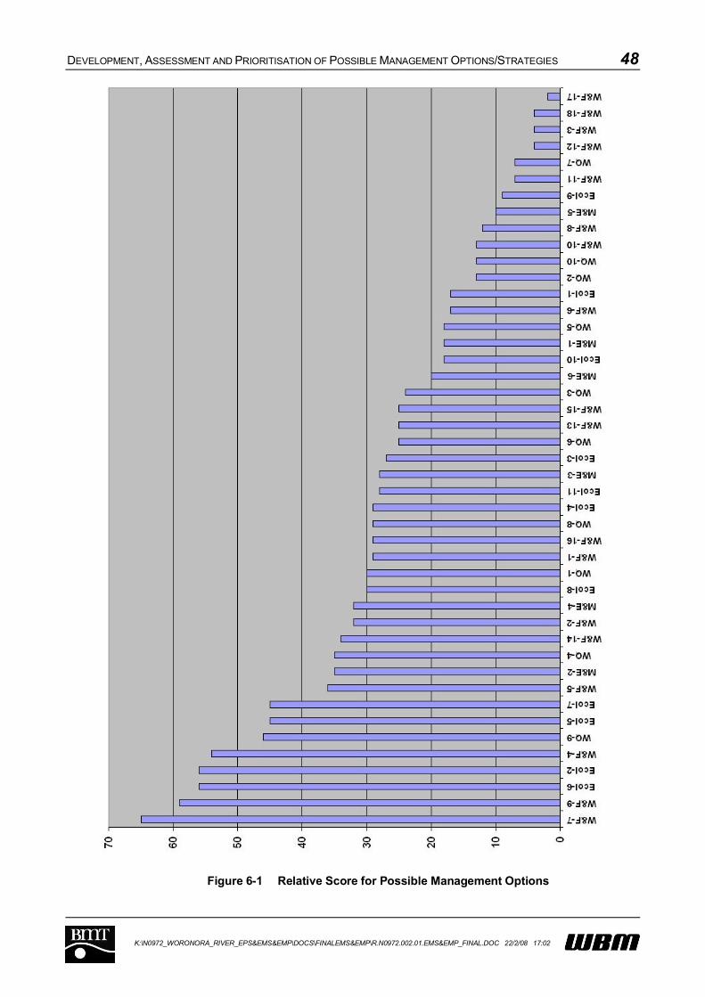
DEVELOPMENT, ASSESSMENT AND PRIORITISATION OF POSSIBLE MANAGEMENT OPTIONS/STRATEGIES 48
K:\N0972_WORONORA_RIVER_EPS&EMS&EMP\DOCS\FINALEMS&EMP\R.N0972.002.01.EMS&EMP_FINAL.DOC 22/2/08 17:02
Figure 6-1 Relative Score for Possible Management Options
DEVELOPMENT, ASSESSMENT AND PRIORITISATION OF POSSIBLE MANAGEMENT OPTIONS/STRATEGIES 49
K:\N0972_WORONORA_RIVER_EPS&EMS&EMP\DOCS\FINALEMS&EMP\R.N0972.002.01.EMS&EMP_FINAL.DOC 22/2/08 17:02
6.2.2 Short-list of preferred management options / strategies
A short list of twenty six (26) management options has been identified based on the results of the
multi criteria assessment (refer Table 6-2). Twenty six options are considered a sensible number for
inclusion in the Estuary Management Plan, when factoring anticipated funding and resource
limitations.
The short-listed options represent those that have scored the highest in the assessment process, and
also represent a range of implementation approaches and timeframes. A number of lower scoring
options were also short-listed, to ensure that all the management objectives were addressed by at
least one management option, or if a higher scoring option was dependent upon the prior completion
of the lower-scoring option. Most options associated with monitoring have also been included to
provide a mechanism for future assessment of the Estuary Management Plan. Where there was
some overlap, aspects of some lower scoring options have been incorporated into the short listed
options (e.g. policing illegal dumping into the River can be achieved at the same time as policing for
speeding at minimal additional cost).
Nineteen (19) potential management options were not short-listed. These options should still be
considered, however, as well as the non-completed short-listed strategies, during future reviews of
the Estuary Management Plan. Reviews of the document will be very important to ensure that the
Plan remains relevant, and is considerate of new technologies, approaches and methods for
environmental management (i.e. adaptive management).
An options and objectives matrix is shown in Table 6-2. This matrix shows the connection between
the defined management objectives and the short-listed management options, as outlined in Table
6-1. From Table 6-2 it can be seen that all objectives are addressed by at least one management
option, while most objectives are addressed by multiple options (maximum of 10 options in respect of
Objective 9). Most options address two or more objectives.
For comparison, the strategies that were eliminated are listed in Table 6-3. This table includes
comments that further justify the exclusion of those strategies at this time.
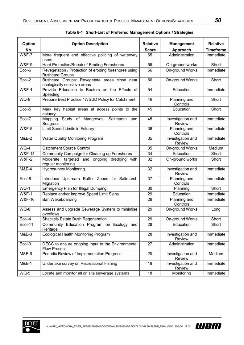
DEVELOPMENT, ASSESSMENT AND PRIORITISATION OF POSSIBLE MANAGEMENT OPTIONS/STRATEGIES 50
K:\N0972_WORONORA_RIVER_EPS&EMS&EMP\DOCS\FINALEMS&EMP\R.N0972.002.01.EMS&EMP_FINAL.DOC 22/2/08 17:02
Table 6-1 Short-List of Preferred Management Options / Strategies
Option
No.
Option Description Relative
Score
Management
Approach
Relative
TimeframeW&F-7 More frequent and effective policing of waterway
users65 Administration Immediate
W&F-9 Hard Protection/Repair of Eroding Foreshores. 59 On-ground works ShortEcol-6 Revegetation / Protection of eroding foreshores using
Bushcare Groups56 On-ground Works Immediate
Ecol-2 Bushcare Groups: Revegetate areas close near ecologically sensitive areas
56 On-ground Works Short
W&F-4 Provide Education to Boaters on the Effects of Speeding
54 Education Immediate
WQ-9 Prepare Best Practice / WSUD Policy for Catchment 46 Planning and Controls
Short
Ecol-5 Mark key habitat areas at access points to the estuary
45 Education Short
Ecol-7 Mapping Study of Mangroves, Saltmarsh and Seagrass
45 Investigation and Review
Immediate
W&F-5 Limit Speed Limits in Estuary 36 Planning and Controls
Immediate
M&E-2 Water Quality Monitoring Program 35 Investigation and Review
Immediate
WQ-4 Catchment Source Control 35 On-ground Works MediumW&F-14 Community Campaign for Cleaning up Foreshores 34 Education ShortW&F-2 Moderate, targeted and ongoing dredging with
regular monitoring 32 On-ground works Short
M&E-4 Hydrosurvey Monitoring. 32 Investigation and Review
Immediate
Ecol-8 Introduce Upstream Buffer Zones for Saltmarsh Migration
37 Planning and Controls
Immediate
WQ-1 Emergency Plan for Illegal Dumping. 30 Planning ShortW&F-1 Replace and/or Improve Speed Limit Signs. 29 Education ImmediateW&F-16 Ban Wakeboarding 29 Planning and
ControlsImmediate
WQ-8 Assess and upgrade Sewerage System to minimise overflows
29 On-ground Works Long
Ecol-4 Shackels Estate Bush Regeneration 29 On-ground Works ShortEcol-11 Community Education Program on Ecology and
Heritage28 Education Short
M&E-3 Ecological Health Monitoring Program 28 Investigation and Review
Immediate
Ecol-3 DECC to ensure ongoing input to the Environmental Flow Process
27 Administration Immediate
M&E-6 Periodic Review of Implementation Progress 20 Investigation and Review
Medium
M&E-1 Undertake survey on Recreational Fishing 18 Investigation andReview
Immediate
WQ-5 Locate and monitor all on site sewerage systems 18 Monitoring Immediate

DEVELOPMENT, ASSESSMENT AND PRIORITISATION OF POSSIBLE MANAGEMENT OPTIONS/STRATEGIES 51
K:\N0972_WORONORA_RIVER_EPS&EMS&EMP\DOCS\FINALEMS&EMP\R.N0972.002.01.EMS&EMP_FINAL.DOC 22/2/08 17:02
Table 6-2 Short-listed Management Options / Strategies and Objective Matrix
Management Objectives
1 2 3 4 5 6 7 8 9 10 11 12 13 14 15 16 17 18 19
WQ-1 √ √
WQ-4 √ √
WQ-5 √
WQ-8 √ √
WQ-9 √ √
Ecol-2 √ √
Ecol-3 √ √
Ecol-4 √
Ecol-5 √ √
Ecol-6 √ √ √
Ecol-7 √ √
Ecol-8 √ √
Ecol-11 √ √
W&F-1 √ √
W&F-2 √ √
W&F-4 √ √ √
W&F-5 √ √ √
W&F-7 √ √ √
W&F-9 √ √ √
W&F-14 √ √
W&F-16 √ √
M&E-1 √
M&E-2 √ √
M&E-3 √ √
M&E-4 √ √
M&E-6 √
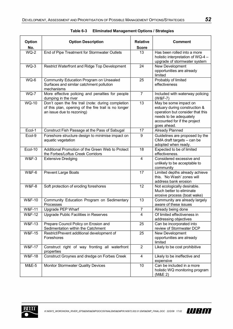
DEVELOPMENT, ASSESSMENT AND PRIORITISATION OF POSSIBLE MANAGEMENT OPTIONS/STRATEGIES 52
K:\N0972_WORONORA_RIVER_EPS&EMS&EMP\DOCS\FINALEMS&EMP\R.N0972.002.01.EMS&EMP_FINAL.DOC 22/2/08 17:02
Table 6-3 Eliminated Management Options / Strategies
Option
No.
Option Description Relative
Score
Comment
WQ-2 End of Pipe Treatment for Stormwater Outlets 13 Has been rolled into a more holistic interpretation of WQ-4 –upgrade of stormwater system
WQ-3 Restrict Waterfront and Ridge Top Development 24 New Development opportunities are already limited
WQ-6 Community Education Program on Unsealed Surfaces and similar catchment pollution mechanisms
25 Probably of limited effectiveness
WQ-7 More effective policing and penalties for people dumping in the river
7 Included with waterway policing (W&F-7)
WQ-10 Don’t open the fire trail (note: during completion of this plan, opening of the fire trail is no longer an issue due to rezoning)
13 May be some impact on estuary during construction & operation but consider that this needs to be adequately accounted for if the project goes ahead.
Ecol-1 Construct Fish Passage at the Pass of Sabugal 17 Already PlannedEcol-9 Foreshore structure design to minimise impact on
aquatic vegetation9 Guidelines are proposed by the
CMA draft targets – can be adopted when ready.
Ecol-10 Additional Promotion of the Green Web to Protect the Forbes/Loftus Creek Corridors
18 Expected to be of limited effectiveness.
W&F-3 Extensive Dredging 4 Considered excessive and unlikely to be acceptable to community
W&F-6 Prevent Large Boats 17 Limited depths already achieve this. ‘No Wash’ zones will address bank erosion
W&F-8 Soft protection of eroding foreshores 12 Not ecologically desirable. Much better to eliminate erosive process (boat wake)
W&F-10 Community Education Program on Sedimentary Processes
13 Community are already largely aware of these issues
W&F-11 Upgrade PEP Wharf 7 Already being doneW&F-12 Upgrade Public Facilities in Reserves 4 Of limited effectiveness in
addressing objectivesW&F-13 Prepare Council Policy on Erosion and
Sedimentation within the Catchment25 Can be incorporated into
review of Stormwater DCPW&F-15 Restrict/Prevent additional development of
Foreshores25 New Development
opportunities are already limited
W&F-17 Construct right of way fronting all waterfront properties
2 Likely to be cost prohibitive
W&F-18 Construct Groynes and dredge on Forbes Creek 4 Likely to be ineffective and expensive
M&E-5 Monitor Stormwater Quality Devices 10 Can be included in a more holistic WQ monitoring program (M&E 2)
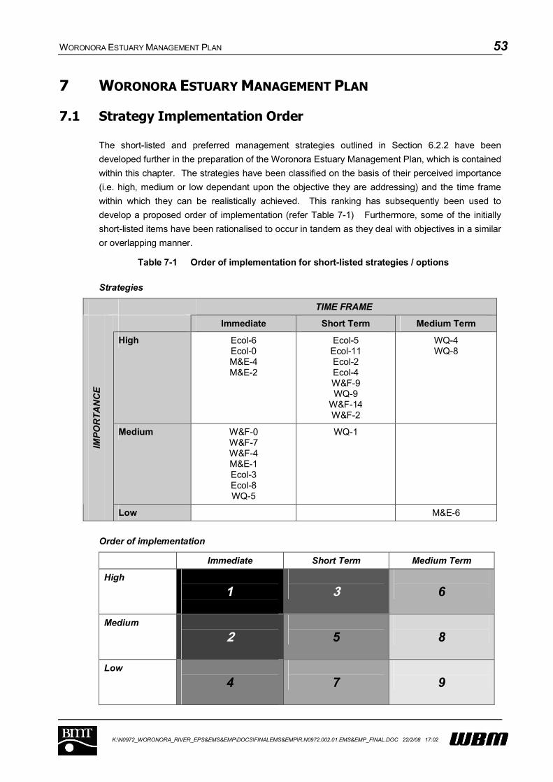
WORONORA ESTUARY MANAGEMENT PLAN 53
K:\N0972_WORONORA_RIVER_EPS&EMS&EMP\DOCS\FINALEMS&EMP\R.N0972.002.01.EMS&EMP_FINAL.DOC 22/2/08 17:02
7 WORONORA ESTUARY MANAGEMENT PLAN
7.1 Strategy Implementation Order
The short-listed and preferred management strategies outlined in Section 6.2.2 have been
developed further in the preparation of the Woronora Estuary Management Plan, which is contained
within this chapter. The strategies have been classified on the basis of their perceived importance
(i.e. high, medium or low dependant upon the objective they are addressing) and the time frame
within which they can be realistically achieved. This ranking has subsequently been used to
develop a proposed order of implementation (refer Table 7-1) Furthermore, some of the initially
short-listed items have been rationalised to occur in tandem as they deal with objectives in a similar
or overlapping manner.
Table 7-1 Order of implementation for short-listed strategies / options
Strategies
TIME FRAME
Immediate Short Term Medium Term
High Ecol-6Ecol-0M&E-4M&E-2
Ecol-5Ecol-11Ecol-2Ecol-4W&F-9WQ-9
W&F-14W&F-2
WQ-4WQ-8
Medium W&F-0W&F-7W&F-4M&E-1Ecol-3Ecol-8WQ-5
WQ-1
IMP
OR
TA
NC
E
Low M&E-6
Order of implementation
Immediate Short Term Medium Term
High
1 3 6
Medium
2 5 8
Low
4 7 9

WORONORA ESTUARY MANAGEMENT PLAN 54
K:\N0972_WORONORA_RIVER_EPS&EMS&EMP\DOCS\FINALEMS&EMP\R.N0972.002.01.EMS&EMP_FINAL.DOC 22/2/08 17:02
7.2 Implementation Schedules
A program for implementation of the Woronora River Estuary Management Plan has been
developed with tasks spanning approximately 5 years. The implementation details for each
separate estuary management strategy are provided in the following schedules.
The implementation details are presented in the form of ‘schedules’, and provide information on
specific actions required to implement each strategy, as well as indicative costs, timeframes,
maintenance requirements, responsibilities for implementation, and ‘performance measures’ to
define the success of implementation. Comments are also provided for each strategy, which
includes background information relevant to the implementation of the strategy and cross-
references to other similar strategies.
The schedules are designed to provide the information in a ‘quick reference’ format to facilitate
implementation and adoption by the responsible authorities.
Strategy M&E-6 is considered to be an integral part of the entire plan. Accordingly, it has not been
included within the implementation tables but is discussed separately within Section 7.5.
WORONORA ESTUARY MANAGEMENT PLAN 55
K:\N0972_WORONORA_RIVER_EPS&EMS&EMP\DOCS\FINALEMS&EMP\R.N0972.002.01.EMS&EMP_FINAL.DOC 22/2/08 17:02
HIGH PRIORITY STRATEGIES
WORONORA ESTUARY MANAGEMENT PLAN 56
K:\N0972_WORONORA_RIVER_EPS&EMS&EMP\DOCS\FINALEMS&EMP\R.N0972.002.01.EMS&EMP_FINAL.DOC 22/2/08 17:02
7.2.1 Ecol-6:Revegetation / Protection of Eroding Foreshores
Priority: High
Description/Discussion:
Riparian vegetation is very important for the protection of key aquatic habitats by providing a buffer,
and the strengthening of foreshores.
A number of strategies utilising the Bushcare resource and involving bush regeneration and
revegetation are considered suitable for the Plan. This particular strategy, involves revegetation
and/or other soft protection of eroding foreshores.
The community based Bushcare program has shown to be a successful strategy for weed removal
and bush regeneration in the Sutherland Shire. The volunteer input by the community is supported
by Council through guidance and supervision by paid Bushcare Officers, training and newsletters.
The groups are entitled to apply for grant funding through initiatives such as the Natural Heritage
Trust and Environmental Trust. The 2004/5 State of the Environment Report for Sutherland Council
reports that the number of Bushcare volunteers in the area continues to grow. The current groups
operating along the Woronora Estuary include:
The Glen Reserve Bushcare Group;
Arthur Place Bushcare Group; since 1997
Jannali Reserve Bushcare Group; since 1993
Jannali Reserve (Tyler Place) Bushcare Group; since 1999
Jannali Reserve Boat Ramp Bushcare Group; since 2000
Nixon Place Bushcare Group; since 1993
Koolangarra Bushcare Group; both since 1992
Forbes Creek Woronora Bushcare Group; since 1996,
Upper Forbes Creek Bushcare Group; since 1996,
Forbes Creek South Bushcare Group; since 2002,
Croston Road Bushcare Group; since 2002,
Azalea Walk Bushcare Group; since 2006.
This strategy requires continued support for the Bushcare program with a focus on sites along the
Woronora.
The strategy will also take opportunities to work with Council’s Greenweb project where appropriate.
The locations of foreshore erosion identified during the Estuary Processes Study are shown on
Figure 7-1 and Figure 7-2. The priority areas are located in the northern part of the Estuary
(Locations 1, 2, 3 and 4). In addition, Location 7 in the southern Estuary is also a priority area.
Strategies would include soft bank remediation methods as appropriate and progressive
revegetation with indigenous species.

WORONORA ESTUARY MANAGEMENT PLAN 57
K:\N0972_WORONORA_RIVER_EPS&EMS&EMP\DOCS\FINALEMS&EMP\R.N0972.002.01.EMS&EMP_FINAL.DOC 22/2/08 17:02
At present, the walking routes identified as part of the Great Kai’mia Way Project do not incorporate
the foreshores in question. Nevertheless, with additional linking trails, there are opportunities to
integrate rehabilitation works with this project.
The Woronora Estuary Management Plan should recognise the importance of riparian zones.
Accordingly, where possible, changes to existing planning instruments should be made to protect
riparian vegetation where it still exists.
Timeframe: Immediately (6-12 Months)
Responsibility: Sutherland Shire Council
Cost: Say $50,000 per year for 5 years
Performance Measure: Length of eroded foreshore (particularly priority foreshore) that is
remediated through soft bank treatment and revegetation.
Actions:
Action Ref No. Action description Underway Complete
Ecol-6-1 Remediate eroding foreshore at Lakewood City
Reserve
Ecol-6-2 Remediate eroding foreshore opposite Bonnet Bay
Boat Ramp
Ecol-6-3 Remediate eroding foreshore at Bonnet Bay Boat
Ramp
Ecol-6-4 Remediate eroding foreshore at Scout Camp,
Opposite Burnum Burnum Sanctuary
Ecol-6-5 Remediate eroding foreshore at Scout Camp, West of
Deepwater Estate
See Also: W&F-1, W&F-7, Ecol-2, Ecol-4
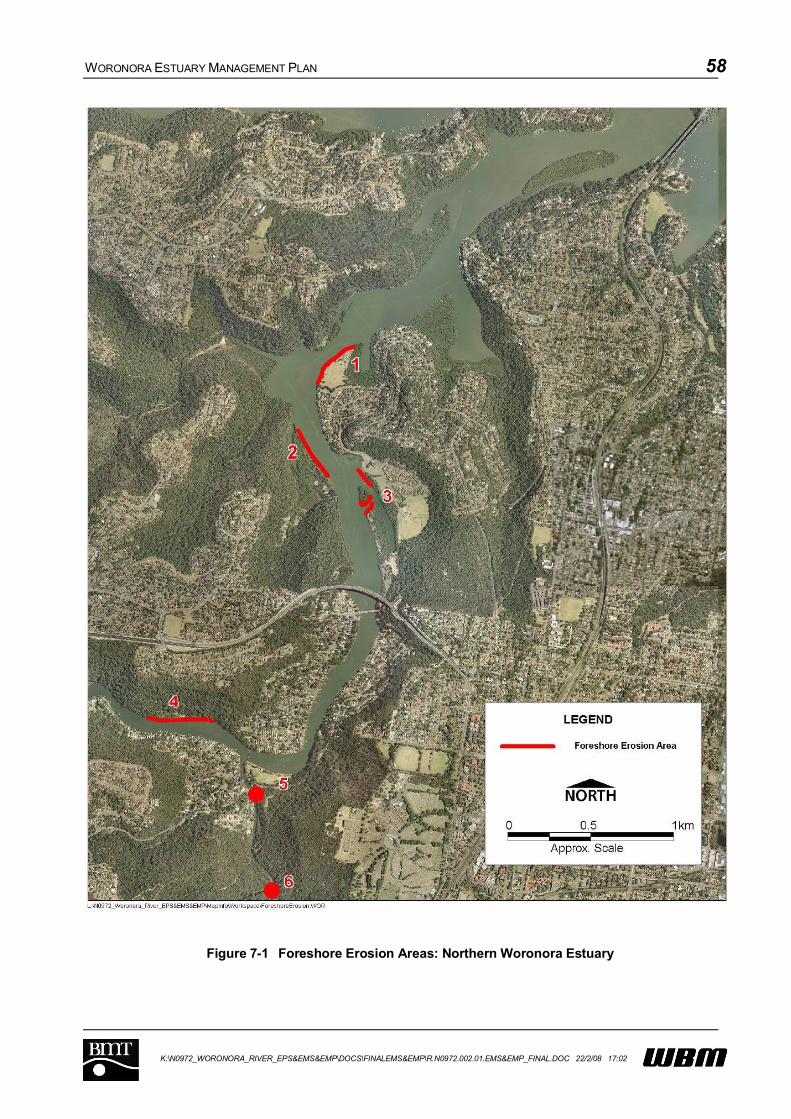
WORONORA ESTUARY MANAGEMENT PLAN 58
K:\N0972_WORONORA_RIVER_EPS&EMS&EMP\DOCS\FINALEMS&EMP\R.N0972.002.01.EMS&EMP_FINAL.DOC 22/2/08 17:02
Figure 7-1 Foreshore Erosion Areas: Northern Woronora Estuary
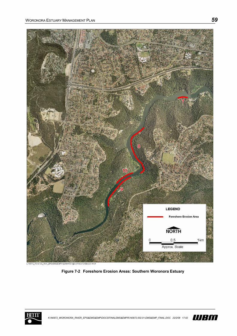
WORONORA ESTUARY MANAGEMENT PLAN 59
K:\N0972_WORONORA_RIVER_EPS&EMS&EMP\DOCS\FINALEMS&EMP\R.N0972.002.01.EMS&EMP_FINAL.DOC 22/2/08 17:02
Figure 7-2 Foreshore Erosion Areas: Southern Woronora Estuary
WORONORA ESTUARY MANAGEMENT PLAN 60
K:\N0972_WORONORA_RIVER_EPS&EMS&EMP\DOCS\FINALEMS&EMP\R.N0972.002.01.EMS&EMP_FINAL.DOC 22/2/08 17:02
7.2.2 Ecol-0: Mapping and monitoring of ecological communities
Priority: High
Description/Discussion:
This strategy incorporates strategies Ecol-8: Mapping Study of Mangroves, Saltmarsh and
Seagrass and M&E-3: Ecological Health Monitoring Program from the Estuary Management Study
(see Chapter 6).
The two complementary strategies aim to improve the data set relating to ecological communities.
The Estuary Processes Study provided maps of saltmarsh and mangroves (based on fieldwork
undertaken during the study and previous research (Pickthall et al, 2004)). These are reproduced
as Figure 7-3 and Figure 7-4.
Future monitoring of the Woronora Estuary should include biological indicators, such as
macroinvertebrate assemblages and the distribution and health of estuarine vegetation. The
distribution and health can be affected by seasonal factors such as wind and turbidity or physical
disturbance through sedimentation or boating.
In particular, the following need to be recognised:
Seagrasses are productive marine flowering plants that stabilise sediments, and provide
habitat, food and shelter for many species of fish and invertebrates including those of economic
importance.
Broad scale changes in seagrass over time need to be assessed more rigorously than is
possible with existing data. For example, it is difficult to determine whether changes between
existing data sets reflect actual changes or differences in mapping methods and effort.
Estuarine wetlands provide habitats for a wide range of biota including species of fisheries
value and conservation significance. Estuarine wetlands also play an important role in
bed/bank stabilisation. Estuarine wetlands are highly productive and are important in the
cycling of nutrients.
There is a need to identify and map the existence of threats to estuarine wetland vegetation,
including boat wake erosion, proximity to stormwater outlets, clearing activities, reclamation
and foreshore structures, the encroachment of mangroves onto saltmarsh areas and weed
invasion to identify areas of valuable vegetation that are at risk.
Coastal Saltmarsh is an endangered ecological community listed on Schedule 1 of the
Threatened Species Conservation Act.
Invertebrates are important ecosystem components, particularly from the perspective of
nutrient cycling and transfer of energy through the food web. Invertebrates also form important
food resources for many bird and fish species. Macroinvertebrates control nutrient fluxes, which
affect benthos community structure and local nutrient concentrations.

WORONORA ESTUARY MANAGEMENT PLAN 61
K:\N0972_WORONORA_RIVER_EPS&EMS&EMP\DOCS\FINALEMS&EMP\R.N0972.002.01.EMS&EMP_FINAL.DOC 22/2/08 17:02
Figure 7-3 Distribution of estuarine vegetation in the fluvial delta geomorphologic zone, Woronora Estuary
Sources: Pickthall et al. 2004 (saltmarsh and Casuarina), WBM (mangroves) current study

WORONORA ESTUARY MANAGEMENT PLAN 62
K:\N0972_WORONORA_RIVER_EPS&EMS&EMP\DOCS\FINALEMS&EMP\R.N0972.002.01.EMS&EMP_FINAL.DOC 22/2/08 17:02
Figure 7-4 Distribution of estuarine vegetation in the riverine and channel geomorphologic zone, Woronora Estuary Sources: Pickthall et al. 2004
(saltmarsh and Casuarina), WBM (mangroves) current study
WORONORA ESTUARY MANAGEMENT PLAN 63
K:\N0972_WORONORA_RIVER_EPS&EMS&EMP\DOCS\FINALEMS&EMP\R.N0972.002.01.EMS&EMP_FINAL.DOC 22/2/08 17:02
The Woronora River estuary is situated within 10 kilometres of Towra Point Nature Reserve, a
Ramsar listed wetland and the Woronora River estuary itself is recognised in the EPBC
protected database as an area likely to contain habitat for two species of migratory wader birds,
namely: Japanese Snipe (Gallinago hardwickii) and; the Painted Snipe (Rostratula benghalensis
s. lat.).
The shoals at the river mouth, Mangrove Island, and Bonnet Bay could all represent locally
important roost and feeding sites for wader birds. This requires further investigation.
Key areas requiring consideration during ecological monitoring include:
Consideration of water quality monitoring results (refer Strategy M&E 2) to determine possible
influences on estuarine community functioning. This should include not only physio-chemical
parameters, but also monitoring of biological indicators such as Capitellidae worm densities (to
assess potential effects on nutrient enrichment), and seagrass depth range assessments (to
assess turbidity and nutrient impacts);
Monitoring of estuarine wetland condition and extent. There is currently little information of long-
term historical changes in these communities, and there is currently no program in place to
assess future changes. Given the importance of these habitats for fisheries, and possible
reductions in saltmarsh extent in the wider region, this should be a priority issue; and
Assessment of wader bird habitats and populations in the study area, and development of
management strategies for these communities. In particular, the impact of disturbance by
boating traffic and pedestrians needs to be considered.
The Woronora Estuary Management Plan should recognise the importance of key habitats to the
overall functioning of the estuary. Accordingly, changes to existing planning instruments should be
made to protect the key aquatic habitats identified by the mapping study. This would also include
protection of riparian buffer zones.
Timeframe: Immediate (6-12 months), Ongoing as required
Responsibility: DPI Fisheries/Sutherland Shire Council
Cost: Say $30,000 per year 5 years
Performance Measure: Reports describing results of ecological monitoring programs.

WORONORA ESTUARY MANAGEMENT PLAN 64
K:\N0972_WORONORA_RIVER_EPS&EMS&EMP\DOCS\FINALEMS&EMP\R.N0972.002.01.EMS&EMP_FINAL.DOC 22/2/08 17:02
Actions:
Action Ref No. Action description Underway Complete
Ecol-0-1 Undertake seasonal estuarine vegetation mapping Ecol-0-2 Undertake periodic macro invertebrate monitoring Ecol-0-3 Undertake periodic seagrass health monitoring Ecol-0-4 Undertake periodic wader bird surveying Ecol-0-5 Undertake threat identification, including water quality
analysis
See Also: M&E-1, M&E-2, Ecol-5

WORONORA ESTUARY MANAGEMENT PLAN 65
K:\N0972_WORONORA_RIVER_EPS&EMS&EMP\DOCS\FINALEMS&EMP\R.N0972.002.01.EMS&EMP_FINAL.DOC 22/2/08 17:02
7.2.3 M&E-4: Hydrosurvey monitoring
Priority: High
Description/Discussion:
Lack of depth in a number of locations throughout the estuary is an issue of significant concern to
many community members. Particular areas include:
Upstream reaches (primarily an access issue for fire fighting) notably an area known as “Kings
Flats”;
In the vicinity of Prince Edward Park Wharf;
Forbes Creek, particularly at the entrance and downstream of the Prince Edward Park Road
Bridge;
Bonnet Bay; and
Downstream of the bridge generally.
Hydrosurvey monitoring is recommended to be undertaken as an identifier of the need for, and as a
precursor to, any maintenance dredging works that may be required (Strategy W&F-2).
A two tiered hydrosurvey program is recommended as follows:
1. Informal hydrosurvey with an echo sounder, to generally monitor and provide feedback on areas
that may need dredging in the future;
2. Following identification of a potential need to dredge, more formal and accurate survey of any
areas of concern, to confirm the need for dredging and the extent of work required.
It is envisaged that the informal survey may be undertaken through the expanded River Keeper
program, as described under Strategy W&F-1. While level 1 survey would be undertaken on a
relatively frequent basis (say, monthly), there would also be scope for the local community to identify
particular areas that are of concern. A fairly simple arrangement utilising an echo sounder, GPS and
a network of permanent tide boards to establish water level at any given time is considered
appropriate for this type of survey.
Following identification of a potential issue, more formal and accurate survey would be undertaken to
identify the spatial extent of the problem. The extent would be determined on the basis of an agreed
depth requirement for navigation.
The local community needs to be consulted regarding the draft requirements of existing vessels to
determine an appropriate navigable depth. However, it is considered that, as a minimum, the vessels
of the Rural Fire Service should be adopted for design to ensure an appropriate level of emergency
access. The present trend for increasing vessel size is not suitable for the Woronora due to its
naturally shallow geomorphology.

WORONORA ESTUARY MANAGEMENT PLAN 66
K:\N0972_WORONORA_RIVER_EPS&EMS&EMP\DOCS\FINALEMS&EMP\R.N0972.002.01.EMS&EMP_FINAL.DOC 22/2/08 17:02
Work on these tasks has been ongoing during the preparation of this plan. It is envisaged that,
following adoption of the Plan, these works will be undertaken as part of overall management of the
Estuary.
Responsibility: Sutherland Shire Council and River Keeper Programme
Timeframe: Immediate (6-12 Months) and Ongoing
Cost: Minimal for informal hydrosurveys, $10,000 per survey for more detailed hydrosurveys.
Performance Measure: Record of informal surveys, and survey reports for detailed hydrosurveys.
Actions:
Action Ref No. Action description Underway Complete
M&E-0-1 Undertake consultation regarding vessel draft
requirements
M&E-0-2 Undertake informal monitoring survey M&E-0-3 Undertake detailed hydrosurvey, if required
See Also: W&F-2

WORONORA ESTUARY MANAGEMENT PLAN 67
K:\N0972_WORONORA_RIVER_EPS&EMS&EMP\DOCS\FINALEMS&EMP\R.N0972.002.01.EMS&EMP_FINAL.DOC 22/2/08 17:02
7.2.4 M&E-2: Water Quality Monitoring
Priority: High
Description/Discussion:
The availability of ongoing and appropriately targeted estuarine water quality data for the Woronora is
an issue of concern. Existing water quality data is biased towards areas of known poor water quality.
This is because the primary source of monitoring data for the estuary is from the Sutherland Shire
Council Strategic Water Quality Monitoring Program (SWAMP), which specifically focussed on
sampling stormwater outlets. The latest data from this program is now at least 4 years old and may
not reflect present day conditions. An assessment of the data collected over 10 years indicated that
water quality in the Woronora Estuary is improving, with the majority of sites showing decreasing
concentrations of selected parameters (including nutrients, bacterial indicators, BOD and heavy
metals) (WBM, 2006).
An ongoing receiving water quality monitoring program, specifically designed to inform management
activities and on-ground works that effectively target sources of nutrients, sediments and faecal
contamination to the Woronora Estuary is to be developed. The monitoring program has two main
aims:
To develop an understanding of background water quality conditions in the estuary;
To inform and assess the effectiveness of management strategies.
The program should integrate with the reinstatement of the SWAMP program (expected to restart in
late 2006) and should also consider inclusion of any data collected by the Sydney Catchment
Authority at the point where freshwater flows into the River (at their station known as “The Needles”,
which is actually upstream of the Pass of Sabugal). The water quality monitoring program should
include event based measurements, designed to capture the response of important parameters to
rainfall events. It should also include monitoring the impact of flow on environmental processes, such
as nuisance algal growth and sediment accumulation.
Parameters that should be measured routinely to derive background data include:
Nutrients;
Dissolved Oxygen;
pH;
Temperature;
Heavy Metals;
Chlorophyll-a;
Turbidity; and
Salinity.
Furthermore, all parameters should be monitored intensively during and following rainfall to gain an
understanding of the estuary’s response to rainfall/runoff events in the catchment.
WORONORA ESTUARY MANAGEMENT PLAN 68
K:\N0972_WORONORA_RIVER_EPS&EMS&EMP\DOCS\FINALEMS&EMP\R.N0972.002.01.EMS&EMP_FINAL.DOC 22/2/08 17:02
Objective setting is an important aspect of a successful monitoring program. This will determine the
parameters tested, sampling locations and frequency. As improvement in ecological health is an
objective of this Estuary Management Plan, consideration should be given to monitoring ecological
responses to declining water quality such as growth of nuisance algae (for example, in the vicinity of
Deepwater Estate). This may assist in identifying nutrient loads to the waterway. This is important as
increases in nutrient loads may not initially be reflected in background water quality monitoring, due to
increased biological uptake.
Given the high concentrations of bacterial indicators in stormwater and the potential for sewage
overflows in the catchment, consideration should be given to using a more robust indicator (such as
faecal sterols or delta Carbon 15) to differentiate between human and other animal sources. This
would provide greater assistance in targeting management options.
In addition, consideration should be given to acquiring some time series data in order to attain a
better understanding of the oxygen balance of the Woronora Estuary. Time series data collected
over diurnal and seasonal timescales at a number of locations would be necessary. It is suggested
that a suitable location for a water quality logging instrument would be in the vicinity of the existing
water level recorder at Woronora Bridge. Water quality readings from this instrument could be made
available on-line. The conditions at the permanent logging instrument should be supplemented by
temporary installations at additional locations.
The Water Quality Monitoring Program will be an important consideration when reviewing the
effectiveness of management strategies aimed at improving water quality within the estuary.
Collected data should be stored in a suitably structured database that makes it easy to compare and
analyse results.
Timeframe: Immediate (6-12 months) and ongoing
Responsibility: Sutherland Shire Council
Cost: Say $30,000 per year for 5 years
Performance Measure: Reports outlining the results of water quality monitoring.
Actions:
Action Ref No. Action description Underway Complete
M&E-2-1 Install permanent, telemetered Water Quality
Instrument (for background WQ Assessments)
M&E-2-2 Design and implement program for temporary water
quality instrument installations
M&E-2-3 Undertake event based water quality monitoring M&E-2-4 Design database and store data. M&E-2-5 Undertake background data analysis and reporting
See Also: M&E-3, WQ-5, WQ-9, WQ-4, WQ-8
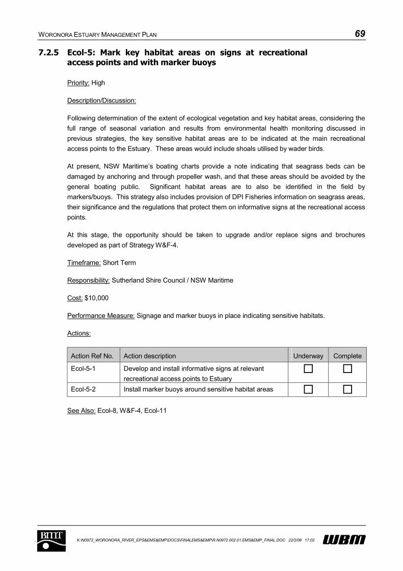
WORONORA ESTUARY MANAGEMENT PLAN 69
K:\N0972_WORONORA_RIVER_EPS&EMS&EMP\DOCS\FINALEMS&EMP\R.N0972.002.01.EMS&EMP_FINAL.DOC 22/2/08 17:02
7.2.5 Ecol-5: Mark key habitat areas on signs at recreational access points and with marker buoys
Priority: High
Description/Discussion:
Following determination of the extent of ecological vegetation and key habitat areas, considering the
full range of seasonal variation and results from environmental health monitoring discussed in
previous strategies, the key sensitive habitat areas are to be indicated at the main recreational
access points to the Estuary. These areas would include shoals utilised by wader birds.
At present, NSW Maritime’s boating charts provide a note indicating that seagrass beds can be
damaged by anchoring and through propeller wash, and that these areas should be avoided by the
general boating public. Significant habitat areas are to also be identified in the field by
markers/buoys. This strategy also includes provision of DPI Fisheries information on seagrass areas,
their significance and the regulations that protect them on informative signs at the recreational access
points.
At this stage, the opportunity should be taken to upgrade and/or replace signs and brochures
developed as part of Strategy W&F-4.
Timeframe: Short Term
Responsibility: Sutherland Shire Council / NSW Maritime
Cost: $10,000
Performance Measure: Signage and marker buoys in place indicating sensitive habitats.
Actions:
Action Ref No. Action description Underway Complete
Ecol-5-1 Develop and install informative signs at relevant
recreational access points to Estuary
Ecol-5-2 Install marker buoys around sensitive habitat areas
See Also: Ecol-8, W&F-4, Ecol-11

WORONORA ESTUARY MANAGEMENT PLAN 70
K:\N0972_WORONORA_RIVER_EPS&EMS&EMP\DOCS\FINALEMS&EMP\R.N0972.002.01.EMS&EMP_FINAL.DOC 22/2/08 17:02
7.2.6 Ecol-11: Community education program on ecology and heritage
Priority: High
Description/Discussion:
The results of community consultation activities have highlighted that appreciation of the ecological
and heritage values of the Woronora Estuary is low in the community.
Following the study and mapping of significant ecological areas, a program for educating the local
community should be developed in order to gain a better understanding of the natural variability of
these communities and the threats to them (Strategy Ecol-8).
Furthermore, the Woronora Estuary has been identified as being rich in heritage value and this is an
aspect of the local environment that is not well recognised by the local community. The significance
of the area to indigenous Australians should be highlighted; however this needs to be done
sensitively to ensure that Aboriginal sites are not placed at risk.
The program will focus primarily on the local community, attempting to foster a sense of
custodianship over the estuary. Specific strategies will include:
Publication of a small booklet outlining both European and Aboriginal Heritage of the Woronora,
development patterns, resulting impacts upon ecological health, measures being undertaken to
mitigate adverse impacts and the ways in which the community can assist to ensure that the
objectives of the Estuary Management Plan are realised. The booklet should focus on the
integrated nature of processes and issues, rather than focussing on specific individual issues.
This booklet could be delivered to each household within the catchment;
Organised boat excursions for interested community members to point out areas of interest,
areas under threat and to explain the impact of various activities within the catchment on the
Estuary. The locations targeted during the boat excursions should be consistent with the
contents of the brochure outlined above. The boat excursions could be facilitated through an
expanded River Keeper program as described in Section 7.2.1;
Distribution of pamphlets containing a précis of the booklet described above for provision to
visitors to the Estuary. This could be made available at the counter of the handful of commercial
establishments that exist along the estuary.
Timeframe: Short Term (1-3 years)
Responsibility: Sutherland Shire Council / Riverkeeper Program
Cost: $30,000 for booklet preparation and distribution
Performance Measure: Publication of booklet and précis; number of residents in receipt of new
information regarding the estuary.
WORONORA ESTUARY MANAGEMENT PLAN 71
K:\N0972_WORONORA_RIVER_EPS&EMS&EMP\DOCS\FINALEMS&EMP\R.N0972.002.01.EMS&EMP_FINAL.DOC 22/2/08 17:02
Actions:
Action Ref No. Action description Underway Complete
Ecol-11-1 Develop and distribute brochure and pamphlet on
ecology and heritage within the Woronora Estuary
Ecol-11-2 Organise and undertake boat excursions through the
River Keeper
See Also: Interacts with most other management strategies
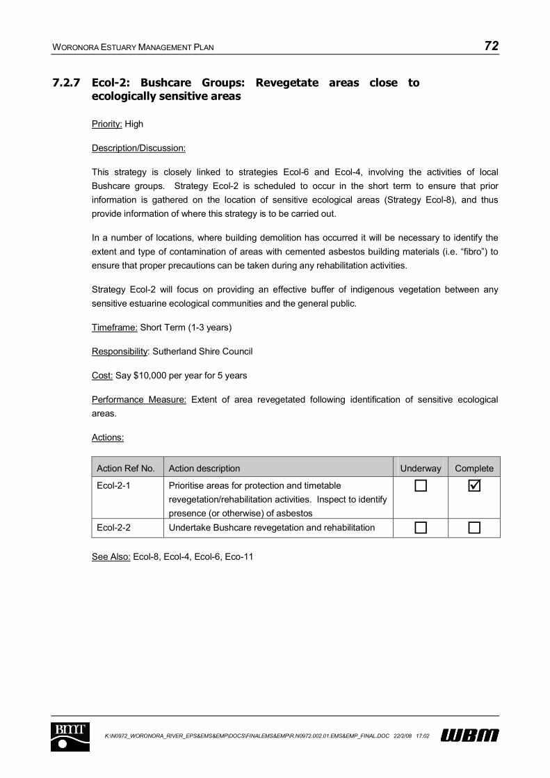
WORONORA ESTUARY MANAGEMENT PLAN 72
K:\N0972_WORONORA_RIVER_EPS&EMS&EMP\DOCS\FINALEMS&EMP\R.N0972.002.01.EMS&EMP_FINAL.DOC 22/2/08 17:02
7.2.7 Ecol-2: Bushcare Groups: Revegetate areas close to ecologically sensitive areas
Priority: High
Description/Discussion:
This strategy is closely linked to strategies Ecol-6 and Ecol-4, involving the activities of local
Bushcare groups. Strategy Ecol-2 is scheduled to occur in the short term to ensure that prior
information is gathered on the location of sensitive ecological areas (Strategy Ecol-8), and thus
provide information of where this strategy is to be carried out.
In a number of locations, where building demolition has occurred it will be necessary to identify the
extent and type of contamination of areas with cemented asbestos building materials (i.e. “fibro”) to
ensure that proper precautions can be taken during any rehabilitation activities.
Strategy Ecol-2 will focus on providing an effective buffer of indigenous vegetation between any
sensitive estuarine ecological communities and the general public.
Timeframe: Short Term (1-3 years)
Responsibility: Sutherland Shire Council
Cost: Say $10,000 per year for 5 years
Performance Measure: Extent of area revegetated following identification of sensitive ecological
areas.
Actions:
Action Ref No. Action description Underway Complete
Ecol-2-1 Prioritise areas for protection and timetable
revegetation/rehabilitation activities. Inspect to identify
presence (or otherwise) of asbestos
Ecol-2-2 Undertake Bushcare revegetation and rehabilitation
See Also: Ecol-8, Ecol-4, Ecol-6, Eco-11

WORONORA ESTUARY MANAGEMENT PLAN 73
K:\N0972_WORONORA_RIVER_EPS&EMS&EMP\DOCS\FINALEMS&EMP\R.N0972.002.01.EMS&EMP_FINAL.DOC 22/2/08 17:02
7.2.8 Ecol-4: Shackels Estate Bush Regeneration
Priority: High
Description/Discussion:
The notable presence of exotic weed infestation along the foreshores of Shackels Estate requires
remediation to prevent the ongoing spread of these introduced species into adjacent bushland.
This strategy is closely linked to strategies Ecol-2 and Ecol-4, involving the activities of local
Bushcare groups. Strategy Ecol-6 is scheduled to occur in the short term due to the potential
difficulties in managing asbestos that remains from the demolition of properties during the Shackels
Estate re-acquisition program.
Strategy Ecol-4 will aim to regenerate bushland in the vicinity of Shackels Estate and will therefore
require ongoing vigilance and repeated weed removal efforts to enable the effective reestablishment
of a healthy indigenous riparian ecosystem. Regeneration works should aim to provide strength or
protection to any lengths of foreshore that are eroding, using “soft” methods that achieve a natural
appearance.
In conjunction with these efforts, it will be necessary to make contact with the remaining residents of
Shackels Estate to discuss vegetation on their properties and offer incentives to replace potentially
invasive species. Particular attention needs to be paid to any noxious weeds that are present in the
first instance.
Additional work will be required where remnant structures at risk of collapse require removal prior to
regeneration activities.
In a number of locations, where building demolition has occurred it will be necessary to identify the
extent and type of contamination of areas with cemented asbestos building materials (i.e. “fibro”) to
ensure that proper precautions can be taken during any regeneration activities.
At the time of writing, this activity is already being undertaken
Timeframe: Short Term (1-3 years)
Responsibility: Sutherland Shire Council/Riverkeeper Program
Cost: $5,000 per year for 5 years
Performance Measure: Extent of land regenerated around Shackels Estate

WORONORA ESTUARY MANAGEMENT PLAN 74
K:\N0972_WORONORA_RIVER_EPS&EMS&EMP\DOCS\FINALEMS&EMP\R.N0972.002.01.EMS&EMP_FINAL.DOC 22/2/08 17:02
Actions:
Action Ref No. Action description Underway Complete
Ecol-4-1 Inspection and progressive removal of remaining
asbestos containing building materials
Ecol-4-2 Inspection and progressive removal of remnant
structures at risk of collapse
Ecol-4-3 Progressive bush regeneration along Shackels Estate
foreshore
Ecol-4-4 Make contact and discuss project with remaining
residents. Develop strategies to minimise introduction
of weeds into native bushland
See Also: Ecol-8, Ecol-2, Ecol-6, Eco-11
WORONORA ESTUARY MANAGEMENT PLAN 75
K:\N0972_WORONORA_RIVER_EPS&EMS&EMP\DOCS\FINALEMS&EMP\R.N0972.002.01.EMS&EMP_FINAL.DOC 22/2/08 17:02
7.2.9 W&F-9: Hard protection/repair of eroding foreshores(private and public)
Priority: High
Description/Discussion:
The protective structures fronting Burnum Burnum Sanctuary (Janalli Reserve) and Prince Edward
Park have been identified as requiring repair. Also, the foreshore stairways fronting the reserve
immediately upstream of the low level bridge (western side) require either repair or replacement.
There is the potential to target all three locations at the same time, using the services of appropriately
qualified maritime structural engineers.
The first stage of the process would involve an assessment of the extent of repair required and
development of an appropriate conceptual design. This would be closely followed by detailed design
and subsequent reconstruction. The following should be considered during the process:
The use of environmentally sensitive methods for bank stabilisation, potentially providing new
habitats for aquatic species;
Enhancement of aquatic ecology and the dissipation of wave energy;
The possibility of integrating the foreshore with wider landscaping of the parklands fronting the
estuary, considering the expressed desire of the community to have facilities upgraded. This
issue was directly considered as part of a preliminary option (W&F-12) but subsequently
eliminated. It is considered that this may be achieved effectively in conjunction with the present
management option. Of particular concern is the unsealed car park in Prince Edward Park,
which is inundated by very high tides.
It may also be expedient to demolish remnant structures at Shackels Estate during construction
activities and in conjunction with Strategy Ecol-4.
Any structural design needs to minimise the impact on marine vegetation and should avoid sheltering
seagrass areas. Any proposal that harms marine vegetation will require an appropriate approval from
DPI Fisheries. An ideal design from the view point of DPI fisheries is a sloping rock rip-rap seawall
and no mortaring. This type of design provides an improved aquatic habitat (when compared to
vertical, mortared sea walls) and helps to absorb wave energy and reduce erosion. Any dredging or
reclamation will require a permit under the Fisheries Management Act, 1994. DPI does not generally
support groynes as a protection measure.
Timeframe: Short Term (1-3 years)
Responsibility: Sutherland Shire Council
Cost: Up to $100,000 per site
Performance Measure: Length of foreshore stabilised through formal foreshore protection works.
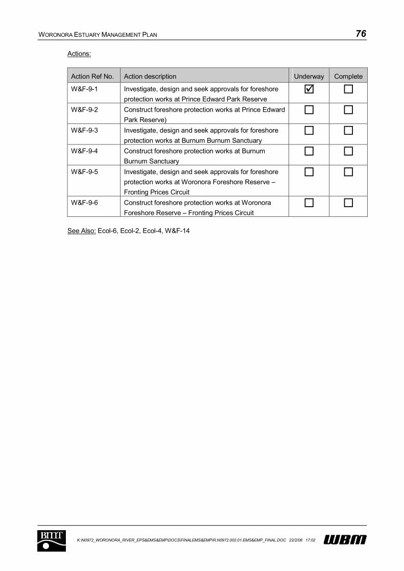
WORONORA ESTUARY MANAGEMENT PLAN 76
K:\N0972_WORONORA_RIVER_EPS&EMS&EMP\DOCS\FINALEMS&EMP\R.N0972.002.01.EMS&EMP_FINAL.DOC 22/2/08 17:02
Actions:
Action Ref No. Action description Underway Complete
W&F-9-1 Investigate, design and seek approvals for foreshore
protection works at Prince Edward Park Reserve
W&F-9-2 Construct foreshore protection works at Prince Edward
Park Reserve)
W&F-9-3 Investigate, design and seek approvals for foreshore
protection works at Burnum Burnum Sanctuary
W&F-9-4 Construct foreshore protection works at Burnum
Burnum Sanctuary
W&F-9-5 Investigate, design and seek approvals for foreshore
protection works at Woronora Foreshore Reserve –
Fronting Prices Circuit
W&F-9-6 Construct foreshore protection works at Woronora
Foreshore Reserve – Fronting Prices Circuit
See Also: Ecol-6, Ecol-2, Ecol-4, W&F-14

WORONORA ESTUARY MANAGEMENT PLAN 77
K:\N0972_WORONORA_RIVER_EPS&EMS&EMP\DOCS\FINALEMS&EMP\R.N0972.002.01.EMS&EMP_FINAL.DOC 22/2/08 17:02
7.2.10 WQ-9: Review/revise stormwater policy considering erodibility of soils within catchment
Priority: High
Description/Discussion:
To ensure that future development (including intensification of existing developed areas) has minimal
impact on the condition of the estuary, Council’s existing stormwater policies and Development
Control Plans (DCP’s) should be reviewed and revised, as appropriate, to consider the erodible
character of the Woronora Catchment.
The present DCP includes implementation of Water Sensitive Urban Design and Integrated Water
Cycle Management (including stormwater harvesting and reuse), which are aimed at reducing
stormwater runoff flows and loads from urban areas by adopting a range of options including
rainwater tanks (with reuse for garden and lawn watering, toilet flush, laundry, hot water services, etc)
and infiltration systems. However, the existing DCP applies across the whole Sutherland Shire LGA.
There are opportunities to include more stringent controls in the Woronora Estuary’s catchment to
further control the export of coarse sediment from the catchment.
Council could also encourage the adoption of WSUD and other on-site stormwater controls for
existing developments through a range of financial incentives (including rainwater tank rebates, rate
reductions etc), or other market-based incentives.
Timeframe: Short Term (1-3 years)
Responsibility: Sutherland Shire Council
Cost: Minimal for DCP review; dependent on extent and scope of incentives offered.
Performance Measure: Revised and adopted DCP for Woronora catchment to impose more stringent
limits on coarse sediment export associated with development.
Actions:
Action Ref No. Action description Underway Complete
WQ-9-1 Investigate potential for Woronora specific
modifications to Council Development Control Plans
WQ-9-2 Implement changes to DCP as appropriate WQ-9-3 Introduce a range of incentives for community to
implement best practice water management within
existing developments.
See Also: M&E-2, WQ-4
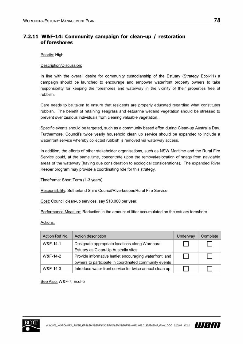
WORONORA ESTUARY MANAGEMENT PLAN 78
K:\N0972_WORONORA_RIVER_EPS&EMS&EMP\DOCS\FINALEMS&EMP\R.N0972.002.01.EMS&EMP_FINAL.DOC 22/2/08 17:02
7.2.11 W&F-14: Community campaign for clean-up / restoration of foreshores
Priority: High
Description/Discussion:
In line with the overall desire for community custodianship of the Estuary (Strategy Ecol-11) a
campaign should be launched to encourage and empower waterfront property owners to take
responsibility for keeping the foreshores and waterway in the vicinity of their properties free of
rubbish.
Care needs to be taken to ensure that residents are properly educated regarding what constitutes
rubbish. The benefit of retaining seagrass and estuarine wetland vegetation should be stressed to
prevent over zealous individuals from clearing valuable vegetation.
Specific events should be targeted, such as a community based effort during Clean-up Australia Day.
Furthermore, Council’s twice yearly household clean up service should be expanded to include a
waterfront service whereby collected rubbish is removed via waterway access.
In addition, the efforts of other stakeholder organisations, such as NSW Maritime and the Rural Fire
Service could, at the same time, concentrate upon the removal/relocation of snags from navigable
areas of the waterway (having due consideration to ecological considerations). The expanded River
Keeper program may provide a coordinating role for this strategy.
Timeframe: Short Term (1-3 years)
Responsibility: Sutherland Shire Council/Riverkeeper/Rural Fire Service
Cost: Council clean-up services, say $10,000 per year.
Performance Measure: Reduction in the amount of litter accumulated on the estuary foreshore.
Actions:
Action Ref No. Action description Underway Complete
W&F-14-1 Designate appropriate locations along Woronora
Estuary as Clean-Up Australia sites
W&F-14-2 Provide informative leaflet encouraging waterfront land
owners to participate in coordinated community events
W&F-14-3 Introduce water front service for twice annual clean up
See Also: W&F-7, Ecol-5

WORONORA ESTUARY MANAGEMENT PLAN 79
K:\N0972_WORONORA_RIVER_EPS&EMS&EMP\DOCS\FINALEMS&EMP\R.N0972.002.01.EMS&EMP_FINAL.DOC 22/2/08 17:02
7.2.12 W&F-2: Limited navigation dredging, as-required
Priority: High
Description/Discussion:
A review of the available historical information and community expectation for a navigable waterway
highlights that the community’s perception of what constitutes a natural situation for the Woronora
Estuary has been influenced by historical dredging practices. There is limited hard evidence showing
how the estuary may change in the short term, as a result of floods and tides.
The balance of hard evidence in the form of both aerial and ground based photography shows that
the Woronora Estuary has always been prone to shallow depths and mobile shoals. Nevertheless,
there has almost definitely been an acceleration of sediment exported from the catchment during
urban development stages and there is a need for navigation along the Estuary, particularly for the
purpose of commuting from upstream areas not serviced by roads and for access by the Rural Fire
Services vessel.
This Strategy aims to maintain minimum navigable depth within the waterway, and requires input
from Strategy M&E-4 which monitors the navigable depths. This strategy has been prioritised to
occur during the short term to ensure that an adequate monitoring regime is established, and that
realistic and achievable needs of the community relating to navigation are determined as part of
Strategy M&E-4.
Undertaking substantial dredging immediately, as suggested by some community members, is not
recommended given the following risks:
The dredging may prove to be ineffective as the dynamics of the shoal development rates at
different locations within the estuary are not fully understood; and
The dredging may be excessive, resulting in a waste of funding and potentially unnecessary
damage to foreshore structures and important estuarine habitats.
Generally, dredging is not seen as an effective management strategy in addressing problems within
an Estuary. However, given enough evidence to inform a targeted, limited and cautious dredging
strategy geared at addressing localised navigation requirements, it would appear to be a suitable
measure in the Woronora Estuary.
Once the requirements for navigable depth are established and a need for dredging determined, an
ongoing program of maintenance dredging could be implemented.
There are many competing values that need to be considered as part of any maintenance dredging
program, namely:
What is a reasonable navigable depth?;
What permits are required and how can the approval process be streamlined? For example, a
licence will be permit will be required from the NSW Lands Department under the Crown Lands
Act, while a permit may also be required from DPI Fisheries if seagrass is to be harmed or
removed;

WORONORA ESTUARY MANAGEMENT PLAN 80
K:\N0972_WORONORA_RIVER_EPS&EMS&EMP\DOCS\FINALEMS&EMP\R.N0972.002.01.EMS&EMP_FINAL.DOC 22/2/08 17:02
What is the potential impact on seagrasses? (this will not be known until the seasonal variation
has been established under Strategy Ecol-8);
What types of dredging plant are available? (small, flexible and environmentally friendly plant are
preferred);
Are there any issues relating to Acid Sulfate Soils?;
How will the dredged spoil be handled and processed (is there available space)?; and
What is the economic value of dredged spoil and can it be sold for profit to offset the cost of the
program?
A feasibility study is required prior to the completion of any dredging works and this study can be
initiated in conjunction with Strategy M&E-4. It must be realised that this is not the only way that
sedimentation will be targeted. The source control measures described as part of Strategy WQ-4 are
also important. Nevertheless, control of export from the surrounding urban catchment will not remove
the need for ongoing maintenance dredging and navigation may still be impaired from time to time.
A responsive, flexible approach is required to manage navigation within areas that are known to
become shallow from time to time. Overall, it is recommended that the scale of maintenance
dredging be kept as small as practicably possible. Relatively major dredging may be required
following any significant flood events, but the significance of individual floods is not yet fully
understood.
At the time of writing, targeted dredging works are planned for navigation purposes within the
Estuary. The aim of this strategy is to streamline this process and develop a framework for
undertaking dredging in a systematic and responsive manner.
Timeframe: Short Term (1-3 years)
Responsibility: Sutherland Shire Council, NSW Maritime, Lands Department
Cost: Ranging between $100,000 and $500,000 depending on scope of works.
Performance Measure: Maintenance of a navigable waterway that enables access for key estuary
users.
Actions:
Action Ref No. Action description Underway Complete
W&F-2-1 Undertake feasibility study incorporating monitoring
data available under strategy M&E-4 and considering
logistics of the approval process, physical removal
W&F-2-2 Develop framework for responsive, targeted dredging
W&F-2-3 Undertake dredging as and when required (including
necessary repeat approvals)
See Also: Ecol-8, M&E-4
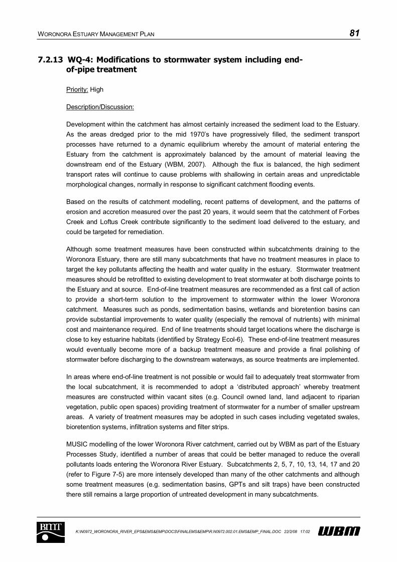
WORONORA ESTUARY MANAGEMENT PLAN 81
K:\N0972_WORONORA_RIVER_EPS&EMS&EMP\DOCS\FINALEMS&EMP\R.N0972.002.01.EMS&EMP_FINAL.DOC 22/2/08 17:02
7.2.13 WQ-4: Modifications to stormwater system including end-of-pipe treatment
Priority: High
Description/Discussion:
Development within the catchment has almost certainly increased the sediment load to the Estuary.
As the areas dredged prior to the mid 1970’s have progressively filled, the sediment transport
processes have returned to a dynamic equilibrium whereby the amount of material entering the
Estuary from the catchment is approximately balanced by the amount of material leaving the
downstream end of the Estuary (WBM, 2007). Although the flux is balanced, the high sediment
transport rates will continue to cause problems with shallowing in certain areas and unpredictable
morphological changes, normally in response to significant catchment flooding events.
Based on the results of catchment modelling, recent patterns of development, and the patterns of
erosion and accretion measured over the past 20 years, it would seem that the catchment of Forbes
Creek and Loftus Creek contribute significantly to the sediment load delivered to the estuary, and
could be targeted for remediation.
Although some treatment measures have been constructed within subcatchments draining to the
Woronora Estuary, there are still many subcatchments that have no treatment measures in place to
target the key pollutants affecting the health and water quality in the estuary. Stormwater treatment
measures should be retrofitted to existing development to treat stormwater at both discharge points to
the Estuary and at source. End-of-line treatment measures are recommended as a first call of action
to provide a short-term solution to the improvement to stormwater within the lower Woronora
catchment. Measures such as ponds, sedimentation basins, wetlands and bioretention basins can
provide substantial improvements to water quality (especially the removal of nutrients) with minimal
cost and maintenance required. End of line treatments should target locations where the discharge is
close to key estuarine habitats (identified by Strategy Ecol-6). These end-of-line treatment measures
would eventually become more of a backup treatment measure and provide a final polishing of
stormwater before discharging to the downstream waterways, as source treatments are implemented.
In areas where end-of-line treatment is not possible or would fail to adequately treat stormwater from
the local subcatchment, it is recommended to adopt a ‘distributed approach’ whereby treatment
measures are constructed within vacant sites (e.g. Council owned land, land adjacent to riparian
vegetation, public open spaces) providing treatment of stormwater for a number of smaller upstream
areas. A variety of treatment measures may be adopted in such cases including vegetated swales,
bioretention systems, infiltration systems and filter strips.
MUSIC modelling of the lower Woronora River catchment, carried out by WBM as part of the Estuary
Processes Study, identified a number of areas that could be better managed to reduce the overall
pollutants loads entering the Woronora River Estuary. Subcatchments 2, 5, 7, 10, 13, 14, 17 and 20
(refer to Figure 7-5) are more intensely developed than many of the other catchments and although
some treatment measures (e.g. sedimentation basins, GPTs and silt traps) have been constructed
there still remains a large proportion of untreated development in many subcatchments.

WORONORA ESTUARY MANAGEMENT PLAN 82
K:\N0972_WORONORA_RIVER_EPS&EMS&EMP\DOCS\FINALEMS&EMP\R.N0972.002.01.EMS&EMP_FINAL.DOC 22/2/08 17:02
Figure 7-5 Sub-catchments and existing treatment devices for the Woronora River Estuary

WORONORA ESTUARY MANAGEMENT PLAN 83
K:\N0972_WORONORA_RIVER_EPS&EMS&EMP\DOCS\FINALEMS&EMP\R.N0972.002.01.EMS&EMP_FINAL.DOC 22/2/08 17:02
All proposed measures should be subject to an appropriate maintenance and cleaning regime.
Timeframe: Medium Term (3- 5 years)
Responsibility: Sutherland Shire Council
Cost: In excess of $500,000 depending on number and type of treatment measures implemented.
Performance Measure: Amount of stormwater treated by additional water quality control measures
within the catchment.
Actions:
Action Ref No. Action description Underway Complete
WQ-4-1 Detailed assessment of stormwater system draining to
Woronora Estuary (includes identification and
assessment of any decommissioned ponds or basins)
WQ-4-2 Prioritise locations for end-of-pipe treatment WQ-4-3 Prioritise locations for distributed treatments WQ-4-4 Progressive design and construction of end-of-pipe
treatments
WQ-4-5 Progressive design and construction of distributed
treatments
See Also: M&E-2, M&E-4

WORONORA ESTUARY MANAGEMENT PLAN 84
K:\N0972_WORONORA_RIVER_EPS&EMS&EMP\DOCS\FINALEMS&EMP\R.N0972.002.01.EMS&EMP_FINAL.DOC 22/2/08 17:02
7.2.14 WQ-8: Assess and upgrade sewerage system to minimise overflows
Priority: High
Description/Discussion:
The last publicly available document detailing the distribution and frequency of sewerage overflows
was Sydney Water’s Environmental Impact Statement for the Sewer Overflows Licensing Project in
1998. Since that time, the reporting of overflow frequencies and volumes by Sydney Water to the
Environment Protection Authority (now Department of Environment and Conservation) has been
limited to totals for the entire Cronulla Ocean Outfall Sewerage System of which the catchment of the
Woronora Estuary contributes only a small part.
Information is not available that relates specifically to the Woronora Estuary’s catchment from Sydney
Water. In the absence of this information, it is not possible to provide a targeted response to the
issue of sewer overflows within the catchment. Whilst Sydney Water has provided information to
Sutherland Council on the location of sewerage infrastructure, this data could not be included
specifically in this plan due to restrictions placed upon it by Sydney Water.
Accordingly, as an initial step in the determination of the contribution of sewer overflows to pollution
within the estuary, it will be necessary to obtain the relevant information from Sydney Water. In
addition, Sydney Water should be urged to participate with the Estuary Management Committee in an
integrated manner to ensure that the objectives of the Estuary Management Plan are achieved.
An assessment of sewage overflows from the reticulated system and a corresponding risk
assessment should be undertaken for the Woronora Estuary. Once risks have been quantified,
actions should be implemented to reduce overflows. The required actions will be determined as more
is understood regarding the source of pollution to the Estuary (as part of Strategy M&E-2) but may
include:
Undertaking works to increase the hydraulic capacity and/or reduce leakage from the network,
and
Developing response plans so that overflows are rapidly identified and managed.
Timeframe: Medium Term (3-5 years)
Responsibility: Woronora Estuary Management Committee / Sydney Water
Cost: Say $200,000, depending on the extent of infrastructure works required
Performance Measure: Reduction in the frequency and quantity of sewer overflows directed to the
Woronora Estuary.
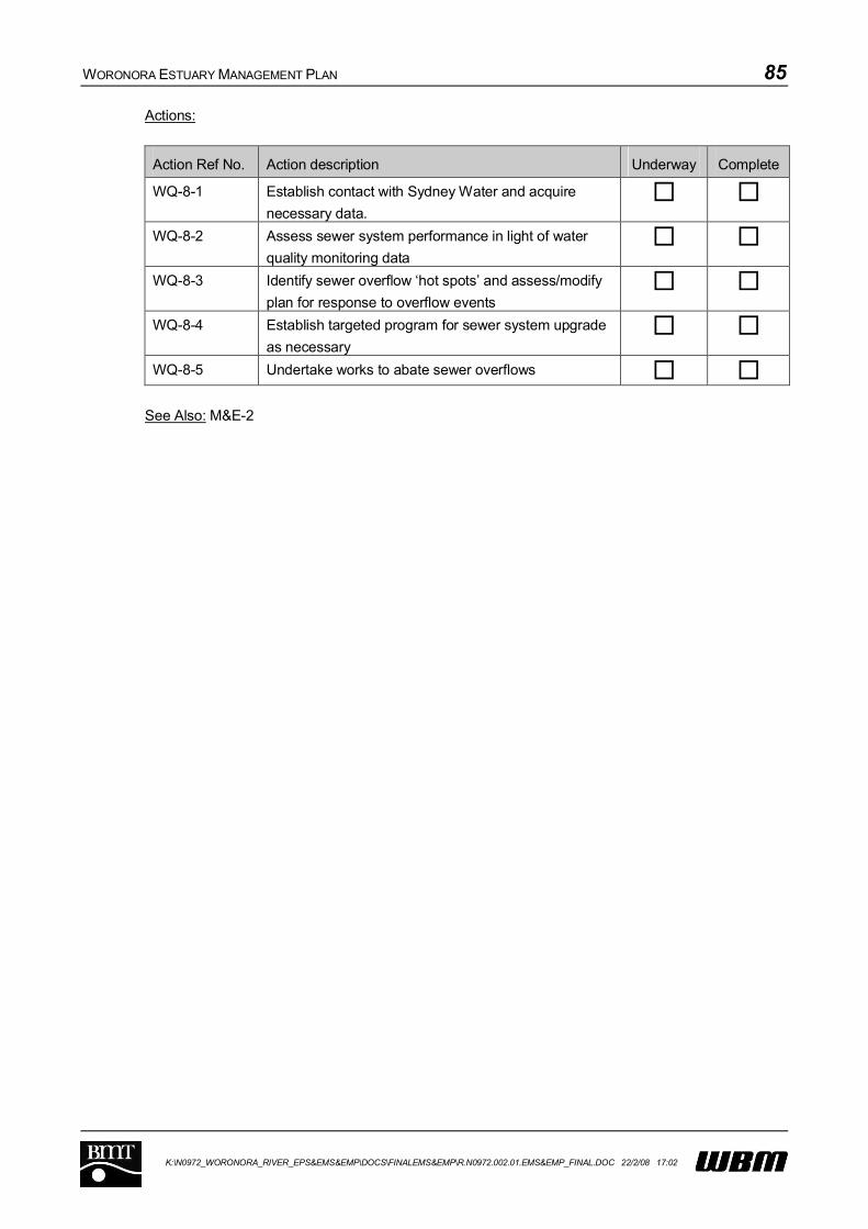
WORONORA ESTUARY MANAGEMENT PLAN 85
K:\N0972_WORONORA_RIVER_EPS&EMS&EMP\DOCS\FINALEMS&EMP\R.N0972.002.01.EMS&EMP_FINAL.DOC 22/2/08 17:02
Actions:
Action Ref No. Action description Underway Complete
WQ-8-1 Establish contact with Sydney Water and acquire
necessary data.
WQ-8-2 Assess sewer system performance in light of water
quality monitoring data
WQ-8-3 Identify sewer overflow ‘hot spots’ and assess/modify
plan for response to overflow events
WQ-8-4 Establish targeted program for sewer system upgrade
as necessary
WQ-8-5 Undertake works to abate sewer overflows
See Also: M&E-2

WORONORA ESTUARY MANAGEMENT PLAN 86
K:\N0972_WORONORA_RIVER_EPS&EMS&EMP\DOCS\FINALEMS&EMP\R.N0972.002.01.EMS&EMP_FINAL.DOC 22/2/08 17:02
MEDIUM PRIORITY STRATEGIES
WORONORA ESTUARY MANAGEMENT PLAN 87
K:\N0972_WORONORA_RIVER_EPS&EMS&EMP\DOCS\FINALEMS&EMP\R.N0972.002.01.EMS&EMP_FINAL.DOC 22/2/08 17:02
7.2.15 W&F-0: General boating restrictions
Priority: Medium
Description/Discussion:
This strategy incorporates the following strategies identified during the management study:
Strategy W&F-1: Replace or Improve Speed Limit Signs;
Strategy W&F-5: Limit Speeds in Estuary; and
W&F-16 Ban Wakeboarding.
All of the above options are aimed at reducing the amount of boat wash that impacts upon foreshores
within the estuary. Both the community and government agencies are concerned about the impact
that boat wake is having on eroding foreshores within the estuary.
The use of power boats moving at speed and generating large wake are seen as incompatible with
aspects of the estuary that are held valuable by the community. Furthermore, in some areas, the
impact of boat wake is directly undermining valuable ecological areas.
The dynamic nature of shoals within the Woronora Estuary is also a safety issue when shallow areas
encroach upon navigation channels. Reduced speed would mitigate this safety issue.
An extract from the relevant current NSW Maritime Boating Chart (available from
www.maritime.nsw.gov.au) is provided as Figure 7-6. The speed zones should be modified from
those shown to comprise a no-wash zone throughout the entire estuary. The extension of the no
wash area is consistent with the original recommendations of the Healthy Rivers Commission (1999).
The proposed changes would cover all areas of erosion identified in the Estuary Processes Study
(Appendix F). Initially, speed limits are to be maintained as they are at present, with a review being
undertaken in future to determine whether the objectives of this strategy are being achieved. In the
opinion of NSW Maritime, the shallow draught vessels which use the Woronora tend to create more
wash at 4 knots than at 8 knots, meaning that a reduction in speed limits is likely to be detrimental in
terms of reducing bank erosion.
In conjunction with the change to navigation restrictions, speed limit signs should be replaced as
necessary, and their visibility, placement and spacing reviewed to ensure that restrictions are clear
throughout the estuary. The introduction of a global no-wash zone will effectively exclude wake
boarding from within the estuary.
Community acceptance of this strategy could be enhanced by the education initiatives proposed by
Strategy W&F 4. Opposition may arise from the point of view of those using the river to commute
from upstream, particularly if transit times are increased.

WORONORA ESTUARY MANAGEMENT PLAN 88
K:\N0972_WORONORA_RIVER_EPS&EMS&EMP\DOCS\FINALEMS&EMP\R.N0972.002.01.EMS&EMP_FINAL.DOC 22/2/08 17:02
Figure 7-6 Extract from NSW Maritime Boating Map
Timeframe: Immediate (6-12 months)
Responsibility: NSW Maritime
Cost: Say $10,000 for new signage, maps/brochures and education.
Performance Measure: Reduction of boat wake within the estuary.

WORONORA ESTUARY MANAGEMENT PLAN 89
K:\N0972_WORONORA_RIVER_EPS&EMS&EMP\DOCS\FINALEMS&EMP\R.N0972.002.01.EMS&EMP_FINAL.DOC 22/2/08 17:02
Actions:
Action Ref No. Action description Underway Complete
W&F-0-1 Review and adjust navigation restriction signs,
replacing dilapidated signs as necessary
W&F-0-2 Adjust boating maps to reflect changes to navigation
restrictions
See Also: W&F-7, W&F-4, Ecol-5

WORONORA ESTUARY MANAGEMENT PLAN 90
K:\N0972_WORONORA_RIVER_EPS&EMS&EMP\DOCS\FINALEMS&EMP\R.N0972.002.01.EMS&EMP_FINAL.DOC 22/2/08 17:02
7.2.16 W&F-7: More frequent and effective policing of waterway users
Priority: Medium
Description/Discussion:
An issue raised by a number of responses to the community consultation was the inability of present
policing arrangements to respond quickly to complaints from residents with relation to speeding
vessels.
In conjunction with the initiatives described in Strategy W&F-0, a strategy for more effective policing
of the Woronora Estuary is proposed.
The Georges River “Riverkeeper” is funded by Hurstville, Sutherland, Rockdale, Kogarah and
Bankstown Council (i.e. the Georges River Combined Council Committee, GRCCC) and the NSW
Maritime Authority. Accordingly, the Riverkeeper is presently responsible for a much wider area than
the Woronora Estuary, including Botany Bay, the Georges River and its tributaries.
NSW Maritime is responsible for monitoring compliance with speed restrictions on the navigable
waters of the Woronora River. The Riverkeeper has delegated powers to act as a Compliance
Officer for NSW Maritime in enforcing speed restrictions. This strategy requires use of the
Riverkeeper to increase the frequency of compliance campaigns along the Woronora River,
particularly in conjunction with other measures proposed as part of this Plan.
While the River Keeper program is responsible for facilitating environmental remediation and
protective works, the role also overlaps with that of a normal Boating Services Officer of the Maritime
Authority.
Extension of the Riverkeeper program to enable more of a focus on the Woronora Estuary is
recommended and necessary for a number of strategies contained within the Woronora Estuary
Management Plan. One of the areas that should be targeted is the policing of revised navigation
restrictions for the Estuary, especially during its introductory stages. This needs to occur in
conjunction with appropriate community education (W&F-4). Depending on the degree to which the
River Keeper program can be feasibly extended, the River Keeper can provide additional assistance
in the implementation of other strategies. The policing of illegal dumping, a management option that
was eliminated by multi-criteria analysis undertaken as part of the estuary management study, could
also be addressed by the River Keeper.
The effectiveness of this strategy would be difficult to measure. One way of gauging the
effectiveness of this strategy would be to undertake community consultation to determine whether the
strategy is considered useful and/or effective.
Timeframe: Immediate (6-12 months)
Responsibility: Sutherland Shire Council/ River Keeper / NSW Maritime
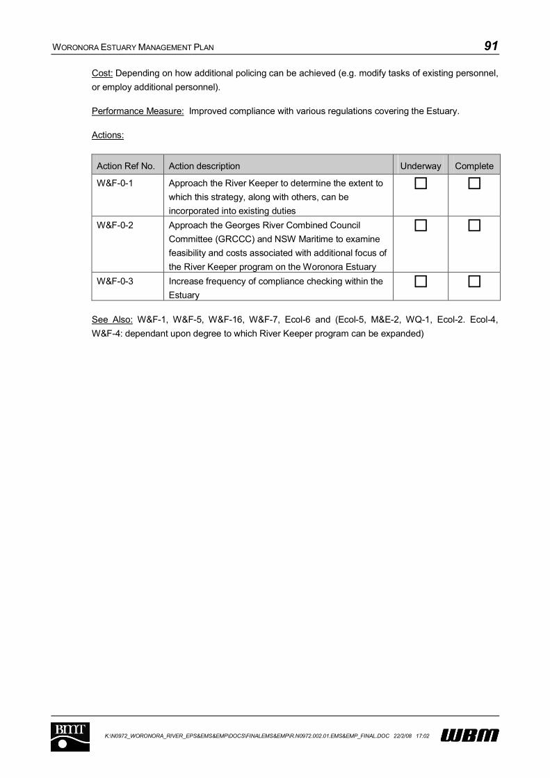
WORONORA ESTUARY MANAGEMENT PLAN 91
K:\N0972_WORONORA_RIVER_EPS&EMS&EMP\DOCS\FINALEMS&EMP\R.N0972.002.01.EMS&EMP_FINAL.DOC 22/2/08 17:02
Cost: Depending on how additional policing can be achieved (e.g. modify tasks of existing personnel,
or employ additional personnel).
Performance Measure: Improved compliance with various regulations covering the Estuary.
Actions:
Action Ref No. Action description Underway Complete
W&F-0-1 Approach the River Keeper to determine the extent to
which this strategy, along with others, can be
incorporated into existing duties
W&F-0-2 Approach the Georges River Combined Council
Committee (GRCCC) and NSW Maritime to examine
feasibility and costs associated with additional focus of
the River Keeper program on the Woronora Estuary
W&F-0-3 Increase frequency of compliance checking within the
Estuary
See Also: W&F-1, W&F-5, W&F-16, W&F-7, Ecol-6 and (Ecol-5, M&E-2, WQ-1, Ecol-2. Ecol-4,
W&F-4: dependant upon degree to which River Keeper program can be expanded)
WORONORA ESTUARY MANAGEMENT PLAN 92
K:\N0972_WORONORA_RIVER_EPS&EMS&EMP\DOCS\FINALEMS&EMP\R.N0972.002.01.EMS&EMP_FINAL.DOC 22/2/08 17:02
7.2.17 W&F-4: Provide information on the effects of speeding
Priority: Medium
Description/Discussion:
In order to educate and gather community support for the initiatives proposed to reduce speed limits
in the estuary, educational strategies are recommended to inform estuary users of the reasons for the
change. The recommended approach uses two strategies:
Publishing an informative brochure explaining the need for the changes;
Erecting signs at strategic locations to provide information to boaters.
It is envisaged that signage will comprise constructed stands, within which changeable informative
posters can be displayed.
The information contained within the brochure and on the signs would be similar. The following are
considered appropriate:
Background to the scientific investigations and the reasons for the speed limit changes (including
photographic evidence of damage);
Provision of information on the importance of riparian zones;
A description of the speed limits that are being imposed and the areas where they are to be
enforced;
A map showing the location of identified eroding foreshores and sensitive ecological areas. While
these have been provided by the Estuary Processes Study, it will be necessary for the mapping
of sensitive ecological areas to be upgraded following more detailed study (See Strategy Ecol-8).
Guidance on the contents of the informative material can be gained by accessing existing NSW
Maritime publications such as:
“Leave only Water in your Wake” which addresses a range of environmental considerations such
as erosion caused by wake, seagrass sensitivity and the spread of Caulerpa taxifolia,
the stickers titled “Navigation Rules/Advisory Signs/Warning Signals/Remember”, which explains
the meaning of “No Wash Zones”, and
the poster “Excessive wash can cause nuisance, annoyance or danger”.
There are limited opportunities within the estuary for the distribution of brochures, given the limited
commercial development adjacent to the waterway. Nevertheless, brochures should be delivered to
each household along the Estuary, and made freely available from outlets such as the Star Boat
Shed, Woronora RSL, Caravan Park and food outlets in Woronora. Efforts should be made to
distribute the brochure to any new residents moving into the area and the brochure should be made
available for download from an appropriate location on the internet.
Signs should be prominently installed at all formal access locations to the estuary, including the boat
ramps at Burnum Burnum Sanctuary and Bonnet Bay, and adjacent to the Wharf at Prince Edward
Park Road, as well as land-based car parks used by residents of water-access only dwellings at
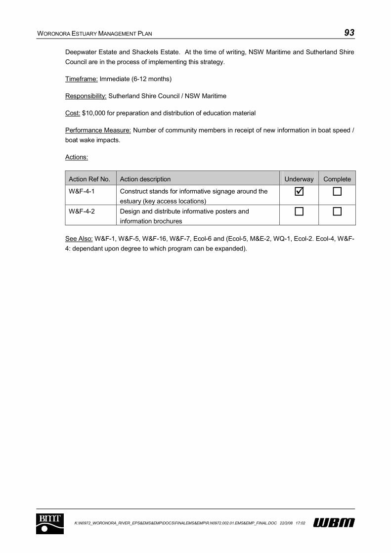
WORONORA ESTUARY MANAGEMENT PLAN 93
K:\N0972_WORONORA_RIVER_EPS&EMS&EMP\DOCS\FINALEMS&EMP\R.N0972.002.01.EMS&EMP_FINAL.DOC 22/2/08 17:02
Deepwater Estate and Shackels Estate. At the time of writing, NSW Maritime and Sutherland Shire
Council are in the process of implementing this strategy.
Timeframe: Immediate (6-12 months)
Responsibility: Sutherland Shire Council / NSW Maritime
Cost: $10,000 for preparation and distribution of education material
Performance Measure: Number of community members in receipt of new information in boat speed /
boat wake impacts.
Actions:
Action Ref No. Action description Underway Complete
W&F-4-1 Construct stands for informative signage around the
estuary (key access locations)
W&F-4-2 Design and distribute informative posters and
information brochures
See Also: W&F-1, W&F-5, W&F-16, W&F-7, Ecol-6 and (Ecol-5, M&E-2, WQ-1, Ecol-2. Ecol-4, W&F-
4: dependant upon degree to which program can be expanded).

WORONORA ESTUARY MANAGEMENT PLAN 94
K:\N0972_WORONORA_RIVER_EPS&EMS&EMP\DOCS\FINALEMS&EMP\R.N0972.002.01.EMS&EMP_FINAL.DOC 22/2/08 17:02
7.2.18 M&E-1: Undertake survey on recreational fishing
Priority: Medium
Description/Discussion:
A recreational fishing study is required to determine fishing compliance rates and general estuary fish
stocks; and to fill an important data gap relating to the Woronora Estuary. Options for completion of
this study include the engagement of an ecological consultant or university. In addition, the
Woronora Fishing Club can be approached to gauge interest in participating.
Methodologies used could include site audits and diary based systems for a selected sample of
fishers or a creel survey. Regardless of the approach adopted, the survey needs to be well designed
to be meaningful and DPI fisheries should be contacted to discuss the survey design.
Information collected through this study will inform future management strategies including the need
for education, ways to increase compliance and whether there are any requirements relating to
restricting recreational fishing.
The recreational fishing study should:
Establish the recreational fishing effort and catch in the Estuary;
Examine the potential impact on specific species of importance (commercially important or
threatened);
Determine if any species may be affected by overfishing; and
Determine whether there is a need for temporary or seasonal bans or modifications to limits.
Responsibility for enforcing any bans would rest with DPI Fisheries along with additional
investigations to determine the response of fish stocks to any bans.
Timeframe: Immediate (6 – 12 months)
Responsibility: Department of Primary Industry: Fisheries
Cost: $30,000
Performance Measure: Documented results of fisher survey
Actions:
Action Ref No. Action description Underway Complete
M&E-1-1 Design recreational survey and determine appropriate
means of undertaking that survey
M&E-1-2 Undertake survey, possibly through engagement of
external organisation
See Also: M&E-3

WORONORA ESTUARY MANAGEMENT PLAN 95
K:\N0972_WORONORA_RIVER_EPS&EMS&EMP\DOCS\FINALEMS&EMP\R.N0972.002.01.EMS&EMP_FINAL.DOC 22/2/08 17:02
7.2.19 Ecol-3: Ensure that Woronora Estuary is considered during Environmental Flow determination
Priority: Medium
Description/Discussion:
The control of environmental flow releases from Woronora Dam is not the responsibility of the
Woronora Estuary Management Committee. However, it is necessary that the needs of the Estuary
are taken into account when decisions are being made regarding environmental flow releases from
the Dam. The Sydney Catchment Authority controls environmental flow releases at Woronora Dam
and these releases are licensed by the Department of Environment and Climate Change. It is
important that the needs of the Woronora Estuary are considered when establishing or revising the
environmental flow release strategy. An appropriate monitoring strategy should be established to
determine the ongoing impact upon the estuary.
Timeframe: Immediate (6 – 12 months)
Responsibility: DECC
Cost: Staff time only
Performance Measure: Environmental flows assessment for the Woronora River that duly considers
the needs of the estuary
Actions:
Action Ref No. Action description Underway Complete
Ecol-3-1 Establish contact with appropriate individuals within
DECC to ensure input from the Estuary Management
Committee is provided to the Environmental Flow
Release determination process
See Also: M&E-1, Ecol-6, Ecol-8, M&E-4, M&E-2

WORONORA ESTUARY MANAGEMENT PLAN 96
K:\N0972_WORONORA_RIVER_EPS&EMS&EMP\DOCS\FINALEMS&EMP\R.N0972.002.01.EMS&EMP_FINAL.DOC 22/2/08 17:02
7.2.20 Ecol-8: Modify planning instruments to provide for landward migration of saltmarsh communities
Priority: Medium
Description/Discussion:
In recognition of the regional importance of saltmarsh communities, planning controls need to be
implemented to enable migration of these communities, wherever possible, as sea levels rise in
response to global warming. This strategy includes three stages:
Identification of areas where saltmarsh vegetation could migrate as a result of sea level rise;
Modification of Planning Instruments to allow for protection of those areas;
Physical protection of those areas where appropriate
Timeframe: Short Term (1-3 years)
Responsibility: SCC
Cost: Staff time only
Performance Measure: Adopted Planning Instrument that accommodates future translation of
saltmarsh areas.
Actions:
Action Ref No. Action description Underway Complete
Ecol-8-1 Identify opportunities for salt marsh migration Ecol-8-2 Modify Planning Instruments (e.g. LEP or place-based
DCP)
Ecol-8-3 Provide physical protection as necessary
See Also: Ecol-6, Ecol-0, Ecol-5, Ecol-11, Ecol-2

WORONORA ESTUARY MANAGEMENT PLAN 97
K:\N0972_WORONORA_RIVER_EPS&EMS&EMP\DOCS\FINALEMS&EMP\R.N0972.002.01.EMS&EMP_FINAL.DOC 22/2/08 17:02
7.2.21 WQ-5: Locate and monitor all on-site sewage systems
Priority: Medium
Description/Discussion:
Some areas within the catchment are still using on-site sewage management systems (e.g. septic
tanks). These sewage systems have the potential to act as a source of human specific pathogens
and nutrients to the estuary. An assessment of the condition of on-site sewage treatment systems
along with the surrounding soil conditions (e.g. permeability), should be undertaken to determine the
likely risks of the system to pollute the environment.
Systems should be assessed against the requirements of clauses 41-46 of the Local Government
(General) Regulation which commenced in September 2005.
Systems that are found to be inappropriate should be repaired or replaced by landholders.
Alternatives may include aerated holding tanks with regular pump-out, surface disposal and
evaporation, or a combination of treatments. Consideration could also be given to connecting some
lots to the sewerage system (particularly in areas where a reticulated service exists).
It is important that Sutherland Council obtains records of those properties not serviced by reticulated
sewerage from Sydney Water, if they are not held in house by Sutherland Council and places them
onto a digital database to record monitoring activities over time.
Timeframe: Immediate (6 – 12 months)
Responsibility: Sutherland Shire Council, landholders
Cost: Staff time only
Performance Measure: Records of on-site sewage system audits, and number of replacements for
systems that are non-compliant.
Actions:
Action Ref No. Action description Underway Complete
WQ-5-1 Locate/collect data on all on-site systems within
catchment
WQ-5-2 Establish database for inspection/monitoring of system
performance
WQ-5-3 Undertake regular monitoring as required WQ-5-4 Repair or replace systems that are non-compliant
See Also: M&E-2

WORONORA ESTUARY MANAGEMENT PLAN 98
K:\N0972_WORONORA_RIVER_EPS&EMS&EMP\DOCS\FINALEMS&EMP\R.N0972.002.01.EMS&EMP_FINAL.DOC 22/2/08 17:02
7.2.22 WQ-1: Emergency Plan for illegal dumping / pollution events
Priority: Medium
Description/Discussion:
Although the issue of illegal dumping or accidental spillage of pollutants into the waterway was not
identified as being particularly frequent or detrimental to the health of the Estuary, both the Estuary
Management Committee and individuals responding to the community questionnaire have identified
this issue as one of concern. Potential illegal dumping activities that have been identified during the
consultation process include:
discharge of sewage;
discharge of paint waste;
dumping of household waste; and
potential spillage of chemicals resulting from road accidents.
Clearly, the extent of waste disposal can vary significantly depending on the nature of the
spillage/dumping event. The purpose of this management strategy is to develop a targeted
Emergency Management Plan for potentially harmful pollution events, if it is found to be necessary.
As a first step in developing an appropriate Emergency Management Plan, contact should be made
with the New South Wales Fire Brigade to gain an understanding of the services that they currently
provide, and to ensure that any efforts are coordinated. Furthermore, contact should be made with
the local emergency management committee.
A risk assessment of different types of potential spillage or dumping events that may occur needs to
be undertaken to enable an effectively targeted Emergency Management Plan.
Additional measures required to address this issue may include:
Provision of spillage booms and absorbent materials in the vicinity of boat access points to the
Estuary;
Consideration of employing a model to predict movement of the spill;
Development of protocols to handle any spillage events; and
Provision and advertisement of an emergency number for the community to use to report any
pollution events. Relevant information can be provided on signs at the boat access points to the
Estuary and in the brochure described as part of Strategy Ecol-11.
The plan should consider, in particular, the location of any sensitive ecological communities.
Timeframe: Short-term (1-3 years)
Responsibility: Sutherland Shire Council / NSW Maritime / New South Wales Fire Brigade

WORONORA ESTUARY MANAGEMENT PLAN 99
K:\N0972_WORONORA_RIVER_EPS&EMS&EMP\DOCS\FINALEMS&EMP\R.N0972.002.01.EMS&EMP_FINAL.DOC 22/2/08 17:02
Cost: Say $10,000 for Plan preparation
Performance Measure: Adopted Plan outlining Emergency procedures that would protect the estuary
from damage.
Actions:
Action Ref No. Action description Underway Complete
WQ-1-1 Make contact with NSW Fire Brigade and Local
Emergency Management Committee to determine
responsibilities
WQ-1-2 Undertake risk assessment WQ-1-3 Prepare emergency response plan and undertake
necessary on ground works to facilitate
implementation of the Plan.
See Also: W&F-1, W&F-7, Ecol-11, W&F-14.
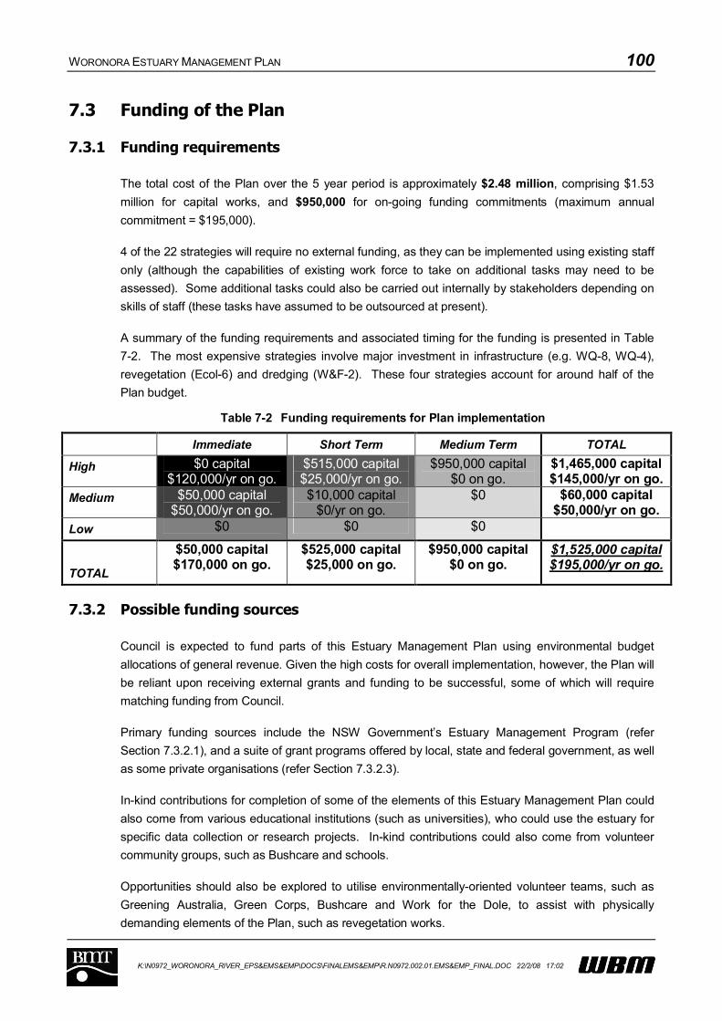
WORONORA ESTUARY MANAGEMENT PLAN 100
K:\N0972_WORONORA_RIVER_EPS&EMS&EMP\DOCS\FINALEMS&EMP\R.N0972.002.01.EMS&EMP_FINAL.DOC 22/2/08 17:02
7.3 Funding of the Plan
7.3.1 Funding requirements
The total cost of the Plan over the 5 year period is approximately $2.48 million, comprising $1.53
million for capital works, and $950,000 for on-going funding commitments (maximum annual
commitment = $195,000).
4 of the 22 strategies will require no external funding, as they can be implemented using existing staff
only (although the capabilities of existing work force to take on additional tasks may need to be
assessed). Some additional tasks could also be carried out internally by stakeholders depending on
skills of staff (these tasks have assumed to be outsourced at present).
A summary of the funding requirements and associated timing for the funding is presented in Table
7-2. The most expensive strategies involve major investment in infrastructure (e.g. WQ-8, WQ-4),
revegetation (Ecol-6) and dredging (W&F-2). These four strategies account for around half of the
Plan budget.
Table 7-2 Funding requirements for Plan implementation
Immediate Short Term Medium Term TOTAL
High $0 capital$120,000/yr on go.
$515,000 capital$25,000/yr on go.
$950,000 capital$0 on go.
$1,465,000 capital$145,000/yr on go.
Medium $50,000 capital$50,000/yr on go.
$10,000 capital$0/yr on go.
$0 $60,000 capital$50,000/yr on go.
Low $0 $0 $0
TOTAL
$50,000 capital$170,000 on go.
$525,000 capital$25,000 on go.
$950,000 capital$0 on go.
$1,525,000 capital$195,000/yr on go.
7.3.2 Possible funding sources
Council is expected to fund parts of this Estuary Management Plan using environmental budget
allocations of general revenue. Given the high costs for overall implementation, however, the Plan will
be reliant upon receiving external grants and funding to be successful, some of which will require
matching funding from Council.
Primary funding sources include the NSW Government’s Estuary Management Program (refer
Section 7.3.2.1), and a suite of grant programs offered by local, state and federal government, as well
as some private organisations (refer Section 7.3.2.3).
In-kind contributions for completion of some of the elements of this Estuary Management Plan could
also come from various educational institutions (such as universities), who could use the estuary for
specific data collection or research projects. In-kind contributions could also come from volunteer
community groups, such as Bushcare and schools.
Opportunities should also be explored to utilise environmentally-oriented volunteer teams, such as
Greening Australia, Green Corps, Bushcare and Work for the Dole, to assist with physically
demanding elements of the Plan, such as revegetation works.

WORONORA ESTUARY MANAGEMENT PLAN 101
K:\N0972_WORONORA_RIVER_EPS&EMS&EMP\DOCS\FINALEMS&EMP\R.N0972.002.01.EMS&EMP_FINAL.DOC 22/2/08 17:02
7.3.2.1 Estuary Management Program
Given that this Estuary Management Plan has been prepared in accordance with the NSW
Government’s Estuary Management Process, many works recommended by this Plan are eligible for
part (50:50) funding under the NSW Estuary Management Program, with the possible exception of
major sewerage infrastructure works.
7.3.2.2 Sydney Metro Catchment Management Authority
The Sydney Metro CMA is in the process of preparing a Catchment Action Plan (CAP). The draft
CAP (dated May, 2006) contains aims, objectives and strategies for catchment management across
the whole of the Sydney Metropolitan Area. Catchment Target ECM1.5 of the CAP pertains to the
review of Estuary Management Plans and the promotion and support of all high priority actions
identified within those Plans. The CAP also contains biodiversity and water themes, which would
also be relevant to this Estuary Management Plan. In essence, the CMA could partly or wholly fund
actions related to natural resource management, and as such, could contribute to the implementation
of the following strategies:
Ecol-6;
Ecol-0;
M&E-2;
Ecol-5;
Ecol-11;
Ecol-2;
Ecol-4;
M&E-1;
WQ-4;
WQ-1.
7.3.2.3 Environmental Grants Programs
There are a number of state and federal government grant programs and private foundations that
should be explored for potential funding of various strategies outlined within this Estuary
Management Plan. A number of these grant programs, along with example strategies that may be
funded are listed in Table 7-3

WORONORA ESTUARY MANAGEMENT PLAN 102
K:\N0972_WORONORA_RIVER_EPS&EMS&EMP\DOCS\FINALEMS&EMP\R.N0972.002.01.EMS&EMP_FINAL.DOC 22/2/08 17:02
Table 7-3 Potential Funding Programs for Management Strategies
Funding authority Example applicable
strategies
Natural Resource Management
Environmental Research Program DEC ECOL-0, M&E-1
Forging Partnerships Program National Resources
Advisory Council
W&F-14
Urban Sustainability Grants DEC WQ-4
Envirofund NHT WQ-4, ECOL-6, ECOL-2,
ECOL-4, ECOL-5,
ECOL-11,W&F-7,W&F-4
Restoration and Rehabilitation Program DEC ECOL-6, ECOL-2,
ECOL-4
Environmental Education
Eco-Schools Program DEC ECOL-5,ECOL-11,
W&F-4, ECOL-11
Environmental Education Program DEC ECOL-5,ECOL-11,
W&F-7,W&F-4,
ECOL-11
Commonwealth Environmental Education
Grants Program
DEH ECOL-5,ECOL-11,
W&F-7,W&F-4,
ECOL-11
Invasive Species
Local weed coordination and weed control DPI ECOL-4, ECOL-5,
ECOL-11
State Priority Weed Projects DPI ECOL-4
Regional Weeds Plans and Group Funding DPI ECOL-4
Defeating the Weed Menace fund Australian Government ECOL-4, ECOL-5,
ECOL-11
National Feral Animal Control program NHT ECOL-4, ECOL-5,
ECOL-11
Marine and Coasts
Estuary Management Program DECC Most strategies,
dependant upon
prioritisation
Refer Section 7.3.2.1.
WORONORA ESTUARY MANAGEMENT PLAN 103
K:\N0972_WORONORA_RIVER_EPS&EMS&EMP\DOCS\FINALEMS&EMP\R.N0972.002.01.EMS&EMP_FINAL.DOC 22/2/08 17:02
Funding authority Example applicable
strategies
General, planning and community
Community grants programs SSC W&F-14, ECOL-6,
ECOL-2, ECOL-4
Community support grants National Landcare
Program
W&F-14, ECOL-6,
ECOL-4, ECOL-2
Corporate Community Program BHP Billiton ECOL-11, W&F-14,
ECOL-6, ECOL-2,
ECOL-4
Planning Reform Funding Program Department of
Planning
ECOL-8
Project AWARE Foundation Grants Project AWARE W&F-14, ECOL-6,
ECOL-2, ECOL-4
Macquarie Bank Foundation Macquarie Bank W&F-14, ECOL-6,
ECOL-2, ECOL-4
Natural Environment Grants Myer Foundation W&F-14, ECOL-6,
ECOL-2, ECOL-4
Westpac Operation Backyard Westpac Banking
Corporation
W&F-14, ECOL-6,
ECOL-2, ECOL-4
Ian Potter Foundation Grants Ian Potter Foundation ECOL-6, ECOL-2,
ECOL-4
7.4 Accommodating Future Climate Change
7.4.1 Background
Climate change as a response to increased greenhouse gases in the Earth’s atmosphere is now a
widely accepted phenomenon. Impacts of a changing climate are already beginning to emerge
(Steffen, 2006). For example, WMO (2005) state that, with the exception of 1996, the last 10 years
(1996 – 2005) have been the hottest years on record (globally averaged). In Australia, 2005 was the
hottest year on record, at a temperature of 1.09C higher than the 1961-1990 average (BoM, 2006).
The past four years in Australia have been consistently significantly hotter than the 1961-1990
average (refer Figure 7-7).
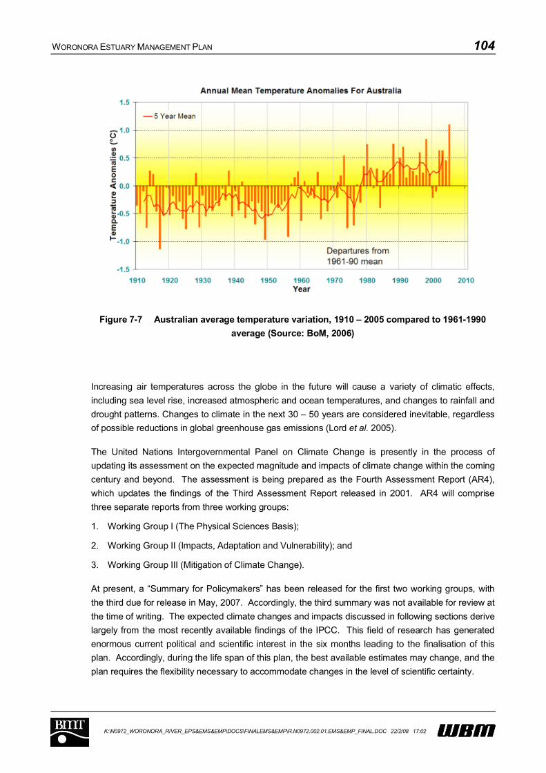
WORONORA ESTUARY MANAGEMENT PLAN 104
K:\N0972_WORONORA_RIVER_EPS&EMS&EMP\DOCS\FINALEMS&EMP\R.N0972.002.01.EMS&EMP_FINAL.DOC 22/2/08 17:02
Figure 7-7 Australian average temperature variation, 1910 – 2005 compared to 1961-1990
average (Source: BoM, 2006)
Increasing air temperatures across the globe in the future will cause a variety of climatic effects,
including sea level rise, increased atmospheric and ocean temperatures, and changes to rainfall and
drought patterns. Changes to climate in the next 30 – 50 years are considered inevitable, regardless
of possible reductions in global greenhouse gas emissions (Lord et al. 2005).
The United Nations Intergovernmental Panel on Climate Change is presently in the process of
updating its assessment on the expected magnitude and impacts of climate change within the coming
century and beyond. The assessment is being prepared as the Fourth Assessment Report (AR4),
which updates the findings of the Third Assessment Report released in 2001. AR4 will comprise
three separate reports from three working groups:
1. Working Group I (The Physical Sciences Basis);
2. Working Group II (Impacts, Adaptation and Vulnerability); and
3. Working Group III (Mitigation of Climate Change).
At present, a “Summary for Policymakers” has been released for the first two working groups, with
the third due for release in May, 2007. Accordingly, the third summary was not available for review at
the time of writing. The expected climate changes and impacts discussed in following sections derive
largely from the most recently available findings of the IPCC. This field of research has generated
enormous current political and scientific interest in the six months leading to the finalisation of this
plan. Accordingly, during the life span of this plan, the best available estimates may change, and the
plan requires the flexibility necessary to accommodate changes in the level of scientific certainty.

WORONORA ESTUARY MANAGEMENT PLAN 105
K:\N0972_WORONORA_RIVER_EPS&EMS&EMP\DOCS\FINALEMS&EMP\R.N0972.002.01.EMS&EMP_FINAL.DOC 22/2/08 17:02
7.4.2 Predicted Changes Associated with the Enhanced Greenhouse Effect
Although there is still uncertainty over the magnitude of changes expected as a result of the
enhanced greenhouse effect, the science has advanced significantly since release of the IPCC’s third
assessment report in 2001. A summary of the expected changes to the climate of South-East
Australia in the future is provided in Table 7-4.
Global atmospheric temperatures are expected to rise (IPCC, 2007A). The best estimates for
average surface air warming range from an increase of 1.8 degrees for a ‘low’ emissions scenario
(range 1.1 to 2.9 degrees), to 4.0 degrees for a ‘high’ emissions scenario (range 2.4 to 6.4 degrees).
Table 7-4 Expected Climatic Changes (IPCC 2007A)
Phenomenon and direction of trend Likelihood of future trend
Warmer and fewer cold days and nights
over most land areas
Virtually Certain
Warmer and more frequent hot days and
nights over most land areas
Virtually Certain
Warm Spells / Head Waves. Frequency
increases over most land areas
Very likely
Heavy precipitation events. Frequency (or
proportion of total rainfall from heavy falls
increases over most areas
Very likely
Area affected by droughts increases Likely
Intense tropical cyclone activity increases Likely
Increased incidence of extreme high sea
level (excludes tsunamis)
Likely
Source IPCC 2007A. Probabilities of occurrence are: Virtually Certain > 99%; Extremely Likely >95%; Very Likely
>90%; Likely > 66%.
Sea level rise is the most accepted of the predictions associated with climate change, however
predictions as to the extent of this rise vary greatly due to the uncertainty of greenhouse gas
concentrations in the future and disagreement on the effect of various levels of such gases (Walsh
2004b). For a ‘low’ emissions scenario a sea level rise of between 0.18 and 0.38 m is expected
during the present century. Similarly, a rise of between 0.26 and 0.59 m is expected, given a ‘high’
emissions scenario (IPCC, 2007A). Changes are expected to be smaller during the first half of the
century (i.e. to 2050) than in the latter half. This variation results from thermal inertia in the oceans
(Walsh et al., 2002) given that ocean surface layers take approximately three decades to absorb heat
from the atmosphere (Flannery, 2005). The subsequent transfer of heat from surface layers to the
deep oceans is likely to take several centuries due to weak diffusion and slow ocean circulation
processes (IPCC, 2001). Thermal expansion of the deep oceans could result in a sea level rise of up
WORONORA ESTUARY MANAGEMENT PLAN 106
K:\N0972_WORONORA_RIVER_EPS&EMS&EMP\DOCS\FINALEMS&EMP\R.N0972.002.01.EMS&EMP_FINAL.DOC 22/2/08 17:02
to 4 metres (occurring over a period of several centuries). When combined with anticipated melting
of polar ice sheets, the predicted ultimate sea level rise is in the order of 7 metres.
Sea level rise in Australia is also likely to be affected by the El Nino Southern Oscillation (ENSO), a
decadal cycle characterised by periods of drought and dryer weather during the El Nino phase of the
cycle, and relatively high rainfall and wetter weather during the La Nina phase. The likely effects of a
warmer climate on the ENSO are not currently well understood.
On-going sea level rise beyond our immediate planning horizon prompts the recommendation for
adoption of conservative sea level rise estimates, as well as the initiation of a program of adaptation
and accommodation of continuously rising seas in the future.
Changes to wave climates and the direction of wave impact are also predicted in association with the
enhanced greenhouse effect. Specifically, east coast low pressure systems, which are currently
responsible for the majority of storm surge water levels and coastal erosion on the NSW coast, may
increase in frequency in the future (Walsh 2004a, Hennessey et al. 2004b). Hennessey et al. (2004b)
suggest that in NSW, waves from the southeast will become more dominant, and waves from the
northeast will become less so.
The intensity of summer storms is forecast to increase by nearly 22% by 2030 (Hennessey et al.
2004b) across NSW. Both Walsh (2004a) and Hennessey et al. (2004b) (in relation to NSW
specifically) comment that, overall, annual rainfall is likely to decrease, but rainfall volume per storm
could potentially increase.
In addition to rainfall changes, higher atmospheric temperatures are likely to increase evaporation
rates (Hennessy et al., 2004a). As a consequence of reduced rainfall and increased evaporation, it is
expected that average streamflow in Australia will decrease (Walsh, 2004a).
A range of studies are currently underway to better appreciate the likely impacts of climate change on
the Australian environment. It is anticipated that as these study findings become available, our
management responses will also change. Therefore, ensuring some flexibility in the provision for
future planning is an essential component of any NRM Plan.
7.4.3 Impacts of Climate Change on Woronora Estuary
Given the above discussion, the Woronora Estuary is expected to be impacted by Climate Change in
the future in the ways outlined in Table 7-5.

WORONORA ESTUARY MANAGEMENT PLAN 107
K:\N0972_WORONORA_RIVER_EPS&EMS&EMP\DOCS\FINALEMS&EMP\R.N0972.002.01.EMS&EMP_FINAL.DOC 22/2/08 17:02
Table 7-5 Climate Change Impacts on the Woronora Estuary
Phenomenon and direction
of trend
Potential (hypothetical) Impacts on the Woronora Estuary
Rise in Sea Levels -Increase in mean water level in Estuary;
-Increase in frequency of inundation of low lying foreshore property
(e.g. Prince Edward Park);
-Increasing depths, offset by increasing tendency toward deposition;
-Displacement of intertidal habitats, including potential loss of
saltmarsh and wader bird habitat.
-Increases in foreshore erosion
Reduced total rainfall with
increasing high intensity event
frequency
-Minor reduction in effectiveness of flushing at upper end of
Woronora Estuary;
-Reduced pollutant loads due to reduced total catchment runoff
-Increase in the frequency of flood events that move, reshape and
modify the plan form of shoals in the Estuary, impacting upon the
reliability of navigation;
-Reduction in ‘attractant’ flows to prompt fish migration between
estuarine and fresh water reaches of the River.
Increase in temperature and
evaporation
-Reduction in availability of water for environmental flows from
Woronora Dam, resulting in a reduction in attractant flows;
-Reduction in effectiveness of flushing at upper end of Woronora
Estuary.
-Increase in pelagic and possibly benthic primary production,
reduced availability of oxygen within water
-Deleterious effects resulting from the solution of salts and therefore
dissolved nutrients, metals and pollutants in the water column;
-Potential changes in distribution and composition of estuarine
vegetation communities
Increase in Coastal Storm
Frequency
-Higher frequency of extreme water levels at the downstream end of
the Woronora;
-Increase in the frequency and magnitude of extreme inundation
events resulting from coastal storms
7.4.4 Planning Considerations for Future Climate Change in the Woronora Estuary
Management of climate change in the future will involve adaptation of systems to new environmental
conditions. Momentum associated with the climate system will result in many more impacts over the

WORONORA ESTUARY MANAGEMENT PLAN 108
K:\N0972_WORONORA_RIVER_EPS&EMS&EMP\DOCS\FINALEMS&EMP\R.N0972.002.01.EMS&EMP_FINAL.DOC 22/2/08 17:02
next several decades (Steffen, 2006). It is considered that the ability of a system to adapt to these
changes and impacts will determine its ability to survive in a future warmer world.
Many environmental systems, such as wetlands, will survive providing that their migration path is not
inhibited and that the rate of migration / species adaptation can keep-up with rate of climate change
(see DEH 2003).
When planning for future development, consideration should be given to conditions at the end of (and
beyond) a realistic planning horizon (say 100 years for residential development). It is important that
protection of property and infrastructure built today will not be reliant upon artificial intervention at
some point in the future. Imposing such conditions on future generations is considered inconsistent
with the principles of Ecologically Sustainable Development (which this Estuary Management Plan is
required to satisfy, in accordance with the central theme of the NSW Coastal Policy). Adequate
vertical and horizontal buffers, capable of accommodating the effects of water level rise should be
adopted.
This Estuary Management Plan has not made specific recommendations with respect to Floodplain
Risk Management, and the need to manage flooding risk in the context of future climate change.
Management of existing development within the vertical and horizontal buffer provisions will need to
be on a site by site basis. Periodic review of this Estuary Management Plan will provide a
mechanism for slowly modifying the management of existing assets and infrastructure in the future.
Over the expected time before the first review of this plan (i.e. 5 years), it is not expected that the
impact of climate change will result in drastic impacts upon the estuary. However, during this time,
the understanding of impacts is likely to improve substantially. It is expected that subsequent reviews
of the plan will need to further consider climate change.
7.5 Protecting Heritage
Implementation activities associated with this plan will consider the protection of both Aboriginal and
European heritage sites in the Estuary and catchment.
The Estuary and its surrounds are rich in both European and Aboriginal heritage. Due to the cultural
significance and sensitivity of a number of places of heritage importance, the locations of these sites
has not been documented within this Plan. SSC has undertaken studies to identify those sites of
interest and presently has policies which identify and guide management of them. These policies
shall be adhered to in the execution of this plan.
Prior to the commencement of any activities that could uncover or damage previously unknown sites
of potential significance, personnel undertaking the works will be provided information that enables
them to identify such sites if they are encountered.
Furthermore, should such sites be uncovered, contact will be made with the NSW Heritage Office or
National Parks and Wildlife Service to determine an appropriate course of action with respect to
management of that site. Any relevant policies or guidelines issued by the Heritage Office or the
National Parks and Wildlife Service shall be adhered to in the management of sites of cultural
heritage significance during the execution of this plan.

WORONORA ESTUARY MANAGEMENT PLAN 109
K:\N0972_WORONORA_RIVER_EPS&EMS&EMP\DOCS\FINALEMS&EMP\R.N0972.002.01.EMS&EMP_FINAL.DOC 22/2/08 17:02
7.6 Monitoring, Evaluation and Amendments
The estuary management program is intended to be iterative, contributing to better management
practice through increasing knowledge, understanding, and awareness of estuary issues, processes
and management alternatives. An important aspect of its implementation will therefore be the periodic
review of effectiveness and progress and subsequent modification of strategies, responsibilities and
funding arrangements.
Ongoing monitoring of the activities that are being undertaken as part of the plan, and reporting on
the outcomes of individual management actions, should be undertaken to ensure proper
implementation and to allow for assessment and evaluation of plan performance.
Community participation and involvement in decision making are integral to the success of the
process. The community should be informed of periodic reviews by using the project database
established during the community consultation phase. This database includes over 180 individuals
that have expressed an ongoing interest in the management of the Woronora Estuary.
While the measures outlined below are important, it is also important to ensure that the focus remains
firmly on achieving the identified management objectives through the implementation of appropriate
actions. If the plan monitoring measures do become cumbersome enough to affect the focus of the
plan, reconsideration of the way in which monitoring is undertaken will be required. Any proposed
changes to the monitoring must ensure that effective, informed decision making and community
involvement are not jeopardised.
7.6.1 Monitoring of Plan Success
The success of the Estuary Management Plan should be gauged through its ability to achieve the
designated targets. The overarching targets are the Management Objectives, as described in
Section 5. However, the timeframe for achieving some of these objectives is long (given the slow
rate of vegetation establishment and growth, for example). To gain a better appreciation for the
relative success of the Plan, a series of evaluation measures can be assessed on a periodic basis.
Different types of evaluation measures are discussed in more detail below.
7.6.1.1 Primary Evaluation Measures
The first set of evaluation measures should ascertain whether the strategies are being implemented
within the timeframe designated in the Plan. As such, the primary performance measures are simply
a measure of implementation.
The Estuary Management Plan recommends some 22 different strategies over a period of 5 years.
Many of these strategies will need to be carried out concurrently. Organisations responsible for
implementation will need to review the Plan carefully and ensure that adequate resources are
allocated to the various strategies to ensure that the timeframe for implementation is achieved.
Clearly, a high degree of co-ordination will be required to manage the successful implementation of
all the strategies within the designated timeframe. This co-ordination should be facilitated by the
Woronora Estuary Management Committee, who would be required to meet regularly to discuss and
manage the implementation of the estuary management strategies.

WORONORA ESTUARY MANAGEMENT PLAN 110
K:\N0972_WORONORA_RIVER_EPS&EMS&EMP\DOCS\FINALEMS&EMP\R.N0972.002.01.EMS&EMP_FINAL.DOC 22/2/08 17:02
If it is determined that the strategies are not being implemented to the nominated timeframe then one
or both of the following contingencies should be adopted:
Determine the cause for the delay in implementation. If delays are funding based, then seek
alternative sources of funding, including a formal request to Council to increase contributions to
the Plan. If delays are resource-based, seek additional assistance from stakeholder agencies
and/or consider using an external consultancy to coordinate implementation of the Plan;
Modify and update the Estuary Management Plan to reflect a timeframe for implementation that
is more achievable. The revised Plan would need to be endorsed by all relevant stakeholders
and agencies responsible for implementation.
7.6.1.2 Secondary Evaluation Measures
The second set of evaluation measures relate to measuring specific performance outputs from the
individual strategies, as appropriate. The specific outputs from each strategy, are provided within the
Implementation Schedules (refer Section 7.2) under ‘Performance measure’. These measures
define what the specific outcome from each strategy should be. If these outputs are delivered as
defined, then the strategy is considered to have been successful.
If the defined performance measures are not generated as a result of implementation of the strategy
then the following contingencies need to be adopted:
Determine the reason for not producing the specified output. If the reason involves a lack of
funding or resources, then similar contingency measures to those described for the primary
performance measures (refer Section 7.6.1.1) should be adopted. If the reason is of a technical
nature, then expertise in the area should be consulted to overcome the technical problem.
DECC and other government agencies should have the necessary in-house expertise to assist in
most cases.
Review the appropriateness of the specific output of the management strategy, and if necessary,
modify the output described in the Plan to define a more achievable product.
7.6.1.3 Tertiary Evaluation Measures
The third set of evaluation measures are aimed at measuring the outcomes of the Plan, and as such
relate to the specific management objectives of the Plan (as described in Section 5), and how
implementation of the Plan has made a difference to the biophysical and social environments of the
Woronora Estuary (e.g. reduction in pollutant loads, improvement in swimming conditions, increase in
biodiversity etc). The main mechanism for gauging whether these objectives have been achieved, or
not, is monitoring. Therefore, monitoring of various elements of the physical, biological and social
environment is an essential component of assessing the overall success of the Estuary Management
Plan.
If, after a reasonable period of time, the specific objectives of the Plan are not being achieved by the
strategies being implemented, then the following contingencies should be adopted:
Carry out a formal review of the implemented management strategies, identifying possible
avenues for increasing the effectiveness of the strategy in meeting the Plan objectives;
WORONORA ESTUARY MANAGEMENT PLAN 111
K:\N0972_WORONORA_RIVER_EPS&EMS&EMP\DOCS\FINALEMS&EMP\R.N0972.002.01.EMS&EMP_FINAL.DOC 22/2/08 17:02
Commence implementation of additional management strategies that may assist in meeting Plan
objectives (possibly ‘fast-track’ some longer term strategies as necessary);
Reconsider the objectives of the Plan to determine if they set impossible targets for future
estuary conditions, and adjust the Plan, as necessary. Any such changes to the Plan would
need to be endorsed by the stakeholders and relevant government agencies, as well as the
public.
7.6.1.4 Reviews and Amendments
Periodic reviews and amendments of this Estuary Management Plan are necessary to ensure that it
remains current and relevant to the environmental management and planning framework in which it
operates. Future reviews of the Plan should consider:
Is the level of community support and involvement being maintained?
Are Council and government agencies still supportive and involved in the implementation?
Are the objectives still relevant, or have conditions, circumstances, priorities and the level of
understanding changed?
Are the indicators selected to assess performance of a given strategy and monitoring parameters
the most appropriate?
It is proposed that the Woronora River Estuary Management Plan is reviewed on a regular basis, and
completely updated within a period of about 5 years (i.e. before end 2012). A regular review of the
Plan (which may occur annually, for example) is necessary to allow modifications / alterations to the
management of the estuary, on an as-needed basis, within the context of an adaptive management
framework.
Any modification to the Plan will need to be exhibited to the community and referred to Council for
adoption.
The periodic Estuary Management Plan reviews should cover the topics described in Table 7-6. This
table also outlines who is responsible for conducting the periodic reviews.
It is possible that the NSW Government’s Estuary Management Program, under which this Plan has
been prepared and will be implemented, may change in the future. A new Coastal Zone
Management Manual is currently in preparation, and will combine and replace the existing Estuary
Management Manual (1992) and the Coastline Management Manual (1990). Therefore, on-going
liaison between Council, DECC and the Estuary Management Committee is necessary to ensure that
the aims and objectives of the Woronora River Estuary Management Plan continue to be achieved in
the future.
Table 7-6 Framework for Future Estuary Management Plan Review
Review Period Review tasks Responsibility
Annual Assess primary, secondary and tertiary evaluation measures, and determine appropriate contingencies if
Estuary Management Committee or appointed
WORONORA ESTUARY MANAGEMENT PLAN 112
K:\N0972_WORONORA_RIVER_EPS&EMS&EMP\DOCS\FINALEMS&EMP\R.N0972.002.01.EMS&EMP_FINAL.DOC 22/2/08 17:02
performance measures do not meet targets
Review funding arrangements and allocations for current and future management strategies
Review resourcing and staffing allocations for current and future management strategies
Provide report on progress of Estuary Management Plan implementation, results of annual review, and any modifications required to the Plan coming out of the review
external consultant*
To be coordinated through Council and reported to
Council, relevant stakeholders and government
agencies
5 Yearly
(first review to be completedby end 2012)
Assess the overall effectiveness of each management strategy implemented to date
For strategies requiring on-going commitment, assess the value in maintaining implementation of those strategies
Reconsider the management options that were not short-listed and included in the original Plan
Provide implementation details of additional strategies that are to be included in the subsequent 5 year Plan
Update the Estuary Management Plan document to reflect proposed strategies for implementation over the next 5 year period, and seek endorsement by stakeholders, government agencies and the community.
Estuary Management Committee or appointed
external consultant*
To be coordinated through Council and reported to
Council, relevant stakeholders government agencies and the general
community
* It would be advantageous for the same consultant responsible for initially preparing the Estuary
Management Plan to be involved in the annual review and 5-yearly update, given their appreciation of
the study area and the details of the Plan and associated strategies.
7.6.2 Amendment Record
This Plan was last reviewed and amended on ………………………………………………..
The next scheduled review is due ………………………………………………………………

REFERENCES 113
K:\N0972_WORONORA_RIVER_EPS&EMS&EMP\DOCS\FINALEMS&EMP\R.N0972.002.01.EMS&EMP_FINAL.DOC 22/2/08 17:02
8 REFERENCES
ACER (1995), Woronora River Floodplain Management Study, September, 1995.
Australian and New Zealand Environment Conservation Council [ANZECC] (2000), Australian
Guidelines for Fresh and Marine Water Quality 2000. Australian and New Zealand Environment
Conservation Council, Australia.
AWT (2000) Woronora River Stormwater Management Plan, Australian Water Technologies,
September 2000.
Bell, J. D. and Pollard, D. A. (1989) Ecology of fish assemblages and fisheries associated with
seagrasses. In: A. W. D. Larkum, A. J. McComb and S. A. Shepherd, Biology of Seagrasses: A
treatise on the biology of seagrasses with special reference to the Australian region, (pp 565-609).
Elsevier, Amsterdam.
Bureau of Meteorology (BoM) (2006) “Annual Australian Climate Summary 2005”, [online]. Available
from http://www.bom.gov.au/announcements/media_releases/climate/change/20060104.shtml
[accessed 11 January 2006]. Bureau of Meteorology, Australian Government.
Bruce, A., Growns, I. and Gehrke, P. (2001) Woronora River Macquarie Perch Survey. Final Report
to Sydney Catchment Authority, April 2001. 116pp.
Bureau of Meteorology (2006) Climate Averages viewed downloaded from the internet site at
Burgess (1994) Nature's Doorstep The Bonnet Bay Story, Colin Burgess.
Clarke, S.M. and Kirkman, H. (1989). Seagrass Dynamics. In: Biology of Seagrasses: A Treatise on
the Biology of Seagrasses with Special Reference to the Australian Region. By Larkum, A.W.D,
McComb, A.J., and Shepherd, S.A. (1989). Elsevier, Amsterdam.
Como Residents (1981) Impact of Development of the Foreshore at Como, May 1981.
Connell Wagner Pty Ltd (2001) Bangor Bypass: Environmental Impact Statement Summary,
February 2001.
CSIRO 2004 Climate Changes in NSW Part 2: Projected changes in Climate Extremes
Dames and Moore (1997a) Woronora River Baseline Studies, Prepared for Sydney Water
Corporation, November 1997.
Dames and Moore (1997b) Woronora River Reference Stream Pilot Study, Prepared for Sydney
Water Corporation, November 1997.
Department of Environment and Heritage. www.deh.gov.au. Accessed November 2005.
Douglas P (1984) Channel Change in a Tidal System: Woronora River, School of GeoScience,
University of Sydney.

REFERENCES 114
K:\N0972_WORONORA_RIVER_EPS&EMS&EMP\DOCS\FINALEMS&EMP\R.N0972.002.01.EMS&EMP_FINAL.DOC 22/2/08 17:02
Douglas, P.A (1984) “Channel Changes in a Tidal System: Woronora River, NSW” Dissertation for
Bachelor of Economics (Hons) degree, University of Sydney.
DUAP (1998) Georges River Catchment: Regional Environmental Study, Department of Urban Affairs
and Planning.
Edgar, G.J. (2001) Australian Marine Habitats in Temperate Waters, Reed New Holland Publishers
(Australia), Sydney
Edwards, D, Brown, M & Drinnan, I (unpublished) “The effects of a hazard reduction burn on runoff
and sediment yield, Sutherland, NSW.”
Ellison, JC (1993). Mangrove retreat with rising sea-level, Bermuda. Estuarine Coastal and. Shelf
Science, 37, 75-87.
EPA (1999) “Environmental Guidelines: Assessment, Classification and Manaagement of Liquid and
Non-Liquid Wastes”
Eveden D (1992) Distribution of Heavy Metal in Sediment of the Georges River, School of
GeoScience, University of Sydney.
Ferguson, Christobel, M., Coote, Brian, G., Ashbolt, Nicholas, J. and Stevenson, Iain, M. 1996
Relationships between indicators, Pathogens and water Quality in an estuarine system in Wat. Res.
Vol 30, No. 9, pp2045-2054
Flannery, T. (2005) “The weather makers: The history and future impact of climate change”, Text
publishing, Melbourne
Foreman, M.G.G (1977) “Manual for Tidal Heights Analysis and Prediction” Institute of Ocean
Sciences, Patricia Bay Victoria, B.C.
Heeemstra S (1994) Classification and Assessment of Vegetated Land of Western Sutherland Shire,
School of Geography, University of New South Wales, July 1994.
Henderson P.D (1981), An Environmental Review of the Woronora Valley, August 1981.
Hennessy, K., Page, C., McKinnes, K., Jones, R., Bathols, J., Collins, D., Jones, D. (2004a) “Climate
change in New South Wales: Part 1 – Past climate variability and projected changes in average
climate” CSIRO consultancy report for the NSW Greenhouse Office, Aspendale, Victoria, July
Hennessy, K., McKinnes, K., Abbs, D., Jones, R., Bathols, J., Suppiah, R., Ricketts, J., Rafter, T.,
Collins, D., Jones, D. (2004b) “Climate change in New South Wales: Part 2 – Projected changes in
climate extremes” CSIRO consultancy report for the NSW Greenhouse Office, Aspendale, Victoria,
November
HNRMC (2003) “The Current Environmental Flow Regime Downstream of Woronora Dam – Possible
Alignment of Flow Specifications (and Monitoring) with the Forum’s Recommendations for the
Hawkesbury-Nepean and Shoalhaven River Systems” Prepared by Independent Expert Panel on
Environmental Flows for the Hawkesbury-Nepean, Shoalhaven and Woronora Catchments.
Hawkesbury-Nepean River Management Forum, August.
REFERENCES 115
K:\N0972_WORONORA_RIVER_EPS&EMS&EMP\DOCS\FINALEMS&EMP\R.N0972.002.01.EMS&EMP_FINAL.DOC 22/2/08 17:02
Hoffmann et al (2000) Environmental and Effluent Monitoring at ANSTO Sites 1999, EL Hoffmann, T
Loosz, L Mokhber-Shahin.
Hoffmann et al (2001) Environmental and Effluent Monitoring at ANSTO Sites 2000, EL Hoffmann, T
Loosz, L Mokhber-Shahin.
Hoffmann et al (2002) Environmental and Effluent Monitoring at ANSTO Sites 2001, EL Hoffmann, T
Loosz, L Mokhber-Shahin.
Hoffmann et al (2003) Environmental and Effluent Monitoring at ANSTO Sites 2002 – 2003, EL
Hoffmann, JM Ferris & SJ Markich.
HRC (1999) “Independent Inquiry into the Woronora River System: Expert Panel Report” prepared by
the Healthy Rivers Commission of New South Wales , June
HRC (1999) DRAFT Independent Inquiry into the Woronora River System, Healthy Rivers
Commission, June 1999.
HRC (2001) Independent Inquiry into the Georges River - Botany Bay System, Healthy Rivers
Commission, September 2001.
IPCC (2001) “Climate change 2001: The Scientific Basis” Intergovernmental Panel on Climate
Change, Cambridge University Press, Cambridge
IPCC (2007A) “Climate Change 2007: The Physical Science Basis: Summary for Policymakers”
IPCC (2007B) “Climate Change 2007: Climate Change Impacts, Adaptation and Vulnerability:
Summary for Policymakers”
Kailola, P. J., Williams, M. J., Stewart, P. C., Reichelt, R. E., McNee, A. and Grieve, C. (1993)
Australian Fisheries Resources. Bureau of Resource Sciences, Department of Primary Industries and
Energy, and the Fisheries Research and Developement Corporation, Canberra. 422 pp.
Keyzer N (2001) “The Physiochemistry of the Surface Water of the Woronora River System“ Masters
of Environmental Science (Hons.) Research Report. Environmental Science Program, Faculty of
Science, University of Wollongong , December
Kuiter, R. (1993) Coastal Fishes of South Eastern Australia. Crawford House Publishers., Bathurst.
437 pp.
Lee Long, W. J., Mellors, J. E. and Coles, R. G. (1993) Seagrasses Between Cape York and Hervey
Bay, Queensland, Australia. Aust. J. Mar. Freshwater Res., 44: 19-31.
Loftus Bushcare Coalition (2000) Final Project Report (Riparian Restoration of sub-catchment of
Loftus Creek), July 2000.
Lord, D., Gibbs, J., McLuckie, D. (2005) “A year after the day after tomorrow – the application of
climate change to coastal zone management in NSW” Proc. 14th ann. NSW coast. conf., Narooma, 8
– 11 Nov. 2005
REFERENCES 116
K:\N0972_WORONORA_RIVER_EPS&EMS&EMP\DOCS\FINALEMS&EMP\R.N0972.002.01.EMS&EMP_FINAL.DOC 22/2/08 17:02
McKenzie, L. J., Roder, C. A., Roelofs, A. J. and Lee Long, W. J. (2000) Post-flood monitoring of
seagrasses in Hervey Bay and the Great Sandy Strait, 1999: Implications for dugong, turtle and
fisheries management. Marine Plant Ecology Group, Information Series: QI00059. Cairns. 2000.
MHL (1999) Woronora River: Assessment of Estuarine Processes, Manly Hydraulics Laboratory
MHL (2003) “DLWC NSW Tidal Planes Data Compilation 2001: Volume 1 Tidal Plane Analyses”
Report MHL 1098 March.
Midgley (1970) "A Ride into History" Story of - Loftus, Woronora, Engadine, A & F Midgley.
Naylor, S.D., Chapman, G.A., Atkinson, G., Murphy, C.L., Tulau, M.J., Flewin, T. C., Milford, H.B.,
Morand, D.T., (1998) Guidelines for the Use of Acid Sulfate Soil Risk Maps, 2nd ed., Department of
Land and Water Conservation, Sydney.
New South Wales National Parks and Wildlife Service (2003). Native Vegetation Of The Woronora,
O’Hares And Metropolitan Catchments. Conservation Assessment And Data Unit Central
Conservation Programs And Planning Division. Undertaken for the Sydney Catchment Authority.
New South Wales National Parks and Wildlife Service (2003). Native Vegetation Of The Woronora,
O’Hares And Metropolitan Catchments. Conservation Assessment And Data Unit Central
Conservation Programs And Planning Division. Undertaken for the Sydney Catchment Authority.
New South Wales National Parks and Wildlife Service. (1999). Classification of vegetation
disturbance for the Georges River Catchment.
New South Wales National Parks and Wildlife Service. (1999). Classification of vegetation
disturbance for the Georges River Catchment.
New South Wales National Parks and Wildlife Service. (2005). www.
http://www.nationalparks.nsw.gov.au. Accessed November 2005.
NPA (1992) A Vision for the Future of the Remaining Natural Lands of Menai and Woronora, National
Parks Association of NSW Inc, October 1992.
NPWS (2000) Royal National Park, Heathcote National Park and Garawarra State Recreation Area
Plan of Management, National Parks and Wildlife Services, February 2000.
NSW Department of Environment and Conservation.
www.threatenedspecies.environment.nsw.gov.au. Accessed November 2005.
Patterson Britton & Partners Pty Ltd (2002) Redevelopment of Prince Edward Park Wharf, Woronora
July 2002.
Pickthall, J., Williams, R.J., Adams, P. and Connolly, D. in: Williams, R.J., Bryant, A., and Ledlin, D.
(Eds) (2004) Biodiversity of the Georges River Catchment: Aquatic Biodiversity. Department of
Infrastructure, Planning and Natural Resources: Sydney.
Pulling KE. (2001) The Woronora River 2001: Diatoms and Water Chemistry
REFERENCES 117
K:\N0972_WORONORA_RIVER_EPS&EMS&EMP\DOCS\FINALEMS&EMP\R.N0972.002.01.EMS&EMP_FINAL.DOC 22/2/08 17:02
Pulling, K.E. (2001) “The Woronora River 2001: Diatoms and Water Chemistry” Bachelor of
Environmental Science Honours Degree research report. Environmental Science Program, Faculty
of Science, University of Wollongong.
PWD (1991b) Woronora River Flood Study, Public Works Department, August 1991.
PWD (1991c) “Georges River Tidal Gauging and Current Metering, August 1991” Manly Hydraulics
Laboratory Report MHL 611, November.
PWD(1991a) Woronora River Flood Study, Compendium of Data, Public Works Department, August
1991.
Remane, A. C. and Schlieper, C. (1971) Biology of Brackish Water. Wiley, New York. 271 pp.
Roy, P. S., Williams, R. J., Jones, A. R., Yassini, I., Gibbs, P. J., Coates, B., West, R. J., Scanes, P.
R., Hudson, J. P. and Nichol, S. (2001) “Structure and function of Southeast Australian Estuaries”
Estuarine, Coastal and Shelf Science 53:351-384
RTA (1990a) New Bridges and Approaches at the Woronora River, Woronora – Environmental
Impact Statement, Roads and Traffic Authority, November 1990.
RTA (1990b) New Bridges and Approaches at the Woronora River, Woronora - Consultant Reports,
Roads and Traffic Authority.
Saenger, P., Moverley, J. and Stephenson, W. (1988) Seasonal and longer term patterns in the
macrobenthos versus benthic stability in a subtropical estuary. Proceedings of the Ecological Soiciety
of Australia, 15: 229-237.
Saenger, P., Specht, M. M., Specht, R. L. and Chapman, V. J. (1977) Mangal and Coastal Saltmarsh
Communities in Australia. In: V. J. Chapman, Wet Coastal Ecosystems, (pp Elsevier Scientific
Publishing Company Amsterdam,
Saintilan, N. (2004) Relationships between estuarine geomorphology, wetland extent and fish
landings in New South Wales estuaries. Estuarine, Coastal and Shelf Science, 61: 591-601.
Saintilan, N. and Williams, R. J. (1999) Mangrove trangression into saltmarsh environments in south-
east Australia. Global Ecology and Biogeography, 8: 117-124.
Saintilan, N. and Williams, R. J. (2000) Short Note: The Decline of Saltmarsh in Southeast Australia:
Results of Recent Surveys. Wetlands (Australia), 18: 49-54.
SCA (1999) Special Areas Background Document, Sydney Catchment Authority and National Parks
and Wildlife Service.
SCA (2000) Annual Water Quality Monitoring Report 1999 – 2000, Sydney Catchment Authority,
November 2000
SCA (2001a) Special Areas Strategic Plan of Management, Sydney Catchment Authority and
National Parks and Wildlife Service, March 2001.

REFERENCES 118
K:\N0972_WORONORA_RIVER_EPS&EMS&EMP\DOCS\FINALEMS&EMP\R.N0972.002.01.EMS&EMP_FINAL.DOC 22/2/08 17:02
SCA (2001b) Annual Water Quality Monitoring Report 2000 - 2001, Sydney Catchment Authority.
SCA (2002a) Dams of Greater Sydney and Surrounds Woronora, Sydney Catchment Authority,
November 2002.
SCA (2002b) Water Quality Monitoring Report Part 1: Summary 2001 - 2002, Sydney Catchment
Authority.
Soil Conservation Service of NSw (1990) “Wollongong – Port Hacking” Soil Landscape Series Sheet
9029 -9129
SPCC (1979) “Soil Erosion Potential in the Menai Area” State Pollution Control Commission,
Environmental Control Study of Botany Bay
SPCC (1980) Environmental Control Study of Botany Bay Summary Report – for Discussion and
Comment State Pollution Control Commission, December 1980.
SSC (1997) Sutherland Shire Council Draft Woronora Valley Master Plan, October 1997.
SSC (1998) State of the Environment Report 1998, Sutherland Shire City Council.
SSC (1999) State of the Environment Report 1998/99, Sutherland Shire City Council.
SSC (2000a) State of the Environment Report 1999/2000, Sutherland Shire City Council.
SSC (2000b) Sutherland Shire Council Sutherland Shire Local Environmental Plan 2000
SSC (2001) State of the Environment Report 2000/01, Sutherland Shire City Council
SSC (2002), Greenweb Protection and Enhancing our Natural Environment, Sutherland Shire
Council, Brochure, August 2002.
SSC (2003) Sutherland Shire Council Sutherland Shire Draft Local Environmental Plan 2003.
SSC (2004) State of the Environment Report 2003/04, Sutherland Shire City Council.
SSC (2005) State of the Environment Report
SSC (2006) Sutherland Shire Local Environment Plan 2006
SSEC (1995) Exploring the Woronora, Video, Sutherland Shire Environment Centre.
SSEC (2003) The Great Kai'mia Way, Decemberr 2003.
SSROC (2004), Green Web Sydney: About Green Web, Southern Sydney Regional Council, Online
16th January 2004, http://www.greenwebsydney.net.au/aboutgreenweb/index.cfm.
Standards Australia (1999) Risk Management AS/NZS 4360, April 1999.
Storey C (1989) Investigation of the Water Quality of Forbes Creek, Engadine, Colin Storey, February
1989, Facility of Applied Science, University of New South Wales.
REFERENCES 119
K:\N0972_WORONORA_RIVER_EPS&EMS&EMP\DOCS\FINALEMS&EMP\R.N0972.002.01.EMS&EMP_FINAL.DOC 22/2/08 17:02
Sutherland Shire Bushcare Group (2001a) The Glen and Koolangarra Bushland Bush Walk Guide,
July 2001.
Sutherland Shire Bushcare Group (2001b) Jannali Reserve Bush Walk Guide, July 2001.
Sutherland Shire Council (2003) Fact Sheet Number 6 Sutherland Shire Place Names
Sutherland Shire Council (2004). State of the Environment Report 2003/2004.
Sydney Water (2001) Sydney Water Environmental Indicators Compliance Report: Sydney Water
Annual Report.
Sydney Water (2002) Sydney Water Environmental Indicators Compliance Report: Sydney Water
Annual Report 2002
Sydney Water (2003) Sydney Water Environmental Indicators Compliance Report: Sydney Water
Annual Report.
Thackway R, Creswell ID. (1995) An interim biogeographic regionalisation for Australia: a framework
for setting priorities in the National Reserves System Cooperative Program. Version 4.0. ANCA,
Canberra.
Thackway, R. and Cresswell, I.D. (Eds) 1995. An Interim Biogeographic Regionalisation for Australia:
A framework for setting priorities in the national reserves system cooperative program, Version 4.0.
Australian Nature Conservation Agency, Canberra.
Valentine, Laurie & Davies Pty. Ltd. (1984) Woronora Heights Access Environmental Study, October
1984.
Walsh, K. (2004a) “Climate change and coastal response: a theme report from the Coast to Coast
2002 National Conference, Gold Coast, November 2002” CRC for Coastal Zone, Estuary and
Waterway Management, Indooroopilly, April 2004
Walsh, K. (2004b) “Climate change and the coast: Science and adaptation” Proc. Coast to Coast
2004, Aust. nat. coastal conf., Hobart, 19-23 April
Warner, R.F and Pikup, G. (1978) “Channel Changes in the Georges River between 1969 and
1973/76 and their Implications” report published by Bankstown Municipal Council.
Warner, R.F and Pikup, G. (1978) “Channel Changes in the Georges River between 1969 and
1973/76 and their Implications” report published by Bankstown Municipal Council.
WBM Oceanics Australia (2004) “Woronora River Data Compilation Study” prepared for Sutherland
Shire Council, June.
WBM Oceanics Australia (2007) “Woronora River Estuary Processes Study” prepared for Sutherland
Shire Council.
West, R.J., Thorogood, C., Walford, T., & Williams, R.J., 1985. Fisheries Bulletin 2: An estuarine
inventory for NSW, Australia. Department of Agriculture – division of Fisheries, New South Wales.
REFERENCES 120
K:\N0972_WORONORA_RIVER_EPS&EMS&EMP\DOCS\FINALEMS&EMP\R.N0972.002.01.EMS&EMP_FINAL.DOC 22/2/08 17:02
Williams, D.G and Roberts, R. (2005). Riparian Vegetation Diversity In The Sydney Catchment
Authority’s Area Of Operation. Cooperative Research Centre For Freshwater Ecology. Prepared
For The Sydney Catchment Authority.
Williams, R.J. and Louden, B. in: Williams, R.J., Bryant, A., and Ledlin, D. (Eds) (2004) Biodiversity of
the Georges River Catchment: Aquatic Biodiversity. Department of Infrastructure, Planning and
Natural Resources: Sydney
Wilton, K. M. and Scintilan, N. (2000) Protocols for mangrove and saltmarsh habitat mapping.
Woronora Public School (Unknown) Woronora Ripples, Children and Teachers of Woronora Public
School.
WSN (2005) WSN Environmental Solutions Annual Report 2004-2005 WSN Environmental
Solutions.

RESULTS OF MULTI CRITERIA ASSESSMENT A-1
K:\N0972_WORONORA_RIVER_EPS&EMS&EMP\DOCS\FINALEMS&EMP\R.N0972.002.01.EMS&EMP_FINAL.DOC 22/2/08 17:02
APPENDIX A: RESULTS OF MULTI CRITERIA ASSESSMENT
The spreadsheet that has been used to assess the various management options considered as part
of this study is reproduced on the following page. The following describes the way in which the final
score for each management option has been derived.
The different management options are listed in the “Strategies” column. Immediately to the right of
the Strategies column are 19 columns representing management objectives 1 through to 19, as
summarised in Table 5-1. The second row at the top of each of these objective columns contains a
“Relative Score”. The relative score is equal to the score that has been used to obtain the priority
ranking of management objectives as summarised in Table 5-1.
Each management option has been assessed against each management objective with
“Effectiveness Scores” assigned as follows:
Column Blank: Management Option does not appreciably address this objective
Score = 0.5 : Management option addresses this objective, but only in a secondary manner (i.e.
there is a weak interaction);
Score = 1.0 : Management option is expected to address this objective significantly; and
Score = 1.5: Management option is expected to address this objective extremely well.
The effectiveness score has been assigned on the basis of experience in both other locations and in
the Woronora Area, feedback obtained from community consultation, findings from the Estuary
Processes Study and an overall understanding of the functioning of the Estuary and the community
that lives within its catchment. While these scores are well informed, there is definitely a degree of
subjectivity that could be queried. However, the resulting short listed of management options have
been assessed as reasonable.
A cumulative total representing the ability of each option to address the objectives has been
determined by calculating the total of these scores multiplied by the relative score of each
management objective with which it interacts. Mathematically, this could be represented as
OPTOBJ ESRSTotal 19
1
Where RSOBJ is the relative score of the objective, ESOBJ is the effectiveness score representing the
interaction of the objective and option being considered.
The total is subsequently multiplied by a cost factor (Low Cost = 3, Medium Cost = 2, High Cost = 1-
see the cost factor and cost columns) and a community acceptance/effectiveness factor (High = 3,
Moderate = 2, Low = 1 – see the effectiveness/acceptance and effect factor columns). The resulting
Score has been multiplied by ten and rounded to give a whole number and then ranked on the basis
of that number.

RESULTS OF MULTI CRITERIA ASSESSMENT A-2
K:\N0972_WORONORA_RIVER_EPS&EMS&EMP\DOCS\FINALEMS&EMP\R.N0972.002.01.EMS&EMP_FINAL.DOC 22/2/08 17:02
Objectives 1 2 3 4 5 6 7 8 9 10 11 12 13 14 15 16 17 18 19 Score * 10Relative Score 0.42 0.30 0.37 0.34 0.23 0.26 0.30 0.19 0.20 0.32 0.31 0.29 0.22 0.16 0.35 0.17 0.16 0.18 0.22 COST Obj*costfact EFFECT (Rounded)
Strategies FACTOR FACTOR
WQ-1Planning ST
Emergency Plan for Illegal Dumping. This would include the provision of appropriate clean up infrastructure at various locations along the River. 1 0.5 0.3297101 L 3 0.989130286 H 3 2.97 30 16
WQ-2On-ground Works MT
End of Pipe Treatment for Stormwater Outlets. Suggestions include provision of 'meshes' or 'grates' at outlet locations. This would primarily be to trap rubbish 1 0.4222602 H 1 0.422260207 H 3 1.27 13 34
WQ-3
Planning MT
Restrict Waterfront and Ridge Top Development. The restriction of these types of development would prevent the exacerbation of any sediment (silt/sand) coming off the catchment, which is seen by many as the source of siltation of the River. 1 0.5 0.5944955 M 2 1.188991038 M 2 2.38 24 27
WQ-4
On-ground Works MT
Source Control in Catchment Stormwater (slowing runoff). This would involve the retrofitting of existing stormwater infrastructure with appropriate GPT, sediment traps to protect the river at source and controlling runoff speed. 1.5 1.5 1.1500962 H 1 1.150096246 H 3 3.45 35 11
WQ-5 Monitoring ST Locate and monitor all OSS systems 1 0.2957645 L 3 0.887293531 M 2 1.77 18 31WQ-6 Education ST Education Program (unsealed surfaces etc. etc.) 1 0.4222602 L 3 1.266780622 M 2 2.53 25 24WQ-7 Administration ST More effective policing and penalties for people caught dumping into the River. 1 0.2295385 L 3 0.68861539 L 1 0.69 7 41WQ-8 On-ground Works LT Assess and upgrade Sewerage System to minimise overflows 1 1.5 0.9709654 H 1 0.970965374 H 3 2.91 29 19WQ-9 Planning and Controls MT Prepare Council Policy for Best Practice Management of Stormwater - i.e. WSUD 1 1 0.7667308 L 3 2.300192492 M 2 4.60 46 6WQ-10
Planning and Controls STDon't open the fire trail. This is a proactive measure to prevent the additional runoff from the road, introducing pollutants and sediment into the river. 1 0.4222602 L 3 1.266780622 L 1 1.27 13 34
Ecol-1 On-ground Works Imm Fish Passage: Construction of an effective fish passage at the pass of Sabugal. This area is a priority barrier to fish Migration for DPI, and is being addressed at present, although the barrier is not being completely removed 1 0.1880766 L 3 0.564229763 H 3 1.69 17 33
Ecol-2 On-ground Works Imm Bushcare Groups: Revegetate areas close to and within ecologically sensitive areas1 1 0.6206531 L 3 1.861959311 H 3 5.59 56 4
Ecol-3 Administration ST Contact appropriate task force re. the subject of environmental flows and provide input to that process 1 1 0.4511056 L 3 1.35331669 M 2 2.71 27 23
Ecol-4 On-ground Works ST Targeted Bush Regeneration at Shackels Estate. There is a proliferation of terrestrial weeds upon properties "bought back". A problem may be the presence of Asbestos.
1 0.3166871 L 3 0.950061241 H 3 2.85 29 20Ecol-5 Education ST Mark key habitat areas on boating charts and at recreational access points to the estuary
1 1 0.5043093 L 3 1.512927864 H 3 4.54 45 7Ecol-6 On-ground Works ST Bushcare groups used to revegetate a riparian buffer zone for the protection of aquatic
ecosystems. 1 1 1 0.9314351 L 3 2.794305303 M 2 5.59 56 3Ecol-7 Investigation and Review Imm Mapping Study of saltmarsh and seagrass, overlaid with threats (e.g. stormwater etc.) or
erosion 1 1 0.5043093 L 3 1.512927864 H 3 4.54 45 7Ecol-8 Planning and Controls MT In planning, include upstream buffer zones to allow upward migration of salt marsh with
sea level rise. 1 1 0.5043093 L 3 1.512927864 M 2 3.03 30 15Ecol-9 Planning and Controls MT Foreshore structures designed to minimise impact on aquatic vegetation 1 0.303966 L 3 0.911898071 L 1 0.91 9 39Ecol-10 Planning and Controls ST Additional Promotion of Green Web Program to protect the important ecological corridor
in the Forbes/Loftus Creeks areas 1 0.303966 L 3 0.911898071 M 2 1.82 18 29Ecol-11 Education MT Community Education Program on Ecology and Heritage 1 1 0.4687252 L 3 1.406175583 M 2 2.812351166 28 21
W&F-1 Education Imm Replace and/or Improve Speed Limit Signage. The aim of this is to ensure that everyone actually knows what the waterway speed limits are, as boat wake is almost definitely the main cause of foreshore erosion 1 1 0.487392 M 2 0.974784005 H 3 2.92 29 17
W&F-2 On-ground works ST Moderate, targeted and ongoing dredging with regular monitoring with appropriate safeguards. This is the most commonly recommended strategy from community respondents. The need for dredging has been earmarked at numerous locations along the entire river. Suggestions include, near Bonnet Bay, Forbes Creek, areas upstream of Deepwater (for fire access) and the entrance shoals 1 1 0.5363898 M 2 1.072779614 H 3 3.22 32 13
W&F-3 On-ground works LT Extensive Dredging. One community respondent has made particular reference to the loss of seawalls following extensive dredging and this would need to be considered, along with the loss of seagrass. Some consider that major sedimentation has resulted from activities during construction of the Bridge. 1 0.3519531 H 1 0.351953114 L 1 0.35 4 43
W&F-4 Education Imm Education of Boaters on Speeding and the damage it does. This could include appropriate signage at points of access to the river. Leaflets at various commercial establishments. 1 1 0.5 0.59653 L 3 1.789589973 H 3 5.37 54 5
W&F-5 Planning and Controls Imm Limit Speed Limit to 4 knots in River or review speed limits in vicinity of eroding foreshores (also no-wake zones) 1 1 0.5 0.59653 L 3 1.789589973 M 2 3.58 36 9
W&F-6 Planning and Controls ST Prevent Large Boats. Large boats are implicated in causing boat wake erosion. Of particular note is Council's waste barge. This needs to be resolved.
1 0.2870487 L 3 0.861146214 M 2 1.72 17 32W&F-7 Administration Imm More frequent and effective policing of waterway users 1 1 1 0.7169305 L 3 2.150791397 H 3 6.45 65 1W&F-8 On-ground works MT Soft Protection of eroding foreshores. This may be appropriate in more natural areas
such as fronting the scout camp etc, areas fronting Mangroves etc. 1 1 0.614748 H 1 0.614748021 M 2 1.23 12 37W&F-9 On-ground works ST Hard Protection/Repair of Eroding Foreshores. Areas where this needs to be targeted
include Janalli Reserve (Burnum Burnum Sanctuary) Prince Edward Park (do we need to prevent tidal inundation). 1 1.5 1 0.988415 M 2 1.976829992 H 3 5.93 59 2
W&F-10 Education ST Community education program aimed at the sedimentary processes of the River to enable people to understand what causes 1 0.4222602 L 3 1.266780622 L 1 1.27 13 34
W&F-11 On-ground works LT Upgrade PEP Wharf - Has already been done, however there were issues with seagrass that limited the extent to whifh it could be fixed 1 0.3519531 M 2 0.703906228 L 1 0.70 7 40
W&F-12 On-ground works MT Upgrade of public facilities in reserves, e.g. near public boat ramp at Prince Edward Park. 1 0.218276 M 2 0.436551954 L 1 0.44 4 42
W&F-13 Planning and Controls MT Prepare Council Policy on Erosion and Sedimentation within Catchment (could include this with the WSUD Policy) 1 0.4222602 L 3 1.266780622 M 2 2.53 25 24
W&F-14 Education ST Clean up foreshores campaign to educate and encourage the public land owners to take some pride in their community and tidy up areas fronting their properties. This could be done in conjunction with Council cleaning up their foreshore properties. 0.5 1 0.3766195 L 3 1.129858552 H 3 3.39 34 12
W&F-15 Planning and Controls MT Restrict/prevent additional development of foreshores 1 0.4222602 L 3 1.266780622 M 2 2.53 25 24W&F-16 Planning and Controls Imm Ban Wakeboarding 1 1 0.487392 L 3 1.462176007 M 2 2.92 29 17W&F-17 On-ground works MT Construct Right of Way fronting all foreshore properties through buy back etc. 1 0.218276 H 1 0.218275977 L 1 0.22 2 45W&F-18 On-ground works LT Construct Groynes on Forbes Creek and dredge to clean up creek and move flood flows
away from residential properties 1 0.3519531 H 1 0.351953114 L 1 0.35 4 43
M&E-1 Investigation and Review ST Undertake survey on Recreational Fishing 1 0.2003433 L 3 0.601029793 H 3 1.803089379 18 30M&E-2 Investigation and Review Imm Water Quality Monitoring Program 0.5 1 0.3849826 L 3 1.154947781 H 3 3.464843344 35 10M&E-3 Investigation and Review Imm Ecological Health Monitoring Program 1 1 0.4657511 M 2 0.931502297 H 3 2.794506892 28 22M&E-4 Investigation and Review ST Hydrosurvey Monitoring. 1 1 0.5363898 M 2 1.072779614 H 3 3.218338842 32 13M&E-5 Investigation and Review ST Monitor Stormwater Quality Devices (perhaps FC vs EC) 1 0.1738525 L 3 0.521557471 M 2 1.043114941 10 38M&E-6 Investigation and Review MT Periodic Review of Implementation Progress 1 0.2171675 L 3 0.651502543 H 3 1.954507628 20 28
TYPE TOTAL TIMEFRAME RANK
Obj*costfact*effectfact=TOTA
L
EFFECTIVENESS / ACCEPTANCE
(H-M-L)COST (H-
M-L)

K:\N0972_WORONORA_RIVER_EPS&EMS&EMP\DOCS\FINALEMS&EMP\R.N0972.002.01.EMS&EMP_FINAL.DOC 22/2/08 17:02
APPENDIX B: COMMUNITY CONSULTATION
K:\N0972_WORONORA_RIVER_EPS&EMS&EMP\DOCS\FINALEMS&EMP\R.N0972.002.01.EMS&EMP_FINAL.DOC 22/2/08 17:02
Appendix B1: Community Newsletters and Questionnaire
K:\N0972_WORONORA_RIVER_EPS&EMS&EMP\DOCS\FINALEMS&EMP\R.N0972.002.01.EMS&EMP_FINAL.DOC 22/2/08 17:02
Appendix B2: Correspondence with Local Aboriginal Land Council
K:\N0972_WORONORA_RIVER_EPS&EMS&EMP\DOCS\FINALEMS&EMP\R.N0972.002.01.EMS&EMP_FINAL.DOC 22/2/08 17:02
Appendix B3: Management Study Stakeholder Letter