AIRBUS Structure Analysis - AIAA MAO September 2008 - AIRBUS ...

AIRBUS DEFENCE AND SPACE Intelligence
WorldDEM4Ortho
Technical Product Specification
Version 1.4

WorldDEM4Ortho Technical Product Specification
Page 2 of 13 July 2018 Version 1.4
Table of Contents
Table of Contents .................................................................................................................. 2
List of Figures ....................................................................................................................... 3
List of Tables ........................................................................................................................ 3
Abbreviations ........................................................................................................................ 4
References ........................................................................................................................... 4
1 Introduction .................................................................................................................... 5
1.1 WorldDEM4Ortho Data Basis ................................................................................. 5
1.2 Scope ..................................................................................................................... 5
2 WorldDEM4Ortho Product ............................................................................................. 6
2.1 Description .............................................................................................................. 6
2.2 Accuracy ................................................................................................................. 6
2.3 Pixel Spacing .......................................................................................................... 6
2.4 Format .................................................................................................................... 7
2.5 Projection ................................................................................................................ 7
2.6 Coverage ................................................................................................................ 7
2.7 Summary ................................................................................................................ 7
3 WorldDEM4Ortho Production Process ........................................................................... 8
3.1 Database ................................................................................................................ 8
3.2 Processing Steps .................................................................................................... 8
3.3 WorldDEM4Ortho Processing Specification ............................................................ 9
3.3.1 Terrain Feature Processing .............................................................................. 9
3.3.2 Hydrologic Feature Processing ...................................................................... 10
3.3.3 Urban Area Processing .................................................................................. 11
4 Naming Convention ..................................................................................................... 12
5 Product File Structure .................................................................................................. 13
WorldDEM4Ortho Technical Product Specification
Page 3 of 13 July 2018 Version 1.4
List of Figures
Figure 3-1: Void, layover and shadow areas (left), correction via infill of ancillary DEM data (right) ......................................................................................................................... 10
Figure 5-1: Product File Structure ................................................................................................ 13
List of Tables
Table 2-1: Pixel Spacing Depending on Latitude ............................................................................ 6
Table 2-2: Overview of Product Definition ...................................................................................... 7
Table 3-1: Terrain Feature Processing ........................................................................................... 9
Table 3-2: Hydrologic Feature Processing ................................................................................... 10
Table 3-3: Urban Feature Processing .......................................................................................... 11
Table 4-1: Naming Convention ..................................................................................................... 12
WorldDEM4Ortho Technical Product Specification
Page 4 of 13 July 2018 Version 1.4
Abbreviations
Abbreviation Description
AoI Area of Interest
CE90 Circular error (90% confidence level)
DEM Digital Elevation Model
DLR Deutsches Zentrum für Luft- und Raumfahrt (German Aerospace Center)
DSM Digital Surface Model
DTM Digital Terrain Model
EGM2008 Earth Gravitational Model 2008
GeoTIFF Tag Image File Format - geocoded
LE90 Linear Error (90% confidence level)
SAR Synthetic Aperture Radar
WGS84-G1150 World Geodetic System1984
XML eXtensible Markup Language
References
The following Reference Documents were used during preparation phase of this document (latest available version applicable):
RD-01 DLR Document: TD-GS-PS-0021; DEM Products Specification Document, Version 3.1, 05.08.2016
RD-02 WorldDEM Technical Product Specification, Airbus Defence and Space, Intelligence

WorldDEM4Ortho Technical Product Specification
Page 5 of 13 July 2018 Version 1.4
1 Introduction
WorldDEM4Ortho is an elevation information layer optimized for orthorectification of high-resolution (HR) and very high resolution (VHR) optical and radar images. It is the most homogenous and accurate elevation model for orthorectification on a global scale.
WorldDEM4Ortho is a digital elevation model based on the WorldDEM product offered by Airbus Defence and Space (DS) which covers the entire land surface of the Earth.
1.1 WorldDEM4Ortho Data Basis
The WorldDEM products are based on the radar satellite data acquired during the TanDEM-X Mission, which is funded by a Public Private Partnership between the German Aerospace Centre (DLR) and Airbus Defence and Space. The operation of the satellites in orbit, the data acquisition as well as the interferometric processing of the data is performed by DLR. Airbus Defence and Space is refining the processed data and has the commercial exploitation rights of the WorldDEM data.
The primary goal of the mission was the generation of a worldwide (97% of global landmass), consistent, and high precision Digital Surface Model (DSM) based on SAR interferometry. The two satellites TerraSAR-X and TanDEM-X operate as a single-pass SAR interferometer (InSAR), using the bi-static InSAR StripMap mode. At least two complete coverages of the Earth’s surface are used to generate the DEM product.
The data acquisition started in January 2011 and was complete by mid-2015.
1.2 Scope
This document describes the specification and format of the WorldDEM4Ortho product. It provides a description of the processing steps, the characteristics of the product as well as the delivery formats.
WorldDEM4Ortho Technical Product Specification
Page 6 of 13 July 2018 Version 1.4
2 WorldDEM4Ortho Product
WorldDEM4Ortho is a digital elevation model (DEM) specified as elevation information input for orthorectification processes.
2.1 Description
The product is derived from the unedited WorldDEM, called “WorldDEMcore” and its Auxiliary Layers (s. RD 01, RD 02) by automatic processing. Urban areas are levelled down to ground level, approximately. In these areas the WorldDEM4Ortho is a Digital Terrain Model (DTM) -like product. This approach is applied to avoid artefacts in the resulting orthorectified optical and radar images. All other areas are represented by the object’s surface, thus, in these areas the dataset is a Digital Surface Model (DSM).
2.2 Accuracy
The accuracy is specified as absolute and relative accuracy.
Absolute accuracy values describe all random or systematic uncertainties of a pixel, in horizontal or vertical direction, with respect to the horizontal or vertical datum used. The errors are expressed as linear or circular error at a 90 percent confidence level and based on global product.
The relative accuracy describes the consistency of the digital elevation modelling. The relative accuracy is specified as uncertainty between two DEM pixels caused by random errors. The relative uncertainty is expressed as linear or circular error at a 90 percent confidence level.
This provided data is checked for data set completeness, the technical specification of the product content as well as for visual consistency to guarantee that the automated process corrected all identified issues within the data.
Due to the global coverage of the WorldDEM, all accuracy statistics and values stated in this document are calculated as an arithmetic mean on global level. Local deviations occur.
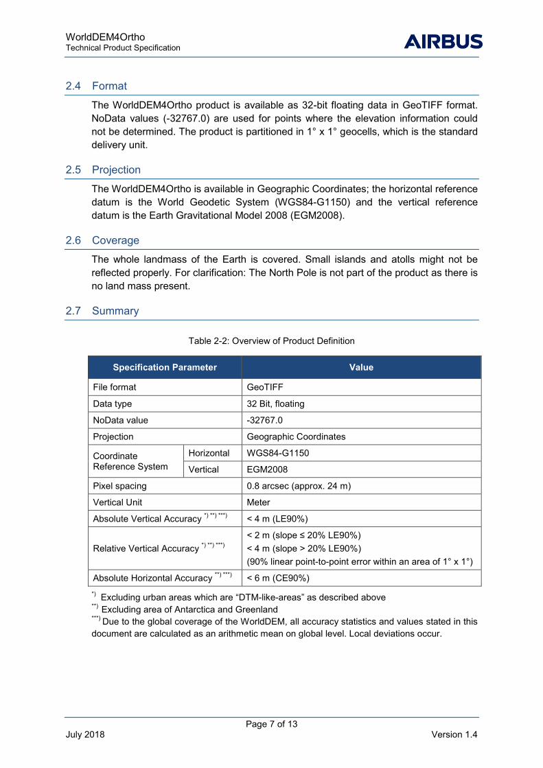
2.3 Pixel Spacing
The default grid spacing of the WorldDEM4Ortho product is 0.8 arc seconds (approx. 24 m) in latitude direction. In longitude direction the pixel spacing depends on the latitude as listed in Table 2-1.
Table 2-1: Pixel Spacing Depending on Latitude
Zone Latitude Band Latitude Pixel Spacing Longitude Pixel Spacing
I 0° - 50° North/South
0.8”
0.8”
II 50° - 60° North/South 1.2”
III 60° - 70° North/South 1.6”
IV 70° - 80° North/South 2.4”
V 80° - 85° North/South 4.0”
VI 85° - 90° North/South 8.0”
WorldDEM4Ortho Technical Product Specification
Page 7 of 13 July 2018 Version 1.4
2.4 Format
The WorldDEM4Ortho product is available as 32-bit floating data in GeoTIFF format. NoData values (-32767.0) are used for points where the elevation information could not be determined. The product is partitioned in 1° x 1° geocells, which is the standard delivery unit.
2.5 Projection
The WorldDEM4Ortho is available in Geographic Coordinates; the horizontal reference datum is the World Geodetic System (WGS84-G1150) and the vertical reference datum is the Earth Gravitational Model 2008 (EGM2008).
2.6 Coverage
The whole landmass of the Earth is covered. Small islands and atolls might not be reflected properly. For clarification: The North Pole is not part of the product as there is no land mass present.
2.7 Summary
Table 2-2: Overview of Product Definition
*) Excluding urban areas which are “DTM-like-areas” as described above **) Excluding area of Antarctica and Greenland ***) Due to the global coverage of the WorldDEM, all accuracy statistics and values stated in this document are calculated as an arithmetic mean on global level. Local deviations occur.
Specification Parameter Value
File format GeoTIFF
Data type 32 Bit, floating
NoData value -32767.0
Projection Geographic Coordinates
Coordinate Reference System
Horizontal WGS84-G1150
Vertical EGM2008
Pixel spacing 0.8 arcsec (approx. 24 m)
Vertical Unit Meter
Absolute Vertical Accuracy *) **) ***) < 4 m (LE90%)
Relative Vertical Accuracy *) **) ***) < 2 m (slope ≤ 20% LE90%) < 4 m (slope > 20% LE90%) (90% linear point-to-point error within an area of 1° x 1°)
Absolute Horizontal Accuracy **) ***) < 6 m (CE90%)
WorldDEM4Ortho Technical Product Specification
Page 8 of 13 July 2018 Version 1.4
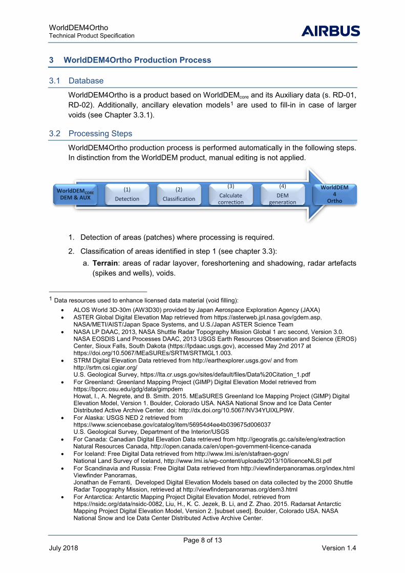
3 WorldDEM4Ortho Production Process
3.1 Database
WorldDEM4Ortho is a product based on WorldDEMcore and its Auxiliary data (s. RD-01, RD-02). Additionally, ancillary elevation models1 are used to fill-in in case of larger voids (see Chapter 3.3.1).
3.2 Processing Steps
WorldDEM4Ortho production process is performed automatically in the following steps. In distinction from the WorldDEM product, manual editing is not applied.
1. Detection of areas (patches) where processing is required.
2. Classification of areas identified in step 1 (see chapter 3.3): a. Terrain: areas of radar layover, foreshortening and shadowing, radar artefacts
(spikes and wells), voids.
1 Data resources used to enhance licensed data material (void filling):
• ALOS World 3D-30m (AW3D30) provided by Japan Aerospace Exploration Agency (JAXA) • ASTER Global Digital Elevation Map retrieved from https://asterweb.jpl.nasa.gov/gdem.asp,
NASA/METI/AIST/Japan Space Systems, and U.S./Japan ASTER Science Team • NASA LP DAAC, 2013, NASA Shuttle Radar Topography Mission Global 1 arc second, Version 3.0.
NASA EOSDIS Land Processes DAAC, 2013 USGS Earth Resources Observation and Science (EROS) Center, Sioux Falls, South Dakota (https://lpdaac.usgs.gov), accessed May 2nd 2017 at https://doi.org/10.5067/MEaSUREs/SRTM/SRTMGL1.003.
• STRM Digital Elevation Data retrieved from http://earthexplorer.usgs.gov/ and from http://srtm.csi.cgiar.org/ U.S. Geological Survey, https://lta.cr.usgs.gov/sites/default/files/Data%20Citation_1.pdf
• For Greenland: Greenland Mapping Project (GIMP) Digital Elevation Model retrieved from https://bpcrc.osu.edu/gdg/data/gimpdem Howat, I., A. Negrete, and B. Smith. 2015. MEaSURES Greenland Ice Mapping Project (GIMP) Digital Elevation Model, Version 1. Boulder, Colorado USA. NASA National Snow and Ice Data Center Distributed Active Archive Center. doi: http://dx.doi.org/10.5067/NV34YUIXLP9W.
• For Alaska: USGS NED 2 retrieved from https://www.sciencebase.gov/catalog/item/56954d4ee4b039675d006037 U.S. Geological Survey, Department of the Interior/USGS
• For Canada: Canadian Digital Elevation Data retrieved from http://geogratis.gc.ca/site/eng/extraction Natural Resources Canada, http://open.canada.ca/en/open-government-licence-canada
• For Iceland: Free Digital Data retrieved from http://www.lmi.is/en/stafraen-gogn/ National Land Survey of Iceland, http://www.lmi.is/wp-content/uploads/2013/10/licenceNLSI.pdf
• For Scandinavia and Russia: Free Digital Data retrieved from http://viewfinderpanoramas.org/index.html Viewfinder Panoramas, Jonathan de Ferranti, Developed Digital Elevation Models based on data collected by the 2000 Shuttle Radar Topography Mission, retrieved at http://viewfinderpanoramas.org/dem3.html
• For Antarctica: Antarctic Mapping Project Digital Elevation Model, retrieved from https://nsidc.org/data/nsidc-0082, Liu, H., K. C. Jezek, B. Li, and Z. Zhao. 2015. Radarsat Antarctic Mapping Project Digital Elevation Model, Version 2. [subset used]. Boulder, Colorado USA. NASA National Snow and Ice Data Center Distributed Active Archive Center.
WorldDEMCORE DEM & AUX
(1) Detection
(2) Classification
(3) Calculate
correction
(4) DEM
generation
WorldDEM 4
Ortho

WorldDEM4Ortho Technical Product Specification
Page 9 of 13 July 2018 Version 1.4
b. Hydrology: water ponds (lakes, reservoirs), rivers and coastal water
c. Urban areas: dense urban areas, single buildings including streets; urban areas with trees are partial included.
3. Correction of the classified areas:
a. Small voids and artefacts of any category are interpolated considering the surrounding pixels.
b. For terrain-based artefacts and larger voids are filled with ancillary DEM data.
c. Water based artefacts are flattened onto a single water level derived from shoreline pixels. Coastal water is set to sea level 0. Rivers are stepped with a flow following the surrounding shorelines (no hydrological enforcement).
d. Areas classified as “urban” are levelled to ground approximately (“DTM-like-area”) as in large and dense urban areas often no reliable ground information can be determined.
4. Implementation of all replacement patches into the WorldDEMcore followed by post-editing filter operations.
The generation of the WorldDEM4Ortho product is performed on geocell basis. After that an edge matching procedure is implemented to match the adjacent geocells against each other (due to different pixel spacing no edge matching possible between the different latitude zones as specified in table 2-1).
3.3 WorldDEM4Ortho Processing Specification
In this chapter the processing rules applied to the identified classes are described in the categories “terrain”, “hydrology” and “urban area”.
3.3.1 Terrain Feature Processing The terrain editing comprises the correction of terrain artifacts caused by SAR specific characteristics or DSM processing. The processing rules applied during the terrain processing are summarized in the following table.
Table 3-1: Terrain Feature Processing
Feature Procedure
Layover, Foreshortening (SAR specific features)
Patches of ≤ 16 pixels: • Interpolation considering pixels adjacent to the patch
Patches of > 16 pixels: • Classification of layover areas using knowledge based operations • Replacement of identified areas using ancillary DEM data
Shadow (SAR specific feature)
Patches of ≤ 16 pixels: • Interpolation considering pixels adjacent to the patch
Patches of > 16 pixels: • Classification of areas using iterative algorithms • Replacement of identified areas using ancillary DEM data

WorldDEM4Ortho Technical Product Specification
Page 10 of 13 July 2018 Version 1.4
Feature Procedure
Spikes & Wells • Interpolation considering pixels adjacent to the patch
Figure 3-1: Void, layover and shadow areas (left), correction via infill of ancillary DEM data (right)
3.3.2 Hydrologic Feature Processing In this process lakes (incl. reservoirs), rivers and oceans are considered according to the water portrayal in the used ancillary data (amplitude mosaic). Water surfaces not detectable as water are not considered as water and remain untreated, e.g. frozen water, narrow and small rivers, etc. In limited cases, an over-detection of water occurs.
Rivers are implemented with height levels oriented at the shoreline structure. This does not include a proper hydro-enforcement (runoff direction), e.g. no monotonic river flow is implemented.
Water height level in lakes or rivers is calculated geocell-individually. Thus, for trans-geocell lakes or rivers differences in water height levels arise at borders between two (or more) geocells. A border matching process provides homogeneous transition between the water levels on adjacent geocells.
The following table describes the hydrologic feature processing rules.
Table 3-2: Hydrologic Feature Processing
Feature Procedure
Water basins • Identification of basin extent • Levelling of identified area considering shoreline height
values from DEM
Rivers
• Identification of river extent • Levelling of identified area considering shoreline height
values from DEM • Terracing of rivers to adapt river course to terrain
Coastal water • Identification of water extent • Levelling of identified area and set to sea level (0m)
WorldDEM4Ortho Technical Product Specification
Page 11 of 13 July 2018 Version 1.4
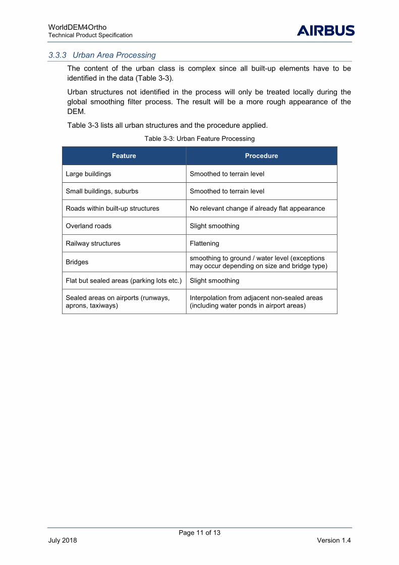
3.3.3 Urban Area Processing The content of the urban class is complex since all built-up elements have to be identified in the data (Table 3-3).
Urban structures not identified in the process will only be treated locally during the global smoothing filter process. The result will be a more rough appearance of the DEM.
Table 3-3 lists all urban structures and the procedure applied.
Table 3-3: Urban Feature Processing
Feature Procedure
Large buildings Smoothed to terrain level
Small buildings, suburbs Smoothed to terrain level
Roads within built-up structures No relevant change if already flat appearance
Overland roads Slight smoothing
Railway structures Flattening
Bridges smoothing to ground / water level (exceptions may occur depending on size and bridge type)
Flat but sealed areas (parking lots etc.) Slight smoothing
Sealed areas on airports (runways, aprons, taxiways)
Interpolation from adjacent non-sealed areas (including water ponds in airport areas)

WorldDEM4Ortho Technical Product Specification
Page 12 of 13 July 2018 Version 1.4
4 Naming Convention
The file naming convention is standardized as follows:
WorldDEM_WDO_BB_YDD_EE_XGGG_HH
Example: WorldDEM_WDO_08_S33_00_E138_00
The bold letters are fixed and remain unchanged at all times. The other letters have the meanings as explained in Table 4-1. The file name always corresponds to the lower left corner coordinate (centre of Southwest pixel) of the AoI or bounding box corner, respectively.
Table 4-1: Naming Convention
Letter Meaning
WDO DEM Product: • WDO = WorldDEM4Ortho
BB Pixel Spacing: • 08: 0.8-arcsecond grid
YDD_EE_XGGG_HH Geo-location of lower left corner in decimal degree e.g. N20_00_W120_00
Y N (North) or S (South) hemisphere
DD Latitude in Degree (Range: 0 - 90)
EE Decimal Latitude Degree (Range: 0 - 99)
X W (West) or E (East)
GGG Longitude in Degree (Range: 0 - 180)
HH Decimal Longitude Degree (Range: 0 - 99)

WorldDEM4Ortho Technical Product Specification
Page 13 of 13 July 2018 Version 1.4
5 Product File Structure
All product files are structured in the delivery folder (see Figure 5-1) as follows:
■ xml file (Metadata)
■ INFO folder containing Applicable Contract / Licence Terms document (pdf)
■ DEM folder containing elevation data (GeoTIFF)
Figure 5-1: Product File Structure