World Ocean Database and World Ocean Atlas 2009556 11,652 14,208 Other data in WOD09: Meteorological...
23
1 World Ocean Database and World Ocean Atlas 2009 Hernan Garcia, Tim Boyer, Sydney Levitus, Ricardo Locarnini, John Antonov, Olga Baranova, Dan Seidov, Igor Smolyar, Daphne Johnson, Alexey Mishonov, and Melissa Zweng PICES 2009 Annual Meeting (Jeju, Korea) National Oceanographic data Center, USA
Transcript of World Ocean Database and World Ocean Atlas 2009556 11,652 14,208 Other data in WOD09: Meteorological...

1
World Ocean Database and World
Ocean Atlas 2009Hernan Garcia, Tim Boyer, Sydney Levitus, Ricardo Locarnini,
John Antonov, Olga Baranova, Dan Seidov, Igor Smolyar, Daphne Johnson, Alexey Mishonov, and Melissa Zweng
PICES 2009 Annual Meeting (Jeju, Korea)
National Oceanographic data Center, USA

2
OUTLINEWorld Ocean Database (WOD) & World Ocean
Atlas (WOA) 2009.
Value of historical, integrated databases to examine basin-scale variability.
Value of data sharing
3
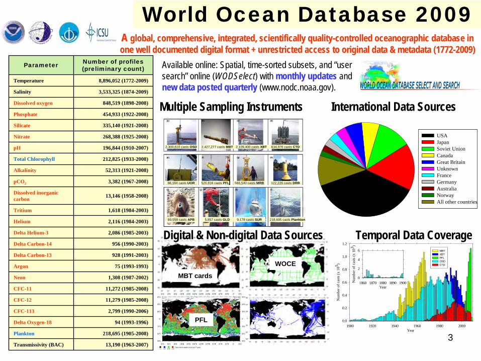
World Ocean Database 2009
Available online: Spatial, time-sorted subsets, and “user search” online (WODSelect) with monthly updates and new data posted quarterly (www.nodc.noaa.gov).
Digital & Non-digital Data Sources
Multiple Sampling Instruments International Data Sources
A global, comprehensive, integrated, scientifically quality-controlled oceanographic database in one well documented digital format + unrestricted access to original data & metadata (1772-2009)
Parameter Number of profiles (preliminary count)
Temperature 8,896,052 (1772-2009)
Salinity 3,533,325 (1874-2009)
Dissolved oxygen 848,519 (1898-2008)
Phosphate 454,933 (1922-2008)
Silicate 335,140 (1921-2008)
Nitrate 268,388 (1925-2008)
pH 196,844 (1910-2007)
Total Chlorophyll 212,825 (1933-2008)
Alkalinity 52,313 (1921-2008)
pCO2 3,382 (1967-2008)
Dissolved inorganic carbon 13,146 (1958-2008)
Tritium 1,618 (1984-2003)
Helium 2,116 (1984-2003)
Delta Helium-3 2,086 (1985-2003)
Delta Carbon-14 956 (1990-2003)
Delta Carbon-13 928 (1991-2003)
Argon 75 (1993-1993)
Neon 1,308 (1987-2002)
CFC-11 11,272 (1985-2008)
CFC-12 11,279 (1985-2008)
CFC-113 2,799 (1990-2006)
Delta Oxygen-18 94 (1993-1996)
Plankton 218,695 (1905-2008)
Transmissivity (BAC) 13,190 (1963-2007)
2,300,610 casts OSD 2,427,277 casts MBT 2,109,400 casts XBT 634,976 casts CTD
88,184 casts UOR 520,816 casts PFL 566,540 casts MRB 122,226 casts DRB
89,558 casts APB 5,857 casts GLD 9,178 casts SUR 218,695 casts Plankton
PFL
WOCE
MBT cards
Year1900 1920 1940 1960 1980 2000
Num
ber o
f cas
ts (x
105 )
0.0
0.2
0.4
0.6
0.8
1.0
1.2
MBT XBT PFL OSD CTD
Year1860 1870 1880 1890 1900N
umbe
r of c
asts
(x 1
03 )
0
2
4
6
Temporal Data Coverage
USAJapanSoviet UnionCanadaGreat BritainUnknownFranceGermanyAustraliaNorwayAll other countries

4
World Ocean database (WOD) and World Ocean Atlas (WOA) are made World Ocean database (WOD) and World Ocean Atlas (WOA) are made possible possible because of the data that scientists and institutions worldwide pbecause of the data that scientists and institutions worldwide provide to national, rovide to national,
regional, and World Data Centers. regional, and World Data Centers. NODC is dedicated to providing all available NODC is dedicated to providing all available oceanographic data to as wide an audience as possible without reoceanographic data to as wide an audience as possible without restrictionstriction
WOD also relies on voluntary data contributions from1.1. IOC Member States through the IOC/IODE system and the InternatioIOC Member States through the IOC/IODE system and the International Council for nal Council for
Science (ICSU) WDC systemScience (ICSU) WDC system2.2. NODC bilateral agreements and international exchangesNODC bilateral agreements and international exchanges3.3. Data from national and international projects and databases: GODData from national and international projects and databases: GODAR, GTSPP, AR, GTSPP,
GLOBEC, MEDAR/MEDATLAS, WOCE, JGOFS, CLIVAR, Argo, CCHDO, ICES, GLOBEC, MEDAR/MEDATLAS, WOCE, JGOFS, CLIVAR, Argo, CCHDO, ICES, PISCO, and many othersPISCO, and many others……
NODC Data Producers:
IOOS

5Y ear
20 03 20 04 200 5 2 006 20 07 2 008 2 009 20 10
Num
ber
of st
atio
ns d
ownl
oade
d (x
106 )
0
2 0
4 0
6 0
8 0
10 0
12 0
14 0
2 0 0 3 2 0 0 5 2 0 0 5 2 0 0 6 2 0 0 7 2 0 0 8 2 0 0 9
20 03200 4
20 05 2 0062 007
200 8
20 09W O D 01 W O D 05
> 2 .0 2 b illio n sta tio n s d o w n lo ad ed since A pril 2 00 3
WOD and objective analyses are used by the research and operational communities as evidenced by number of citations in the scientific literature and data downloads
Impact: Science Citations and usage
Year
1970 1980 1990 2000 2010
Num
ber
of st
atio
ns (x
106 )
0
2
4
6
8
10
1.49
2.54
4.49
5.29
7.04
7.90
8.89
0.40
1.28 1.482.12
2.64
3.52
NODC1974
NODC1991
WOA94
WOD98
WOD01
WOD05
WOD09
Temperature
Salinity
Output: GrowthThe Global Oceanographic Data Archaeology and Rescue (GODAR) and WOD projects have recovered and made available online without restrictions much historical and modern data (preliminary data counts)
Since April 2003; >2.02 billion stations (1,201 gigabytes) downloaded. About half the data have been served to countries other than the USA (>80% of OSD data in WOD09 are from non-USA data sources).
NODC, IODE, ICSU, and many others are recognized for their achievements. How successful are they based on IMPACT and OUTPUT?
0
50
100
150
200
250
300
350
400
450
500
1983
1984
1985
1986
1987
1988
1989
1990
1991
1992
1993
1994
1995
1996
1997
1998
1999
2000
2001
2002
2003
2004
2005
2006
2007
2008
Year
# C
itatio
ns
WOD05 + WOA05WOD01 + WOA01WOD98 + WOA98WOA94Clim. Atlas of the World Ocean (1982)
Total Number of Citations = 5,925

6
INSTRUMENT TYPE WOD05 ADDED WOD09 % increase
1 Bottle (OSD) 2,258,437 272,431 2,530,868 12.1
2 High Resolution Conductivity/Temperature/Depth (HCTD) 443,953 191,023 634,976 43.0
3 Mechanical Bathythermograph (MBT) 2,421,940 5,337 2,427,277 0.2
4 Expendable Bathythermograph (XBT) 1,930,413 178,987 2,109,400 9.3
5 Moored Buoys (e.g., TAO, TRITON, PIRATA) 445,371 121,169 566,540 27.2
6 Drifting Buoys 108,564 13,662 122,226 12.6
7 Profile Floats (P-ALACE, SOLO, APEX, PROVOR) 168,988 351,818 520,816 208.2
8 Undulating Ocean Recorder (e.g., Towed CTD) 46,699 41,485 88,184 88.8
9 Glider 338 5,519 5,857 1632.8
10 Autonomous Pinniped Bathythermograph 75,665 13,933 89,558 18.4
World Ocean Database 2009 (WOD09).
NOAA NODC/WDC

7
Year1900 1920 1940 1960 1980 2000
Num
ber
of c
asts
(x 1
05 )
0.0
0.5
1.0
1.5
2.0
TemperatureSalinityOxygenPhosphate
Year1770 1800 1830 1860 1890N
umbe
r of
cas
ts (x
103 )
0.0
0.5
1.0
1.5
2.0
OSD
XCTD
PFL
MBT
DBT
DRBUOR
APB SUR
WOD09 spatial and temporal data coverage
APB: Autonomous Pinniped Bathythermograph; MRB: Moored buoy data; DRB: Drifting buoy data; UOR: Undulating Oceanographic Recorder; GLD: Glider data
CTD XBT
Plankton
OSD: Ocean Station data; MBT: Mechanical bathythermograph; XCTD: Expendable CTD; DBT: Digital Bathythermograph; PFL: Profiling Float

8
DATASET SOURCE
OSDBottle, low-resolution Conductivity-Temperature- Depth (CTD), low-resolution XCTD data, and plankton data
CTD High-resolution Conductivity-Temperature-Depth (CTD) data and high-resolution XCTD data
MBT Mechanical Bathythermograph (MBT) data, DBT, micro-BT
XBT Expendable (XBT) data
SUR Surface only data (bucket, thermosalinograph)
APBAutonomous Pinniped Bathythermograph - Time-Temperature-Depth recorders attached to elephant seals
MRBMoored buoy data from TAO (Tropical Atmosphere-Ocean), PIRATA (moored array in the tropical Atlantic), MARNET, and TRITON (Japan- JAMSTEC)
PFL Profiling float data
DRB Drifting buoy data from surface drifting buoys with thermistor chains
UORUndulating Oceanographic Recorder data from a Conductivity/Temperature/Depth probe mounted on a towed undulating vehicle
GLD Glider data
VariablesDATASETS
OSD MBT XBT CTD MRB TotalBottom depth (m) 1,451,069 617,108 444,565 352,007 2,864,749
Water color (Forel-Ule color scale) 231,968 12,411 429 1,087 245,895
Secchi disk visibility depth (m) 372,236 12,146 447 1,952 386,781
Wave direction (WMO 0877) 302,044 29,843 30,529 3,853 366,269
Wave height (WMO 1555) 164,546 114,145 47,257 9,768 335,716
Sea state (WMO 3700) 511,282 478,000 53,963 27,368 1,070,613
Wind force (Beafort Scale) 420,311 14,444 2,199 3,948 440,902
Wave period (WMO 3155 or NODC 0378) 104,604 34,385 37,765 9,439 186,193
Wind direction (WMO 0877) 954,473 653,395 151,590 51,571 348,776 2,159,805
Wind speed (in knots) 531,432 673,101 153,368 46,986 351,301 1,756,188
Barometric pressure (millibar) 658,706 337,933 26,181 46,764 2,546 1,072,130
Dry bulb temperature (°C) 891,584 622,633 135,336 50,644 375,780 2,075,977
Wet bulb temperature (°C) 230,377 495,859 49,841 35,062 811,139
Weather condition (WMO 4501 and WMO 4677) 628,704 514,729 41,754 35,194 1,220,381
Cloud type (WMO 0500) 322,837 25,453 14,321 20,197 382,808
Cloud cover (WMO 2700) 604,530 523,929 25,751 29,515 1,183,725
Horizontal visibility (WMO 4300) 50,952 185,428 857 22,666 259,903
Reference/Sea surface temperature (°C) 24,876 1,172,477 115,942 391 1,421 1,315,107
Absolute air humidity (g m-3) 56,451 1,565 82 58,098
Sea surface salinity 2,556 11,652 14,208
Other data in WOD09: Meteorological and sea-state

9
ID DESCRIPTION1 NODC Accession Number2 NODC Project Code3 WOD Platform Code4 Institution Code5 Cast/Tow number7 Originator’s station number8 Depth Precision9 Ocean Weather Station10 Bottom Depth (meters)11 Cast Duration (hours)12 Cast Direction (down assumed)13 High-resolution pairs 14 Water Color 15 Water Transparency (Secchi disk)16 Wave Direction (WMO 0877 or NODC 0110) 17 Wave Height (WMO 1555 or NODC 0104)18 Sea State (WMO 3700 or NODC 0109)19 Wind Force (Beaufort scale or NODC 0052)20 Wave Period (WMO 3155 or NODC 0378)21 Wind Direction (WMO 0877 or NODC 0110)22 Wind Speed (knots)23 Barometric Pressure (millibars)24 Dry Bulb Temperature (�C)25 Wet Bulb Temperature (�C)26 Weather Conditions (WMO 4501/4677)27 Cloud Type (WMO 0500 or NODC 0053)28 Cloud Cover (WMO 2700 or NODC 0105)29 Probe Type30 Calibration Depth31 Calibration Temperature32 Recorder (WMO 4770)33 Depth Correction 34 Bottom Hit
ID DESCRIPTION35 Digitization Method (NODC 0612)36 Digitization Interval (NODC 0613)37 Data Treatment and Storage Method (NODC 0614)38 Trace Correction39 Temperature Correction40 Instrument for reference temperature (NODC 0615)41 Horizontal visibility (WMO Code 4300)45 Absolute Humidity (g/m3)46 Reference/Sea Surface Temperature47 Sea Surface Salinity48 Year in which probe was manufactured49 Speed of ship (knots) when probe was dropped54 Depth fix71 Real time72 XBT Wait (code no longer used)73 XBT Frequency (code no longer used)74 Oceanographic measuring vehicle77 xCO2 in atmosphere (ppm)84 ARGOS fix code85 ARGOS time (hours) from last fix86 ARGOS time (hours) to next fix87 Height (meters) of XBT launch88 Depth of sea surface sensor91 Database ID92 UKHO Bibliographic Reference Number93 Consecutive profile in a tow segment94 WMO Identification Code95 Originator’s Depth unit 96 Originator’s flags97 Water Sampler98 ARGOS ID number99 Time stamp (YYYYJJJ, Y=year, J= year day) to
ASCII version of cast was created
Secondary MetadataID DESCRIPTION1 Accession number 2 Project 3 Scale 4 Institution 5 Instrument 6 Methods 8 Originator’s units 10 Equilibrator type 11 Filter type and size 12 Incubation time 13 CO2 sea warming 15 Analysis temperature 16 Uncalibrated 17 Contains nitrite 18 Normal Standard
Seawater batch 19 Adjustment
Metadata available in WOD09
Variable specific metadata
Other metadata: Plankton & biological metadata
(not shown)
Primary header metadata: Such as unique cast number, ISO country code, cruise number, date, time, position, and the number and type of variables in the cast.
Character metadata: Originator’s cruise, originator’s cast, & Principal Investigator’s codes.

10
WODSelect: database select and search

11
WOD Generalities1) Database development and management is labor–intensive.
2) Nearly every data set we process has some type of problem that requires human intervention.
3) We work with data providers to provide feedback on problems we encounter. Users can provide feedback ([email protected])
Online availability of the original and processed data
• WOD produced every 3-4 years with full quality control. • Corrections to data and metadata available on a monthly basis
• New data updates available quarterly (with limited QC)
WOD is a work in progress

12
A. QC OF OBSERVED LEVEL DATA1. Format conversion
2. Check position/date/time
3. Assignment of cruise and cast numbers
4. Speed check
5. Duplicate checks
6. Depth inversion and depth duplication checks
7. High-resolution pairs check
8. Range checks on observed level data
9. Excessive gradient checks
10. Observed level density checks
11. Vertical interpolation method
B. QC STANDARD LEVEL DATA
12. Density inversion & static stability check
13. Statistical analysis
14. Objective analysis
15. Subjective analysis
Zonal Mean
Annual Mean (OA)
Seasonal Mean (OA)
Monthly Mean (OA)
Seasonal Mean
Monthly Mean (OA)
Annual Mean Seasonal Mean
Annual Mean
Seasonal Mean (OA)
Z ≤ 1500 m Z > 1500 m
Mean of 3 months
Mean of 12 months
Mean of 3 months
Mean of 4 seasons
Annual Mean
Mean of 4 Seasons
First-guess field used to calculate mean fieldMean of climatologiesFinal mean field
Legend:OA - Objectively analyzed field
Z - Depth
Quality Control Objective Analysis
Loop
13
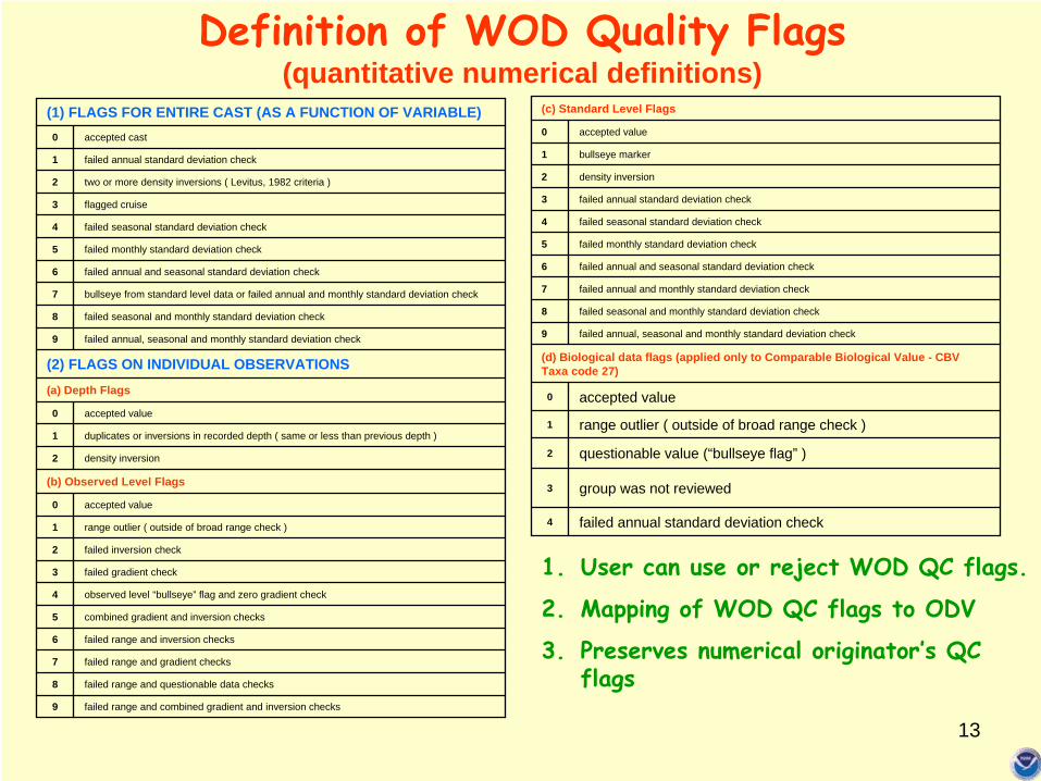
(c) Standard Level Flags
0 accepted value
1 bullseye marker
2 density inversion
3 failed annual standard deviation check
4 failed seasonal standard deviation check
5 failed monthly standard deviation check
6 failed annual and seasonal standard deviation check
7 failed annual and monthly standard deviation check
8 failed seasonal and monthly standard deviation check
9 failed annual, seasonal and monthly standard deviation check
(d) Biological data flags (applied only to Comparable Biological Value - CBV Taxa code 27)
0 accepted value
1 range outlier ( outside of broad range check )
2 questionable value (“bullseye flag” )
3 group was not reviewed
4 failed annual standard deviation check
(1) FLAGS FOR ENTIRE CAST (AS A FUNCTION OF VARIABLE)0 accepted cast
1 failed annual standard deviation check
2 two or more density inversions ( Levitus, 1982 criteria )
3 flagged cruise
4 failed seasonal standard deviation check
5 failed monthly standard deviation check
6 failed annual and seasonal standard deviation check
7 bullseye from standard level data or failed annual and monthly standard deviation check
8 failed seasonal and monthly standard deviation check
9 failed annual, seasonal and monthly standard deviation check
(2) FLAGS ON INDIVIDUAL OBSERVATIONS(a) Depth Flags
0 accepted value
1 duplicates or inversions in recorded depth ( same or less than previous depth )
2 density inversion
(b) Observed Level Flags
0 accepted value
1 range outlier ( outside of broad range check )
2 failed inversion check
3 failed gradient check
4 observed level “bullseye” flag and zero gradient check
5 combined gradient and inversion checks
6 failed range and inversion checks
7 failed range and gradient checks
8 failed range and questionable data checks
9 failed range and combined gradient and inversion checks
Definition of WOD Quality Flags (quantitative numerical definitions)
1.
User can use or reject WOD QC flags.
2.
Mapping of WOD QC flags to ODV
3.
Preserves numerical originator’s QC flags

14
Before QC
Objective and subjective QC: Phosphate example
After QCPhosphate (µM) Phosphate (µM)
Temperature
Phos
phat
e (µ
M)
Dep
th (m
)
Dep
th (m
)
Temperature
Phos
phat
e (µ
M)
40-°
50°N
160°-170°E
40-°
50°N
160°-170°E
~17% of the phosphate profiles are marked as “questionable”

15
Impact of Quality Control Impact of Quality Control January, 800 m depth temperature climatologyJanuary, 800 m depth temperature climatology
After After ““automaticautomatic”” QCQC After After ““automatic and subjectiveautomatic and subjective”” QCQC
Some automatic checks performed:Some automatic checks performed:•• Standard deviationStandard deviation•• RangeRange•• Vertical gradientVertical gradient•• SpikeSpike•• Density inversionDensity inversion•• Cruise speed Cruise speed
Producing WOD series is labor-intensive.
Ocean data are sparse.

16
IODE Group of Experts on Biological and Chemical Data Management and Exchange Practices (GE-BICH)
1st Workshop on Quality Control and Quality Assurance of Chemical Oceanographic Data Collections
–
Ostende, Belgium, 8-11 February 2010 (sponsored by IOC)
Convenors: Hernan Garcia (NODC, [email protected]) & Gwenaëlle Moncoiffe (BODC, [email protected])
Goal: Explore a minimum set of QC technical procedures and QC flags for chemical data starting with in situ dissolved inorganic nutrients and dissolved oxygen.

17
Data Products based on Data Products based on WOAWOA//WOD05WOD05 (09 (09 ……))

18
World Ocean Atlas Series
¼° Temperature & Salinity

19
Global ocean heat content (1955–2008)
Levitus et al., 2009
IPCC 2007
Updated quarterly

20Antonov et al., 2005; 2009
Thermosteric Sea Level Variability (1955-2008)

21
Atlantic
World
Pacific
Indian
Linear Trend in Salinity (x 10-4 year-1) of the zonally averagedpentadal salinity anomaly (1955/59 to 1994/98)
Blue (-)Red (+)
CI=
5 x 10⁻⁴ yr-1
Boyer et al., 2005

22Garcia et al., 2005
Variability in O2 , AOU, and heat content (0-100 m)
83-98 NH: -30 Tmol O2 /decade
~ -4 nmol O2 per J of heat
O2
AOU
Heat

23
1.
Make it easier and routine for data providers to submit data to data centers (partnerships).
2.
Peer reviewed “data publication”
recognition equal to a peer-reviewed journal publication (work credit).
3.
Associate research funding with data sharing before and after publication.
4.
Increase funding (1) to manage observations and (2) to make the data available in digital usable form.
Data sharing and data integration are required to monitor the oceans
The Importance of Long-term Preservation and Accessibility of Geophysical Data (Statement adopted by AGU Council 29 May 1997, Reaffirmed 2001, 2005, 2006, Revised and Reaffirmed May 2009).
Editorial (nature), Nature 461, 145 (10 | doi:10.1038/461145a; 23 September 2009
PICES Technical Committee on Data Exchange (TCODE)
The vision of the Global Earth Observation System of Systems (GEOSS) is “to realize a future wherein decisions and actions for the benefit of humankind are informed via coordinated, comprehensive and sustained Earth observations and information.” (GEO Data Sharing Principles Implementation)
Editorial (nature), Nature 461, 145 (10 | doi:10.1038/461145a; 23 September 2009