World Heritage and Biosphere Reserves: observation platforms for societal benefits of ecosystems...
21
World Heritage and Biosphere Reserves: observation platforms for societal benefits of ecosystems Natarajan Ishwaran International Centre on Space Technologies for Natural and Cultural Heritage (HIST), CEODE, China ISRSE35 Side Meeting GEO Ecosystems SBA Work Meeting (Beijing International Convention Center) 13:30~17:30 (UTC+8), 21 April, 2013
-
Upload
lawrence-blankenship -
Category
Documents
-
view
214 -
download
1
Transcript of World Heritage and Biosphere Reserves: observation platforms for societal benefits of ecosystems...
World Heritage and Biosphere Reserves: observation platforms for societal benefits of ecosystems
Natarajan Ishwaran
International Centre on Space Technologies for Natural and Cultural Heritage (HIST), CEODE, China
ISRSE35 Side MeetingGEO Ecosystems SBA Work Meeting
(Beijing International Convention Center)13:30~17:30 (UTC+8), 21 April, 2013
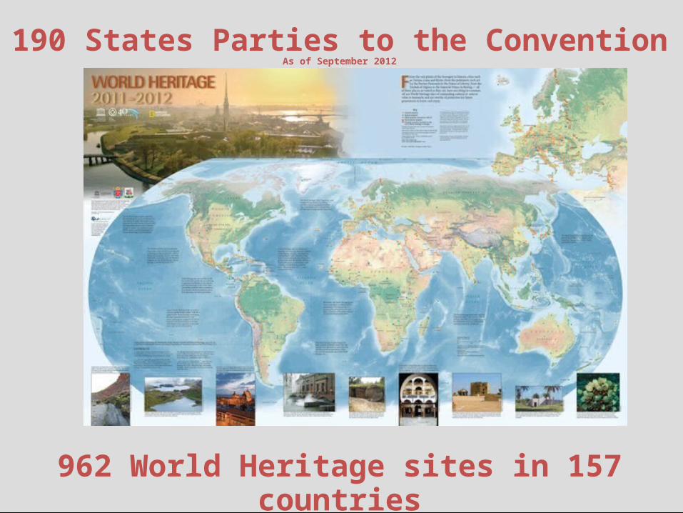
190 States Parties to the ConventionAs of September 2012
962 World Heritage sites in 157 countriesAs of August 2012

Key Concept: Outstanding Universal Value
OUTSTANDING UNIVERSAL VALUEM
EETS
CRT
IERI
A
INTE
GRI
TY A
ND
AU
THEN
TICI
TY
PRO
TECT
ION
AN
D
MAN
AGEM
ENT
Illustration of the three pillars of Outstanding Universal Value. All three must be in place for a property to meet the requirements of the World Heritage LIst
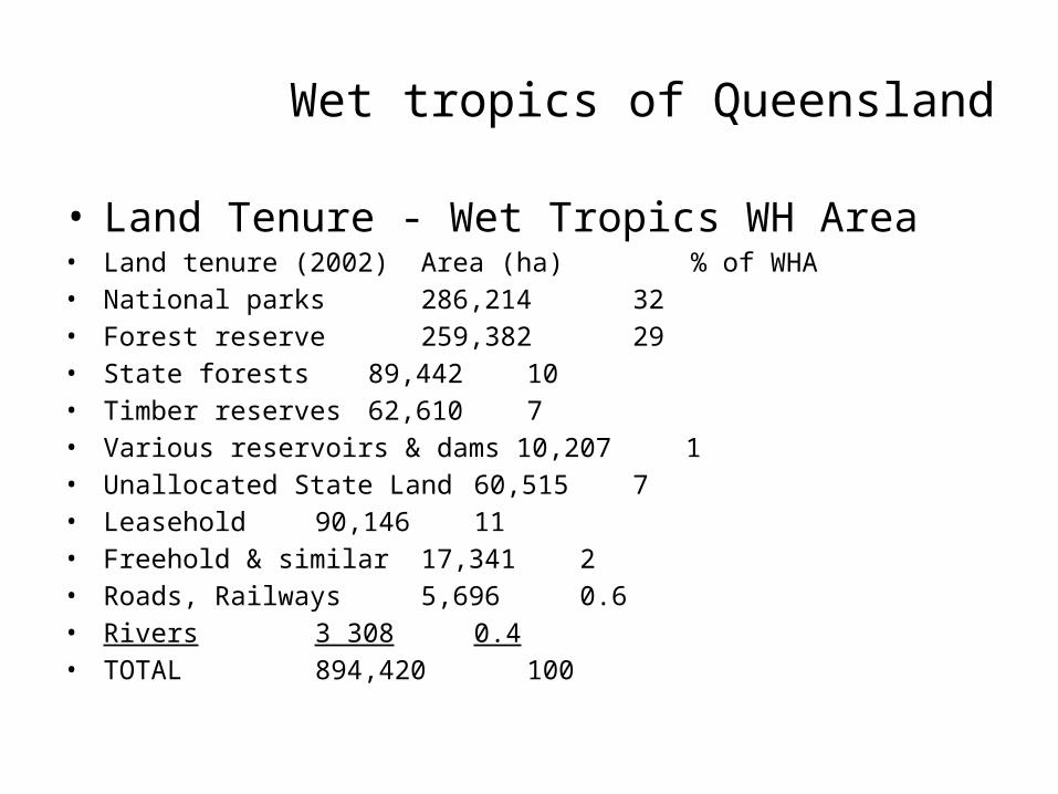
Wet tropics of Queensland
• Land Tenure - Wet Tropics WH Area• Land tenure (2002) Area (ha) % of WHA• National parks 286,214 32• Forest reserve 259,382 29• State forests 89,442 10• Timber reserves 62,610 7• Various reservoirs & dams 10,207 1• Unallocated State Land 60,515 7• Leasehold 90,146 11• Freehold & similar 17,341 2• Roads, Railways 5,696 0.6• Rivers 3 308 0.4• TOTAL 894,420 100

Second Consultation Meeting of the International Support Group (ISG)
• Other Matters
Closure of the Meeting
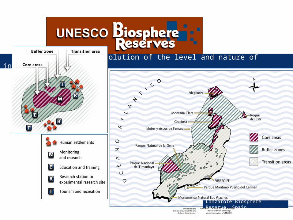
Evolution of the level and nature of integration
Lanzarote Biosphere Reserve, Spain

Dinghushan BR ,1979

R e s e r v a d a B i o s f e r ad a C a a t i n g aR e s e r v a d a B i o s f e r ad a A m a z ô n i a C e n t r a l R e s e r v a d a B i o s f e r ad a M a t a A t l â n t i c a P a r áA c r e M a t o G r o s s oR o n d o n i aA m a z o n a sR o r a im a A m a p á
P i a u íB a h i aM i n a s G e r a i sS ã o P a u l oP a r a n áG o i á s R i o d e J a n e i r oE s p í r it oS a n t oP a r a í b aA l a g o a sS e r g i p eP e r n a m b u c oR i o G r a n d ed o N o r t eC e a r áM a r a n h ã oT o c a n t i n s
R i o G r a n d e d o S u lS a n t a C a t a r i n aM a t o G r o s s o d o S u l D . F .
5 0 0 K m5 0 0 0N
P r o j e ç ã o g e o g r á f i c a D a t u m : W G S 8 4
B R A S I L
S P1 9 3S P1 3 9 B R1 1 6
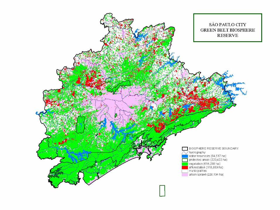
B R1 1 6B R1 1 6S P5 5B R1 1 6 S P2 2 6R E G IÃ O M E TR O P O L ITA N AD E S Ã O P A U LO R i o sE s t r a d a sZ o n a s N ú c l e oU n i d a d e s d e C o n s e r v a ç ã oR e s e r v a d a B i o s f e r a d o C i n t u r ã o V e r d e d a C i d a d e d e S ã o P a u l o( S i s t e m a R B M A )O C E A N O A T L Â N T I C O
R e s e r v a d a B i o s f e r ad o C i n t u r ã o V e r d ed a C i d a d e d e S ã o P a u l o( S i s t e m a R B M A )
F o n t e : C O B R A M A B , a d a p a t a d o p o r R e s e r v a d a B i o s f e r a d o C i n t u r ã o V e r d e d a C i d a d e d e S ã o P a u l o .
R e s e r v a d a B i o s f e r ad o P a n t a n a lR e s e r v a d a B i o s f e r ad o C e r r a d o
Reserva da B iosferada Caatinga
Reserva da B iosferada Am azônia Centra l
Reserva da B iosferada Mata Atlântica
Pará
Acre
Mato Grosso
Rondonia
Amazonas
RoraimaAmapá
Piauí
Bahia
M inas Gerais
São Paulo
Paraná
Goiás
Rio de Janeiro
EspíritoSanto
Paraíba
Alagoas
Sergipe
Pernambuco
Rio Grandedo Norte
CearáMaranhão
Tocantins
Rio Grande do Sul
Santa Catarina
Mato Grosso do Sul
D.F.
5 0 0 K m5 0 0 0
N
Projeção geográfica Datum: WGS 84
BR A S IL
SP1 93
SP1 3 9
B R1 1 6
B R1 1 6
B R1 1 6
SP5 5
B R1 1 6
SP2 2 6
REG IÃO M ETRO PO LITANADE SÃO PAULO
Rios
Estradas
Zonas NúcleoUnidades de Conservação
Reserva da B iosfera do C inturão Verde da C idade de São P aulo(S istem a RBMA )
LÂNTICO
Reserva da B iosferado C inturão Verdeda C idade de São P aulo(S istem a RBMA )
Fonte: COBRAMAB, adapatado por Reserva da Biosfera do Cinturão Verde da Cidade de São Paulo.
Reserva da B iosferado Pantanal
Reserva da B iosferado Cerrado
THE BRAZILIAN NETWORK OF BIOSPHERE RESERVES
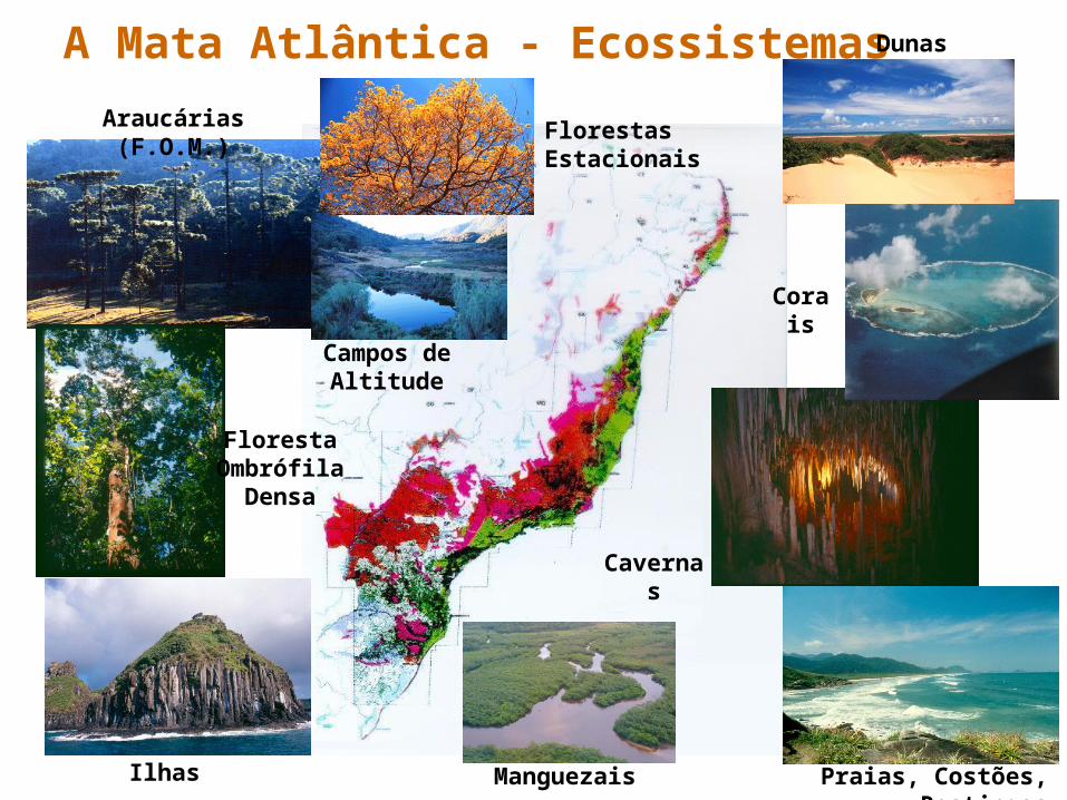
A Mata Atlântica - Ecossistemas
Ilhas Manguezais Praias, Costões, Restingas
Floresta Ombrófila
Densa
Araucárias (F.O.M.)
Cavernas
Corais
Florestas Estacionais
Campos de Altitude
Dunas

FOREST COVER INSÃO PAULO STATE
1854 1886
1907 1920 1935
1952 1962 1973
Initial forest cover
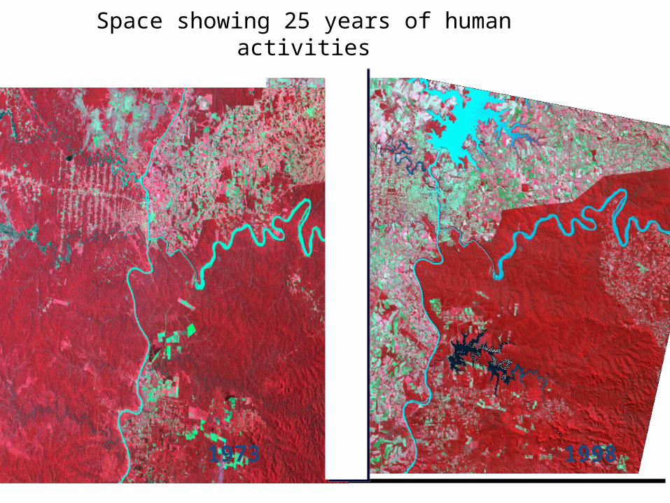
19981973
Space showing 25 years of human activities
World Heritage at 40 (2012) – how the World Heritage Convention
contributes to sustainable development
• Sustainable development, almost by definition, is on a scale that goes well beyond the scope of a World Heritage site, so that management and planning needs must be more integrated in territorial and regional strategies – and so the results and repercussions of these actions reflect upon our larger communities and eventually our global community as a whole.
• The aim of the World Heritage Convention is the identification, protection, conservation, presentation and transmission……. The text of the Convention, adopted in 1972, does not make any specific mention of the term “sustainable development” but it does carry the spirit and promise of sustainability in its insistence that culture and nature form a single, closed continuum of the planet’s resources……..

Roulos
AngkorAngkor
Banteay Srei
Tonle Sap Lake
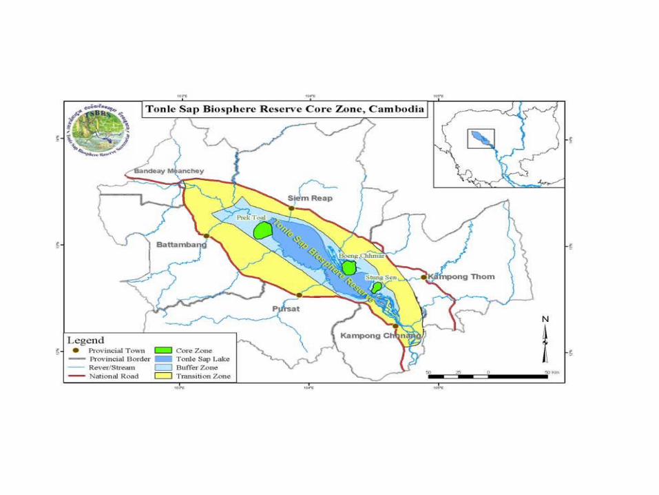

The Angkor Heritage Landscape – Building a database and guiding the future of its conservation and sustainable development
Defining the Angkor Heritage Landscape
– Angkor WH site
– The catchment of the three rivers that made up the ancient Angkor Hydraulic System (Siam Reap, Roulos and Puok)
– The Kulen mountain where three rivers originate
– Parts of the northern/northeastern parts of the Tonle Sap lake contiguous with the Angkor Heritage site
– The International Coordinating Committee of Angkor jointly chaired by France and Japan has prioritized water catchments, Kulen Mountains and resident populations wellbeing for Angkor conservation
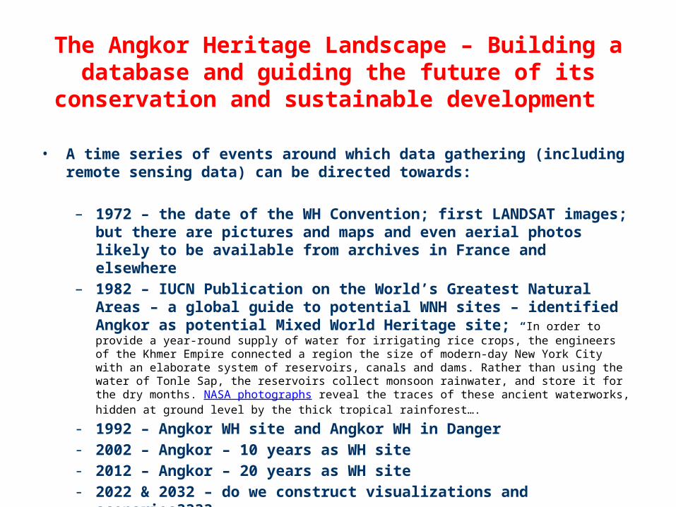
The Angkor Heritage Landscape – Building a database and guiding the future of its conservation and sustainable
development
• A time series of events around which data gathering (including remote sensing data) can be directed towards:
– 1972 – the date of the WH Convention; first LANDSAT images; but there are pictures and maps and even aerial photos likely to be available from archives in France and elsewhere
– 1982 – IUCN Publication on the World’s Greatest Natural Areas – a global guide to potential WNH sites – identified Angkor as potential Mixed World Heritage site; “In order to provide a year-round supply of water for irrigating rice crops, the engineers of the Khmer Empire connected a region the size of modern-day New York City with an elaborate system of reservoirs, canals and dams. Rather than using the water of Tonle Sap, the reservoirs collect monsoon rainwater, and store it for the dry months. NASA photographs reveal the traces of these ancient waterworks, hidden at ground level by the thick tropical rainforest….
- 1992 – Angkor WH site and Angkor WH in Danger- 2002 – Angkor – 10 years as WH site- 2012 – Angkor – 20 years as WH site- 2022 & 2032 – do we construct visualizations and scenarios????

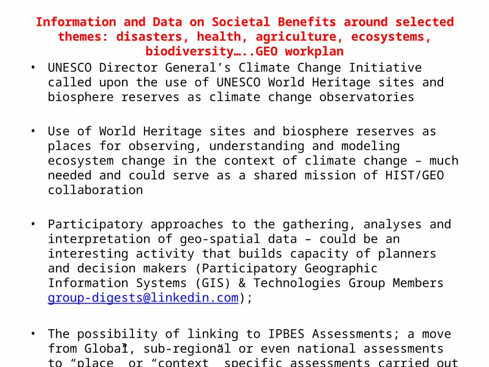
Information and Data on Societal Benefits around selected themes: disasters, health, agriculture, ecosystems, biodiversity…..GEO workplan
• Overlapping themes – Biodiversity and ecosystems: according to the CBD biodiversity has three (hierarchical) levels – ecosystems, species and gene pools; all societal benefits deriving from ecosystems are therefore also biodiversity benefits.
• CBD has strongly advocated an ecosystem approach to integrating terrestrial, freshwater and coastal/ocean resources for conservation and sustainable development; hence it is inevitable that in reality we would have to deal with land/seascapes that contain a mix of “natural” and human-impacted ecosystems. WH sites and BRs are good examples to “UN sites” to work with in order to demonstrate societal benefits of ecosystems and biodiversity themes;
• Tracking changes in ecosystems that characterize a land/seascape from the past and building scenarios on how that land/seascape could evolve in the future in the context of climate change consequences – an increasing need for planners and decision makers; and important heuristic tool for “capacity building;”
Information and Data on Societal Benefits around selected themes: disasters, health, agriculture, ecosystems, biodiversity…..GEO workplan
• UNESCO Director General’s Climate Change Initiative called upon the use of UNESCO World Heritage sites and biosphere reserves as climate change observatories
• Use of World Heritage sites and biosphere reserves as places for observing, understanding and modeling ecosystem change in the context of climate change – much needed and could serve as a shared mission of HIST/GEO collaboration
• Participatory approaches to the gathering, analyses and interpretation of geo-spatial data – could be an interesting activity that builds capacity of planners and decision makers (Participatory Geographic Information Systems (GIS) & Technologies Group Members [email protected]);
• The possibility of linking to IPBES Assessments; a move from Global, sub-regional or even national assessments to “place” or “context” specific assessments carried out not only by researchers but by a mix of researchers, planners and decision makers.
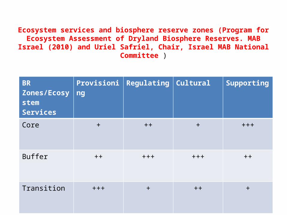
Ecosystem services and biosphere reserve zones (Program for Ecosystem Assessment of Dryland Biosphere Reserves. MAB Israel
(2010) and Uriel Safriel, Chair, Israel MAB National Committee )
BR Zones/Ecosystem Services
Provisioning Regulating Cultural Supporting
Core + ++ + +++
Buffer ++ +++ +++ ++
Transition +++ + ++ +

Thank you!