World Bank Document - Documents &...
49
PREPARATION OF ENVIRONMENTAL AND SOCIAL MANAGEMENT FRAMEWORK FOR THE SOUTH EAST DISASTER RISK MANAGEMENT (SEA DRM) PROJECT FOR CAMBODIA PRELIMINARY ENVIRONMENTAL AND SOCIAL ASSESSMENT DRAFT Prepared for: THE WORLD BANK GROUP 1818 H STREET NW WASHINGTON, DC, USA 20433 Prepared by: PROJECT MANAGEMENT UNIT MINISTRY OF RURAL DEVELOPMENT CORNER STREET 169 AND RUSSIA BLVD, 7 MAKARA PHNOM PENH, CAMBODIA JULY 2016 WB7708 VERSION 3 SFG2319 Public Disclosure Authorized Public Disclosure Authorized Public Disclosure Authorized Public Disclosure Authorized
-
Upload
vuongxuyen -
Category
Documents
-
view
217 -
download
0
Transcript of World Bank Document - Documents &...

PREPARATION OF ENVIRONMENTAL AND SOCIAL MANAGEMENT FRAMEWORK FOR
THE SOUTH EAST DISASTER RISK MANAGEMENT (SEA DRM) PROJECT FOR
CAMBODIA
PRELIMINARY ENVIRONMENTAL AND SOCIAL ASSESSMENT
DRAFT
Prepared for:
THE WORLD BANK GROUP 1818 H STREET NW
WASHINGTON, DC, USA 20433
Prepared by:
PROJECT MANAGEMENT UNIT
MINISTRY OF RURAL DEVELOPMENT
CORNER STREET 169 AND RUSSIA BLVD, 7 MAKARA
PHNOM PENH, CAMBODIA
JULY 2016
WB7708
VERSION 3
SFG2319
Pub
lic D
iscl
osur
e A
utho
rized
Pub
lic D
iscl
osur
e A
utho
rized
Pub
lic D
iscl
osur
e A
utho
rized
Pub
lic D
iscl
osur
e A
utho
rized

SEA DRM Project Preliminary Environmental and Social Assessment i
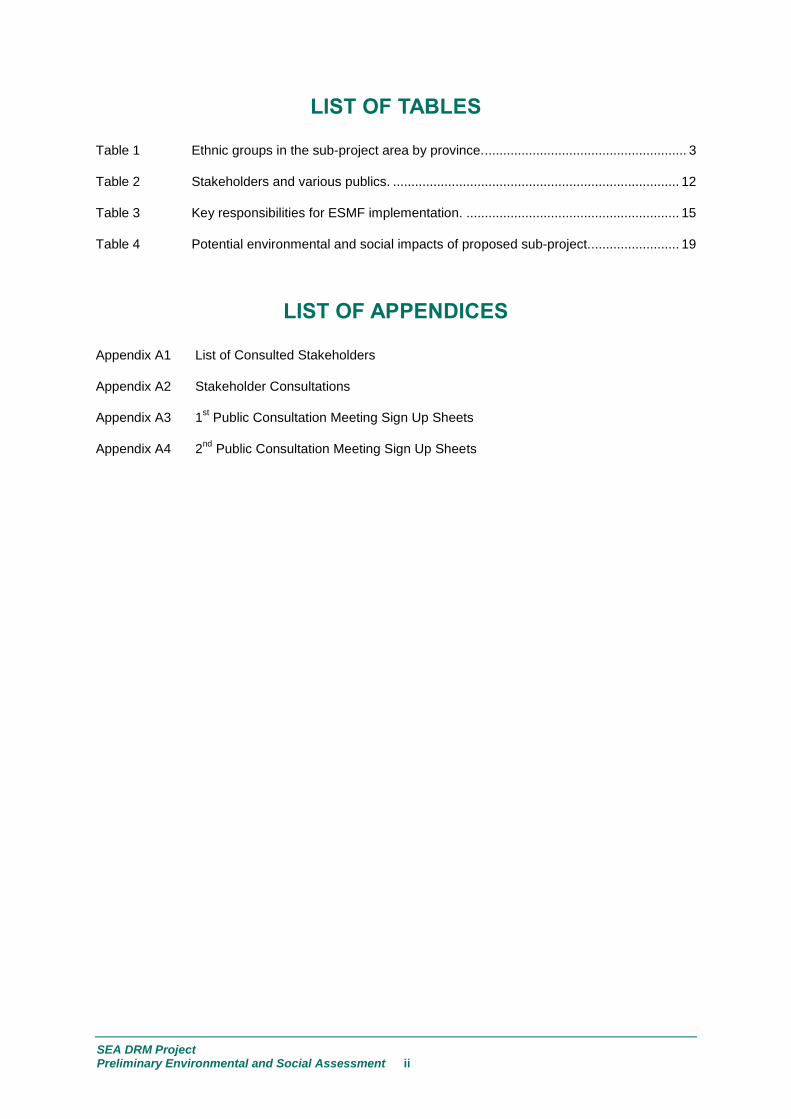
TABLE OF CONTENTS
LIST OF TABLES ............................................................................................. ii
LIST OF APPENDICES .................................................................................... ii
LIST OF ACRONYMS ...................................................................................... iii
INTRODUCTION ..................................................................................... 1 1.0
ENVIRONMENTAL AND SOCIAL BASELINE CONDITIONS ............... 2 2.0
STEUNG TRENG PROVINCE ....................................................................... 4 2.1
KRATIÉ PROVINCE ...................................................................................... 5 2.2
KAMPONG CHAM PROVINCE ..................................................................... 7 2.3
TBOUNG KHMUM PROVINCE ..................................................................... 8 2.4
SIEM REAP PROVINCE ................................................................................ 8 2.5
KANDAL PROVINCE .................................................................................... 9 2.6
ENVIRONMENTAL VULNERABILITIES AND RISKS ......................... 10 3.0
DAMAGE DUE TO FLOODS ....................................................................... 11 3.1
3.2 STANDARDS FOR CIVIL ENGINEERING ROADWORKS ......................... 11
KEY STAKEHOLDERS......................................................................... 12 4.0
INSTITUTIONAL ARRANGEMENTS AND CAPACITY ....................... 13 5.0
INSTITUTIONAL ARRANGEMENTS FOR PROJECT 5.1IMPLEMENTATION ..................................................................................... 13
INSTITUTIONAL STRENGTHENING ASSESSMENT ................................. 16 5.2
SITE-SPECIFIC POTENTIAL ENVIRONMENTAL AND SOCIAL 6.0IMPACTS, RISKS AND ISSUES ........................................................... 17
PARTICIPATORY SOCIAL ASSESSMENT GUIDELINES ................... 20 7.0
STAKEHOLDER CONSULTATIONS .................................................... 21 8.0
IMPORTANCE OF STAKEHOLDER CONSULTATIONS ............................ 21 8.1
SITE-SPECIFIC CONTEXTUAL GENDER INFORMATION ........................ 22 8.2
SEA DRM Project Preliminary Environmental and Social Assessment ii
LIST OF TABLES
Table 1 Ethnic groups in the sub-project area by province. ....................................................... 3
Table 2 Stakeholders and various publics. .............................................................................. 12
Table 3 Key responsibilities for ESMF implementation. .......................................................... 15
Table 4 Potential environmental and social impacts of proposed sub-project. ........................ 19
LIST OF APPENDICES
Appendix A1 List of Consulted Stakeholders
Appendix A2 Stakeholder Consultations
Appendix A3 1st Public Consultation Meeting Sign Up Sheets
Appendix A4 2nd
Public Consultation Meeting Sign Up Sheets
SEA DRM Project Preliminary Environmental and Social Assessment iii
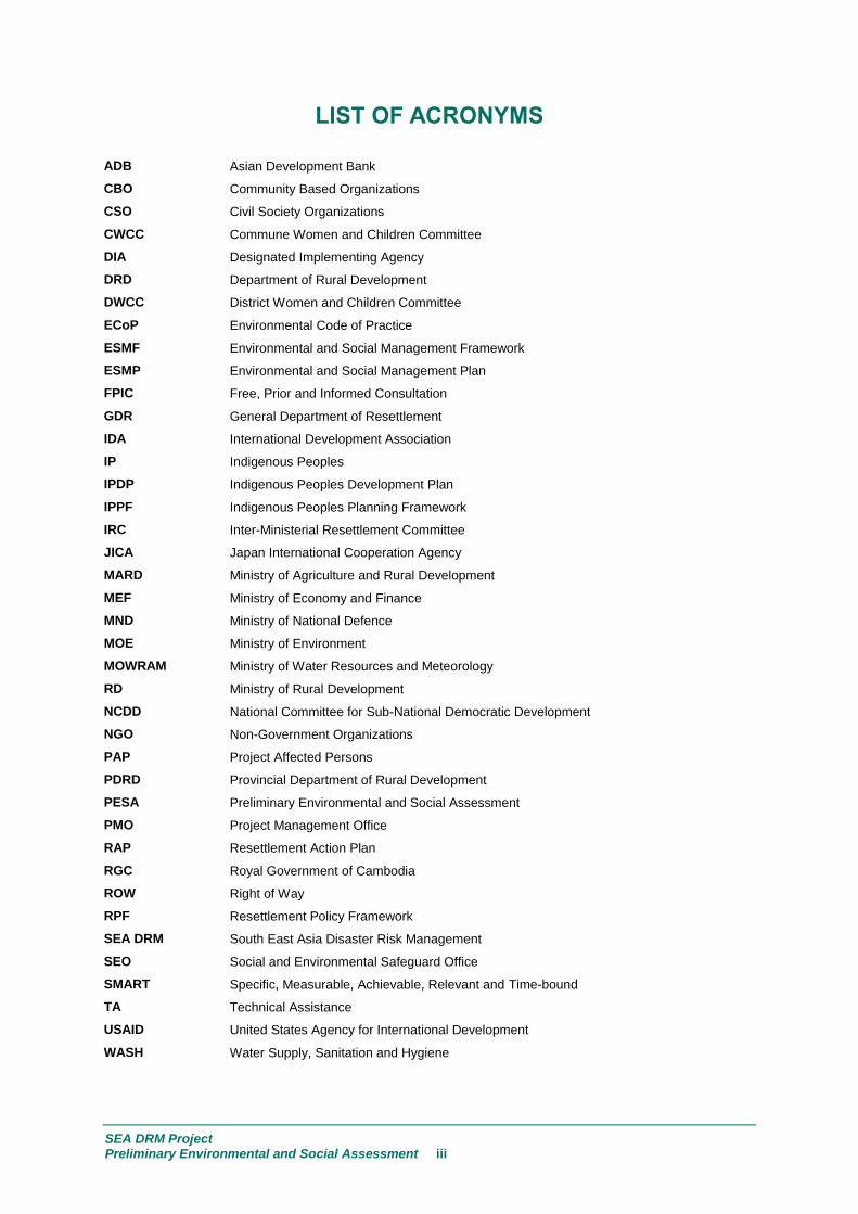
LIST OF ACRONYMS
ADB Asian Development Bank
CBO Community Based Organizations
CSO Civil Society Organizations
CWCC Commune Women and Children Committee
DIA Designated Implementing Agency
DRD Department of Rural Development
DWCC District Women and Children Committee
ECoP Environmental Code of Practice
ESMF Environmental and Social Management Framework
ESMP Environmental and Social Management Plan
FPIC Free, Prior and Informed Consultation
GDR General Department of Resettlement
IDA International Development Association
IP Indigenous Peoples
IPDP Indigenous Peoples Development Plan
IPPF Indigenous Peoples Planning Framework
IRC Inter-Ministerial Resettlement Committee
JICA Japan International Cooperation Agency
MARD Ministry of Agriculture and Rural Development
MEF Ministry of Economy and Finance
MND Ministry of National Defence
MOE Ministry of Environment
MOWRAM Ministry of Water Resources and Meteorology
RD Ministry of Rural Development
NCDD National Committee for Sub-National Democratic Development
NGO Non-Government Organizations
PAP Project Affected Persons
PDRD Provincial Department of Rural Development
PESA Preliminary Environmental and Social Assessment
PMO Project Management Office
RAP Resettlement Action Plan
RGC Royal Government of Cambodia
ROW Right of Way
RPF Resettlement Policy Framework
SEA DRM South East Asia Disaster Risk Management
SEO Social and Environmental Safeguard Office
SMART Specific, Measurable, Achievable, Relevant and Time-bound
TA Technical Assistance
USAID United States Agency for International Development
WASH Water Supply, Sanitation and Hygiene

SEA DRM Project Preliminary Environmental and Social Assessment 1
INTRODUCTION 1.0
The World Bank Group (the Bank) is considering funding the South East Asia Disaster Risk
Management (SEA DRM) Project (hereafter referred to as the “Project”) to be implemented in
Cambodia, Lao PDR and Myanmar. The Bank is proposing to fund the USD 60 million project through
an International Development Association (IDA) loan. Each of the SEA DRM Project borrower
countries are proposing a series of discrete sub-projects which will be assessed using several criteria
including a review of environmental and social safeguards policies and instruments that may be
triggered and technical, institutional, economic, and financial issues facing the proposed sub-projects.
The Project includes three components:
Component 1: Flood Risk Management Investments are intended to assist Cambodia, Lao PDR
and Myanmar governments to better prepare for and manage flood risks through investments in
rehabilitation of critical infrastructure and support for nonstructural investments for disaster and
climate resilience in each of the three SEA countries.
Component 2: Disaster Risk Assessment and Financing through support for comprehensive data
collection and knowledge management to support disaster risk management information systems in
aid of financial protection strategies and modelling.
Component 3: Contingent Emergency Response Component to support rapid response following
a Government-declared crisis or emergency.
For purposes of the present environmental and social management framework (ESMF), the main
emphasis is on the discussion of safeguards for high impact investments in rural access road
rehabilitation. Specifically, the focus will be on Component 1 – resilient rural infrastructure, including
civil engineering and roadworks, and capacity development for the Royal Government of Cambodia
(RGC) Ministry of Rural Development (MRD), which is the designated implementing agency (DIA).
There is a possibility that hydromet and meteorological forecasting services will be provided through
the Ministry of Water Resources and Meteorology (MOWRAM), with the use of grant funding.
The Resilient Rural Infrastructure component will focus on strengthening the resilience of rural road
corridors mainly through the strengthening of rural access roads and surrounding communities. By
enhancing the resilience of key rural access roads that link local communities to regional markets, the
project intends to deepen regional economic corridors and strengthen the competitiveness of rural
communities. Road strengthening will take place in six provinces along the Mekong and Tonlé Sap
basins, including Steung Treng, Kratié, Kampong Cham, Tboung Khmum, Siem Reap and Kandal.
High-impact investments will be selected using a set of criteria, including (i) the vulnerability of the
road to flooding; (ii) cost of roadworks; (iii) poverty reduction impact and number of beneficiaries; (iv)
importance of road for trade and market access; (v) importance of the road for access to safe areas
on higher ground, emergency evacuation and flood relief efforts. This will also help MRD to develop
its rural road asset inventory, which will be used to inform future investment decisions for upgrading
and operation and maintenance (O&M) in the future.
The Preliminary Environmental and Social Assessment (PESA) provides background information in
terms of the environmental and social context of the proposed sub-projects. The PESA provides
insight into environmental vulnerabilities and risks associated with natural disasters, potential
environmental and social impacts (i.e. positive and adverse effects), risks and issues. The PESA
provides information to guide decision-makers about alternative sub-projects, including design

SEA DRM Project Preliminary Environmental and Social Assessment 2
features and/or mitigation measures. The PESA provides guidance on culturally-appropriate and
participative consultation methods for engaging with different populations (i.e., ethnic minorities and
vulnerable groups – women and female/male youth and children, men, the elderly and disabled, etc.).
The PESA also documents findings of the consultation, engagement and information disclosure
process with national and local government officials, stakeholder community (i.e., civil society
organizations including non-government organizations, community-based organizations), various
publics and different populations.
The PESA provides the contextual and, where possible, the factual basis for guiding and informing
development of the subsequent Environmental and Social Management Framework (ESMF) with its
accompanying safeguards instruments (i.e. Indigenous Peoples Planning Framework [IPPF] and
Resettlement Policy Framework [RPF]) and measures, including an Environmental Management Plan
(EMP), Abbreviated Resettlement Action Plan (ARAP) or Resettlement Action Plan (RAP), and
Indigenous Peoples Development Plan (IPDP), among others.
ENVIRONMENTAL AND SOCIAL BASELINE 2.0CONDITIONS
The Cambodian road network covers about 35,500 km, including approximately 4,000 km of national
roads, 3,500 km of provincial roads, and 28,000 km of rural and strategic roads (ADB, 2002). The roads
have a significant number of bridges, about 4,000 on the primary roads alone. Years of war have left the
Cambodian road network in a very poor state, and large floods in 1996, 2000 and 2013 caused
extensive damage. A road condition survey in 2002 revealed that 28% of the network was in good or fair
condition, 35% in poor condition, 28% in bad condition, and 6% under reconstruction or rehabilitation
(ADB, 2002).
Most of the road construction activities in Cambodia are geared towards rehabilitation of the existing
road network, including repair or replacement of existing bridges. Spatial planning and improved
alignment has not been a priority and little attention was paid to improved management of hydrology
and hydraulics of the floodplain. In 2006 a masterplan for road development was prepared (JICA,
2006). The masterplan does not focus on the interaction between roads and floods or possible
impacts of roads on the floodplain system.
Rehabilitating and strengthening the resilience of rural infrastructure is considered a priority
investment. The Ministry of Economy and Finance (MEF) have advised that infrastructure investments
under the SEA DRM and, in particular, the Cambodia SEA DRM Project should focus on the
rehabilitation of rural roads. Consequently, the RGC has requested assistance from the World Bank to
fund the repair and rehabilitation of vital road segments in provinces along the Mekong and Tonlé Sap
to withstand regular flood events. Such rehabilitation of roadworks could help reduce recurring repair
and reconstruction costs.
While the type of proposed sub-project investments is known (i.e. rehabilitation of secondary
provincial rural roads), the specific locations and engineering designs are not known, therefore a
framework approach will be used. The South East Asia Disaster Risk Management (SEA DRM)
Program was given a safeguards Category “A” (OP 4.01), largely because the specific scope and
scale of the investments were unknown, and because Myanmar is one of the three countries.
Although site-specific locations for the proposed Cambodia SEA DRM sub-projects are unknown, the
SEA DRM Project Preliminary Environmental and Social Assessment 3
nature of the investments is now known and they are unlikely to have any significant environmental
and social impacts, and would be better suited to a Category “B” classification.1
The following province-by-province sections provide a glimpse of the environmental and socio-cultural
conditions in each of the six provinces where the MRD have proposed to rehabilitate rural roads.
Each province has its own rich and diverse ethno-cultural characteristics which have guided its
development. In terms of the presence of indigenous people (IP), the diversity of its ethnic groups is
no different. It is difficult to provide reliable demographic and ethnographic information on province-
by-province IP due to its recent history of genocide, war, massive migration, and forced resettlement.
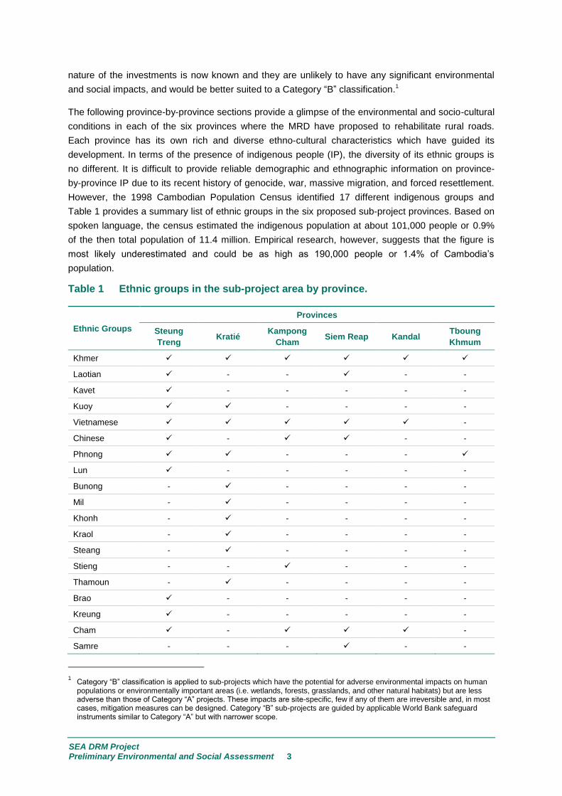
However, the 1998 Cambodian Population Census identified 17 different indigenous groups and
Table 1 provides a summary list of ethnic groups in the six proposed sub-project provinces. Based on
spoken language, the census estimated the indigenous population at about 101,000 people or 0.9%
of the then total population of 11.4 million. Empirical research, however, suggests that the figure is
most likely underestimated and could be as high as 190,000 people or 1.4% of Cambodia’s
population.
Table 1 Ethnic groups in the sub-project area by province.
Ethnic Groups
Provinces
Steung
Treng Kratié
Kampong
Cham Siem Reap Kandal
Tboung
Khmum
Khmer
Laotian - - - -
Kavet - - - - -
Kuoy - - - -
Vietnamese -
Chinese - - -
Phnong - - -
Lun - - - - -
Bunong - - - - -
Mil - - - - -
Khonh - - - - -
Kraol - - - - -
Steang - - - - -
Stieng - - - - -
Thamoun - - - - -
Brao - - - - -
Kreung - - - - -
Cham - -
Samre - - - - -
1 Category “B” classification is applied to sub-projects which have the potential for adverse environmental impacts on human
populations or environmentally important areas (i.e. wetlands, forests, grasslands, and other natural habitats) but are less adverse than those of Category “A” projects. These impacts are site-specific, few if any of them are irreversible and, in most cases, mitigation measures can be designed. Category “B” sub-projects are guided by applicable World Bank safeguard instruments similar to Category “A” but with narrower scope.

SEA DRM Project Preliminary Environmental and Social Assessment 4
Error! Reference source not found. (Cont’d.)
Ethnic Groups
Provinces
Steung
Treng Kratié
Kampong
Cham Siem Reap Kandal
Tboung
Khmum
Tum Puon - - - - -
Kachock - - - - -
Jarai - - - - -
Thai - - - - -
The section below provides province-by-province background information related to the environmental
and social context for the proposed sub-projects located in six provinces of Cambodia. At time of
writing, the MRD provided a long list of over seventy proposed sub-projects in six provinces. However,
the Cambodia SEA DRM Project will only be able to rehabilitate a few of the proposed sub-projects in
each province and without specific locations identified for roadworks rehabilitation, it is only possible
to provide generalized contextual information on a province-by-province basis.
STEUNG TRENG PROVINCE 2.1
Environment - Steung Treng is a north-eastern province of Cambodia. It shares borders with
Ratanakiri to the east, Preah Vihear to the west, and Kratié and Kampong Thom to the south and Lao
PDR to the north. It encompasses an area of 12,061 square kilometers (km2) with coordinates 1331’
N and 10557’ E. The province is subdivided into five districts, including one municipality, comprising
4 quarters, 30 communes and 128 villages. The five districts are Sesan, Siem Bouk, Siem Pang,
Thala Barivat, and Stung Treng. The provincial capital is Steung Treng, which is located to the west
and close to the joining of the Mekong and Se Kong rivers. Steung Treng province is characterized by
its extensive forests, scattered islands, plateaus and mountainous areas. Most significantly, the
province is positioned at the intersection of four rivers: the Mekong, Se Kong, Se San, and Srea Pok.
The rivers, characterized by deep pools, rocky beds and sandy islands create a rich aquatic habitat
that serves as spawning and breeding grounds for a diversity of fish species and other animals.
Steung Treng’s land can be divided into five categories, some of which may overlap: forest lands
(928,000 hectares [ha]), agricultural lands (126,8336 ha), residential lands (103,217 ha), roads (2,400
ha), river, streams, and canals (41,094 ha), and fallow lands (13,200 ha)2. There are several
protected areas found in Steung Treng, including a 37 kilometer stretch of the Mekong River (5 km
north of Steung Treng city and 3 km south of Lao PDR) and an area of 14,600 ha as part of a Ramsar
Site 3. Approximately 13,000 people are living at the Ramsar site. Another important protected area in
the province is Virachey Natural Park (332,500 ha) which crosses into Ratanakiri province.
Climate and Extreme Weather - Steung Treng’s climate is governed by monsoons. The annual
temperatures range from 17 to 39 Celsius (C). The province’s climate can be divided into three
seasons: cool season (November - March), hot season (March - May), and rainy season (May -
October). Rainfall can range from 1,800 millimeters (mm) to 2,042 mm per year. Both flooding,
especially flash flooding, and drought are chronic events in Steung Treng. Although flooding is
2 http://www.mrcmekong.org/assets/Publications/Consultations/SEA-Hydropower/10.Cambodia-Baseline-Assessment-
Perspective28Jan.pdf 3 http://www.ramsar.org/sites-countries/the-ramsar-sites

SEA DRM Project Preliminary Environmental and Social Assessment 5
relatively minor compared to other provinces, these events adversely impact the livelihoods of the
people, especially in relation to their crop production, loss of livestock, health and infrastructure.
Damage and reparation costs due to floods in 2000 to 2002 ranged from 817,400 USD to 337,240
USD4.
Social - The total population of Steung Treng province is 111,734 people, constituting 0.7% of
Cambodia’s population. The population has a low population density of 10 people per square
kilometer (ppl/km2) and is divided between 50.5% female and 49.5% male. As the population density
is low and the province is endowed with natural resources, the immigration rate is very high. Almost
twenty percent (19.4%) of the province's current population has migrated from outside the province.
Fourteen (14) ethnic groups are currently living in the province. These ethnic groups include: Khmer
(64,271 people), Laotian (4,928 people), Kavet (2,064 people), Kuoy (1,588 people), Vietnamese (674
people), Chinese (458 people), Phnong (284 people), Lun (359 people), Brao (345 people), Kreung
(210 people), Chams (85 people), Tum Puon (18 people), Kachock (14 people), and Jarai (5 people).
Despite the appreciable ethnic diversity, livelihood strategies are comparatively similar. Livelihood
strategies include rice farming, fishing, animal husbandry, and gathering non-timber forest products
(NTFPs). A majority (85%) of the population, live in rural areas of the province, and depend on
agricultural farming for their livelihoods. Steung Treng is one of the poorer provinces in Cambodia with
flooding, drought and over-extraction of natural resources. The province’s economy is largely based
on the agricultural sector. Plantations such as rubber, timber and cashew nuts are located across the
province. Other key industries in the province include livestock rearing, fishing and sericulture.
Developing the tourism sector, efficient infrastructure, road accessibility, and trade will give rise to
opportunities for economic growth and poverty reduction.
As discussed in Annex 2, a number of issues and concerns were relayed during community
consultation in relation to the environment, natural resources conservation and degradation of land
which may occur as a result of sub-project implementation
KRATIÉ PROVINCE 2.2
Environment - Kratié is a province located in the northeast of Cambodia. The province encompasses
an area of 11,094 km2 with coordinates of 1229’ N and 1061’ E. Kratié borders the provinces of
Stung Treng to the north, Mondulkiri to the east, Kampong Thom and Kampong Cham to the west,
and Tboung Khmum and Viet Nam to the south. The province is subdivided into five districts and one
city, Chhloung, Preaek Prasab, Sambour, Snuol, Chitr Borie, and Krong Kratié. The provincial capital
is Kratié, located in Kratié District. The Mekong River bisects the province from north to south
resulting in narrow floodplains. Most of the province is covered in dense forests, though some are
more open and generally consist of deciduous trees that lose their leaves during the dry season. The
province also consists of undulating uplands and lowlands. Land use patterns in the upland area of
Kratié province consists of forest, grazing, shrub and farming land. Due to economic development
pressures, the use and control of the forests have significantly altered. Forest lands have been
converted into plantations and rice paddies by farmers. Agriculture in Kratié, while not as abundant as
in other provinces, continues to grow and produces maize, cassava, sesame, sweet potato,
sugarcane, soya beans, and more5. There are two protected areas in Kratié province: Keo Seima
4 https://portals.iucn.org/library/efiles/documents/2006-016.pdf
5 http://pdf.usaid.gov/pdf_docs/Pnadn800.pdf

SEA DRM Project Preliminary Environmental and Social Assessment 6
Wildlife Sanctuary and Snoul Wildlife Sanctuary. The Keo Seima Wildlife Sanctuary encompasses
over 298,160 ha, although more than half is within Mondulkiri province. Adjacent to the Keo Seima
Wildlife Sanctuary is the Snoul Wildlife Sanctuary. The Snoul Wildlife Sanctuary in Kratié
encompasses 61,943 ha. In 2008, a 55 kilometer stretch of the Mekong River in Kratié and Stung
Treng provinces, was proposed as a “special management site” due to its high biodiversity value.
Most recently, in April 2016, the Cambodian government proposed to register five new protected
forests, amounting to a total of about 950,000 ha. One of the protected areas would include the Prey
Long forest residing in Kratié, Kompong Thom, and Stung Treng provinces.
Climate and Extreme Weather - Kratié province follows a monsoonal climate, with a cool season
from November to March, a hot season from March to May, and a rainy season from May to October.
Temperatures may range from 22 Celsius (C) to 36 C annually. The province’s climate has three
seasons: a cool season from November to March (22 - 28C), a hot season from March to May (28 -
36C), and a rainy season from May to October (24 - 32C, with humidity up to 90%). The annual
flow of the Mekong River in Kratié province from 1985 to 2009 has been determined to be 401 cubic
kilometers (km3)6. The Mekong River may overflow its riverbanks by as much as 4 meters (m) during
the rainy season, resulting in frequent and prolonged flooding. The peak of the flood is during
September where the monthly discharge averages in excess of 36,000 cumecs (cubic metres per
second)7. High flood years in Kratié include 1961, 1978, and 2000. However, the Mekong floods at
Kratié have been declining for the past two decades, and in 2012, flood volumes were almost 40%
below the normal rate. Kratié is increasingly experiencing severe drought, which has affected rice
production and other agricultural crops. Notable drought years have included 1977, 2004, and 2008.
Social - The population of Kratié province is 318,523 people; accounting for 2.4% of the total
population of Cambodia. The province’s population is split between 50.3% female and 49.7% male8.
Approximately 70% of residents live along the Mekong River and the remaining 30% live in
mountainous areas. The majority of the population are Khmer, the largest ethnic group in Cambodia.
There is a significant Vietnamese minority living in Kratié. An estimated 8% of the province’s
population is comprised of indigenous people (IP). The indigenous ethnic minorities constitute seven
groups: Bunong, Kouy, Mil, Khonh, Kraol, Steang, and Thamoun. The largest indigenous ethnic group
is the Steang accounting for a population of 6,541 people, while the Khonh minority ethnic group has
a population of 743 people. The Kraol ethnic group represents 4,202 people, the Mil ethnic group
1,697 people, and Thamoun ethnic group 865 people, respectively9. The majority of Kratié’s residents
are subsistent farmers or fishers. Around three-quarters (78%) of the population are engaged in
agriculture, both for livestock (i.e., poultry, swine and cattle) and crop production. Crops include
cassava, maize, sesame, sweet potato, sugarcane, soya beans, and more10. Tobacco is one of the
major products of Kratié, representing almost twenty percent (18%) of Cambodia’s crop. Around
20,000 ha are dedicated to rubber plantations where the latex is exported to countries such as Viet
Nam, Japan, and Korea. Kratié’s proximity to both Phnom Penh and Viet Nam provides efficient
access and opportunities for trade between both growth poles. Other key industries include a growing
6 http://www.mrcmekong.org/assets/Publications/basin-reports/Annual-Mekong-Flood-Report-2012.pdf
7 http://www.mrcmekong.org/assets/Publications/report-management-develop/MRC-IM-No2-the-flow-of-the-mekong.pdf
8 https://www.statsmonkey.com/sunburst/37217-total-population-statistics-of-Kratié-by-gender-cambodia-stats.php
9 http://www.unesco.org/new/fileadmin/MULTIMEDIA/FIELD/Phnom_Penh/pdf/ethnolinguistic_groups_of_cambodia_poster.pdf
10 http://pdf.usaid.gov/pdf_docs/Pnadn800.pdf

SEA DRM Project Preliminary Environmental and Social Assessment 7
tourism sector and natural attractions, contributing over USD 3 million per year. There is potential for
hydro-electric power and mineral resources.
As discussed in Annex 2, Kratié province has indigenous people (IP) located within proximity of the
proposed sub-projects. Special attention must be given to IP in relation to their traditional land and
forest which may be affected due to project development. IP expressed concerns about forest land
encroachment after the project implementation as well as impact on their belief systems and
traditional practice, and decision making.
KAMPONG CHAM PROVINCE 2.3
Environment - Kampong Cham is located in the central lowlands of Cambodia and is bordered by
Kratié to the north-east, Prey Veng to the south, Kampong Chhnang to the west and Kampong Thom
to the northwest as well as Viet Nam to the east. The province covers an area of 4,549 km2 with
coordinates 1159’ N and 10527’ E. Kampong Cham is subdivided into 10 districts: Batheay,
Chamkar Leu, Cheung Prey, Kampong Siem, Kang Meas, Kaoh Soutin, Prey Chhor, Srei Santhor,
Stueng Trang, and Krong Kampong Cham, with Kampong Cham serving as the provincial capital. The
majority of the province consists of lowlands with the Mekong River flowing through the province.
Agriculture and industrial crops consist of 413,035 ha of land, while forest area represents 300,000
ha, flooded land 312,860 ha, plain land 270,000 ha, and red soil 97,000 ha 11. There are currently no
protected areas in Kampong Cham province.
Climate and Extreme Weather - Kampong Cham’s climate is governed by monsoons. The average
temperature is around 27 C with a minimum temperature of about 16 C. December and January are
the coolest months during the year. The province’s three seasons are: the cool season from
November to March (17-27C), hot season from March to May (28 - 36C), rainy season from May
to October (25 - 35C, with humidity up to 90%). Kampong Cham is regularly hit by flash flooding and
has endured severe flooding and drought incidents in the recent past. Overall, the province suffers
more from droughts than floods. However, in 2014, Kampong Cham suffered the second highest
death rate in Cambodia because of flooding that began in July and lasted until the end of August. In
June 2016, the province experienced increasing water shortages that had not been seen since
198312. Landslides are also a common occurrence in Kampong Cham and have contributed to
infrastructure damage, especially roads.
Social - Kampong Cham’s total population is currently 928,694 people although, before it was split
into two provinces (Kampong Cham and Tboung Khmum) it’s population was 1,679,922 people,
comprised of 818,662 males and 861,330 females. Much like the majority of Cambodia, Kampong
Cham’s major ethnic group are Khmer as well as ethnic minorities such as Vietnamese, Chinese, and
Cham groups. Kampong Cham’s strategic location, open policies and trading activities has
transformed the province into the transportation hub for Cambodia, Thailand and Viet Nam.
Transportation access to the province includes a comprehensive road network, railway, and river
boats. Kampong Cham’s poverty headcount index is 37.2%13,
placing it above Cambodia’s poverty
rate. Generally, people make their living from rubber and cashew nut plantations, fishing, and farming.
Potential investment opportunities include more value adding agro-industry, such as rice plantation,
11
http://www.cambodiainvestment.gov.kh/kampong-cham-province.html
12 http://www.phnompenhpost.com/national/drought-highlights-intl-water-day
13 Poverty Profile 2004 EN.pdf
SEA DRM Project Preliminary Environmental and Social Assessment 8
cassava (tapioca), sugar cane, durian, and palm fruit. There is also potential for tourism because of
the province’s accessibility and historical, cultural attractions, as well as natural scenery.
TBOUNG KHMUM PROVINCE 2.4
Situation - Tboung Khmum is located on the central lowlands of the Mekong River. The province
covers an area of 4,928 km2 with coordinates of 1159’ N and 10527’ E. Tboung Khmum borders
Kampong Cham province to the west, Kratié province to the north, Prey Veng province to the south,
and Viet Nam to the east. The province is divided into six districts and one city, Dambae, Krouch
Chhmar, Memot, Ou Reang Ov, Ponhea Kraek, Tboung Khmum, Krong Suong and its capital and
largest city, Suong. Tboung Khmum used to be part of Kampong Cham province, until December 31st,
2013 when a Royal Decree was signed by King Norodom Sihamoni to split the province in two. Due to
the province’s recent establishment, very little provincially aggregated data is available.
As discussed in Annex 2 during the community consultations, the main social issues concerned were
that of acquisition of land occupation and its impact on different populations. Land acquisition could
be on a temporary or permanent basis as a result of the road rehabilitation. However, it can be
resolved through a clear mechanism of land donation or other land acquisition guidelines.
Environmental impacts refer to the engineering environmental design such as borrow pit of soil
excavation for the project (see Annex 2).
SIEM REAP PROVINCE 2.5
Environment - Siem Reap is located in the northwest of Lao PDR and borders the provinces of
Oddar Meanchey to the north, Preah Vihear and Kampong Thom to the east, Battambang to the
south, and Banteay Meanchey to the west. Siem Reap is 10,299 km2 in area, making it the 10th
largest province in Cambodia, with coordinates of 1321’ N and 10351’ E. The province is divided
into 12 districts, 100 communes, and 907 villages. The districts are Angkor Chum, Angkor Thum,
Banteay Srei, Chi Kraeng, Krahlanh, Puok, Prasat Bakong, Soutr Nikom, Srei Snam, Svay Leu, Varin
and Siem Reap, with Siem Reap being the provincial capital. The province, in general, consists of
typical plain wetland areas, rice fields and other agricultural plantations, especially in the south. The
north is comprised of undulating area covered with forests. Rising from Phnom Kulen, the Siem Reap
river meanders through the northern part of Siem Reap Province and eventually flows into the Tonlé
Sap Lake. The total agricultural land is 216,178 ha, and forestry area consists of 476,824 ha,
accounting for 45.2% of the total area of Siem Reap. Wildlife sanctuaries and protected areas include
the following: Angkor Scenery Protected area (10,800 ha), Beung Pe Wildlife Sanctuary (245,500 ha),
Kulen Prom Tep Wildlife Sanctuary (402,500 ha), and Kulen National Park (37,500 ha).
Climate and Extreme Weather - Siem Reap’s climate is controlled by the monsoons. In general, the
hottest month is April, the coolest month is December, the wettest month is September, and the driest
month is January. The rainy season ranges from May to October, whereas dry periods include the
months of January, February and December. The annual average temperature is 27.1C, with the
coldest temperature being 26C and the warmest temperature being 31C. Approximately 1,310 mm
of precipitation falls annually. Siem Reap is also exposed to flooding and increasingly frequent and
prolonged droughts. Specifically, from 2009 to 2012, during October and November, heavy rain (up to

SEA DRM Project Preliminary Environmental and Social Assessment 9
140 mm per day) caused flash flooding, resulting in significant damage to agriculture and
infrastructure in Siem Reap14.
Social - Siem Reap has a total population of 896,309 people, accounting for 6.7% of the total
Cambodian population. The province is roughly split between 51.1% female and 48.9% male15
. The
majority of the province’s population (95%), are Khmer interspersed with Vietnamese, Chinese, Cham
minorities and several other ethno-linguistic minority groups found in the hill tribes in the northeast.
Tourism is the principle income of Siem Reap. An estimated 50% of jobs in Siem Reap are related to
the growing tourism industry, significantly affecting the livelihoods of the population. Despite tourism
providing jobs and opportunities, incomes are consistently low and Siem Reap is one of the three
poorest provinces in Cambodia, with 47% of the population living below the provincial poverty line16
.
There are high costs to enter the tourism industry due to insufficient financial resources or education
levels. Contributing factors to the poverty are poor soil fertility, small agricultural landholdings, and
lack of technological or methodological knowledge for animal raising and vegetable cultivation.
However, opportunities are open in the province’s other key industries, which include handicrafts,
food processing, and more recently, construction.
KANDAL PROVINCE 2.6
Environment - Kandal is one of the smaller provinces of Cambodia. This province completely
surrounds the Cambodian capital Phnom Penh, but does not include it. Kandal’s capital is Ta Khmau
and is around 20 km south of Phnom Penh. The province encompasses an area 3,568 km2 with
coordinates of 1122’ N and 10512’ E. Kandal is located in the middle-south of the country and is
bordered by Kampong Chhnang and Kampong Cham to the north, Prey Veng to the east, Kampong
Speu and Takeo to the west as well as Viet Nam to the south. The province is divided into 11 districts,
146 communes, and 1,087 villages. The districts are Kandal Stueng, Kien Svay, Khsach Kandal,
Kaoh Thum, Leuk Daek, Lvea Aem, Mukh Kamphul, Angk Snuol, Phpnhea Lueu, S’ang, and Ta
Khmau. The province consists of the typical plain wet area of Cambodia, covered in rice fields and
other agricultural plantations. The average altitude of the province is less than 10 m above sea level.
The province also features two of the biggest rivers in the country: The Tonlé Bassac and the
Mekong, allowing for rich and accessible water resources. Freshwater fish yields 79,473 tons per
year. Agricultural land, mostly consisting of rice, covers 175,737 ha. There are currently no protected
areas in Kandal province.
Climate and Extreme Weather - Kandal has a monsoon climate which is divided into three seasons:
the cool season from November to March (22 - 28C), the hot season from March to May (28 -
36C), and the rainy season from May to October (24 - 32C, with humidity up to 90%). Rainfall
averages 1,686 mm per year. The highest recorded depth of flood inundation in this province was 3.1
m in agricultural fields. Kandal is subject to annual flash flooding, which has caused significant
damage to infrastructure and agriculture in 2011 and 2012. In September 2002, Kandal experienced
simultaneous floods and drought and was one of the worst hit provinces. Floods and drought levels
14
http://www.mrcmekong.org/assets/Publications/basin-reports/Annual-Mekong-Flood-Report-2012.pdf
15 https://knoema.com/CBDGS2008/demographics-statistics-of-cambodia-2008?region=1000170-siemreap
16 http://www-wds.worldbank.org/external/default/WDSContentServer/WDSP/IB/2010/08/12/000356161_20100812014703/Rendered/PDF/E25190v10P09701ronmental0Assessment.pdf

SEA DRM Project Preliminary Environmental and Social Assessment 10
vary within Kandal. For example, Lvea Em, a district of Kandal, is flooded for six months every year so
the population has resorted to building their houses on stilts17.
Social - The current population in this province is 1,280,781 people, comprising of 9% of the country's
total population. The province is divided between 621,948 males and 658,833 females. The
population density of Kandal is 359 people per km2. The ethnic majority group found in the province
are Khmer interspersed with ethnic minorities. Kandal’s location, bordering Viet Nam as well as easy
access to Phnom Penh, permits for many business and commerce opportunities, resulting in a higher
per capita consumption than the national average. Almost two-thirds (60%) of workers live in the
province capital, Ta Khmau, and commute to Phnom Penh for work. The garment and footwear
industries, which employ more than 500,000 workers, are major industries in Kandal. However, due to
fertile soils and abundant water resources, farming and fishing also contribute to the province’s
income.
ENVIRONMENTAL VULNERABILITIES AND RISKS 3.0
Approximately 80 percent of Cambodia’s territory lies within the Mekong River and Tonlé Sap basins,
known to have large fluctuations of water levels between the dry and wet seasons. Around 30 tropical
storms affected Cambodia between 1999 and 2013 with severity increasing in recent years. Floods
cause widespread disruption and dislocation on a temporary basis (i.e. until waters recede) on a
medium- to long-term basis. The 2013 floods affected more than 1.8 million people in 20 provinces.
Flooding causes major disruption to affected people who have to adjust to the associated shocks and
stresses which impact their livelihoods, assets and well-being. Loss of connectivity for short- or longer
periods can have a devastating effect on public infrastructure and commerce. Extreme weather
events caused by climate change are expected to increase in intensity, severity, and frequency with a
consequent effect on livelihoods and well-being.
Floods can severely damage infrastructure including roads. However, roads and associated
infrastructure (i.e., bridges, culverts, etc.) also impact flood events. They fragment the floodplains and
interrupt natural flow of water, sediments, nutrients and aquatic life. Road development in floodplains
usually alters floodplain hydraulics and impacts related aquatic ecosystems. Roads in floodplains are
often built on dikes, which can have both intended and unintended impacts. Beneficial impacts
including acting as a ‘reservoir dam’ or tank to store water for irrigation in the dry season. Roads can
act as a dam to protect spring crops from the early stages of the flood. Floods can also damage roads
with negative effects on transportation. This can hamper economic development, and also slow
emergency relief actions.
Mekong floods perform an important ecological function, (an example or two would help here) which is
essential for much of the population. However, flooding also results in economic and financial costs,
including; damage to infrastructure and houses; lost lives and damage to property and assets (i.e.
crops and trees).
During the community consultations, community members expressed concerns to the Consultant
regarding insufficient water for livestock, homestead gardens and potable water for household
consumption. These kinds of water shortages are perennial in nature during the dry season. However,
17
file:///Users/sabinebailey/Downloads/a_survey_of_rural_cambodian_households%20vulnerability%20and%20adaptation%20march%2005.pdf

SEA DRM Project Preliminary Environmental and Social Assessment 11
drought concerns could be mitigated somewhat as an indirect result of the proposed sub-project road
rehabilitation work. For instance, conversion of soil borrow pits into environmentally-friendly
community water retention ponds or, possibly, a channel for water flow to drain water during the wet
season could be considered.
There are both direct and indirect effects of roads on the environment. Direct effects are easily seen
and are easier to comprehend. In contrast, many indirect environmental effects of roads are
cumulative and involve changes in community structures and ecological processes that may not be
well understood. Roads act as dams, altering water flow from one side to the other. This can result in
flooding on one side of the road and drying out on the other, altering vegetation and associated
ecosystems. Roads also can cause changes to hydrologic flows (i.e., drainage patterns).
The challenge is to take the above considerations into account during road planning and design. The
MRD is one of the ministries responsible for secondary road networks and which considers an
integrated approach to planning road networks.
DAMAGE DUE TO FLOODS 3.1
Cambodian government policy is to protect its population from floods as much as possible by;
implementing flood warning systems, protecting cities like Phnom Penh with dikes, building small
levees to protect agricultural fields, and constructing canals to direct flood waters. Local populations
have learnt over time to adapt to the constraints that floods impose and to take advantage of their
benefits, including living in houses built on stilts, transporting people and goods in boats, adjusting
their agricultural pattern to the annual flood pulse, and developing seasonal fishing practices (e.g.
MARD, 2003).
As a result of this cultural adaptation, floods do not cause much damage to traditional settlements,
and actually bring many benefits. However, extra-ordinary floods cause loss of human lives and
substantial damage to crops, assets and infrastructure. The flood in 2000 was an exceptional flood
causing more than 300 casualties and a total damage of over USD 150 million, including damage to
infrastructure of around USD 100 million.
3.2 STANDARDS FOR CIVIL ENGINEERING ROADWORKS
Road planning and design in Cambodia are based on international guidelines for roads located
outside the floodplain, with the exception of guidelines for rural access roads which are largely the
purview of the MRD. The country has limited national standards and guidelines. Cambodia has
insufficient funds to internally finance necessary road rehabilitation and construction programs. Many
of the rehabilitation and construction works are financed by donor organizations including; Asian
Development Bank (ADB), World Bank, or countries like Japan and China. Donors generally do not
finance all rehabilitation and construction activities and the work is often done “piecemeal” depending
on available funding. Donors often have preferred companies and their own rules for contractors
involved in civil engineering and roadworks. Contractors tend to use different guidelines and
standards due to the lack of national guidelines. Consequently rehabilitation activities often result in a
patchwork of different road sections constructed under different guidelines to different design
standards. This project could help harmonize different standards and guidelines related to road
construction and rehabilitation.

SEA DRM Project Preliminary Environmental and Social Assessment 12
In Cambodia, current road planning and design practices consider hydraulics from the perspective of
road-bed stability and minimizing damage during floods. The impact roads have on floodplain
dynamics or the ecology of floodplains (i.e. beyond the immediate vicinity of the road) is usually not
considered. The MRD guidelines for rural roads are an exception as they include to some extent
floodplain dynamics.
KEY STAKEHOLDERS 4.0
The RGC supports the Cambodia SEA DRM Project and supports actions to improve participation,
public consultation and information disclosure. Implementation relies on strategies, legislation and
procedures that are in place in Cambodia and will be supplemented - as necessary - with World Bank
safeguards policies for participation, consultation and disclosure concerning the safeguards aspects
of the Cambodia SEA DRM Project as described in the ESMF, including procedures narrated in the
IPPF and RPF.
The Cambodia SEA DRM Project will pursue a process of meaningful consultation and engagement
that includes national and local government, and relevant stakeholders. The Cambodia SEA DRM
Project supports consultative decision making by ensuring public access to information on
environmental and social aspects of the Cambodia SEA DRM Project. In addition to free, prior and
informed consultation (FPIC) related to potential environmental and social impacts (i.e. positive or
adverse effects), the consultation process should inform and explain the proposed sub-project(s) to
affected communities, gather information from impacted populations, and conduct gender sensitive
awareness raising.
Table 2 lists national and local government bodies, key stakeholders, various public entities and
different populations who may be involved directly or indirectly in the Cambodia SEA DRM Project.
Table 2 Stakeholders and various publics.
Sl.
No. Entity Key Stakeholder
1 Government and
regulatory agencies MRD, MEF/GDR, MOE, MOWRAM, PDRD, and Districts
2 Private sector
companies
Private sector companies with the technical expertise and capacity,
engineering capability to implement the sub-projects. These may include both
national and international companies.
3 Civil society
organizations
International, national and regional non-governmental organizations (e.g.
WWF, Flora, Caritas, NGO Forum, Oxfam Cambodia, Plan International,
SNV), including environmental and indigenous people’s organizations
(Khemara).
4 Local stakeholders
Local civil society organizations including community-based organizations
(CBOs), municipal and district-level committees, village communes and
unions, and other local groups.
5 Academic and
research institutions Environmental research groups, universities and technical institutes.

SEA DRM Project Preliminary Environmental and Social Assessment 13
Error! Reference source not found. (Cont’d.)
Sl.
No. Entity Key Stakeholder
6
Beneficiaries and
affected communities
and households
Project beneficiaries will be consulted at community level during the
preparation of sub-projects. In addition, potential sub-project affected
households will be consulted on the potential impacts and mitigation
measures. Particular attention will be given to different populations (i.e. ethnic
minorities and vulnerable groups - women and female/male youth and
children, men, the elderly and disabled, etc.) to enhance their benefits and
avoid or mitigated adverse impacts.
7 Indigenous peoples
If proposed sub-projects are planned in areas where ethnic minority
communities are located then, a process of free, prior and informed
consultation will be undertaken with communities in the region of influence
(see IPPF).
INSTITUTIONAL ARRANGEMENTS AND CAPACITY 5.0
INSTITUTIONAL ARRANGEMENTS FOR PROJECT 5.1IMPLEMENTATION
In Cambodia, several ministries have responsibility for the development and managemenet of roads.
The MRD has responsibility for many rural secondary access roads. The World Bank assistance
would enable key road segments located in provinces along the Mekong and Tonlé Sap rivers to
withstand regular flood events, and reduce recurring reconstruction costs. The Cambodia SEA DRM
Project is an essential component in implementing the MRD’s plan for flood recovery, its Climate
Change Strategic Plan for Rural Infrastructure, and the Climate Change Action Plan for Rural
Development Sector 2014-2018. Should hydrometeorological stations be included in the project,
institutional linkages with MOWRAM will need to be considered in order to integrate hydromet
forecasting and early warning systems into MRD climate vulnerability mapping.
Organizationally (Figure 1), MRD has three general departments: Administration and Finance,
Technical Affairs and the General Inspectorate. The General Department of Administration and
Finance has control of the Department of Administration and Personal Affairs, the Department of
Procurement and Finance, and the Department of Planning and Public Relations. The General
Department of Technical Affairs plays an important technical role for the Ministry. It controls the
Department of Rural Roads, the Department of Rural Water Supply, the Department of Rural Health
Care, the Department of Community Development and the Department of Rural Economic
Development. The department of internal audit is directly controlled by the Ministerial office.
The MRD supports seventeen different technical areas, including border development, rural
infrastructure, rural water supply, rural sanitation, ethnic group development, community development,
rural economic development, training and research, administration and personnel, internal audit,
planning and public relations, supply and finance, general inspection, international cooperation, NGO
management, gender issues, and the Provincial Department of Rural Development (PDRD). Several
technical areas including rural road improvement and rural water supply, sanitation and hygiene
(WASH) have been integrating social and environmental safeguards into their practices for several
years. However, the capacity of staff in applying these social and environmental safeguards is low
SEA DRM Project Preliminary Environmental and Social Assessment 14
and does not meet acceptable safeguards standards, and the ministry lacks mechanisms to ensure
safeguards guidelines are enforced and implemented.
In addition to the policy addressing environmental and social safeguards application for social and
physical infrastructure development, a series of policies have emerged as current mandates of the
MRD. These mandates include a policy on indigenous people, a policy for rural road improvement, a
policy for rural development, and a policy for rural water supply. These policies are being developed
through several projects and programs, including:
Provincial and rural infrastructure project,
Food for Work project,
Rural water supply and sanitation project,
Tertiary road improvement project,
Tonlé Sap rural water supply and sanitation sector,
Second rural water supply and sanitation sector project,
Financial management for rural development program,
Border development program,
School and community water sanitation and hygiene,
Ketsana emergency reconstruction and rehabilitation project, and
Rural road improvement project.
Beyond mandated policy development of the MRD as described above, the MRD has responsibility for
the Cambodia SEA DRM Project which will be implemented in line with WBG and Royal Government
of Cambodia procedures and processes. The Cambodia SEA DRM Project will provide an entry point
for further development of its environmental and social safeguards instruments, specifically to the
rehabilitation of existing rural access roads.
The MRD designated implementing agency (DIA) Project Management Office (PMO) will be located in
the MRD offices and will be responsible for designing and planning of technical activities carried out
by the respective PDRD under the Cambodia SEA DRM Project. Provincial officials will be
responsible for sub-project planning and implementation at the provincial level with coordination at
district and commune levels, while local level project planning and implementation will be led by the
respective PDRD, districts and communes. Districts and communes are under the management of
PDRD. The Provincial Hall provides notice to the district and commune(s) to appoint a focal person to
work with the MRD environmental and social safeguards team for each sub-project. Table 3 illustrates
the responsible agencies and key functions for ESMF implementation.
The MRD social and environmental safeguards office (SEO) will be responsible for implementing and
monitoring safeguards for rural road improvement. Although the safeguard guidelines for rural road
improvements exist, the level of understanding of environmental and social safeguard issues is limited
and requires more capacity through provision of more detailed safeguard guidelines and procedure
documents. The Ministry of Environment (MOE) is also responsible for providing safeguard training,
ensuring effective mainstreaming of safeguard requirements into the road development project cycle,
and undertaking research activities. In addition, the Ministry of Economy and Finance (MEF) General

SEA DRM Project Preliminary Environmental and Social Assessment 15
Department of Resettlement (formerly, Inter-Ministerial Resettlement Committee [IRC]) will be
involved as land acquisition will likely be required on a temporary or permanent basis.
Table 3 Key responsibilities for ESMF implementation.
Sub-project
Cycle MRD PDRD (as sub-project owner)
Screening Advise applicants and other stakeholders
about environmental and social safeguard
procedures.
Review the concept note/idea and screen for
potential safeguard issues, and advise
applicants regarding the nature and content
of the safeguard documents and measures to
be prepared.
Assess any potential safeguard issues
early in the preparation process, including
screening for the presence of indigenous
peoples.
Describe potential safeguard issues in the
safeguard screening form to be attached
to the sub-project proposal.
Preparation Advise applicants on safeguard issues, as
needed.
Undertake safeguard preparation actions
as required, such as consultations with
local communities and/or collection of
data.
Design safeguard measures and prepare
documents, such as an ESMP, RAP,
IPDP, ECoP, etc. as agreed with MRD. If
applicable, disclose draft safeguard
documents with the sub-project proposal
to affected communities prior to final
review of proposal by the MRD.
Review and
approval
Review sub-project proposals for safeguard
impacts and social risks.
Assess the adequacy and feasibility of the
safeguard assessment and consultation
process. If needed, request further steps.
Assess the adequacy and feasibility of
safeguard measures and documents. If
needed, request appropriate changes to
these and reassess prior to final approval.
If the EG (equivalent to WB OP/BP4.10) are
affected, ascertain that they have provided
their free, prior and informed consent to sub-
project activities affecting them.
If applicable, publicly disclose safeguard
related information on the website after sub-
project approval.
Submit sub-project proposal with
safeguard measures and documents as
agreed. If requested by the MRD takes
additional steps to meet ESMF and
safeguard policy provisions. Re-submit
proposal with revised safeguard measures
and documents, as needed. All national
and local legislation and regulations will be
complied with.
Prepare an action plan as needed if the
sub-project is likely to have some impacts
on CSOs (NGOs and CBOs).
Implementation Supervise and review safeguard documents
and issues during sub-project
implementation. If needed, request changes
to safeguard measures.
Review and approve Plan of Actions that are
required to be prepared during
implementation of sub-projects.
Disclose final safeguard documents, if
any, to affected communities.
Monitor and document the implementation
of safeguard measures.
When the ethnic groups (equivalent to WB
OP/BP4.10) are affected, include them in
participatory monitoring and evaluation
exercises.

SEA DRM Project Preliminary Environmental and Social Assessment 16
Error! Reference source not found. (Cont’d.)
Sub-project
Cycle MRD PDRD (as sub-project owner)
Evaluation Ensure inclusion and review of environmental
and social safeguard issues and outcomes in
mid-term and final sub-project evaluation and
reporting, including concerning any lessons
learned on the sustainability of each sub-
project.
Evaluate the implementation and
outcomes of safeguard measures.
When the ethnic groups (equivalent to WB
OP/BP4.11) are affected, include them in
participatory evaluation exercises.
MRD is the designated implementing agency (DIA) for the Cambodia SEA DRM Project in Cambodia.
The MRD PMO will be responsible for the environmental and social performance of the sub-projects
implemented with the support of MOE and the General Department of Resettlement (GDR). The
central PMO should be staffed for this purpose with environmental and social safeguards officers.
Depending upon training and professional experience in environmental and social safeguards
implementation and monitoring, it is likely that these staff will require additional training and support.
They should be supported by a technical assistance (TA) consultant team that will assist in the
implementation of the ESMF requirements while building staff capacity to address safeguard issues.
As sub-projects are identified, the DIA PMO (under MRD) will clarify tasks and responsibilities
regarding implementation of specific sub-projects. Central PMOs will review screening reports
prepared by local PMOs and prepare draft terms of reference for an environmental and social
management plan (ESMP) as well as requirements to prepare an Abbreviated Resettlement Action
Plan (ARAP) or Resettlement Action Plan (RAP) depending on the number of affected persons, and
an Indigenous Peoples Development Plan (IPDP), as necessary. The ESMP and planning documents
(i.e. ARAP/RAP and IPDP) will be shared with stakeholders during consultations. Issues and
observations noted in the consultations will be incorporated. Documentation will also be released for
public disclosure and submitted to the World Bank for review.
INSTITUTIONAL STRENGTHENING ASSESSMENT 5.2
The RGC MRD has its own social and environmental safeguards office called the SEO comprised of
ten staffs. The main responsibility of the SEO is to implement and monitor safeguards instruments for
rural road improvement, particularly for roadworks funded from the recurring RGC budget. MRD has a
number of existing safeguards guidelines for rural road improvement, however staff are constrained
by their understanding of specific issues related to social and environmental safeguards which
invariably affects monitoring of these same safeguards instruments and measures during subsequent
implementation.
More than fifty percent of MRD staff hold higher university education. A third have no university
degree but, have many years of practical experience in rural infrastructure construction and
improvement. The MRD SEO staff are all degree-qualified with at least a bachelor degree or higher
academic qualification. It was felt that lack of application of environmental and social safeguards
instruments was not due to education level rather, MRD staff felt constrained in application of
environmental and social instruments for rural development infrastructure projects due to a lack of a
sector coordination strategy between state agencies to share and update environmental and social
impact assessment laws.

SEA DRM Project Preliminary Environmental and Social Assessment 17
The current rural development strategic plan on climate change highlighted inherent weaknesses of
indigenous peoples’ safeguards instruments being applied and monitored during project
implementation; from the central level right through the devolution of responsibility to the local
community level. It is imperative that institutional and capacity development are provided in terms of
explicit environmental and social safeguards guidelines, safeguards frameworks, capacity building
trainings, coordination between different government departments and organizations, awareness-
raising campaign(s), and other measures for ensuring the knowledge gaps are addressed as
expeditiously as possible for development of the Cambodia SEA DRM Project and, subsequently, at
feasibility and design stages and beyond.
As indicated, strengthening coordination between line ministries (i.e. Ministry of Environment [MOE],
Ministry of Economy and Finance [MEF], and Ministry of Rural Development) would help close the
knowledge gap and lead to more effective implementation and monitoring of environmental and social
safeguards instruments. Within the MRD, two departments including the Department of Rural Road
and the Department of Rural Water Supply, will play an important role in the implementation and
monitoring of environmental and social safeguards instruments for the Cambodia SEA DRM Project
implementation as well as during the planning process.
Sector capacity building is important to ensure that legal frameworks are in place to guide environmental
and social safeguards development in MRD. Technical training to improve sector capacity on climate
resilience planning for rural roads and rural water supply development and maintenance is required. An
initiative to develop the legal and institutional framework to address loss and damage to rural
infrastructure as a result of climate shock and extreme weather events is required. Such a process
requires a review of existing legislation and policies in order to explore the scope, gaps and constraints
for developing a mechanism to address loss and damage. Suggestions for integrating loss and damage
mechanisms need to be tailored for both national and subnational rural development levels.
Partnerships and participation in externally-funded projects and programs such as the Cambodia SEA
DRM Project can provide a critical entry point for institutional strengthening and capacity development
within the MRD. The Project will build on MRD strengths to enhance knowledge, technical skills in the
application of environmental and social safeguards, strengthen the operations it supports, leverage
additional funding and contribute to the global policy agenda on social and natural resources
protection for rural development planning. The Project can facilitate cooperation between MOE and
the MRD SEO to ensure environmental and social safeguards instruments and measures are properly
monitored during Project implementation.
SITE-SPECIFIC POTENTIAL ENVIRONMENTAL AND 6.0SOCIAL IMPACTS, RISKS AND ISSUES
The Cambodia SEA DRM Project proposed road rehabilitation and repair works is not expected to
have significant impacts. The World Bank Aide Memoire (2 June 2016) indicates that “cost effective
road design will be used, accepting that all weather access will only be considered for the most critical
stretches of roads. Less critical links will be sealed with concrete, accepting that they may be
inundated for a few weeks each year, but will not be washed away. Opportunities will also be
explored, to use the rural road network to strengthen flood control measures, by enhancing drainage
canals, culverts and possibly raising the road levels to use as embankments. Careful hydrological
analysis is being undertaken to ensure that the target roads are designed in a way that do not impede
flooding and drainage in areas that depend on flooding for irrigation and fertilization of [croplands].”

SEA DRM Project Preliminary Environmental and Social Assessment 18
Environmental and social effects and impacts will differ markedly depending upon the type and scope
of the particular sub-project roadworks and its location. For rehabilitation and repair of largely rural
district access roads, it is likely that the potential negative (adverse) impacts will be minor, localized
and temporary because proposed roadworks will be within the existing road right-of-way (ROW) and
at times within the existing road footprint. Table 3 provides a typology of potential site-specific
environmental and social impacts.
Known safeguards risks are listed below:
Safeguards Screening and Risks: environmental risks will be mitigated by identifying and
ensuring Cambodia environmental and social legal frameworks, as well as the World Bank
safeguards policies, are applied at the earliest stages of project preparation and planning and
adhered to throughout all phases of project implementation.
Impacts of Civil Works Activities: it is expected for a road rehabilitation and improvement
project that the environmental and social impacts will be minor and can be avoided or
mitigated through the ESMF safeguards plans and procedures. Some examples of effects
from civil works include:
o Noise and air quality (e.g. dust) impacts will occur as a result of construction
activities. These impacts can be mitigated using well established mitigation measures
when construction is undertaken in close proximity to residential areas and other
socially sensitive areas. Some examples of migitation measures include: (i) watering
of active construction work areas to minimize dust emissions during construction.
Regular and effective maintenance of equipment will mitigate emissions. Re-
vegetation of disturbed areas immediately following construction also assists in
reducing dust emissions; and (ii) during construction, the use of noise barriers in
sensitive areas and controlling hours of work are effective noise mitigation measures.
It is important to note that noise and air quality emissions are temporary and short-
term concerns.
o Runoff from construction areas during rain events can contain high concentrations of
sediment and possibly other pollutants (e.g. hydrocarbons, heavy metals, etc.).
Standard operating practices defined in the Environmental Code of Practice (ECoP)
should be implemented to contain and treat runoff from the construction site. The use
of silt control measures (e.g. silt fences, catch basins, temporary or permanent
settling ponds, vegetated swales, etc.), when properly operated, can be very effective
in protecting water quality in nearby streams during construction and during the
operational phase of the improved roadworks.
o Construction wastes, garbage and refuse generated during construction including
waste oil and chemicals should be contained on site and ultimate disposed of off-site
in an environmentally acceptable manner. Procedures for on-site management and
off-site disposal need to be addressed in the ECoP. A source of fill (borrow) materials
will need to be established in the area of the road rehabilitation. If available, an
established borrow pit should be employed. If a new borrow pit is needed, safeguards
procedures will need to be established in the ECoP.

SEA DRM Project Preliminary Environmental and Social Assessment 19
Land Acquisition and Resettlement: no major land acquisition or major adverse social impacts
are expected in support of roadway improvement activities or for hydrometeorological
stations18. However, minor relocation of temporary buildings including roof structures and
concrete floors extending from small shops and houses and removal of crops and trees found
along the road alignment and ROW are possible especially in areas where local people have
utilized the ROW for personal gain. Potential minor land acquisition may be required to
facilitate the construction of roadway ditches and drainage improvements. These minor land
acquisition requirements will be identified during the detailed design phase of project
implementation.
Ethnic Minority: indigenous peoples may be directly or indirectly affected by the proposed
sub-project roadworks and, therefore, an IPPF has been included as part of the current
ESMF.
Physical Cultural Properties and Sensitive Areas: for the most part, local hospitals, schools,
temples and markets are to be found outside the road alignment and ROW so, the civil works
would not cause impacts to these sensitive land uses. It is unlikely that archaeological and
heritage resources will be impacted by the road improvement projects. However, the detailed
and site-specific ESMP should include chance find provisions for archaeological resources
and good civil engineering practices (Environmental Code of Practice) to mitigate potential
adverse impacts of the Cambodia SEA DRM proposed sub-projects.
Table 4 Potential environmental and social impacts of proposed sub-project.
No. Sub-projects
Associated Activities
Potential Environmental
and Social Impact Issues
Expected
Significance
1
Irrigation canals I
suggest that irrigation
canals be deleted here
since it is not discussed
elsewhere in report.
See your Page 1,
Introduction.
Water pollution Moderate
Flooding Moderate
Alteration of hydrological regime Moderate
Destruction of flora and fauna habitat Moderate
Involuntary resettlement Moderate
Water related diseases Major
Land take Moderate
2 Access roads
Construction phase dust and noise pollution Moderate
Water pollution (contaminated site runoff) Moderate
Construction waste disposal Moderate
Waste oil/fuel and chemical disposal Moderate
Public health and safety Moderate
Land take Moderate
18
It should be noted that the footprint for hydrometeorological stations (e.g. rain gauges, river/streamflow gauges, satellite, etc.) is expected to be minimal. If existing hydrometeorological stations are upgraded and modernized then it is likely that a WB safeguards policy instrument Category “C” can be applied. However, if new hydrometeorological stations are being considered then, depending upon location (i.e. public or private land), a Category “B” safeguards policy may apply.
SEA DRM Project Preliminary Environmental and Social Assessment 20
Error! Reference source not found. (Cont’d.)
No. Sub-projects
Associated Activities
Potential Environmental
and Social Impact Issues
Expected
Significance
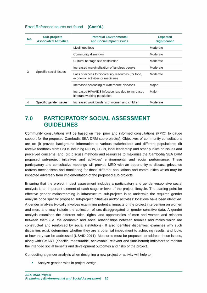
3 Specific social issues
Livelihood loss Moderate
Community disruption Moderate
Cultural heritage site destruction Moderate
Increased marginalization of landless people Moderate
Loss of access to biodiversity resources (for food,
economic activities or medicine)
Moderate
Increased spreading of waterborne diseases Major
Increased HIV/AIDS infection rate due to increased
itinerant working population
Major
4 Specific gender issues Increased work burdens of women and children Moderate
PARTICIPATORY SOCIAL ASSESSMENT 7.0GUIDELINES
Community consultations will be based on free, prior and informed consultations (FPIC) to gauge
support for the proposed Cambodia SEA DRM sub-project(s). Objectives of community consultations
are to: (i) provide background information to various stakeholders and different populations; (ii)
receive feedback from CSOs including NGOs, CBOs, local leadership and other publics on issues and
perceived concerns; and, (iii) discuss methods and resources to maximize the Cambodia SEA DRM
proposed sub-project initiatives and activities’ environmental and social performance. These
participatory and consultative meetings will provide MRD with an opportunity to discuss grievance
redress mechanisms and monitoring for those different populations and communities which may be
impacted adversely from implementation of the proposed sub-projects.
Ensuring that the project impact assessment includes a participatory and gender-responsive social
analysis is an important element of each stage or level of the project lifecycle. The starting point for
effective gender mainstreaming in infrastructure sub-projects is to undertake the required gender
analysis once specific proposed sub-project initiatives and/or activities’ locations have been identified.
A gender analysis typically involves examining potential impacts of the project intervention on women
and men, and may include the collection of sex‐disaggregated or gender‐sensitive data. A gender
analysis examines the different roles, rights, and opportunities of men and women and relations
between them (i.e. the economic and social relationships between females and males which are
constructed and reinforced by social institutions). It also identifies disparities, examines why such
disparities exist, determines whether they are a potential impediment to achieving results, and looks
at how they can be addressed (USAID 2011). Measures must be proposed to address these issues,
along with SMART (specific, measurable, achievable, relevant and time-bound) indicators to monitor
the intended social benefits and development outcomes and risks of the project.
Conducting a gender analysis when designing a new project or activity will help to:
Analyze gender roles in project design;

SEA DRM Project Preliminary Environmental and Social Assessment 21
Identify root causes of existing gender inequalities in that context so that they can be
addressed in the project design;
Identify different needs and priorities of men and women in both the near and long term;
Collect sex‐disaggregated baseline data;
Avoid perpetuating traditional power imbalances; and
Enhance the likelihood of strong and sustainable project results.
As indicated, MRD have proposed over seventy road sections for rehabilitation in six provinces. The
Consultant visited two provinces, including Tboung Khmum and Kratié between 13-17 June 2016.
One IP (i.e. Phnong ethnic group) village was identified in Kratié province and visited on 15th June
2016. In order to comply with the free, prior and informed consultation (FPIC) requirement and reduce
the influence of local authorities, the Consultant arranged to meet with the IP village shortly after
meeting with local authorities. The IP village is located in Koh Khnhaer Commune, Sambo District,
Kratié Province and is situated at the end of one of the proposed sub-project road lines. The
Kampong Phnong village chief accompanied the Consultant team but, was requested not to be
present during the interviews. The selection of households was made randomly and walk-in guided
interviews were conducted with respondents. The Consultant team split into two groups with the
female team leading interviews with female respondents and, the male team member interviewing
male respondents.
Results of the IP village consultation are covered more thoroughly in the IPPF document which is
appended to this ESMF. However, a few of the main findings are presented herewith to give the
reader more contextual understanding as to how a rehabilitated and improved rural access road could
affect different populations (i.e. ethnic minorities and vulnerable groups – women and female/male
youth and children, men, the elderly and disabled, etc.) both positively and negatively (adversely).
All of the female respondents welcomed any road and bridge construction initiative because it would
provide access to social infrastructure such as school, market and health facilities. Most of the female
respondents had heard of or, possibly, joined community planning meetings to discuss the commune
development plan, road construction and/or rehabilitation, health and sanitation awareness raising.
When asked about issues pertaining to voluntary land or asset contribution, the respondents indicated
that they had no reservation about contributing if the proposed road rehabilitation improved their
prospects, livelihoods and well-being. An elderly female respondent indicated that their traditional
culture supports cooperation and promotion of community well-being. The Consultant team noticed a
high rate of alcoholism in the IP village and one elderly female respondent suggested that an
improved road system enabled alcoholics access to commercial alcohol (i.e. higher volumes) as
opposed to consuming their traditional home-brewed alcohol. She indicated that alcohol poisoning
and deaths had increased in the community in recent years.
STAKEHOLDER CONSULTATIONS 8.0
IMPORTANCE OF STAKEHOLDER CONSULTATIONS 8.1
Public consultations occur at all stages of sub-project preparation and planning of feasibility studies
and detailed design. Public participation and consultations take place through individual, group or
community meetings. Additionally, different media may be used (e.g., public notice boards, official

SEA DRM Project Preliminary Environmental and Social Assessment 22
invitation letter, electronic communication including internet websites, email or cell phone) to
disseminate information. To ensure that World Bank consultation and disclosure policies are followed,
project affected people (PAP) and communities in the region of influence are engaged through free,
prior and informed consultation to gauge support for the proposed sub-project(s). In this manner,
stakeholders, various publics and different populations are consulted during several stages of sub-
project preparation, including:
Project Identification: preliminary consultations were conducted during sub-project
identification whereby national and local government authorities were consulted to ensure that
the Cambodia SEA DRM Project aligned with national policies and legal frameworks, sectoral
and local plans and strategies. Relevant stakeholders were consulted during development of
the ESMF. Documented records of engagement and consultations for Tboung Khmum and
Kratié provinces are located in Appendix A1 : Stakeholder Consultations;
Project Preparation: consultations will be conducted during preparation of the feasibility and
design studies to: (i) obtain detailed background information; (ii) conduct environmental and
social surveys; and, (iii) informing as well as collecting opinions of key stakeholders, various
publics and different populations on potential environmental and social impacts;
Project Implementation: for projects under World Bank Category “A” that might be nationally
controversial, a Communication Plan including a grievance redress mechanism will be
developed for the proposed sub-project(s) and implemented prior to implementation.
Participation of local leaders in disseminating information and resolving any disputes will be
important; and
Monitoring and Reporting: national and local level government, stakeholders, various
publics and different populations should participate throughout the proposed sub-project
development, implementation and operational period. Participation mechanisms should be
assessed during the feasibility and design phase.
SITE-SPECIFIC CONTEXTUAL GENDER INFORMATION 8.2
Field visits were conducted from 13-17 June 2016 to Tboung Khmum and Kratié provinces and
community consultations took place with a variety of local government and commune officials, civil
society and different populations (see Appendix 1 and Appendix 2 for list of stakeholders consulted
and stakeholder comments, respectively).
Depending on the location of the rural access road, people’s livelihood activities vary from farming
(i.e., rice cultivation, livestock rearing, seasonal mixed vegetative crops, and fishing) to non-farming
related activities such as market sellers, migrant workers (mostly on cassava farms, factories,
construction work). It is not surprising to find out that people living closer to district roads or markets
are better off than those communities at the end of the road line. In Tboung Khmum province, the
interviewed households living nearby the inspected road line (which is near the district area) own at
least one motorbike for each household compared to the IP villagers in Kratié who share their means
of transportation with relatives. The other interesting observation is the billeting arrangement for their
children’s education. One respondent in Tboung Khmum said he rented a room and bought a
motorbike for his child to study at the provincial school, while a respondent from the Kampong Phnouv
IP village could only afford to send their child to stay in pagoda (usually at a small cost or rent free)
and provide a bicycle to travel to school.

SEA DRM Project Preliminary Environmental and Social Assessment 23
The Cambodian Gender Strategic Plan-Neary Rattanak IV (2014-2018), a national strategic
document, informs the current decision-making process and notes challenges that women are facing.
The plan stated opportunities for women to participate in decision-making processes in sectors such
as economics, industry and energy; mines, urban management and transport. At sub-national level,
women face a number of challenges to participate effectively in public and political spheres, especially
workplace discrimination. Social perceptions of women as weak and less educated, general lack of
family support in carrying out political work, and low salaries, exacerbate discriminatory attitudes of
men towards women.
The public consultation meetings both at the national and community level were designed and
conducted by the Consultant with a strong focus on gender and women considerations. This is
reflected in the design of guided questionnaires, separate consultation meetings with gender working
group in the MRD, sub-national agencies such as the District Women and Children Committee
(DWCC) and Commune Women and Children Committee (CWCC), and separate female and male
focus group discussions, in depth interviews with female participants and female-headed households
by the Consultant’s female team member.
Gender mainstreaming and awareness is gaining ground and gender considerations are being
integrated into activities and plans ranging from national (Neary Rattanak IV to sector or ministerial
gender working group) to subnational planning level. For instance, in the annual commune investment
program, a gender section is included despite limitations on gender-disaggregated data related to
domestic and gender-based violence (GBV), human trafficking data, or road fatalities/accidents.
Gender mainstreaming activities from national to commune levels are likely to require awareness-
raising events and trainings. The commune investment plan reports on the number of women being
trained and the number of trainings organized. Besides gender awareness-raising, there is an
understanding that women need to attend meetings particularly commune planning meetings. This is
largely due to the requirement of commune and district planning guidelines from National Committee
for Sub-National Democratic Development (NCDD).
In the 14th June 2016 meeting with the Tboung Khmum Deputy District Governor and DWCC (i.e. the
committee assigned to work on maternal and child health, community pre-school, hygiene/sanitation,
gender equality and child protection), the Consultant team was informed that men and women are
segregated into two focus groups so they can discuss and voice their concerns and priorities separately
before they bring their development concerns from both parties to the main meeting. The current
commune planning practice does reflect the initial stage of ensuring gender equality and women
participation.
Nevertheless, it may be noted that women’s participation in meetings does not necessarily represent
an increase in women’s decision-making power. The DWCC member respondent mentioned her
participation in a dispute and settlement negotiation with a family potentially affected PAP by a road
construction project. The PAP wife agreed to voluntarily donate bamboo trees in front of her house for
the road rehabilitation project while her husband refused citing the economic value of the bamboo and
concern about the foregone earnings if they were donated voluntarily. The project team had to bypass
the area and consider an alternative design.
During the public and community consultations (13-17 June 2016), the Consultant held meetings with
CBOs and female community members. The key concerns voiced included issues related to: (i)
morbidity and mortality issues (i.e. maternal health and death); (ii) domestic and gender-based
SEA DRM Project Preliminary Environmental and Social Assessment 24
violence (GBV); (iii) sexual violence; (iv) temporary or seasonal migration (including rape cases on
girls when their mother was working away from home or early travel to school were mentioned); and
(v) and alcoholism. The concerns were brought mostly based on personal experience as a result of
their day to day experience, encounters during their work and occurrences in their community.
The abovementioned gender-related findings can be further interpreted and put into actionable
recommendations for the Cambodia SEA DRM Project, including:
Inclusion of gender considerations in early stages of the project is highly recommended. This
can be done by engaging gender expertise at project design and as an integral part of the
implementation team. The involvement with MRD’s Gender Working Group should be looked
at for both technical expertise and the possibility for building synergies across projects within
MRD. The link and information exchange between PDRD and gender focal points from both
national and subnational government entities and CBOs should be strengthened. Once
Cambodia SEA DRM proposed sub-project locations have been identified then, sufficient time
and budget should be set aside to conduct a thorough gender-related analysis;
Regarding the criteria of selection for road lines, in addition to the five criteria proposed by the
World Bank, the analysis should consider ethno- and socio-cultural, demographic and socio-
economic information pertaining to livelihoods and gender considerations to inform the roadworks
section or package selection criteria. Representatives from the District Council and DWCC
brought gender issues to light in proposed road lines. One of out 11 proposed road lines is
believed to be beneficial to women and vulnerable groups in terms of enabling them to access
social infrastructure (such as health center and schools), which currently get cut off by bad road
conditions;
Ensuring equal participation amongst men and women in the planning process remains the key
to informed sub-project development. The current participation mechanism guarantees
women’s involvement and this practice should be sustained. It should be noted that many
consulted household members (mostly female respondents) complained about the lengthy
process or gap between prior consultation and the actual implementation of the project. One
villager said she was asked to join many meetings but the road construction has not been
started. Therefore, any consultation with communities should be handled properly to avoid
raising expectation. The community should be well informed about how the project will be
implemented, what the outputs will be and what the expected benefits are (i.e. the reason for
doing the project);
The shift in decision making and balance of power between men and women is a gradual
process which demands effort to be invested in further capacity building, knowledge and
awareness-raising amongst women and, which should done by involving men so as to gain their
support for more inclusive decision-making. The Cambodia SEA DRM Project could contribute
to this gender mainstreaming process and women’s empowerment in an incremental manner;
and
During consultation meetings, ideas and best practices from other projects involving and
empowering women were explored. For instance, the practice of assigning a quota of female
laborers during construction is very much agreed upon. In one of the Commune Council
meetings, a Council Representative recognized the role of community involvement and,
particularly, women’s role in monitoring the quality of work by the road construction company.
Therefore, it is suggested the role of community monitoring and reporting (particularly,

SEA DRM Project Preliminary Environmental and Social Assessment 25
women’s potential involvement) should be well reflected in the construction contractor(s)
terms of reference and tender documents.
Some best practices were identified during the public and community consultations and should be
considered and/or written into subsequent sub-project roadworks rehabilitation contracts. These
include:
Contractors will not employ child labor on civil works contracts;
Road shoulders will be sealed surface enabling carts with wheels;
Capacity building of local contractors on gender and labor-based appropriate technology;
Sex disaggregated database to track the use of local labor;
Community contracts to women for sustainable road maintenance works;
At least 50% women road side maintenance workers;
All project roads with speed bumps in villages and road safety signage;
A community-based road safety campaign with 50% women facilitators;
Inclusion of HIV/AIDS and human trafficking prevention programs during and after construction;
and
Climate change adaptation will include community-based work programs involving women in
planting and caring for road-side trees and other plants.

APPENDICES

Appendix A1
List of Consulted Stakeholders

SEA DRM Project Preliminary Environmental and Social Assessment A1-1
Table A1.1 List of consulted stakeholders.
Date Stakeholders Methodology Location
13 June 2016 MRD Provincial Department
officers, Commune
Councils, clerk, village chief
Arranged meeting with Q and A. Mean Commune,
Tbuong Khmum
Province
People living along the
proposed road line
Random household interviews;
selection based on the location of
households: the beginning, the
middle, and the end of road line; 5
households were interviewed,
comprising of a small business
owner couple, an elderly housewife,
a cake seller, a pregnant woman, a
young farmer and fisherman, and a
middle-aged farmer.
Handicap International
Supported Local Health
Clinic
Walk in meeting (non-arranged
meeting).
Commune councils, clerk,
village chief
Arranged meeting with Q and A. Roka Por Pram
Commune, Tbuong
Khmum Province
14 June 2016 Deputy district governor
District Women and Children
Committee
Arranged meeting with Q and A. District governor
office, Tbuong Khmum
Province
15 June 2016 MRD Provincial Department
and commune
representatives
Arranged meeting with Q and A. Kratié Provincial
Department of MRD
Commune councils, clerk,
village chiefs, Commune
Women and Children
Committee, Representative
from Agriculture Community,
communities members from
Sambo Commune and Koh
Khnhaer Commune
Gender segregated focus group
meeting: the men group led by
PDRD official and Dr. Dok Doma
and the women group coordinated
by Ms. Seng Bopha.
Resource mapping and focus group
discussion.
Indigenous communities at
Kampong Phnouv Village
Random household interviews,
comprising of one woman-headed
household, a housewife and
seasonal migrant worker, an elderly
housewife, a female farmer, a school
teacher.
Kampong Phnouv
Village, Koh Khnhaer
Commune, Sambo
district, Kratié
Province

SEA DRM Project Preliminary Environmental and Social Assessment A1-2
Table A1.1 (Cont’d.)
Date Stakeholders Methodology Location
16 June 2016 CBO representatives from
Chada (funded by Plan
International), Flo working
on IPs, Childfund, Samarita,
and WWF
Arranged meeting with Q and A (the
meeting was organized by the
PDRD; however, the representatives
from the department were not
involved in the discussion to ensure
lesser degree of influence and bias).
Kratié Provincial
Department of MRD
District governor
District Women and Children
Committee
Arranged meeting with Q and A
17 June 2016 CBO representatives from
Clean Water 1001
(Technical support from a
French organization) and
Khemara
Arranged meeting with Q and A (the
meeting was organized by commune
councils; however, the
representatives from the councils
were not involved in the discussion
to ensure lesser degree of influence
and bias).
Roka Por Pram
Commune, Tbuong
Khmum Province

Appendix A2
Stakeholder Consultations

SEA DRM Project Preliminary Environmental and Social Assessment A2-1
Provincial Public Consultation in Kratié Province
Kratié Province 75 participants from different groups participated in the public consultation meeting in three different places (15 PDRD, 40 Sambo and Koh Knher Commune, and Kampong Pnov 20 Village of Indigenous People)
At provincial level, the meeting was attended by director of PDRD and other 9 staffs. In separate place, the meeting was attended by 5 NGOs/CBOs representatives.
At community, the meeting was attended by 30 head and ordinary villagers, including all commune councils and head of commune.
At indigenous people village, household interview was randomly conducted with about 20 families where the location of their houses located in different places.
Both consultation meeting and household interview were interactive with precise questions and issues raised as below. The interview took about 4 hours across the whole village of indigenous people (IP).
There were several issues raised during each consultation, the below are only key issues that described in relation to environmental and social, as well as safeguards protection.
Sambo and Koh
Knher Commune,
PDRD Office.
Rising Issues/Questions Responses
What is the geographical condition of the Kratié Province?
Head of PDRD: The province is large territory and has a boundary with various environmental protected areas, which fell inside and vicinity of the province center. With quite high population growth and with the growth of IP the province has challenged with environmental and social protection and made the balance of development and conservation level.
Head of rural development planning office: the province exposes to floods and droughts yearly, particularly this year the droughts has damaged farming system seriously. Remote areas are so poor who fell below poverty rate, which requires infrastructure development interventions from various corners of agencies.
Flora Organization: Because of the province attached with various natural resources, human and climate change have damaged them drastically, and need to have real intervention to project environment of the province.
How the road networks proposed for this project were selected
Head of PDRD and key staff: We have proposed various road networks in the remote area to the ministry of rural development. Of cause, this proposal does not select by random method, but we selected in according to the following adverse factors:
o The level of poverty is high in comparison to various areas in the province.
o Farm lands are productive, but those locations are facing more dry and inundation than the others which damage their agricultural farm.
o The road networks are importantly to connect suppliers and demands at the regional markets.
o Conditions of the roads are already existed strong base, but they need to strengthen surface covers.
WWF: we do not know where the proposed roads are, but we would recommend that if the roads are inside or adjacent to the protected areas, the government should pay attentions to environmental wildlife animal, fauna and flora safeguards protection during either project implementation and after post-project.
Flora Organization: selected road for construction must be in the priority of low income areas, real insufficient of rural infrastructure in the communes, provide agricultural value chain to increase local livelihoods, but must be not to hurt poor people, environment, or IP.
How the rural road construction affected to rural society?
SOCIAL:
Child Fund: Road construction provides more positive than negative

SEA DRM Project Preliminary Environmental and Social Assessment A2-2
Rising Issues/Questions Responses
because rural children easily attend school and health care center, but the must indicate during road construction that dust and noise must be control to avoid any impacts on children either during their travelling or during their learning at school. Much accidence has been happening during the road construction because they have not made the children path safety going and returning from school. School traffic road safety education must be integrated into their program either officially or unofficially. Subjects related to roads impacts such as road safety, road asset (sign board, and line making, or others) must be disseminated to beneficiary’s households which include women and children as well.
Deputy director of PDRD:
Commune councils of Sambo: Although people need rural road construction in their villages, but it is experienced that during the road construction there are a lot of problems happed such as land and tree affected, therefore, it is needed to clearly conduct short time assessment to ask people if they have willingness to contribute land either voluntary contribution or they need affected land acquisition.
Villager of Knhe Commune: They need to have Disclosure meeting on the rights of land users, land owners.
Added by Chief of Knher Commune: We need land survey to identify the affected land, fence, and tree of the villagers.
Chada Organization: they need to prepare survey map and schedule of land acquisition prior to decide road construction.
Most of people at commune public consultation: Agreed that the authorities must conduct a meeting with villagers for discussion and agreement prior to make decision.
Chief of PDRD and all staffs: Detail of land loss are very important before conducting a meeting with villagers and communities and ask them whether they agree for land contribution or not.
All NGOs and CBOs: agreed that approval on land study report is very important that government should have explicit mechanism to judge whether land study is right or wrong.
90% of participants at commune public consultation: Urged that to avoid women migration and children’s class drops, job opportunities either during road construction or after road construction must be created, during road construction should be involved a significant number of women working as a labors and should educate children over road safety and road assets management.
Both PDRD and all NGOs: Raised that the procedure of land studies, checking, verifying, and approval must be clear and involve local people to participate in the process.
Any issue on environmental impacts is emerged due to road construction?
ENVIRONMENT:
Chief of communes, chief of villagers confirmed minor environmental impacts such as dust, noise, more people encroachment after road construction, and soil excavation (borrow pits) can be a risk for animals and human if their place is depth and no fence surrounding.
All agreed, that the borrow pits must be converted into adequate water retention ponds used for human and animal in dry season.
NGOs and CBOs: Raised their concerns over the degradation of natural resources in the protected places due to people encroachment after the road construction. They have experiences over the land encroachment, constructing houses close to protected areas or along the roads, cutting trees and transport through constructed roads, and
Sambo District Governor: Check list of environmental impacts must be done although minor impacts. The environmental impacts analysis list is to confirm how the impacts look like, such as a long term
SEA DRM Project Preliminary Environmental and Social Assessment A2-3
Rising Issues/Questions Responses
environmental impacts and short term environmental impacts. It must be distinguished clearly.
Any people should join with environmental protection for road construction?
PDRD and CBOs: The Environmental Analysis should be carried out by a provincial official who should be trained to do this work and with the participation of the people (villagers and councils) who can be affected by the project. Ordinary people should be encouraged to take part, not just the C/S chief or other people who are involved in promoting the project. It is best if many different types of people participate – young people and old people, women and men, farmers, monks, etc.
District Official: The Environmental Analysis (EA) must be done although this is minor impacts to the rural people. It should be done near the project site, at a public location where it is convenient for people to participate. For some projects it will be necessary for the official responsible for the analysis to walk over the project site together with local people.
Who should participate and know about the project for environmental protection?
Chief of commune, Sambo and one of Commune councils: The PDRD technical engineer should begin by making sure that the people, commune level, who participate in the analysis, know about the project. Rural people should know clearly how the project will be implemented, what the outputs will be and what the expected benefits, (the reason for doing the project), are.
Commune of Knhel: Then the engineer should explain the reason why it is necessary to carry out an environmental analysis for this project. The official should make sure that the people understand that the result of the analysis will be recommendations only – sometimes it may happen that recommendations are made during the analysis, but it is not possible to follow the recommendations fully.
How will the long term impacts be done? Provide more examples please?
WWF, Flora suggest that: the below impacts must be identified during project screening:
o Increased threats to endangered wild animals known to live in the area.
o Damage to the forests (especially in bio-diversity area)
o Impact on sustainability of wetlands or water sources (especially in protected or bio-diversity areas)
o Long term damage to agricultural land
o Erosion caused by changes to alignment or size of streams
o Erosion caused by removing vegetation
o Flooding
o Damage to water quality due to chemical pollution
o Long term impact causing by dust, noise and safety problems
IP of Knouv suggested that:
o Damage to the livelihood, living environment or customs of indigenous people
Community suggested that:
o Damage to the fisheries resources and fisheries stocks

SEA DRM Project Preliminary Environmental and Social Assessment A2-4
Rising Issues/Questions Responses
Any other impacts during road construction?
Most of public consultation participants confirmed that:
o Short-term environmental impacts mostly occur during the project implementation. Short-term environmental impacts can be ameliorated by implementing the environmental management activities described in contractor’s or service provider's work plan and environment management plan.
Save the Children: short term consists of contamination of water resources during construction, damage to home gardens and fruit trees, Damage to domestic water supplies, noise and dust problem during construction, and Damage will be caused by vehicles transporting materials to the site.
What should we do to address longer term and short term impacts?
On EMP and Monitoring Plan
All at provincial and community meeting, but not household level, confirmed that project must have environmental management plan.
WWF and Save the Children:
o The environmental management plan must show what changes to the project are recommended to reduce the bad impacts on the environment.
Commune councils claimed to have monitoring plan. Environmental monitoring plan must indicate what the impacts are, where the impact is may occur, when it is actually happened, how to challenge it, who supposed to have privilege to do this.
Commune chief of Khnel said: It must have mitigation measures clearly and participated by local community.
Suggestion from All Cost of damage of environment must be set or calculated to make sure that project should provide compensation if the event that there is a serious environmental impact or short term impacts.
Provincial Public Consultation in Tboung Khmum Province
Tboung Khmum Province
37 participants from different groups participated in the public consultation meeting in three different places (3 PDRD, 20 Mean and Roka Por Pram Commune, 3 from District Governor and District Women and Children Committee [DWCC] and 8 community members from proposed road line and 3 representatives CBOs.)
At provincial level, deputy director of PDRD and 3 staff members attended the meeting from Deputy District Governor and District Women and Children Committee.
At commune level, 20 representatives including all commune councils, clerk, and village chiefs from both Mean and Roka Por Pram Commune attended 2 separated meetings.
At community level, random household interviews were conducted with 8 families. The selection was based on the location of households from the beginning, middle and end of the proposed road line. The household interviews were guided by a set questionnaire. The interviews took about 3 hours in total.
Two separate meetings were conducted with CBOs with 3 representatives from Handicap International, Safe Water 1001, and Khmera.
Mean and Roka Por Pram Commune, PDRD Office,
Rising Issues/Questions Responses
What is the geographical condition of the Tboung Khmum Province?
The proposed road line connects three communes namely Mean, Apel Tapork, and Mohaleap. Some section of the road affected by flood yearly, while drought happened almost year. Maximum flood is 1.2 m occurred at the end of road.
There are local brick factories operating around the road line. Heavy truck carrying brick and factory materials such as laterites and gravels are believed to be the main cause in deteriorating the condition of the road.

SEA DRM Project Preliminary Environmental and Social Assessment A2-5
Rising Issues/Questions Responses
How the road networks proposed for this project were selected
There was a discussion on criteria in selecting road lines with PDRD during a meeting among the Deputy District Governor and District Women and Children Committee, and PDRD representatives. The mission team randomly picked one among 11 proposed roads from PDRD.
The selected and inspected road is Charn Nimith-Prapath road line with 7.5 km length and 5 m width.
This road network is claimed to be of great significance in term of market, school, and health center access.
Conditions of the roads are already existed strong base; however, due to the heavy loads of transportation, some areas of the road line got damaged, particularly at the end of the road line.
There was also discussion on other proposed lines raised by a representative from DWCC in term of access for rural women to health center. Due to the condition of the road and time constraint, the mission team was unable to inspect the whole road line.
The mission team also inspected one of the top ranked road lines. Nevertheless, the road does not reflect well on the five main criteria proposed by the World Bank for road selections.
How the rural road construction affected rural society?
Community response: from all the household interviews, there is no one who disputes the benefits of having better road access. All of the participants are willing to contribute their tree, fence, or temporary shop house of their own volition (i.e. land donation) if their properties encroach on the road line while being rehabilitated. One of the consulted correspondents said that he has no hesitation to donate his properties if there is a requirement by the authority and if his neighbors were required to do so also. This reflects the importance of peer influence in the community.
When asked to identify any adverse social impacts resulting from the proposed road construction or improvement, most of the respondents could not provide any answer. They mostly agreed to the noise and dust during the construction; nevertheless, the villagers already complained about the heavy dust during the dry season and mud during raining season with the current road condition. One villager said that she is always having a dust bath every day. One villager said he rented a place for his daughter to stay closer to school to avoid bad traffic.
When being asked if improved road condition can result in higher migration rate, many villagers said that that is a normal migration practice for farmers who use dry season to seek job opportunities outside their villages. A young seasonal migrant labor said most of his peer group are working in garment factories, construction sites, and farms in other communes and provinces.
Khemara: No one denies the great importance of access to roads in development and improved livelihood. Khemara representative said that it is safer for children to travel to school if there is better road. If the condition of the road is bad, the children need to commute at dawn time to make it to early class, which can result in violence or rape. Access to rural communities through better road condition is undeniably beneficial to their awareness raising and training work, particularly when all the trainings and workshops are done in direct face-to-face meetings.
Safe Water 1001: This local organization representative welcomed the idea of improved road condition, which can facilitate their water supply to remote communities.
Deputy director of PDRD: Ensure gender equity and balance in participation: there is gender consideration in community participation in term of ensuring the participation among men and women. In one commune case, there is 60% of women (20% of which is youth below 35 years old) participated in the commune planning meeting.

SEA DRM Project Preliminary Environmental and Social Assessment A2-6
Rising Issues/Questions Responses
The current practice during commune planning, men and women are segregated into two focus groups so they can discuss and voice their concerns and priorities separately before they bring the development concerns from both parties for the main meeting. This is where the power struggle comes in to play.
When it comes to decision-making power, it is interesting to note that women still need to listen to their husbands for final decision. A real-life case from DWCC member who participated in dispute and settlement negotiation with a family affected by a road construction project. The wife agreed to donate bamboo trees in front of her house for the road rehabilitation project while her husband refused. The project team had to bypass the area and found other alternatives.
For women headed household, women are occupied with earning income so the participation is lacking. She will rely on getting information from village chief and her neighbor.
From DWCC, women played strong role in dissemination of information.
Any issue on environmental impacts is emerged due to road construction?
Consulted people living by the road line strongly recognize the disruption during construction phase; however, the current dusty and fragmented road condition they are facing is more unbearable and disturbing than the short-term construction phase.
Commune council members recognized environmental impacts such as dust, noise, and people encroachment after road construction, and soil excavation (borrow pits) can be a risk for animals and human if there is place is depth and no fence surrounding.
Any people should join with environmental protection for road construction?
In one of the Commune Council meeting, a Council representative recognized the role of community particularly women in monitoring quality of work of construction company. Therefore, it is suggested the role of community monitoring and reporting should be well reflected in contractual arrangement with construction firm(s).
Who should participate and know about the project for environmental protection?
Public and community participation is strongly reflected in many commune development-planning guidelines by NCDD. The Deputy District Governor mentioned the current dissemination mechanism is believed to be successful. There are three dissemination meetings conducted prior the road construction begins. The first meeting is the introduction about the objectives and importance of the projects to the community. For the second meeting, the affected households are informed if there is any loss of properties happening during road construction. Two weeks prior notice is given to all affected families for decision making within their family if they agree to contribute land voluntarily.
How is about the long term impact should be done? Provide more examples please?
Possible illegal logging transportation, mentioned one of consulted community members during nighttime.
Possible damage if there is no maintenance and control plan on heavy loaded transportation.
Long term damage to agricultural land.
Erosion caused by changes to alignment or size of streams.
Erosion caused by removing vegetation.
Climate change-extreme weather of longer drought and flood.
Any other impacts during road construction?
Discussion on road safety particularly around school areas was made. A great emphasis on safety for children should be included. Khemera representative said that there is an initiative to teach pre-school children with visual aids on road safety in their community kindergarten project.
Through various commune meetings and village chief’s door-to door announcement, almost all interviewed villagers were informed about possible loss of home gardens, trees, fences and shop houses.
What should we do to address longer term and
Safety guidance for travelers specifically school children should be
included and implemented.

SEA DRM Project Preliminary Environmental and Social Assessment A2-7
Rising Issues/Questions Responses
short term impacts?
On EMP and Monitoring Plan
Monitoring plan during construction and maintaining plan after the construction should involve more community. Awareness on road as common and public goods should be encouraged. Throughout the consultation process, no one disputes the importance of road as his/her access to better livelihood. Everyone wants good quality roads, yet there is no strong mechanism for maintaining the road quality. Some of the road lines have been repaired many times.
Suggestion from All While the dissemination process of understanding and accepting the environmental and social protection from developing road construction were normally conducted by DWCC and CWCC, there is a need for continued strengthening of capacities at local and provincial, district commune and populace levels on specific social and environmental impacts and measures. This should be complemented by strengthening awareness and understanding within the MRD that is responsible for road safeguard implementation. Key capacity issues are: Natural Resources Protection, People Rights of land Possession, long and short term impacts during project and post project construction.
It is reported that awareness of environmental impacts is mostly confined to impacts upon forest and wetland areas along project sides with little consideration of the broader environmental impacts there may be. For example, the implications that construction of a road that increases access to a forested area may have for forest clearance or tree collection is not generally considered widely among the stakeholders such as local people, authority, CBOs, and even local public servants.
It should be noted that many consulted household members complained about the lengthy process or gap between prior consultation and the actual implementation of the project. One villager said she was asked to join many meetings but the road construction has not been started so far. Therefore, any consultation with communities should be handled properly to avoid raising expectation. The community should be well informed how the project will be implemented, what the outputs will be and what the expected benefits, (the reason for doing the project), are.
Involving women and elderly in the process of monitoring and road construction with contracted firm can generate more incomes.

Appendix A3
1st
Public Consultation Meeting Sign Up Sheets

SEA DRM Project Preliminary Environmental and Social Assessment A3-1
Figure A3.1 Sambo Commune sign up sheet.
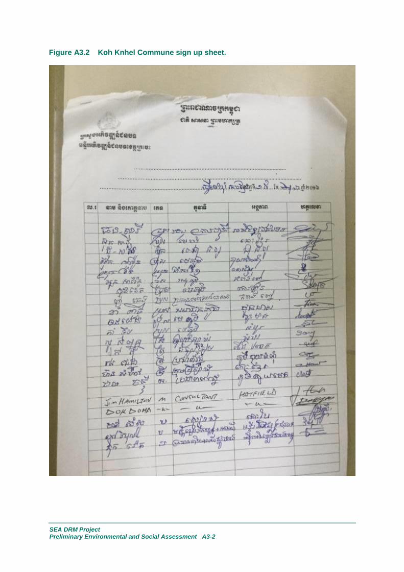
SEA DRM Project Preliminary Environmental and Social Assessment A3-2
Figure A3.2 Koh Knhel Commune sign up sheet.

SEA DRM Project Preliminary Environmental and Social Assessment A3-3
Figure A3.3 Tboung Khmum District sign up sheet.
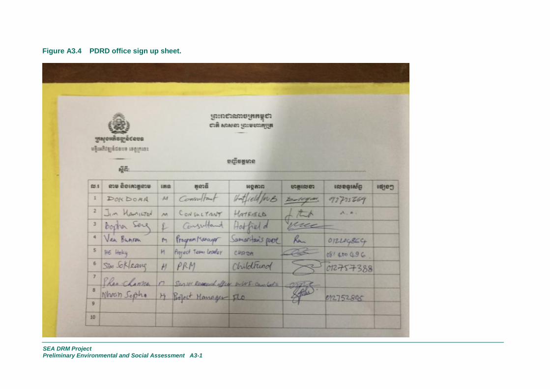
SEA DRM Project Preliminary Environmental and Social Assessment A3-1
Figure A3.4 PDRD office sign up sheet.

SEA DRM Project Preliminary Environmental and Social Assessment A3-2
Figure A3.5 NGOs consultation sign up sheet.

Appendix A4
2nd
Public Consultation Meeting Sign Up Sheets

Placeholder page - sheets to be provided following the 2nd
public consultation meeting.