World Bank Documentdocuments.worldbank.org/curated/en/... · Brazil is the world's largest exporter...
65
Documentof The World Bank FOR OFFICIAL USE ONLY Report No. 3845a-BR STAFF APPRAISAL REPORT NORTHEAST BRAZIL MARANHAO RURAL DEVELOPMENT PROJECT May 21, 1982 Projects Department Latin America and the Caribbean Region Office This document has a restricted distribution and may be used by recipients only in the performance of | their official duties. Its contents may not otherwise be disclosed without World Bank authorization. | Public Disclosure Authorized Public Disclosure Authorized Public Disclosure Authorized Public Disclosure Authorized Public Disclosure Authorized Public Disclosure Authorized Public Disclosure Authorized Public Disclosure Authorized
Transcript of World Bank Documentdocuments.worldbank.org/curated/en/... · Brazil is the world's largest exporter...

Document of
The World Bank
FOR OFFICIAL USE ONLY
Report No. 3845a-BR
STAFF APPRAISAL REPORT
NORTHEAST BRAZIL
MARANHAO RURAL DEVELOPMENT PROJECT
May 21, 1982
Projects DepartmentLatin America and the Caribbean Region Office
This document has a restricted distribution and may be used by recipients only in the performance of |their official duties. Its contents may not otherwise be disclosed without World Bank authorization. |
Pub
lic D
iscl
osur
e A
utho
rized
Pub
lic D
iscl
osur
e A
utho
rized
Pub
lic D
iscl
osur
e A
utho
rized
Pub
lic D
iscl
osur
e A
utho
rized
Pub
lic D
iscl
osur
e A
utho
rized
Pub
lic D
iscl
osur
e A
utho
rized
Pub
lic D
iscl
osur
e A
utho
rized
Pub
lic D
iscl
osur
e A
utho
rized

CURRENCY EQUIVALENTS
Currency Unit = Brazilian Cruzeiro (Cr$)US$1.00 = Cr$100.68 1/
Cr$1.00 = US$0.009932Cr$1 million = US$9,932.46
WEIGHTS AND MEASURES
The metric system is used throughout the report.
FISCAL YEARS
Government of Brazil = January 1 to December 31
POLONORDESTE Program = April 1 to March 31
Project Year = April 1 to March 31
1/ Exchange rate at time of appraisal (August 1981). The exchange rate onApril 30, 1982 was US$1 = Cr$154.8.

FOR OFFICIAL USE ONLY
GLOSSARY OF ACRONYMS
BB Banco do Brasil(Bank of Brazil)
BNB Banco do Nordeste do Brasil(Bank of Northeast Brazil)
BNCC Banco Nacional de Credito as Cooperativas(National Bank for Credit to Cooperatives)
COTERMA Companhia de Coloniza,ao e Terras do Maranhao(State Land and Colonization Company)
CEASA-MA Centrais de Abastecimento do Maranhao(State Food Supply Centers)
COMABA Companhia Maranhense de Abastecimento(State Input Supply Company)
COPENAT Companhia de Pesquisa e Aproveitamento deRecursos Naturais
(State Company for Research and Use of Natural Resources)
CODERMA Companhia de Desenvolvimento Rodoviario do Maranhao(State Company for Road Development)
COLONE Companhia de Coloniza,ao do Nordeste(Colonization Company of the Northeast)
CEAG-MA Centro de Apoio a Pequena e Media Empresa do Maranhao(State Center of Support for Small and Medium Enterprises)
DERMA Departamento de Estradas e Rodagem do Maranhao(Road Construction and Maintenance Agency of Maranhao)
EMATER-MA Empresa de Assistencia Tecnica e Extensao Rural-MA(Technical Assistance and Rural Extension Agency-MA)
EMAPA Empresa Maranhense de Pesquisa Agropecuaria(State Agricultural Research Company)
EMBRAPA Empresa Brasileira de Pesquisa Agropecuaria(Brazilian Agricultural Research Agency)
FCAP Faculdade de Ciencias Agrarias do Para(Agricultural Faculty - Para University)
FSESP Fundacao Servico Especial de Saude Publica(Foundation for Special Public Health Services)
This document has a restricted distribution and may be used by recipients only in the performanceof their official duties. Its contents may not otherwise be disclosed without World Bank authorization.

FUNAI Fundac,ao Nacional do Indio(National Indian Foundation)
ICM Imposto sobre Circula,ao de Mercadorias(Tax on product circulation)
ITERMA Instituto da Terra do Maranhao(State Land Institute)
INCRA Instituto Nacional de Colonizagao e Reforma Agraria(National Institute of Colonization and Agrarian Reform)
IBDF Instituto Brasileiro de Desenvolvimento Florestal(Brazilian Forestry Development Institute)
POLONORDESTE Programa de Desenvolvimento de Areas Integradas doNordeste
(Development Program for Integrated Areas in theNortheast)
REPEMIR Reflorestamento em Pequenos e Medias Imoveis Rurais(Reforestation Program for Small and Medium Farms)
SUDENE Superintendencia do Desenvolvimento do Nordeste(Northeast Economic Development Superintendency)
SIMA Servigo de Informacao de Mercado Agricola(Agricultural Marketing Information Service)
SUCAM Superintendencia de Campanhas Medicinais(Superintendency of Public Health Campaigns)
SERNAT Secretaria de Recursos Naturais do Maranhao(State Secretariat for Natural Resources)
SE Secretaria de Educa,ao(State Secretariat for Education)
SES Secretaria de Saude(State Secretariat for Health)

NORTHEAST BRAZIL
MARANHAO RURAL DEVELOPMENT PROJECT
STAFF APPRAISAL REPORT
Table of Contents
Page No.
I. THE AGRICULTURAL SECTOR ................................ 1
Agriculture in the Economy ............................. 1Rural Development in Northeast Brazil .... .............. 1Bank Involvement in the Agricultural Sector .... ........ 2
II. THE STATE OF MARANHAO AND THE PROJECT AREA .... ......... 3
A. The State .......................................... 3
Location and Natural Features .............. 3Social and Economic Conditions .............. 3Agricultural Production and Land Tenure ......... 4Rural Development ............................... 5
B. The Project Area ...... ...................... 5Location and General Features ................. .. 5Socioeconomic Conditions .... ................... 6Land Distribution and Settlement ................ 6Agricultural Production ......................... 7
Production Support Services ..................... 8Social Services ..... ...................... 8Physical Infrastructure .... .................. 8
III. THE PROJECT ............................................ 9
A. Origin ....... ......................................* 9
B. Objectives and Strategy ..... ....................... 10C. Brief Description ..... ............................. 12D. Detailed Features ...... ............................ 13
Land Regularization and Redistribution Activities 13Land Use Capability and Planning Studies ........ 16Agricultural Research and Seed Production ....... 17Rural Extension ................................. 18Marketing, Input Supply and Cooperatives ........ 20
This report is based on the findings of an appraisal mission in August/September 1981 composed of G. Hayes, A. Hartmann, L. Coirolo, D. Dowsett,S. Kowalski (Bank) and E. Andrade, D. Braga, J. Landers, D. Larson, T.Ramos-Saco, J. Strasma and F. Yepes (Consultants).

Table of Contents (Continued)
Page No.
Inland Fisheries ................................ 21
Forestry Development ............................ 22
Small Scale Enterprises ......................... 22Rural Transport ................................. 23
Education and Vocational Training .... ........... 25Health and Water Supply ......................... 26
Project Administration .......................... 27
E. Complementary Activities ........................... 27Credit .......................................... 27Amerindian Protection ........................... 28Agricultural Development in Mearim-Pindare ...... 28
IV. PROJECT COSTS AND FINANCING ............................ 29
Project Costs .......................................... 29Financing .............................................. 31Procurement ............................................ 32
Disbursements .......................................... 32
V. PROJECT IMPLEMENTATION ................................. 33
Organization and Management ............................ 33Planning and Operating Procedures ...................... 35
Accounts and Auditing .................................. 37Monitoring and Reporting ............................... 37
Evaluation ............................................. 38
VI. PRODUCTION, DEMAND, MARKETS AND PRICES ................. 38
Agricultural Development Strategy ...................... 38Production ............................................. 39
Demand, Markets and Prices ............................ 40
VII. FINANCIAL ANALYSIS ..................................... 41
Illustrative Farm Models ............................... 41Farm Producer Income ................................... 42Small Scale Enterprises ............................... 42Fiscal Impact .......................................... 42
VIII. ECONOMIC BENEFITS AND JUSTIFICATION .................... 43
Economic Rate of Return ................................ 43Employment ............................................. 45Environmental Impact ................................... 45Impact on Women ........................................ 45Project Risks .......................................... 46
IX. SUMMARY OF AGREEMENTS REACHED AND RECOMMENDATION ........ 47
APPENDIX. List of Documents Available in Project File.. 51

Table of Contents (Continued)
MAPS
1. Project Area and Rainfall (No. 16151)2. Population Density and Project Works (No. 16152)3. Agricultural Aptitude and Rainfall (No. 16153)
VOLUME II - TECHNICAL ANNEXES AND CHARTS*
ANNEXES
1. Land Regularization and Redistribution2. Agricultural Development3. Farm Models and Project Outputs4. Estimated Schedule of Bank Disbursements5. Institutional Responsibilities6. Key Indicators for Monitoring and Evaluation7. Supporting Tables and Charts
* Available upon request

NORTHEAST BRAZIL
Maranhao Rural Development Project
Staff Appraisal Report
I. THE AGRICULTURAL SECTOR
Agriculture in the Economy
1.01 Though its relative importance in the Brazilian economy hasgradually declined, agriculture remains an important sector, employing 36%of Brazil's labor force, contributing over 10% of the total GDP, and abouthalf of total export earnings. Some 36% of Brazil's 1980 population of 119million now live in rural areas, compared to 39% in 1970. The averageannual agricultural growth rate in the decade to 1980 was just over 5%.Brazil is the world's largest exporter of coffee and orange juice, thelargest producer of sugar cane, and the third largest producer ofsoybeans. Other major agricultural exports include meat and fish products,cotton, peanuts, cocoa, castor oil, and sisal. In most years Brazil isself-sufficient in basic food production, except for wheat. Bad crop yearsresult in periodic imports of basic food crops such as maize, rice andbeans. Natural rubber is also imported. Most of the productivity gains,expanded production areas, and increased market integration experienced inthe recent past have occurred in the south and center-west of the country,while the north and northeast have largely continued to use traditionalagricultural practices with rudimentary technology. Constraints onincreased agricultural production, particularly in the less developedNortheast, are discussed below (paras 1.03-1.04).
1.02 Agricultural development has been assigned a high priority inBrazil's 1980-1985 development plan. It is given a key role in theGovernment's efforts to reduce inflation, through expanded food production,and, to improve balance-of-payments, through increased production of exportcrops and energy substitutes. To help achieve these objectives, theGovernment has continued its support for special regional programs, despitehigh inflation and public sector deficits which have caused restraint inpublic expenditure elsewhere. The Government is also trying to reduce itsuse of the very high agricultural credit subsidies, an instrument usedextensively in the past decade; however, the subsidy on regular ruralcredit remains high.
Rural Development in the Northeast
1.03 The nine states of Northeast Brazil have a population of about 35million (1980), of whom about half are rural. The region's totalpopulation increased at a net rate of about 2.2% per year between 1970 and1980, although the rural population growth was slower. Much of the regionhas a semi-arid climate with serious periodic droughts, and there areextensive areas of poor soils. Nonetheless, the Northeast is a significantagricultural region, with about 30% of Brazil's harvested area and 45% of
- 2 -
its agricultural workforce, which produce a major share of the nationalproduction of cocoa, cotton, beans, rice and sugar.
1.04 Although some crops such as sugarcane are grown predominantly onlarge farms, basic food crops are produced mainly by small farmers,employing rudimentary technology and obtaining low yields. Development ofthe agriculture of small farmers has been hampered by: limited access toimproved seeds and other inputs, to rural extension services, and toworking capital and investment credit; market isolation and weak linkageswithin the regional economy; and, in some areas, by a relativelyunfavorable physical environment. Insecurity of land tenure and lack ofaccess to land have compounded these difficulties and, in many areas,constitute the basic constraint to increased production and productivity ofsmall farmers.l/
1.05 Various Government programs have been directed at speedingeconomic development in the Northeast. The Government operates a specialagency, the Northeast Economic Development Superintendency (SUDENE), and aspecial development bank for the Northeast, Bank of Northeast Brazil(BNB). Substantial fiscal and monetary incentives have been made availableover the past two decades for both industry and agriculture. Programs togenerate jobs in the industrial sector have not, however, kept pace withthe population movement to the cities and to the more industrializedCenter-South and Center-West of Brazil. Prior to the mid-1970's,Government programs directed to the rural population of the Northeastconcentrated on public works, with substantial efforts in drought-proneareas to develop dams and ponds. Subsequently, efforts were initiated tostrengthen the institutions offering the support services required todevelop more productive farming systems. Such efforts include thePOLONORDESTE program (which the Bank has helped finance), Sertanejo, andirrigation programs. POLONORDESTE, the most ambitious of these efforts, isa wide-ranging program aimed at raising living standards through a seriesof area-based integrated development projects where a comprehensive rangeof measures is introduced.
Bank Involvement in the Agricultural Sector
1.06 The Bank has so far made 23 loans, totalling US$895 million, foragriculture and rural development in Brazil. These include two, amountingto US$119.2 million, for agro-industries; two, totalling US$60.5 million,for livestock development; one for US$18.2 million for grain storage; twoamounting to US$100 million for agricultural research; one for US$100million to improve agricultural extension services; and 15, totallingUS$497.1 million, for various settlement, irrigation and rural developmentprojects, 11 of which are located in the Northeast. In addition, therehave been three loans totalling US$196 million for fertilizer production; a
/ For more detailed discussions of land tenure issues in NortheastBrazil, see "Rural Development Issues and Options in NortheastBrazil", Report No. 665a-BR, June 23, 1975, "Piaui Rural DevelopmentProject", Report No. 3398-BR, May 22, 1981, and Kutcher and Scandizzo"The Agricultural Economy of Northeast Brazil", A World Bank ResearchPublication. Washington, D.C., 1981.

- 3 -
loan of US$19 million for a nutrition research and development project; aloan of US$32 million for a Northeast basic education project; and twoloans, totalling US$165 million for secondary and feeder roads. Anagricultural development project in Amazonas state was recently appraised.Recent rural development projects with land regularization activitiesinclude: the Bahia Rural Development Project; the first Ceara RuralDevelopment Project; and the Rio Grande do Norte, Paraiba and Sergipe RuralDevelopment Projects. The second Ceara and the Piaui Development Projectsprovide support for land discrimination, titling, and development of newstate land institutes.
1.07 The Completion and Project Performance Audit Reports issued forthe grain storage livestock development projects reveal significantdifferences which developed between the Government and the Bank regardinginterest rate policy, leading to some cancellation and/or early repaymentsof the loans. Project Performance Audit Reports are currently underpreparation for an agro-industry credit project and the Alto Turi landsettlement project, for which Completion Reports were recently issued. Abrief summary of the Alto Turi project experiences is given in paras 2.10and 3.01.
II. THE STATE OF MARANHAO AND THE PROJECT AREA
A. The State
Location and Natural Features
2.01 Maranhao is the second largest state in Northeast Brazil with atotal area of 328,663 sq. km. It is bordered on the north by the AtlanticOcean, on the west by the States of Para and Goias and on the east by theState of Piaui. In contrast with the rest of the Northeast, most of thestate lies outside the "drought polygon" and drought is rarely a problem.Lying in a transition zone between the semi-arid Northeast and the tropicalAmazon, its average annual rainfall varies from 2,500 mm in the northwestthrough 1,600 mm in the northeast and center, to 1,200 mm in the south.Reflecting the rainfall pattern, the vegetation ranges from equatorialtropical forests in the northwest, through native palm (babassu) in thecentral area, to stunted vegetation of the "cerrado" in the south.
Social and Economic Conditions
2.02 Maranhao has a total population of about four million (1980) ofwhich slightly more than 70 percent is rural. Average population densityis only 12/km5. Sao Luis is the state capital and largest city withapproximately 460,000 inhabitants. Eighty percent of the economicallyactive population--which is estimated at 1,400,000--is engaged inagriculture and agriculture-related activities. Agriculture generates 32percent of the state's GDP, industry 8 percent and services 60 percent.The state has plans for the processing of bauxite to produce alumina with
-4 -
facilities to be established in Sao Luis. The port of Itaqui, close to SaoLuis, has been selected as the export terminal for iron ore and otherminerals to be mined at the vast Carajas development in the neighboringPara state. Both these developments are expected to contributesignificantly to Maranhao's economic development over the next decade.Average per capita income in 1981 for the state as a whole was estimated tobe roughly US$320, as compared with US$760 for the Northeast and aboutUS$1,690 for the whole of Brazil.
2.03 Access to basic services is limited. Only 36 percent of theurban population has access to potable water, and sewerage is limited tothe capital of Sao Luis. Medical services are inadequate--the state hasonly 0.94 hospital beds per 1,000 inhabitants. Infant mortality during thefirst year after birth is high, at 88.4 per thousand, and general mortalityis 10.3 per thousand. Malnutrition and illiteracy are especially prevalentin rural areas. Some 60 percent of the work force is illiterate and only56 percent of the total rural school age-population are enrolled inschools. Drop-out rates are among the highest in the Northeast.
Agricultural Production and Land Tenure
2.04 Maranhao's primary sector income is the third highest in theNortheast, after Bahia and Pernambuco. The State is Brazil's largestproducer of babassu nuts, the second largest of cassava and the thirdlargest of rice. Agriculture is dominated by extensive livestockenterprises (primarily beef cattle with some buffalo) and the production oftraditional food crops--cassava, rice, maize, beans and bananas. Thesecrops (except bananas) are usually intercropped in a mixed pattern(consorciado) although rice, cassava and maize are also grown separately insmall areas. As a result of low technology levels, poor soil management,lack of rotation and incomplete land clearing, productivity levels ofalmost all crops have been slowly declining, despite the considerableagricultural potential of the state.
2.05 Maranhao has the most highly skewed pattern of land ownership inthe Northeast of Brazil. According to the latest (1975) AgriculturalCensus, some 85% of all recorded rural producers are non-owners or lacksecure title to their holdings. Overall, of the total recorded holdings:15% are owner-operated farms on 88% of the recorded area; 39% are farmsoperated by renters working 3% of the area, and 46% are farms operated bysquatters (posseiros) on 9% of the land. Eighty-eight percent of therecorded holdings are less than 10 ha and account for 6% of the totalrecorded area, while the 1% of the farms occupying 1,000 ha or more accountfor 41% of the total recorded area. (It should be noted that the recordedarea represents only 38% of the geographical area and that privatelyclaimed land represents only 32% of the total geographical area of theState of Maranhao.) The smallness of the plots and the insecurity of landtenure cause severe problems especially for the small farmer. Smallholderswithout proper land documentation generally cannot obtain investment creditand are unable, and often unwilling, to invest in their farms. Access tocredit is made more difficult by the limited extent of the credit network.Consequently, few modern inputs are used by these farmers who continue topractice a low-input-low-output form of shifting cultivation which, while

- 5 -
adequate in the past, is now threatened by increasing population andremoval of land for grazing.
Rural Development
2.06 The Federal Government's POLONORDESTE program, coordinated bySUDENE, represents the largest single source of federal funds for thestate, accounting for about 65 percent of all public resources going torural areas. Apart from the proposed project which started receivingPOLONORDESTE funds in 1981/82, there are currently two ongoing POLONORDESTErural development projects in Maranhao: one located in the Vale do MedioMearim and the other in the Baixo Parnaiba. In addition, POLONORDESTEprovided counterpart funding for the first phase of the Bank-financed AltoTuri Land Settlement Project which was completed in 1981 (paras 2.10 and3.01). The State Government has recognized that improvements in the landtenure situation leading to improved small farmer access to land andconsequently to credit and rural extension, are prerequisites to efforts toincrease the income of small farmers and agricultural production ingeneral, and to thus counteract the present trend of migration fromdepressed rural areas to urban centers, where job prospects are extremelylimited. The proposed project would thus constitute an integrated attemptto address land-related issues as part of the state's overall ruraldevelopment effort.
B. The Project Area
Location and General Features
2.07 The project area, located in central-northwestern Maranhao,consists of 50,666 km2 (15% of the State's total) and includes 47municipalities (see Map Nos. 16151 and 16153). The project itselfcomprises three sub-projects with specific adjacent sub-project areas,described briefly below. In the northwest, the Alto Turi sub-groject areaincludes part of five municipalities. It covers some 8,500 km andcomprises the area set aside in the 1960s for the implementation of landsettlement projects. The area is sub-divided into three sub-areas; thebulk of the sub-project activities would take place in the northernmostsub-area III, the other two sub-areas having been the focus of the initialAlto Turi settlement project. The area was originally dense tropicalforest, much of which has now been cleared through organized andspontaneous settlement. Soils are predominantly of sandy texture,extensively leached, acid, and of relatively low natural fertility.Rainfall is high (2,200-3,000 mm annually) with a marked dry season fromAugust to December. The Baixada sub-project area occupies 21municipalities covering some 22,686 km' in the central-north of the projectarea. Topography ranges from undulating in the central northwest tolow-lying on the coastal plains. Vegetation is predominantly secondarygrowth with babassu (a local palm) predominating in lower areas. Soils aresimilar to those in Alto Turi, mainly low fertility podzols and latosolswith some extensive areas of alluvial soils periodically inundated.Rainfall is in the range of 1,800-2,800 mm annually with a four to fivemonth dry season. The Mearim-Pindare sub-project area includes 20municipalities covering 19,480 sq. km in an area regarded locally as the

- 6 -
"filet" of Maranhao. Topography is undulating to flat and the area isdrained by several large rivers. Soils are of medium texture and moderatefertility, and rainfall varies from 1,600 mm in the south to about 2,200 mmin the north.
Socioeconomic Conditions
2.08 The population of the project area is about 1.2 million (1980census) or 30% of the State's total population. Population density varieswidely from 1.1/km2 in the northeast of the Alto Turi area to 64.2/km2 inthe center of the Mearim-Pindare area (Map No. 16152). Some 77% of thepopulation is rural and the average annual population growth rate for thedecade to 1980 was 2.3% compared with 2.9% for the whole state and 5.4% forthe state's capital, Sao Luis. The three sub-project areas show distinctdifferences in annual population growth rates--the Baixada (2.0%) and theMearim-Pindare area (1.8%), are both below the state's average, reflectingemigration to centers outside these areas owing to the increasing scarcityof land, while the 5.5% growth rate for the Alto Turi area reflects thecontinuous influx of settlers into the settlement areas from within andoutside the state, and the demand for secure access to land. Precise dataon incomes in the project area are unavailable, although most of the ruralpopulation is estimated to have incomes below Brazil's relative povertylevel of about US$330 per capita.
Land Distribution and Settlement
2.09 Land distribution in the project area varies somewhat bysub-project area, but overall is extremely concentrated. Some 13% of thefarmers claim ownership to about 64% of the land, 37% of the farmers arerenters occupying 4% of the land, and 50% of the farmers are squattersoccupying 32% of the land. Based on the 1975 Agricultural Census, which isthe latest comprehensive information available, the average size of holdingwas 13 ha. Some 83% of farmers occupied less than 5 ha and the 2.5% offarmers with holdings above 100 ha accounted for more than 70% of thearea. (See Annex 1, Tables 1 and 2, and Annex 7, Table 1 for furtherdetails.) The Census coverage is incomplete however, since it accounts foronly 49% of the geographical area. Although some 13% of the farmers claimownership to the land they occupy, some of the land claimed is state landwhich has been irregularly occupied and for which no valid title has beenissued. In addition, many of the squatters have acquired ownership rights,under existing State and Federal land legislation, to at least part of theland they occupy, but they have rarely attempted to obtain title to theirland owing to the cost of privately contracting demarcation and titlingservices and the complicated bureaucratic and legal procedures involved,which are unknown to small farmers.
2.10 The differences in the land tenure situation between sub-projectareas reflects differences in development patterns. The Baixada is a longestablished agricultural area based on shifting agriculture withwell-established land-use rights but, until recently, little land ownershipper se. Owing to the availability of large areas of un-titled state lands,the area has attracted large operators who have fenced (enclosed)significant areas of these lands and developed large scale extensive cattlerearing operations. This has led to the displacement of many squatters who

- 7 -
had previously occupied the land or to their transformation to tenants orsalaried laborers. Most of the larger operators have used tenants to clearthe land, plant crops, and subsequently to establish cattle pastures, withthe result that cropping land has become increasingly scarce. In theprocess, tenants have been required to pay exorbitantly high rents, oftenequivalent to as much as 50% of the land value. The situation in theMearim-Pindare sub-project area has been comparable, but the transformationof small farmers into tenants and laborers is somewhat more advanced sincethe process started earlier in this region. Land scarcity is consequentlyan even greater problem in this area and has led to numerous landdisputes. The Alto Turi sub-project area has, in contrast to the rest ofthe project area, been developed mainly during the last 10 years. Thebasis for its development has been the Alto Turi Land Settlement Projectwhich was co-financed by the Bank (Loan 853-BR), and which was completed in1981. An area totalling 850,000 ha was given to the Colonization Companyof the Northeast (COLONE) in 1972 by the State of Maranhao to execute thecolonization project. Some 6,000 settler families now live in the twoinitial sub-areas on holdings of 50 ha and some 4,400 registered settlersalso live in an expansion area. It is estimated that an additional 5,000unregistered settlers, cultivating on the average about 5 ha each, live inthe area. Currently, 875 of the 6,000 settlers have received titles totheir holdings, and demarcation has been completed on 1,750 holdings andinitiated on a further 5,800. The slow rate of titling resulted fromuncertainties and challenges to COLONE's rights to issue title. Partly asa consequence, during the last few years the Alto Turi area has also beenincreasingly threatened by irregular occupiers who have establishedholdings considerably larger than the 50 ha allocated by COLONE to eachregistered settler family. Some 105,000 ha of land is presently being heldby 360 of those irregular settlers in sub-area I. (Comparable data forsub-area II and III are not available.) The proposed project woulddirectly address land tenure uncertainties in the Alto Turi area throughthe implementation of existing Federal and State legislation to ensure thatAlto Turi is used mainly for its original intended objectives, as a smallfarmer settlement area.
Agricultural Production
2.11 The project area produces a slightly higher share (32%) of theState's agricultural output than its share of agricultural area (27%). Itaccounts for 25% of the rice, 34% of the cassava, 23% of the cowpeas, 35%of the babassu nuts and an estimated 37% of the beef produced in thestate. Apart from beef, most of the agricultural output is produced bysmall farmers operating on rented or state land using rudimentarytechniques associated with shifting agriculture, with virtually no moderninputs such as improved seeds, pesticides or fertilizers. Yields of themajor crops are declining, reflecting accelerated depletion of soilfertility and use of marginal land owing to increasing populationpressures and the enclosure of lands for grazing. The 6,000 settlers insub-areas I and II of Alto Turi now cultivate about 20,000 ha producingannually about 16,000 metric tons of rice, 12,000 tons of cassava flour,2,500 tons of beans (cowpeas), 2,200 tons of maize, 800 tons of blackpepper and 150 tons of beef. Details of the area, production, and value ofmajor crops in the project area, and their relation to the state totals arepresented in Annex 7, Table 1.

-8 -
Production Support Services
2.12 Although the production services available to small farmers varyconsiderably amongst and within the sub-project areas, the overallsituation is poor. Settlers in sub-area III of Alto Turi, the portion toreceive the bulk of investments under the proposed project, have to datebeen without extension services, credit agencies, marketing support, orresearch services owing to the settlement agency's limited resources whichhave been fully absorbed in sub-areas I and II. Those small farmers in theBaixada, located near the skeletal network of extension offices, have beenmarginally better off, although very few have had access to credit whichhas been directed primarily to land-owners or to those with secure tenure.Research and marketing services have been virtually non-existent for theBaixada. The situation in the Mearim-Pindare sub-project is somewhatbetter, largely as a result of the on-going POLONORDESTE rural developmentproject which has strengthened extension, credit and marketing services.Nonetheless, the small farmer's capacity to benefit from these servicesremains limited by insecure access to land.
Social Services
2.13 Education facilities and programs are generally deficient,especially in the rural areas. The quality of education is very lowbecause of the inappropriate curriculum, the high proportion of unqualifiedteachers (92% in 1979), the lack of teaching and learning materials, andthe poor supervision and management of the rural education programs.Dropout and repetition rates are high; only 1.5% of the children who enterfirst grade complete fourth grade in four years. The access of ruralchildren to education is limited (52% net enrollment rate in the projectarea in 1979); according to the 1970 census, 64% of the total populationnever attended school, and 29% were educated only to third grade. In theAlto Turi and Baixada areas, there are a total of 20 health centers, 53health posts and 20 hospitals with 333 beds, but these are concentrated inonly 15 of the area municipalities. Some 50% of all physicians areconcentrated in four municipalities. Mortality is estimated at 11 deathsper 1,000 inhabitants, and infant mortality at 93 per 1,000 newborn.Almost half of all children suffer from malnutrition. It is estimated that70% of the deaths occur without any previous medical care. A good networkof health services exist in sub-areas I and II of the Alto Turicolonization project but improvements are needed for the outreachactivities. In the Baixada, the existing service level is minimal.Maintenance of buildings and equipment is poor, training and continuingeducation of personnel deficient, supervision limited, staffing andequipping standards not complied with, and systems for distribution ofsupplies almost non-existent.
Physical Infrastructure
2.14 Apart from the northern part of the Mearim-Pindare area and thenarrow corridor associated with the federal highway (BR-316) through theAlto Turi area, the transport infrastructure within the project area islittle developed, and much of the road system becomes impassable during thewet season. The 6,805 km road network (14% of the state total) comprises

- 9 -
231 km of federal highways, 1,274 km of gravelled and earth state roads,and about 5,300 km of municipal roads. The difficulty of providing roadaccess to low-lying areas may be partly circumvented by development of anetwork of waterways and roads. The project area has 1,938 km of navigablewaterways (40% of the state total) and almost half of the Baixadamunicipalities have some docking facilities for water transport. Clean andreliable supplies of drinking water are scarce, there being only 19 systemsin the Baixada, all of which are urban and reach less than 40% of thisarea's total urban population. There are no sewerage and few garbagedisposal schemes in operation. Electricity distribution is limited to thelarger urban centers.
III. THE PROJECT
A. Origin
3.01 The project originated as a follow-up to the Alto Turi LandSettlement Project which was the first Bank-assisted agriculturaldevelopment project in Maranhao and Northeast Brazil. The original AltoTuri project aimed to settle some 5,200 families on largely virgin forestland in the Pre-Amazon area in the northwest of Maranhao. The projectfaced, and ultimately largely overcame, a range of inter-relatedimplementation problems stemming from some weaknesses in the originaldesign (regarding inter-institutional relationships, recommended farmingsystems and environmental protection); lack of full and maintainedagreement on objectives amongst the various state and federal authorities,and the Bank; lack of consistent state support for the implementing agency;continuing funding delays and shortfalls; and irregular or unauthorizedoccupation or invasion of the area. Despite these difficulties, theproject's revised goals were substantially achieved by end-1980. Some5,600 families had been settled, and 54 schools, 15 health centers, and 240km of roads constructed. The overall economic rate of return was estimatedafter completion at 13%, compared with an anticipated 16% at appraisal.The project also revealed the need for close collaboration between thesettlement agency and the state, to ensure the state's support for itsactivities, and to facilitate transition of implementation responsibilitiesfrom the settlement agency to the various state agencies, after the initialdevelopment phase was completed.
3.02 The proposed project emerged from talks between state and federalauthorities and a Bank identification mission in April 1980, which agreedto broaden the project concept to include rural development activities inthe Baixada Occidental Maranhense region adjoining the Alto Turi area tothe east. The Baixada is one of the most densely settled and leastdeveloped rural areas in the state, and its stagnant rural economy hasencouraged emigration to the state capital where the migrants have verylimited employment opportunities. As one of the original areas ofsettlement in Maranhao, the Baixada's population is largely integrated intocommunities which have remained, until recently, fairly stable. Thesecommunities developed and preserved use-rights to land with the result that

- 10 -
private land ownership per se has, until recently, been rare. Theincreasing pressure for land in Northeast Brazil, and the variousgovernment-sponsored schemes to promote agricultural development, has ledto use of large areas of state land in the Baixada for cattle and buffalorearing, leaving communities with land shortages and declining productivityas the fallow period for shifting agriculture was reduced.
3.03 The need to provide secure access to land focussed attention onthe need for a greatly strengthened institutional capacity to deal with therange of legal, administrative, technical, and social questions associatedwith the implementation of an ambitious land regularization program.Although the state did have an agency (COTERMA) responsible for landactivities, the agency was too constrained in the range of itsresponsibilities and in its charter to adequately deal with theseproblems. Further, it became apparent that a piece-meal approach wherebyland tenure issues were dealt with on an ad hoc basis would be, at best, astop-gap measure. The state therefore created a new State Land Institute(ITERMA) to replace COTERMA, and the National Colonization and AgrarianReform Institute (INCRA) agreed to provide technical and financialassistance to ITERMA both in the implementation of the land regularizationwork in the Baixada, and in the development of overall state policies andpriorities for resolution of land issues. INCRA and the state furtherproposed that the project include land regularization, not just in theBaixada, but also in the adjacent Mearim-Pindare area, another priorityarea for land regularization in the state where other POLONORDESTE ruraldevelopment activities had begun previously but were being hampered by theneed for land tenure regularization. The project emphasis on landregularization, reflects both the inherent needs of a settlement projectand the fundamental importance of secure land access to the development ofsmall farmers. While this emphasis is similar to that of the recentlyapproved Piaui project (2015-BR), somewhat different means would be used.In Maranhao, the project would concentrate on the identification, recovery(through discrimination), and subsequent redistribution and regularizationof state lands, whereas the Piaui project is more involved with thepurchase and redistribution of privately held lands.
3.04 After several Bank preparation missions, the project wasappraised in August/September 1981, followed by a brief post-appraisalmission in January/February 1982.
B. Objectives and Strategy
3.05 The proposed project would have the following primary objectives:
(a) to increase production and productivity and to improve the livingstandards and incomes for:
(i) some 7,500 direct beneficiaries in the Baixada throughprovision of secure access to land, essential supportservices and infrastructure, and a further 4,500beneficiaries who would receive access to land but a lowerintensity of support services;

- 11 -
(ii) some 14,325 direct beneficiaries in the Alto Turi area whowould receive titles to their farms of 35-50 ha, and ofwhom some 12,000 would also receive essential productionservices and infrastructure;
(iii) some 12,500 beneficiaries in the Mearim-Pindare area whowould gain more secure access to land, with essentialsupport services and infrastructure being provided by anon-going POLONORDESTE project for part of the area; and
(b) to improve the capacity of the state executing agencies and ofCOLONE to serve current and future farmer beneficiaries elsewherein Maranhao (or in the Northeast for COLONE) through staffrecruitment, training, technical assistance and the provision ofequipment
3.06 The project would also aim to: assist in the state's effort toslow rural-urban migration by improving conditions in the Baixada throughthe expansion of employment opportunities and social amenities; improve thephysical environment of the project area through introduction of moreproductive and stable agricultural production systems, soil conservation,better adaptation of land use to aptitude, reforestation efforts, and thedevelopment and protection of forest reserves; and improve the state'scapacity to meet recurrent costs, through systematic encouragement ofcommunity participation in maintenance (and construction), and throughclear definition and agreement on responsibilities for recurrent costfunding among the entities assisted.
3.07 The project would establish the institutional capacity to provideto small producers a more secure access to land mainly through the issuanceof titles to existing occupiers of suitably sized and endowed holdings, andto a lesser extent through the redistribution of state lands, some of whichare currently occupied but under-utilized. The project would also providethe support services and infrastructure necessary to ensure that the newlyavailable land was used more efficiently, and to ensure that the populationof the project area had access to health and education services sufficientto provide for the future economic and social development of the area. Themain aspects of the production development strategy--centered initially onavailable productivity improvements in traditional food crops, a modestincrease in areas cropped, and, gradual introduction of several new annualand perennial cash crops--are outlined in paras 6.01-6.02. Agriculturaldevelopment would be complemented by reinforced assistance to inlandfisheries and small scale rural industries. In recognition of the limitedimplementation capacity of the state's agencies, the project would placemajor emphasis on staff training and the provision of technical assistance,in addition to providing equipment and field office facilities. It wouldalso strengthen collaboration amongst service agencies through theestablishment of coordinating mechanisms at the state level. Finally, thefundamental importance of land access to project beneficiaries provides theproject with a built-in opportunity to elicit community participation bothin the setting of project goals and in the execution of project activities.

- 12 -
3.08 The project strategy provides for a degree of flexibility inplanning and implementation to enable response to difficulties which may beencountered. While the overall project has clearly defined goals, it isexpected that the timing for achievement of goals and even aspects of thestrategies through which they would be pursued, would need periodicrevision. The POLONORDESTE program planning system, based on thepreparation of detailed annual operating plans with each involvedagency, and the monitoring of project achievements, provides a usefulframework for this flexible approach. Its weakness has tended to lie inthe timing, appropriateness, and thoroughness of its monitoring activities;consequently, the proposed project would place special emphasis onmonitoring as a tool to facilitate the periodic readjustment of projectactivities.
C. Brief Description
3.09 The proposed project would comprise three sub-projects:
(a) the Baixada sub-project, an integrated rural development projectaimed at reaching some 12,000 low income farmers, would provide:secure access to land through regularization of occupancy, andredistribution and settlement of state land; a greatlystrengthened agricultural production capacity through theprovision of research and extension services, seed and otherinput distribution systems, storage and marketing facilities andsupport to cooperatives; support for strengthening and expandingexisting small scale industries, inland fisheries and forestprotection activities; an improved physical infrastructure ofroads and waterways; and an improved social infrastructure ofschools, health posts and village water supply.
(b) the Alto Turi sub-project would complete the settlement in theAlto Turi area, consolidating activities initiated under the AltoTuri Land Settlement project (settlement sub-areas I and II), andextending the settlement support to the remainder of the AltoTuri area (sub-area III). It would provide: secure access toland (with farm size ranging from 35-50 ha) for some 14,325families of whom some 1,725 require only titling, 5,800 requireonly demarcation and titling, and 6,800 would be settled oncurrently unoccupied land in sub-area III and on some land insub-areas I and II which has been irregularly occupied in thepast; strengthened production support infrastructure comprisingresearch and extension services, seed and other inputdistribution systems; storage and marketing facilities; technicalsupport for cooperatives and support to small scale enterprises;forest protection activites; a basic physical infrastructure insub-area III, including construction of access roads; andimproved social infrastructure comprising schools, health postsand sanitation facilities.
(c) the Mearim-Pindare sub-project would provide priority landregularization activities in support of on-going or plannedcomplementary rural development activities in 20 municipalities

- 13 -
adjacent and south of the Baixada where agricultural developmentis constrained by considerable land tenure uncertainties whichotherwise would probably worsen with land pressure generated bythe various development projects, including construction of theSao Luis-Carajas railroad through the area. The sub-projectwould regularize and title 8,500 farms averaging 35 ha, andidentify about 156,000 ha (some of which is irregularly occupiedand some of which is public land) for re-distribution in titledlots of about 35 ha to about 4,000 families.
3.10 In summary, the three sub-projects would provide: more secureland tenure for almost 39,000 small farmers2 / in Maranhao which in and ofitself would be an important step towards providing the incentive needed tomake productive on-farm improvements; direct project-financed productionsupport services to some 24,000 of these farmers of whom 19,500 wouldreceive relatively more intensive support (the balance of the 39,000 wouldreceive such services from on-going support to earlier settlers in AltoTuri and from other on-going or planned projects in the Mearim-Pindare);and an improved social and physical infrastructure serving the larger ruralcommunities in the project area.
D. Detailed Features
Land Regularization and Redistribution Activities
3.11 Progress in provision of secure access to land would, to a largeextent, determine the location and rate of implementation of other projectactivities. In overall terms, the project would: (a) provide titles toabout 16,500 existing occupiers of state lands with holdings ranging from10 to 100 ha in the Baixada and Mearim-Pindare, thus "regularizing" theirpresent occupancy; (b) redistribute and title land (averaging about 35 haper holding) to about 8,000 small farmers, also in the Baixada andMearim-Pindare, who would settle on state lands recovered through theprocess of "discrimination" (verification of the validity of existingclaims) or, in some cases, on private lands which would be purchased orexpropriated by the Government; and (c) provide titled lots of 35 to 50 hafor about 14,325 settlers in the Alto Turi area. To achieve these targets,the project would provide for: (i) cadastral surveys of some 3.4 millionha or about 66% of the project area; (ii) discrimination of claims to some2.2 million ha; (iii) demarcation of some 1.0 million ha; and (iv) theplanning and management of settlement on land recovered throughdiscrimination. In order to avoid overloading any one agency, implementingresponsibilities would be shared amongst the responsible agencies. The newState Land Institute (ITERMA) would be responsible for these activities inthe Baixada and would receive technical and financial assistance fromINCRA; COLONE would be responsible for land tenure activities in the AltoTuri area; and INCRA would handle the Mearim-Pindare area. The project'sland capability and land use studies component (para 3.18) would providethe technical inputs for the land distribution and settlement activities.
2/ The services ranging from simply titling many of the farmers ontheir current demarcated plots, to redistribution of state and COLONEland.
- 14 -
3.12 Land Regularization. Almost 65% of the project beneficiaries areexpected to have their tenure "regularized" on the land they are curentlyoccupying. The regularization of the land tenure situation and theidentification of land for redistribution in the project area wouldgenerally be based on a process including: initial cadastral surveys toidentify the present occupancy of the area; the legal review of claims toland by Special Commissions; consultations with the involved communitiesand parties to reach agreement on siting of boundaries; demarcation ofholdings; and the issue and registration of titles. Legal challenges tothe findings of the Special Commissions would be transferred to Statecourts. Details of the procedures to be followed, which have beenestablished by INCRA and ITERMA, are presented in Annex 1. Various facetsof the cadastral survey and demarcation work would be contracted out tospecialized firms. Basically complete cycles of the above-mentionedgeneral process for land discrimination and regularization would be carriedout in the Baixada and Mearim-Pindare areas. The project would helpintroduce a new method in the land regularization process through the useof orthophoto-maps which would be used to locate holdings, mark boundaries,and complement the data base of title and cadastral records, thusfacilitating future land transactions (including identification of statelands for future distribution) and improving land taxation efficiency.
3.13 The procedure in the Alto Turi area would exclude thediscrimination step, including instead a special process of negotiationswith irregular occupiers following a Protocol established between COLONEand the State. The negotiations would define the area of land theirregular occupiers would be permitted to retain and the amount ofcompensation to be paid to the settler for improvements made on the landreturned to COLONE. Registration of irregular occupiers in sub-area I ofAlto Turi has been completed, about 50% of the irregular occupiers of over300 ha have been evaluated and steps are being taken by COLONE and INCRA todeclare the Alto Turi area a priority area for purposes of agrarianreform. A condition of loan effectiveness would be that an area of atleast 10,000 ha including at least three of the fifteen largest plotsirregularly occupied in the Alto Turi area had been recovered by COLONE interms satisfactory to the Bank. Assurances were obtained that agreementsto settle the claims of irregular occupiers over 60 ha would be reached notlater than March 1, 1983, for those in sub-area I, and not later thanDecember 31, 1983, for those in sub-areas II and III. Both ITERMA andCOLONE would seek active community participation in all stages of theregularization process.
3.14 The general areas within which discrimination and land regulari-zation activities would be carried out have already been identified,including priority municipalities for the first year. Selection criteriaused included the apparent availability of under-utilized state land, therelative concentration of low-income producers, and the present andpotential agricultural production. Owing to the poor records currentlyavailable, it is not possible to determine the exact availability of stateland which could be regularized or redistributed until the process issubstantially advanced. Consequently, while the component targets havebeen established in the light of reasonable implementation rates, thespecific locations for land actions within municipalities remain to be

-15 -
determined. To ensure that other project activities can be located insupport of the land component, and as part of the annual project planningupdate (para 5.08), the annual operating plan prepared and presented by thestate for the land regularization and redistribution component wouldspecify quarterly plans and targets, satisfactory to the Bank, for:cadastral surveys, discrimination proceedings, and demarcation, allmeasured in area to be covered; annual targets for titling; and specificlocations within municipalities where these activities were to take place.Assurances have been received that the coverage (ha or km, as appropriate)of cadastral surveys, discrimination proceedings and demarcation completedwould be no less than agreed minima (Annex 1, Table 9).
3.15 Land Redistribution. State land identified in the discriminationprocess, and land which may be obtained through expropriation or purchase(if such needs arise), would become available for redistribution.Assurances were received that such land would be used exclusively for smallfarmer participants or for environmental protection under the project.Though the exact amount of public land available would be known only afterdiscrimination had taken place, a reasonable estimate, based on the limiteddata currently available, would be about 400,000 ha or 18% of thediscriminated area. Land would be distributed to renter or sharecropperfamilies residing in the area or to very small owner-operators withinsufficient land. The distribution process would be preceded bysocio-economic and land use surveys carried out in the specific areas(paras 3.18-3.20). The redistribution process would be carried out byspecialist consultants contracted by ITERMA, INCRA and COLONE, followingprocedures to be discussed and agreed upon with the communities. About oneyear would be required to carry out the redistribution program, duringwhich time the area would be protected from invasions by squatters usingmeasures to be agreed with the communities, and would be farmedproductively under interim management arrangements between ITERMA, INCRAand the selected beneficiaries. Assurances were obtained that the statewould provide to the Bank by November 30, 1982, a detailed plan,satisfactory to the Bank, for interim management of land to beredistributed, such plan to have been prepared in consultation with INCRA.
3.16 Land recipients would pay for land services received under theproject and the monies received would be used to help finance similar landactivities elsewhere in the area or state. Owing to the limitedavailability of land purchase credit, and the absence of an adequatemarketing infrastructure to accept payment in kind, beneficiaries would payfor their land services in installments and in cash. The provisional titleissued when land is allocated or redistributed, would specify terms ofpayment and restrict transfer rights of holders. Assurances have beenreceived that the state would furnish to the Bank, not later than November30, 1982, satisfactory plans prepared in collaboration with INCRA andCOLONE for the repayment options, these options to recover in real termsnot less than 20% of the actual cost of recovering and redistributing theland, or the market value of such land, whichever is the lower, and theplans specifying the criteria for cost estimation and arrangements forpayment collection. A condition of loan effectiveness would be that thestate would cause ITERMA to establish a Land Fund for the Baixada and thatCOLONE would establish a Land Fund for Alto Turi, with initial deposits of

- 16 -
not less than Cr$20 million and Cr$100 million respectively. These fundswould be used to meet the costs of compensating previous irregularoccupiers for improvements made to state and COLONE lands, or acquiringland, solely in the project area for the duration of the project.Assurances were obtained that ITERMA and COLONE would have deposited in theland funds by March 31, 1983, totals of Cr$40 million and Cr$200 millionrespectively; these land funds would be maintained for the duration of theproject; and all payments received from land beneficiaries in the case ofthe Baixada and Alto Turi would be placed into such funds, along with otherreplenishments which may be needed. INCRA would assure the availability ofadequate funds for the Mearim-Pindare.
3.17 The State Land Institute. In order to implement projectactivities in the Baixada and Mearim-Pindare areas, and to increase thestate's institutional capabilities in land related matters, the projectwould strengthen the State Land Institute (ITERMA), created in November 9,1981, to replace the previous land company, COTERMA (para 3.03). Under theproject, ITERMA would be staffed and equipped to enable it to carry out(partly through contracting of specialized consultancy or surveying firms)all phases of land regularization and redistribution, including interimmanagement. The senior management of ITERMA has been appointed; itsenabling legal instruments have been approved; staff transfers from COTERMAhave been agreed; and positions requiring outside recruitment have beendefined. ITERMA and INCRA have signed an agreement which governs theundertakings and responsibilities of the two parties in the Baixada andMearim-Pindare sub-projects. In addition to the establishment of efficientcadastral and titling services, and information retrieval systems, ITERMAwould expand its land policy development capability which would, byestablishing criteria, procedures, and priorities, permit the state toaddress broader land issues elsewhere in Maranhao in the future. In orderto assist in this policy development role, as well as in the execution ofthe project, INCRA would enter into an agreement with ITERMA to provideITERMA with technical assistance, training and equipment, in addition tofinancial assistance in the Mearim-Pindare sub-project. The overall landregularization component would include about 95 manmonths of consultancyservices for ITERMA, COLONE and INCRA, in the fields of cadastral surveys,land use planning, demarcation, legal services, record storage andretrieval, and administration and finances. Assurances were received thatthe state would at all times maintain in ITERMA adequate staffing levelsand qualified and experienced managers and would exchange views with theBank prior to making any changes in this management. It was also agreedthat ITERMA would: (i) employ consultants as needed on terms andconditions satisfactory to the Bank; (ii) enter into, and thereaftermaintain, a collaboration agreement with INCRA satisfactory to the Bank;and (iii) establish and maintain a centralized cadastral record systembased on information to be provided promptly by the State's land registryoffices.
Land Use Capability and Planning Studies
3.18 In order to assist in the definition of the areas for landregularization and redistribution activities and to provide a sound basefor subsequent regional planning and agricultural development, land use

- 17 -
capability studies would be carried out under the project by consultants.These studies would be based initially on new aerial coverage of the threesub-project areas, followed by production of orthophoto-maps. The latterwould provide an accurate basis for planning the location of roads,schools, health centers, and other infrastructure. They would also berequired for the regularization of existing occupancies. Landredistribution activities, unlike regularization, would require aconventional topographic survey to mark out redistributed propertyboundaries where none existed previously.
3.19 With regard to soil studies, these would be based initially onphoto-interpretation, which would permit the identification of areasunsuitable for agriculture because of slope (terrain) and of those areaswhere complex soil relationships warranted more detailed field survey.Within the potentially useful agricultural area (estimated to be aboutthree million ha or 70% of the total), some 975,000 ha (or about 23% of thetotal area) would be subject to semi-detailed studies with limited fieldwork to prepare land capability maps and provide the basis for preparingagricultural layouts for redistributed land. The areas found to beunsuited for agriculture would be set aside as reserves (para 3.31).Specialized consulting firms would be contracted for the land use studiesand aero-photogrametric work.
3.20 The project would also finance a socio-economic study to identifyfeasible development strategies for the "campos" area of the Baixada so asto ensure that the long-established communities in this area couldparticipate in future development. The present pattern of communal landuse and combination of crop production, grazing, and fishing, is threatenedby the relatively recent establishment of ranches and the enclosure andsubsequent alienation of large areas of land. In the future, it is likelythat the area could be developed for irrigation and, hence, it will beimportant to devise a development strategy which would preserve thesecommunities whilst permitting them to benefit from future developments.ITERMA would therefore restrict further land transfers in the "campos"pending the results of the study to be carried out by consultants workingwith its staff and the Project Management Unit for the Baixada sub-project.
Agricultural Research and Seed Production
3.21 The project area includes the main research station (Bacabal) ofthe State Agricultural Research Agency, EMAPA, two small sub-stations atArari (irrigated rice research) and Pinheiro (buffalo research), and somedemonstration plots on the COLONE farms in Alto Turi. These existingfacilities do not, however, provide an adequate research coverage of thearea, owing to considerable variations in soils, topography and land use.The research has suffered from meagre funding, and undue emphasis withmodern mechanized agriculture and large scale livestock enterprises.Although funding remains a major constraint, there has been a significantchange in research priorities over the past three years. The Frenchagency, Institut de Recherces Agronomiques Tropicales (IRAT), has workedwith EMAPA researchers in the development of several modified productionsystems. These involve gradual introduction of new inputs (seeds,herbicides and fertilizers), different plant spacing and times of planting,
- 18 -
and different varieties which together result in large increases in laborefficiency and yields leading to substantial (up to five-fold) improvementsin returns per workday. Further work, however, is required to adapt thesystems to the project area's slightly higher rainfalls and less fertileand poorly drained soils. There is also an urgent need to initiateresearch on new crop possibilities for these areas. The first steps inimproving agricultural productivity will require timely supplies of highquality seeds which would require the strengthening of EMAPA's capacity toproduce foundation seed and the development of a seed multiplicationcapability within the project area. These various matters would be thesubject of the proposed component.
3.22 The project would strengthen EMAPA by providing incrementalstaff, training, equipment and some research facilities. Morespecifically, it would: (i) assist in the establishment, equipping andoperation of two Research Units, one of which would add to the existingfacilities in the Alto Turi area (Araguana), and the other serving theBaixada (Pinheiro); and (ii) provide for incremental staffing of 40researchers and support staff who would be recruited and trained graduallyover the first three years of project implementation. The researchcomponent would aim to improve the existing systems of production; test newcrops; introduce animal traction; develop crop rotations to restore soilfertility and reduce soil erosion; and improve the linkages betweenresearchers, producers and extensionists.
3.23 EMAPA would be the executing agency for the research componentand for the production of foundation seed. EMAPA would produce sufficientfoundation seed to meet project requirements (for rice, beans and maize)and these seeds would be multiplied to produce certified seeds by COLONEand COMALTA (the existing cooperative in the Alto Turi area) and possiblyother cooperatives to be established under the project. COLONE wouldalso provide planting material for rubber and various fruits. The projectwould finance the costs of establishing a small commercial seed productionfacility in COLONE. The national research agency, EMBRAPA, would assistthe state, through its normal collaborative research arrangements wherebyresults and breeding material from its commodity-specific and regionalstations are made available to state agencies, and by participating inperiodic reviews of research activities. EMAPA would also collaboratewith the Agricultural Faculty of Para State University (FCAP) which has aresearch program underway to improve rubber production in Maranhao. Theproject would establish advisory or review committees at each researchstation with representatives of researchers, extensionists and farmers forthe purpose of reviewing research findings and proposing future researchactivities.
Rural Extension
3.24 The projected improvements in agricultural productivity expectedto flow from the project would require substantial strengthening andexpansion of extension activities. At present, the State TechnicalAssistance and Rural Extension Agency,EMATER-MA, is responsible forextension throughout the project area with the exception of Alto Turi,where COLONE has been providing such services. In the Baixada, EMATER-MA
- 19 -
operates from 11 offices and its professional staff of 13 reach onlyperhaps 4,000 (6%) of the 70,000 producers located in the 21municipalities. Extensionists have tended to concentrate on the largerproducers and on the provision of credit rather than technical advice, andhave been limited by the lack of locally proven technical packages and alsoby their relatively poor training and support. Within Alto Turi, thesituation has been better with some 34 professional staff providing adviceto about 3,800 producers, although extenionists have concentrated on theuse of credit for new crops at the expense of possible improvements in theproduction of traditional crops.
3.25 The project would provide a full range of extension services tosome 12,000 settlers in the Alto Turi area and 7,500 families in theBaixada. In addition, a further 4,500 families in the Baixada wouldreceive less intensive extension services--a service level of about oneextensionist per 1,000 farmers compared with an average of about one per140 elsewhere under the project (the ratio would decline from 1:100initially, to 1:300 after four or five years). Project beneficiaries inthe Mearim-Pindare sub-project would benefit from extension servicesalready provided by EMATER-MA within the on-going POLONORDESTE projectand expected State expansions of extension services in that sub-area. Theproject extension services would be provided by EMATER-MA apart from theservice to be provided by COLONE to new settlers in the Alto Turi areaduring their first year of settlement in respect of annual crops and up totheir third year in respect of perennial crops. Extension would be basedon a group approach, although producers developing new crops would beprovided with individual guidance as required. Group activities wouldfollow a regular schedule which would provide for regular training andsupport from regional subject matter specialists.
3.26 The project would finance: (i) construction of two regional and28 small local offices in isolated communities, where rental accomodationis unavailable (these new offices would also to be used to accomodate localstaff of other state agencies providing services under the project); (ii)equipment and vehicles; (iii) salaries of incremental staff; (iv)incremental operating costs (supplies, materials and services); and (v)training costs for extension staff and farmers. Technical level extensionstaff (including agronomists and social extensionists as well as higherlevel subject matter specialists and supervisors) in the Alto Turi andBaixada areas would be increased from 47 now to 180 by the fourth year ofthe project and thereafter would decline to stabilize at 102 by year nine.
3.27 New staff would receive pre-service training using EMATER-MAfacilities (to be constructed and partly financed under Loan 1568-BR forthe national extension program) and existing staff would be re-trained tobetter orient extension efforts towards small farmers and to improveextensionists' technical and communication skills. Field levelextensionists would receive regular in-service training and technicalsupport from a strengthened regional group of subject matter specialists(for annual and perennial crops, and for credit) and selected localextensionists would be trained in technologies associated with new cropsand with soil conservation and land use practices including agro-forestry.Those project beneficiaries in the Baixada receiving less intensive

- 20 -
extension would be served basically by about four visits per year toselected sites where a mobile unit would be used to show films anddistribute simple diagramatic printed pamphlets demonstrating new practicesas well as small quantities of improved seed. Specialized socialextensionists would encourage expansion of home gardening, assist information of users' groups for water facilities, provide advice on healthservices and nutrition and, most importantly, would work in collaborationwith the community development section of ITERMA to prepare communities fortheir participation in land regularization and redistribution activities.
Marketing, Input Supply and Cooperatives
3.28 The broad objectives of this component would be to improve thesmall producers' bargaining power and hence income. In pursuit of thisobjective, the project would support five related sub-components: (i) amarketing study would be conducted in the first year by the StateAgricultural Planning Commission (CEPA) with assistance of a consultantto identify the current marketing problems in the project area, and helpdefine policies and operational avenues for a coordinated approach tomarket improvements for the area's small farmers; (ii) the expansion ofthe Agricultural Marketing Information Service (SIMA) of the Government'sFood Supply Centers (CEASA), to cover the Baixada and Alto Turi areas inorder to improve both the collection and dissemination of marketinformation, by establishing a sub-agency in Pinheiro and servicing officeslocated in three other centers, which would together make marketinformation available to EMATER-MA and the cooperatives; (iii) theimproved supply of inputs including seeds, tools, agricultural chemicals,fertilizers, draft animals and breeding stock, where timely access to suchinputs is still difficult, through the provision of technical assistance,training and equipment to strengthen the state's input supply company,COMABA, the re-equipping of 17 existing and the establishment of 12 newoutlets (nine in the Baixada operated by COMABA, and three in Alto Turioperated by cooperatives); and (iv) an increase in the storage capacityavailable in the project area from its present level of about 3,200 tons toabout 11,000 tons (equivalent to an estimated 18% of the marketable surplusexpected by the end of the project), construction of the stores to becontracted by the cooperatives and pre-cooperative groups meeting criteriaon supply volume and managerial and operating cost recovery arrangements;and (v) the provision of technical and administrative assistance from thestate Secretariat of Interior to help strengthen three existingcooperatives and assist in the establishment of three new cooperativesfollowing successful development of pre-cooperatives. Although pastexperiences with cooperatives in Maranhao have been generally poor, much ofthe difficulties have stemmed from a lack of training of cooperatives'staff in administration and management. The staff of existing and newpre-cooperatives and cooperatives would therefore receive training andtechnical assistance in administration and financial management from astrengthened support group in SECINTER. Cooperatives have also encounteredfinancial difficulties associated with defaults on loans passed on bycooperatives to their members. Under the project, the expansion of theformal credit network of banks (para 3.44) would enable cooperatives, notwell-equipped to provide credit, to focus instead on other services totheir members.

- 21 -
3.29 The project would finance: the study and consultancy costs; theconstruction of minimal facilities for the cooperatives and stores; theequipping of the market information agencies, input supply posts andstorage units, and cooperatives; the initial operating costs for inputsupply and storage for one year, and a declining share, totalling 80%, ofthe incremental operating costs for the first three years for cooperatives;and selected salary costs with the project financing only salarysupplements and some incremental operating costs of the market informationservice. Assurances were received that: (i) the state would take allnecessary measures to ensure that sufficient supplies of farm inputs wouldbe made available on a timely basis and at reasonable prices to enableproject beneficiaries to carry out their farm development programs; (ii)by June 30 of each year, the Project Management Units (see paras 5.04 etseq) would provide the input supply agencies with estimates of input needsfor project beneficiaries for the following crop year; (iii) the Statewould provide, not later than September 30, 1982, detailed criteria andguidelines, satisfactory to the Bank, for the management and cost recoveryarrangements which would pre-condition construction of stores; and (iv)COMABA would hire a consultant not later than September 30, 1982 to adviseand assist in improving its administrative capacity.
Inland Fisheries
3.30 The project component would help maintain and improve artisanalinland fisheries in five municipalities in the Baixada, largely through theprovision of technical assistance to re-dress the current depredation offish stocks through over-fishing. By encouraging the preservation ofbreeding stocks, it would permit subsequent increase in fish catches andincrease incomes as well as protein supply for the protein deficientpopulation of the Baixada, and generate small quantities of fish for exportfrom the region. The component would provide for: (i) an increase in thetechnical assistance capacity of COPENAT, the state's Company for Researchand Use of Natural Resources, through establishment of five local officesand a reinforced COPENAT coordinating unit, and the incremental staff,equipment and materials to operate these offices and unit; (ii) trainingcourses for fishermen and women, including those engaged in fish processingand marketing; and (iii) studies of potential improvements in fishingtechnology directed towards increasing fish stocks, and of improvements inthe marketing and transport of the catch. The technology studies would beexpected to generate recommended changes in fishing practices (times offishing and size of nets, etc.). A marketing study, complementing theoverall marketing study above (para 3.28), would aim to identifyopportunities for increased income through use of alternative marketingchannels and possible sales contracts. COPENAT staff would also provideadvice to fishermen on more efficient drying and salting methods forpreserving fish and the availability and use of credit. The project wouldfinance the salaries of the incremental staff of 11 persons, costs ofequipment, and incremental operating costs of five local offices and of thestrengthened COPENAT coordinating unit over five years. Some 15 manmonthsof consultancy services would be needed for the studies.

- 22 -
Forestry Development
3.31 Centuries of shifting cultivation and the more recentorganized, as well as spontaneous, settlement of previously unexploitedparts of the project area, have removed much of the natural forest. Oneforest reserve has already been established and the land use studiesproposed under the project would identify further areas which should remainunder, or be returned to, forest cover. The component would include: (i)the establishment of a post to maintain, protect, and manage the existingforest reserve of 12,000 ha in sub-area II of Alto Turi; (ii) the carryingout of a diagnostic study in the Baixada and Alto Turi areas, basedinitially on land use maps prepared under the project (para 3.18) andsupplemented by limited field work, to define an overall strategy forsubsequent forest protection and reforestation activities in the projectarea; (iii) the identification, protection and management of two newforest reserves expected to total about 100,000 ha in sub-area III of AltoTuri and in the Baixada; (iv) the establishment of two new posts tomaintain, protect and manage these new reserves; (v) the expansion ofagro-forestry research in the area directed towards the identification ofspecies suitable for reforestation; and (vi) the promotion of farmwoodlots on a pilot scheme basis through participation in the FederalGovernment's on-farm reforestation program, REPEMIR. The study and forestreserve activities would be carried out by the Brazilian ForestryDevelopment Institute (IBDF) which would also coordinate the REPEMIRprogram contracting through the State Secretariat of Natural Resources(SERNAT) and possibly to COLONE for the production of planting materials,and assisting EMATER-MA with the promotion of on-farm woodlots. Anagreement would be reached with EMBRAPA to expand its forest researchactivities in the project area. The component, overall, would finance:(i) the costs of the diagnostic study including some technical assistance;and (ii) the construction, equipment and staffing of three new posts toservice the existing and new forest reserves. The operation of the REPEMIRscheme would be financed by the Federal Government although provision fortraining of EMATER-MA staff in agro-forestry has been included as a projectcost under extension (para 3.27). Assurances were received thatsatisfactory detailed plans for the protection and management of forestreserves already existing and those identified through land use studies,and for the implementation of the pilot farm woodlot scheme would bepresented to the Bank by September 1, 1983. This plan would be prepared byIBDF in consultation with the state and COLONE. The State and COLONE wouldenter into an agreement with IBDF by April 30, 1983, to confirm respectiveresponsibilities for forest development in the project area.
Small Scale Enterprises
3.32 The component would aim to improve the productivity and revenuesof small non-farm enterprises, and enhance employment opportunities withinthe Alto Turi and Baixada sub-project areas. These existing smallbusinesses provide a variety of services and goods which are largelylocally consumed and include bricks, tiles, furniture, hammocks and foodprocessing. Many are carried out by farm families as complements toagricultural activities. The project would provide for: (i) managerialand technical assistance to about 650 small scale enterprises andcooperatives with the objective of introducing new management techniques,

- 23 -
accounting procedures and, if possible, improved technologies in theproduction processes; (ii) the carrying out of around 390 specifictraining courses for small business operators; (iii) technical andfinancial feasibility studies on the processing of rice, maize, cassava andfruits; and (iv) a survey of the industrial sector including theprocessing activities of women working at home with the objective ofidentifying prospects for expansion.
3.33 Currently, technical assistance is not available to smallnon-agricultural enterprises located in the project area. Credit use islimited to informal channels, with existing credit programs unused owing tounfamiliarity with the system, requirements that the enterprise beregistered, and stringent financial demands on the part of the banks. Theassistance provided under the project would concentrate on the improvementof technical and managerial skills, and of product quality, in order torespond to existing local demand. Criteria for the selection ofenterprises to be assisted would include market demand, expansionopportunities, employment generation and regional concentration. Suitableenterprises would be identified through the planned survey. In addition,assistance would be given in the preparation of financing proposalspresented to the local banks. CEAG-MA, the State Center of Support forSmall and Medium Enterprises, would execute the component. It would enterinto an agreement whereby the Center for Research and Development (CEPED)of the State of Bahia, which has successfully developed improved smallscale technologies for the processing of agricultural products, wouldconduct initial feasibility studies in this field for CEAG-MA. Thecomponent would finance equipment, incremental staffing, and otheroperational costs for two regional offices to be established in Pinheiroand Ze Doca, and expenses for training courses. Assurances were receivedthat the results of the industrial survey, based on terms of referencesatisfactory to Bank, would be presented to the Bank, not later thanDecember 31, 1982, for its review and comment. Credit for investments andworking capital to the small scale enterprises receiving assistance underthe project would be provided through the PROMICRO program.
Rural Transport
3.34 The proposed transport component would provide financing for:(i) the construction of about 510 km of new access roads and improvementof about 640 km of existing roads to Class E/F standards (Annex 7, Table5); (ii) purchase of road maintenance equipment and spare parts forstate-provided mechanized maintenance services; (iii) training ofmunicipal staff and purchase of hand tools for municipal crews forlabor-intensive maintenance works; and (iv) technical assistance byconsultants for road design, supervision of civil works, and for a study ofthe technical and economic feasibility of possible means to increase use ofthe existing water transportation infrastructure as part of the transportnetwork. Based on the criterion of user-cost savings associated with theuse of existing waterways as links to existing or planned roads, part ofthe funds initially allocated to road construction and maintenance could bereallocated to waterway improvements. Benefits from the proposed roadimprovements in the form of user-cost savings are expected to be passed onto project beneficiaries in the form of better prices since the transportindustry in the area is highly competitive.

- 24 -
3.35 The design and construction of the roads would be contracted outby CODERMA (the State Company for Road Development) for the project in theBaixada, and by COLONE in the Alto Turi area. During negotiations, modelterms of reference for road maintenance and civil works supervision wouldbe agreed. As part of the overall project annual operating plans (para5.08), CODERMA and COLONE would provide: (i) a list of plans for roads tobe constructed or improved using project funds for the coming year; (ii)their staffing plan for construction supervision of the roads included anda list of consultants to be considered by CODERMA and COLONE forpreparation of engineering designs. Roads constructed and improved underthe project would be chosen on the basis of their capacity to serve landbeneficiaries under the project and hence these works would be phased tofollow progress in the land component. The first year program of workswould consequently be modest in scope (about 13 km). Assurances wereobtained that before the start of any project financed roadworks, DERMA,the State Road Construction and Maintenance Agency, would enter intocontractual agreements with the municipality concerned requiring themunicipality to maintain such roadworks and outlining the administrativeand financing arrangements for such maintenance, such agreements to beentered into not later than September 30, 1982, for roadworks initiatedduring 1982 calendar year. The state would, in parallel to the project,include in its overall annual program for road improvements and constructpriority secondary or feeder roads not included in the project but whichneed works to the standards adopted by BNDE/DNER/IBRD in the Second FeederRoads Project Manual.
3.36 In view of the susceptibility of project area roads todeterioration through inadequate maintenance, the component would directspecific attention to measures to ensure such maintenance is carried out.While there is considerable experience in labor-intensive maintenancepractices and adequate labor available in the project area, there is a needfor improved supervision and management of these activities. Accordingly,DERMA would train municipal foremen in the planning, organization,implementation and supervision of road maintenance. Assurances have beenreceived that: (i) by not later than September 30, 1982, the state wouldprovide to the Bank, detailed plans, satisfactory to the Bank, for DERMAtraining of municipal foremen and for preparation and execution of annualprograms for road maintenance; (ii) DERMA would assign three qualifiedmaintenance technicians to DERMA residencies in the project area for threeyears to assist municipal foremen and assign one qualified engineer tomonitor progress of training and to assist the technicians as necessary;and (iii) by March 31, 1983, DERMA would prepare and furnish to the Bankfor its review and comment, a program to strengthen DERMA's maintenancecapacity. Tools for municipal workers engaged in labor-intensivemaintenance would be provided to municipalities which would continue to bedirectly responsible for executing this part of the maintenance program.DERMA would provide mechanized assistance to the municipalities and theproject would finance maintenance equipment which would be placed withDERMA. Assurances were received that equipment procured under the projectwould be used solely for the maintenance of municipal and state roads inthe project area in accordance with a maintenance program acceptable to theProject Management Units of the sub-projects (paras 5.04-5.07),complementary equipment would be made available by DERMA as required and

- 25 -
DERMA would provide personnel and workshop support to operate and tomaintain the project financed equipment.
Education and Vocational Training
3.37 The education component would seek to improve the quality of therural formal education program for grades I to 4, and increase theefficiency of the school system by upgrading school facilities, teachersqualifications and curricula, providing teaching materials, adjusting theschool calendar to the local agricultural cycle, and improving thenutrition level of school and pre-school students. The component wouldalso provide accelerated primary education for youths who dropped out ofschools at an earlier age, and would gradually expand the non-formal adulteducation program. The project would finance: (i) the completion of aschool map study; (ii) t4ie construction, furnishing and equipping of 107rural schools, three small warehouses to support the school-lunch program,and one regional supervision office in the Alto Turi area; (iii) theprovision of construction materials and equipment for 300 canteens; (iv)the training or retraining of 790 teachers, 102 supervisors and administra-tors and 21 staff responsible for project implementation at the central andregional level; (v) the acquisition of teaching aids and textbooks; (vi)the expansion of non-formal education programs for adults; and (vii)salary supplements (or salaries for incremental staff), office equipmentand transportation for core members of the Secretariat for Education (SE)project management unit, the municipal and regional supervision units, andteachers involved in the non-formal education program.
3.38 Some 50% of the schools constructed would substitute existingschools that operate as one classroom schools or are located in unsuitablebuildings such as teachers' houses, and the balance would be new schools.The location of the schools would be determined according to the school mapstudy. Assurances were received that: (i) schools would be constructedonly at sites selected on the basis of criteria satisfactory to the Bank;and (ii) prior to construction of any school, a satisfactory site plan andevidence that the site had been acquired, would be provided to the Bankand, the state had secured the municipality's agreement to give priority tothe continued employment of trained teachers and to pay at least theminimum salary set forth by the current legislation to such teachers.Teachers' training would include the upgrading of 560 teachers to a levelequivalent to that achieved under a new rural primary curriculum which isbeing introduced to rural schools in the state of Maranhao under theBank-assisted Northeast Education EDRURAL project (Loan 1867-BR). Theproject would increase the supervisory guidance available to teachers andwould provide training to improve supervision and management functions atthe municipal level.
3.39 The component would be managed by a project unit within the SE,which would coordinate the execution of project works and with a small unitin COLONE for the Alto Turi area. SE would contract assistance from: theNational Institute of Food and Nutrition (INAN) for the pre-school mealprogram, the National School Meal Campaign (CNAE) for the school lunchprogram; the National Center for School Construction (CEBRACE) for theschool mapping study, the preparation of the architectural designs of the

- 26 -
schools, and for the supervision of the construction of schools; the JoaoPinheiro Center for Human Resources in Minas Gerais for the monitoring andsupervision of the teacher training programs; and the Brazilian LiteracyMovement (MOBRAL) for implementation of the non-formal adult educationprograms. Assurances have been received that the new curriculum developedunder the Government's EDRURAL program would be adopted not later than atthe beginning of the 1984 school year.
Health and Water Supply
3.40 The health sub-component would concentrate on improving thecapacity of the State Secretariat for Health (SES) to provide simple butcost-effective rural health services, by renovating and re-equipping theexisting health post network together with some additions, and by improvingthe administration of health services in the project area. Thesub-component would comprise: (i) the building, equipping and staffing of18 health posts and three health centers and the renovation andre-equipping of 20 existing health posts and nine existing health centersin the Baixada; (ii) the establishment of tuberculosis, syphilis andschistosomiasis diagnostic facilities in the Baixada where schistosomiasisis hyperendemic in eight municipalities; (iii) the building and equippingof four health posts and one small hospital with 20 beds in Alto Turisub-area III; (iv) the provision of vehicles to transport patients andhealth service personnel and for distribution of medical supplies; (v) thebuilding and equipping of two regional supply depots; (vi) the provisionof 20 months of consultancy assistance to SES to improve supervision andadministrative procedures, and to develop in-service training materials andperformance evaluation procedures; (vii) the financing of the salaries ofan additional 29 supervisors for the local and regional supervision teams;and (viii) the provision of training courses for 413 functionaries and 200local midwives, including refresher courses which would be attended by allhealth personnel of the Baixada. SES would be responsible for theplanning, coordinating and monitoring of component execution in the Baixadaand sub-area III of Alto Turi, and would use the existing regional officesat Pinheiro and Santa Ines for these activities. The Foundation forSpecial Public Health Services (FSESP) would be responsible for incrementalhealth service activities in sub-areas I and II of Alto Turi, where FSESPis already active. The Superintendency of Public Health Campaigns (SUCAM)would collaborate in the project's endemic disease campaigns in the Baixadaand would, in parallel to the project, continue its existing program ofactivities to control malaria, schistosomiasis, tracoma, yellow fever andleishmaniasis.
3.41 The component would provide a minimal level of health services tothe project area population. The project would include evaluationactivities to assess the impact of the proposed activities on mortality inquantitative terms. Assurances were obtained that the state would: (i)employ, not later than September 30, 1982, suitably qualified consultantsto advise SES on required improvements in the administration of healthservices in the project area; furnish to the Bank, not later than March 31,1983, for its review and comment, the recommendations of the consultants;and (iii) implement, not later than June 30, 1983, the recommendedmeasures for improving health administration as agreed with the Bank.

- 27 -
Conditions of disbursements for the component would be that: SES hadcompleted the staffing of the existing regional offices and health units inaccordance with agreed staffing norms; and (ii) diagnostic facilities forleprosy and tuberculosis had been established in all municipalities in theBaixada.
3.42 The water supply sub-component would complement health activitiesby improving the supply of good quality drinking water at selected schools,health posts and villages. Contaminated water supplies have beenidentified as a major cause of infection from water-borne diseaseorganisms. The project would finance the construction of some 365 villagewell and pump systems, about 30 wells at selected schools and some 20 athealth posts. Selection of sites would be carried out to maximize thebeneficiaries served and to give priority to those most in need. However,in order to ensure that water supply systems were adequately maintained,assurances were received that no such system would be constructed until theexpected beneficaries had formed a water users' association withsatisfactory arrangements for managing and financing operations andmaintenance, including collection of user charges to cover part of suchcosts. In addition, in view of the difficulties experienced with thecontinued maintenance of water supply systems in other rural areas in theNortheast, it was also agreed that the state would, not later than March31, 1984, provide to the Bank for its review and comment, an interimevaluation of the systems installed under the project, and would take intoaccount these findings in the preparation of subsequent annual operatingplans to be agreed for the sub-component.
Project Administration
3.43 The project would be administered by Project Management Units(PMU) for each of the three sub-projects. Details of the administrativearrangements are presented in Chapter V. The project would financeequipment and vehicles, PMU staff salaries, travel costs, and incrementaloperating costs for project coordination, monitoring, and evaluation,including consultant fees.
E. Complementary Activities3 /
Credit
3.44 The project would generate credit requirements for on-farmdevelopment; marketing credit for small producers; marketing and workingcapital credit for cooperatives, and input supply agencies; and investmentand working capital credit for small scale enterprises and fishermen. Thetotal incremental credit requirements are estimated to be some US$69million over the five year project as detailed in Annex 7, Table 2. Thiscredit would be provided by the Federal Government under its existingPOLONORDESTE credit line or through its "normal" rural credit program forNortheast Brazil. The local participating banks have agreed to open new
3/ These activities would support the project but would be financedseparately and without Bank participation.

- 28 -
facilities in the project area and would adjust their loan processingcapacity based in part on annual estimates of to be provided by theadministrators of the sub-projects. Producers establishing rubberplantations under the project would use the special credit line of theFederal Government known as PROBOR III (Natural Rubber DevelopmentProgram). Owing to the continued subsidy element implicit in theprevailing interest rates (which range from 12% to 35%, with inflation in1982 expected to be about 80%), credit would not be included in itemssubject to World Bank financing for the proposed project. Assurances havebeen received that the Federal Government would take all necessary steps toensure the timely availability of the estimated total of US$69 million ofincremental working capital and investment credit to the project'sbeneficiaries. It was also agreed that the State Government wouldestablish a Project Credit Statistics and Monitoring System not later thanApril 1, 1983 and would ensure that the sub-project administrators evaluatethe implementation of the credit component and provide a report, no laterthan June 30 annually, to the Bank for an exchange of views.
Amerindian Protection
3.45 Although the project area does not include any land set aside forAmerindian reserves, there are two such reserves situated sufficientlyclose to the project area to be potentially influenced by developmentwithin the area. Both these reserves lie within the influence area of theCarajas-Sao Luis railroad now under construction. In conjunction with theproposed Bank support for the Carajas project, a Special Program has beenformulated by the Federal Government to protect Amerindians in theinfluence area of the railroad in addition to the provision of basicservices to the Amerindian population. The proposed Maranhao ruraldevelopment project would complement these activities with the provision ofsupporting health care on request as has been the case in the past in theAlto Turi area, and collaboration in the demarcation of one of the reserveboundaries shared with the Alto Turi sub-project area. Assurances wereobtained from the Federal Government that it would take all necessarymeasures to put into effect the actions included in the Special Program forprotecting the Alto Turi and Rio Pindare Amerindian reserves, to ensurethat the provisions of the Indian Statute (Law 6001) were observed.
Agricultural Development in the Mearim-Pindare Sub-Project
3.46 The project-supported activities in the Mearim-Pindaresub-project would be limited to land regularization and redistribution.Some 70% of the sub-project area municipalities are, however, alreadybenefitting from an on-going POLONORDESTE rural development project (Valedo Medio Mearim). The remaining area largely lies within the influencearea of the planned Carajas-Sao Luis railroad and is expected to benefitfrom various development efforts targetted on this area. In order toensure that project assistance on land regularization and redistribution iscomplemented by the continued provision of supporting services andinfrastructure, assurances were received from the Federal Government that:(i) rural development activities under the Vale do Medio MearimPOLONORDESTE project would be maintained and coordinated as far as possibleto support a common group of beneficiaries under the proposed sub-project;
- 29 -
and (ii) the annual operating plans for the ongoing Vale do Medio Mearimproject would be provided to the Bank for exchange of views prior toimplementation. It was also agreed that, in its other plans and programsfor expanding the provision of support services and rural infrastructure,the State would give priority to the sub-project area municipalities notcovered by the Vale do Medio Mearim project.
IV. PROJECT COSTS AND FINANCING
Project Costs
4.01 The total project cost (net of the US$0.7 million front end fee),over the investment period of about five-and-a-half years beginning inNovember 1981, is estimated at US$122.2 million of which US$18.4 million or15% would be foreign exchange and about US$1.6 million equivalent, dutiesand taxes. Base costs were estimated at appraisal (August 1981) prices andadjusted for inflation to prices of mid-April 1982. The estimates reflectrecent actual costs for comparable goods and services in Northeast Brazil.The physical contingencies amounted to 7.4% of base costs and include 15%for civil works, and 5% for equipment, training, technical assistance andother operating costs. Contingencies for price escalation over the projectperiod amount to the equivalent of 20.9% of base costs and physicalcontingencies, and were calculated in US dollar terms, based oninternational inflation ratprojected at 8.5% for 1982, 7.5% for 1983through 1985, and 6.0% for 1986 and 1987. Project costs are summarizedbelow in Table 4.1 and presented in detail with annual phasing in Annex 7,Table 3.

- 30 -
Table 4.1 Total Project Cost Summary(US$ Million)
Foreign % ofExchange Baseline
Local Foreign Total % Costs
Production Support and Infrastructure
Land Regularization/Redistribution 22.1 1.0 23.1 4.4 24.5Land Use Capability/Planning Studies 6.8 1.6 8.4 18.7 8.9Agricultural Research/Seed Production 4.6 0.4 5.0 8.0 5.3Agricultural Extension 10.3 0.7 11.0 7.2 11.7Marketing, Input Supply, Cooperatives 2.8 0.6 3.4 17.6 3.6Inland Fisheries 1.2 0.0 1.2 4.0 1.3Forestry Development 1.2 0.1 1.3 4.1 1.4Small Scale Enterprises 1.2 0.0 1.2 1.0 1.3Rural Transport 14.5 7.6 22.1 34.3 23.5
Social Infrastructure
Education and Vocational Training 5.6 0.6 6.2 9.4 6.6Health and Water Supply 4.3 0.8 5.1 15.7 5.4
Project Administration
Project Management and Monitoring 4.8 0.3 5.1 6.3 5.4Project Evaluation 0.9 0.1 1.0 3.0 1.1
TOTAL BASE COST 1/ 80.3 13.8 94.1 14.6 100.0
Physical Contingencies 5.5 1.5 7.0 22.8 7.4Price Contingencies 2/ 18.0 3.1 21.1 14.5 22.4
TOTAL EXPECTED PROJECT COST 103.8 18.4 122.2 15.1 129.9
Front End Fee on Loan - 0.7 0.7Total Financing Required 103.8 19.1 122.9
1/ Totals may not reconcile due to rounding.
2/ Based on unit costs measured in Cr$ of August 1981 converted to US$ at the rateof Cr$100.7 = US$1.0 with adjustment for inflation to mid-April 1982prices.
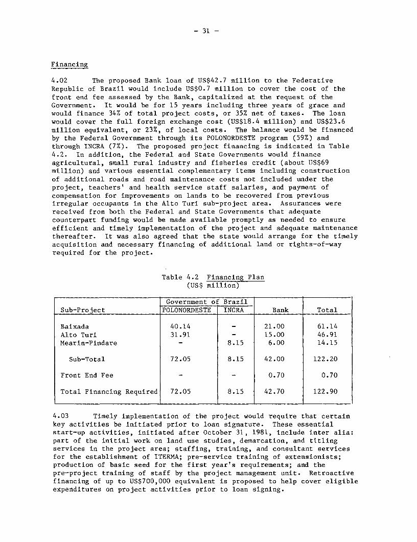
- 31 -
Financing
4.02 The proposed Bank loan of US$42.7 million to the FederativeRepublic of Brazil would include US$0.7 million to cover the cost of thefront end fee assessed by the Bank, capitalized at the request of theGovernment. It would be for 15 years including three years of grace andwould finance 34% of total project costs, or 35% net of taxes. The loanwould cover the full foreign exchange cost (US$18.4 million) and US$23.6million equivalent, or 23%, of local costs. The balance would be financedby the Federal Government through its POLONORDESTE program (59%) andthrough INCRA (7%). The proposed project financing is indicated in Table4.2. In addition, the Federal and State Governments would financeagricultural, small rural industry and fisheries credit (about US$69million) and various essential complementary items including constructionof additional roads and road maintenance costs not included under theproject, teachers' and health service staff salaries, and payment ofcompensation for improvements on lands to be recovered from previousirregular occupants in the Alto Turi sub-project area. Assurances werereceived from both the Federal and State Governments that adequatecounterpart funding would be made available promptly as needed to ensureefficient and timely implementation of the project and adequate maintenancethereafter. It was also agreed that the state would arrange for the timelyacquisition and necessary financing of additional land or rights-of-wayrequired for the project.
Table 4.2 Financing Plan(US$ million)
Government of BrazilSub-Project POLONORDESTE INCRA Bank Total
Baixada 40.14 _ 21.00 61.14
Alto Turi 31.91 - 15.00 46.91
Mearim-Pindare _ 8.15 6.00 14.15
Sub-Total 72.05 8.15 42.00 122.20
Front End Fee - _ 0.70 0.70
Total Financing Required 72.05 8.15 42.70 122.90
4.03 Timely implementation of the project would require that certainkey activities be initiated prior to loan signature. These essentialstart-up activities, initiated after October 31, 1981, include inter alia:part of the initial work on land use studies, demarcation, and titlingservices in the project area; staffing, training, and consultant servicesfor the establishment of ITERMA; pre-service training of extensionists;production of basic seed for the first year's requirements; and thepre-project training of staff by the project management unit. Retroactivefinancing of up to US$700,000 equivalent is proposed to help cover eligibleexpenditures on project activities prior to loan signing.

- 32 -
Procurement
4.04 Farm inputs and equipment for small scale enterprises andfisheries would be procured by individual producers through local tradechannels or through the state input supply agencies. Civil works (aboutUS$19 million, excluding contingencies) associated with the rural transportcomponent would be procured following local competitive bidding procedureswith construction packages sized to allow bids from small and mediumcontractors. Although the bidding procedures do not exclude foreign firms,it is anticipated that none are likely to be interested given the size,nature and remoteness of the works. Brazil's construction industry iscompetitive and capable of carrying out such works. Civil works involvingthe construction of offices, research facilities, storage units, schools,health posts and water supply facilities would be geographically dispersed,individually small, and phased over time. Such works (totalling about US$7million) would largely be executed under contracts awarded following localcompetitive bidding although some of these works (about 20%) would beexecuted by a combination of force account and self-help. Most of thevehicles (US$2 million) and materials and equipment (US$5 million) requiredfor the various project executing agencies are locally produced and readilyavailable and would be procured over the project period by the respectiveagencies following local procurement procedures which are acceptable.Various services such as cadastral surveys and demarcation (US$13 million)associated with the land component would be procured following localcompetitive bidding procedures with contracts packaged to allow bids fromsmall and medium contractors. Finally, the various technical assistanceconsultancy services (US$1 million) would include a total of about 16manyears at an anticipated cost ranging from US$1,500 to US$7,000 permanmonth. About 45% of such services would be for technical andadministrative aspects of the land component which could be carried out bylocal or foreign consultants while the balance would be smaller, scatteredassignments to largely local consultancies for various aspects of projectadministration, health administration, marketing, forestry, fisheries andsmall scale enterprise development. Assurances were received from theFederal and State Governments and COLONE that consultants would all becontracted on terms and conditions satisfactory to the Bank.
Disbursements
4.05 The proceeds of the proposed loan would be disbursed against allproject expenditures except compensation for improvements on landsrecovered from irregular occupiers under the land component. Thedisbursement would be equivalent to 100% of expenditures net of taxes forpriority aerial photography and photo-restitution work needed to completeland use planning within the project area prior to commencing landredistribution, and 31% of actual costs of all other eligibleexpenditures. Disbursements for works carried out by force account andoperational expenses would be made against withdrawal applications coveringstatements of expenditures initiated by the various implementing agenciesand certified by the PMU. Supporting documentation would be retained bythe agency responsible for certification and would be made available forinspection by the Bank during project review missions. Standarddocumentation covering civil works, vehicles, equipment and technical

- 33 -
assistance would be submitted through the Central Bank of Brazil to theWorld Bank.
4.06 In order to reduce the interval during which the Government wouldfinance the Bank's share of project costs with its own resources, a SpecialAccount would be opened in the Central Bank with an initial deposit of upto US$3 million. The Government may request the Bank to make advancepayments in dollars from the loan account into this Special Account.Withdrawals in cruzeiros from the account would be made on the basis of thestatements of expenditures forwarded to the Central Bank. Conversion fromdollars into cruzeiros would be made at the exchange rate that prevailed onthe date the expenditures were made. The Central Bank would send thestatements to the Bank, which would then replenish the Special Account.
4.07 Disbursements are expected to occur over about five years and theestimated disbursement schedule shown in Annex 4 reflects the disbursementprofile for previous agricultural projects in Brazil, with some adjustmentsto take into account the improvements expected from the operations of theSpecial Account, and the particular characteristics of the proposedproject, including considerable consultant studies expenses in the earlyyears. The closing date of the loan would be December 31, 1987.
V. PROJECT IMPLEMENTATION
Organization and Management
5.01 The three sub-projects would each have a separate administrationand coordination unit to allow better matching of the administrativestructure to the particular needs of the sub-project. Collaboration andcoordination between the various particiapting agencies responsible forproviding the services under the project and appropriate coordination inthe planning and execution of the three sub-projects, would be achievedthrough a Project Coordination Committee (para 5.03). The participation oftarget groups in the formulation, execution, monitoring, and evaluation ofproject activities, would be encouraged and facilitated through theproposed specialized training of participating agency staff, and throughlocation of staff in the field to maintain closer contact withbeneficiaries. Execution responsibilities have been assigned largely toexisting agencies which would be suitably strengthened under the project,and their improved functioning should generate additional benefits outsidethe project area. The proposed overall administrative structure of theproject is presented in Annex 7, Chart 1.
5.02 The State Management Council of POLONORDESTE (Conselho Diretor)would continue to function as the guiding body for all POLONORDESTEactivities within Maranhao, including the proposed project. It is chairedby the State Governor with the State Secretary of Planning as the executivesecretary. It also comprises the Secretaries of Planning, Agriculture,Interior, Finance, Transport, Education, Health, the President of COLONE,and representatives of INCRA, the Ministry of Agriculture, SUDENE, Bank of

- 34 -
Brazil and other collaborating banks. The state POLONORDESTE Coordinatorparticipates as an advisor to the Council. The Council meets quarterly inaddition to extraordinary meetings as required.
5.03 The Project Coordination Committee would be the key forum forcoordinating of the project and would consist of senior representatives ofeach executing agency, the project managers for each sub-project, and thestate POLONORDESTE Coordinator who would serve as the executive secretaryof the Committee. It would normally meet bi-monthly with the Secretary ofPlanning as chairman. Its routine functions would include review ofmonitoring information and agreement on appropriate responses, discussionand planning of operational details to integrate services from involvedagencies, and development of operational procedures to respond todirectives from the State Management Council. In addition, the committeewould meet as required to deal with implementation problems involvinginter-relationships between executing agencies and to review draft annualoperating plans for consistency and integration.
5.04 Project Management Units (PMU) would be responsible for theday-to-day coordination, administration and monitoring of eachsub-project. The PMU for the Baixada sub-project would come under thedirect administrative responsibility of the state's POLONORDESTECoordinator and would be one of three such units within the POLONORDESTETechnical Unit (TU) in the State's Secretariat of Planning.4 / The internalstructure of the Baixada PMU is presented in Annex 7, Chart 2. It would beheaded by a Project Manager and would comprise: two headquarters sections,(an administration, accounts, and support section, AASS, and an operationsmonitoring, ongoing evaluation and planning section, MEPS); and a FieldUnit in Pinheiro with a Coordinator, five Field Monitors, andadministrative support staff and drivers. The headquarters operationssection (MEPS) would be headed by an Operations Coordinator supported byfive technical specialists (for land activities, community development,production services, infrastructure, and social services). The five FieldMonitors would have specializations matching their head officecounterparts. The technical specialists, both in the field office and inheadquarters, would function by maintaining close and continued contactswith the executing agencies, each of which would nominate a specificLiaison Officer for the project. The technical specialists would reporttheir monitoring findings in the form of monthly and quarterly progressreports in addition to ad hoc reports on problems and special studies.They would also assist in project evaluation activities although most ofthis work would be carried out by an external evaluation group (para5.13). The Field Coordinator would be the local representative of theProject Manager and, apart from supervising the Field Monitors, wouldestablish and maintain contacts with municipal authorities and beneficiarygroupings, including rural labor unions, churches, social groups andcommunity leaders. The Field Monitors would travel extensively spendingtime with beneficiaries and collecting both formal and informal monitoringinformation. The field staff would share office accomodation with otherexecuting agencies.
4/ The other two units coordinate on-going POLONORDESTE projects in the
Baixo Parnaiba and the Vale do Medio Mearim.

- 35 -
5.05 The PMU for the Alto Turi sub-project would have similar internalstructure and staffing as the Baixada PMU, but its staff would be employeesof COLONE and report to the President of COLONE. Copies of progress andother special reports would be provided to the POLONORDESTE Coordinator inaddition to SUDENE. COLONE would focus on coordinating activities"sub-contracted" out to state and other participating agencies rather thandirect execution of works itself. The PMU for the Alto Turi sub-projectwould form an integral part of COLONE's overall administration which wouldhave continued responsibilities associated with the maintenance ofactivities initiated under the first Alto Turi project in addition toactivities in land regularization, initial extension services for newsettlers, input supply, contracting construction of schools, roads andother works in new settlement areas, and collaboration in studies andtechnical assistance for small scale enterprises under the proposedsub-project. Assurances were received that COLONE would employ consultantsby September 30, 1982 to prepare a proposal and assist in implementation ofa reorganization plan consistent with project and COLONE objectives, andwould furnish this plan to the Bank by March 31, 1983, for review andcomment.
5.06 Arrangements for the coordination and management of theMearim-Pindare land regularization and redistribution sub-project, reflectthe distribution of responsibilities between INCRA and ITERMA. As the leadexecuting agency, INCRA would be responsible for the day-to-dayadministration of the sub-project establishing for this purpose a smallmanagement unit in line with its normal procedures. ITERMA's PlanningDivision (see Annex 1, Chart 1) would collaborate with the staff of theINCRA management unit in the preparation of annual operating plans and thereview of performance as well as arranging for the participation of ITERMAstaff in selected implementation activities. This division would receiveall reports from INCRA and would be responsible for liaison with thePOLONORDESTE management unit for the on-going Vale do Medio Mearim projectto facilitate coordination of the development activities under that projectwith the land activities included under the proposed project.
5.07 Assurances were receiuved that: (a) all project managementunits would be appropriately staffed by September 30, 1982 and theirstaffing adequately maintained for the duration of the project; and (b) theProject Managers and Field Coordinators would have appropriatequalifications and experience and would be appointed following exchange ofviews with the Bank.
Planning and Operating Procedures
5.08 Experience with rural development projects in Northeast Brazilhas revealed the need to incorporate mechanisms for continued review anditerative planning in the administration of such projects, to ensure thatthey are able to respond flexibly to changing circumstances. The proposedproject has specific overall targets and objectives whose achievement wouldbe pursued through detailed annual operating plans. Given the need forextensive consultations between the PMU's, the executing agencies, the

- 36 -
beneficiaries, and the local funding agencies, the annual planning exercisewould start in May for the POLONORDESTE year commencing in the followingApril. The MEPS of each PMU would prepare preliminary targets withindicative budgets for each component and would review these with theSub-Project Managers before being further discussed and developed with thestate POLONORDESTE Coordinator by early June. The staff of the MEPS wouldassist the responsible staff in each executing agency to produce finaldraft plans by September 1 of each year. These plans would then beconsolidated for each PMU and adjusted for consistency with guidelines fromthe Project Coordination Committee. Assurances were obtained that: (a)the draft annual operating plans for each sub-project would be provided tothe Bank not later than October 1 of each year and would be satisfactory tothe Bank; (b) the Bank would be provided, before the beginning of eachproject year, satisfactory final plans and opportunity to comment beforeany subsequent substantial modification of these plans.
5.09 The operating procedures through which the project would beimplemented vary somewhat by sub-project reflecting the varyingresponsibilities and modus operandi of the executing agencies. In commonwith past rural development projects, the proposed project would usewritten agreements (convenios) between the state and participating agenciesto specify the responsibilities of each party and to thus formalize whatotherwise may have been a loosely formed intention of cooperation and, inthe process, to greatly assist in integration of project activities.These convenios are listed in Annex 5. Assurances were received from theFederal and State Governments and COLONE that they would enter into andmaintain agreements satisfactory to the Bank for the duration of theproject implementation period. Signature and maintenance of suchagreements would be conditions of disbursement for the respectivecomponents.
5.10 In the Baixada sub-project, all project activities would becarried out by State agencies or private contractors acting under conveniosto the State Government through SEPLAN-MA (represented by the PHU). Forthis sub-project, ITERMA would receive technical and financial assistancefrom INCRA under the terms of an agreement. The operating procedures forthe implementation of the Alto Turi sub-project reflect the transitionalrole of the main coordination agency, COLONE, which would transferresponsibility for all project activities to appropriate state agencies orcooperatives no later than the end of the implementation period, and manymuch sooner. Project activities other than seed production, supply of somefarm inputs, initial extension activities, and contracting of works in newsettlement areas, would be carried out by the appropriate state agenciescontracted by COLONE, which would receive funds from POLONORDESTE and passthese on to the agencies for execution. COLONE would thus maintain adegree of control over settlement implementation while the state agenciesdevelop implementation expertise and take on maintenance and operationresponsibilities. Assurances have been received that COLONE would furnishto Bank, not later than July 31, 1983, a program satisfactory to the Bankfor the transfer of project-related responsibilities, facilities and staff,to the state or other appropriate entities and complete the program by June30, 1987.

- 37 -
Accounts and Auditing
5.11 Each participating agency, including the three sub-project PMU,would maintain separate accounts of its project expenditures which would beaudited annually by the Central Secretariat of Internal Control (SECIN) ofthe Federal Secretariat of Planning following standard government practicewhich is satisfactory to the Bank. The PMU would retain copies of alldocumentation of project-related statements of expenditures. Theprocedures to be used by executing agencies in preparing and verifyingstatements of expenditures were found to be satisfactory. Assurances werereceived that: (i) the audited statement of the project accounts for thethree sub-projects would be provided to the Bank within six months of theend of their fiscal year; and (ii) the audit report would contain aspecific reference as to the adequacy of the procedures used for thepreparation and verification of statements of expenditures used fordisbursement requests. The Special Account in the Central Bank would beaudited by independent auditors acceptable to the Bank.
Monitoring and Reporting
5.12 Each PMU would include an internal monitoring system to provideproject administrators with timely implementation information fordecision-making and annual planning. Monitoring activities would bedirected by the MEPS Operations Coordinators (para 5.04), supported by thetechnical specialists located at headquarters and in the field. Inaddition to information from the Field Coordinators, monitoring informationwould come from the executing agencies and beneficiaries. Whereas thefield staff would be largely concerned with collecting local levelinformation from beneficiaries and executing agencies, the headquarterlevel staff would be more concerned with the collation of information intoreports and collection of information from the executing agencies'head-offices. Standardized forms would be filled in quarterly by theexecuting agencies and submitted to the respective MEPS for consolidationinto sub-project quarterly reports. The state POLONORDESTE Coordinatorwould collate these into an overall quarterly progress report for theproject which would be distributed to the Bank, executing agencies, theState POLONORDESTE Management Council, SUDENE and to federal agencies. Thereport would document project implementation progress and expenditures withcomparisons to forecasts in Annual Operating Plans using selected keyindicators to the extent possible. A list of key indicators is presentedin Annex 6. Field staff would also submit monthly reports on a smallerselection of key indicators. In addition to their routine monitoringactivities, staff of the PMTJ's would carry out selected case studies of asmall sample of project beneficiaries to assist in problem diagnosis byproviding detailed information which may reveal causes of observeddeviations from expected results. Assurances were received that: (a)prior to September 30, 1982, the state, INCRA and COLONE would submit tothe Bank proposals outlining the procedures and reporting format to befollowed in each sub-project, and for the overall project, these proposalsto be satisfactory to the Bank; (b) the quarterly monitoring reports wouldbe provided to the Bank promptly following their completion and not laterthan three months after the close of each POLONORDESTE quarter; and (c)the Borrower would provide the Bank with a completion report not later thansix months after the Closing Date of the Loan.

- 38 -
Evaluation
5.13 The project's performance would be evaluated to determine whetherthe expected effects and impacts, implicit in the projects objectives, arebeing achieved. By their nature, these effects are lagged. The evaluationunder the project would include a longitudinal study consisting ofbaseline, mid-term and post-project surveys of about 300 producers withineach sub-project. The evaluation would be carried out by a smallindependent team including staff of the State Agricultural PlanningCommission (CEPA-MA), and the State Center for Data Processing (CETEMA).This team would receive technical assistance from UNDP which is currentlyassisting with similar work in Maranhao. The Operations Coordinators fromthe three PMUs would maintain close contacts with the evaluation team butthe team would remain administratively independent and would report to thestate POLONORDESTE Coordinator. Assurances were received that the resultsof the baseline, mid-term and post-project surveys would be provided to theBank not later than December 31, 1982, 1985 and 1987, respectively, withthe exception of the results of the baseline survey for the Mearim-Pindareto be furnished to the Bank not later than December 31, 1983.
VI. PRODUCTION, DEMAND, MARKETS AND PRICES
Agricultural Development Strategy
6.01 The primary income foundation of the project would beagriculture, and its improved productivity would be promoted in a threestage process. The first stage would be based on improvements totraditional food crops (rice, cassava, maize and cowpeas) using minimalpurchased inputs, and techniques already identified by research inMaranhao. The second stage would be based on a modest expansion of thecropped area through use of varieties which better distribute labor demand,use of herbicides to reduce the weeding constraint, use of some fertilizerto restore and maintain fertility, use of animal traction, and theintroduction on a limited scale of some new crops and livestock activities(pigs and cattle). The third stage would expand the area of the new annualand perennial crops (peanuts, banana, pineapples, other fruits, urucu,guarana, and rubber). The third stage would also involve greater use offertilizers and agricultural chemicals. The overall objective of theagricultural development strategy would be to develop a stable and moreproductive form of agriculture and would concentrate on improving soilfertility and reducing soil erosion. The adoption of new practices isexpected to be slow and it has been assumed that by year five of theproject only 10 to 15% of project farmer beneficiaries would reach thethird stage, 35 to 40% the second stage, and 50% only the first stage. Theannual phasing of project beneficiaries and the expected adoption of newtechnologies is presented in Annex 3, Table 3. Only land judged to besuitable for agriculture, based on the land use planning studies (para3.18), would be developed under the project, with parts of the remaining

- 39 -
area set aside as protected reserves. Extensionists would receive specialtraining to enable them to advise farmers how to best use their land froman ecological viewpoint, and how to use contour cropping to reduce soillosses. Further soil conservation would be brought about through theplanting of farm woodlots to supply lumber and posts.
6.02 The immediate development potential of the project areaundoubtedly lies in its upland agriculture; however, in the longer term,there is considerable potential for irrigated lowland agriculture,particularly in the Baixada. Although this irrigation potential cannotbe exploited on a large scale without the construction of extensive dikesand polders, there is scope at present for exploiting existing permanentwater sources using small pumps. In order to help introduce irrigationtechnology to small farmers and to ensure that small farmers canparticipate in the likely future exploitation of this potential, theproject would aim to assist some 500 small farmers in the Baixada indeveloping one to two ha irrigation plots through the provision oftechnical assistance by EMATER-MA, through some applied research by EMAPA,and through arrangements for the provision of credit for the purchase ofpumps. Further details of the agricultural development envisaged under theproject, including a summary of the expected costs and returns forillustrative farm models, are presented in Annexes 2 and 3.
Production
6.03 The proposed project activities are expected to lead tosignificant increases in agricultural production as well as modestincreases in output from small scale enterprises and fisheries. By fulldevelopment (year 10), the annual value of incremental crop production isprojected at US$40 million equivalent in 1981 prices. This productionincrease would be derived, roughly, from: an increase in area planted (byabout 30%), reflecting inter alia changes in land tenure, use of animaltraction, and expanded marketing opportunities; gradual increases in cropyields resulting from the use of improved seeds, selected labor-saving andyield-enhancing inputs, and from the adoption of better cultural practices;some introduction of new crops such as rubber, banana, guarana, urucu,peanuts, sugarcane and pineapple (which together are expected to accountfor about 29% of the increase in cropped area); and from improvements inlabor productivity owing to the removal of non-productive tasks associatedwith annual fencing on rented land, to the adoption of cropping systemswhich spread labor demand more evenly, and to the use of labor-savinginputs, notably animal traction. The project would also generate annualincremental livestock production valued at roughly US$2 million at fulldevelopment through the introduction of small cattle herds (or comparablelivestock activities) on about 13% of the beneficiary farms as part of anoverall crop rotation scheme which would include a pasture phase.
6.04 The contribution of various commodities to the value ofincremental production at full development is estimated as follows:cassava, 40%; rice, 17%; beans, 3%; rubber, 9%; and bananas, pineapples orother alternative high-value new crops, 30%. The incremental output fromproject assisted small scale enterprises is estimated at about US$0.4million annually. The expected contribution of increased fish production

- 40 -
to incremental project production has not been estimated owing to the pilotnature of the operation and the need for further work to identify the mostfruitful methods of improved production and productivity. Although someproject beneficiaries are expected to develop small scale irrigationenterprises based on the use of low lift pumps and permanent natural watersources, no specific estimates of the value of such increased productionhas been made. Vegetables, including tomatoes, would form the major outputfrom such irrigation enterprises.
Demand, Markets and Prices
6.05 Incremental project production would be relatively insignificantin relation to total production in the state and none of the products areexpected to be subject to demand contraints, given Brazil's periodicshortages of food crops. Table 6.1 indicates current state production ofmajor project crops and the projected project area production with andwithout the project.
Table 6.1 Relative Production Share of Project Beneficiaries
Estimated Project Beneficiaries EstimatedCurrent State Production Share of Current State Production (%)
('000 tons) Without Project With Project
Rice 1,281 6 9Cassava 2,616 4 6Maize 237 4 7Beans 44 13 17
Maranhao produces about 15% of Brazil's rice; incremental production wouldbe sold within Brazil, where there is a ready market, or exported. Cassavais a major export from Maranhao to other parts of Brazil, and a main sourceof food energy for the low income population of the project area and theNortheast. Although the low price-elasticity of demand for cassavaindicates that significant increase in supply would lead to lower prices,the projected incremental project production is not expected to be ofsufficient magnitude to have a significant effect. Cassava and rice wouldbe marketed through the traditional marketing channels and throughcooperatives, both to be strengthened under the project. Incrementalproduction of maize and beans (cowpeas) would be marketed and consumedlocally. Rubber would be not be produced for some six to eight yearsduring which time marketing channels would be developed. The demand fornatural rubber is strong since all output would be used in Brazil, whichis a substantial net importer. Beef, milk, and other animal productsproduced under the project, would be marketed within the project area or inSao Luis where there is a strong demand. Although the representativeproduction models (para 7.01) include for illustrative purposes only threeother new crops, it is expected that a wide range of crops would be grownin response to market prospects. Bananas and pineapples would be marketedlocally as fresh fruit. Guarana (a beverage base native to the area),urucu (a red vegetable food coloring agent), and passionfruit would be sold

- 41 -
for consumption in Brazil, or for export. Although the project's cropoutput is not expected to face demand limitations, several products wouldbenefit from market development efforts, and the State's MarketingCommission within the Secretariat of Agriculture would assist in thisfunction.
VII. FINANCIAL ANALYSIS
Illustrative Farm Models
7.01 The impact of the proposed changes in on-farm practices onproducer costs and incomes were analyzed using 11 illustrative farm modelsto illustrate the probable range of incomes consistent with resourceavailabilities and likely beneficiary adoption rates. Details of theassumptions used in the models are presented in Annex 3. The keycharacteristics of the farm models together with the number of farmersexpected to be roughly represented by the various models is presented inAnnex 3, Table 1. The without project situation reflects present practicesin the project area and its future projection is based on maintenance ofcurrent cropped area and yields. Each of the models reflect fundamentalchanges in farm input-output relationships expected to be generated by theproject-induced change to a more secure form of land tenure. For one ofthe models (D), these are the only changes from the without projectsituation. The changes expected to result from more secure land accessinclude: (i) an increase in labor availability resulting from the removalof the necessity to construct fences annually around the cropped area; and(ii) small (around 15%) increases in cropped area made possible by theadditional labor available as a result of (i). The models A/L and B/L forboth the Baixada and Alto Turi, illustrate the situation where projectbeneficiaries choose to develop livestock enterprises rather thanestablishing new crops. The analysis has been based on cattle, althoughsheep, goats, or swine would be less capital intensive and somewhat moreprofitable.
7.02 The estimated financial rates of return after financing rangefrom about 32% to greater than 50%. In all cases however, since theexpected levels of on-farm investment are low, this indicator is felt to beof little value as an indicator of the attractiveness of the proposeddevelopments to small farmers. Possibly more appropriate indicators arethe Net Income Increase (NII) and the net return per workday at fulldevelopment. Values for these indicators are presented in Table 1,Annex 3. With the NII ranging from 11% to 255%, all models are expected toprovide adequate incentives to producers; however, only the moreprogressive and less risk-averse farmers are expected to reach the highertechnology levels implicit in models A and B. The farm budgets used tocalculate these values include on-farm investments (land clearing, fencing,perennial crop establishment, draft animal and equipment purchases, otherlivestock and tools), and crop operating and maintenance costs includingseeds, fertilizer, other agricultural chemicals and hired labor. Pricesfor inputs and outputs were based on prices prevailing in August 1981 withadjustments for seasonal variations and are summarized in Annex 7, Table 6.

- 42 -
Farm Producer Income
7.03 The project farm family beneficiaries are estimated to havecurrent family incomes in the range of US$900-1,300 in 1981, equivalent toa per capita income of US$150-220 for a family of six. This isconsiderably below Brazil's rural poverty level of US$330 per capita. Atfull development, the weighted average per capita income is expected toreach US$1,937 (in 1981 dollars) for participating farm families, anincrease of some 67% over the pre-project situation. The returns to familylabor would increase on average about 36%. Despite these substantialimprovements, at the end of the project implementation period, only about17% of project beneficiaries would have incomes above Brazil's relativepoverty level. It is, however, anticipated that the provision of research,extension and marketing services after the five year implementation period,would result in continued improvement in the productivity of thosebeneficiaries making only minimal changes during the first five years.Hence, it can be reasonably expected that most beneficiaries would haveincomes exceeding the rural poverty level within ten years. In practice,there is expected to be a significant range of incomes reflecting interalia the individual farmer's choices both to the type of crops and to thearea cultivated. The estimated farm family income from agriculturalactivities is summarized in Annex 7, Table 7.
Small Scale Enterprises
7.04 The project would support a number of small scale enterpriseswhich are important in providing off-farm employment and in generatinglocal value added. These enterprises are involved in the processing ofagricultural products and in the manufacture of tiles, furniture, hammocksand various textiles. The project would provide technical assistance tosuch enterprises resulting in estimated rates of return ranging from 20% toover 50%. An illustrative model is presented in Annex 7, Table 4.
Fiscal Impact
7.05 The costs of project investments per benefitting family wouldrange from US$5,800 for families receiving full production and socialservices together with titled re-distributed state land, to US$730 forfamilies receiving only land regularization services. It is not theGovernment's policy to require full cost recovery for production supportservices or rural infrastructure investments directed towards low-incomefamilies. However, the state's existing fiscal devices could raisesufficient revenues to offset, not only the incremental recurrent costs,but also a share of the investment costs. The marketing tax (ICM), leviedon incremental marketed production, could generate some US$4.9 millionannually by full development compared to project-related recurrent costs ofabout US$3.0 million. Rural social security revenue (FUNRURAL), levied at2.5% on the value of incremental marketed production, would provide afurther US$1.0 million at full development. Furthermore, road maintenancecosts would be recovered through the various license fees, road usercharges and taxes. Water supply systems would be largely maintained by the

- 43 -
communities through user associations and user charges. Land beneficiarieswould be required to contribute towards the costs of land they receive inaddition to payments of land tax (ITR) which could generate about US$2million annually, further improving the fiscal impact of the project. Theoverall level of cost recovery is difficult to estimate however, in view ofthe judgements which must be made about the efficiency with which existingfiscal devices would be applied. To help reduce the risk ofdiscontinuities in financing, responsibilities for operation andmaintenance for each component would be subject to commitments in theoperating agreements between participating entities (para 5.09).
VIII. ECONOMIC BENEFITS AND JUSTIFICATIONS
Economic Rate of Return
8.01 The estimated economic benefits from those aspects of theproject with quantifiable returns, whose costs total some 78% of theoverall project costs, generate an overall economic rate of return estimateof 22%. Various aspects of the project, such as the health, rural watersupply, and education components, would have an important impact onimproving living conditions but since their benefits are not readilyquantifiable, their costs were excluded from the economic rate of returncalculation. Also, the costs and benefits of the forestry and fisheriescomponents, both of a pilot nature and with benefits difficult tomeaningfully quantify at this stage, were not included.
8.02 The costs used in estimating the economic rate of returnincluded: (i) all farm and small scale enterprise investments andincremental operating costs; (ii) all off-farm investment and incrementaloperating costs directly related to production development during theproject period; and (iii) recurrent costs of services, infrastructure andof certain project services (e.g., extension, marketing, research), whichwould be necessary post-project to sustain the projected development. Inrespect to "off-farm" investment, the cost-stream included: 100% of theproject costs (baseline plus physical contingencies) for landregularization activities, research and seeds, marketing and input supply,roads, and cooperative development; 60% of the land related studies (sincethe results of the studies would be used extensively also for subsequentregional development and infrastructure planning); 75% of rural extensionservice costs (since part of the rural extension services are directly orindirectly related to social development activities); 90% of costs foradministration and monitoring (since part of these costs are related tosocial activities of the project); and 50% of the costs of evaluationcomponent (since lessons learned from the evaluation would benefit mainlysubsequent projects).
8.03 The benefit stream used in the economic rate of return analysisincludes all of the incremental production above the "without project"situation of the farmers who are expected to receive direct technical

- 44 -
assistance through the project. The benefit stream includes onlyconservative estimates of the benefits derived from increased agriculturalproduction resulting from the more secure land tenure situation which wouldbe created. It does not take into account increases in agriculturalproduction to be achieved by rural producers not included in the group ofdirect project beneficiaries. Such increases would hopefully occur as aresult of the demonstration effects of the agricultural extension andresearch programs, through the participation of non-project beneficiariesin the improved input supply and cooperative system, and through use of theimproved storage facilities. The road-user savings from the improved roadsystem (benefitting whole population by improving access to services, andfacilitating and reducing the cost of transporting inputs and outputs) werenot quantified. The details of the cost and benefit streams used in theeconomic analysis are presented in Annex 7, Table 8.
8.04 The prices used in the economic analysis for those goods tradedon the international market are border prices adjusted to take into accountquality differentials and farm-to-border transportation costs. Tradedgoods include rice, rubber and beef. Brazil is a net exporter of rice,although it occasionally imports small quantities; it is a net importer ofnatural rubber, and a small net importer of beef. Non-traded goods werevalued at local farmgate prices. They include: beans, which are consumedentirely locally and are of a lower quality than those traded in Brazil;maize, which is consumed locally, mainly as a livestock feed; cassavaflour, which is consumed locally and exported to other parts of Brazil; andbanana and pineapple, which are consumed locally and are generally of alower quality than those traded in Brazil. The prices of these non-tradedcommodities are expected to remain stable or to increase only slightly overthe next decade. Labor was valued at a seasonally adjusted wage rateranging from 60-100% of the peak market value, in order to reflect theprevailing unemployment and underemployment in the project area. Detailsof the prices used in the economic analysis are given in Annex 7, Table 6.In arriving at the border prices and in deriving economic values forproject costs, the foreign exchange component expressed in local currencywas revalued by 20% to reflect trade distorting tariffs, subsidies, advanceimport deposits, export taxes and quantitative restrictions.
8.05 To measure the impact of possible changes in the economicenvironment on the project's stream of costs and benefits, a range ofsensitivity tests were performed. The results of the most significant onesare as follows:
Table 8.1 Sensitivity Test Results on InternalEconomic Rate of Return
Best Estimate: 22% Benefits lag 2 years: 16%Costs up by 20%: 18% Costs up 10%,Project Benefits benefits down 10%: 18%down by 20%: 18% Costs up 20%,
project benefits down 20% 14%

- 45 -
8.06 The overall project exhibits a moderate but acceptable degree ofsensitivity to possible variations in key parameters as shown in Table 8.1.A 20% reduction in the value of the already conservatively estimatedincremental production, would decrease the return to about 18%. However,even with a 20% cost overrun, and a 20% decrease in project benefits, thereturn would be 14%. Analysis of switching values reveals that the projectbenefits would need to fall 41%, or the project costs to rise 68%, to bringthe return down to a 12% opportunity cost of capital.
Employment
8.07 The project would provide additional agricultural employmentequivalent to about 11,000 worker-years at full development. Some 85% ofthis increment would be provided by family labor with the balance met byhiring. This substantial demand for labor, together with the improvedprofitability of farming operations, part of which could be passed on toemployees in the form of higher wages, should significantly reduce thecurrent trend of emigration from the project area. Additional employmentwould be generated in the processing, marketing, and service industries asa result of increased agricultural input demand and production. Projectassistance to some 650 small scale enterprises is expected to generateabout 1,000 new jobs by full development.
Environmental Impact
8.08 The project would have a significant beneficial impact on theproject area environment. The project-sponsored land use studies shouldlead to more rational use of the project area resources both at a regionallevel and within farms. The areas found to be unsuitable for agriculturewould be protected and/or eventually reforested, thus reducing soil erosionin watersheds and siltation in watercourses. The gradual shift from slashand burn agriculture to sedentary cultivation incorporating crop rotationsand restoration of fertility through use of fertilizers, would helpstabilize land use whilst generating greater incomes. The change to securetenure in itself could be expected to lead to more careful stewardship ofthe natural resources. Within the farms, the encouragement of practicessuch as contour farming, rotation of crops with pasture including legumes,and the establishment of farm woodlots, all would contribute toenvironmental protection, though it must be accepted that their adoptionwould be slow. Although the project would encourage use of inorganic andorganic fertilizers, the levels of application would be so low in relationto plant needs, as to avoid significant runoff losses. The envisagedminimal herbicide use under the project would be carefully monitored byEMATER-MA extensionists and its use tested by EMAPA prior torecommendation.
Impact on Women
8.09 Women contribute significantly to the project area workforcebeing involved in all but the heaviest agricultural operations in additionto substantial off-farm work, most notably, the collection and breaking ofthe nut from the babassu palm. Nonetheless, they receive lower wages thanmen and remain limited in their employment opportunities. The project

- 46 -
would provide women with expanded employment opportunities on family farms,both in terms of time and quality of work. To a lesser extent, through itssmall scale enterprise component and through its generated demand for hiredlabor, the project would provide greater off-farm employment for women.The impact of this would be monitored as part of the overall project bothby analyzing women's participation in project activities and by trying toassess changes in earnings and employment. In general, women in theexecuting agencies were actively involved in the preparation of the projectand would continue this involvement in execution.
Project Risks
8.10 The proposed project represents an ambitious attempt to redresssome of the most obstinate and long-standing constraints to the developmentof a significant portion of the rural popultion of one of the leastdeveloped states in Northeast Brazil. The constraints involved--landtenure, infrastructure, support services and economic options--reflect notonly scarcity of financial resources, inadequate staffing andadministration of service agencies, and mediocre resource endowments of thearea, but also long-established political and cultural traditions inimicalto change. Thus, perhaps the greatest risk the project faces is thepossibility that the State will not be able to sustain its determination tobring change to those political and cultural traditions which have hamperedeffective small farmer development. Problems of this nature cannot beavoided in view of recurring changes in administration; however, the riskhas been minimized firstly by trying to ensure that the project reflectedthe State's own desires and self-assessment of what would be feasible, andsecondly, by trying to ensure that some of the most politically sensitiveland-related decisions were taken prior to project start-up, thus givingtangible evidence of the State's commitment to the project.
8.11 The remaining problems which the project would face are no lessserious but can be more readily addressed by project design and are commonto most rural development projects in Brazil. Firstly, there is a riskthat the project would overload the administrative capacity of the State.This should be partly offset by the establishment of separateadministration units for the three relatively discreet sub-projects suchthat the workload of each is reasonably balanced. Although this solutionpotentially weakens overall project coordination, the use of State-levelrural development program coordinating mechanisms will lessen thistendency. The provision of technical assistance by consultants and variouscollaborating federal agencies will further reduce the administrativeburden by avoiding the need for initially large staff in some of the keyexecuting agencies. Secondly, there is the risk that there could beinadequate coordination between executing agencies, resulting in less thanoptimum complementarity of project activities and even conflicting actionsat the beneficiary level. As in other rural development projects, thisrisk would be minimized by: the functioning of the Coordinating Committeeand the Project Management Units; the designation of liaison officers ineach executing agency; the joint preparation of annual operating plans; andby the continual monitoring and evaluation of project activities. Thirdly,there is a risk that land regularization activities may be delayed withconsequent delays in other activities. This risk would be reduced by the

- 47 -
annual establishment of goals in the light to progress to date, by therequirement that annual operating plans are compatible with progress inland activities and by the provision of technical assistance to ITERMA tohelp speed implementation. In view of the crucial nature of the landinterventions, it is considered essential that these activities remain asthe pacemaker for the project even if this means some slowing of activitiesin other sectors. Fourthly, there is the risk that farmers will not adoptthe new practices proposed, either because they remain unaware of thepossibilities or because they are not perceived as sufficientlyprofitable. This risk has been addressed by giving particular emphasis tothe strengthening of the extension service and research agency, and byimproving marketing opportunities. Finally, there is the risk that projectactivities may not be adequately maintained (road maintenance may beneglected for example) during and after the implementation period. Thishas been addressed by directing specific attention to maintenanceactivities, supported by explicit assurances to be sought.
8.12 Overall, the risks associated with the proposed project areacceptable in view of the expected magnitude of project benefits and theanticipated role of the project in providing experience for similarprojects directed towards resolving the pervasive problem of insecure landtenure as a key pre-condition for productive investment in ruraldevelopment.
IX. SUMMARY OF AGREEMENTS REACHEDAND RECOMMENDATION
9.01 Assurances were obtained from the Federal Government that:
(a) it would take all necessary steps to ensure the timelyavailability of credit (para 3.44);
(b) it would take all necessary measures to protect Amerindians inthe Alto Turi and Rio Pindare reserves (para 3.45);
(c) POLONORDESTE activities under the Vale do Medio Mearim projectwould be maintained and coordinated with the proposed project(para 3.46);
(d) it would ensure timely availability of adequate counterpartfunding (para 4.02);
9.02 Assurances were obtained from the Federal Government, the Stateof Maranhao and/or COLONE that:
(a) agreements to settle the claims of irregular occupiers in AltoTuri would be reached by March 1, 1983 for sub-area I, and byDecember 31, 1983 for sub-areas II and III (para 3.13);

- 48 -
(b) the annual areas for which cadastral surveys, discriminationproceedings, and demarcation would be completed would be no lessthan agreed minima (para 3.14);
(c) land obtained as a result of the project would be used just forthe project; by November 30, 1982, a detailed plan would beprovided for interim management of land to be redistributed (para3.15);
(d) satisfactory plans would be provided for the repayment options tohelp recover costs of land services, not later than November 30,1982; the state and COLONE would, by March 31, 1983, havedeposited not less than Cr$40 million and Cr$200 millionrespectively to Land Funds for the Baixada and Alto Turi areasto meet the costs of recovering land in these areas; these landfunds would be maintained for the duration of the project; andINCRA would assure adequate funds for recovery of lands in theMearim-Pindare (para 3.16);
(e) by September 1, 1983, satisfactory detailed plans for forestreserves and for the farm woodlot scheme would be provided (para3.31);
(f) consultants would be contracted on terms and conditionssatisfactory to the Bank (para 4.04);
(g) all project management units would be staffed by September 30,1982, their staffing satisfactorily maintained for the durationof the project, and key appointments made following exchange ofviews with the Bank (para 5.07);
(h) annual operating plans satisfactory to the Bank would be providedby October 1, and the Bank would be provided, before thebeginning of each project year, satisfactory final plans andopportunity to comment on subsequent substantial modifications(para 5.08);
(i) the State, COLONE and INCRA would enter into and maintain allnecessary inter-agency agreements (para 5.09);
(j) project accounts would be satisfactorily audited (para 5.11); and
(k) satisfactory progress reporting formats would be provided bySeptember 30, 1982, and the quarterly monitoring reports and acompletion report would be provided to the Bank (para 5.12).
9.03 Assurances were obtained from COLONE that it would:
(a) by September 30, 1982, employ consultants to prepare a proposaland assist in implementation of a reorganization plan and furnishthis plan to the Bank by March 31, 1983 for review (para 5.05);
(b) provide the Bank, by July 31, 1983, satisfactory programs fortransfer of project responsibilities, facilities and staff to

- 49 -
state or other entities and complete the program by June 30, 1987(para 5.10); and
(c) collaborate with the State of Maranhao in execution of theconditions set forth in para 9.04(b), (d) and (f) below.
9.04 Assurances were obtained from the State of Maranhao that:
(a) it would ensure that ITERMA would be at all times adequatelystaffed and directed; consult with the Bank prior to changes inthe management of ITERMA; and establish and maintain acentralized cadastral record system (para 3.17);
(b) it would ensure sufficient supplies of farm inputs; the PMUswould annually provide estimates of input requirements to supplyagencies by June 30; satisfactory criteria for construction ofstorage would be specified by September 30, 1982; and COMABAwould hire a consultant by September 30, 1982 to assist inimproving its administrative capacity (para 3.29);
(c) the report on small scale industries would be provided byDecember 31, 1982 (para 3.33);
(d) before starting any project financed roadworks, DERMA wouldobtain municipal agreements to maintain such works; and the statewould construct additional roads as needed (para 3.35);
(e) road equipment procured under the project would be used only forconstruction and maintenance agreed with PMUs; DERMA wouldprovide additional equipment and support as needed, and plans forDERMA training of municipal foremen and for road maintenancewould be provided by September 30, 1982; and DERMA would assignmaintenance technicians to the project area and, by March 31,1983, would prepare a program to strengthen its overallmaintenance capacity (para 3.36);
(f) schools would be constructed at sites selected with criteriasatisfactory to the Bank, after presentation of adequate siteplans and evidence that the site had been acquired, and after theState had secured municipal agreement on employment of trainedteachers and payment of adequate salaries; and the new curriculumwould be adopted not later than the school year starting in 1984(paras 3.38 and 3.39);
(g) consultants would be appointed by September 30, 1982 on healthservice administration; the Bank would be provided with theconsultant recommendation by March 31, 1983, and the state wouldimplement the agreed recommendations by June 30, 1983 (para3.41);
(h) water systems would be installed after arrangements were madewith benefitting communities for their maintenance, and the Statewould evaluate these systems and submit its findings by March 31,1984 (para 3.42);

- 50 -
(i) it would establish a Project Credit Statistics and MonitoringSystem by April 1, 1983 and would provide by June 30 annualevaluations of the credit activities (para 3.44);
(j) it would provide support services and rural infrastructure in theMearim-Pindare sub-project area (para 3.46);
(k) it would arrange for adequate counterpart funding, operation andmaintenance, and the timely acquisition and necessary financingof additional land or rights-of-way required (para 4.02); and
(1) the results of the baseline, mid-term and post-project evaluationsurveys would be provided not later than December 31, 1982, 1985,and 1987, respectively, except for the results of the baselinesurvey of the Mearim-Pindare which would be provided by December31, 1983 (para 5.13).
9.05 Conditions of disbursement would be that: for the healthcomponent, the State Health Secretariat had completed the staffing ofexisting regional offices and health units, and diagnostic facilities forleprosy and tuberculosis had been established in the Baixada (para 3.41);and, for all components, the respective written agreements betweenexecuting agencies were in effect (para 5.09).
9.06 Conditions of loan effectiveness would be that an area of atleast 10,000 ha including that of at least three of the fifteen largestplots irregularly occupied in the Alto Turi area had been recovered interms satisfactory to the Bank (para 3.13) and that the Land Funds for theBaixada and Alto Turi sub-projects had been established with appropriateinitial deposits (para 3.16).
9.07 With these assurances and conditions, the proposed project wouldbe suitable for a Bank loan of US$42.7 million equivalent. The term wouldbe for 15 years including a three year grace period.

- 51 - APPENDIXPage 1
NORTHEAST BRAZIL
MARANHAO RURAL DEVELOPMENT PROJECT
List of Documents Available in Project File
A. Background Material
A.1 State Preparation Group Proposals.A.2 Sinopse Estatistica dos Municipios - Maranhao 1979 (SEPLAN-MA).A.3 Indicadores Economicos - 1980,
SISPLAN - Fundacao Instituto de Pesquisa Economicas FIPES.A.4 Baixada Occidental Maranhense - Diretrizes - 1978,
Joao Gualberto, SEPLAN-MA.A.5 Prelazia de Pinheiro, Aspectos Rurais, Vol. 6 - 1976,
Martine Droulers, SISPLAN.A.6 Shifting Agriculture, Land Gradding, and Peasant Organization on
Brazil's Northeast Frontiers: COLONE's Alto Turi Project and theBaixada Occidental in the State of Maranhao. Judith Tendler(consultant), 1980.
A.7 Project Completion Report - Alto Turi Land Settlement Project,Loan 853-BR, July 1981 (World Bank Document).
A.8 Projeto de Colonizacao do Alto Turi PCAT, "A Agricultura na AreaPCAT", Jose Alencar Carneiro de Freitas, SUDENE, 1970.
A.9 Comportamento de Alguns Clones de Hevea, em Acailandia, na RegiaoPre-Amazonica Maranhense (Dados Preliminares).
A.10 Land Tenure and Productivity in Maranhao. Some EmpiricalEvidence. John Strasma (consultant), 1981.
B. Staff Working Papers
B.1 Agricultural Development.B.2 Land Component.B.3 Marketing, Input Supply and Cooperatives.B.4 Inland Fisheries.B.5 Forestry Development.B.6 Small Scale Enterprises.B.7 Rural Transport.B.8 Education.B.9 Health and Water Supply.B.10 Component Costs and Phasing.B.11 Economic Analysis.

APPENDIX- 52 - Page 2
C. Documents Received During Negotiations
C.1 Act creating ITERMA (Lei No. 4353, de 9 de Novembro de 1981, Criao Instituto de Colonizacao e Terras do Maranhao - ITERMA) inDiario Oficial, Estado do Maranhao, Sao Luis, 24 de Novembro,1981.
C.2 Act governing the regulation of ITERMA (Lei 4408 de 19 de Abrilde 1982, Altera a estrutura organizacional basica do Instituto deColoniza§ao e Terras do Maranhao - ITERMA).
C.3 Draft convenio between INCRA and the State for the land componentin the Baixada sub-project.
C.4 Draft convenio between INCRA and COLONE for the land component inthe Alto Turi sub-project.
C.5 Draft convenio between INCRA and the State for the land componentin the Mearim-Pindare sub-project.
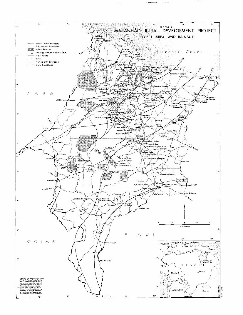
48' ' 4 V 4'i 44' 43' 42-BRAZIL
CJ-V&/ MARANHAO RURAL DEVELOPMENT PROJECTG7-'H.d. oj,<-'f 7V PROJECT AREA AND RAINFALL
Project Area Boundory ' ., K aSub-project Boundaries u B,c
5ri -
LI Indian Reserves CAuerage Annual Rainfall rsa &n C BA IXA A /a. / ,6 ,a/2
2- Main Roads / -J , 2'B ivers ,Sisb -r^a at . GU!cuinaaa
- - Municipality Boundaries . HelenaState Boundaries " to' V CD I
4,000 O= t CXX med
9caurara t ..saz > ffi<d,cn. e
5' ~ ~ / .'- uSiInd 4/ A44B0A 5'rP r n G U/ le= l=
54 / X b (E/d,= f i < - .g CA=/ oorpk/5
i A -12~~~~~~~~~~~~~~~~ .
3°>>\; g J $ *8 t vz X 'Aa g sPa5oe rnaia Ž020
ma nay Oar(. linjt c-uru SaaoirOa /dvof ,5
a' '~ ha r-nO/.. rr-u=On pu urO1ngndmn/ On 4/.Y A.
sk iSt L. T
i I | tV EJt P , fk ~~~~~...,
9't teitty are atotnttr Io S yrau
us' ~ ~ ~ ~ S 4/ 44 BOeuouA 'A.5,i
ihisAfph bf pr4s afDVth \ . s - /U /~~~~~~~~~~~~~~~~~~~~~~~~~~~~~~~~~~~~~~~~~~~~~~; -- e (\ \ } O | u) ?2 j in _~~~~~~~~~~~~~~~~~~~~~~~A,h.
woratneodwsefdAps m '.\ o | -ARENINA, OI-dE- C
0/ DCC p(d ce of SUch tf undanes ~ ~ ~ ~ ~ ~ ~ i; L 3--t ge* m CL 4do 47- 4f ' 7-' \ 45' 44' 2 \ zURUGUAf y2, _O


IBRD 16152BRAZiL 470 4t° 4odofredo5 440
7VENEZUEL .g- R.G IANA DECEMBER 1981
MARANH 0A RURAL CarutZoIrdored COLMBI URAloni/ Ocn/anticMARANHAO RURAL P~~~~~/ omin9e /AOO Area a/ Map
DEVELOPMENT PROJECT Mens Turjou Ocean _
POPULATION DENSITY Bacuri
AND PROJECT WORKS 'cururupu A B R MARANHAO
Project Area Boundary / c-me MirinzolA 2 U-- Sub-project Boundaries :rai\? Sano Hele A BAt XADA -uImrBes:
A Agricultural Services Offices - Lchrecl2z - BOLIVIA ®Brasilla
* Proposed Research Substations A L T 0 -cl ' euimao A c0Alcontora Paco 1
Sub- *A LUI~~r,fNLuia* Existing Research Substations - 2 PihLes ir Cl N L SA 0
-'.---Rivers '.-J raPalmeircrtipaiaMunicipality Boundaries Bn.oSta. za4A \ BS%O /°tu
State Boundaries *NovR Olinda0A d ARA ENSEA 7aOC -~~~~~~Araguano a cntdeerr 0 Cao' osaro MOrros0ICENlN , ~Ala o OceanA ~~~~~~0Sao- Joei Bd~lsta'anto
-3t Rural Population Density * *, S&OJOooBata0k Rita0 3°0
1-5 Persons per sq. km. Su-,eo
610 ZeD 0 0 < eav 0Vi.n naiub 0Pe.Juscelino do 4'30 4'20
11-20 21 A 50 It~e~uru rim SoS Benedit o do Ro Preto Benorador 0over 50 M V1t13/I~~~~~~~~~~~ ~ ~~~~~~~~ ~~~~~~~OAo tapro ur Varg~ 0Ninc Rodrigues 0~auei ootSo In Canto hnde0 Groede Rornoaglhaes /
~~~~~~21- 50 I onJri 0 oncoo0 AAl ogmMoo nprsmeidaver 50 { Borri Jardim° ,,tre im ; Canta hedeO \ Varaem Mata° A ~~~ri Santa Ouiteria do Maranhdo
S rines PtXv '| windare Chopadinhao Brejo° 4
°50 100 150 t 0, ,oP Xll,I-
-4 KILOMETERS 150 Altannira da 0Pa MIO 0 Lo2o,erdeS Mafeus CooooBuri 0 / 4,
. .? & - ^ J Wo~~~~ ~ ~ ~~~~~~~~~~~~~~~~roata .~0 do PMSo RO m - - MEARIM - - SkTimbiros Aue0sM-Coelho Neto
,0) Par~~~~~~~~~oRamos Lo~~~~~~~~go do OS. Luis Tranogo
/ Llogo do Pedro° .Junco0 . SIrrja Campos odo
/. ........ arape Grande, 0Pedreirs Adeis Altas.
0 Pcode Pedras
Assailondia Esperdrii7apolis° m A ios Lopes CoAxiasr This map has been prepared by the
-5° / 'g elardiaO Pedr° rnaot Archer World Bank's staff esclush'ely folTirri\ rhe report to which it is attached.
*Governador Eugenio Barros The denommnations used and theTuntum. Presidente DutrJ boundries shown on this map
0 ,n e Dutra do not imply, on the pert ef the/ World each an,d ts ayfil,tes, anyGroco Anontro / ~~~~~~~~~judgment'on the legal status of
0Joao Lisboa~~~~~~~~~~~~~~~~~~~~~~~~~~Grc Aah any terntor or any endorsement0 JoaoAmoaite do Barra do Cordoa or ac. eptarncoe of such bourndories.
0mmperatriz 47 Amorante o 45 5 40/3 3


r~~~a ~~45.", O
Tuiaqu, ~~~~~~~~~~~BRAZIL4 b,-~ 6 / MARANHAO
~' RURAL DEVELOPMENTPROJECT
>ik~fNAGRICULTURAL APTITUDE-~~~ * ~~~~--~~~~> ~AND RAINFALL
/ ~~~~~~Project Area Boundary"~~~~~~'~~~~~~' ~~~~Sub - poiect Boundcry
~~2 / y~~~~~~~ 4 -~~~~~~ 6 1 A ~~~~~~~~~ ~Average Annual Ra,nfou (mm.)2'00 -Municipality Baoundarres
6 / _~~~~~
7 CLASS I.L nd Aptaude Classes
S~~~oH . .~~~~~~~~.-< ~~~~~J4 7-P .d -Ž
7 ~~~-XP5"'~ n g LL-d
4 P~~~~~~~~~~~~~~~~~~~er qurmo0
, J~CLASS Z
7iSarreble for peena,smpo.d -O n ocsool o
6 .rr'X, ~~~~~~~~~~ 4 onnee]~~~~9L- u,pi and pesr-res
6 r~~~ *Penr sane> -~~~~~~~CLASS al4 0.S L.rral o arcad occenona... I orc--n acrp
6.Sro 1 ai-aairo 20orocro an oosoal0 oiae& -~~~ Scriob.o or coninew and co~~~~~~~K11 C onuTEs,oaeoclforerearn
S. Vicente ~ ~ ~ ~ ~ ~ ~ la 0 Ir abo o ocrus cdfr cisrsre
4 ~ ~ ~ ~ ~ ~ ~ ~ ~ ~~~~~~~~ r r~~aLr rl rraepolrr cerlrsrbefrrc n
-,> KILOMETERS~~~~~~~~~CLOBI
-3'00~~~~~~~~~~~~~~~~~~~~~~~~~~~~54~~~~~ ~~nO ecclcrc,crcWcanrrarrrrnrrrconooc
n-CS I cc'~~~~~~ N0~~~~~~~~~~~~~~~~~~~~ci thrpotecc rcrna -ednrocnrcrriO
6 Al JI:~~~~~~~~~~~~~~~~~~~~~~~~~~~~~~~~~~~~~~~~~ooc.rnrrorc;raaornrr.a narare Ordar rdo
yOa fotoba LO BIA AV/unrB -i. e
nn r r S O~~~~~~~~~~~alr
<Pecalpo - - ~ ~ ~ ~ ~ ~ ~ ~ .~IN