World Bank Documentdocuments.worldbank.org/curated/pt/140091468034457149/... · 2016-08-05 · E499...
132
E499 Volume 1 PUBLICWORKSDEPARTMENT GOVERNMENT OF KERALA INDIA KERALASTATE TRANSPORT PROJECT EXECUTIVE SUMMARY Elm:- ri '\P 7'"Fl rr: fyz' i * Louis Berger International, Inc. in association with: Sheladia Associates, Consulting Engineering Services (I)Ltd. Intercontinental Consultants & Technocrats Pvt Ltd. October 2001 FilE COPY Public Disclosure Authorized Public Disclosure Authorized Public Disclosure Authorized Public Disclosure Authorized Public Disclosure Authorized Public Disclosure Authorized Public Disclosure Authorized Public Disclosure Authorized
-
Upload
nguyentram -
Category
Documents
-
view
218 -
download
0
Transcript of World Bank Documentdocuments.worldbank.org/curated/pt/140091468034457149/... · 2016-08-05 · E499...

E499Volume 1
PUBLIC WORKS DEPARTMENTGOVERNMENT OF KERALA
INDIA
KERALA STATE TRANSPORT PROJECT
EXECUTIVE SUMMARY
Elm:- ri '\P 7'"Fl rr: fyz' i
* Louis Berger International, Inc.in association with:Sheladia Associates,Consulting Engineering Services (I) Ltd.Intercontinental Consultants & Technocrats Pvt Ltd.
October 2001
FilE COPY
Pub
lic D
iscl
osur
e A
utho
rized
Pub
lic D
iscl
osur
e A
utho
rized
Pub
lic D
iscl
osur
e A
utho
rized
Pub
lic D
iscl
osur
e A
utho
rized
Pub
lic D
iscl
osur
e A
utho
rized
Pub
lic D
iscl
osur
e A
utho
rized
Pub
lic D
iscl
osur
e A
utho
rized
Pub
lic D
iscl
osur
e A
utho
rized

Kerala State Transport Project Executive Summary
TABLE OF CONTENTS
1 INTRODUCTION. 4
1.1 PROJECT DESCRIPTION .. 41.2 PROJECT OBJECTIVE .. 41.3 APPLICATION OF THE WORLD BANK'S SAFEGUARDS . . 41.4 HIGHWAYS COMPONENT: PROJECT DESCRIPTON . . 5
1.4.1 Background. 51.4.2 Road Characteristics. 61.4.3 Project Location. 61.4.4 Project Activities. 61.4.5 Project Structuring - Construction Contract Packages for Improvement /
Upgradation.. 61.4.6 Project Structuring - Maintenance Roads. 7
1.5 PILOT WATERWAYS COMPONENT: PROJECT DESCRIPTION. 71.5.1 Background. 71.5.2 Project Location. 81.5.3 Project Activities ................................................... ,, 8
1 1.5.4 Project Structuring. 81.6 ENVIRONMENT & SocIAL BENEFTS . . 8
1.6.1 Accident Reduction Benefits . . . , . . . . 81.6.2 Road user benefits / environmental enhancements ...................................... 8
2 EA & SA PROCESSES ....... 9
2.1 HIGHWAYS COMPONENT: SEA, EA (PHASE I) & SA ..................9...................... ..... 9I 2.2 WATERWAYS COMPONENT: EA & SA ....... 102.3 INDEPENDENT REVIEW ........................ , ., ........ 10
2.4 GOVERNMENT OF INDIA (GOI) ENVIRONMENTAL AND SOCIAL CLEARANCES /
APPROVALS . 10
3 ENVIRONMENTAL AND SOCIAL BASELINE OF THE PROJECT . 1
3.1 HIGHWAYS COMPONENT: BASELINE SCENARIO .11
3.1.1 Climate & Temperature . I13.1.2 Physical terrain. I3.1.3 Geology .13.1.4 Soils .13.1.5 River Sand & Quarry Dust .123.1.6 Other Construction materials ., ... .. 123 . 1.7 Water Resources .123.1.8 Water Quality .123.1.9 Drainage. 1 23.1.10 Air Quality .133.1.11 Noise 333.1.12 Flora&Fauna .................. 13I 3.1.13 Cultural Resources .................... ,. 133.1.14 Paddy Fields ............ 133.1.15 Tourism .......................................... 143.1.16 D em ographic Profile of the region .143.1.17 Occupation Patterns .14
3 Louis Berger Intemational/Sheladia/CES/ICT
ll

Kerala State Transport Project Executive SummaryI3.1.18 Economy ............................................ 153.1.19 The Gulf Emigrants In Kerala's Economy ............................................ 15I 3.1.20 Social profile ............................................. 153.1.21 Literacy and Education ............................................ 153.1.22 Urbanisation Trend ............................................. 15I 3.1.23 Profile of Project affected People ............................................ 163.1.24 Family Economy/Resource Base ............................................. 163.1.25 Economic Profile ............................................ 163.1.26 Social Profile ............................................. 173.1.27 Literacy and Education Status ............................................ 183.1.28 Urbanisation ............................................ 8 l
3.2 WATERWAYS -ENVIRONMENTAL BASELINE SCENARIO . ......................................... 1 83.2.1 Physical Conditions ............................................ 183.2.2 Sediment quality ............................................. 19I 3.2.3 Water Quality ............................................ 193.2.4 Flora & Fauna ............................................ 19
3.3 WATERWAYS: SOCIAL BASELINE SCENARIO ...................................... 203.3.1 Demographic profile ............................................ 203.3.2 Socio-economic Profile ............................................ 20
4 PUBLIC CONSULTATION ............................................ 22
4.1 PUBLIC CONSULTATIONS ............................................ 224.2 PLAN FOR CONTINUED PARTICIPATION .................. ......................... 29
4.2.1 Responsibility for continued consultations ............................................ 29* 4.2.2 Suggestions for Future Consultation ............................................. 29
4.2.3 Follow-up Consultations ............................................ 304.2.4 Public Disclosure ............................................. 30
5 ANALYSIS OF ALTERNATIVES ............................................ 30
5.1 HIGHWAYS COMPONENT ........................................... 305.1.1 "With" and "No Action" Alternative ............................................ 305.1.2 Design Decision Constraints For Various Alternatives ............................. 315.1.3 Bypass Alternatives ............................................. 325.1.4 Realignment Alternatives ............................................ 325.1.5 Junction Alternatives ............................................ 325.1.6 Road Cross-Section Alternatives ............................................ 325.1.7 Pavement Alternatives ............................................ 335.1.8 Maintenance Alternatives ............................................. 33
5.2 PILOT WATERWAYS COMPONENT ........................................... 335.2.1 "With" and "No Action" Alternative . ............................................ 335.2.2 Reason for choosing the waterways ............................................ 335.2.3 Design alternatives ............................................ 33
6 ASSESSMENT OF POTENTIAL IMPACTS ............................................. 34
6.1 HIGHWAYS COMPONENT: ENVIRONMENTAL IMPACTS ........................................... 346.1.1 Impact on Climate and geology ............................................. 34I 6.1.2 Impact on Physiography ............................................ 346.1.3 Impact on Soils & Construction materials ............................................ 34
Louis Berger International/Sheladia/CESlICT 2
I

lKerala State Transport Project Executive Summary
1 6.1.4 Water resources & quality impacts .................................... 346.1.5 Drainage impacts .................................... 346.1.6 Air Quality Potential Impacts .................................... 35
m 6.1.7 Noise impacts .................................... 356.1.8 Flora & Fauna Impacts ............................ 356.1.9 Cultural Property Impacts ............................ 366.1.10 P addy Field s Impacts ............................. 36
6.2 HIGHWAYS: SOCIAL IMPACTS ....................................... 366.2.1 Standard Avoidance .366.2.2 Corridor of Impact .366.2.3 Loss of Community Resources .366.2.4 Minimising Resettlement .37
| 6.2.5 Overall Affected and Displaced People .376.2.6 Estimates of Land Required for the Project .396.2.7 Vulnerable Groups .396.2.8 Loss of Livelihood and Income Restoration. 396.2.9 HIV/AIDS .41
6.3 PILOT WATERWAYS COMPONENT: ENVIRONMENTAL & SOCIAL IMPACT 4 16.3.1 Impact on Physical Conditions .416.3.2 Social Impacts 416.3.3 Impacts on Flora and Fauna 42
; 7 ENVIRONMENTAL MANAGEMENT AND RESETTLEMENT ACTIONPLANS ... 42
7.1 INTRODUCTION .. 427.2 EMP - HIGHWAYS COMPONENT (PHASE - I: UPGRADATION / IMPROVEMENT
ROADS) .42
7.3 ESMP - HIGHWAYS COMPONENT (MAINTENANCE ROADS) .43I 7.4 EMP - PILOT WATERWAYS COMPONENT .437.5 BUDGET FOR THE ENVIRONMENTAL COSTS .437.6 RESETrLEMENT ACTION PLAN .43U 7.6.1 Support Principles for Different Categories of Impacts .43
7.6.2 Targeted Support for the Vulnerable Groups .457.6.3 Implementation Requirements .467.6.4 Implementation Arrangements .487.6.5 R&R Costs and Budget .497.6.6 The Highways ............................................... 497.6.7 Monitoring and Evaluation .50
7.7 TRAINING AND AWARENESS PLAN .50
l
llI
Louis Berger International/S heladia/CES/ICT 3
l

Kerala State Transport Project Executive Summary
KERALA STATE TRANSPORT PROJECT
Executive Summary
1 INTRODUCTION
3 1.1 PROJECT DESCRIPTION
The Kerala State Transport Project includes the improvement and maintenance of the existingState Highways and Major District Roads, and a pilot waterways component. The project is
* divided in two phases for the highways improvement and the waterways component, and intoYear programmes for the maintenance activities. Table 1.1 provides the breakdown. Themaps provided overleaf show the highways and waterways to be improved / maintainedunder this project.
Table 1.1: Kerala State Transport Project: Components
I SL.NO. COMPONENT DESCRIPTION TOTAL LENGTH COVERAGE
1 HGHWAYS COMPONENT
I 1.1 Highways - Widening and 257.7 km (Phase I)l.1 Improvement - in two Phases 324 km (Phase II) Throughout Kerala
3 339.1 (Year 1)
1.2 Highways - Maintenance 364.8 (Year 11) Throughout KeralaComponent - in three years 306.9 (Year lit)
I 2 WATERWAYS COMPONENT
2.1 Waterways Component - Pilot 75.5 km (Phase I) three canals located in the
1.2 PROJECT OBJECTIVE
The objective of the Kerala State Transport Project is to improve and maintain the StateHighways and to experiment the improvement of selected waterway canals. ThisI infrastructure development is expected to encourage the State in its economic growth ingeneral, and in the tourism / industrial sectors in particular. In the process of projectdevelopment and implementation, the in-house capabilities / capacity of the Kerala StateI Public Works Department (PWD) and the Kerala State Irrigation Department (ID) to plan andmaintain the highways / roads and waterways respectively will also be developed.
| 1.3 APPLICATION OF THE WORLD BANK'S SAFEGUARDS
The World Bank has 10 Operational Policies which are considered as safeguards Policies.Their applicability to the Project and the respective requirements are provided in Table 1.2.
I
Louis B erger International/Shel3dia/C ES/I CT 4

KERALA STATE TRANSPORT PROJECTPROJECT ROADS
NE39R AYL Al BZNMaGAL
LEGEND: -F -p
PHASE I ROADS
YEAR~~ ~ ~ ON MAINTENANCE4
YEAR TWO MAINTENANCE~~~~~~~~~~~~~~~~~~EA
STATE BOUNA RY
INEARNAONAL MAIRPOTEAC
TOURISTW CEINTRENAC
RELIGIDOUDS CENTREm sve
NATIONAL 78B.280 S 1 -71.kk
IN~~ da330TO WIT
OHERAI ROADSSOCIATE
INTERCONT AINTENT AN TS & T . Ltd.
CONRSTINT ENTNREERi SER I LPEEE OD -3-- = 5150 lun P- = 87.900 k 33S 1 00 k 364.0X0( kPdrg svn 30.0
LUSBRE INENATIONAL HIGHASlrnc;|=3.30k|
OTHERAI RADSSOCIATESF i i=
INTERCNATIONENAL AIRONSLATS * TECNOCRATS Pt. uLtd.
CONUTING CENGINE RN SERICE (1 Ltd.i

I I -
LOCATION MAP OFPROJECCANASWITHRESPETTOIDIASTATE-1 12-
INDIA
> .4~~~~~~~~~~~~~~~~~~~~~~~~~~~~~~~~~~~~~~~~~~~~~~~~~~~~~~~~~~~~~~~~~~~~B
LOATONMA F ROEC CNLSWIH ESET O NDA ERLASTT

U Kerala State Transport Project Executive Summary
Table 1.2: Applicability of World Bank Safeguard Policies
WORLDj ~~~~~ANK'S SUBJECT TRIGGERED OR REASON FOR ITS DOUET INSAFE CATEGORY NOT APPLICABILITY DOCUMENTATION
GUARDPOLICYI EIA and Environmental
Environmental All Phase I and Phase Management PlanOP 4.01 Assessment Roads Umbrella policy prepared and reviewed bya Independent ReviewConsultant
Link 26 only Presence of Idukki wild EIA and Environmental(buffer option for Phase Life Management Plan
OP 4.04 Natural Habitats 2). Dropped from Phase Sanctuary about 200 to prepared, incorporatesI 500 m Away from the Natural Habitat
Project conservation measuresLink 26 (buffer option Reserved Forest EIA and Environmental
OP 4.36 Forestry for Phase 2) Dropped bordering the ROW of Management Planfrom Phase I the Link 26 prepared.
OP 4.09 Pest Not triggered Not Applicable Not Applicable
* Road widening will
OP 4.30 Involuntary All phase-I and phase lead to loss of Resettlement Action PlanResettlement Roads livelihoods, loss of land preparedL___________________ and Buildings etcI Only one family isi
affected in phase 1. No*OP 4.20 Indigenous Triggered for all Phase separate Indigenous Resettlement Action Plan
people I I and Phase II roads people development preparedPlan is required for theProject.
A number of temples Environmentalshrines Churches etcManagement Plans andshrins Chrche etcResettlement Action Plans
OP 4.11 Cultural Property for all road are located adjacent to hebeenepare or(draft) projects road ROW. A Cultural phase I to minimize any
property rehabilitation adverse effect on theplan has been prepared. cultural properties
Link 26 (dropped from Road does not pass EIA and EnvironmcntalOP 4.37 Safety of Dams phase 1, included as over any structures M anagement Plan
phase 2 buffer) associated with the preparedphase 2 buffer)Idukki reservoir.
l OP 7.50 Interwial Not triggered Not Applicable Not Applicable
OP 7.60 Projects ineas Not triggered Not Applicable Not Applicable
1.4 HIGHWAYS COMPONENT: PROJECT DESCRIPTION
1.4.1 Background
The Government of Kerala 1 State PWD requested loan assistance from the World Bank forthe Kerala State Transport Project. A Strategic Options Study (SOS) was conducted in 1997.This SOS identified 2810 km of high priority roads for possible improvement and upgrading.
Louis Berger Intemational/SheladialCES/ICT 5
Il

| Kerala State Transport Project Executive Summary
1.4.6 Project Structuring - Maintenance Roads
The maintenance activities will be undertaken through a 3-year programme. There will be 13roads in Year 1, 15 roads in Year 2 and 10 roads in Year 3 under this programme.
Table 1.3: Phase I Priority Road Links
Si. Link Route FLength ProposedlNo LNo Road Code (kni) CarriagewayNo. No. J From To kWidth (in)
Packa el:I I I SH-I Taikkod - Kottarakara 46.000 102 2 SH-1 Kottarakkara- Adoor 120.850 73 3 SH-1 Adoor- Chenganoor 231590 74 72 SH-1 - NH 47 Taikkod - Kazhakuttom 12.580 105 73 SH-1I Alappuzha -Chenganassery 24.140 7
Package 3: __ _ _ _ _ __ _ _ _ __ _ _ _ _
6P 6 SH- | I Muvattupuzha -- Angamaii i 33.800 | 107 70 J SH-8 Muvattupuzha -Thodupuzha 17.700 l 7
Package 4:8 40 SH-30 Thrissur - Kuttipuram 32.980 109 50.1 NP-301 Palakkad- Shomur 45.300 7
_____ = lTotal Length: 256.940
|. _________ Table 1.4: Phase II Priority Road Links
Si. ~~~~~~Route Legh ProposedS Link No. Road Code Length Carriageway
No. From To (km) Width (m)
Package 5:_ 68 NK-3 Pilathara - Pappinissery 21.000 7.0_ 2 69 NSH-18 Kasargode - Kanhangad 24.000 7.03 74 SH-31 Thalassery - Valuvapara 53.780 7.0
Package 6:* 4 | 4.1 SH- I Chenagannur - Kottayam 36.000 7.0a_5 __4.2 SH-1 Kottayam - Ettumanoor 11 000 7.0
6. _ SH- I Ettumanoor- Muvattipuzha 40.900 7.0Package 7: _7 84.1-84.4 SH-8 Punalur- Ponkunnam 81.000 7.08 84.5-84.7 SH-8 Ponkunnam -Thodupuzha 50.300 7.0
____ .___.__ Total Length: 317.980 .
1.5 PILOT WATERWAYS COMPONENT: PROJECT DESCRIPTION
1.5.1 Background
A unique feature of Kerala is the natural existence of an almost continuous chain of lagoonsand backwaters separated from the coastline by a narrow strip of land varying in width fromabout 0.5 km to 12 km. While these have been used for transportation, they have fallen intorelative disuse due to poor maintenance. The State has both National and State waterways.The National waterways are presently being revived through a GOI project. In order to revivethe State waterways and explore the viability of improving linkages to the Nationalwaterways, a Pilot Waterways Component is being implemented as a part of this project.
Louis Berger Intemational/Sheladia/CES/ICT 7

U Kerala State Transport Project Executive Summary
1.5.2 Project Location
The Pilot Waterways Component stretches over three canals of 93 km length, of whichconstruction activities will be undertaken, along 75.5 km. The project canals are located inthe Kuttanad area in the two districts of Alappuzha and Kottayam. Table 1.5 provides thedetails of these canals. The line diagram for the three plot waterways are given overleaf.
Table 1.5: Canals Selected For Rehabilitation
Canal Route Feeder Canal Total Length_ _ _ _ _ _ _ _ _ _ _ _ _ _ _ _ K m
1. Alappuzha - Kottayam AK canal 232. Alappuzha - Changanassery AC canal 283. Kottayam - Vaikom KV canal 42*__ ______________________________ Total 93
1.5.3 Project Activities
The main activities envisaged are the rehabilitation of 75.5 km (out of total 93.0 km) offeeder canals in Alappuzha and Kottayam districts connecting with the National waterways.The proposed works include rehabilitating existing jetties and constructing 16 new jetties onthe KV canal, 3 new jetties on the AK Canal, 9 new jetties on the AC Canal and constructing2 new terminals at Kottayam and Changanassery. These jetties are required for the landing ofcargo and for the people to embark / disembark.
* 1.5.4 Project Structuring
The pilot waterways component will be implemented in Phase I as a separate contract.
1.6 ENVIRONMENT & SoCIAL BENEFITS
The project is expected to create several positive impacts on the State. While any transportproject will lead to a better general economic scenario, there are specific benefits in thisproject, which have been outlined in this section.
1 1.6.1 Accident Reduction Benefits
Kerala occupies the dubious distinction of leading in the road-related accidents among thevarious states. The mixture of buses, trucks, cars, motorized rickshaws, motorcycles, bicyclesand pedestrians travelling at vastly different speeds create extremely unsafe drivingconditions. In this project, a detailed action plan for road safety has been prepared and aU separate budget has been allocated.. This includes the irnprovements of accident black spots,road safety furniture and markings. This action plan is expected to reduce accident ratessubstantially and provide benefits to the road users in the form of better roads, road signing,footpaths, drainage, parking areas, and bus bays. This will be implemented by the PWD incooperation with the Transport and Police Departments.
1 1.6.2 Road user benefits/ environmental enhancements
Considering the dense population, the excessive ribbon development, the market areas andpedestrian as well as vehicular traffic, a variety of environmental enhancement measureshave bcen considered in the Highways component. These include bus lay bys, parking areas,drinking water source development, comfort stations with toilet and eateries / restaurant,
H Louis Berger International/SheladiatCES/ICT 8

1 ALAPUZHA- KOTTAYAM WATERWAY urch Pon the left side ofNo 2 on the left side of line diagram Indicate Air, Noise, WaterAr, Noise, iine diagram Indicate jetty pumping locations adsdmnNPe ) a 4 50; :10 W < ~~~~~~~~~~~~~~~~~~~~~~nd sedimentWtr and locations No 2 on the left Air, Noise, No I on the left side sampling Locations
ALAPPUZHA s~ediment Dredging aide and vice versa Water and and vice versa OTAAsampling Location sediment 0os as
Locations ~~~~~~~~~samplingLocations
***** *** Ear ** *UUaUUUa:1 P 2 3 P4 6F74PS e p p 9
4-VEMBANAD LAKE AREA PADASHEKARAMS 4- VERY NARROW SECTION --
0km 5km 5m 20km 23 km
LEGEND
Solid line Indicate line diagram of waterways P Pump house pumping out water from padasekharams
* - - U U I National waterway III
2 The numbers on the left and right of the alignment
Dredging of sediments for deepening Indicates jetti locations on left and right
Terminals Mo>sue Three mosques at different locations
Okm 5kmt J ~ Scale
Thannermukkam bund a 0 Dredge disposal locations
A ThanncrmukkamJbund *FEATURE ALOG AK PC C
MAJOR FEATURES ALONG AK PROJECT CANAL

2 ALAPUZHA-CHANGANASSERY WATERWAYAir, Noise,Water and
|ALAPUZHA I sediment 'P on the left side of linesampling Air, Noise, diagram indicate pumping JAir,Nmoinste,Water endLocatpiong Water and locations No I on the left Hospital se mat ampling
/ Dredging Chur sediment side and vice versa Locations ICHANGANASSLocations sampling
Locations
@' 1/ //,Da 9F"S-1 X V ~~~UU mml .. Eu.....m* .urn ~~~~~ ~~ ~~~~~~~~~PP P pP 4 5 6 7 P 9 1 11
Z3 4 5' 6' 7' 8 P P 10 11 12 13 14 15 P 16 P P . . .*- a * a
VEMBANAD LAKE AREA | PADASHEKARAM3 4 VERY NARROW SECTION -
0km 5km 10km 15km I20km 2Skm 28 km
LEGEND
Solid line indicate line diagram of waterways P Pump house pumping out water from padasekharams
* U U - National waterway IlIl
2 The numbers on the left and right of the alignment
Dredging of sediments for deepening Indicates jetti locations on left and right
0 Terminals Mos ue Three mosques at different locations
Okm 5km
t.. A Scale
Ak Thannermukkam bund IN Possible dredge disposal area
* Thannermukkam bund ALONG AC PRO C C
MAJOR FEATURES ALONG AC PROJECT CANAL

3 KOTTAYAM-VAIKOM WATERWAY Air, Noise,
'P' on the left side of Water and THANNEERMUKKAMSoli line ldcate line diagamofwaterwasPPumphousepumptiagram Indacate r fi sediment a hBUNDa
KOT pumplng NationlatatesayIil
WaterY Ma, |sedimend F l g E:oos i No I an the lof 2 side n rso the l aons right o t aine
:eDredging of seimnsdo depnnvIdiaeseet lctineorlfsadrih
amplinTeminlsMhurchTheemosusa ifrn oain
// nonOTGo2lEllm | WP>D \1¢, 0 { 11\ t3/ li 2,/it. < I LD 1 'at Do lcto
_/|"e-e"!"-"""f-tl" 1~~~~~~~~~ .h....... *"""-0" U -R- * "-"-PS3 -r ItA
VERY NARROW SECTION M F PADASHEKARAMS
.4 VEM BANAD LAKE AREA-*
Okhm 5 km 10 km 15 km 20 km 25 km+ 26 km I 42km
LEGEND|
_ ~~~~Solid line Indicate line diagram of waterways P Pump house pumping out water from padasekharams
* --S S ~National waterway III
2 The numbers on the left and right ot the alignment
Si . 1 ~~Dredging of sediments for deepening Indicates JottM ocations an left and right
g ~~~Terminals °S F Three mosques at different locations
Okm 5 km /\
t Scale|/ \
A * .1/. ) ~~~~~~~~~~~~~~~~~~~Dredgo Disposal locations
Thannennukkam bund
MAJOR FEATURES ALONG KV PROJECT CANAL

Kerala State Transport Project Executive Summary
service roads wherever required, safer road junctions and development of oxbow lands intoI rest areas in rural areas / toilet facilities / restaurants / social forestry. In addition, the projecthas proposed enhancement of the cultural properties and replacement of the commonproperty resources, such as the roadside wells and taps. Detailed plans, designs andbudgetary allocation have been made for the conservation and enhancement of religiousproperties.
I In the Waterways component, the benefits will be in the form of new employmentopportunities, increased connectivity to schools, hospitals and urban centres, andtransportation of agricultural products at very low cost etc. There will also be an initialI budget for low cost sanitation work. This will assist the low-income group population of theproject canal area and will primarily focus on the households that live close to the waterways.In addition, the project also proposes to construct bath areas for the privacy of women at theI canal locations where people use the water for bathing and washing.
2 EA & SA PROCESSES
2.1 HIGHWAYS COMPONENT: SEA, EA (PHASE I) & SA
To assess the environmental issues, both the Sectoral Environmental Assessment (SEA) andEnvironment Assessment (EA)Phase I) have been done. This included the following stages:reconnaissance studies, feasibility screening studies, strip mapping, model studying, collationand analysis of previously collected data, identification of primary data collection needs, roadI link specific environmental data analysis, determination of potential impact areas, integrationof environmental concerns into the design process, public consultations, assessment ofalternatives and, finally, the preparation of the Environmental Management Plans (EMP). TheI SEA addressed issues in a generic manner, while the EA (Phase 1) provided specific details /information on the road links that had been selected. The EAs covered both the upgradation /improvement roads as well as the maintenance roads. The outputs included the SEA, EIAI (Phase I -Improvement Roads - Nine Road Links), Link-specific EMPs (separate for each ofthe Nine Road links) and Environment and Social Management Plans (ESMPMaintenanceRoads).
A detailed Social Assessment (SA) was done, on the basis of feasibility screening study,primary data collected , strip maps were prepared ,consultations with the stakeholders andinformation from the secondary sources. The primary data included census of 100 % of theaffected people and socio-economic baseline survey of 25% of the affected people . Anunderstanding was developed about the physical, social, economic and cultural set up in the5 project area.
Following the SA, a Resettlement and Rehabilitation Action Plan (RAP) was developed. Toprepare the RAP, a verification exercise was carried out, census was conducted throughpersonal interviews of the affected families using a structured questionnaire, and a socio-economic baseline survey was done to develop indicators for the monitoring and evaluationof the RAP. An entitlement framework for the project was based on the KSTP R&RPrinciples and Policy Framework, which was approved by the Kerala State Government inAugust 2000. Consultations were carried out to disseminate information about the project tothe potentially affected people and to incorporate their views and suggestions in the RAP aswell as in the design of the roads. The consultations were carried out at various levels and
Louis Berger Intemational/Sheladia/CES/ICT 9
I

Kerala State Transport Project Executive Summary
included meetings with individuals as well as focus group discussions with different interestgroups.
An approach integrating environmental and social considerations was adopted in every stageof the above methodology.
2.2 WATERWAYS COMPONENT: EA & SA
To address environmental issues, an EA for the Pilot Waterways Component was separatelyundertaken. This included an initial feasibility study, which had an environmentalcomponent. This was followed by reconnaissance studies, secondary data collection, baselineenvironmental scenario development, sediment testing, water / air / noise primary datageneration, extensive public consultations, assessment of alternatives, integration ofenviromnental concems into the design process, and, finally, the formulation of theEnvironmental Management Plan. The outputs included the EA for the Pilot WaterwaysComponent and an EMP.
Reconnaissance studies, secondarv data collection and panchayat level consultations werecarried out to ascertain the social implications of the Pilot Waterways Component. As it wasconfirmed that there was no land acquisition or resettlement issues, a full Resettlement andRehabilitation Action Plan (RAP) was not found to be necessary, and a Social ImpactManagement Plan (SIMP) was developed.
Here again, the approach integrated environmental and social considerations in all stages ofthe EA / SA process. In specific, the methodology included extensive public consultations onboth environmental and social issues, although it was only a pilot project.
2.3 INDEPENDENT REVIEW
KSTP being a Category 'A' project, and as the EA and SA reports were prepared by the sameEngineering Design Consultant team, an independent review of the Environment and SocialAssessments was carried out to ensure compliance with the Bank's Safeguard Policies.Recommendations from the review were incorporated in all the environment and socialdocuments i.e., EAs, EMPs and RAP for roads, EMP and SIMP for waterways. (A report ofthe Independent Review is provided along with the EA and SA documents) . Theincorporation of the key environmental and social issues in the project design was a particularfocus. The independent review process resulted in a qualitative improvement of the EA / SAoutputs.
2.4 GOVERNMENT OF INDIA (GOI) ENVIRONMENTAL AND SOCIAL CLEARANCES /APPROVALS
The legislation related to the physical / natural environment applicable to the project includethe Forest Conservation Act, Environmental Protection Act (including the EIA Notification),Wildlife Protection Act, Air Act, Water Act, Motor Vehicles Act and Coastal zoneRegulation Zone(CRZ) rules. The legislation related to the social and cultural environmentincludes the Land Acquisition Act, the Public Liabilities and Insurance Act, the HighwaysProtection Act; Environmental Protection Act (including the EIA Notification). AncientMonuments and Archeological Sites and Remains Act and Coastal Zone RegulationZone(CRZ) rules.
Louis Berger Intemationa]/Sheladia/CES/ICT 10
l

Kerala State Transport Project Executive Summary
None of the Phase I upgradation / improvement roads pass through or near any eco-sensitivearea. Hence, no environmental clearance is required for Phase I upgradation/improvementroads from the Central Government. Relevant State level clearances have been obtained. Atthe time of implementation, the project will require to obtain an approval from the ForestDepartment for the removal of roadside trees. As per the State procedure, an application willbe filed to the Forest Department prior to the actual constrnction work. This will be doneafter the trees to be cut are marked in consultation with the Forest Department. For the PhaseII upgradation / improvement roads, a Central Government clearance will be required for theroad links that pass through eco-sensitive areas.
Some of the maintenance roads pass through or near the eco-sensitive areas (details areprovided 'in the ESMP). Four roads pass through CRZ areas. Three roads pass throughReserved Forests and, of these, and one passes through a wildlife sanctuary / indigenoustribal area. As there are no works beyond the existing pavement width in these maintenanceroads, no Central or State Govemment clearances are required.
For the Pilot Waterways Component, there is no need for any Central or State Governmentclearance as it does not fall under the CRZ area as per the Coastal Regulation ZoneManagement Plan (CRZMP) prepared by the GOK, or any other eco-sensitive areas.
Consultations with various Central and State Government Agencies were carried out as anintegral part of the EA / SA process at all stages for all components
3 ENVIRONMENTAL AND SOCIAL BASELINE OF THE PROJECT
3.1 HIGHWAYS COMPONENT: BASELINE SCENARIO
3.1.1 Climate & Temperature
The State has three broad seasons: South-West Monsoon period (June-September), North-EastMonsoon period (October-December) and Non Monsoon-period (January-May). During thetwo Monsoon periods, particularly the South-West Monsoon, the State experiences very heavyrainfall. The project highways / roads are within a humid tropical climate with relatively littletemperature variation (17-38 degree centigrade).
3.1.2 Physical terrain
Broadly, the State's physical setting can be classified into three: Lowland or sandy coastalregion (< 7m), Midland region (7-76m) and Highland or hilly region (>76m). The projecthighways / roads are across all the three settings.
3.1.3 Geology
The Project Influence Area (PTA) have the following main rock types: Charnockites,Pyroxene granulites, Garnet Biotite Gneisses, and Quartz Feldspar Gneiss, Calc granulitesand Quartzite's and Lateritcs.
3.1.4 Soils
In the PIA, the soils that are most common are forest loam, brown hydromorphic soil andlateritic soil. The soils available along the alignment are suitable for use in the sub grade of
Louis Berger International/SheladiaICES/ICT 11
l

Kerala State Transport Project Executive Summary
the highways / roads. As the departmental borrow areas are not available, soil will need to beobtained from private sources. Areas suitable for borrow pits (i.e., sources of material for useas fill) have been located in accordance with the Indian Road Congress Specifications.
3.1.5 River Sand & Quarry Dust
River sand of suitable quality may be available for use in the project roads within reasonabledistances in the various river systems. However, sand mining is an environmental issue ofconcern in Kerala. This is because of the excessive sand mining practices that have adverselyaffected the rivers. Therefore, the project will depend largely on quarry dust and quarry sandto meet the requirements for the Phase I highways / roads. Quarries and sources of the dustand sand have been identified.
3.1.6 Other Construction materials
Suitable sub base material can be obtained by blending soil, aggregate / shingles and sand insuitable proportions to satisfy the specification requirements. Quarry stone of suitable qualityfor use as aggregates for pavement courses as well as for concreting is available along theproject highways / roads within reasonable haul distances. There are a number of privatecrusher operators who supply crushed aggregates of different grades.
3.1.7 Water Resources
There are two sources of water: surface water and ground water. During the Monsoonmonths, the rivers flow with a turbulent force frequently rising 2-3m above their originallevel. The surface water is available in abundance during this period. In the post-Monsoonperiod, the levels diminishe immediately and the rivers revert to shallow streams frequentlyoutlined by sand beds. However, no shortage of water is envisaged for construction purposes.Ground water will not be used for construction purposes and this is the main source ofdrinking water in the State.
3.1.8 Water Quality
The water quality parameters such as pH, Dissolved Oxygen, Biological Oxygen Demandand Suspended Solids have been tested in selected water bodies (streams, rivers, ponds andwells) along the Phase I highways / roads in both the Monsoon and non-Monsoon months.All the parameters have been found to be within the State Pollution Control Board (SPCB)limits.
3.1.9 Drainage
The terrain is mostly undulating and generally sloping from east to west in the whole of theState. Bharathapuzha and Pcriyar rivers and its tributaries are the most important rivers. TheI project roads / highways also cross a number of streams and rivers. Drainage is a problemduring the Monsoon period and flooding occurs along the roads / highways due to excessiveprecipitation. As part of the Phase I EA, the details of the existing cross drainage structureshave been determnined and the density of cross-drainage structures is generally found to be2.5-4.5 per km. This density is much higher than what is normally seen along roads and thisis attributed to the high precipitation during the Monsoon period.
U Louis Berger International/Sheladia/CES/ICT 12
ll

Kerala State Transport Project Executivc Summary
3.1.10 Air Quality
Air quality is generally not considered to be an environmental concern in Kerala. This ispartly attributable to the dense vegetation in the State. However, there are selected urban andindustrial areas, where the air quality is poor. As a part of the EA (Phase I), air quality of 17locations along the project roads / highways have been monitored by the SPCB. In certainlocations (Kotarrakara and Edavanna), the Suspended Particulate Matter levels was found toexceed the SPCB limits. High values of NOx was found in Kazhakkootam (NH junction) andMuvattupuzha. This is because of the industrial air emissions in these locations.
3.1.11 Noise
As a part of EA (Phase I), noise data was collected in 34 locations along the project roads /highways by the SPCB. In general, the noise levels were found to be below the prescribedlimits. Noise levels in a few locations (Kazhakkootam) were high due to the active vehicularmovement, commercial activities and driver practices. However, no sensitive receptors i.e.,hospitals and schools were identified in these locations.
3.1.12 Flora & Fauna
None of the Phase I roads / highways pass through or near ecologically sensitive areas.However, a few project roads / highways of Phase 11 that have been identified forimprovement / upgradation pass through or near ecologically sensitive areas. These eco-sensitive areas are either those under the Coastal Regulation Zone or Reserved Forests /Sanctuary. The Reserved Forests / Sanctuary are rich in tropical, evergreen forests with richflora (bamboo, sandalwood, pali, payini, cheru and chorapali)and fauna (elephant, deer,sambar, wild boar and panther).Along the project roads / highways, trees such as mango, tamarind, banyan and jamun arefound. These trees are either publicly owned or privately owned. As the upgradation /improvement will require widening, some of the trees will have to be cut. In the EA (Phase 1),the number of trees that are estimated to be cut is 900 public trees and 300 private trees.
3.1.13 Cultural Resources
Kerala has a rich cultural history with a long-standing presence as one of the main religiouscentres of India. Many temples, churches and mosques, as well as shrines, cemeteries andother sacred places of different religions are located near the project roads / highways. Duringthe year, many festivals are held on and in the vicinity of the roads. The major festivalseason is during the dry season from December to March. Some festivals are held on fixed
dates, others are spontaneous (eg: Ayyappan Vilakku during Sabarimala season). Many ofthese processions are organized along the project highways / roads. There are noI archaeological sites along the project roads / highways.
3.1.14 Paddy Fields
I Paddy fields in Kerala are treated as a sensitive environmental feature. The GoK has beenworking towards preventing the conversion of these areas into non-agricultural uses. Thereasons for conversion of paddy fields include non profitability, labour shortage andpopulation pressure leading to a greater need for residential plots. There have been a numberof measures introduced, the last of which is the development of a Paddy Development Board
U Louis Berger Intemational/Sheladia/CESiICT 13
I

Kerala State Transport Project Executive Summary
3 in 2000. The main controlling legislation continues to be the Land Utilisation Order of 1967.This is relevant for this project in terms of road / highway realignment, widening constraintsand identifying borrow pits.
3.1.15 Tourism
With favourable weather and natural beauty, tourism forms an important part of the State'seconomy and there are plans to give it a futher boost. The major tourist attractions in theState are the Kovalam beach resort, the houseboats on the canals and backwaters, and the3 wildlife sanctuaries at Thekkady, Parambikulum (Palakkad district), Sultan Bathery,Wayanad and Mananthavady. The Sabarimala temple of Lord Ayappan is a famous pilgrim-tourist centre. Thrissur is the cultural centre of the State and the famous Kathakali centre,Kalamandalam is a place of interest for art lovers. The project roads / highways will serve thevisitors to the above locations.
3.1.16 Demographic Profile of the region
The population of Kerala was 29.098 million in the 1991 census. It represents approximately3.4% of the countrywide population. Its small area of 749 sq. km, results in the populationI density being very high.. The sex ratio is 1,036 women per 1,000 men and the decennialpopulation growth rate (1981-91) is 14.32. The comparable sex ratio of India is 927 femalesper 1,000 men and decennial population growth rate is 23.85. According to the provisionalfigures of the national census conducted in March 2001, the total population of Kerala standsat 31.8 million with decennial growth rate (1991-2001) of 9.42 percent. The sex ratio hasincreased to 1,058 females for every 1,000 males. The data from the National Census of 2001for Kerala are not available, as of October 2001, beyond what is mentioned here. Therefore,the data from the 1991 National Census for Kerala have been used.
As a southern State of the country, the people in Kerala are of Dravidian stock and speak* Malayalam, a language of the Dravidian family of languages. However, there are traces of
the Australoid features in many people of Kerala, indicative of their Australian aborigine3 origins at some pre-historic times.
There is a small tribal population in Kerala, approximately one percent of its total. Wayanaddistrict in the north-east of the State is known to house the maximum number of the tribalI people. The following table shows the State's area, population including Scheduled Casteand Scheduled Tribe populations, and density per square kilometre by district according tothe 1991 census.
3.1.17 Occupation Patterns
The economy of Kerala does not sustain the livelihoods of all the people of the State and thatpeople move out in large numbers to find employment elsewhere. The 1991 Census showedthat the work participation rate in the State was 31.40% and the project districts hadapproximately the same average. Statewide 48% of the work-active people engaged inprimary activity in 1991. The share of secondary activity was 18.20% of the population andthat of tertiary activity was 33.80%.
The State Planning Board's Economic Review 1997 mentions that employment in theorganised sector only marginally increased in 1996-97 over 1995-96 by 6100, of which 4500were in the public sector and 1600 in the private sector. This only demonstrated the dismal
Louis Berger Intemational/Sheladia/CES'ICT 14
l

Kerala State Transport Project Executive Summary
3 picture of employment availability in the State.
3.1.18 Economy
I The State income of Kerala in 1997-98, at current prices, was estimated at 380,024 million asagainst Rs. 121,735 million in 1990-91, registering an average annual growth rate of 17.7percent.' The per capita income in the State at Rs. 2,444, however, continued to lag behindthe national average of Rs. 2,785 in 2997-98 by approximately 14%. In Kerala's economy31.4 percent of the population constitutes the main work force including 47.6 percent ofmales and 15.8 percent of females.
3.1.19 The Gulf Emigrants In Kerala's Economy
3 The global price hike of petroleum in 1973 and the consequent earnings of large revenue hadaccelerated a process of industrialization and social change in the West Asian region,necessitating the services of a large number of foreign workers. As a result, workers fromI Kerala began to emnigrate to the Gulf countries. The emigration, which started with a fewthousand per year during the mnid-1970s, assumed a larger proportion during the 1980s andthe 1990s. The inflow of large amounts of Gulf remittances and its spending has resulted inI unprecedented economic changes since the mid-1970s in the poor and industrially under-developed economy of Kerala.
3.1.20 Social profile
The three major religious communities of the State, viz., the Hindus, Christians and Muslims,all inhabit the project road areas. With reference to the State it is said that there are 60%I Hindus and 20% each of the Christian and Muslim. The Hindus are organised, as elsewherein India, on the basis of the caste system with the Brahmins at the top of the caste hierarchy.Other dominant castes in the hierarchy include the Nayars and the Ezhavas. The ScheduledI Caste groups are at the bottom. While the Christians and the Muslims have no caste system,they too follow the system informally, especially with regard to those engaged in menialactivities, usually known as belonging to the "Other Backward Communities".
3.1.21 Literacy and Education
In the education sector Kerala's achievement is unique in that it attained the highest literacyrate in India of 89.01 percent in 1991 whereas the all India level was far below at 52.21percent. The female literacy rate was as high as 86.17 percent in Kerala compared to 39.20percent at the national level. The literacy rate among scheduled caste males was 79.66percent and the female literacy was 74.31 percent in Kerala although recent studies, asmentioned in Section 4.3, indicate otherwise.
1 3.1.22 Urbanisation Trend
A trend in recent years is that the whole of Kerala has acquired urban characteristics. This isone of the reasons why the State has been able to achieve the highest literacy rate as well as agood health care system. In fact, the dividing line between the urban and rural areas inKerala, as it is understood in the classic anthropological literature, is very thin.
Kerala State Highways Project with Inland Water Transport Pilot Project, Final Feasibility Study Report onI the State Highway Component, Volume 1, April 2000, p. 18. ThiruvananthapLuram, Kerala PWD.
Louis Berger International/Sheladia/CES/ICT 15
I

Kerala State Transport Project Executive Summary
*The 1991 Census recorded 73.61 percent of the total population of the State living in ruralareas. Although the census reports classify different areas as towns (urban) and villages(rural), what is officially noted as a town in the census is based on whether it has amunicipality, which is again, determined on the basis of the census operations.It is noted that in the immediate project area, the main occupation of the population is largelynon-agricultural. Therefore, presently, most of the "villages".in Kerala, at least those throughwhich the projects roads pass, would qualify as towns. However, they are technicallyrecognised as villages.
3.1.23 Profile of Project affected People
The total project affected persons in the nine Links of the Phase I roads are 13,487. Thenumber of males dominates the number of females. This is because in the majority of casesthe structures surveyed were used for commercial activities where the males dominate thescene. The residential structures surveyed accounted for 38% of the total number ofstructures. Therefore, the number of females is necessarily small in this sample and the sexratio is roughly 441 women per 1000 men. This is not a true representation of the State but avery specific project road situation due to certain ruling parameters. In all the links, malesdominate in all the work active age groups of 18-30, 31-50 and 51-60. Even in the 60+ agegroup males dominate because they are the entitled persons of any proposed affectedproperty. The sex ratio in the 1-17 age group is often even.
3.1.24 Family Economv/Resource Base
The survey generated data on the average monthly family income. It also identified thenumber of persons, 18 years and above, earning an income and also a very small number ofpersons below 18 years (16 to 18 years of age) earning an income. Link 73, Chenganassery-Alappuzha, records the lowest average monthly family income at Rs. 1218, followed by Link70, Muvatthpuzha-Thodupuzha, which are even below the State BPL income level.However, the all-link average monthly income stands at Rs. 3906, which is more than theState as well as the national per capita income level. Oerall, 50 to 55% of the PAPs, who areabove 18 years of age, are engaged in income earning activity.
3.1.25 Economic Profile
The occupation trends have been determiined through the surveys carried out. These surveysgathered information on the main occupation and subsidiary occupation of the projectaffected persons under the heads as mentioned in Table 3.1. It is noted that no affectedperson reported having a subsidiary occupation or household industry. The principaloccupations reported by the project affected persons are owning shops and businesses and/orworking therein as employees. The latter category is included under private service. The"Other activities" include those that do not fall within the defined categories. The percentagecalculation has been obtained on the basis of persons (18+ years) earning an income on eachof the Links.
IlLouis Rerger Intemnational/Sheladia/CES/ICT 16
l

I Kerala State Transport Project Executive Summary
Table 3.1: Occupation Pattern on the Project Roads (%)
Links 1 2 3 6 40 50.1 70 72 73No. of persons earning 2009 337 318 1850 790 307 1261 5093 1218Agiiculture 1.3 1.9 3.1 11.0 0 0 4.0 4.6 0
* Agrculture labourer 2.7 2.5 1.6 0 0 2.8 6.5 1.7 5.4Plantation 1.7 2.5 4.7 2.2 0.06 2.0 6.0 3.0 0Plantation labourer 2.2 1.9 0 0 1.8 2.8 11.3 2.3 0Allied agri activities 0 0 0 3.5 0.4 1.7 3.6 _0 0__Professional 1.9 5.1 4.7 8.1 1.9 5.5 1.8 2.6 2.7Government service 0.9 7.6 6.3 5.3 1.9 4.3 0.5 1.5 6.2Private service 36.6 31.6 41.6 18.0 37.8 31.0 31.4 41.0 5.4Shops/business 51.7 38.1 34.1 44.4 54.5 40.2 15.8 39.3 46.1Household indust. 0 0 0 0 0 0 0 0 2.3Other activities 1.0 6.3 1.6 1.0 0.06 6.9 10.0 2.0 2.9Day labourers 0 2.5 2.3 0.5 1.58 2.8 9.1 2.0 29Total % 1100 00 421 1950 930 100 1431 5265 100
The category "Government service" includes mostly school teachers and small-scale locallevel Government staff. No household industries were recorded as affected, although thesurveys recorded self-employment training centres for household industries, assisted by theCentral Government's scheme of Development of Women and Children in Rural Areas(DWACRA) on a number of links.
3.1.26 Social Profile
The three major religious communities of the State are the Hindus, Christians and Muslims.Communities belonging to the three religions inhabit the project road / highway areas. WithI reference to the State, it is said that there are 60% Hindus and 20% each of the Christians andMuslims. The socio-economic survey collected information on various social parameters,such as religious identity, caste, and tribe affiliation as the project affected family's socialgroup indicators. The following Table No. 3.2 shows the social profile of the project affectedfamilies along the road links of the Phase I project.
- - Table 3.2: Social Profile Along the Project Roads / Highways
Link PAF Hindu % Christian 0/ Muslim % SC % ST %1 2209 1206 55 583 26 420 19 18 1 02 405 148 37 195 48 62 15 10 3 1 03 340 152 45 135 40 53 16 8 o o o6 1623 623 38 651 40 349 22 14 1 0 0
40 621 194 31 231 37 196 32 4 0 0 050.1 525 263 50 71 14 191 36 6 1 0 0707 766 304 40 330 43 132 17 3 0 - 072 867 607 70 97 11 163 19 14 1 10 073 98 57 58 33 34 8 8 2 4 l0 0
| Total 7454 3554 48 2326 31 1574 21 79 1 1 0
Kerala is one of the most literate state in the country. This was reflected while identifying thePAPs along the project roads as they showed high literacy/education trend. In the project
* area the percentages of literacy in all the project links vary from 79% to 90%, with an all-linkpercentage of 83. This is much higher than the trend elsewhere in India, although below theKerala State average figure of 90%.
Louis Berger Intemational/Sheladia/CES/ICT 17

Kerala State Transport Project Executive Summary
3.1.27 Literacy and Education Status
In keeping with the State's reputation as the most literate State in the country, the PAPs alongthe project roads also showed high literacy/education trend. In all categories of designatedliteracy/educational levels, the percentages in all the project links vary from 79% to 90%,with an all-link percentage of 83. This is much higher thap the trend elsewhere in India,although below the Kerala State average figure of 90%.
3.1.28 Urbanisation
The most prominent socio-economic characteristics along the project roads is inferred fromthe growth of small villages to towns. Shops, shopping areas, educational institutions, healthcare facilities, religious institutions, public utilities such as wells, offices, etc. are to be found
I all along the project roads. Urbanisation is also reflected in access to electricity connectionand building types. 90% of the affected buildings are of pucca construction. While pipedwater supply is not common, historically, both the private and public wells have been servingU the drinking water needs of the people of the State. The sample survey showed that morethan 70% families had their own wells. Every sample family has a toilet.
The social impact surveys gathered information on construction material used in thestructures that were to be affected with regard to wall, floor and roof. While in the southernpart of the State there is a prevalence of brick walls (Link 6 and 72 having 48% and 74%,respectively), other parts have preference for laterite walls because of its wide availabilityI there. Overall, brick wall occupies 49% and laterite has 33% share. Mud bricks walls have10% and the "other" category, including the kutcha structures, has a 8% share.
With regard to roof, tiles rank first with 42%, followed by terraced roof (38%). Other roofingmaterials include thatched (8%) and a combination of tiles and terraced (10%). The "other"category (2%) includes asbestos sheet and any other material. With regard to floor, theconcrete variety dominates with 56%, followed by red oxide (28%) and mud floor (12%).I The "other" category (4%) includes marble, mosaic and tiled floor, significantly found onLink 50.1. This information is indicative of the quality of shelter and the resultant quality of3 life of the project affected population of the Kerala State Transport Project.
3.2 WATERWAYS-ENVIRONMENTAL BASEIINE SCENARIO
3.2.1 Physical Conditions
The three pilot waterways chosen for construction activities form a part of the VembanadLake (locally referred as Kayal) the biggest water body in the west coast of India. The majorportion of the Kayal remains water logged for most of the year. Several rivers - Achenkovil,Pamba, Manimala and Meenachil - discharge their water and sediments into the Kayal. Thereare two barrages across Vembanad Kayal at Thannirmukkom and Thottapally. Adjacent toI the waterways, the soils are generally sandy although black soils with the appearance of claywere also noted. Much of the land surrounding the waterways is poldered and is below thewater level of the waterways. The surrounding areas tend to be moist / marshy or even
* inundated except during peak summer. The annual average rainfall in the region varies from3000 to 4600 mm and results in flooding of the rivers and canals during the South-WestMonsoon period from June to September. The temperature in the Vembanad Kayal areaI ranges from 20-370C. The major features along the three waterways have been pictoriallyprovided in the three maps overleaf.
ILouis Berger International/Sheladia/CES/ICT 18
l

I Kerala State Transport Project Executive Summary
3.2.2 Sediment quality
The construction activities will involve sediment removal / dredging along the waterways andhence the quality of the sediment becomes important. Sediment samples were therefore
* collected, tested and analysed for heavy metals and pesticides. Contrary to expectations, thedredged material was found to be free from hazardous contaminants. Of the six heavy metalstested, only Copper and Lead were detected consistently in all sediment samples. This hasI been attributed to high run-off from the nearby urban areas. The presence of chromium wasreported only in Alappuzha. This is attributed to excessive use of fungicide and phosphaticfertilisers, which tend to have traces of chromium. The concentrations are higher here, as1 Alappuzha is the lowernost portion of the Vembanad Kayal. Arsenic, Cadmium and Mercurywere not detected in any of the samples. All heavy metals are below the standards given inthe World Bank Pollution Prevention and Abatement Handbook. There are no Gol standardsrelated to sediment quality.
Among pesticides, BHC was detected in all samples. DDT was not detected in any of thesamples. DDE, a derivative of DDT, was detected only at Changanassery. The pesticidecontent has been attributed to agricultural run-off. As the surrounding areas of the waterwaysform the rice bowl of Kerala, there is a heavy dose of pesticide application.
3.2.3 Water Quality
The quality of water in the waterways are reported to have high levels of water pollution. Anumber of water samples were selected at predetermined stations and important parameterswere tested. Faecal coliform was detected in almost all samples. Except at Marthandam, allstations recorded very high concentrations of faecal coliform. This has been attributed to the
I discharge of sewage into the waterways and the sanitary practices prevailing in the area. Theconcentration of oil and grease was found to be high only at Alappuzha Boat jetty. This is dueto numerous boats operating in the area. However, the concentrations are not beyond the
v Bureau of Indian Standard norms. Changanassery recorded high concentrations of TotalSuspended Solids, the pH value was also found to be acidic and the Dissolved Oxygen wasfound to be low. These concentrations are attributable to the market area adjacent to the boatjetty. All the other stations were found to be normal.
3.2.4 Flora & Fauna
The waterways tend to be carpeted with the growth of water hyacinth and other aquaticweeds / floating plants except when there is a heavy flow of water during the monsoonperiod. Apart from causing hindrance to motorised vessels and country boats, these aquaticweeds / floating plants breeds mosquitoes and creates poor health conditions. Table 3.3indicates the magnitude of the area affected by the hyacinths. As the surrounding areas aremoist I marshy or inundated for most of the year, the species found are those that thrive inwater ecosystems. A general mix of shrubs, grass and tree species are found.
Louis Berger Intemational/Sheladia/CESACT 19
l

N Kerala State Transport Project Executive Summary
Table 3.3: Magnitude of the area affected by Water Hyacinths
WATER PREAD AREA ESTIMATED TO BECANAL ~ ~ ATRSREAD COVERED WITH WATER
(000 MI) HYACINTHS(30% OF TOTAL)
Alappuzha - Kottayam (AK) 1,820 546Alappuzha - Changanaserry (AC) 2,220 666Kottayam - Vaikom (KV) 860 258Total 4,900 1,470
There is limited fauna in the waterways. This includes the common fish, amphibians / frogs,mollusc and other aquatic species. While there is no organized fishing done along thewaterways, the people living in the surrounding areas fish to mect the daily requirements.I There is also limited hobby fishing done. Avifauna such as crows (house and jungle crows),Tylor bird and snake bird are also found along the waterways.
3 Within 7 km of the waterways, there is the Kumarakom mangrove ecosystem that attracts alarge number of birds especially migratory species. This is not a recognized ecosensitive areaand is managed privately. This is also not in the immediate vicinity of the waterways.
I 3.3 WATERWAYS: SOCIAL BASELINE SCENARIO
3.3.1 Demographic profile
The Pilot Waterways are in the two districts, Alappuzha and Kottayam, which havepopulation of more than 3.8 million (about 13% of Kerala's population). The social
l assessment conducted for the project did not identify any tribal population. The land area ofthese two districts is more than 3600 kM2 , about 9.3% of the State's total. The overallpopulation along the waterways is relatively small. Many of the panchayat areas served byI waterways are isolated and lack other modes of transport.
Members of the Scheduled Castes (SC) comprise nearly 10% of Kerala's population.Alappuzha and Kottayam districts, at 9.5% and 7.4% respectively, are below the Stateaverage. The SC proportion is higher than average in some places of the project area. Theseinclude Vaikom and Vechoor.
1 3.3.2 Socio-economic Profile
Social assessment surveys indicated that in addition to 2276 houses along the three canalbanks, the canal front communities include 303 other bank-side buildings. These includenumerous schools, temples, churches, mosques, hospitals, shops and commercial properties,pump-sheds and agro-industrial enterprises. People living along the banks of the canals
* depend on the waterway primarily to carry out their day-to-day existence, such as bathing,washing clothes, retailers selling their wares fromn their boats, collecting spoil to build bunds,and transport.
Bunds and canal embankments are of vital importance both as living space for thecommunities and as structures that prevent undesired flooding and regulate water levelswithin the extensive cropped areas during the growing season. To protect their property andI houses, residents build additional temporary sidewalls to increase the height of bankprotection around them during the monsoon period.
Louis Berger International/Sheladia/CES/ICT 20
l

Kerala State Transport Project Executive Summary
I The distribution of the canal-front population and structures for the entire project is shown inTable 3.4. The canal length to be rehabilitated and the density of canal-side population andstructures vary considerably within the project area. Approximately 77% of all project-
| proposed canal rehabilitation occurs within the first ten panchayats. Four panchayats,Thiravarpu, Kainakari, Kavalam, and Pulinkunnu, account for nearly half of the canal lengthsincluded in the entire project. These panchayats are served-by more than one of the threeI canals. The largest canal-front populations are settled in Thiravarpu and Kavalam, closelyfollowed by Alappuzha and Kottayam Municipalities. Greatest densities of houses and allstructures occur in the short Changanassery segment of the AC Canal (32/km) and in3 Aimanam Panchayat (24.71km).
Table 3.4: Canal Fronting Houses And Other Structures by LGU*
3 No. LGU | Total length HH/km Total Total Total Other Total(km) Structures/km Houses Buildings Structures
I Alappuzha 17 19.2 20.B 327 26 3532 Kainakari 18 10.1 11.3 182 22 2043 Pulinkunnu 15.4 5.5 7.1 85 24 1094 Kumarakam 3.3 6.1 7.9 20 6 265 Kavalam 16.4 19.3 22.7 317 55 372
* 6 Thiravarpu 18.3 18.3 20.9 334 47 3817 Kottayam 14.5 19.1 21.7 277 37 3148 Veliyanad 10.8 17.4 19.2 188 19 207
* 9 Vazhappally 6 17.0 18.3 102 8 11010 Changanassery 1 32.0 42.0 32 10 4211 Kumaranellor 5.1 9,0 10.4 46 7 5312 Aimanamn 10.1 24.7 27.1 249 25 27413 Arpookara 9.2 12.7 14.6 117 17 134
Total 145.05 - 15.7 17.8 - 2276 303 2579*Local Government Unit includes both Municipal and Panchayat Areas.
Canal-front residences and other structures are greatest in number in the Alappuzha,Thiravarpu, and Kottayam stretches. Altogether, almost 750 houses and other structuresI including shops, schools, religious institutions, pump-houses, and other buildings line thecanal banks over their approximate length of 23 km.
In many cases, housing and other standards are below the average levels for the State. Whileall Kerala housing construction figures indicate about 56% puicca (high constructionstandard), 19% semi-pucca (moderate construction standard), and 25% kutcha (mud andV thatch), the canal-fronting population, particularly in the panchayat areas, exhibits a higherpercentage of semi-pucca construction. Surveys also enumerated several dozen temporaryshelters along canal banks in the reclaimed block areas housing migrant agriculturallabourers. Ilousehold electrification is higher than the Kerala average of 48%, but some moreremote areas remain without service.
Gender dimensions of waterway use are important in the project area. Men and women useand interact with canals and inland waterways in different spheres. As indicated above,women's roles bring them frequently to canal banks for washing, laundry and many other3 household tasks. Both men and women use the waterways for bathing. Fishing, sand miningand other occupations bring men into contact with inland waters, as does bank and bundrepair, another male activity. Both men and women are involved in agricultural labour in the
Louis Berger Intemational/SheladiaICES/ICT 21
l

Kerala State Transport Project Executive Summary
| Kluttanad paddies, although their roles differ. A high proportion of women work asagricultural labourers.
Generally, waterway communities are less well off than their mainland neighbours. Althoughthey enjoy many of the benefits of the progressive social development policies in Kerala,their access to services and especially to safe water and sanitation are more limited. LiteracyI levels are high in the Kuttanad region.
4 PUBLIC CONSULTATION
During the project preparation, public consultation was extensively done in both theHighways and Pilot Waterways component. This exercise involved informing the peopleI about the project and to invite their comments before finalising the engineering design. Theconsultations were carried out with individuals during the screening survey stage and withboth individuals & groups during the detailed environmental and social impact surveys. InI addition, three State level scoping workshops were conducted in three different key locations.
4.1 PUBLIC CONSULTATIONS
I The concems / suggestions of the public and how these have considered in the project designand implementation is included in Table 4.1 for the Highways Component and Table 4.2 forthe Pilot Waterways Component.
l
I
l
1l
Louis Berger International/Sheladia/CESllCT 2?
l

- - - m - - - - - - - - - - - - -- - m
Kerala State Transport Project Executive Summary
Table 4.1: Highways Component - Design Response to Stakeholder/Community Concerns
No. Stakeholder or Community Concerns/Suggestions Project Design Outcome/Action Taken1. Individual Concerns/SuggestionsI Road congested; footpath, cycle path and parking area necessary Footpaths and street lighting have been provided in the design for
school and congested areas and parking areas provided in marketareas.
2 Road should not be widened because poor people with small land areas will be displaced and Not a design concern. Consultations explained to the people thatlose jobs road improvement will be done in an agreeable manner and those
affected would be compensated and assisted with resettlement andrchabilitation.
3 Drainage and water logging problems should be removed The project design has provision for covered drains in town areasand line drain in other areas.
4 Protection of paddy fields; provision of slopes The design has taken care of this.5 Road safety problems: road signing, speed reducing bumps, curve straightening and sight Road signing and lining have been proposed. Realignments and
distance needed bypasses have taken care of the curve problems to a large extent.6 Increase the tarrinig area width by 2m on both sides It was explained that it was not economical except wheni auxiliary
lanes are justified by projected traffic usage.7 Provide bus bay at the stops and build waiting sheds with adequate size and facility Bus lay bys have been planned as per land availability.I Plant trees like teak, mango, etc. by the sides of the roads to prevent soil erosion. flas been addressed in the Environmental Management Plan and
strategy explained to the people.9 Build a circle at the Nedumbassery International Airpon junction. This road link has been omitted.10 Insist on rubberised tarring. Rubber Modified Bitumen has been investigated and is being
integrated into the project specification on a pilot basis.I I Provide signal post at every junction. Not recommended but a system of priorities has been designed for
each major junction.12 Provide provision for crossing of cables and pipelines at periodic distances in order to prevent Has been incorporated in dcsigns.
_ cutting of road in future.13 Provide perrnanent arrangements for laying of cables, pipelines, etc. by the side of the road to Has been incorporated in dcsigns for urban arcas.
prevenit periodic cutting of the roadsides.14 At least 2m each on both sides of the tarring area of the road should be kept free of anything. It was explained to the people that this suggestion was not
practical due to land scarcity.15 Avoid height difference between soil area and tarring area at both sides of the road. Agreed good highways practice and has been incorporated in
designs.16 Use reflectors to show the demarcation line. Cat's eyes are not general practice but have been recommended.17 Perumbavoor Bypass: the proposed bypass crosses the canal. Which Department (PWD or The bypass proposal has been dropped.
Irrigation) will undertake the execution works? (The existing narrow road is the canal patrol _
Louis Berger International/SheladiaICES/ICT 23

-- - m m - - m m -- --- - - - -- -
Kerala State Transport Project Executive Summary
No. Stakeholder or Community Concerns/Suggestions Project Design Outcome/Action Taken
road, discharge 1.095 cusec, bed vidth 0.90 m, trapezoidal canal.18 Timber industry on Link 6, Perumbavoor Bypass: Please save the area. The industry gives The design engineers and the PWD engineers jointly inspected the
jobs to 30 persons residing in the premises. The industry was set up with a huge investment, site and altered the alignment to save the industry.including bank loans, yet to be paid back. There is no suitable area nearby to relocate.
(The bypass proposal has been dropped)19 Delta Plywoods, Link 6, Perumbavoor Bypass: The proposed bypass divides the industry The design engineers and the PWD engineers jointly inspected the
compound into two and the plywood drying area is affected. The industry engages over 100 site and altered the alignment to save the industry.employees all of whom will be rendered jobless. A huge investment, Rs. 20 million, wasnmade to set up the industry. (The bypass proposal has been dropped)
20 Principal, Marthoma Women's College, Link 6, Perumbavoor Bypass: The proposed design The design engineers and the PWD engineers jointly inspected theof the bypass touches the main building constructed at a cost of Rs. 5 million. A bypass close site and altered the alignmcnt to save the college building.to a women's college invites anti-social elements. The college authorities plan to construct a It was pointed out that the bypass would be constructed on theladies' hostel also on the top floor of the main bujildiing which will be facing the new bypass. existing road. Hence, the argument about the anti-socials is not
valid.
(The bypass proposal has been dropped.)2 Link 6, Perumbavoor Bypass: The Vattakattupadi-Pattal road can be widened and the The design engineers and the PIU engineers jointly inspected the
alignment could be made through the back side of a temple and away from the college and site and altered the alignment to save the temple, school and the
school. college.
(The bypass proposal has been dropp ed)22 Suggests BTR number and Field Survey Maps should be consulted and compared before field Suggestion well taken.
investigation for identifying encroachment.23 Link 35: Unauthorised building extensions (charthiu) on public lands from Puthenkurisu The matter was referred to the PWD and Muvattupuzha
Junction to Muvattupuzha Junction should be demolished. Municipality.
(Thiis Link has been dropped from the project.)24 Link 35: A hump with signing is required in front of each school gate at Chowata and Design engineers have taken note of this.
Kizhunmadu.
25 Link 35: There arc 80 blind studenits in the school. Traffic contrtol rcquiired for their safe Road signing for speed limits and presence of traffic personnel
passage. recommended.
26 Link 35: Sand loaded trucks are seriously damaginig the road top. The matter referred to the Perumbavoor Municipality..
11. Focus Group Concerns/SuggestionsI Focus group discussion with residents at a proposed realignment site on Link 1. Queries Sulveyors informed them of the cxtent of affected properties and
included: the level of compensation, which would be given at the market
The extent to which their properties would he affected and the level of comnensation. pricc.
Louis Berger Intomational/Sheladia,/CES/ICT 24

- m m - - - - m - - - - - - - -- - m
Kerala State Transport Project Executive Summary
No. Stakeholder or Community Concerns/Suggestions Project Design Outcome/Action TakeinThey suggested a footpath from Kuravankuzhy to Nilamel for the safety of pedlestrians, The Consultants have already planned the footpath in the area.
especially school children of the area who go to a nearby school. Because of the straightening effort, properties on the right side areIf properties on the right side are also affected. not affected.If produce could be harvested and trees cut before the acquisition. They were informed that they would be allowed to harvest theirAn affected widow with a child will be losing her entire property of 5 cenlts (200 sq. ni). She produce.
should be given at least an equal size of land and a house to live in nearby. The RAP deals with this situation.The road should be rubberised and speed limit reduced. Rubber Modified Bitumen has been investigated and is beiigThe gathered affected people examined the strip plan and wanted to know why a sharp curve integrated into the project specification on a pilot basis.
between chainage 52.500 and 52.600 after Chadayamangalam is not being straightened. Straightening at this particular spot was not found technicallyThey remarked that this particular curve is a frequent accident spot. The situation has been feasible. Encroachment recommended to be cleared by theaggravated by a recent encroachment on the left side of the curve by a mosque-like project authorities.structure. The Resettlement & Rehabilitation Principles and Policy
The affected persons suggested that, being from socially and financially backward groups, a Framework already is in place and the RAP is a pro-active toolrehabilitation plan should be in place before the actual roadwork started. They assured the to mitigate the PAP's problems.surveyors of their full support to the road upgrading process if such a pro-active scenarioprevails.
2 Focus group discussion with residents and agricultural landholders at a proposed bypass site It was found that the available Govemment land width is of 1.5on Link 26. A local NGO, Valiyakandaim Padasekhara Samniti, attended the meeting. They metres width which is necessary to retain for inspection track.handed a memorandum to the surveyors. Their suggestions included: In addition, land will be required for building a retaining wall toBy making appropriate changes in the design, the road may be constiucted along the left side retain land. The suggestion is not technically feasible.
of the paddy field, as this side contains Government land of 3 metres width on both sides There are many acute curves on the existing 40 ft wide road andof the canal. many buildings along it will have to be demolished if this road
There is already a road of 40 ft width from Vellayamkudy Junction (chainage 82.200) to is to be improved as a bypass. It was explained that theJnattuvettappadi. It is better to widen this road rather than make a bypass, which may suggestion was not technically, socially and economilicallycause economic loss to the Government. viable.
In the present design, the road deviates from chainage 3.000 to reach chainage 3.200 which It was explained that this suggestion, if accepted, would actuallyis a paddy field. Due to this deviation, about 6 families and their agricultural lands will be cause more properties to be affected.affected. The road can be aligned straight from chainage 2.800 along the land boundaries (Road Link 26 has been dropped for the present and may beof St. George Feronia Church to reach the paddy field mentioned above. considered in Phase 11. At that stage, these comments will be
incorporated)3 Focus group discussion with residents at a proposed bypass site on Link 6. Issues raised The PWD has addressed this issue.
included: The design has been changed.The local people voiced concern at the lack of available information about the project. The social impact surveyors explained to the people theApproximately 10 brand new buildings will be demolished between chainage 2.200 and compensation levels and how land value is to be calculated
3.200; from the R&R policy document.Compensation level, land value; The design engineers along with the PWD engineers jointlyThe proposed bypass affects a school, a college and a temple and a canal. Canal irrigation inspected the site and altered the design to save these
Louis Berger Iiter-nlational/SlheladiaJCES/ICT 25

- - m - - - - - -- m - - - m
Kerala State Transport Project Executive Summary
No. Stakeholder or Community Concerns/Suggestions Project Design Outcome/Action Takenwas started in the area some 35 years ago and it is important to retain this. The alignment properties and the canal.needs to be revised. As in 4 above.
A suggested option: The bypass should be realigned through the side of a pond and paddyfield between Chira and the bridge crossing Poopari Road.
4 Focus group discussion with housewives at a proposed bypass site on Link 6. Issues raiscd The PWD have been requested to address this issue.included: This option suggested by the proposed affected people involving aThe local people voiced concern at the lack of available information about the project. longer route was not found technically and economicallyWhile the people are not against the idea of the bypass, they are concerned about the large- feasible. It is true that many persons and properties at the entry
scale loss of properties. They offered a possible option: the bypass could be started two and the exit of the bypass, touching the M.C. Road will befurlongs away from Vallam Junction through the paddy field at Cheenkukugarapadam, adversely affected. Hence, the bypass has been droppcd.parallel to Poopani Thodu. It could continue straighit through the Poopani bridge. It is not The project is sensitive to these issues and has taken note of theclear why the bypass is proposed to turn right from Malamuri. It could make a left turn people's legitimate concerns.from Malamuri and bypass the town.
The proposed affected people suggested that this meeting should have been held before thetopographic survey. A survey for a new road is like a sudden natural calamity and peopleget mental problems, leading to suicides. Even prospective marriages in the area havebeen called off.
5 Focus group discussion with residents at a proposed bypass site on Link 60, mostly The social impact surveyors explained to the gathered affectedagricultural landholders. A local NGO, Padasekhara Samili, attended the meeting. They people that the R&R Policy Framework specifically addresseshanded a niemoranclum to the surveyors. Issues raised included: this issue in clause No. 7.2, which states that if PAP/PDPWhen a piece of agricultural land is acquired for the project, small plots will be halved withi loses >75% of his land, he has a right to seek acquisition of
small pieces on either side of the acquircd land. These small pieces will not be viable to the his remaining contiguous property that may become unviablelandholder. The Government should buy the remaining land also. for him.
The paddy field at chainage 2.300 gets submerged by 3 metres during the rainy season. If the The engineering design has provided a slab culvert at this locationfield is filled up this water will enter the nearby plots. to prevent the problem raised by the local people.
Culverts should be provided at proper locations for proper drainage. The "proper location" The project has provided for culverts wherever necessary and theshouldc be discussed with the local people. design plan is flexible. The "proper location." as suggested by
Some amount of money should be given in advance to the persons to be resettled for finding the people, could be accommodated at the time of theand constructing suitable houscs before they are displaced. implementation of the project.
If the bypass is aligned along Areacode (Court Junction)- Kulakkamdam -Chakkalakuthu- The people were informed that the R&R policy framework hasMukatta, the new road can be constructed by widening the existing road. provisions to address this concern.
The existing road is very narrow and it will not be cost effective tofollow this suggestioni.
Louis Berger International/SheladiaICES/ICT 26

m - --- - m m - -- ---- - -
Kerala State Transport Project Executive Summary
Table 4.2: Pilot Waterways Component - Design Response To Stakeholder And Community Concerns
No. Stakelbolders or Commllunity Concerns / Suggestions Project Design Outcome / Action TakenI Potenlial maintenance inadcquacies ProjcCt ilcluLdes maintenance component with plan and budget. RAP provisions provide for
> . ~~~~~~~~~~~~~panchanyat involvement and monitoring2 Insufficient participation Participation mainstreamed in project preparation. RAP provides for sustained participation
of the project autlhorities and the project affected household during implementation.3 Lack of transparency Project preparation featured disclosure and dissemination of project information to project
> _ ~~~~~~~~~~~~~area govemnments and populations.4 Insensitivity to social and environmental dimensions Project was subjected to thorough social and environmental assessment, incorporates social
and environmental inputs in design and includes social and environmental action plans.5 Non-adherence to environmental requirements and Project satisfies all donor, GOI and GOK environmental requirements and will be subject to
regulations GOK and World Bank clearance.6 Lack of coordination among government agencies Project preparation featured extensive involvement of government agency stakeholders and
RAP provides for enhanced coordination between the ID and other agencies.7 Potential resettlement and rehabilitation failures Project design eliminates need for resettlement and rehabilitation and includes mitigation for
other social impacts.8 Lack of comprehensive transport sector planning Over all project includes highway and IWT components and fosters comprehensive
approach to transport sector.9 Ineffective development of national IWT system Project preparation has identified weaknesses in national IWT development as perceived by
stakeholders and other users. Project complements and encourages enhanced national IWTdevelopment.
I 0 Neglect of IWT potential IWT Pilot Project identifies IWT potential and provides framework, approach, and masterplan for realizing IWT potential. I
II Necessity of transport sector improvements for tourism Project rehabilitation support on-going and tourism development anticipated in project Area.development
12 Need for integrated approaches to watcrway Project preparation featured integrated approach to IWT rehabilitation and RAP and EMAPrevitalization provide for attention to broader dimensions of waterways revitalisation.
13 Sensitivity of Kuttanad water regime and environment Project design is sensitive to Kuttanad environment and water regime. The EMAP includesappropriate mitigations and support capacity building in ID, local governments, and groLIpsto maintain and enhance environment.
14 Potential for adverse impacts on local agriculture Project design avoids impacts on agricultural lands and operations and IWT rehabilitationbenefits agricultural production and transport of labour, other inputs and harvests.
15 Avoidance of interventions af'fecting bunds and Project design minimises impacts on bunds and embankments, provides for repair andembankmcnts rehabilitation of damaged bunds and embankments, and includes major bank protection and_______________________________________________ __ strengthening.
Louis Berger Inteniational/SheladiaICES/ICT 27

- -- - - m - - - m - - - - - m - - m - -
Kerala State Transport Project Executivc Summary
No. Stakeholders or Community Concerns / Suggestions Project Design Outcome / Action Taken16 Respect for indigenous bund construction technologies Project design features indigenous bund construction technologies and locally sensitive and
appropriate enhancements.17 Apprehension over potential canal widening, Extensive local consultation, dissemination of project information, transparency in project
displacement, and inadequlate compensation preparation, and socially sensitive design eliminating widening and displacement haveallayed apprehensions and enhanced acceptability and support for project.
18 Apprehension over potential dredging and damage to Extensive local consultation, dissemination of project information, transparency in projectbunds and embankments preparation, and socially sensitive design minimizing dredging and impacts on bunds and
embankments have allayed apprehension and enhanced acceptability and support for project.19 Urgent necd for safe drinking water The EMAP contains provisions to mitigate project impacts on water quality, assist
.9 vulnerable groups, and increase public awarcness and advocacy for water supply andsanitation improvements.
20 Need for support for agricultural and fisheries The project design features provisions of these development needs.development and improved health, electricity,and other public services
21 Need for roads, bridges, and improved non-IWT access Project provides significant strengthening and improvement of existing bridges andfootbridges.
22 Need for bund and embankment strengthening and Project provides for major bund and embankment strengthening and protection.protection
23 Need for improved IWT service and facilities Project provides for major improvements in IWT facilities including terminals, jetties,landings, waiting shed; and for improvements in navigation and operations that promoteimproved service.
24 Need for attention to dcteriorating water quality, Project design includes attcntion to water hyacinth problems. The EMAP address pollutionpollution, and water hyacinth problems from tourist houseboats and provide fbr enhanced local capacity to address other water
quality and pollution concerns.25 Need to schedule dredging to minimize community The EMAP and contract specifications provide for LGU and community participdtion and- inconvenience inputs during implementation to minimize dredging and other construction impacts.26 Concern with impacts of increased tourism including As above, the EMAP addresses tourism development concerns and promotes solutions to
_ pollution from houseboats houseboat generated pollution.
Lou is Ber-ger International/Sheladia/CES/ICT 28

Kerala State Transport Project Executive Summary
4.2 PLAN FOR CONTINUED PARTICIPATION
4.2.1 Responsibility for continued consultations
The project ensures and will continue to do so that the affected population and other stakeholdersare informed, consulted and allowed to participate actively during the implementation of theproject. The NGO Project Managers (appointed for RAP implementation) will be responsible forcarrying out public consultations on a continuing basis during the implementation of the project,and the R&R Officer & Environmental Officer in the Environmental and Social Management
| Cell of the PWD will be responsible for monitoring this activity.
4.2.2 Suggestions for Future Consultation
The suggested consultations to be carried out throughout the project period are outlined inTable 4.3:
Table 4.3: Future Consultations and Continued Participation Mechanisms
Project Stage PAPs and Representatives NGOs Local Offcials* Receive information on * Design and carry out * Assist in census and socio-
project impacts. information and economic survey.* Participate in coordination suggestions. * Assist NGO in information
committee. * Assist in census and dissemination.I * Participate in census socio-economic * Participate in arrangesurveys. survey. consultations.
* Pasrticipate in * Participate in * Arrange PAP transport toconsultations to develop coordination consultation sites.
ldentification IG programmes. committee. * Assist in the documentation* Keep records of * Participate in of the consultations.
consultations. consultations. . Examine the feasibility of theI * Choose resettlement * Representations on IG programmes and discussalternatives or housing grievance tribunals, with PAPs.schemes. * Facilitate PAP inter-
* Inputs of design of group meetings.resettlement locations.
* Participate in grievancetribunals.I * Monitor the provisions of * Provide up dated * Process IG proposals.entitlement. information on PAPs. ! * Participate in grievance
* Labour and other input at * Provide support in redress.site. group management. * Provide assistance under
* Credit and other group * Monitor entitlement local schemes.scheme management. provision and * Membership of
Implementation * Management of sites and implementation of IG implementation committee.project input. programmes. * Process documents for
* Management of common * Members of welfare and socio-economicproperty resources. implementation services (e.g., BPL card).
* Member of committee.implementationcommittee.
* Participate in grievance * Provide information on * Interaction with PAPs totribunals. project staff on identify problems in IG
Monitoring and * Report to project in IG vulnerable groups. programmes.Evaluation schemes. * Participate in correctional
*Report on service quality strategies.on sites. _* Provide inputs to M& F.
| Louis Berger International/Sheladia!CES/'ICT 29
l

Kerala State Transport Project Executive Summary
4.2.3 Follow-up Consultations
As part of the proposed future consultations, a follow-up public consultation at State level wasorganised at Thiruvananthapuram on August 24, 2001. The findings of the social andenvironmental impact surveys and the Resettlement Action Plap were discussed at great length inthis consultation. Apart from the general public, NGOs and other professionals attended theconsultation in large numbers. The proceedings of this meeting are being compiled separately.Two other similar consultations in the central and northern parts of the State are proposed duringNovember-December 2001. Two local level follow-up consultations have been held atMuvattupuzha, combining roads links 6 and 70 on October 5, 2001 and at Valakom, combiningroad links 1 and 2 on October 6, 2001. All the proceedings of the follow-up consultations will bepresented separately on completion.
4.2.4 Public Disclosure
With 90% people of the State literate and with widespread newspaper readership, informationdissemination is relatively easy. A copy each of the RAP, EIA and EMP will be kept at theDistrict Information Office of each project affected district. The Executive Summaries of thesedocuments have been disclosed in September 2001 at selected Panchayat and Municipal officesalong the project roads. Advertisements asking interested people to refer to these documents inthese locations have already been published in the newspapers. The Malayalam version of theExecutive Summary of these documents will be kept at affected village offices, in addition to therespective District Information Office. Table 4.4 includes the list of ]ocations along the variousPhase I roads / highways and the pilot waterways where these EA & SA outputs can be accessed.
These documents will also be available at the World Bank Info shop at Washington, DC andWorld Bank Public Information Centre, New Delhi.
5 ANALYSIS OF ALTERNATIVES
5.1 HIGHWAYS COMPONENT
5.1.1 "With" and "No Action" Alternative
The "With and "No Action" project scenarios were studied keeping in view the current capacity /conditions of the project roads I highways, the population pressures and the growth in vehicleusage. The existing roads / highways will be unable to meet the increased demands and willresult in unsafe conditions and further environmental degradation. The "No Action" alternativewould also impede economic development. The "With" scenario, on the other hand, has beendetermined to be economically viable and would alleviate these conditions to a large degree. Itwould, therefore, contribute to the development goals of the State, improve road safetyconditions, enhance economic efficiency and growth potential, improve the 'quality of life' andlivelihood of the State. Potential negative environmental impacts associated with the "With"scenario can be avoided through good engineering practice and, where warranted, appropriatemitigation and enhancement measures. Accordingly, it has been determined that the "No Action"Alternative is not a reasonable or prudent course of action in an overall sense.
Louis Berger International/Sheladia/CESfICT 30
I

Kerala State Transport Project Executive Summary
Table 4.4: Public Disclosure Locations for EA & SA outputs
Link Route Description LocationsHighways-Package 1
I Taikkod - Kottarakkara Panchayat Office at Vamanapuram, Valakam & Kottarakkara2 Kottarakkara - Adur Panchayat Office, Kottarakkara, Municipal office Adur3 Adur - Chengannur Municipal office AdurMunicipal Office, Chengannur72 Taikkod - Kazhakkuttam Village office Koliyakod73 Alappuzha - Changanassery Panchayat Office, Nedumudi
Highways -Package 3I 6 Muvattupuzha - Angamali Municipal Office Angamali and Muvattupuzha
70 Muvattupuzha - Thodupuzha Municipal Office Thodupuzha and Muvattupuzha
Highways-I Package 440 Thrissur - Kuttipuram Municipal Office, Kunnamkulam
50.1 Palakkad - Shornur Panchayat Office, ShomurI Pilot KV canal, AK Canal and AC Panchayat Office, NedumudiWaterways CanalCornonent
3 In consideration of the 'No Action' Alternative, certain roads / highways near the ecologicallysensitive areas have not been considered for improvement / upgradation. These include Kumili-Poopara, Kuttiyadi-Kellur, Vypin-Pallipuram and Narukara-State border. Some of these roadshave been considered for maintenance activities under this project.
5.1.2 Design Decision Constraints For Various Alternatives
During the EA / SA process, there were several discussions between the Environmental, Socialand the Engineering teams on the project design. A major outcome of these discussions wasrelated to the width and design standards of the roads / highways. The widening width for theimprovement / upgradation was restricted to a maximum of 15m as against an IRC standardwidth of 20m. This will keep the social and environmental impacts to a minimum particularly inthis project as the built-up areas and ribbon development is substantial. This has also resulted inthe significant reduction in land acquisition costs.
Public consultations revealed a need for a much greater attention to road safety. Provision of footpaths, bus bays, parking areas, curve improvements, and junction improvements have been3 integrated into the designs so as to reduce the accident rates and enhance road safety.
5.1.3 Bypass Alternatives
I During the EA / SA process, some bypass alternatives were considered due to the constraints forwidening and road safety issues that were identified during consultations. Two bypasses wereproposed for the Phase I roads and four bypasses in the Phase II roads to bypass the majortowns.These are included in Table 5.1 along with their present status. Following the analysis, itwas decided not to take any bypasses in Phase I of the project.
Louis Berger IntemationaljSheladia/CES/ICT 31
l
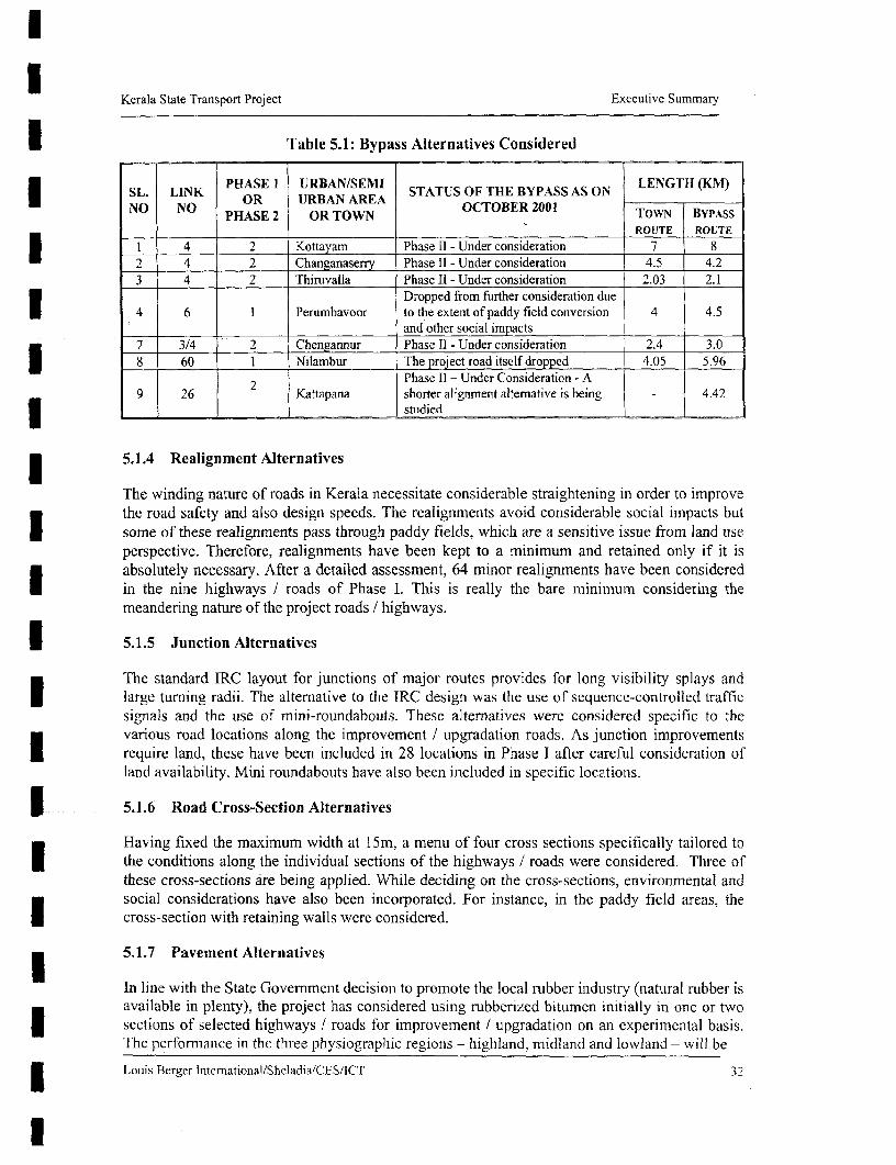
Kerala State Transport Project Executive Summary
Table 5.1: Bypass Alternatives Considered
SL. LINK PHASE I URBAN/SEMI STATUS OF THE BYPASS AS ON LENGTH (KM)NO NO OR URBAN AREA OCTOBER 2001
PHASE 2 OR TOWN TOWN BYPASSROUTE ROUTE
I 4 2 Kottayam Phase II - Under consideration 7 82 4 2 Changanaserry Phase II - Under consideration 4.5 4.23 4 2 Thiruvalla Phase II - Under consideration 2.03 2.1
Dropped from further consideration due* 4 6 1 Perumbavoor to the extent of paddy field conversion 4 4.5
and other social impacts7 3/4 2 Chengannur Phase II - Under consideration 2.4 3.0
J 8 60 1 Nilambur The project road itself dropped 4.05 5.96
2 Phase II - Under Consideration - A9 26 Kattapana shorter alignment alternative is being - 4.42
l _ _ studied
5.1.4 Realignment Alternatives
The winding nature of roads in Kerala necessitate considerable straightening in order to improvethe road safety and also design speeds. The realignments avoid considerable social impacts butI some of these realignments pass through paddy fields, which are a sensitive issue from land useperspective. Therefore, realignments have been kept to a minimum and retained only if it isabsolutely necessary. After a detailed assessment, 64 minor realignments have been consideredin the nine highways / roads of Phase I. This is really the bare minimum considering themeandering nature of the project roads / highways.
| 5.1.5 Junction Alternatives
The standard IRC layout for junctions of major routes provides for long visibility splays andlarge turning radii. The alternative to the IRC design was the use of sequence-controlled trafficsignals and the use of mini-roundabouts. These alternatives were considered specific to thevarious road locations along the improvement / upgradation roads. As junction improvementsI require land, these have been included in 28 locations in Phase I after careful consideration ofland availability. Mini roundabouts have also been included in specific locations.
| 5.1.6 Road Cross-Section Alternatives
Having fixed the maximum width at 15m, a menu of four cross sections specifically tailored tothe conditions along the individual sections of the highways / roads were considered. Three ofthese cross-sections are being applied. While deciding on the cross-sections, environmental andsocial considerations have also been incorporated. For instance, in the paddy field areas, thecross-section with retaining walls were considered.
5.1.7 Pavement Alternatives
In line with the State Government decision to promote the local rubber industry (natural rubber isavailable in plenty), the project has considered using rubberized bitumen initially in one or twosections of selected highways / roads for improvement I upgradation on an experimental basis.The performance in the three physiographic regions - highland, midlaind and lowland - will be
3 Louis Berger lnternational/Sheladia/CES/ICT 32

Kerala State Transport Project Executive Summary
studied. If the results are promising, the project will use rubberized bitumen widely. This willgive a tremendous boost to the rubber industry.
5.1.8 Maintenance Alternatives
For the Highways Maintenance Component, three treatment ahematives were considered. Thesealternatives do not have any environmental and social relevance.
5.2 PILOT WATERWAYS COMPONENT
5.2.1 "With" and "No Action" Alternative
Traffic on existing roads / highways has increased to saturation levels with high rates ofpollution, congestion and accidents. Studies show that the current imbalance in modal share canbe corrected to some extent, by rehabilitating the inland water transport system. The inlandwater transport system can share a large volume of traffic, particularly in the coastal belt. Inaddition, it can support the efforts to promote intemational tourism based on the rich backwaterresources of the State. The proposed Pilot Waterways Component is restricted to three canals toexperiment the feasibility of using the waterways (the State has more than 175 feeder / linkcanals with a total navigable length of 1160 km) an alternate mode of transport. The experiencegained will be used to develop a Master Plan for the revival of the entire waterways. The Stateintends developing the waterways through private sector investments. The "With" Alternative isdesigned to help in taking the process of using the waterways a step further. And, the "NoAction" alternative will only delay the further consideration using the State waterways as analternative mode of transport. The "With" alternative considers various design options to decidethe best cost-effective design that would have the least negative environmental and socialconsequences, and also maximises benefits.
5.2.2 Reason for choosing the waterways
Three waterways / canals were selected by the Irrigation Department under this project takinginto account how the canal network links to towns / industrial centers and the currentinfrastructure available (boat operations and jetty locations). This was selected because it wasfelt that these waterways will generate the maximum economic development of the region.Besides this prime criteria , the other parameters considered were the traffic potential, presenthardship faced by farmers and poor agricultural workers due to lack of adequate transport,expected impacts on poverty alleviation, inter-modal linking of terminals, continuity with theNational Waterway being currently developed from Kottapuram to Kollam and internationaltourism potential. After selecting these waterways, studies were carried out to ensure that theenvironmental and social consequences can be mitigated.
5.2.3 Design alternatives
The present width of the three waterways ranges from 15-20m. Three cross-section options wereconsidered: 15m wide & 1.8m depth, 17.50m wide & 2.2m depth, and 20m wide & 2.5m depth.These three options had varying requirements of land acquisition and quantity of dredge materialto be removed. The larger the cross-section, the greater will be the land requirement and thevolume of material to be dredged. The second option was selected because it was considered tobe of optimum width. Although the first option will have lesser environmental and socialconsequences, the waterways will fall short of the basic minimum requirements for encouraging
3 Louis Berger International/Sheladia/CES/ICT 33

Kerala State Transport Project Executive Summary
private sector investments.
6 ASSESSMENT OF POTENTIAL IMPACTS
6.1 HIGHWAYS COMPONENT: ENVIRONMENTAL IMPACTS
6.1.1 Impact on Climate and geology
No significant impacts to the climatic conditions or micro climatic conditions are anticipated.There will be no impacts on the geology as well.
6.1.2 Impact on Physiography
In all improvement / upgradation roads, there will an increase in the embankment height incertain sections. This will marginally impact the physiography of the areas.
6.1.3 Impact on Soils & Construction materials
There will be some soil erosion during the construction phase, particularly in the newembankments of the improvement / upgradation roads. Borrow material will be required for thesub-grade and borrow areas will have to be opened. While quarry dust and sand will be used forconstruction purposes, some amount of river sand will also be used in the improvement /upgradation roads. The removal of river sand will create an environmental impact. The stoneaggregates will be collected from the identified quarries and there will be some impacts duringquarrying.
6.1.4 Water resources & quality impacts
In terms of water availability, the project will not have any adverse impact. For instance, therequirement in Phase I for the upgradation / improvement is 10,000 litres per day per km, whichwill vary across different seasons. The quantity required will be easily met from the 75 (approx.)water bodies (rivers, lakes, streams and ponds) adjacent to the project roads / highways. Due tosoil erosion, these water bodies will be adversely affected if proper care is not taken. Other watersources such as public water supply system, public open well, bore well and water tanks will alsobe selectively affected as these are located within the construction area of the roads / highways.
There will be limited negative impact on the quality of water in the water bodies due to soilerosion during construction if adequate mitigation measures are not implemented. In theoperational phase, water quality may show slight improvements due to reduced erosion.
6.1.5 Drainage impacts
The drainage along the upgradation roads / highways will improve due to the new culverts /cross-drainage structures and side drains. There will be increased runoff due to widening of theroads / highways, but the impact will be negligible statistically. Along the maintenance roads,there will be better drainage due to the cleaning of culverts, other cross-drainage structures andside drains.
Louis Berger InternationallSheladia,'CES/ICT 34
l

l
Kerala State Transport Project Executive Summary
IX 6.1.6 Air Quality Potential Impacts
There will be some negative air quality impacts during the construction phase of the project thatis typical of road construction activities. However, the air quality during the operational phase ofthe project are expected to be positive due to the improved road / highway conditions.
6.1.7 Noise impacts
During the construction phase, the equipment operation may be the single most disturbing sourceof offensive noise. In the operational phase, the noise levels are expected to decreaseconsiderably due to reduced congestion. In spite of the general reduction in noise levels, some ofthe sensitive receptors will require some mitigation measures due to the close proximity to thehighways / roads. For instance, in Link 6 (Chainage 206) of the Phase I project, there is ahospital in Muvattupuzha, which will be adversely impacted.
6.1.8 Flora & Fauna Impacts
Roadside trees in the construction area of the upgradation / improvement roads will have to becut. These trees - either public or private ownership - have different girth sizes, which vary from3 1-4 m. Most of the trees are not planted but grow naturally. Table 6.1 provides the total trees tobe cut in each upgradation / improvement road / highway in Phase I.
| Table 6.1: Tree Removal along the Upgradation I Improvement Roads of Phase I
Link (kms) Public Private Trees TotalTrees__ _ _ _ _ _ _ _ _ _
l 1 (46.000) 116 119 235
2 (20.850) 144 25 169
3. (23.590) 37 7 446 (33.800) 56 1 !7
40 (32.980) 105 23 12850.1(45.300) 177 18 19570 (17.700) 59 1 1 7072 (12.580) 51 87 13873 (24.140 158 2 160
Total (256.940): 903 293 1196
Apart from roadside trees, there are no other direct impacts on flora. There will be no impacts onfauna as well.
There are no ecosensitive areas in the Phase I project upgradation / improvement roads andhence there will be no impacts. Some of the maintenance roads pass near or close to ecosensitiveareas and some induced impacts can be expected. Additional mitigation measures to addressthese to the extent possible have been specified in the ESMP. In Phase II, there are some roadsU that pass through ecosensitive areas. The nature of these impacts will have to be further studiedthrough detailed project-level EAs and appropriate EMPs developed.
Louis Berger International/Sheladia/CES/ICT 35

Kerala State Transport Project Executive Summary
6.1.9 Cultural Property Impacts
As there are several temples, churches, mosques and shrines along the project roads, these willbe partially impacted. In Phase 1, a total of 36 religious structures will be impacted. The nature ofimpacts will be very minor, e.g. the impact on the compound wall or a money collecting box /hundi along the ROW.
6.1.10 Paddy Fields Impacts
The conversion of paddy field for other land use application is an important concern in Kerala.During the construction phase, there is a potential for the use of paddy fields for borrow areas, ifproper mitigation measures are not followed.
6.2 HIGHWAYS: SOCIAL IMPACTS
6.2.1 Standard Avoidance
A joint decision among the engineering, environmental and social impact project preparationteams was taken to avoid land take from religious structures, such as, churches, mosques,temples, graves, sacred groves, etc., congested market areas (which would save bothdisplacement and livelihoods as well as excessive costs), and avoid splitting agricultural fields asfar as possible. A set of guidelines with social concern was prepared for the reference of thedesign engineers.
6.2.2 Corridor of Impact
The corridor of impact (COI) is the width required for the actual construction of the road,including the new pavements, footpaths, shoulders, support slopes, embankments, drainage, andnecessary safety zones. Within this corridor, there will be no structure or hindrance. The COI is,thus, the area that will be impacted by the proposed project.
The widening exercise has been strictly limited to the existing COI and where this has not beenpossible and compound walls and/or buildings have been affected, considerations were made onthe number of affected compound walls and/or buildings on either side of the road in a givenarea. The side having the less number of affected properties was chosen for the widening side asa measure of minimising impacts. This information is evident in the strip maps and the roaddesign maps.
Kerala being a land-scarce State and the roads here being typically narrow, to upgrade the projectroads to IRC (Indian Road Congress) recommended standards of 30m for four-laning wouldhave affected a very large number of people and properties. Even a compromise corridor widthof 23m would have affected a large number of people and properties. Although efforts havebeen made to confine the road improvements to the existing right of way, this has not alwaysbeen possible because of the topography and curves. The project has generally considered a 12-1 5m COI for a 7-metre carriageway.
Louis Berger International/Sheladia/CES/ICT 36
l

Kerala State Transport Project Executive Summary
6.2.3 Loss of Community Resources
Ribbon development along the roads is a part of the habitation pattern in Kerala; hence, the lossof most prevalent common property resources (CPR) i.e 117 are the roadside public wells, handpumps, water taps, large trees, and bus stops/shelters owned by the municipalities and thepanchayaths and public institutions like schools and hospitals, which will be replaced by theproject authorities or civic authorities. Several cultural properties i.e. 36 are also affected.
Every attempt has been made in the design to save the roadside hospital, school and othereducational institution buildings. If they are affected, it is only their compound wall and part ofthe compound that will be required for the project.
6.2.4 Minimising Resettlement
Several measures have been adopted for minimising resettlement in the KSTP. These includeapplying alternative alignments, and modifying the design according to the suggestions of theaffected persons to minimise their problems.
Table 6.2 indicates that after integrating the social concerns there has been a considerablereduction in the negative social impacts. The impact on the total population has been reduced byI approximately 50%. The number of project displaced persons has been reduced byapproximately 76%. The impact on the buildings has been considerably reduced byapproximately 64% and 71% for residential and commercial, respectively. Agricultural land isI not included in this comparison because the agricultural land was required and included as aresult of the final engineering design. Data obtained through the field surveys indicate that of the3287 residential and commercial affected structures, 1437 or 44% comprise structures whereI only the boundary wall or part of the compound have been affected. The existence of theboundary walls has actually saved a large number of affected families, total 2287, from being
2 ~~~displaced.displaced. Table 6.2: Minimising Negative Social Impact (Phase l)
Road No. of PAP No. of PDP No. of Affected Buildings* Links Residential Commercial **
Before* After# Before* After# Before* After# Before* After#Link 1 6571 3408 1146 383 601 254 1452 490Link 2 1354 587 156 76 432 140 277 87Link 3 1502 455 185 25 667 147 654 94Link 6 5865 3703 1116 67 817 319 1001 432Link 40 2105 1408 299 36 436 213 499 91I Link 50.1 3551 857 573 87 253 113 842 145Link 70 1955 1314 270 149 392 159 467 124Link 72 2300 1129 436 201 437 246 322 188Link 73 1291 626 144 14 452 17 317 28Total: 26494 13487 4325 1 03 8 4487 1608 5831 1679
* Before integrating social aspects # After integrating social aspects** Residential-cum-commercial structures are included in the commercial structure category
Louis Berger lnternational/Sheladia/CES/ICT 37
l

I Kerala State Transport Project Executive Summary
3 6.2.5 Overall Affected and Displaced People
Overall, the Phase I projects affects 13487 persons - of which 7454 are project affected families,* 859 are project displaced families, and 1038 are project displaced persons. Table 6.3 shows the
distribution of the project affected families and the extent of land take. The residential-cum-commercial mixed category has been included in the regular commercial category. Of the 7454PAFs, 6556 or 88% are titleholders. Of the non-titleholders, 823 are tenants, 46 squatters and 29encroachers.
| Table 63: Number of Affected Families and Land Take (Phase I)
Links Link Name Residential Commercial Agricultural Govt. Other Total* LaksLlk Nme PAF Ha PAF Ha PAF Ha Ha PAF Ha PAF Ha
I Kottarakkara 430 4.95 1490 1.62 187 8.06 0.51 102 1.08 2209 16.21
l 2 Kottarakkara- I .26 155 0.45 44 2.26 0.16 21 0.31 405 4.44Adur
3 Adur - 165 0.71 144 0.22 7 0.22 0.02 24 0.32 340 1.49
6 Muvattupuzha 596 0.85 968 0.61 14 0.35 0.04 45 0.20 1623 2.06- Angamalii
40 Thissura- 375 1.10 209 0.23 23 0.38 0.25 14 0.20 621 2.1740 Kuttipuram ______
50.1 Palakkad - 195 0.39 286 0.29 7 0.02 0.06 37 0.34 525 1.10
70 Muvattupuzha 330 1.53 277 0.64 151 4.43 0.15 8 0.77 766 7.52
72 |SiH-1-NH-47 367 2.45 347 0.57 128 3.68 0.01 25 0.39 867 7.09
|73 Cagaasery 32 0.04 56 0.04 4 0.02 0.0 l 6 0.04 98 0.15
| | Totals 2675 13.28 3932 4.67 565 19.42 1.21 282 3.65 7454 42.23
Percentages 36% 31% 53% 11% 8% 46% 3% 4% 9% 100% 100%
The "other" category includes families not identified with the well-defined categories ofresidential, commercial and agricultural and includes families owning fallow or unused land.This category also includes structures such as bus shelters, religious properties, schools andhospitals.
I Table 6.3 shows that of the three primary affected categories of residential, commercial andagricultural families, the commercial and residential-commercial mixed PAFs, 3,932 (53%) topthe list with 11% land area affected, followed by the residential PAFs, 2,675 (36%) with 31%
* land area affected and agricultural PAFs, 565 (8%) with 46% land area affected. Jobopportunities being generally severely limited in the State, most people often have chosen tradeand petty shops as their source of livelihoods. This is reflected in the project road survey: Theaffected families will be compensated according to the R&R policy of the project.
I Louis Berger Inter-niational,'Sheladia/CES/ICT 38
l

I Kerala State Transport Project Executive Summary
3 Displacement
The Phase I project displaces 859 families and the area thus affected is 6.88 ha. Table 6.4 showsthe different categories of displaced families and the area of land lost by them:
Table 6.4: Number of Displaced Families and Area of Displaced Families (Phase I)
l Links Residential Commercial Agricultural Total
PDF Ha PDF Hta PDF Ha PDF Ha
1 41 0.76 276 0.90 24 1.15 341 2.80
2 22 0.23 57 0.13 7 0.92 86 1.28
3 10 0.03 18 0.10 2 0.15 30 0.28
6 6 0.01 60 0.06 0 0.00 66 0.073 40 6 0.03 16 0.08 0 0.00 22 0.11
50.1 15 0.14 33 0.04 0 0.00 48 0.18
70 53 0.63 87 0.34 2 0.21 142 1.17
72 36 0.40 76 0.15 6 0.43 118 0.9773 0 0.00 6 0.01 0 0.00 6 0.01
Totals 189 2.23 629 1.81 41 2.86 859 6.88
Percentages 22% 32% 73% 26% 5% 42% 100% 100%
The 629 commercial PDFs, 382 are owners of commercial units and 227 are their employees.The remaining numbers constitute squatters. . Of the 859 PDFs, 254 are non-titleholders that
includes tenants.
I 6.2.6 Estimates of Land Required for the Project
The estimates of land required for the KSTP is a total of 99.30 hactatre. Out of which 42.23 hafor the Phase I roads, and 57.07 ha for Phase II.. The total land that will be acquired from privateowners for Phase I is estimated at 41.02 ha. A total of 565 families with agriculture land and5991 families owning structure will be affected by the project. Out of which 41 familiesdependent on agriculture will become landless and 563 families owning structures will bedisplaced.
1 6.2.7 Vulnerable Groups
The KSTP defines people as vulnerable if they are identified as earning up to 25% above theofficially recognised "below poverty line" (BPL). The BPL is determined by a survey conductedby the Rural Development Department of the respective State Governments, popularly known asthe IRDP (Integrated Rural Development Programme) Survey. The BPL in Kerala currentlystands at Rs. 19,000 per annum for a family of five members. Usually, the vulnerable groupsmay include but are not limited to the following categories of persons:
3 (a) Poor or landless people falling under the "below poverty line" category;(b) Members of the Scheduled Castes (SC) and Scheduled Tribes (ST);(c) Women headed households (WH);I (d) Orphans or destitute persons (socially handicapped); and(f) Disabled persons (physically or mentally handicapped).
3 Louis Bcrger International/Sheladia/CES/ICT 39
l

Kerala State Transport Project Executive Summary
lThe social surveys identified 2160 vulnerable families who will be affected and 174 will be
displaced.
6.2.8 Loss of Livelihood and Income Restoration
| It is estimated that the Phase I roads of the KSTP will effect loss of livelihood of 670 individuals.
Table 6.5 shows the link-wise number and categories of persons losing their livelihoods:
Table 6.5 Displaced Families Losing Livelihoods (Phase I)
Link Agriculture Commercial Units Squatters Vulnerable TotalOwner Employe Encroacher
* 1 24 179 85 1I 1 300
2 7 23 32 2 0 64
3 2 13 5 0 0 20
* 6 0 39 19 2 0 6040 0 12 4 0 0 16
50.1 0 19 13 1 0 33
70 2 45 40 2 0 89
72 6 47 29 0 0 82
73 0 5 0 1 0 6
Total 41 382 227 19 1 670
3 Income Restoration
In addition to entitlements for the loss of land, structures and other assets to the project affected
families as per the entitlement matrix of the KSTP R&R Policy, the RAP proposes to assist in
* income restoration and provide alternative economic rehabilitation assistance to displaced
residential families, wage employees, squatters, vulnerable encroachers, all other vulnerable
families, agricultural families, and commercial families. The following income restoration
i measures and categories of eligible families are adopted by the KSTP R&R Policy and the
further details are in Appendix A:
Economic rehabilitation grant
* All vulnerable families including BPL, women headed, SC, ST, disabled (#2160)
Transitional allowance (total 624 families)
Titleholder PDF, residential structures (#18 1)
Titleholder PDF, commercial structures including res-comm. mixed struc. (#382)
Titleholder displaced agricultural families (#41)Displaced squatters (#19)
Displaced vulnerable encroacher (#1)
Assistance for loss of wages
Displaced wage employees (#227)
Training for skill upgrading (total 287 families)
Displaced agricultural families (#41)
Displaced wage employees (#227)
Displaced squatters (#19)
Shifting allowance (total 582 families)3 Titleholder PDF, commercial structures including res-comm mixed struc. (#382)Titleholder PDF. residential structures (#18 1)
Louis Berger Intemational/Sheladia/CES/ICT 40
l

U Kerala State Transport Project Executive Summary
Displaced squatters (#19)Rental allowance (total 590 families)
Titleholder PDF, commercial structures including res-comm mixed struc. (#382)Titleholder PDF, residential structures (#18 1)Displaced residential tenants (#8)Displaced squatters (#19)
I The following table (Table 6.6) shows the number of eligible families link-wise for incomerestoration measures.
Table 6.6: Families Eligible for Income Restoration Measures (Phase 1)
Links 1 2 3 6 40 50.1 70 72 73Income Restoration Measures _ TotalEco. Rehab. Grant to vun. Fawn. 396 95 197 216 296 265 144 525 26 2160Transitional allowance 248 54 26 49 19 34 100 89 5 624Assistance for loss of wages 85 32 5 19 4 13 40 29 0 227Training for skill upgrading 112 43 7 23 4 1 5 46 35 2 287Shifting allowance 229 47 23 45 18 35 99 80 6 582Rental allowance 231 47 l 23 47 18 35 100 83 6 590
* An income restoration action plan has been appended (Appendix B).
6.2.9 HIV/AIDS
Highways are inadvertently associated with HIV/AIDS due to the behaviour of long distancetruckers and related reasons. The KSTP has addressed this issue in terms of awarenesscampaigns against this problem. An action plan has been prepared separately (Appendix C).
6.3 PILOT WATERWAYS COMPONENT: ENVIRONMENTAL & SOCIAL IMPACT
6.3.1 Impact on Physical Conditions
] The project requires approximately 156,000 cubic meters of sediments to be dredged over a totalof 42 km length in the three waterways. Associated with the dredging, there will be a temporarydisturbance to the aquatic environment. The dredged material has been tested and found to beI safe for disposal. However, the dredge material may be contaminated in certain sections,therefore it is proposed that tests will be done prior to disposal, and locations for disposal will befinalized in consultations with the people. Initial consultations in this regard have already beenI held, with positive feedback from the people. No adverse impacts are expected during theoperational phase.
U 6.3.2 Social Impacts
There would not be any project-affected people due to the Pilot Waterways component. For theconstruction of terminals at Kodimatha and Kottayam, there is sufficient government land andhence no land acquisition will be required. However, if there are any adverse impacts duringconstruction the R & R policy prepared for waterways will be applicable (Appendix D)
In the operational phase, the practice of disposal the sewage from the vessels / boats / terminal /jetties is likely to aggravate. Another impact is the loss of privacy especially for women whiletaking baths in the canal waters. The water hyacinth also increases the mosquito breeding in the
5 Louis Berger international/She]adiaJCES/ICT 41

Kerala State Transport Project Executive Summary
area. Public consultations revealed that all the inhabitants of the area wanted to eradicate themcompletely.
The Pilot Waterways component will have a positive impact as tourism will improve and thiswill increase the employment opportunities in the area. The availability of the waterways willalso enable the local population to enjoy better access to markets, schools, hospitals and othersocial amenities.
6.3.3 Impacts on Flora and Fauna
The removal of water hyacinth and the other aquatic weeds will be a major positive impact as itwill enhance navigation and health conditions of the area. There would not be any significantnegative impacts on the flora and fauna. The mangroves and the bird sanctuary are locatedapproximately five km away from the project waterways will not be affected.
7 ENVIRONMENTAL MANAGEMENT AND RESETTLEMENT ACTION PLANS
7.1 INTRODUCTION
The mitigation measures related to the environmental and social impacts of both the Highwaysand the Pilot Waterways Component have been developed. Further to the mitigation measures,enhancement measures have also been designed. Both the mitigation and enhancement measureshave been included in the various Environmental Management Plans (EMPs) and theResettlement Action Plan (RAP) that are prepared for the project. In Phase 1, for the HighwaysComponent, there is an EMP for each of the nine roads / highways that have been selected forthe upgradation / improvement. This EMP addresses the environmental mitigation andenhancement measures. There is a RAP for the upgradation / improvement roads / highways inPhase I. This RAP includes the plans related to land acquisition, compensation, resettlement andrehabilitation associated with the project. There is an Environmental and Social ManagementPlan (ESMP) for the maintenance activities of the Highway Component. This ESMP includesboth the environmental and social mitigation measures associated with the maintenanceactivities. For the Pilot Watervays Component, there is the EMP, which includes theenvironmental mitigation and enhancement measures, and the SIMP, which includes the socialmitigation measures required to be implemented.
The EMPs and RAP for the Phase II highways / roads is being prepared and is expected to becompleted in the next six months.
7.2 EMP - HIGHWAYS COMPONENT (PHASE - I: UPGRADATION / IMPROVEMENT ROADS)
EMPs for the nine upgradation / improvement roads in Phase I include a project description, anenvironmental strip plan, the institutional arrangements for implementing the mitigation /enhancement measures, Environmental Management Action Plan (EMAP), staffing / training /reporting requirements, environmental costs and an implemcntation schedule. This EMP includcsa Landscaping Tree Planting and Environmental Enhancement Plan. The design drawingspertaining to environmental enhancements have also been included in the EMP. Cross-referencesto the Contract documents and the Bill of Quantities wherever required are integrated. A typicalEMAP - Link I's EMAP has been included as a sample - has been attached as Appendix E.
Louiis Berer Iniemationa]/Sheladia!CES/ICT 42

Kerala State Transport Project Executive Summary
I The responsibility for implementing the nine EMPs will be with the PIU / PWD. There is anEnvironmental and Social Management Cell within the PWD, which will co-ordinate theimplementation of the EMP. This Cell is staffed with a Joint Director, an Environmental Officer
* and a Social Development Officer. At the field level, the existing PWD officials will be co-ordinating matters pertaining to environmental mitigation and enhancement measures. Tosupervise the implementation of the project, there will be Supervision Consultants, who willhave the required expertise to supervise the proper implementation of environmental mitigationand enhancement measures.
7.3 ESMP - HIGHWAYS COMPONENT (MAINTENANCE ROADS)
| ESMP for the maintenance programme includes the project description, background on themaintenance practices / components / references to the maintenance study, description of theenvironmental and social issues, Environmental & Social Management Action Plan (ESMAP)
| and the institutional mechanism / arrangements. The ESMAP includes reference to both genericmitigation measures relevant to the entire maintenance programme and specific mitigation
I rmeasures pertaining to the Year 1 maintenance programme.
The responsibility for implementing the ESMP will be with the PIU / PWD. The same ESMCwill co-ordinate the implementation of the ESMP. At the field level, the existing PWD officialsI will be co-ordinating matters pertaining to environmental mitigation measures. To supervise theimplementation of the project, there will be Supervision Consultants, who will have the requiredexpertise to supervise on the proper implementation of environmental mitigation measures.
J Further, Quality Assurance Consultants will also be involved in the supervision of themaintenance works.
7.4 EMP - PILOT WATERWAYS COMPONENT
EMP for the Pilot Waterways Components includes a project description, an environmental stripI plan, the institutional arrangements for implementing the mitigation / enhancement measures,Environmental Management Action Plan (EMAP), staffing / training I reporting requirements,environmental costs and an implementation schedule. The design drawings pertaining toI environmental enhancements have also been included in the EMP. Cross-references to theContract documents and the Bill of Quantities are integrated wherever required. This includes aseparate Dredge Disposal plan and a Water Hyacinth Management Plan. The EMAP is enclosedas Appendix F.
The responsibility for implementing this EMP will be with the PWD /PIU / IrrigationI Department - two engineers from the Irrigation Department are now a part of the PIU and willaid in the implementation of this component.The ESMC within the PIU will co-ordinate theimplementation of the EMP. At the field level, the Irrigation Department will be co-ordinatingI matters pertaining to environmental mitigation and enhancement measures. As in the case of theHighways Component, the Supervision Consultants will have the required expertise to supervisethe proper implementation of environmental mitigation and enhancement measures.
7.5 BUDGET FOR TIIE ENVIRONMENTAL COSTS
The total budget for implementing the environmental mitigation and enhancement measures forPhase I is Rs. 163.07 million for the Highways Component and Rs. 20.77 million for the Pilot
Louis Berger International/Sheladia/CES/ACT 43
l

Kerala State Transport Project Executive Summary
I Waterways Component. Table 7.1 provides the link wise cost. The environmental and social
mitigation measures have been combined for the maintenance programme.
The environmental budget for Phase II upgradation / improvement is estimated at Rs. 88.8
million.
7.6 RESETTLEMENT ACTION PLAN
7.6.1 Support Principles for Different Categories of Impacts
3 The Kerala State Transport Project's Resettlement & Rehabilitation Principles and PolicyFramework provides guidance for a developmental approach to resettle and rehabilitate the
3 ___________ Table 7.1: Environmental Budget
.TMonitoring EnvironmentProject Total Total Institutional al tnitigation EnvironmentalU component Project cost Environmental And training and cost as % of total
(INR m) cost (INR m) costs (INR m) enhancement cost.cost (IN m) costs (INR m)
Link 1 895.14 22.41 10 12.41 1.49
Link 3 665.97 32.19 20 12.19 4.83
Link 6 560.58 18.159 10 8.159 3.24
Link 40 576.97 19.805 1O0 9.805 3.43Link 73 273.64 14.124 10 4.124 5.16Link 72 335.21 =1 4.616 10 4.616 4.36Link 70 352.12 17.872 10 7.872 5.07Link50.1 643.11 2.894 10 13.894 2.16
IWT 367.15 20.274 5.5 14.774 5.52component ._ _
First YearMaintenance 935.894 9,36 0 9.36 1.00component
Totals 5605.784 192.704 95.5 97.204 36.26
people affected by the project. In particular the policy document highlights that:
* Wherever possible, displacement will be reduced or avoided altogether by sensitive design of
civil works (viz., alternative designs or modifications to the design).
| * Where displacement is unavoidable, those displaced will have their living standards
improved.
* As far as possible, the displaced persons from one location will be located as a single unit.
| Particular attention will be paid to the needs of the most vulnerable groups to be resettled.
* The PAPs will be compensated at replacement cost for assets lost, irrespective of their legal
standing in the project area. Special assistance will be extended to the vulnerable to enhanceI their earning opportunities.
* The PAPs and the host communities will be encouraged to participate in the design and the3 implementation of the RAP.
Table 7.2 summarises the various supports that the KSTP R&R Principles and Policy documenthas identified for the resettlement and rehabilitation of the project affected families and details
are in Appendix F:
Louis Berger International/Sheladia/CES/IICT 44
l

U Kerala State Transport Project Executive Summary
3 Table 7.2: Broad Entitlement Framework
KERALA STATE TRANSPORT PROJECTResettlement and Rehabilitation: Broad Entitlement Frame Work
Land Inside Right ofImpacts and assistance criteria acquisition Way
vulDeable Non Vunrbe Nonl Vulnerable |Vulnerable rable Vulnerable
A. Corridor of Impact: Loss of land and other assets Support given to families and householdsI Consultation, counseling regarding altematives,I and assistance in identifying new sites and Yes Yes Yes Yes
opportunities
2 Compensation for land at replacement cost, Yes Yesplus allowances for fees or other charges
3 Advance notice to harvest non-perennial crops, Yes Yes Yes Yesor compensation for lost standing crops
Compensation for perennial crops and trees,4 calculated as annual produce value for one Yes Yes
-season
S Compensation or R&R assistance for structures Yes Yes Yes Yesor other non-land assets3 6 Shifting assistance Yes Yes Yes YesOption of moving to resettlement sites (in a
7 group of minirmum 25 families) incorporating Yes Yes Yes Yesneeds for civic amenities
B. Corridor of Impact: Lost or diminished livelihood Support given to adult individuals
8 Rehabilitation and assistance for lost or Yes Yes Yes Yes *diminished livelihoodI Additional support mechanisms for vulnerable
9 groups in re-establishing or enhancing Yes Yes Yeslivelihood
10 Employment opportunities in connection with Yes Yes Yes YesI project to the extent possible Y Y
Any other impacts notIJetidentified, r Unforeseen impacts shall be documented and11 Any other smpacts not yet identfied whether mitigated based on the principles agreed upon in
X ~~~~~loss of assets or livelihood thi o.i frmwr_ ~~~~~~~~~~~~~~~~~~this policy framneworkC. Indirect, group oriented impacts in the vicinity of the road corridorGroup oriented support will be given to mitigate negative impacts on the community, and to enhanceU development opportunities. Addressing traffic safety needs of pedestrians will target particular support atmore vulnerable groups, for example.
7.6.2 Targeted Support for the Vulnerable Groups
All vulnerable families will receive economic rehabilitation grant. The non-titleholder displacedvulnerable families will receive, in addition to the normal assistance as per the R&R Principlesand Policy document, a plot of land each free of cost at 40 m2 per family.
3 Louis Berger International/Sheladia'CES/ICT 45
l

Kerala State Transport Project Executive Summary
7.6.3 Implementation Requirements
Cut-off Date
As the census survey for the KSTP continued for over a year during 2000-2001, the cut-off dateI for the purpose of assistance to the eligible squatters and encroachers is the start date of thecensus surveys in a given link. The following table (Table 7.3) lists the links and dates when thecensus surveys were initiated.
Table 7.3: Project Road Links and Dates of Census Surveys
Si. No. Links Link Name Date of CensusI 1 Taikkod - Kottarakara 10 April. 20002 2 Kottarakara - Adur 27 Apfil, 20003 3 Adur- Chengannur I May, 20004 6 Muvattupuzha - Angamali 18 February, 20005 40 Thrissur - Kuttipuram 6 October, 20006 50.1 Palakkad - Shornur 31 January, 2001i 7 70 Muvattupuzha - Thodupuzha 5 February, 20008 72 SH-1 - NH-47 Link 29 November, 20009 73 Changanassea - Alappuzha 16 June, 2000
3 The Land Acquisition Process
The land acquisition process is the first high profile activity for the implementation of a projectlike this, and often the most difficult one. For some people the Government's land acquisitionprocess is difficult because people develop emotional attachment to their properties.
The Land Acquisition Act [1894/1984] (LA Act) facilitates the acquisition of the privatelyI ovwned lands by the Government in India. The objective of the LA Act is to empower theGovernment to acquire lands only for public purpose or for a company. If lands are needed for apublic purpose they cannot be acquired by an executive action without following the provisionsI of the LA Act. The provisions of the Act will apply only to the private lands. There are separaterules for alienation or transfer of Government land in favour of any other Government3 department for public purposes.
It is expected that due to greater interaction of the PWD with the project affected persons,dissemination of information, and the policy of offering replacement value of land and other
| assets (in the determination of which the PAPs will be partners), the possibility of litigationwould be avoided. The Table no 7.4 shows the action plan for land acquisition of Phase 1.
Coordination between Civil Works and Resettlement
Effort has been made to reduce potential negative impacts of the project. The KSTP hascoordinated the design process with the findings from screening and studies related to socio-economic impacts and the environment in order to minimise negative impacts and maximisebenefits. The practice will continue throughout the project implementation period.
During project implementation, the resettlement programme will be coordinated with the timingof civil works. The project will provide adequate notification, counselling and assistance to theaffected families so that they Are able to move or give up their assets without undue hardship
| before civil works are to start.
Louis Berger Intemational/Sheladia/CES/ICT 46
l

Kerala State Transport Project Executive Summary
Implementation Schedule
3 The implementation of the RAP will consist of land acquisition and R & R activities. The PIUwill further detail the implementation schedule, with possible support from the ProjectCoordinating Consultants (PCC) during the implementation, of the project. The programme3 schedule for the remaining major tasks of the RAP is shown in Appendix G. This schedule will
Table 7.4: Action Plan for Land Acquisition in the Kerala State Transport Project* (Phase I Roads)
Land Target Dates for Acquisition under LA Act 1894Link Length Acquisition Requisition Issue of Issue of Issue ofNo. Link Name (km) Requirement to Section 4(1) Section 6 Section 9 Declaration
_ (Hua) Compethrnt Notification Notification Notification of Award
1 Taikkod-Kottarakara 46.000 16.21 31.10.01 15.12.01 28.2.02 15.3.02 31.5.02
2 Kottarakara-Adur 20.850 4.44 31.10.01 15.12.01 28.2.02 15.3.02 31.5.02
3 Adur-Chengannur 23.590 1.49 31.10.01 15.12.01 28.2.02 15.3.02 31.5.02
6 Muvattupuzha-Angamali 33.800 2.06 31.10.01 15.12.01 28.2.02 15.3.02 31.5.02I 40 Thrissur-Kuttipuram 32.980 2.17 31.10.01 15.12.01 28.2.02 15.3.02 31.5.02
50.1 Palakkad-Shornur 45.300 1.10 31.10.01 15.12.01 28.2.02 15.3.02 31.5.02
70 Muvattupuzha- 17.700 7.52 31.10.01 15.12.01 28.2.02 15.3.02 31.5.02Thodupuzha___
72 Taikkod-Kazhakuttam 12.580 7.09 31.10.01 15.12.01 28.2.02 15.3.02 31.5.02
73 Alappuzha- 24.140 0.15 25.8.2001 15.12.2001 28.2.2002 15.3.2002 31.5.2002Changanassery
Total 256.940 42.23
be updated as the project progresses. The road link level R&R Project Managers will prepare asimplified summary on the operational aspect of the implementation plan. It is expected that theR&R activities of the project will be completed in approximately 36 months time, with someactivities stretching out longer, provided that no environmental clearance is required for landacquisition.
Fund Flow
Assistance: A joint account will be opened at a local Bank. The signatories will be the entitledperson, road link level R&R Project Manager (NGO contractor) as Verifying Officer and anNGO representative. Cheques will be given for all assistance. Apart from shifting and rentalallowance the others will be deposited in the joint accounts. The amount will be withdrawnagainst the purchase of productive assets. In case of structures the withdrawal will be in threeinstalments against the progress of construction, i.e., (a) foundation, (b) walls, and (c) roofcompletion.
Compensation: According to the current law the owner will receive cheques from the districtadministration for the entitled compensation. All payments of cheques will be made in theI village office in the presence of the district administration representative, the road link level
Louis Berger International/Sheladia/CESllCT 47

Kerala State Transport Project Executive Summary
Project manager and the NGO representatives.
7.6.4 Implementation Arrangements
The PIU of the PWD will implement the R & R component of the Kerala State Transport Project.The responsibilities include planning, implementation and monitoring of land acquisition andR&R related programmes. Since land on the existing corridor belongs to the State, theGovernment, on behalf of the PWD will acquire land. The State district administration willacquire private land on behalf of the PWD.
Central Level Arrangement
The Project Director at the PWD is responsible for overall performance of the R&R Cell and theRehabilitation Officer as the programme coordinator will be responsible for overall projectcoordination and management. The R&R Cell will have a small team of support staff dedicatedI to the social aspects component of the PWD, including a land acquisition officer. Presently allrequired personnel in the Environmental and Social Management Cell (ESMC) of the PWID arein place.
The ESC of the PWD will be responsible for the establishment and maintenance of a centralisedRAP management system. In the development of this system, particular attention will be paid to:
(a) Procedures for undertaking and completing census and asset verification exercises;(b) Updating of RAP data bases for each road link as well for the project as a whole;(c) Integration of land acquisition, compensation and construction activities;(d) Establishment of procedures for internal monitoring and review of road link level
progress reports; and(e) Procedures for the prompt implementation of corrective actions and the resolution of
grievances.
District Level Arrangement
In the project affected district, the Executive Engineer of the Division will function as theRehabilitation Officer of the District Level Committee (district level R&R Cell). It is
* recommended, if necessary, to bring in capable officials from other Government Departments aswell and obtain their services through deputation to undertake this work. These officers,3 especially the Executive Engineer as Rehabilitation Officer, will work closely with the NGOsengaged at the road link level.
The R&R Policy Framework has recommended the assistance of the District Revenue Officerand any other representative from the district administration and representatives of thePAPs/PDPs in the District Level Committee (DLC). The DLC is responsible for assessing thereplacement value of the project affected properties and for monitoring and evaluation at the roadlink level.
Project Level Arrangement
While the PWD central level and district level arrangements are necessary for the coordination ofthe RAP activities, the project level or road link level arrangements are most important foreffective RAP implementation. The work of identifying and developing the resettlement sites forindividuals or groups and other R&R related development activities will be undertaken by the
LoLuis Berger International/Sheladia/CES/ICT 48

Kerala State Transport Project Executive Summary
I road link level contractor (NGO) appointed by the PIU.
The NGO contractor will appoint a Project Manager, supported by one Overseer and four FieldAssistants, for each road link. This number, however, will vary according to the length of agiven road link. Each of these road link R&R teams will be advised by the DLC discussedabove. The overall functions of the project level R&R team are:
(a) To establish and maintain consultation mechanisms with the supervisingRehabilitation Officer;
(b) To integrate land acquisition, compensation and construction activities;(c) To establish proper PAP databases for the road link under its control;(d) To establish and maintain effective consultation mechanisms with the affectedI households and communities;(e) To regularly liaise with the DLC regarding the list of entitled persons, eviction
notices, compensation payments and grievance redress;I (0) To regularly liaise with the District Revenue Officer to ensure prompt transfer ofaffected land titles to the Revenue Department; and
(g) To ensure implementation of resettlement and rehabilitation and support measures asdetailed in the entitlement policy.
Coordination with Line Agencies
Various Govemment agencies, especially the Revenue and Health Departments will have animportant role in the smooth functioning of the resettlement programme. The PWD will beresponsible for the over-all coordination of this work.
7.6.5 R&R Costs and Budget
7.6.6 The Highways
The estimated budget for R&R, including land acquisition for both Phases I and II is INR1,430.0 million. The Bank component in the R&R of the project is estimated to cost INR 660.0million (approximately INR 330.0 million for each phase). More specifically, the estimated costof R&R for the Phase I roads is INR 694.60 million, of which the PWD component is INR 381.0I million and the Bank component is INR 313.60. The following tables (Table 7.5 and 7.6) showthe component-wise outline budget for the Phase I and Phase II roads in million Indian Rupees(Details in Appendix H), Phase II extrapolated from Phase I data.
Table 7.5: Costs and Budget of the KSTP R&R in Million INR (Phase I)
Items Packagel Package 3 Package 4 Total_________ _PWD WB PWD WB PWD WB PWD WB
* Compensation 248.7S 0 89.63 0 36.73 0 375.14 0Assistance 3156 189.61 1-37 68.14 0.43 44.24 5.36 301.99Support 0 4.93 0 2.78 0 1.78 0 9.49OtherActivities 0.25 0.99 0.15 0.69 0.10 0.44 0.50 2.12Total 252.59 195.53 91.15 71.61 37.26 46.46 381.0 313.6
3 Louis Berger International/SheladiaICESIICT 49
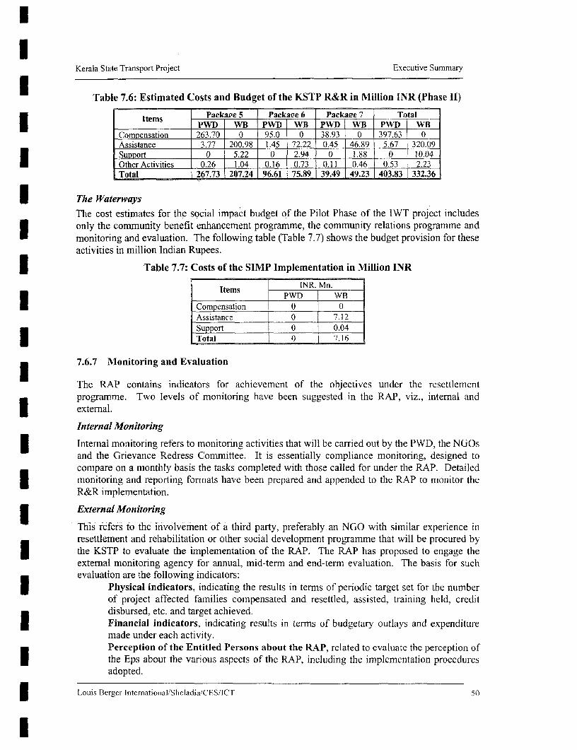
Kerala State Transport Project Executive Summary
I Table 7.6: Estimated Costs and Budget of the KSTP R&R in Million INR (Phase 11)
*tems - Package 5 Packape 6 Packaipe 7 TotalItems PWD WB PWD WB PWD WB PWD WB
Comoensation 263.70 0 95.0 0 38.93 0 397.63 0Assistance 3.77 200.98 1.45 72.22 0.45 46.89 5.67 320.09Suwport 0 5.22 0 2.94 0 1.88 0 10.04Other Activities 0.26 1.04 0.16 0.73 0.11 0.46 0.53 2.23Total 267.73 207.24 96.61 75.89 39.49 49.23 403.83 332.36
I The WaterwaysThe cost estimates for the social impact budget of the Pilot Phase of the IWT project includes3 only the community benefit enhancement programme, the community relations programme andmonitoring and evaluation. The following table (Table 7.7) shows the budget provision for theseactivities in million Indian Rupees.3 Table 7.7: Costs of the SIMP Implementation in Million INR
q Items ~~~ ~~~~~~~~~~~pWD WB
Compensation 0 0Assistance | 0 7.1]2Support 00.04
i ~~~~~~ ~ ~ ~~~~Total 0 7.16
7.6.7 Mlonitoring and Evaluation
The RAP contains indicators for achievement of the objectives under the rescttlemcnt
prograrnme. Two levels of monitoring have been suggested in the RAP, viz., internal and
3 ~~external.
Internal Monitoring
| ~~Internal monitoring refers to monitoring activities that will be carried out by the PWD, the NGOs
and the Grievance Redress Committee. It is essentially compliance monitofing, designed to
compare on a monthly basis the tasks completed with those called for under the RAP. Detailed
| ~~monitor-ing and reporting formats have been prepared and appended to the RAP to monitor the
R&R implementation.
| ~~External Monitoring
This refers to the involvement of a third party, preferably an NGO with similar expenience in
a ~~resettlement and rehabilitation or other social development programme that will be procured by
| ~~the KSTP to evaluate the implementation of the RAP. The RAP has proposed to engage the
external monitoring agency for annual, mid-term and end-term evaluation. The basis for such
| ~~~evaluation are the following indicators:
| ~~~~Physical indicators, indicating the results in termns of periodic target set for the number
of project affected families compensated and resettled, assisted, training held, credit
s ~~~~~disbursed, etc. and target achieved.
| ~~~~Financial indicators, indicating results in terrns of budgetary outlavs and expenditure
made under each activity.v ~~~~Perception of the Entitled Persons about the RAP, related to evaluate the perception of
X ~~~~the Eps about the various aspects of the RAP, including the implementation procedures
adopted.
f ~~~LoLuis Berger lnternational/Sh1eladia/CSIlCT 50

Kerala State Transport Project Executive Summary
Estimation of Quality of Life, refers to the combination of objective conditions, whichwill be measured numerically and subjective perception about those objective conditions.
7.7 TRAINING AND AWARENESS PLAN
PWD officers at the district level who will be associated with the environmental and socialactivities have been identified. A one-day in-house training programme was conducted on 24August 2001 for the officials from the southern districts of the State to sensitise them on thesocial and environmental issues in a transport project involving land acquisition anddisplacement of people. Two more similar training sessions of two days duration each have beenplanned to be conducted October and November 2001, comprising the PWD officials in thecentral and northern districts. The training exercise will be periodically organised. It has beenplanned to commission specialised training institutes to prepare tailor made training modules forthe training of the PWD officials.
Some of the training institutes identified at this stage are (1) Loyola College of Social Sciences,based in Trivandrum; (2) KIRTADS, based in Kozhikode, and (3) Administrative Staff Collegeof India, based in Hyderabad.
The process of identifying NGOs to be associated with the project started in April 2001. Theengagement of NGOs is expected to be completed in April 2002 and they would be giventraining along with the identified PWD officials on R&R and environmental issues. It is plannedto impart training at a time to a group of 15 persons. The training contents will be repeated toinclude the identified personnel of the Supervision Consultants when they are in place.
Table 7.8 outlines the training programme on R&R and Environmental issues organised by theEnvironmental and Social Cell of the PIU:
Il
3 Louis Berger International/Shcladia/CES/ICT 51
l

Kerala State Transport Project Executive Summary
| Table 7.8: KSTP Training Programme on R&R and Environment
# Who Attends? Training Programme on Instruction DurationPWD's PIU RO, Regulation and Policies Related to LandDivision Executive Acquisition/R&R and Environment: landEngineer, NGO, acquisition; KSTP R&R policy; basic features ofSupervision the RAP; institutional arrangement; monitoring, Lecture l/ dayConsultant evaluation and reporting; planning for relocation;
documentation requirement of the project;environmental overview; environmentalregulations and Acts.
PWD's PIU PD and Salient Features of the KSTP R&R Policy andRO, Chief Engineer, general EA ! aspects: implementationSuptdt. Engineers, arrangements, roles and responsibilities,
2 Division Executive grievance redress cell and district level WEngineer, NGO, committees, continued consultation and feedback, Workshop /2 daySupervision labour laws, gender issues, health and hygiene
l ~~~~~~Consultant issues, environmental awareness and safeguardsin the project.
# Who Attends? Training Programme on Instruction Durationi| ~~~~PWD's PIU PD and Effective R&R and EMP Implementation:
I RO, Chief Engineer, experience sharing related to R&R and EMPSuptdt. Engineers, implementation, disbursement mechanism, Lecture and
3 Division Executive conflict resolution methods, contingency Group '/2 dayEngineer, NGO, management, rapid appraisals, documentation, DiscussionSupervision monitoring and reporting, pollution andConsultant environmental impact assessment.PWD's PIU PD and Long Term Environmental and Social Issues inRO, Chief Engineer, the Highway Sector: social and environmentalSuptdt. Engineers, assessment methods, analytical tools, monitoring dDivision Executive and evaluation, social risk assessment and Group '/2 dayEngineer, NGO, management, concept of R&R resource centres, DiscussionSupervision integration of social and environrmental issues andConsultant good practices, long term environmental issues ina highway management.
| ~~~~Loutis Berger Intcrnational/Shcladia/CESllCT 52

APPENDIX A
PUBLIC WORKS DEPARTMENT
GOVERNMENT OF KERALA
INDIA
KERALA STATE HIGHWAYS PROJECT
REHABILITATION & RESETTLEMENT:
PRINCIPLES AND POLICY FRAMEWORK
August 2000

Table of Contents
I. NTRODU;CTION . ... ........ . .. . __.._............. .. ........ . .... . ..... _. ..... _1
2. BROAD PRIN'CIPLES ........... . . _1
3. ABBREVIATIONS A4ND TERNIS .._ ........ _. ................... 2
4. DEFINITIONS ............... - -_ - ._.4
5. BROAD PROCEDURES ................... . . . . . .._ .5
6. SOCIAL IMPACT ASSESSfMENT A]ND RESETILEMENT PLANNING .......7
7. IMPLEMEN-TATION': ACQU-ISITION OF LAND AND PROPERTIES ..... 8......... ..... 8
8. RESETTLEMENT AND REHABILITATION .......................................... . _ . 9
9. NONITORING AND POST - PROJECT EVALUATION ........ ............. .......... __0
10. ORGANIZATIONAL STRUCTURE . .... ... ............ . ... _._._._._.10
11. COST AND BUDGETING .. ................ _ _ -11
12. GRIEVANCE REDRESSAL CELL ........................... _ 11
13. SCOPE FOR MAIKNG AMIENDMIENTS IN THE R&R POLICY ........... . . 11
Annt=re . ............ _._. ................ _ ._ .. . ... . ...... _12
Annerureff.. .. . ........ ................. .___ . .... _._ .. ..... ..... _. ...... -13

l
KERALA S1 ATE HIGHWAYS PROJECT
REHABILITATION & RESETTLEMENT:
| PRINCIPLES AND POLICY FRAMNEEWORK
1 IINTRODUCTION
The Government of Kerala is preparing the state highways project. The aim of the project is toimprove and strengthen the state's transport networlc
Apart from the positive aspects of the road upgadation, the project may cause people to loseproductive land or house plots. structures, wells, trees or other assets or to lose income otherwise.The policy recognizes those people who are likely to he affected by the upgradation and widening ofthe road network and support mechanisms are proposed to be provided accordingly.
I 1This document describes the principles and approaches to be followed in minimizine and mitigatinonegative social and economic impacts caused by the project. It proVides the basis for a detailed andtime-bound Resettlement Action Plan (RAP), which vill be prepared for the project. The RAP willcontain the details of census. baseline socio-economic surveys of the potentially affected populationundertaken during the preparation of the project, rnitigation measures. implementation arrangementand plans. budget, monitoring and evaluation parameters.
2 BROAD PRINCI1PLES
2.1 These guidelines are prepared to address the issues related to the Kerala SLate HighvwaysProject for resettlement & rehabilitation (R&R) of the project affected persons (PAP). The guidelines
* outline the range of assistance in re-establishing their homes and livelihoods in the course of theimplementation of the project. The avoidance of involuntary resettlement is an integral part of theproject design but will be dealt with from the earliest stages of the project preparation. The broadprinciples of the R&R policy are as below:
a) The negative impact on persons affected by the project should be avoided or minimized.exploring all viable alternative project designs.
b) Where the negative impacts are unavoidable, the project-affected persons shouid be assisted inimproving or regaining their standard of living.
c) People's participation should be undertaken in the planning and implementation of the project.
d) Positive impacts will be enhanced as far as possible.
2.2 The project will broadly have three impacts that require mitigation measures. They are:
a) Loss of assets, including jand and house;
b) Loss of livelihood or income opportunities;I c) Collective impacts on groups, such as loss of common property resources.
The first t v'o categoties represent direct project impacts on an identified population. The people likelyto be affected by the project -ill be surveyed and registered. and project monitoring and evaluationwill compare longer-term impacts against baseline socio-economic data.
l

2
The third category represents a group impact where group members need not be individuallysurveyed. Gains and losses of a group-oriented nature are not quantifiable in terms of impact on theindividual. Mitigation and support mechanisms will be collectively oriented, and the monitoring will Ifocus on impact on such groups.
2.3 All acquisition of private land would be under the Land Acquisition (Amendment) Act. 1984,which provides for compensation for the properties to be acquired. Further support will be extendedunder the broad principles of the policy to meet the replacement value of the assets and improve theirstandard of living. 32.4 The common property resources will be replaced as far as feasible and assistance will beprovided at replacement value to the group.
2.5 Major widening and strengthening work planned will take place within the ROW based onland availability, gradienLt traffic and congestion'of population along the road length. However, majorland acquisition and many impacts are perhaps not foreseen except at locations where existing Ialignment may involve shifting to accommodate bypasses. geo-metrics and other cost effectiveimprovements. Efforts will be made during implementation to minimize any disturbance in the dailyactivities of the local populace.
2. 6 Before taking possession of the acquired lands and properties. all compensation, resettlementand rehabilitation and related activities would be made in accordance with this policy.
2.7 All land acquisition will be after harvest of crop.
2.8 If resettlement sites are developed as part of the project. the local "host population" should aalso be consulted about their views and needs. There should be no or minimum adverse social,economic and environmental impacts of displacement on the host population and specific measuresshould be provided in the RAP to mitigate any such impacts.
2.9 The broad entitlement framework of different categories of project-affected people shall be asper Annex I. The suggested format for detailed entitlement matrix shall be as per Annex II. Theassistance specified in the entitlement matrix will be adjusted to reflect the annual inflation rate.
2.10 During project imnplementation, the resettlement program will be coordinated with thecompletion of desimns and the likely timing of civil works. The project will provide adequatenotification, counselling and assistance to affected people so that they are able to move or give uptheir assets without undue hardship before commencement of civil works. I2.11 The project will ensure that civil works are not started on any road segment beforecompensation and assistance to the affected population has been provided in accordance with thispolicy framework.
3 ABBREVLTIONS AND TERNIS
Following abbreviations and terms will be found used both in the policy and the RAP:
a) Abbreviations:
B.P.L Below Poverty Line
B.S.R. Basic Schedule of Rates
C.G.I. Corrugated Galvanised Iron
C.O. I Corridor of Impact

3
C.P.R. Common Propert Resources
EP Entitled Person
Ha Hectare
M.E.H. Minimum Economic Holding
N.G.O. Non-Govermnental Organization
P.A.P. Project Affected Persons
P.D.P. Project Displaced Persons
R.A.P. Rehabilitation Action Plan
R.O. Rehabilitation Officer
RO.W. Riaht of Wav
R&R Resettlement and Rehabilitation
S.E.S Socio-Economnic Survey
*SC Scheduled Caste
S.T Scheduled Tribe
u/s Under Section
b) Terns
Adhararn Basic record of land rights. (North Indian. Perso-Arabic derived term isJamabanidi.)
Cent A local land area measurement term, one-hundredth of an acre. equivalent to40 sq. mt.
Corridor of Impact Width of corridor required for the construction of road and for its safety zone.
Danam Land Include lands attached with Temples (pandaramvaka), Mosques (vakj,Churches (edavaka) etc. where priests are allowed to cultivate the samewithout having to pay revenue to the State for the same. (North Indian,Perso-Arabic derived term is Muafi Land.)
Development Block A number of villages grouped together form a Development Block.
District Collector Administrative head of a District.
Hectare (Ha) A unit measuring land area. One Hectare equals 10.000 Sq. meters or 2.475Acre.
Kole Land Low land for agriculture, especially found in the Kuttanad area.
Lessee A person wvho, not being a tenant, is allowed to cultivate land on certain terms' and conditions.
Panchayat Elected local self-governing body at village level.


I 4
| Panchayat Samiti Local Self-governing body at Block level is Panchayat Samiti.
Pattayam Land deed.
Puramboke Land Revenue land adjoining streams. rivulets, tanks, canals and roads.
I President Elected head of a Grama Panchayat.
4 DEFINITIONS
4.1 Cut-off date
3 Cut-off date shall be the following:
a) In the case of land acquisition affecting legal title holders, the cut-off date would be the date ofissuing the notice u/s 4(1) of LA. Act.
b) For the non title holders the cut off date will be the date of census survey
4.2 Project Displaced Person
A project displaced person (PDP) is one who is compelled to change his/her place of residence and/orworkplace or place of business due to the project.
4.3 Project Affected Person
Unless otherwise specified in this Policv document, a project affected person is one who, inconsequence of the project. sustains damages (a) by reasons of severing such land or (b) by affectinghis/her immovable properties in any manner or (c) by adversely affecting his/her livelihood/earningscalculated by an objective assessment. The category of project affected person (PAP) includes projectdisplaced person (PDP).
4.4 Defuiition of Family
a) A "Family" shall mean Husband/Wife and minor children.
b) Every son or unmarried daughter who has attained the age of 18 years on or before the cut-off-date will be treated as separate family.
c) Every divorced or widowed daughter living separately or with the family on or prior to cut offdate will be treated as separate family.
4.5 Landless/Agnrcultural Labourer
A person who does not hold any agricultural land and *vho has been deriving his main income byworking on the lands of others as an agricultural labourer prior to cut off date.
4.6 Encroacher
A person is an encroacher if he/she has trespassed Government land, adjacent to his/her own land orasset to which he/she is not entitled, and who derives his/her livelihood and housing therefrom prior tothe cut-off date.
4.7 Squatter
A squatter(is a person who has settled on publicly ownmed land for housing or livelihood withou'tpermission or who has been occupying publicly owned building w%ithout authority prior to the cut-offdate.
I

5
l4.8 Income
Income of a PAP shall mean the amount of income as shoun in his Income Tax Return prior to thecut-off date. In the absence of such a retun. his income shall be calculated bv an objective assessmentapplying the same method as adopted by the Government agencies for identfing B.P.L. families.
4.9 Below Pover line
A household whose monthly consumption expenditure is less than a designated sum as determined bvthe Department of Rural Development Govermnent of Kerala, * ill be considered below povertv line.
4.10 Vulnerable Person
Unless othervise specificallv mentioned in this document, a person who has been designated asfalling under the 'Below Povert- Line' categerv and earning up to 25% above the poverty level will beconsidered a vulnerable person Generallt, the vulnerable groups mav include but not be lirited to Ithe:
a) Poor or landless people falling under the "Below Povertv Line" categorv:
b) Members of the Scheduled Castes and Scheduled Tribes:
c) Women-headed households:
d) Orphans and destiture persons (socially handicapped): and
e) Disabled persons (physicaHly handicapped).
4 11 Targeted Supporr Io Vulnerable Groups
The project will determine. through censu's surveys and other studies, who among the affectedpopulation mav be considered as vuLnerable or at risk. The vulnerable groups will receive targetedsupport and special attention from the project, and provided support mechanisms.
!5 BROAD PROCEDLRES
5.1 Basic Approach
a) The project recognizes that along with the positive aspects of infiastructure development, thereare also negative impacts. wvhich include the possible loss of assets, the loss of house and shelter.and the loss of liv-elihood or income opportunities. Moreover, a project like this inflicts someimpacts on the community as a whole. such as. loss of access to community facilities lice schoolsand hospitals. access to wxater and sanitation, and access to comnnon proper resources.
b) People losing their home represent a particular challenge in the resettlement programn. Every effortwill be made by the projecr to ensure that new housing is available before people are required torelocate.
c) Every effort should be made during project design and preparation to minimize acquisition of landand other assets and to reduce negative socio-economic impacts. The structures/assets filllingoutside the Corridor of Impact would as far as possible be left undisturbed.
d) If the project impact leads to people being unable to continue w-ith their previous occupation, the |project wNill provide supporT and assistance through alternative employment strategies. Longer-term earning opportunities will be provided through strategies such as vocational training,employme.n counselling, inclusion in income generating schemes, and access to credit. ' |
ll

6
e) The policy principle is to provide R&R assistance to both PDPs and PAPs. Compensation forland, however, will not be extended to the encroachers and squatters, considering the illegalnature of their possession.
f) The identification of encroachers and squatters, in case they do not possess ration cards, would besought from voters' list or from any other legal documents or information from the communitv. Inthe absence of any supporting legal documents, findings of the Census survey shall be reliedupon.
g) Efforts should be made to ensure involvement of the people and stakeholders in planning,implementation and monitoring of the project through focus group discussions, workshops atdistrict and at state levels.
h) Copies of this document, information on its salient features or its official Executive Summary,will be displayed at the notice board of the offices of the project authority for general informationto the public. Policy translated in local language should be distributed to the affected people.Interested public may contact Rehabilitation Officer for further details. The Resettlement ActionPlan will provide detailed information regarding the consultation process. It will take account ofthe fact that information must be given at different stages, repeated. and provided throughdifferent media. The consultation process planned for the project will use different types ofconsultation such as in-depth interviews, focus group discussions. seminars and meetings. and keyinformant interviews at different levels of stakeholder involvement. including:
* Household representatives - men and women;* Clusters of PAPs:* Village Panchayats:* District development committee:* Other government agencies and departnents.
i) The project will therefore ensure that the affected population and other stakeholders are informedand consulted about the project, its impact, their entitlements and options, and allowed toparticipate activelv in the development process. This will be done particularly in the case ofvulnerable individuals and eroups, who will be encouraged to choose the options which entail thelowest risk. This exercise will be done throughout the project life - during preparation,implementation, and monitoring of project results and impacts.
5.2 Compensation and R & R
a) All P.A.Ps. as defined in para 4.3 shall be entitled to resettlement and rehabilitation besidescompensation as stipulated hereinafter. Those PAPs who are not entitled for compensation mayget R&R benefits as per their respective entitlement framework.
'M The compensation for land and building shall be provided within the ambit of the L A Act and tomeet the replacement value, R&R assistance will be provided.
c) All losses, including loss of income, should be compensated within the overall R&R package asper the broad entitlement framework. The unit of entitlement framework shall be the family asdefined in para 4.4.
d) In case of acquisition of land/buildings/other assets, the replacement cost should be considered.The replacement value will be assessed as per procedure laid down in para 7.3. In case thereplacement cost is more than the compensation at market price determined by competentauthority, the -dtfference is to be paid by the project in the form of assistance. /

1 7f7
e) The entitlement of compensation & assistance w%ill be extended to only those PAPs.who are so 3identified on or prior to the cut off date. Claims regarding R&R assistance should be dealt bv theGrievance Redressal Committee.
5.3 General Assistance to P.APs. & P.D.Ps. X
a) The shifted population shall be assisted in getting their names included in voters' lists of the areaof their resettlement. m
b) PAPs falling under v-ulnerable groups shall be provided suitable assistance to minimiEe theadverse impacts through various means will be descTibed in depth in the RAP.
6 SOCIAL LX[PACT ASSESSMENT AND RESET1TLENEEN- PLANNING\I
6.1 Corridor of Impact 3Displacement under the project will be limited to the corridor required for the road and its safetv zone.This corridor is referred to as the Corridor of Impact (COI), and comprises typically the totalconstruction width, inclusive of drain&sembankments. shoulders. The COI can have a different extent Ito the right and left from the road centre line and varies as required. Within this corridor, there cannotbe any structures or other hindrances. In this project. the Corridor of Impact is defined as the fullconstruction width and a safetv zone on either side which w&ill cover the shoulders. footpaths, drains. |etc
6-2 Surveys 3For proper rehabilitation of the project affected and displaced persons. social impact assessment shallbe undertaken. This would help in assessing the mamiitude of displacement, losses to be sustained byPDPs and PAPS, better targeting of v ulnerable groups. ascertaining the cost of R&R. draw-ing out the Irehabilitation package and administering the same.
The social impact assessment shall consist of t-o survevs namely: 3a) Census survey of 100 percent of PAPs;
b) A baseline socioeconomic sample survey of 25 percent of the PAPs to establish the monitoring iand evaluating parameters.
The purpose of the census is to register and document the status of the potentiallv affected populationwithin the project impact area. This will provide a demographic overview of the population. and wvillcover people's assets and main sources of livelihood.
The baseline survey shall be completed prior to the date of notification under Section 4(1) of LA Act. IIf declaration under sub-section is not issued within the stipulated period as specified the survey willbe undertaken again and the notification under section 4(1) shall be reissued.
The census survey will inter-alia include collection of information about the followina:
a) The resource base including land- water, and forest etc.. with an assessment of its developmentand ecological potential in the pre-project conditions.
b) The economy base of the affected people including the modes and magnitude of production.consumption pattern. related economic institutions and allocation of various productive resources. I
c) Householdtensus covering immovable propertv owned by the PAPs and other resources in theirpossession/use. These surveys would be carried out in association with local and host |cominunities as well as with the local representatives.
l

8
d) Tie social structure, norms, customs, cultural centres, traditions. pattems of leadership andinstitutions of social network.
e) The census surveys will prima-facie identify tenants, sharecroppers, encroachers and agriculturalday labourers. During such census survey, those PAPs are dependant on the road for theirlivelihood, shall also be identified and listed along with their identified income. Besides this, thesurvey will also identify PDPs and PAPS, the ST and S.C. populations in accordance with theS.T. and S.C. lists of the Govt., the vulnerable PAPs such as the'old, handicapped, infirrm orphansand destitute.
Baseline data of the Survey should also include:
a) Accurate up to date maps of the area of project;
b) Analysis of social structure and income resources of the population; -
c) Inventories of the resources which the tribal use as well as data on their systems of economicproduction;
d) The relationship of the tribal to other local and national groups. Baseline studies should capturethe full range of production and marketing activities in which the tribal are engaged.
.6.3 Resettlement and Rehabilitation Action Plan (RAP)
a) The census survev, which serves to provide baseline socioeconomic information about theaffected persons, vwill be completed before initiation of the preparation for the RAP.
b) A comprehensive plan for resettlement will be drawn up in advance by the project authoritiesbased on the socio-economic surveys. The entire plan for resettlement should be prepared by theproject authorities with the participation of local representatives, NGOs, and includingrepresentatives of the PAPS.
c) The RAP shall be brought to the notice of the displaced and affected persons with the help of thelocal NGOs, the representatives of PAPs and the host communities so that they are able to maketheir suggestions.
d) The completed RAP will include the census of affected people, and their entitlements to restorelosses. budget, institutional mechanisms and schedule of tasks, assessment of the feasibility ofincome restoration mechanisms and avenues for grievance redress and participatory monitoring ofresults.
7 IMPLEMENTATION: ACQUISITION OF LAND AN]) PROPERTIES
T. Land surveys for payment of compensation shall be done on the basis of updated officialrecords and ground facts. The land records shall be updated relating to title/classification/current useof land expeditiously for ensuring adequate cost compensation and allotment of land to the entitleddisplaced persons. For determining classification/current use of land. official records as they are onthe cut-off date shall be taken into consideration.
7.2 If 75 percent or more land holding of a PAP/PDP is acquired or when the part of a landremaining after acquisition becomes economically unviable after acquisition, the ovwner of suchland/property shall have the right to seek acquisition of his entire contiguous holdingipropertyprovided fhe residusl land is less than MTI.

f1/ ~- z
9 1
7.3 The compensation amount for the land and properties to be acquired shall be paid according to the provisions of the L A ACL For this purpose, land market surveys will be done by projectauthorities in association With representatives of PAPs and professional assesses. While determiningthe replacement cost of the land project authority will take recourse to three systems of assessmentdescribed below :
a) Taking into account such prescribed rates or the average of the actual transaction rates of similar 3lands for contemporary years for which sale deeds are registered,
b) Taking into consideration 20 times of the annual value of gross production of the concerned land.averaged over preceding five years.
c) Fixing up market value of land equal to the minimum land value if so prescribed by the StateGovt. under Indian, Stamp Act for the purpose of registration of sale deeds under Indian iRegistration Act of 1908.
7.4 The replacement cost to be fixed up by the project authoritv shall be the amount which shallbe the highest among the three amounts arrived at by the aforesaid three alternative methods. In casereplacement cost is higher than the market value determined by competent authoritv the ditferenceshall be paid in the form of assistance. U7.5 The value of the houses, buildings and other immovable properties of the P,APs including thePDPs shall be determined for the purpose of payment of compensation at the relevant B.S.R without ideducting the depreciation value.
7.6 Compensation for properties belonging to the community or for common places of worshipwhich are acquired for the project shall be provided to enable construction of the same alt the new place through the local self-governing bodies.
7.7 Compensation for trees will also be based on their market value in case of timber bearing 3trees and replacement cost in case of fruit bearing trees as per the rates decided by the competentauthority in consultation vith Deptt. of Agriculture, Forest, Horriculture, Sericulture etc. as the casemay be.
/.8 Compensation shall be paid and efforts will be made to cornplete the R&R of PAPs/PDPsbefore taking possession of the land/properties. The PDPs and PAPs shall hand over the land and 3properties acquired to the Government free from all encumbrances such as mortgage, debt etc..pertaining to the lands and properties acquired. However, in case of any loans, on such acqluired landsand properties given to the PAP by any Govt. agency, remains unadjusted as per the informationfurnished by the PAPs or by the loaner agency then such amounts shall be deducted out of total Icompensation.
i.9 Disposal of acquired properties .
The acquired land and properties shall vest in the department/organisation paying compensafion forsuch lands/properties. c c
8 RESETILEMENT AND REHABILITATION
8.1 Agricultural land for land compensation will be provided to vulnerable persons as defined inpara 4. 10. Efforts will be made to allot the nev agricultzral land in thejoint name of tie hIusband andUife.
8.2 New resettlement sites or site for shopping complexes should be developed. if so opted bv 2$ Ior more numnberoof families of PDPs or displaced shop owners, as the case mav be , at one placepreferably in nearby areas. Hovever, where PDPs do not opt for such site and preIicr cash.' henadequate assistance towards the cost of infrastructure development will be given to the l'I)Ps. -

8.3 At the new settlement centres. civic amenities like drinking water, internal and link roads,medical facilities, schools. electricity, etc. will be provided along with any other amenities which thePDPs had at their abandoned place. Any facilities provided by the Govt & all common resourceproperties being availed by the displaced and affected persons prior to the project will as far aspossible be provided/continued at Government cost at the new place of their resettlement or at the old3 place. as the case may be.
8.4 Plots for houses shops at the new resettlement sites will be provided to the PDPs on paymentbasis except for the vulnerable person who will receive it free of cost. The allotment of plot forhouse/shop will be in the joint name of husband and wife. Cost of registration to that effect would be
bome by the project authority.
8.5 Rehabilitation assistance
a) Economic rehabilitation assistance shall be provided to the affected vulnerable families;3 b) Transitional allowance. shiftinz allowance. and rental allowance shall be provided to the affectedpeople;
c) Training for upgradation of skills or those related to income generation will be provided as a partof rehabilitation assistance.
8.6 The R&R activities in respect of the tribals should be adapted to their needs and environment.
1 8.7 Customarv nrght and land tenure system of the tnbal PDPs and PAPs should be protected..
9 -MONITORING AND POST - PROJECT EVALUATION
On completion of implementation of the R&R wvork. project authorities shall monitor resettlement &rehabilitation of the PAPs & the host population. Such evaluation ill be done annually, mid-term andend-term from the date of commencement of R&R work by external agency with the participation ofthe renresentatives of the PAPs. Suggestions made in the evaluation report will be incorporated in theI RRAPrevised RAP to make the RiR proerammes more effective. The monitoring would be doneinvolving project affected people in assessing results and impacts.
10 ORGANUIZAIONAL STRUCTURE
I The project wNill have an R & R Cell with one Rehabilitation Officer at the head office (ProjectImplementation Unit) will coordinate the R & R activities and one land acquisition officer will assistin the land acquisition. In addition. in the Division. the Executive Engimeer will work as theRehabilitation Officer and will work closely with the NGOs appointed.
The cell will be further supported by District Level CoMMmittees comprising the Revenue Officer, anyother representative from district administratioi. representatives of PDPsfPAPs, NGOs and theExecrutive Engineer. The District Level Committees will assess the replacement value of the propertyand advise the RR cell accordingly as well as on any other matter concerning the social aspects of the3 resettlement.
The responsibilities of the Cell will include implementation of the RAP and monitoring andU e evaluation.
l
l

11 COST SND BUDGETG
The cost of all compensation and R & R works will be integral part of the overall project cost which 3will be borne by the Project.
12 GRIEVA-NCE REDRESS |
Grievance Redress Cell will be formed at the District levels with representation from PAPs, VillageCouncil, PWD, Block Administration. District Administration, NGOs, reperesentative of Panchayatand or Municipality and any other opi-nion leader who will look into the grievances of the localpeople.
13 SCOPE FOR MKING ANENDMNENTS IN THIE R & R POLICY
The State Government mav from time to time make amendments in this R&R Policy as and when Iconsidered necessary.
llI
l

12
Annexure I
BROAD ENTITLEM1ENT FRME WORK
A summary entitlement matrix for the project is provided below:
KERALA STATE HIGHWAYS PROJECT
Rehabilitation and Resettlement: Broad Entitlement Frame Work
Impacts and assistance criteria Land Inside Right ofacquisition Wav
Vulnerable NVuon be Vulnerable NVOnVulnerabe ~Vulnerable
A. Corridor of Impact: Loss of land and other assetsSnpport given to families and households
Consultation, counseling regarding alternatives,I and assistance in identiring new sites and I/ / |
.opportumities I
2 Compensation for land at replacement cost,plus allowances for fees or other charges l
Advance notice to harv-est non-perennial crop3 or compensation for lost standing crops.
Compensation for perennial crops and trees,4 calculated as annual produce value for one /
S Compensation or R&R assistance for structures /2or other non-land assets
6 Shifting assistance I ' I _____ /
Option of moving to resettlement sites (in a T7 group of nmimnum 25 families) incorporating_ 1 1.1 /
I needs for civc amenities l
B. Corridor of Inpact: Lost or diminished livelihoodSupport given to adult individuals |
8 Rehabilitation and assistance for lost ordiminished livelihood / llAdditional support mechanisms for vulnerable l
9 groups in re-establishing or enhancing | | livelfihoodIiIli
10 Employment opportunities in connection with | l /project to the extent possible l l l
Unforeseen impacts shall be documented andr 11 Any other impacts not yet identified, whether ritinated based on the principles agreed upon in
loss of assets or hvelihood t o fm othis pohCY framework!
C. Indirect, group oriented impacts in the iicinitv of the road corridorGroup oriented support will be given to mitigate negative Impacts on the commtunity, and to enhancedevelopment opportunities. Addressing taffic safety needs of pedestrians will target particular support atmore vulnerable groups. for example.
* The entitlements will exclude the affected non-vulnerable encroachers but include non-vulnerable squatter.
These categories and support mechanisms are descnbed in more detail in the entitlement matrix (%ide AnnexyIIn case of any ambiguity in provisions of Annex I and II the provisions of Annex 11 shall govern. -

13
Annexure 11
SUIGGESTEI) FiORMAT OF DETAILED ENTITLEMENT MATRIX:INI)IA - KERALA STATE IIhGIIWAVYS POtJ.EcrCT
TYPE OF UJNIT OFCA-TEGORtY LOSS ENTITLEMENT INTITlI,EMEN 1 I)ETrAILS
IA Private Agricultural Family Compensation at "replacement I If the renlacement cost (determined as per para 7.3 of theProJPerty land and assets (as dcrfiitcd in cost" or "actual market value" policy framework) is more than the compensation (at
para 4.4) "market price" as determined by the Competent Autliorityas per para 7.3 of the policy framework), then Iltedli 'elThrece is to le piid by iltc projetc il tlhe ilrm ot'"assistance".
2 I'Al's will he explained (he process aild tlicir vicws will hietakein inito consideration, while (deteinini1il1g tlIC m1iarket.VallieX.
3 I1' the residuLal plot(s) is (ure) not viable i.e. less tlhanMlI, thlicre are thirce options to he given lo the entitledlperISonI (1'1'1).Thle EP retains the plot, and the compensation andassistance palid lo0l e tuni il rofrieiured amotiii o landl tobe acqlUired;
o Conmlipisationi and "assistanec" are givein hor the enitireplot including residual plot , if the owner ol sucil lan(dwislhes Ilitit lhis residtual plot slhould also be ac(iuLire(d bythe project authliority provided rescliltal landl is qti i lie(dless tlhLan MElII, 'I'lc plroject autholrity will acquiec thertesidutal lplot so paid.IF 1 I ' is frollm Vulnerable gr1ouIl), complensation I'mb theent ire land is by mICieans ot'laidti lol' iand(l if' so WishleC( by
4 TIransitional allowance calculated at mininiuim wages lbr 6m1onth10s, il' lth ersidiLal land(i is niot viable or tori 3 imloit liswheln tile resi(dual landl is viable
5 In case of sevcrpnice of agricuLltiral land, an addi(ionalgianit ol 1A% ol thle amltint pai(l lor lantt acquisit ion.
6 All l1es, taxes ani other chiarges, as appliIica-ble ULied1r Ilherelevanti laws, incurred in the relocationl alin( resourceestablishment, are tti be borne by the project.
7 . Alterative economic rehabilitation support and trainiingfor uLpgradationi of thle skills.
* _ _ m - - _ _ - -_ m - m _ _ m _ - -

- : - - - m m m m m m m - - m' -
14
Private Noni- Family Compensation ati "replacenctit- I Conpensation lor loss ol r(esidecitiall/comii'iecial lalldL atProperty agricultural cost" or "actUal market valiue" replacement value.
land und 2 11 thle asset (part or till) in qutistioni is aassets residlential/comimiiercial sitricitre, tlhcni thle replacement
cost will be cuiqullted as equivaleilt tt) tile cost of'provision of residenilial structure of area equivalent to thatlost, subject to relevant "quality standards" of BSR asmaintained by Govcernment/l.ocll Bodies Authorities,
3 It tihc replacemcnt cost is rnore than tlihe compensation (at"market price" as determined by the CompetentAuLItlority), tihen tihe difference is to be paid by the projectin teie lbori of "assistance".
4 TI'ransitional assistance calculated at miininmium wages inthe loirini of'aL gratlt to covcer maximum six months.
5 Rental allowance ltr 6 months.
6 A IlamIpsuml shi[l'ing allowance.7 The tenants will receive the following:. The amount of deposit or advance payment paid by the
tenant to the landlord or the remaining amount at the timeof expropriation, (this will be deducted from the paymenitto the landlord).
* A sum; equal to six monitlis rental in consideraltion ordisruiptionl caused, andl(
. Compensation for any structure the tenant has erected ontile property. (rhis will be dedIucted fiom the payment tothe landlord).
. Absentee landlords will receive only the Compensation at''replacemnent cost"
IC Rtelocatioln Family Alternate plot I . Optioni for residenitial/coniniercial plot at resettlement siteil' so opted by 25 or nmore number of l'l)ls on payment basisexcept lor vulnerable groulp wlho will receive it fiec ol cost.'Ilic siz.e of, thc pllots will he eqLill to ille uIrct lost orm1axilmlulm1 uL) to 50 sq nil. Ior hlOuISC andl 25 sq. mt. Ior sliop.
2. For those whio chose self-reclocltion, lthe 'l)l's will beceititled( to plots (imenitioned(i above) eveni il' tlhey dlo not optt'Or' rescettlement sites.

15
2A Livelihood Wage ear-4lig Individual Assistance equal to hit I 'this is valid for persons indirectly alfected due to theIniotitls lost income employer bcing displaced.
2 'Ilie loss of inlcotmc will bc calculatcd on the basis of theIllillinluill wage.
3 Alternative Economic IRehabilitation support and trainingNo; r.i l .:uy, . .... __ _ _ ... _....... . . !0 LIE-gradatioil of skill._
211 Not-l)ereilillal I:umily Notice to liarvest standini g I 'lhey are entitled to be given a nlotice substanltially 4Crops. crps. ionthslis in advance.
2 I'erop is lost grant towards crop lost belore hiarvest due tolorced relocatioll, e(Lual to market value of crol) lost pluscoSt ofrcplhiccniecnt of'secds f'or IIIc nCext sCason's harvest.
2( et-eiiiaubtl Family ('Compel)Cnsatioll at mniarkcet Comnpensation lor pereimiiial crops aid tIrees, calculatde as
f_ril_t trees value" annual plroduce value for lost tlhree years.3A Illegal use (of' Encroncliers IFamiily Will reccive lo compensation I lincronchiers will he notifted a titie in whlicth to I-emilove
the lt)W lor land1 buLt assistance lor teliir assets, (except trees) andl harvest tileir crops.assCIs to tilC vulnerablc 2 'I'o meet the loss of income thiey will be entitled to
transitional allowaice, calculated at minimum wages for 6Imlonlthis. Also shiftinig and rental allowanle for six months.
3 Compensation for structures at replacement cost to thevulnerable person.
3B S iii~juiatters Famlily WillFEeThCilioCompnsaion -- a-11aii/access to tr'a Rng,wiU~hiIscavlil __________trs __j Will reCCLIVe no0 COilfl)CllSatiOnlT IiiaiI/CCSl iliil iii nle qiaofor1 land hLut assistance for inicomie gencratting assistanice.loiassets. but assislance lor 2 Sljii ti asrsistancc andi rciital allowanice for six monitlis.assets. 3T1ransitional allowaniec lor six imonitlis calCulated at
miii m1111t11m1 WaIges.4 I conomic . rehabilitation support aned training lor
______ ______ __ __ ______ ___ _ ______ _____ ____ _ _____ ______ ___ _ Up 'radad tion of skills.4 Additonal lo Pimrary Family Add itional assisniIce Econcolimc rec abilitatioe n granit calculated at one year's
support i to source of poverty linec as determiniied by thie State 131'1, survey.vulnerable incomiie
. A Si_l __l_g MIob)ile IdnI Family 'I licy are not eligible for AhAIblatotly vendor-s licensed for fixed locations will belllBslless nalatomy . collnipclsation or1 "assistalncc". conisidlered as kiosks.
VCII(lOrS s________
-~~~__ _ .__ . __ -_- _ -_ _- -_ __m _

m-J-- - -16
5l1 K_os _s Family "Assistalice" I'oI bLISilleSS I 'l he Assistance will be paid, calculatcd at minimum wages(IiSSi tLillOD. lwr thliCC mlolutlhs.
2 Whric nullierous vendors arc Displaced, provision or aveiniors market", rent Ifrc for first six montils, thercaftcr
thcy would be collcctivcly cncouragcd to purchase theirn),irket site.
3 lor purpose of the above dctail 2, only when 50 vendorsarc displaccd, thc provision will bc in force. Ilowever, thelIlLJ will (decide whethier suchi a "vendor's market" needsto be provided, on a case-to-case basis, wlien tilc numberol displaced vendor-s is less tlhan 50.
GA (I oililnllty {oiniiilo Comunlity Conservationi, protection, I Easily replaccd resources such as cultural properties willlilraNstrluctuire property couIlcPistit(oiy rieplacclucilt be coinscrvcd (by meIans of special protcction, relocation,cohiesloi andul iesources ilclphcnlent etc.) inconsu.ltation withi the comnnLnity.iiliiciiltles 2 Loss of access to firewood ctc. will be compensated biy
inovolving the; commLnities in a social forestry schcmc, incu-ordination with thle D)epartment of Forcsts, whereverpossible.
3 Adequate safety measures, particularly of pedestrians andchildren; Landscaping of community common arcas;improved drainage; roadsidc rest areas ctc., may beprovided in Ihc design or the highiways.
4 Employmilent opportunities in the project, if possiblc.5 Loss of trces will bc replaced by compensatory
afforestation.613 llost (C011u11itllity Hnlia;Inceminelnt ol coniililuity I Ihc luicilitics will bc cnhanced to mect the increasing
cojiin:ulllmitles resoLIIcCs. Replacement of' denands ol't lc hosl sl)pulation.likely to bc depleted resources 2 Compensati6n/assistance will be provided in the form of
provision of Community, recreational, infrastructureI.acilitics and hielp in organizing incomlc-gencrat ingschemes, in consultation withi thc host community.
6C smpAny not yet Unfoieseen impacts shall be documented and mitigatedidentifeld, based on the principles agreed upon in this policywhctiler loss of framework.assct orlivelihood


16
513 Kinosks Family "Asssiaicc" lor btisincss I 'Ihc Assistance will be paid, calculated at minimum wagesdisruIpioln. lor- (IIIcc illouitlis.
2 Wlichc numerous vcn(dors arc Displaced, provision of a,'vendors market", rcnlt ree l'or first six montlis, tliercafterthey would be collectivcly cncouraged to purchase theirniarkct sitc.
3 For purpose of the above defail 2, only whien 50 vendorsarc displaccd, thc provision will be in force. Ilowevcr, theI)IU will dccide whetlier such a "vendor's market" ncedsto be providcd, on a casc-to-case basis, whcn the nunmbcrol displaccd vendors is less than 50.
6A ('o0iiiinu0ilty Common Colmuilnillity Conservation, protectioll, I Easily rcl)iaccd resources suchi as cultural properties willItilrasti-tietiare property compnciutoi y replhiccineL be conserved (by means of special protcction, relocation,coliesion and resources rcl)lacenclnt etc.) in consultation witlh the community.zizilezill ks ................ 2 Loss of access to lirewood ctc. will be compensated by
illVOlVilig the COmmunitics in a social forestry scheme, inco-ordination witl thI l)cpartmcnt of Forcsts, whercvcrpossible.
3 Adequate safcty measures, particularly of pedestrians andchiildrcn; Landscaping of community common areas;improved drainage; roadside rest areas etc., may bep)rovided inl thl dign of the iigIhways.
4 Employment opportunities in the project, if possibic.5 Loss of trees will be replaced by compensatory
afforestation.
613 llost ('omm1lunity I inhancezlictli ol coluiniini ty I''llc ilecilities will be cilancc( to mnet tile increasingcoinllillilltles resOurces. Replacement of' demanids ol'thc lhost population,
likely to be dcepletcd rCsources 2 Compensati6n/assistance will be provided in the form ofprovisioin of Community, recreational, infrastructureIfacilities and helP jn orgailizing incomc-gcncratingschlemes, in consultation witli the host comnmunity.
6C Any otiher nimpact not yet Unforeseen impacts shall be documented and mitigatcdidenti fied, based on the principles agreed upon in this policywhcthier loss of iramiework.asset orlivelillood


- - - -- m - m - - - - - m m- - --- -
APPENDIX- BIncome Restoration Action Plan for the Kerala State Transport Project (Phase I Roads)
Displaced Alternate Families Alternate Dplcd Alternate Families Alternate Target Date Target Date Target Date
Losing Comme Dia spae Residential Losing Res- Commercial foffrCopetoLink No. Link Name Length Agricultural Agri. 'Land Comm. Land Reietamle Reqird Properie Reqirdfo frCmpeinopltn(km) amilis Reqi're Estas Reqired amiResidentialoerie eqi'e Identification of Land of Traininglink No. Link Name (kin)g FamiliestRequiredhEsabs Re d (Number) e o d P
(Number) (ha) ~(Number) (ha) (ha) (Number) (ha) oLad Pcuent Skills
1 Taikkod-Kottarakara 46.000 24 1.15 172 0.80 41 0.76 7 0.10 Done 31.5.2002 Mar-03
2 Kottarakara-Adur 20.850 7 0.92 23 0.13 22 0.23 0 0.00 Done 31.5.2002 Mar-03
3 Adur-Chengannur 23.590 2 0.15 12 0.06 10 0.03 1 0.04 Done 31.5.2002 Mar-03
6 Muvattupuzha-Angamali 33.800 0 0.00 39 0.06 6 0.01 0 0.00 Done 31.5.2002 May-03
40 Thrissur-Kuttipuram 32.980 0 0.00 12 0.08 6 0.03 0 0.00 31.12.2001 31.5.2002 Jul-03
50.1 Palakkad-Shornur 45.300 0 0.00 17 0.03 15 0.14 2 0.01 31.12.2001 31.5.2002 Jul-03
70 Muvattupuzha-Thodupuzha 17.700 2 0.21 43 0.28 53 0.63 2 0.06 Done 31.5.2002 May-03
72 Taikkod-Kazhakuttam 12.580 6 0.43 43 0.11 36 0.40 4 0.04 31.12.2001 31.5.2002 Mar-03
73 Alappuzha-Changanassery 24.140 0 0.00 4 0.01 0.00 1 0.00 Done 31.5.2002 Mar-03
Total 256.940 41 2.86 365 1.56 189 2.23 17 0.25 1 _

I
I
I
I
I
I
I
I
IIIIIIIIIIIII

- - - -- - - -- - - - m - - - - - - -
APPENDIX CAction Plan for Awareness Campaign and Prevention of HIV/AIDS in the KSTP
Project Stage Location Action Theme Action Components Responsibility Responsibility Source of Funding
Awareness Campaign Signing/hoardings NGO HIV/AIDS Budget
Construction Condom dispensing PIUCamp Prevention General medical facilities Contractor Contractor's budget
Routine medical check-up
Signing/hoardings HIVIAIDS Budget
Advertisements
Project Site Awareness Campaign, Referral services NGO PIUImplementation Prevention
Social marketing ofcondomsInformartion on availabilityof pharmaciesSigning/hoardings
Immediate AdvertisementsSurrounding of Awareness Campaign, Referral services NGO PIU HIV/AIDS Budgetthe Project Prevention Social marketing ofLocations condoms
Informartion on availabilityof pharmacies _


1APPENDIX D
KERALA INLAND WATER TRANSPORT PROJECT
REHABILIT ATION & RESETTLEMENT:PRINCIPLES AND POLICY FRAMEWORK
i1. INTRODUCTION
The Government of Kerala is preparing the Inland water transport project Project. The aim ofthe project is to promote greater use of the natural resources of the inland waterways as amore economical and environmentally friendly mode of traffic and as an integral part of thestates transport network, with private sector and community participation.
The prime strategy of the project is to rehabilitate the inland water transport infrastructurethrough dredging, termiinal improvements, navigation aids and safety and/or other measures.
Apart from the positive aspects of rehabilitation of the canals the project may cause people tolose productive land or house plots, structures, wells, trees or other assets and lose incomeotherwise. The policy recognises those people who are likely to be affected by theupgradation and widening of the water transport network, support mechanisms are proposedto be provided accordingly.
This policy framework also addresses the impacts of the project on those people who utilize the inlandwater as a common property resource and are dependent on it for livelihood like fishing, manualdredging of spoil, tourism, irrigation and transportation.
This document describes the principles and approaches to be followed in minimizing andmitigating negative social and economic impacts caused by the project. It provides the basisfor a detailed and time-bound Resettlement Action Plan (RAP), which will be prepared forthe project. The RAP will contain the details of census, baseline socio-economic surveys ofthe potentially affected population undertaken during the preparation of the project,mitigative measures, implementation arrangement and plans, budget, monitoring andevaluation parameters.
Broad Principles
These guidelines are prepared to address the issues related to resettlement & rehabilitation(R&R) of the project affected persons (PAP). The guidelines outline the range of assistancein re-establishing their homes and livelihoods in the course of the implementation of theproject. The avoidance of involuntary resettlement is an integral part of the project design butwill be dealt with from the earliest stages of the project preparation. The broad principles ofthe R&R policy are as below:
* The negative impact on persons affected by the project should be avoided or minimized,exploring all viable alternative project designs.
* Where the negative impacts are unavoidable, the project-affected persons should beassisted in improving or regaining their standard of living.
I * People's particdpation should be undertaken in the planning and implementation of theproject.
I

* Positive impacts will be enhanced as far as possible.
12.2 The project may broadly have three impacts that require mitigation measures. They are:
* Loss of assets, including land and house
* Loss of livelihood or income opportunities
* Collective impacts on groups, such as loss of common property resources.
The first two categories represent direct project impacts on an identified population. The |people likely to be affected by the project will be surveyed and registered, and projectmonitoring and evaluation will compare longer-term impacts against baseline socio-economicdata.
The third category represents a group impact, where group members need not be individuallysurveyed. Gains and losses of a group-oriented nature are not quantifiable in terms of impact Ion the individual. Mitigation and support mechanisms will be collectively oriented, and themonitoring will focus on impact on such groups.
2.3 All acquisition of private land would be under the Land Acquisition (Amendment) Act, |1984, which provides for compensation for the properties to be acquired. Further support wvillbe extended under the broad principles of the policy to meet the replacement value of theassets and improve their standard of living.
2.4 The common property resources will be replaced as far as feasible and assistance willbe provided at replacement value to the group.
2.5 Major widening and strengthening work planned will take place within the ROW basedon land availability. However, major land acquisition and many impacts are perhaps notforeseen except at locations where existing alignment may be improved and! or widened.Efforts will be made during implementation to minimize any disturbance in the dailyactivities of the local populace.
2. 6 Before taking possession of the acquired lands and properties, all compensation,Resettlement & Rehabilitation and related activities will be made in accordance with thispolicy.
2.7 All land acquisition will be after harvest of crop
2. 8 If resettlement sites are developed as part of the project, the local "host population"should also be consulted about their views and needs. There should be no or minimumadverse social, economic and environmental impacts of displacement on the host population iand specific measures should be provided in the RAP to mitigate any such impacts.
2.9 The broad entitlement framework of different categories of project-affected people shall |be as per Annex I. A detailed entitlement framework specifying support for specific losseswill be developed as and when indicated by the social impact assessment.. ~~~~~~~~~~~
I.

2.10 During project implementation, the resettlement program will be co-ordinated with thecompletion of designs and the likely timing of civil works. The project will provide adequatenotification, counselling and assistance to affected people so that they are able to move orgive up their assets without undue hardship before cormmencement of civil works.
2.11 The project will ensure that civil works are not started on any segment beforecompensation and assistance to the affected population has been provided in accordance withthis policy framework.
ABBREVIATIONS AND TERMS
Following abbreviations and terms will be found used both in the policy and the RAP:
Abbreviations:
B.P.L Below Poverty Line
B.S.R. Basic Schedule of Rates
C.O. 1 Corridor of Impact
DRRC District Resettlement and Rehabilitation Committee
C.P.R. Common Property Resources
EP Entitled Person
Ha Hectare
GRC Grievance Redress Committee
ID Irrigation Department
M.E.H. Minimum Economic Holding
N.G.O. Non-Governmental Organization
P.A.P. Project Affected Persons
P.D.P. Project Displaced Persons
R.A.P. Rehabilitation Action Plan
RLO. Rehabilitation Officer
R.O.W. Right of Way
PIU Project Implementation Unit
R&R Resettlement and Rehabilitation
S.E.S Socio-Economic Survey
3 SC Scheduled(Caste
l

S.T Scheduled Tribe
u/s Under Section |
Terms
Corridor of Impact Width of corridor required for the construction of road and for itssafety zone.
Danam Land Include lands attached with Temples (pandaramvala), Mosques (wakj),Churches (edavacka) etc. where priests are allowed to cultivate the same without having topay revenue to the State for the same. (North Indian, Perso-Arabic derived term is MuafifLand.)
District Collector Administrative head of a District. |
Hectare (Ha) A unit measuring land area. One Hectare equals 10,000 Sq. meters or 2.475Acre. -
Panchayat Elected local self-governing body at village level.
3. DEFINITIONS
3.1 Cut-off date
Cut-off date shall be the following: |
(a) In the case of land acquisition affecting legal titleholders, the cut-off date would be thedate of issuing the notice u/s 4(1) of LA. Act. I(b) For the non-titleholders the cut off date will be the date of census survey
3.2 Project Displaced Person
A project displaced person (PDP) is one who is compelled to change his/her place ofresidence and/or workplace or place of business due to the project. 3
3.3 Project Affected Person |
Unless otherwise specified in this Policy document, a project affected person is one who, inconsequence of the project, sustains damages (a) by reasons of severing such land or (b) byaffecting his/her immovable properties in any manner or (c) by adversely affecting his/herlivelihood/earnings calculated by an objective assessment. The category of project affectedperson (PAP). includes project displaced person (PDP). |
l.

3.4 Defimition of Family
(a) A "Family" shall mean Husband/Wife and minor children.
(b) Every son or unnrried daughter who has attained the age of 18 years on or before thecut-off-date will be treated as separate family.
© Every divorced or widowed daughter living separately or with the family on or prior to cutoff date will be treated as separate family.
3.5 Landless/Agricultural Labourer
A person who does not hold any agricultural land and who has been deriving his main incomeby working on the lands of others as an agricultural labourer prior to cut off date.
3.6 Encroacher
A person is an encroacher if he/she has trespassed Government land, adjacent to his/her ownland or asset to which he/she is not entitled, and who derives his/her livelihood and housingtherefrom prior to the cut-off date.
3.7 Squatter
A squatter is a person who has settled on publicly owned land for housing or livelihoodwithout pernission or who has been occupying publicly owned building without authorityprior to the cut-off date.
3.8 Below Poverty line
Annual income from all sources is less than a designated sum as fixed by PlanningCommission, Government of India.
3.9 Income
Income of a PAP shall mean the amount of income as shown in his Income Tax Return priorto the cut-off date. In the absence of such a return, his income shall be calculated by anobjective assessment applying the same method as adopted by the Government agencies foridentifying B.P.L. families.
3.10 Vulnerable PersonUnless otherwise specifically mentioned in this document, a person who has been designated as falling under the'Below Poverty Line' category and earning up to 25% above the poverty level will be considered a vulnerableperson. Generally, the vulnerable groups may include but not be limited to:* Poor or landless people falling under the "Below Poverty Line" category;* Members of the Scheduled Castes and Scheduled Tribes;* Women-headed households;* Orphans and destitute persons (socially handicapped); and* Disabled persons (physically handicapped)
3.11 Minimum ESonomic holding

Agriculture land holding up to 1 ha of irrigated land and 2 ha of unirrigated land asrecognized by the Govermment of India. 13.12 Additional Support to Vulnerable Groups
The project will determine, through census surveys and other studies who among the affectedpopulation may be considered as vulnerable or at risk. The vulnerable groups will receivetargeted support and special attention from the project, and provided support mechanisms.
4 BROAD PROCEDU1RES |
4.1 The project recognizes that along with the positive aspects of the development, there mayalso be negative impacts, including the possible loss of assets, the loss of house and shelter,and the loss of livelihood or income opportunities. Moreover, a project like this inflicts someimpacts on the community as a whole, such as, loss of access to community facilities likeschools and hospitals, access to water and sanitation, access to common property resources, Iand in rare cases, prostitution as evidenced during the surveys.
4.2 People losing their home represent a particular challenge in the resettlement program. |Every effort will be made by the project to ensure that new housing is available before peopleare required to relocate.
4.3 Every effort should be made during project design and preparation to minimizeacquisition of land and other assets and to reduce negative socioeconomic impacts. |
4.4 If the project impact leads to people being unable to continue with their previousoccupation, the project will provide support and assistance through altemative employmentstrategies. Longer-term earning opportunities will be provided through strategies such asvocational training, employment counseling, inclusion in income generating schemes, andaccess to credit. 34.5 The principle is to provide R&R assistance to both PDPs and PAPs. Compensation forland, however, will not be extended to the encroachers and squatters, considering the illegal |nature of their possession.
4.6 The identification of encroachers and squatters, in case they do not possess ration cards,would be sought from voters' list or from any other legal documents or information from thecommunity. In the absence of any supporting legal documents, findings of the Census surveyshall be relied upon.
4.7 Efforts should be made to ensure involvement of the people and stakeholders in planning,implementation and monitoring of the project through focus group discussions, workshops at 1district and at state levels.
4.8 Copies of this document, information on its salient features or its official ExecutiveSummary, will be displayed at the notice board of the offices of the project authority forgeneral information to the public. Policy translated in local language should be distributed tothe affected people, Interested public may contact Rehabilitation Officer for further details. -The Resettlement Action Plan will provide detailed information regarding the consultation
- - |~~~~~~~~~.

process. It will take account of the fact that information must be given at different stages,repeated, and provided through different media The consultation process planned for theproject will use different types of consultation such as participatory rural appraisal, in-depthinterviews, focus group discussions, seminars and meetings, and key informant interviews atdifferent levels of stakeholder involvement, including:* Household representatives - men and women;* Clusters of PAPs;* Village Panchayats;* District development committee;U * Other government agencies and departments.
4.9 The project will therefore ensure that the affected population and other stakeholders areinformed and consulted about the project, its impact, their entitlements and options, andI allowed to participate actively in the development process. This will be done particularly inthe case of vulnerable individuals and groups, who will be encouraged to choose the options,which entail the lowest risk. This exercise will be done throughout the project life - duringpreparation, implementation, and monitoring of project results and impacts.
5 Compensation and R & R
5.1 All P.A.Ps. as defined in para 3.3 shall be entitled to resettlement and rehabilitationbesides compensation as stipulated hereinafter. Those PAPs who are not entitled forcompensation may get R&R benefits as per their respective entitlement framework.
5.2 The compensation for land and building shall be provided within the ambit of the L A Actand to meet the replacement value, R&R assistance will be provided.
5.3 All losses, including loss of income, should be compensated within the overall R&Rpackage as per the broad entitlement frame work. The unit of entitlement framework shall bethe family as defined in para 3.4
5.4 In case of acquisition of houses/buildings/other assets, the replacement cost should beconsidered. The replacement value will be assessed as per procedure laid down in para 6.4.4I In case the replacement cost is more than the compensation at market price determined bycompetent authority, the difference is to be paid by the project in the form of assistance.3 Replacement value of land will be assessed as per procedure laid down in para 6.4.3
5.5 The entitlement of compensation & assistance will be extended to only those PAPs whoare so identified on or prior to the cut off date. The Grievance Redressal Committee shoulddeal claims regarding R&R assistance.
5.6 General Assistance to P.A.Ps. & P.D.Ps.
5.6.1 The shifted population shall be assisted in getting their names included in voters' listsof the area of their resettlement.
5.62 PAPs falling under vulnerable groups shall be provided suitable assistance to minimisethe adverse impacts through various means, which will be described in detail in the RAP.,
6. SOCIAL IMPACT ASSESSMENT AND RESETTLEMENT PLANNING

ll
6.1 Corridor of ImpactDisplacement under the project will be limited to the corridor required for the canal. Thiscorridor is referred to as the Corridor of Impact (COI), and comprises typically the totalconstruction width, inclusive of embankments. The COI can have a different extent to the 3right and left from the channel centerline and varies as required.
6.2 Surveys
6.2.1 For proper rehabilitation of the project affected and displaced persons, social impactassessment shall be undertaken. This would help in assessing the magnitude of displacement,losses to be sustained by PDPs and PAPs, better targeting of vulnerable groups, ascertainingthe cost of R&R, drawing out the rehabilitation package and administering the same.
The social impact assessment shall consist of two surveys namely:(a) Census survey of 100 percent of PAPs(b) A baseline socioeconomic sample survey of 25 percent of the PAPs to establish themonitoring and evaluating parameters.
The purpose of the census is to register and document the status of the potentially affected Ipopulation within the project impact area. This will provide a demographic overview of thepopulation, and will cover people's assets and main sources of livelihood. 3The baseline survey shall be completed prior to the date of notification under Section 4(1) ofLA Act. If declaration under sub-section is not issued within the stipulated period as specified 3the survey will be undertaken again and the notification under section 4(1) shall be reissued.
6.2.2 The census survey will inter-alia include collection of information about the following: a* The resource base including land, water, and forest etc., with an assessment of its
development and ecological potential in the pre-project conditions• the economy base of the affected people including the modes and magnitude of
production, consumption pattern, related economic institutions and allocation of variousproductive resources. 3
* Household census covering immovable property owned by the PAPs and other resourcesin their possession/use. These surveys would be carried out in association with local andhost communities as well as with the local representatives.
* The social structure, norms, customs, cultural centres, traditions, patterns of leadership Iand institutions of social network.
* The census surveys will prima-facie identifies tenants, sharecroppers, encroachers andagricultural day labourers. During such census survey, those PAPs are dependent on thewaterway for their livelihood, shall also be identified and listed along with their identifiedincome. |
* Besides this, the survey will also identify PDPs and PAPs, the ST and S.C. populations inaccordance with the S.T. and S.C. lists of the Govt., the vulnerable PAPs such as the old,handicapped, ifirm, orphans and destitute.
6.2.3 Baseline data of the Survey should also include:* Accurate up todate maps of the area of project; |* Analysis of social structure and income resources of the population;
I.

D Fixing up market value of land equal to the minimum land value if so prescribed by theState Govt. under Indian Stamp Act for the purpose of registration of sale deeds under IndianRegistration Act of 1908.
The replacement cost to be fixed up by the project authority shall be the amount, which shallbe the highest among the three amounts, arrived at by the aforesaid three alternative methods.In case replacement cost is higher than the market value determined by competent authoritythe difference shall be paid in the form of assistance.
6.4.4 The value of the houses, buildings and other immovable properties of the PAPsincluding the PDPs shall be determined for the purpose of payment of compensation at therelevant B.S.R without deducting the depreciation value.
6.4.5 Compensation for properties belonging to the community or for common places ofw6rship which are acquired for the project shall be provided to enable construction of thesame at the fiew place through the local self-governing bodies.
6.4.5 Compensation for trees will also be based on their market value in case of timberbearing trees and replacement cost in case of fruit bearing trees as per the rates decided by thecompetent authority in consultation with Department of Agriculture, Forest, Horticulture,Sericulture etc. as the case may be.
6.4.6 Compensation shall be paid and efforts will be made to complete the R&R ofPAPs/PDPs before taking possession of the land/properties. The PDPs and PAPs shall handover the land and properties acquired to the Government free from all encumbrances such asmortgage, debt etc., pertaining to the lands and properties acquired. However, in case of anyloans, on such acquired lands and properties given to the PAP by any Govt. agency, remainsunadjusted as per the information furnished by the PAPs or by the loaner agency then suchamounts shall be deducted out of total compensation.
6.5 Disposal of acquired properties
The acquired land and properties shall vest in the departnent/organisation payingcompensation for such lands/properties.
7 RESETTLEMENT AND REHABILITATION
7.1 Agricultural land for land compensation will be provided to vulnerable person asdefined inpara 3.10 will be allotted in the joint name of husband and wife.
7.2 New resettlement sites or site for shopping complexes should be developed, if so optedby 25 or more number of families of PDPs or displaced shop owners, as the case may be, atone place preferably in nearby areas. However, where PDPs do not opt for such site andprefer cash, then adequate assistance towards the cost of infrastructure development will begiven to the PDPs.

l
* Inventories of the resources which the tribal use as well as data on their systems ofeconomic production; t
* The relationship of the tribal to other local and national groups. Basclinc studies shouldcapture the fll range of production and marketing activities in which the tribal areengaged.
6.3 Resettlement and Rehabilitation Action Plan (RAP)
6.3.1 The census survey, which serves to provide baseline socioeconomic information aboutthe affected persons, will be completed before initiation of the.preparation for the RAP. I6.3.2 A comprehensive plan for-resettlement will be drawn up in advance by the projectauthorities based on the socio-economic surveys. The entire plan for resettlement should be Iprepared by the project authorities with the participation of local representatives, NGOs, andincluding representatives -of the PAPs. 36.3.3 The RAP shall be brought to the notice of the displaced and affected persons with thehelp of the local NGOs, the representatives of PAPs and the host communities so that theyare able to make their suggestions.
6.3.4 The completed RAP will include the census of affected people, and their impacts andentitlements to restore losses, budget, institutional mechanisms and schedule of task,assessment of feasibility of income restoration mechanism and avenues for grievance redressand participatory monitoring of results. 36.4 IMPLEMENTATION: ACQUISITION OF LAND AND PROPERTIES
6.4.1 Land surveys for payment of compensation shall be done on the basis of updatedofficial records and ground facts. Jhe land records shall be updated relating to title /
> classification/current use of land epeditiously for ensuring adequate cost compensation and Ialotment of land to the entitled dislaced persons. For determining classification/current useof ladik, official records as they aerebn thd cut-off date shall be taken into consideration.
6.4.2 If 75 percent or more land holding of a PAP/PDP is acquired or when the part of a landremaining after acquisition becomes economically unviable , the owner of such land/propertyshall have the right to seek acquisition of his entire contiguous holding/property provided the 1residual land is less than MEH.
6.4.3 The project authority should determine the possible replacement cost of land and asset Ito be acquired. For this purpose, project authorities in association with representatives ofPAPs will do land market surveys and professional assesses. While determining thereplacement cost of the land project authority will take recourse to three systems of Iassessment described below:
(a) Taking into account such prescribed rates or the average of the actual transaction rates of Isimilar lands for contemporary years for which sale deeds are registered.(b) Taking ino consideration 20 times of the annual value of gross production of the 3concerned land, a'veraged over proceeding five years.

1 7.3 At the new settlement centres, civic amenities like drinking water, internal and linkroads, medical facilities, schools, electricity, etc. will be provided along with any other
eamnities which the PDPs had at their abandoned place. Any facilities provided by the Govt.I & all common resource properties being availed by the displaced and affected persons priorto the project will as far as possible be provided/continued at Govemnment cost at the newplace of their resettlement or at the old place, as the case may be.
7.4 Plots for houses/shops at the new resettlement sites will be provided to the PDPs onpayment basis except for the vulnerable person who will receive it free of cost. Theallotment of plot for house/shop will be in the joint name of husband and wife. Cost ofregistration to that effect would be bome by the project authority.
7.5 (i) Economic Rehabilitation assistance shall be provided to the affected vulnerablefamilies based on the prevailing income to detennine the poverty line by the PlaningCommission of Government of India.
(ii) Transitional allowance calculated at the minimum wages over a period of six months. AI lumpsum for shifting allowance and rental allowance, shall be provided to the affectedpeople.
I (iii) Training for upgradation of skills or those related to income generation will beprovided as a part of Rehabilitation assistance.
i 7. 6 The R&R activities in respect of the tribals should be adapted to their needs andenvironment.
7.7 Customary right and land tenure system of the tribal PDPs and PAPs should beprotected..
I 8 MONITORING AND POST - PROJECT EVALUATION
On completion of implementation of the R&R work, project authorities shall monitorresettlement & rehabilitation of the PAPs & the host population. Such evaluation will be doneanmually, mid-term and end-term from the date of commencement of R&R work by externalagency with the participation of the representatives of the PAPs. Suggestions made in theevaluation report will be incorporated in the RAP/revised RAP to make the R&Rprogrammes more effective. The monitoring would be done involving project affected peoplein assessing results and impacts.
9 ORGANIZATIONAL STRUCTURE
9.1 The Irrigation department will have an R & R Cell with one Rehabilitation Officer at thehead office (Project Implementation Unit) who will coordinate the R & R activities and oneI land acquisition officer, if necessary, to assist in the land acquisition. In addition, in thedistrict, the executive engineer will work as the Rehabilitation Officer and will work closelywith the NGOs appointed.
9.2 The cell will be further supported by District Level Committees comprising the RevenueOfficer, any other ;representative from district administration, representatives of PDPs/PAPs,NGOs and the executive engineer. The District Level Committees will assess the replacement
l

l
value of the property and advise the R& R cell accordingly as well as on any other matterconcerning the social aspects of the resettlement.
9.3 The responsibilities of the Cell will include implementation of the RAP and monitoringand evaluation.
10. Cost and Budgeting
The cost of all compensation and R & R works will be an integral part of the overall projectcost, which will be borne by the Project.
11. Grievance RedressGrievance Redress Cell will be formed at the District levels with representation from PAPs,Village Council, PWD, Block Administration, District Administration, NGOs, representativeof PsNchayat and or Municipality and any other opinion leader who will look into thegrievances of the local people.
12 Scope for making amendments in the R & R PolicyThe State Government may from time to time make amendments in this R&R Policy as andwhen considered necessary. I
llll
I

Annexure IBROAD ENTITLEMENT FRAME WORKA summary entitlement matrix for the project is provided below. A detailed entitlementmatrix will be prepared as needed to specify the individual and group entitlements along theb oad principles outlined in the summary matrix.
KERALA INLAND WATER TRANSPORT PROJECTRehabilitation and Resefflement: Broad Entitlement Frame Work
Impacts and assistance criteria Land Inside Right of: acquisition Wa
Vlrl Non I NonJ Vulnerable Vulnerable Vulnerable
A. Corridor of Impact: Loss of land and other assetsSupport given to families and households
Consultation, counseling regarding altematives, and ' / assistance in identifying new sites and opportunities.
Compensation for land at replacement cost, plus , /allowances for fees or other charges
Advance notice to harvest non-perennial crops, or .V
compensation for lost standing crops.
Compcnsation for perennial crops and trees, , ,
calculated as annual produce value for one season
Compensation or R&R assistance for structures or , ,,,
other non-land assets
Rental Allowance 1 1 - /
Shifting assistance V
Option of moving to resettlement sites (in a group ofminimum 25 families) incorporating needs for civicamenities
B. Corridor of Impact: Lost or diminished livelihoodSupport Oiven to adult individuals
Transitional allowance for lost or diminished __ livelihood
Additional economic rehabilitation grant forvulnerable groups in re-establishing or enhancing I /livelihood
Employment opportunities in connection with / / /project to the extent possible
Any other irnpacts not yet identfied, whether loss of Unforeseen impacts shall be documented and mitigatedassets or livelihood based on the principles agreed upon in this policy
assets or livelihood framework
C. Indirect, group oriented impacts in the vicinity of the road corridorGroup oriented support will be given to mitigate negative Impacts on the community, and to enhancedevelopment opportunities. These impacts will be identified in social impact assessment of the projectParticular support will be targeted at more vulnerable groups; for example by addressing impacts oncommon property resources harvested by low income fishermen, privacy of the con-mmuity living on thebanks of the canals, and any other type of socio-economic dependence on waterway resources.
* The entitlements will exclude the affected non-vulnerable encroachers but include non-vulnerablo-squatte;.

DETAILED ENTITLEMENT MATRIXKERALA INLAND WATER TRANSPORT PILOT PROJECT
A. CORRIDOR OF IMPACTLOSS OF LAND AND OTHER ASSETS
Support given to families and households* XaI.. Consultation, counsel(ng regarding alternatIves;tandiasslstance in: ldentIfIl ngfnewrsitessfandVod portWnities : s
CATEGORY ENTITLEMENT UNIT ENTITLEMENT DETAILS1. Consultation, assistance Household Consultation, counsellng regarding altematives, * All entitlement categories Involve and require
and counseling as required: and assistance In Identifying new sites and consultation with affected population. Affected
All affected people within opportunities people are to be Involved in decision making
the Corridor of Impact regarding Impacts and support mechanisms.
whether on public property * Any disputes over ownership status or
or private land interests lost shall be attempted resolved
through grievance redress procedure, usingthe information collected during census andsocio-economic studies.As a general rule, vulnerable groups should beencouraged to choose support mechanisms inkind rather than In cash.
2. Compensation for land at replacement cost, plusnallowatce for feCATEGORY ENTITLEMENT UNIT ENTITLEMENT DETAILS
2.1 Loss of private land: Household Option 1: * Valuation of land will be done by Revenue
vulnerable and non- Registration of new land * Compensation at replacement cost, in Department. If officlal compensation following
vulnerable groups should be done jointly for accordance with the Land Acquisition Act the Land Acquisition Act is below realhusband and wife * The project will cover any registration costs replacement cost, the project will provide
and other charges additional support to make up the balance.Option 2: This will be paid directly by the project.* If loss of land holding Is more than 25% or * Land valuation and valuation of other assets
the viability of the land Is questionable, the will be adjusted annually during the lifetime ofoption of replacement land of equal the project to reflect real market value.productive value will be provided. * The project will ensure that affected population
. The project will cover any registration costs is Informed about the notification to acquireand other charges land.
* The project will assist PAPs In documentingtheir claims, accessing legal documents, andadvise and assist them regarding any issues
_________________________________ ______ which might prevent timely and adequate
p _ - - - - m _ m - - m _ - m - - -

- - - --- - m -- --- mm- - - - - -
compensation. De facto owners will beassisted by the project to establish appropriateevidence of ownership following first legalnotification of land acquisition
2.2 Loss of land within Household * If loss of access to public land utilized bypublic lands necessary for the project constitutes a threat toproject: household viability or livelihood, trainingVulnerable groups and assistance will be given in accordance,_ with categories 1 1 and 12
. .:' ;3. Advance notice to harvest non-perennial cropsp; or compensation for lost standing crop3.1 Loss of non-perennial Household * Advance notice of displacementcrops, or compensation for . Right to harvest standing crops, or value oflost standing crop: harvest if harvesting cannot be donePrivate land owners3.2 Loss of non-perennial. Household * Advance notice of displacementcrops, or compensation for * Right to harvest standing crops, or value oflost standing crop: harvest if harvesting cannot be doneSquatters and encroacherson public land within theCorridor of Impact ._._. _. .
,__._._-_.__ ._.___. 4. Compensation for perennial crops-and trees ;____i ____._____e___ _____ ___e
4 Loss of perennial crops Household * Annual net production value for one seasonand trees: Private land * Right to cut down and keep wood and otherowners materials from trees and crops
5. Compensation or R&R assistance for structures and 5.1 Loss of house on Household. Option 1: * Size of house depends on current size ofprivate land: vulnerable House will be registered . Replacement or compensation for value of house, and number of family membersgroups jointly in name of entitled house * Compensation-must be paid before people are
person and spouse a Assistance in identifying and making evictedavailable new house plot * If there Is a deklay between eviction and
Option 2: availability of new home, the project will. House and plot under Government Scheme provide funds for rental of temporary facilities
free of cost, See Category 7 to use while households relocateOptlon 3: * If household splits before implementation of* Cash compensation after counseling, project, e.g. major children marrying and
sufficient to reestablish dwelling elsewhere forming new households, each new householdwill be eligible for housing support
* In the case of female headed households, aone-year maintenance allowance of Rs. 5,000
* Loss of non-house assets such as wells,

fences, etc. will be replaced or compensatedat replacement value
5.2 Loss of house on public Household. Option 1: * Size of house depends on current size ofland: Vulnerable groups House will be registered * Replacement or compensation for value of house, and number of family members
jointly in name of entitled house . While squatters and encroachers are notperson and spouse * Assistance in identifying and making entitled to legal title to a new land plot, the
available new house plot project will assist in finding solutions to makeOption 2: the tenure situation secure, such as through* House and plot under Government Scheme facilitating credit programs etc.
free of cost, See Category 7 * Assistance must be given before people areOption 3: evicted* Cash compensation after counseling, * If there is a delay between eviction and
sufficient to reestablish dwelling elsewhere availability of new home, the project willprovide funds for rental of temporary facilitiesto use while households relocate
* If household splits before Implementation ofproject, e.g. major children marrying andforming new households, each new householdwill be eligible for housing support
* In the case of female headed households, aone-year maintenance allowance of Rs. 5,000
* Loss of non-house assets such as wells,fences, etc. will be replaced or compensatedat replacement value
5.3 Loss of house on Household. As above, Options 1 and 3 As above for private land ownersprivate land: House will be registeredNon-vulnerable groups jointly In name of entitled
person and spouse5.4 Loss of house on public Household. As above, Options 1 and 3 As above for squatters and encroachersland: House will be registeredNon-vulnerable groups jointly in name of entitled
person and spouse5.5. Partial loss of Household * Replacement value of structures lost * This includes replacement or compensation forstructures and facilities on * Costs of repairs for damaged property wells, fences, ponds, pumps, etcprivate land with norelocation required5.6 Partlal loss of structures Household * Replacement value of structures lost * This Includes replacement or compensation forand facilities on public land * Costs of repairs for damaged property wells, fences, ponds, pumps, etcwith no relocation required _
5.7 Tenants losing rental Household * Additional shifting assistance, seeaccommodation Category 9 __
* _ m - - -_ - m -_ - - - -

- - - - - m - - - - - - - m- - - - - -
5.8 Loss of shop or. Household * Replacement or compensation for value ofbusiness structure on structureprivate land: a Free plot for structureVulnerablo groups * Assistance towards improving livelihood
and income, as noted in categories 10 and11
5.9 Loss of shop or Household * Replacement or cash assistance for valuebusiness structure on public of structure
'land: * Assistance in obtaining plot for structureVulnerable groups . Assistance towards Improving livelihood
and income, as noted in categories 10 and11
5.10 Loss of shop or Household * Replacement or compensation for value ofbusiness structure on structureprivate land: . Assistance In Identifying and makingNon-vulnerable groups available new plot for structure
a Assistance for loss of Income in businessfor a transition period of 6 months of Rs.5,000
5.11 Loss of shop or Household . Replacement or cash assistance for valuebusiness structure on public of structureland: * Assistance for loss of income in businessNon-vulnerable groups for a transition period of 6 months of Rs.
5,0005.12 Business tenants Household . Allowance for loss of income in businessneeding relocation -for a transition perlod of 6 months
._________________ ._____________ _ 6. Rental Assistance6.1 Tenants losing rental Household * Stipend covering rental costs for a period ofproperty 3 months6.2 Affected people on Household * Right to salvage materials from existingpublic land within the structures, trees, and other assetsCorridoe of Impact:squatters and encroachers __ ._ .
* 7. ShIftIng Assistance7.1 All affected people Household * Shifting assistancelosing their homes7.2 All affected people Household * Allowance for loss of Income in business or . Agricultural property does not include landlosing their businesses or agriculture for a transition period of 6 encroachmentsagricultural property months, prorated mean monthly income * Transition stipends will be given to cultivators,
not to absentee land owners

7.3 Vulnerable groups * Household * Female headed households: Maintenance * Female headed households: Registration ofallowance of RS. 5000 for one year property in name of woman
* Rs. 1,750 per child In child support for oneyear
______ ;____ .;___ _ __ . 8. Option of mov ing to resettlement sites (in cases of cluster relocation)}:.:.N. .8. All affected people losing Household Option 1:their homes where an entire * House and plot in resettlement siteneighborhood has to * Infrastructure such as water, electricity andrelocate other utilities; school, temple, etc. ass
requiredOption 2:
Self-relocation as under Category 5
B. CORRIDOR OF IMPACTLOST OR DIMINISHED LIVELIHOOD
Support given to adult individuals, men and women
e 9. Transitional allowance for lost or diminished livellhood*:9. All people within the Adult individuals, men Option 1: * The project will undertake a risk analysis ofCorridor of Impact, whose and women * Assistance In resestablishing and benefits and costs Involved In different supportlivelihoods are lost or Improving previous livelihood mcchanisms, and offer different options anddiminished * Assistance through counseling, follow up choices to affected population
throughout project periodOption 2:* Where previous livelihood is unviable or not
desired: Extension of availablo WeakerSections Development Schemes or similarsupport offered by the project, dependingon eligibility for Government schemes
I Training and lob promotion10. Additional economic rehabilita tion grant for vulnerable groups In reestablishing or enhancing livelihood
10. Vulnerable groups Adult individuals, men * As in Category 9, with more targetedwithin the Corridor * of and women and focused supportimpact, whose livelihoods * Additional access to credit and Irainingare lost or diminished where possible
* Counseling and encouragement tochose lower risk options
11. Employment opportunities In connection with project to the extent possible
* - - m _ _ _ _ - - m - - - - - - - -

11. Individuals inside and in Adult individuals, men * Temporary or longer term employment in . This can not be guaranteed for everyone, butthe vicinity of the Corridor andwomen connection with construction work and the project will make efforts to ensure thatof Impact, with emphasis on maintenance contractors hire local population for unskilledvulnerable groups and semi-skilled work
* Training and skills development as describedin Categories 10 and 11 may be aimed at localemployment opportunities
. Social forestry or other environmentalrehabilitation may provide local employmentopportunities, coordinated with the project"Environmental Management Plan
____________________ ___________________ 12. Unforeseen Impacts12. Any other Impacts not Households and adult * Unforeseen impacts identified in theyet identifled, whether loss Individuals, men and social assessment shall beof assets or livelihood women documented and mitigated based on
the overall principles agreed upon InI _________ __ ttie policy framework
C: INDIRECT, GROUP ORIENTED IMPACTS IN VICINITY OF CANAL CORRIDOR
X_______________ 13. Common Property Resources ._l13. Loss of common Canal-front community * Restoration of lost common property * Includes replanting of socially andproperty resources and affected Panchayat resources economically important canal-side vegetation,associated with project wards in 13 project- . Enhancement of common property provision of potable water when water sourcesconstruction and/or affected local resources in canal corridor. are temporarily disturbed during construction,operation government units and other measures as may be identified as
______________________ _____________________________________ necessary.
14. Loss or degradation of Canal-front community . Restoration of Infrastructure owned or * Includes assistance for mitigation of impactscommunity infrastructure and affected Panchayat operated by the community on public/community infrastructure such asassociated with project wards In 13 project- * Enhancement of minor community water lines, utilities, drainage, communityconstruction and/or affected local infrastructure in canal corridor. access, and foot/cart paths.operation government units * Provides for modesty shields In public bathing
areas and other community facilities to_______ ______ ______ ______ _______ ______ _______ _____ enhance project amenity.
r-.-J 5'$Mal11t5allhit6d 3 WAMllall'4t*,i!¢ 2tz ;A@4. , ' i..
15. Right to InforTned Canal-front community * Support for informed participation in project * Provides for social preparation andparticipation In project and affected Panchayat implementation and operation mobilization of beneficiaries, affected groups,Implementation and wards in 13 project- and waterway communities In project activitiesoperation affected local

government units Includes support for community participation inwater hyacinth management and other projectmaintenance.
-__________________ _ .,u-. .. :,. .n:;.. .,- ...... 16.Women, Children...and Vulnerable Groups_. :
16. Impacts of poor water Canal-front community * Support for targeted programs to mitigate * Responds to special needs of vulnerable
quality and pollution on and affected Panchayat adverse impacts on vulnerable and groups Including poor, women, and children.
vulnerable groups affected local and women's access to and use of waterways
________________________ government units I for laundry, bathing. and other activities.
17. Impacts of increased Canal-front community * Support for mitigation of intrusive impacts * Includes assistance for addressing tourism
tourism on water quality and affected Panchayat of tourism development impacts on privacy, encouragement of socially
and community privacy wards in 13 project- responsible tourism, and enhancement of
affected local | local participation In tourism benefits.gvrmnt units
. - m -- . m m_- - m - - m - - - 7

- - - - - - - - - -- - - - - - - -
APPENDIX E
LINK 1- ENVIRONMENTAL MANAGEMENT ACTION PLAN (EMAP)
Environmental Impact & Mitigation/Enhancement measures taken Time frame Implerieiting Responsible ContractuaIssues I I I Organisation Organisation 1 Clause
DESIGN PHASE _
The existing alignment was selected to minimise the landdisturbance and to avoid, religious buildings and other Not
Alignment and width of the environmentally sensitive areas compatible with project During design PCC PIU & PCC Applicableroad activities. A
Information dissemination and community consultationi.land and Property acquired Compensation will be paid to PAPs based on the RAP that PIU PIU NlLand and Property acquired includes the Entitlement Policy. Affected persons must vacate During Design Phase NGOs recommended Environment NotA(Resettlement Action Plan) the land area before construction starts. ROW to be acquired in RAP Officer (EO) Applicable
has already been identified.
Cultural properties along the alignment were identified.Religious Structures and Archaeological sites were avoided by
Cultural Properties adjustment of alignment. Shrines may be moved with prior d Archaeological PII - EO NotCultural Properties consultation and approval of the local community. (Refer Durig esign Survey of India (ASI) Applicable
Appendix-2, Appendix 20 and Appendix-24)
Bridges have been designed for the 50-year flood frequency.Flood (refer to hydrology All culverts have been designed for 25 years flood frequency. During Research on PCC Engineering PIU Notreport) The fill height has been designed for 50-year flood. Design Consultants Applicable
Project Specific Mitigation All mitigation measures have been separately described and During design PIU and PCC PIU and all As a ProjectActions budgeted to ensure implementation in BOQ Bill no. 11 titled construction and involved parties specific
"Environmental Mitigation Works". operational Phases as described action thiswill be
Raising of Paddy field areas Refer Appendix-3.0 PIU and NotAltered Road embankments Raising along irealignments as provided in Appendix-.4.0, During Design phase PIU and PCC Contractor applicable
Raising of EmbankmentsGeneral consideration of Standard cross section alternatives were used for the Project During Design PIU and PCC PIU and NotCross section Alternatives road design depending on the local conditions. contractor applicable
Issues from Public The various issues raised were examined and suitably PIU and NotConsultations incorporated based on merit. These include parking areas and During Design PIU and PCC Contractor. applicable
other road safety measures. .


- m - - - - - - - - - - - --- - - -- -
APPENDIX ELINK 1- ENVIRONMENTAL MANAGEMENT ACTION PLAN (EMAP)
Environmental Impacts Mitigation/Enhancement Actions Time Frame Implementing Responsible Contractual& Issues Organisation Organisation Clause
Road safety issue duc to Acute Road realignment according to the Table 1.0 and Appendix-l During design stage PCC PIU and PWD Not ApplicableCurves
Loss of drinking water source Drinking water source (hand pump, water taps and wells) will be During design stage PCC PIlU and PWD Not Applicable(bore well) replaced. According to RAP and public water sources will be replaced Refer
according to EMAP. Temporary arrangements will be made if the Resettlementexisting water supply is disrupted. (Refer Appendix-5) Action Plan
(RAP)Loss of existing bus stops and Bus stops will be suitably relocated or integrated to the design (Refer During design stage. PCC PIU and PWD Not ApplicableWaiting shed facilities Appendix-6.0 and 1.0 ). Bus lay bys and bus waiting shed designs are Refer
provided in Appendix 20. ResettlementAction Plan(R-AP)
Accident black spot Improved road surface with improved road geometry, Pedestrian During design PCC PIU and PWD Not Applicablefacilities, Bus bays planned. (Refer Appendix-7 and 1.0) Stage. (Refer EMPLining and signing is given a high priority for all road junctions. Appendix-7)Safety Audits completed on the final design drawing and correctivemeasures undcrtaken. . During design PWD & Traffic
Stage PCC Police
PRE-CONSTRUCTION PHASEClearances, Approvals and Obtain all necessary clearances and approvals including Before the PIU, PWD PIU & PWD Not applicablePermits Environmental Clearance, Forest Clearance, and Consent to commencement of
Fell Trees prior to commencing any road works construction. Only licensed quarries shall be used. Obtain permits for Before the Contractor CSC/PIU Clause II 1.3
borrow pits and quarries from the concerned District commencement ofCollector. No quarry or borrow area shall be developed constructionwithin sensitive areas like R.F. and Wildlife Sanctuary.Prepare quarry and borrow area management plan accordingto Appendix 21.
. Provide a copy of all necessary clearances to the Before the PIU & PWD CSC/PIU Not applicableSupervision Consultant / Contractor commencement of
construction. Adhere to all clearance terms and conditions Throughout Contractor CSC General
construction period conditions ofContract
. Obtain written permission from private landholders to Rcquired prior to Contractor CSC Generalconduct activities on their land prior to commencing comnicncemiient Conditions of
Contract
2


- - - - - - - - - - -- - - - -
APPENDIX E
LINK 1- ENVIRONMENTAL MANAGEMENT ACTION PLAN (EMAP)
Environmental Impact MitigatioIi Measures takeii or to be taken Time f Implementing Responsible Contractual& Issues MiiaiIMesrstkeIrt eIae ie rm ranstotOrganisation Clause
CONSTRUCTION PHASE IEnvironmental Management As a ProjectAnd Monitoring Facility This will include institutional requirements, training, During and after specific actionEquipment for EMP (Meters, environmental management and monitoring. Provision for construction (Five EO of PIU PIU EO, SPCB this will have
Vehicles and Buildings) purchasing required equipment. Years) to be d.
Design
Altered Road embankments Rising of Paddy field areas (Refer Appendix-3) Retaining walls During construction Contractor EO of PIU standardgabioiis should be provided as shown in the Appendix 23. requirement
Water should be sprayed during the construction phase, at Duringmixing sites, and temporary roads. In laying sub-base, water reconstruction andspraying is needed to aid compaction of the material. After the wherever asphalt is MOSTcompaction, water spraying should be carried out at regular removed until Contractor PIU Specification
Dust intervals to prevent dust. asphalting is EO 111,Vehicles delivering materials should be covered to reduce spills replaced. CSC 111.5,and dust blowing off the load. Road surface should be cleaned During the 111.8, 111.9with air compressor and vacuum cleaners prior to the Construction phaseconstruction works. Manual labour using brooms should beavoided. I
Asphalt mixing plants should be sited over 150 m (refer PCB,No Objection Certificate) from any communities. Mixing PIU MOST
Asphalting equipment should be well sealed, and be equipped with a dust- During Construction Contractor EO Specificationremoval device. Operators should wear dust masks, ear CSC 111,111.5
l _________________________ protection and hard hats. ._ _ _
Vehicles and machinery are to be maintained so that emissions Beginning with and MAir Pollution conform to National and State standards. All vehicles and continuing Contractor Ec MOST
machineries should obtain Pollution Under Control Certificates throughout CSC 111, 111.5I__________________________ (PUC). construction
3

- - - - ------ - - - - -mm
APPENDIX ELINK 1- ENVIRONMENTAL MANAGEMENT ACTION PLAN (EMAP)
Environmental Impact .. Implementing Responsible Contractual& Issues Mitigation Measures taken or to be taken Time frame Organisation Organisation Clause
Noise standard at processing sites, e.g. aggregate crushing Beginning and Contractor PIU MOSTplants, will be strictly monitored to prevent exceeding of throughout EO SpecificationGOI noise standards. Workers in the vicinity of strong noise construction 111, 111.5will wear protectors and their working time should belimited as a safety measure. In construction sites within 150mn of sensitive receptors construction will be stopped from
Noise 22:00 to 06:00. PIUMachinery and vehicles will be maintained to keep their CSC EMPnoise to a minimum. Construction of noise barriers of an EO Special site-average length of 100m and eight feet height (Stone walls specific action.and planting) for silence zones including schools andhospital. [Refer Appendix 8.0] provided and cost included.Design for noise barrier provided in Appendix 20. The costincluded in BOQ.
WATERAlignment shifting to avoid filling lakes, ponds and wells as Whenever PCC and Contractor PIU and PCC MOST
Loss of wetlands and ponds far as possible (Appendix 10) encounltered during Specificationconstruction 111.4, 201.2,
301, 304, 306
As shown in the Appendix 9.0 formation level should be During construction PCC and Contractor PIU ProjectFlood Impacts and Cross raised according to the design and the cross drainage PCC specificDrainage Structures structures suitably planned for the flood events as provided spciicST
in Appendix 3, Appendix 4 and Appendix 9. specification
In sections along watercourses, earth and stone will beproperly disposed of so as not to block rivers and streams,thereby preventing any adverse impact on water quality. Whenever Design Unit and MOSpifAll necessary measures have been taken to prevent encountered during Contractor PIU S201.2,30
Alteration of drainage earthworks and stone works related to the road from constrtuctioni. EO 201230impeding cross drainage at rivers \ streams and canals or Contractor CSC 304, 306existing irrigation and drainage systems in conformity to theContractors visual integration and management plan andEMP.
4

- - - - - - - - - - - - m m m - - -
APPENDIX ELINK 1- ENVIRONMENTAL MANAGEMENT ACTION PLAN (EMAP)
Environmental Impact Implementing Responsible Contractual& Issues Mitigation Measures taken or to bc taken Time frame Organisation Organisation Clause
Construction materials or waste likely to give rise tocontaminating fine particles e.g., in lime or fly ash will be PIU MOST
Silting stored in enclosures such that sediment-laden water does not Throughout Contractor EO Specificationdrain into nearby watercourses, but rather percolates slowly construction period. Forest Dept. 111.4, 306into the soil. Soil trap should be provided in all ancillary
.____________ _ sites and camps.All justifiable measures will be taken to prevent the PRU MOST
Contamination from Wastes wastewater produced during construction from entering Throughout Contractor EO Specificationdirectly into rivers and irrigation systems as shown in construction period CSC 111.1, 306Appendixl0.0 .
Sewerage Disposal during A minimum distance of any sewage or toilet facility from PIU MOSTConstruction at Services water sources should be 200 metrcs. The environmental Throughout Contractor EO SpecificationCentres costs included in BOQ. construction period. CSC 111.9
Contamination from fuel MOSTand lubricants Vehicle maintenance and refuelling will be confined to areas PIU Specification
in construction camps designed to contain spilled lubricants Throughout Contractor EO 111.13, 201.2,and fuels. Waste petroleum and lubricants must be collected construction period. SPCB 201.4,and taken to approved disposal sites, according to GOI laws. 301.1,3.10,
304.3.3
Sanitation and Waste Sufficient measures will be taken in the constructionDisposal in Construction camps, i.e. provision of rubbish receptacles andCamps sanitation facilities. Waste in septic tanks will be cleared
periodically as necessary.
Drinking water will meet Indian National Standards. Before and duriof g PIU Spcf-c MOST-* Rubish wll b collctedand dspose of requetly. building of Contractor SPCB3 111.1, 122,
Rubbish will be collected and disposed of frequently. construction camps. CSC 201.2
* Special attention shall be paid to the sanitary conditionof camps.
* Camps will be located at a minimum distance of 200 mfrom water sources.
Borrow pits have been identified outside the ROW. Refer IRC: 10 1961Appendix-I 1.0 before opening additional borrow pits PIU MOST
Borrow pits operating pits shall be closed according to IRC Specification During construction Contractor EO SpecificationExecution of approved rehabilitation plan according to CSC 111.2, 305,2.2Appendix_21. __ .. ..
5

- mm iimnii m - m - - - -
APPENDIX ELINK 1- ENVIRONMENTAL MANAGEMENT ACTION PLAN (EMAP)
Environmental Impact Mitigation Measures taken or to be taken Time frame Implementing Responsible Contractual& Issues Organisation Organisation Clause
Construction plant and equipment will meet recognised MOS Tinternational standards for emissions and will be maintained PI Speci6cation 7
Equipment Selection and operated in a manner that ensures that relevant air, . 106, . lmaintenance and operation noise, and discharge regulations are met (Refer Appendix During construction Contractor EO 1978; IRC: 90-
18). c 18, , l.1). 111.5,1 11.9,9
111.10, 201.31) Quarrying 1) Quarrying will be carried out at approved and licensed MOST
quarries only. PIU MOST2) Material sources 2) Material sources are shown Appendix-12. 0 . rEO Specification
3) Execution of approved rehabilitation plan as per During constructon ContractorCC 111.3, 302,Appcndix 21 305.2.2
SOIL
On slopes and other suitable places along the roadside, trees MOSTp c
Soil Erosion and Soil and grass should be planted. On sections with filling (>3 m) Upon completion of 306, 307, 308Conservation and deep cutting their slopes should be covered by sod, or construction activities ,3,3 l
planted with grass, etc. If existing irrigation and drainage at these sites. Contractor PIUsystem ponds are damaged, they will be suitably repaired. EORetaining walls and gabions shall be provided as per the During construction CSCAppendix 23.
Loss of agricultural topsoil Arable land should not be used for topsoil borrowing. The MOSTtopsoil will be kept and reused after excavation is over. Any During construction Contractor PIU Specificationsurplus to be used on productive agricultural land. Duigcntuto otatrCSC 301.3.2,
305.3.3Compaction of Soil and Construction vehicles should operate within the Corridor of During constructioni Coitractor PIU MOSTDamage to Vegetation Impact avoiding damage to soil and vegetation. CSC Specification
201.2
6

- ----- - - m - - - m - - m - - -
APPENDIX ELINK 1- ENVIRONMENTAL MANAGEMENT ACTION PLAN (EMAP)
Environmental Impacts Mitigation/Enhancement Actions Time Frame Implementing Responsibl Contractual& Issues Organisation e Clause
Organisati.__ _ _ _ _ _ _ _ _ _ _ _ _ _ _ _ _ _ _ _ _ _ _ _ _ _ _ _ _ _ _ _ _ _ _ _ _ _ _ _ _ _ _ _ _ _ _ _ _ _ _ _ _ _ _ _ _ _ _ _ _ _ _ _ _ _ .. _ _ _ _ _ _ _ _ o n
FLORALoss of trces and Avenue Planting Areas of trees cleared according to the After Forest PIU MOST
Appendixl3.0 will be replaced according to completion of Department Forest Specification 201,Compensatory Aforestation Policy under the construction Department 308Forest Conservation Act - 1980. The private trees activities EOremoved will be approximately 120. The private CSCtrees will be compensated in line with theprovisions of RAP. Two trees will be planted foreach tree cut down. The identified species isshown in Appendix 14.0 and 15.0. The project treeplanting strategy is provided in Appendix 16 Landscaping, tree planting and environmentalenhancement plan
Vegetation clearance Tree clearing within the ROW should be avoided During Contractor PIU MOSTbeyond that which is directly required for cleaning Forest Specification 201.2construction activities and / or to reduce accidents. operations DepartmentSee soil compaction also. CSC
Duringconstruction
FAUNADuring CutatrPIU MS
Fauna Construction workers should protect natural construction Forest Forest Specificat ionresources and wild animals. Hunting is prohibited. Departmetit Department 111.1, 111.6
SOCIAL .Loss of Access Temporary access should be maintained PIIJ MOST
throughout the course of the work unless the During Contractor EO SpecificationContractors make agreements with any affected construction CSC 112frontages or legitimate road user.
I ~~~~~~~~~~If there is traffic congestion during construction" Durn PIU MOSTTraffic Jams and congestion measures should be taken to relieve it as far as Durmig Contractor State Police Specification
. possible with the co-operation of the traffic police. _co EO 112
7

m - - - - - - -m -m - m - - -
APPENDIX ELINK 1- ENVIRONMENTAL MANAGEMENT ACTION PLAN (EMAP)
CsCEnvironmental Impact Implementing Responsible Contractual& Issues Mitigation Measures taken or to be taken Time frame Organisation OgniContracus
Health and Safety All contractors' staff and workers will be working Contractoralong busy traffic routes, They must wear high Dunrig Contractor CSC MOSTvisibility purpose made overalls or trousers/a waist c to Specificationcoat at all times All operators working with any 111.6materials above head height (even in trenches)must wear hard hats all at times on the worksite.
Pollution of Strcams parallel to the Construction material / waste should be disposed of During Contractor, PCB and MOST Specificationroad properly so as not to block or pollute streams or rivers construction EMU of PIU & PWD and no 111.4, 306.
(Refer Appendix-10 and 1.0) with special attention to stage PWD Kerala Waterconfining concrete work. Implementation of contractors Authority,waste management plan in line with Contractors IrrigationEnvironmental Management Plan (Refer Appendix 18). Department
CSCNoise pollution Construction of noise barrier near hospital and school if During and Contractor, PCB and Ref; Appendix 16
required. Refer Appendix-80, Appendix 1.0 and design immediately EMU of PIU & PWD and MOST Specificationfor noise barrier Appendix 20. after PWD and Forest Forest no 306,
construction Department Department MOST SpecificationCSC 111,111.5
Tree reioval Compensatory tree planting at a rate of two per each tree During and Contractor, PCB and Ref> Appendix 16.removed. refer Appendix 13, 14,15 ,16 and 1.0) immediately EMU of PIU & PWD MOST Specification
after PWD and Forest Forest no 306, 111construction Department Department MOST Specification
CSC 111,111.5Parking Areas Auto, Jeep, Mini lorry, Taxi parking areas. Help to During and after EMU of PIU & PCB, PWD IRC road safety code,
Municipal Authorities by providing funds for land construction PWD and Forest KWA and IRC 103-1998acquisition for parking as identified by strip plan. (Refer Department ForestEMP Appendix-17 and EMP Appendix-l) Department
___________ ._____.______ CSCExisting and new oxbow land, Landscaping of existing and new "oxbow" land in to rest Immediately EMU of PIU & Tourism Appendix 16 MOSTlandscaping, tree planting, shrib areas without access control refer Appendix 1.0 and after PWD and Tourism Department Specificationplanting and environmental Appendix 16,0 Construction. Department Public works 201.2, 201.3 and 201.enhancements Compensatory tree plantation at a rate of two per each department, IRC road safety code,
tree removed. Forest IRC 103-1998DepartmcntCSC
8

m - - - m - - - - - - - -- m m m - - -
APPENDIX ELINK 1- ENVIRONMENTAL MANAGEMENT ACTION PLAN (EMAP)
Environimental Impact Mitigation Measures taken or to be taken Time frame Implementing Responsible Contractual& Issues Organisation Organisation ClauseAccidental Risks from blasting * Effective safety and warning measures will be During Construction Contractor PWD MOST SpecificationAlong road way taken to reduce accidents. CSC 302In quarries * Blasting will not be carried out during rush hours State Police
so as not to cause traffic jams and injurics. Mining and Geologyl The management and use of blasting materials Department
will be in strict conformity with the safetyrequirements for public security. _ l
Cultural Remains * If archaeological relics or remains are discovered, Throughout Contractor Archaeological Survey ASI Actthe ASI should be notified immediately. The Construction of Indiaconstruction should be stopped until authorised PWDdepartment assess the remains. ED
l Archaeologists will supervise the excavation to PIUavoid any damage in the relics CSC
Road safety: Provision of parking Development of parking area, bus bays, footpaths and shoulders. During Construction EMtJ of PIU & PCB, PIU and PWD, EMP, Roadareas, bus bays, footpaths and Landscaping of oxbow land as pcr EMP and Engineering design. stage. PWD Local body, KWA and Safety Auditshoulders and environmental And Forest Tourism Department Report andenhancement plans as provided in Department, DesignAppendix 16 of Oxbow land. Local municipal report.Facilitics for travelling public. authorities
Noise pollution - Hospital, Noise barriers near sensitive noise receptors will be constructed Construction stage EMU of PIU & PCB, PWD, Tourism Noise pollution -School (Refer EMP Appendix-8) Appendix 20 provides necessary PWD and Forest Department, Forest Hospital
designs & principles, Public will be informed about the Department Department and localregulations on noise of vehicles. Propcr signboards should bc Gram Panchayaterected at hospital approaches.
Bus shelters at the Bus shelters should be constructed near location of Bus Bays. During construction EMU of PIU and Local Gram Refer ResettlementBus bays (Refer EMP Appendix-6 and Appendix 20) stage. local Panchayat Panchayat Action Plan (RAP)
and Municipal__________________________ authorities
OPERATIONAL PHASEAIR
Replace roadside trees lost due to construction on a 2 for I Immediately after Forest EODust basis and encourage new forestation projects. area is no longer DepartentI dlsurbed

m - - -- m - - - - -- - -- m - - m
APPENDIX ELINK 1- ENVIRONMENTAL MANAGEMENT ACTION PLAN (EMAP)
Environmental Impact Mitigation Measures taken or to be taken Titne frame Implementing Responsible Contractual& Issues MtgtnMesrstknotobtaeTmefme Organisation Organisation Clause
Check vehicular emissions of CO, HC, NO, SPM, RPM and enforce Motor Vehicle MotorPollution Under Control (PUC) Programs. The public will be After completion Dept. Vehicle Dept. Environmental
Pollution informed about the regulations on air pollution of vehicles. of construction EO of PIU + ManageMnentMonitoring air pollution at critical points Forest police and MonitoringAforestation programs - Tree Plantations Departmcnt an M
Information boards to promote Information boards showing name of rivers, pilgrim sites tourist After completion PIU Tourismtourism locations as per the environmental enhancements (Refer Appendix of construction NGO's EMP10 and Appendix 19)
The use of sound barriers or other measures should be considered PIUwhere warranted (refer Appendix-8). Noise barrier design provided After completion Motor Vehicle EO
Noise in Appendix 20. The public will be informed about the regulations of construction Dept. Motor EMPon noise of vehicles Dept. MotoreDeptThe PIU should carry out consultations with school and hospital Police Vehicle Dept.authorities and obtain written permission from Authorities.
WATERContamination from spills due to Contingency plans for clean up of spills of oil, fuel, and toxic shveou ed Police & Fire PWD and EMPtraffic movement and accidents chemicals. developd Statoion& ir State Police, EM
PWD and anyMaintenance of Storm Water The urban drainage systems will be maintained to accommodate Especially at the Ihighway muonicipalDrainage System storm water flow. ,3eginning and Authority Corps under EMPend of monsoon PWD agency
Frosion of Altered Road Stabilisation (refer construction phase- Soil) of raised Paddy field Immediately Design standardembankments oareas by rip rap (Refer Appendix-3 and Appendix 23) Gabions, after construction PWD EO of PIU requirement
retaining walls etc. reur m nSOCIAL__ __
Accident with hazardous COMPLIANCE with "Rules" as defined in Environmentalmaterials (Protection) Act, 1986, including: For delivery of hazardous
substances, three certificates issued by transportation department are PIU, PWDrequired permit license, driving license, and guarding licence. During MotorVehicles delivering hazardous substances will be printed with Construction and PWD Vehicle Dept. EMPstandard signs. Public security, transportation and fire fighting Operational State policedepartments will designate a special route for these vehicles. These stages. and Firevehicles can only be parked at designated parking lots. In case of Servicesspill of hazardous materials, relevant departments will be informed atonce and deal with it in accordance with the spill contingency plan. __
I0

m - - - - - m m - m - -- -- m - - - - -
APPENDIX ELINK 1- ENVIRONMENTAL MANAGEMENT ACTION PLAN (EMAP)
Environmental Impact ort etkn iefae Implementing Responsible Contractual& Issues Mitigation Measures taken or to be taken' Time frame Organisation Organisation Clause'
New buildings are prohibited within 50 m of the edge of Throughoutand IRC 35-1971Safety and noise disturbance carriageway. No new schools and hospitals are allowed within after project Planning PIU IRC 79- 1981200 m of carriageway. Wherever required appropriate noise development Department IRC 93- 1995
barrier should be constructed. period ISolid waste disposal along the ROW Should relocate solid waste disposal site away from the carriageway During operational EMU of PIU In PCB, Local EMPincluding spoil and scarified in the same location in consultation with local Panchayat and Stage association bodiesmaterial disposal plan. Municipal authorities Refer EMP Appendix-1.0. Disposing of With the Local And PWD
scarified material as per Appendix 22 and CEMP Municipal TourismAuthorities and departmentPCBs.
Loss of drinking water source Bore well will be replaced as discussed in the RAP (Refer EMP Construction and EMU of PIU & PCB, PWD Local EMP(Bore well) Appendix-5 and 1.0) and BOQ Bill No. 11. Appendix 20 Operational stage PWD KWA and gram
provides design for environmental enhancement of public Local municipal Panchayat, KWAwater sources. If the water supply disrupted alternative authorities andTourismarrangements shall be made until the supply reinstated. department
Accident black spot Improved road surfacc with improvcd road geometry. Bus Bays will During Operational EMU of PIU, PIU and PWD EMPbe shifted (Refer EMP Appendix-6 and EMP Appendix- I). Safety stage. PWD, TrafficAudits to be conductcd I Police
A Contractors Environmental Management Plan (CEMP) is required prior to the commencement of construction, indicatinghow the Contractor plans to implement environmental requirements as Stated in the General Conditions of Contract clause 19titled " Safety, Security and Protection of the Environment".
Some of the tnitigation measures are preventive in nature while some others include additional measures in terms of environmental conservation and involve physical andconstruction work.
2The contract Documents refer revised MOST Specification as discussed.a) Ministry of Surface Transport Roads Wing (MOST), Government of India. Specifications for Road and Bridge Works (Third Revision, 1995. Reprinted 2000)b) MOST documents are amended to suit the needs of the Kerala State Highways Project, particularly the requirements of the Environmental Management Plan (EMP)
1 1

m - --- - - - - - - - -- - - - - - - -
Kerala State Transport Proicct
APPENDIX FENVIRONMENTAL MANAGEMENT ACTION PLAN (EMAP) FOR IWT PILOT PROJECT
Environmental Mitigation Measures taken Time frame Implementing Responsible Contractual ClauseImpact or to be taken Organization Organization
GENERALDESIGN PHASEAlignment The feeder canal alignment was selected During PCC ID Not Applicable
to take on greater role in collection and design PCCdistribution of bulk cargoes in the Projectinfluence area. After completion ofproposed improvements larger vessels willhave access to the main urban centres ofthe State.
Land and Property Extensive Consultations held involving During ID ID Not Applicableacquired Environmentalists, Sociologists, World Design Phase NGOs EMU(Resettlement Action Bank experts, and State government recommended inPlan) officials in order to decide the width of the SIMP
waterways with minimum social andenvironmental impacts and maximumbenefit to the State and the localcommunities. No RAP required as there isno widening instead a Social ImpactManagement Report has been prepared
Cultural Heritage Cultural heritage sites along the alignment During Archaeological ID Not Applicablewere identified. Since there is no proposal design Survey of India EMUfor widening of the waterways these will (ASI)not be affected.hl
LBilI/Sheladia/CES/ICTI

- - --- - - - -- --- - - - - - -
Kerala State Transport Prnoect
APPENDIX FENVIRONMENTAL MANAGEMENT ACTION PLAN (EMAP) FOR IWT PILOT PROJ7ECT
Environmental Mitigation Measures taken Time frame Implementing Responsible Contractual ClauseImpact or to be taken Organization Organization
CONSTRUCTION PHASEDust Water should be sprayed during During the Contractor ID MOST Specification Il1,(Refer Appendix 8.0) construction phase, in the lime and cement Construction EMU p 13
during improvement of and mixing:sites. phase Constructionapproach roads to Vehicles delivering materials should be Supervisionbridges. covered to reduce spills. Consultants
(CSC)KSPCB
Asphalting for approach Asphalt mixing sites should be 500 m During Contractor ID MOST Specification 1I,roads for bridges across from any communities. Construction EMU p1 3
water ways Mixing equipment should be well sealed, phase CSCand vibrating equipment should beequipped with dust-removal devices.Operators should wear dust masks and earprotection
Air Pollution Dredging equipment and other machinery Beginning Contractor ID MOST Specification 111,(Refer Appendix 8.0) and vehicles used during construction are with and EMUt p13
to be regularly maintained so that continuing CSCemissions conform to National and State throughout KSPCBStandards construction
LDII/SSheladia/CES/ICT 2

- -- - -- - - - - -- - - m - - -
Kerala Statc Transport Proiect
APPENDIX FENVIRONMENTAL MANAGEMENT ACTION PLAN (EMAP) FOR IWT PILOT PROJECT
Environmental Mitigation Measures taken Time frame Implementing Responsible Contractual ClauseImpact or to be taken Organization Organization
Noise at construction Noise emissions at processing sites, e.g. Beginning Contractor ID MOST Specification 111,sites, jetties, bridges etc aggregate crushing plants, should be and EMU p1 3
Refer: Figure 2 to 6 and strictly regulated to conform to GOI noise throughout CSCAppendix 7.0 standards. Workers in the vicinity of loud construction KSPCBl
noise should wear earplugs and theirworking time should be limited.In construction sites within 150 m ofsensitive receptors construction should bestopped from 22:00 to 06:00 hrs.Machinery and vehicles Should bemaintained well to keep their noise at aminirnum.
WATERAlteration of drainage All along waterways, earth and stone Whenever Contractor ID MOST Specification 201,
related to waterways should be properly encountered PCC p41, spec301.3, 301.10,disposed of so as not to block canals rivers during CSC p53, sec 304.33, p6 4
and streams, and preventing any adverse construction. IDimpact on water quality. EMU
Dredge disposal Mitigatioln action and ultimate disposal During Contractor State Should adhere towill be based on the dredge disposal plan construction Government Technical framework ofprepared. Refer Appendix 2.0 period EMU, KSPCB 'Evaluating
and local Environmental effects ofadministrative dredge materialauthorities of management altematives.Kuttanad Details available in the
I_website:http:/www.epa .g
L131f/Sheladia/CES/ICT 3

- - - - - m m m mininininmmin
Kerala State Tra ispoi-t Project
APPENDIX FENVIRONMENTAL MANAGEMENT ACTION PLAN (EMAP) FOR IWT PILOT PROJECT
Environmental Mitigation Measures taken Time frame Implementing Responsible Contractual ClauseImpact or to be taken Organization Organization
ov/owow/oceans/framework/index.html
Water Hyacinth Water Hyacinth Should be cleared along During Contractor EMU of ID As per the mitigationManagement the waterway. There should be regular construction CSC Plan identified by thc
cleaning at least twice a year. (Refer and Local Bodies IWT Pilot projectAppendix 3.0) Operational
periodWater pollution from Initial phase of sanitation program 100 nos Immediately EMU of ID ID, KSPCB As per the mitigationhuman waste of low cost sanitation facilities. For each after CSC Plan identified by the(Refer Appendix 2.0) canal for low income groups immediately construction Local Bodies IWT Pilot project
adjacent to the Canals
Disposal of at terminal Closed Septic tank at Changanasserry, Immediately EMU of ID ID, KSPCB As per the mitigation planfacilities. Alappuzha and Kottayam. after CSC identified by the IWTCollection and disposal construction Local Bodies pilot projectof onboard arrangements.
Silting Construction materials containing fine Throughout Contractor ID MOST Specification(Refer Appendix 6.0) particles e.g., in limestone or fly ash construction EMU 306,305.3.7
should be stored in an enclosure such that period. CSCsediment-laden water does not drain intowaterways, but rather percolates slowlyinto the soil.
Contamination from All reasonable measures should be taken to Throughout Contractor ID MOST Specification 306Wastes (Refer Appendix prevent the wastewater produced in construction EMU6.0) construction from entering directly into period. CSC
rivers and waterways and irrigation Local Bodiessystem.
L13II/Sheladia/CES!ICT 4

- -mm- - ----- - - - - - - - m - -Kerala State lTransport Pro ject
APPENDIX FENVIRONMENTAL MANAGEMENT ACTION PLAN (EMAP) FOR IWT PILOT PROJECT
Environmental Mitigation Measures taken Time frame Implementing Responsible Contractual Clause[mpact or to be taken Organization Organization
Contamination from fuel Vehicle maintenance and refuelling Throughout Contractor ID MOST Specificationand lubricants should be confined to areas in construction EMU 201.2,201.4,301.1.3.10,30(Refer Appendix 6.0) construction camps designed to contain period. KSPCB 4.3.3
spilled lubricants and fuels. Waste CSCpetroleum products must be collectedstored and taken to approved disposalsites, according to GOI laws.
Sanitation and Waste Sufficient measures should be takcn in the Before and Contractor ID MOST SpecificationDisposal in Construction construction camps, i.e. provision of during KSPCB 122,201.2, 201.4Camps rubbish and sanitation facilities. Waste in building of CSC
septic tanks should be cleared constructionperiodically. camps.Drinking water should meet IndianNational Standards. (Refer Appendix 6.0)Rubbish should be collected in a recepacleand safely disposed of daily.Special attention should be paid to thesanitary condition of camps.Camps should be located at a minimumdistance of 200 m from water sources.
Borrow pits Borrow pits should be identified safely During Contractor ID IRC: 10 1961away the waterways. Before opening construction EMUadditional borrow pits operating pits CSCshould be closed as per the IRC Mining &Specification (Refer Appendix 5.0 and GeologyAppendix 10.0)
Equipment Selection All Construction plant and equipment During Contractor ID, CSC MOST Spec 106, p8,maintenance and should be selected to meet recognized construction EMU IRC:72-1978;IRC:90-1995
LBII/Sheladia/CES/ICT S

m - - - m- - - - --- m - - - - -
Kerala State Transport Project
APPENDIX FENVIRONMENTAL MANAGEMENT ACTION PLAN (EMAP) FOR IWT PILOT PROJECT
Environmental Mitigation Measures taken Time frame Implementing Responsible Contractual ClauseImpact or to be taken Organization Organization {
operation international standards for emissions andshould be maintained and operated in amanner that ensures relevant air, noise,and discharge rules.
Quarrying Quarrying should be carried out from During Contractor ID MOST Spec302, P57,approved and licensed quarries only. construction EMU Sec3O5.2.2.2,p70(Refer Appendix 6.0 and Appendix 10.0) CSC
Mining &_ _ _ _ _ _ _ _ _ _ _ _ _ _ _ _ _ _ _ _ _ _ _ _ _ _ _ _ _ _ _ _ _ _ _ _ _ _ _ _ _ _ _ _ _ _ _ _ _ _ _ _ _ _ _ _ _ _ _ _ _ _ _ _ _ _ _ _ _ _ _ _ _ _ G e o lo g yI _ _ _ _ _ _ _ _ _ _ _ _ _ _ _ _ _ _ _ _ _ _ _ _ _ _ _ _ _ _ _ _ _ S O IL _Soil Erosion Along the Waterways easily erodible Upon Contractor ID and MOST Specification on
canal sides (erosion prone areas) of completion CSC 306 p8 3
18.465 km have been identified for ofimmediate construction and protection constructionmeasures. (Refer Appendix 1.0) activities at
these sites.
FLORA & FAUNAPruning of trees Pruning of trees and clearing within During Contractor ID MOST specification onprojecting and hanging to waterways ROW should be avoided cleaning and CSC 307, p8 5
the waterways sand loss beyond what is directly required for Construction Forest Specification on 308, p87of trees if any construction activities. Department *Specification on 301.3.2,
p.50
Fauna Construction workers should protect During Contractor ID MOST Specificationnatural resources including land and construction CSC, Forest 201.2, p4 1,aquatic fauna. Department 201.3, p41,
.___ _ __ _ _ _201.4, p4 2
LBI I/Shelad iaICES/ICT 6

m m -m - - - - ------ -
Kerala State Tra sport Project
APPENDIX FENVIRONMENTAL MANAGEMENT ACTION PLAN (EMAP) FOR IWT PILOT PROJECT
Environmental Mitigation Measures taken Time frame Implementing Responsible Contractual ClauseImpact or to be taken Organization Organization
I____________ SOCIALLoss of Access Temporary accesses should be built if During Contractor ID and MOST Specification
construction activities affect access. construction State Police 112, pl4CSC
Traffic congestion for If there is any traffic congestion during During Contractor ID and State MOST SpecificationBridges in particular construction, measures should be taken to construction Police, traffic p 112, pI4, spec 119, p22,
relieve it with the coordination of police 201.2transportation and traffic police CSCdepartment. Control speed of construction Duringvehicles through Waterways, safety constructioneducation etc.
Waterways safety Allow for adequate traffic flow around Month Contractor CSC MOST SpecificationCollisions with other construction areas. previous Fire force 1 12.4, p16, spec 124, p3 3
boats, sinking of sand Provide adequate signing, barriers and Fire stationmining boats, disturbance traffic control.to small fishing country Communicate to the public through radio /boats TV / Newspaper announcements
regarding the scope and timeframe ofprojects, as well as certain constructionactivities causing disruption or accessrestrictions.
LBII/Sheladia/CES'ICT 7

m - -m m - -- - - m -
Kerala State Transport Project
APPENDIX FENVIRONMENTAL MANAGEMENT ACTION PLAN (EMAP) FOR IWT PILOT PROJECT
Environmental Mitigation Measures taken Time frame Implementing Responsible Contractual ClauseImpact or to be taken Organization Organization
Increase in disease Make certain that there is good drainage at During Contractor ID MOST SpecificationWater borne all construction areas, to avoid creation of construction Health Dept., 122, p30, spec 121, p2 6 |Insect borne stagnant water bodies including water in GOK spec 120, p2 2
Communicable diseases old tires. At start-up CscProvide adequate sanitation and waste ldisposal at construction camps. ThroughoutilProvide adequate health care for workers constructionand locate camps away from vulnerablegroups.
Cultural Resources If Archaeological relics or remains are Throughout Contractor with ID MOST Specification 201.2discovered, the ASI should be notified construction Archaeological CSCimmediately. The construction should be Survey of Indiastopped until the Authorized Departmentassesses the remains.Archaeologists should supervise theexcavation to avoid any damage to therelics.
Privacy for Bathing ghats A fibreglass enclosure of size 2"'x2"' size Immediately EMU of ID ID and local As per the mitigation Planespecially for woman. in three sheets shall be constructed. after NGOs and identified by the IWT Pilot
Mitigation free of cost for low income construction local projectgroups and at actual cost basis to higher (before the administration.income groups. Design drawings provided operational NGOin Appendix 4.0. stage) involvement is
necessary-especially forcomplete
__ _ __ _ _ __ _ _ __ _ _ __ _ _ __ _ _ __ _ _ __ _ _ __ _ _ __ _ _ __ _ _ __ _ _ _ _I_ transparency
LBEL!Sheladia!CES/ICT S

- ----- -m - - - - - - - - - -
Kerala State Transport Project
APPENDIX FENVIRONMENTAL MANAGEMENT ACTION PLAN (EMAP) FOR IWT PILOT PROJECT
Environmental Mitigation Measures taken Time frame Implementing Responsible Contractual ClauseImpact or to be taken Organization Organization
._________ cScWaiting shelters at Jetties Waiting shelters will be provided for all During Contractor ID As per the mitigation plan
jetties. This is part of the original construction Local bodies identified by the IWT Pilotengineering designs of Jetties. project
Kuttanad Environmental Initial Phase: Comprehensive During ID, State Local As per the mitigation Planmitigation measures environmental awareness program to start construction government administration identified by the IWT Pilot
immediately after the start of construction and continue KSPCB and of Kuttanad. projectin the Local Authorities People ofoperational KuttanadPhase. CSC
KWA
PROJECT SPECIFIC
ALAPUZHA- CHANGANASSERY8.98 km length of Dredging at one place at a time to avoid During Contractor EMU of ID Project Specific Mitigationdredging as shown in large scale disturbance in the aquatic construction CSC Should adhere toFigure 3.0 to provide a environment. The dredging and disposal and Technical framework ofsufficient depth for as per Dredge Disposal Plan Appendix operational 'Evaluating Environmentaldesign navigation 2.0. period effects of dredge material
management alternatives.Details available in thewebsitehttp://www.epa.gov/OWO
I W/oceans/
L-BII/Sheladia/CES/ICT 9

m - -- -- - - - - - - --- - - -
Ked-ala State T-ansport Proiect
APPENDIX FENVIRONMENTAL MANAGEMENT ACTION PLAN (EMAP) FOR IWT PILOT PROJECT
Environmental Mitigation Measures taken Time frame Implementing Responsible Contractual ClauseImpact or to be taken Organization Organization
t l l l l | ~~~~~~~~~~~~~~~~~~~~~~~framework/index.html l
ALAPPUZHA - KOTTAYAM13.4 km length of Dredging at one place at a time to avoid During Contractor EMU of ID Project Specific Mitigationdredging as shown in large scale disturbance in the aquatic construction CSC Plan.Figure 2.0 required to environment and and Should adhere toprovide sufficient depth The dredging and disposal as per Dredge operational Technical framework offor design navigation Disposal Plan Appendix 2.0. period 'Evaluating Environmental
effects of dredge materialmanagement alternatives.Details available in thewebsitehttp://www.epa.gov/OWOW/oceans/
framework/index html
282 Bathing ghats on The affected bathing ghats should be During Contractor ID Project Specific Mitigationboth the canal sides replaced. 25 bathing enclosures will be construction CSC
provided for selected BPL families. Forother families this will be provided onactual cost basis. The design for bathingenclosures are provided in Appendix 4.0
KOTTAYAM - VAIKOM __
22 km length dredging as Dredging at one place at a time to avoid During Contractor EMU of ID Project Specific Mitigationshown in Figure 4.0 large scale disturbance in the aquatic construction CSC Should adhere torequired to provide environment and l Technical framework ofsufficient depth for The dredging and disposal as per Dredge operational |___ |_'Evaluating Environmental
LBil/Sheladia/CES/ICT 10

- - - -- - - m - - m - m - - m - - m
Kerala State Transport Project
APPENDIX FENVIRONMENTAL MANAGEMENT ACTION PLAN (EMAP) FOR IWT PILOT PROJECT
Environmental Mitigation Measures taken Time frame Implementing Responsible Contractual ClauseImpact or to be taken Organization Organization
design navigation Disposal Plan Appendix 2.0. period effects of dredge materialmanagement alternatives.Details available in thewebsitehttp://www.epa.gov/OWOW/oceans/framework/index.html
541 Bathing ghats on If affected should be replaced. The design During Contractor ID Project Specific Mitigationboth the canal sides for bathing enclosures are provided in construction CSC
Appendix 4.0
GENERALOPERATIONAL PHASE
AIRDust Encourage tree planting along the Plant new Contractor PCC MOST Specification
waterways trees ID 111, p1 3
Immediately EMUafter CSCConstruction.
Pollution Check vessel emissions of CO, HIC, NO, After SWTD SWTD EnvironmentalSPM, RPM. Enforce PUC Programmes, completion CSC Management Plan (EMP)Monitoring air pollution. Refer Table 4.0 ofProject Environmental Monitoring constructionProgramme.
Noise According to monitoring results, at places After SWTD ID No specific actions aresilencers to boat engines with excessive noise, sound barriers or completion EMU required
other measures should be considered. of SWTDI___________________ .Public Should be educated about the construction CSC
LBII/Sheladia/CES/ICT

- - - m - - m - - - - - - -- m m - m -
Kerala State Transport Project
APPENDIX FENVIRONMENTAL MANAGEMENT ACTION PLAN (EMAP) FOR IWT PILOT PROJECT
Environmental Mitigation Measures taken Time frame Implementing Responsible Contractual ClauseImpact or to be taken Organization Organization
regulations on air pollution and noise.MOEF noise protection rules (2000) 1 _ _ _ _
WATERContamination from Contingency plans for clean up of spills of If not Flying Squad of Flying Squad Specificationspills due to vessels/boat oil, fuel, and toxic chemicals. existing Motor vehicle of SWTD Dept. 201.2, p41, spec 301.3, 10,movement and accidents should be Dept. and State and State p53, sec 304.33, p6 4
developed Police PoliceCSC
SOCIALAccident of hazardous COMPLIANCE with Rules" as defined in Prepare plan ID ID Specificationmaterials Environmental (Protection) Act, 1986, within 6 SWTD Flying Squad of 122, p30, spec 121, p26,
including:- For delivery of hazardous months of SWTD, Vehicle spec 120, p2 2
substances, three certificates issued by commencemen Dept. and StateTransportation Department are required construction policepermit license, driving license, and and familiarize CSCguarding license. Vehicles delivering contractor withhazardous substances should be printed SCP at start ofwith unified signs. Public security, work andtransportation and fire fighting implementatiodepartments should designate a special n measures areroute for these vehicles. These vehicles required.can only be parked at designated parkinglots. In this project hazardous substancesshould be administered by Waterwaysmanagement department registrationsystem, as specified in EPA, 1986. Incase of spill of hazardous materials, reportof the relevant departments at once and
LB1Shceldia/CES/ICT 1 2

- - -- ----- - -- -- - -
Kerala State Transport Project
APPENDIX FENVIRONMENTAL MANAGEMENT ACTION PLAN (EMAP) FOR IWT PILOT PROJECT
Environmental Mitigation Measures taken Time frame | Implementing Responsible Contractual ClauseImpact or to be taken j Organization Organization
deal with it in accordance with the spilll ____________________ contingency plan.Safety and noise Buildings are prohibited within 50 m of Throughout Env. Eng. of each ID IRC 35-1971disturbance the edge of WW. No schools and hospitals and after Division of RBD CSC IRC 79- 1981
should be allowed to set-up within 200 m project and planning IRC 93- 1995of the edge of WW. Refer Appendix 8.0 development Department
period
Operational Environmental monitoring and remedial For five years EMU KSPCB As per the mitigation PlanEnvironmental Problems measures as per the Environmental including CSC identified by the IWT Pilot
Monitoring Programme shown in Table construction project4.0 (Refer Appendix 7.0, Appendix 8.0 Phaseand Appendix 9.0)
Kuttanad Environmental Initial Phase: Comprehensive During ID, State Local As per the mitigation Planmitigation measures environmental awareness program to start construction govemment administration identified by the IWT Pilot
immediately after the start of construction and continue KSPCB and of Kuttanad. projectin the Local Authorities People ofoperational KuttanadPhase. CSC
Solid waste disposal Polyethen bags should be banned in Operational EMU of ID ID, KSPCB As per the mitigation planKuttanad region. Onboard solid waste stage and local identified by the IWT pilotcollection and disposal. Dustbin and pit in administration projectall jetties to dispose of solid waste. CSC
Agreement on fishing Regulatory measures on no navigation and Operational EMU of ID ID, KSPCB As per the mitigation planareas no fishing area demarcation. stage and local identified by the IWT pilot
administration project
LBII/Sheladia/CES/ICT 13

m - - - m - m m - -- m m m m m m m
Kerala State 1 ransport Projcct
APPENDIX FENVIRONMENTAL MANAGEMENT ACTION PLAN (EMAP) FOR IWT PILOT PROJECT
Environmental Mitigation Measures taken Time frame Implementing Responsible Contractual ClauseImpact or to be taken Organization Organization
csc
A Contractors Environmental Management Plan (CEMP) is required prior to the commencement of construction, indicating how theContractor plans to implement environmental requirements as Stated in the General Conditions of Contract clause 19 titled " Safety,Security and Protection of the Environment".
Note:1) Some of the mitigation measures are preventive in nature while some others include additional measures in terms of environmentalconservation and involve physical and construction work.
2) The contract Documents refer revised MOST Specification as discussed.a) Ministry of Surface Transport Roads Wing (MOST), Government of India. Specifications for Road and Bridge Works (Third Revision,
1995. Reprinted 2000)b) MOST documents are amended to suit the needs of the Kerala State Transport Project, particularly the requirements of the
Environmental Management Plan (EMP)
LBII/Sheladia/CESIICT 14

APPENDIX GRAP ImplementatIon Schedule
No. Tasks Year 0 Year 1 Year 2 Year 3 Y-4General ActivItIes 1 21 3 4 5 6 7 6 9 1011 12 1 2 3 4 5 6 71 6 19 10II f 21 2 3 4 9 6 7 8 IT011 6 77 9111 1 2
-1 ApDointment of PIU staff for R & R activities -__________________2 Appointment of NGOa ______________ ______________
4 Training of staff and NG3Os for R & R activities ____________________
5 Public consultations ~~~~~ .
6 -Translation and printing of the R & R policy in the NMNMalayalarn language ________________________ _________________ _________________
7 Dissemination of information and awareness %, ", "cam ainp boti t enroecaanot etolcythe___project_ __ ___ __and____the ___policy__ ___ __ __ __ ___ __ __NNW__ __ __ __ ___ __ __ __ ____"__ __
6 Voctino rtveys by PWD & Revenue Detpt. _______________
6 Updating the census data bane X~~~~X
10fO Updating dataa base on socio-economic survey Nl
1 ID stributron of Identity Cards
1 2Opening of joint accounts in banks __________________
Land Acquisition
1 3Acquisiion plans___ _________________________
15 Issue of notices ander section 4(1) of LA Act __ __-
16 Issue of notices under section 60of LA Act 17 issue of notices under section 9 of LA Actlb Completing tne procedur-es according to the Act Io
19 Announcement of award according to the Act________________Announcement and disbursement of replacemrent
20 value______________
Resettlement
22_ Venficativn of Displace-d Per,sons (DP-s) - __ _____- ______
23_ Dvldonti nct of reicati'on ofiterna(ivenelotssary)
25 Disb.rsement of shifting and rental nllowarrnce
26 Al Io tmen to of plIots- to- EntitFle-d Fe rs o-ns lE Ps-) _ - 'X_-_____
217 Ccnvtradtion cf housves and shops sxxxx ____ _________ ____________
28 Construiction of shopping complexes ~x,x.s~29 Buil;ding/r_elocating-cof c-ommunity facilities x~s~mrr.
Rehabilitation
30 eifctnofPs for allowance of iive-lihood us~~X
31 Disbursement of cheques for assistance ru-n.____ _____ __________________________ __
32 Plans for income generating fItG) programmes ____-___________-J--_______________ __________________
-33 Dissemination of infotmation on IG prograrmmes_____34_ Training for-upg-rad-ing -of shkills for tO
Grievance Redress35 1Set op the c7m_m CtIeforTgivne reres
36 rievance re.dre~ss x,s% x % ~ , x n % X % ~ ~ aXXN
Monitoring and Es'svaistn
37 Apyointment ofentnral agency 38 Physical end finanHcial pcrogress- --
39 Annual evaluation by external agency ______________ ________________ ________ _____
40 Mid-term evaluation by external agency4t Final evaluation by nternal agency__________________________________
Legend: -' Continuous activity ~ 1' Discontinuious activity

APPENDIX H
3 ~~~~~~~~~~~~~RESETTLEMENT ACTION PLAN BUDGET BY CONSTRUCTION CONTRACT PACKAGE, Phase I Roads. As Per the Entitlement Matrix
(Costs in Indian Rupees)
Package 1 Package 3 Package 4 All Packages Total
No tm m uatt Unt Amount QuniyUi oeAmount Quantity Unit Rate Amount Amount in Million Rs.
Item Unit~~~~~~~~~~ae --- W- -- T B OA Quantity Ui Rate PWD WE TOTAL tw E TTL _ _ PVVD WE TOTAL PWD WB Total
A COMPENSATION1Cost of agricultural land Sq. 142,390.80 285 40,581,378 40,581,378 47,865.58 285.00 13,641,668 _____ 13,641.668 3,947.00 285.00 1,124,895 1.124,895 55.35 55.35
2Additional 10%grantforseveranceofagari. land 4,058,138 4,858,138 1,364,167 _____ 1,364.167 112,490 112,480 5.53 5.5313 Cost of priate residenbal land Sq.rn 8 4,048.50 485 45,613.823 45,613,523 23,753.04 485.80 11,520,224 _____ 11,520,224 14,941.00 485.00 7,246,385 7,246.385 64.38 64.384 Costof private commnercial land S( .rn 28,928.80 885 25,891,366 25,891,366 12,524.68 885.00 11,209,517 11,209,517 5,194.50 895.00 4,645,078 4,648,078 41.75 41.75-5Cost of land in 'other' use . Sq.rn 21,402.80 420 9,203,247 8,203,2471 8,6986.06 430.00 4,170,140 4,170.t40 5,455.50, 430.00 2,345,865 2,345,8e5 15.72 __ 15.72I ~ ~~~~~~~~~Sub Total - Land cost 125,347,651 0 125,347,651 _____41,905,716 5 41,905,716 15.478,712 8 15,478,712 _182.73 182.73
63% solatiumn on land cost (LA Ant 23[2] 37,604,295 37,604.295 12.571,715 12,571,715 ____ 4,643,614 4.643,614 54.82 54.8271% additional on land cost (LA Act 23[1A] 15,041,7181 15,041,718 ___ 5.028.686 5.028.686 ____ 1.857,445 1.857,445 21.93 ___ 21.9381% interest an lane coot 15,041,718 18,041,718 5,028,686 5.028,686 1.857,445 1,857,445 21 93 21.939 en/Corn structute cornpensation: pucca Sqin. 17,785 3000 53,355,000 53,365,000 7,885 3,000.00 23.955,000 23,955,000 4,123.00 3 000.00 '2,369,000 12.368,000 89 68 89.68
noRe/corn stracture cornpensation: kutcha Sq.m.,,, 1,796 tOOO 1,796,000 ~ ~1,796,000 889 1,000.00 889.000 889.000 450.00 1,000.00 450,000 450.000 3.14 3.14,11Oher assets corpn esation: trees ____ 240 75 18,000 18,000 32 75 2,400 2.400 41 78 3,075 3,075 0 02 0.0211Other assent campensaoon: wells ____ 38 14.725 559.550 559.580 181 14,725 235,600O 235,600 4 14,725, 58,900 58,900 0 85 0.05
13Oterassets compensation: watertanks ___ 5 2.500 12,500 12,500 5 2.500 12.500 12,5001 5 2.500 12,500 12,500 0.04 0.04Total : Compensation ____248,776,432 9 248,77.6,432 ____ 89,629,302 89,629,302 ____36,730,691 0 36,730,691 375.14 0 375.14
B ASSISTANCEo4 Relacernent value oflagricultural land, 40% of Al 16.232,551 t6,232.55t 5,456,667 5,456,667 449,958 448,958 22.14 22.14
1Replacement value xf residential land, 120% of A3 _____ 54,736,227 54,736,227 13,824.269 13,824,268 8,695.662 8,695,662 77.20 77.2616eplacement valueof cornmercial land, 125% ofA4 ___ _____ 32.384,207 32,364.207 14,011,886 14,011,896 5,811,347 5,811,347 52.19 52.19
17elacernent value of'other" land, 50% of A5 ____ 4,601,6241 4,601,624 2,085,070 2,085,070 1,172,933 1.172,933 7.86 7.80,1Res/Cornrnstructure replacementlcost: pucca S.m in 17,785 1,500 26,677,5001 26,677,509 7,985 i 1,500 11,977,500 11,977,500 4,123 1,500 6,184,500 6.184,500 44.84 44.841Res/Commnsru 5cture replacernent cost: ktutcha S in. 1,796i 500 8988.000 898,090 9889 500 444.500 444,500, 450 500 225,000 225,000 1.57 1.57
urn Cmound wall construction grant Lin. M-f 8,3641 1.235 10,329,840 10,329,540 5,5321 1,235 6,832.020 6,832,0201 5,202 1,235 . 6,424,470 6,424,470 33.59 23.5021Asistance to vulnerable encroachers for assets S r.78 1.000 78,000 78,000 0 0 0 0 0 5 0 0 0.08 0.0822 ssitance ton suattern for assets Si. 104 1.000 104,000 104,000 158 1.000 158,500 158,500 8 1.000 9,000 9,000 0.27 0.2723Cst offree plots fordisplaced NTH valn. Earn.(#68 5.r 2,040.90 485 989,400 989,400 280.00 485.00 135,600 135,800 400.00 485.00 194.000 194,000 1.32 1.32
2Deneloprnentxof alternate plotstfor R&R (#474) Plot 325 2,000 650,000 656,000 110 2.000 . 220,000 220,000 39 2.000 78,000 78,000 0.95 0.9525Econornic rehabilitaoion grant toavulnerable Group RA 1.239 24,000 29.736,000 29,736,000 360 24,0001 8,840,000 8,640,000 561 24,000 ___ 13,464,005 13.464.009 51.84, 51.84
26 Rental allowance for u 106 months 600 POE ~380 3,600 1,4C4.9000_____ 0 1,404,000 147 3,600 529,200, 529,200 53 3,600 196,809 0 ___ 19,0 2.2 1
27 Shifting Assistance PDF 385 __300 115.506 0 ___ 0 115,509 144 300 43,200 43.200 53 _ 300 15,909 15,900 0.17 0.17128 Tansitional allowancetforxu to 6months a4500 POE 422 27,8000,____ 11,354,000 11,394.000 149 27,000 --- 4,023,000, 4,023,000 53 27,000 ___ 1.431,000 1,431,000 16.85 16.8529 Assistance for lossof wagessfor 3rnonthis (4500 Individual 151 13,500 2,038,500 0 2.038,500 59 13,500 -790,550 ___ 796,500 1 7 13.500, 229,500 229,500 3.6.0-30 Trainin for skill upgradation 1or nlt. eco. activities Individual 199 1,800 _____ 199.000 198,090 69 1,000 68,000 68,000 1 9 1.0001 19.000 19.000 0.20 0 2931 Other-assetsnreplacement cost: wells 38 18,6000 698.000 608.000 ___ 16 16.000 _____ 256.000 256,000 4 16.000 64.000 64,009 0.83 0.9332 Other assets replacement cost: water tanks .... 5 2.500 .~ 12,500 12.500 5 2.500 ____ 12,500 12,500 5 2.500 1 12.500 12,500 0.94 0.04
Total : Assistance 3,558.008 189,610,549 193,168,549 1.368,900 69,146,723 69,515,623 ___ 436,200 44,235,3691 44,671,569 5.36 301.99 307.36
C SUPPORT for Project Implementation32 Training to staff and NGOs Lurnpsumi 50.009 50.000 50,000 40,000 40,009 40,000 30,20 OO ___ 30,009 39,000 0,12 0.1233 Translation and pnfngn oftthe Policy I1 cards. etc. PAF 1 3.801 39, 114,030 114,030 2,065 30 61.9501 61,950 1,263 30 ___ 37,890 37,890 0.211 0.2134 Studies and updaSng of surey data Loinpsumi 50.00 50,000 50,000 50,000 50,000 50,000 50.000 50,000 50,900 1__ 0.15 0.1535 NGOORecruitment forRAP implernentation Lurnpsum 4,711,200 4,711.200 2,628,000 2,628.000 1,665.600 1.665.800 __ 9.00 9.00
Total : Support ________4,925,230 4,925,230 2,779,958 2,779,95t 1,763,498 1,783.490 __ 9,49 9.49
0 OTHER ACTMVTIES36 HIVOAIDS awareness campaign Lampsam_____ 209,000 209,900 209,000 ____ 209,Ot 00 ____ 208,000 209,000 209,000 209,000 209,000 0.63 0.6337 Ma&E Consultasts Lampsum _____ ___703,900 783,800 _____ ___ _____ 477,800 477,900 ___ ____ 29,0 229,200 1.49 1.40,38 Concurrent monitorin by the PWO Lampsum 250,9000 250,0001 _____ __ 150,008 0 150.000 100,000 ____ 100,000 0.50 0.00 0.50
Total : Other Activities 250,000 982,800 1,242,800 ____ ___ 158,808 686,800 836,9080___ 100,008 438.200 538,200 8.50 2.121 2.62
~~~~~~GRAND TOTAL (A+B+C+D2) ___________252,554,432 185,528,578 44.13,011 91,148.202 71,61,7 0.6,7 ___37,266,691 46,457,056 83,723,851 381.00 3 13 .60j 684.60
JAcronyms: Sq.m. = Srquare metre: Lin.M, Linear metre; PAF Project Affected Family: PDE = Project Displaced Eamily; NTH Non-Titleholder