TCI 2014 Building cluster brands. Methodological bases for its definition and conceptualization
Dr. Fabrice Gouriveau - CTFC
Component 1
Workshop for the definition and adoption of a methodological approach to carry out climate change vulnerability studies
28-30 May 2013, Solsona, Spain
FFEM Project “Optimizing the production of goods and services by Mediterranean forest ecosystems in a context of global change”
FLUXPYR - Global Change in the Pyrenees www.fluxpyr.eu

FLUXPYR (2009 – 2012) (INTERREG IVA - POCTEFA)
11 partners from Spain, France, Andorra - Coordinator: CTFC
Budget: 2.2 M € (EU-ERDF, Generalitat de Catalunya , Région Midi-Pyrénées)
1.Build a trans-border network of infrastructures & multidisciplinary experts to study carbon, water & energy fluxes in Pyrenean agro-ecosystem & develop methodologies/tools to study the interactions between ecosystems & climate/land-use changes.
2.Create & exchange knowledge, expertise, data & train students, technicians, researchers.
3.Combine flux measurements, meteorological data, remote sensing & modelling to produce GHG balances, climate scenarios, maps (land & snow cover, soil C...).
4. Guide CC mitigation & adaptation strategies.
5.Raise awareness among citizens about GC causes/consequences & ways to face it.
FLUXPYR = First network to cover both sides of the Pyrenees
OBJECTIVES

Important changes take place in the Pyrenees…
• Temperature: + 1.1 C since 1900 (MeteoFrance/ONERC, 2007)
• Plants climbed 3 m/yr between 1971-1993 (forest species: 64 m) (INRA, 2008)
• Earlier grape picking (15 d) in Banyuls, Oriental Pyrenees (ARPE, 2009)
• Decrease in no. of days with snow cover (10-15) (1971-2008) (DDE, 2008)
• Shrinkage of glaciers since 1850 (France: 85%, Spain: 65%) (Association Moraine, 2009)
= Atmospheric, climatic, land use, socioeconomic changes, etc.
Mountains : particularly sensitive ecosystems - 1st to be impacted by CC!

THE 12 PARTNERS & THEIR EXPERTISE
Ground studies/ecology, meteorology, atmospheric studies, remote sensing, socioeconomics…

METHODOLOGY

STUDY AREA

HAUT-VICDESSOS (Ariège)
Hydrological stations: water fluxes (e.g. Vicdessos – Ariège, GEODE)
7
ECOSYSTEM STUDIES
HAUT-VICDESSOS (Ariège)
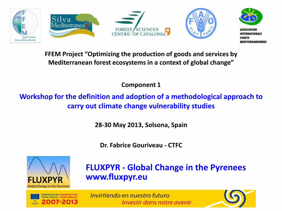
Micro-meteorological stations & high towers….

« Eddy Covariance » – turbulent fluxes
Sonic anemometer
Infrared gaz analyser (CO2, H2O)
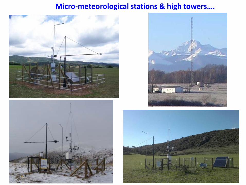
Belowground measurements
Soil humidity Soil temp Soil heat flux

Vegetation sampling (diversity, biomass)
Respiration, photosynthesis & GHG measurements (photoacoustic/Li840)
Soil profiles & sampling
Studies of vegetation, soil and greenhouse gases…

What do we do with the flux data?
Net CO2 fluxes at 2 agricultural sites near Toulouse.
CO2 FLUX < 0 = CO2 absorption (day, full cover)
CO2 FLUX > 0 = net CO2 emission (no cover / respiration > photosynthesis).
The effects of farming practices are visible (CESBIO).

Carbon & GHG balances
(CESBIO, 2010) 13
Inputs
Outputs

CTFC - Jonathan Sanchez, 2010
Soil carbon spatialization

CO2 profiles at different altitudes (IC3) Regional atmospheric CO2 conc., high
tower of La Muela (IC3)
15
ATMOSPHERIC STUDIES
Portable air sampling system (IC3)

Snow cover (CESBIO)
Land cover map (CESBIO)
40%
2%
Soil humidity map – TerraSAR-X
(Baup, CESBIO)
REMOTE SENSING - SATELLITE STUDIES
• Characterize geographical structures & ecosystems dynamics. • Upscale CO2 f luxes (plot > region > continent > global).
LANDSAT, SPOT, MODIS, Pleiades, FORMOSAT ; Radar: ENVISAT, TerraSAR-X
Snow cover probability (CESBIO)

Remote Sensing - UAV, “Unmanned Aerial Vehicle” • CIR cameras (“Colour Infrared”) • Thermal cameras • GPS
17
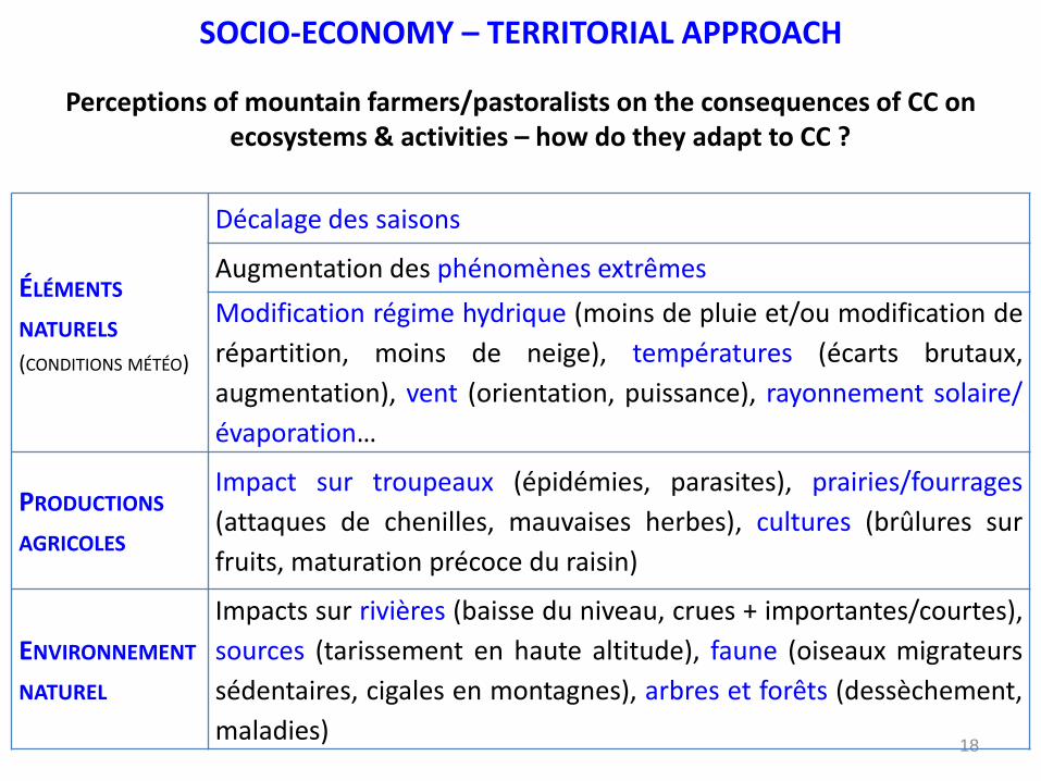
SOCIO-ECONOMY – TERRITORIAL APPROACH
Perceptions of mountain farmers/pastoralists on the consequences of CC on ecosystems & activities – how do they adapt to CC ?
18
ÉLÉMENTS
NATURELS (CONDITIONS MÉTÉO)
Décalage des saisons
Augmentation des phénomènes extrêmes
Modification régime hydrique (moins de pluie et/ou modification de
répartition, moins de neige), températures (écarts brutaux,
augmentation), vent (orientation, puissance), rayonnement solaire/
évaporation…
PRODUCTIONS
AGRICOLES
Impact sur troupeaux (épidémies, parasites), prairies/fourrages
(attaques de chenilles, mauvaises herbes), cultures (brûlures sur
fruits, maturation précoce du raisin)
ENVIRONNEMENT
NATUREL
Impacts sur rivières (baisse du niveau, crues + importantes/courtes),
sources (tarissement en haute altitude), faune (oiseaux migrateurs
sédentaires, cigales en montagnes), arbres et forêts (dessèchement,
maladies)

What can be capitalized & used in the Mediterranean context?
19
• Networking & long term collaboration (sharing data, experiences, resources).
• Common methodologies, harmonized protocols, techniques, tools.
• Data collection & management, analysis, modelling…
Observatoire Pyrénéen du Changement Climatique (www.opcc-ctp.org) (Communauté de Travail des Pyrénées)
Study on adaptation to climate change in the Pyrenees
- Vulnerability study at Pyrenean Scale. - State of CC adaptation in Pyrenees & European mountains. - Recommendations to integrate CC in socioeconomic activities.
Tourism, agriculture/livestock, forests, water, biodiversity, natural risks, health, infrastructures, industry, energy.
20
Thanks for your attention!