Working with GIS: Introduction to ArcGIS. In preparation for the first lab, you will: Be briefly...
33
Working with GIS: Working with GIS: Introduction to Introduction to ArcGIS ArcGIS
-
Upload
elmer-parks -
Category
Documents
-
view
218 -
download
0
Transcript of Working with GIS: Introduction to ArcGIS. In preparation for the first lab, you will: Be briefly...

Working with GIS: Working with GIS: Introduction to ArcGISIntroduction to ArcGIS
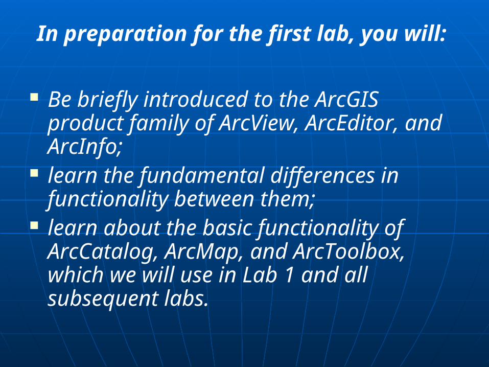
In preparation for the first lab, you will:
Be briefly introduced to the ArcGIS product family of ArcView, ArcEditor, and ArcInfo;
learn the fundamental differences in functionality between them;
learn about the basic functionality of ArcCatalog, ArcMap, and ArcToolbox, which we will use in Lab 1 and all subsequent labs.

Overview of ArcGISOverview of ArcGIS
ArcGIS is a comprehensive, ArcGIS is a comprehensive, integrated, scalable system designed integrated, scalable system designed to meet the needs of a wide range of to meet the needs of a wide range of GIS users. The three desktop GIS GIS users. The three desktop GIS components of ArcGIS are: components of ArcGIS are:
ArcView ArcView ArcEditor ArcEditor ArcInfo ArcInfo
Depending on your requirements, you may Depending on your requirements, you may employ one or a combination of the ArcGIS employ one or a combination of the ArcGIS components across your network. With all components across your network. With all three ArcGIS components, you can view three ArcGIS components, you can view databases managed by ArcSDE, but it's databases managed by ArcSDE, but it's only with ArcEditor and ArcInfo that you only with ArcEditor and ArcInfo that you can write to such databases.can write to such databases.
(ArcSDE is a client/server software program that enables (ArcSDE is a client/server software program that enables spatial data to be stored, managed, and quickly retrieved spatial data to be stored, managed, and quickly retrieved from leading commercial database management systems from leading commercial database management systems (DBMS).)(DBMS).)

All three ArcGIS components are built All three ArcGIS components are built from the same core technology. from the same core technology.
ArcView includes ArcCatalog, ArcMap, and ArcView includes ArcCatalog, ArcMap, and ArcToolbox, which allow you to browse, manage, ArcToolbox, which allow you to browse, manage, analyze, edit, and document your data. analyze, edit, and document your data.
ArcEditor has all the functionality of ArcView plus ArcEditor has all the functionality of ArcView plus powerful tools for editing powerful tools for editing shapefilesshapefiles and and geodatabases. geodatabases.
ArcInfo provides the most functionality and ArcInfo provides the most functionality and includes all of the capabilities of ArcEditor plus includes all of the capabilities of ArcEditor plus additional geoprocessing tools and a full version additional geoprocessing tools and a full version of ArcInfo Workstation (comprised of ARC, of ArcInfo Workstation (comprised of ARC, ArcEdit, ArcPlot, INFO, and ARC Macro Language ArcEdit, ArcPlot, INFO, and ARC Macro Language or AML). or AML).

In this class, we will be working with some of the components in ArcView 8

ArcView 8 is a powerful GIS data ArcView 8 is a powerful GIS data visualization, query, analysis, and map visualization, query, analysis, and map creation solution designed for Microsoft® creation solution designed for Microsoft® Windows NT/2000. It provides interactive Windows NT/2000. It provides interactive tools for tools for exploringexploring, , selectingselecting, , displayingdisplaying, , editingediting, , analyzinganalyzing, , symbolizingsymbolizing, and , and classifyingclassifying data as data as well as for automatically creating, well as for automatically creating, updating, and managing metadata. updating, and managing metadata. ArcView 8 includes ArcCatalog, ArcMap, ArcView 8 includes ArcCatalog, ArcMap, and ArcToolbox. and ArcToolbox.

More details:More details: Additionally, ArcView is "Web-enabled." This Additionally, ArcView is "Web-enabled." This
means you can dynamically browse and retrieve means you can dynamically browse and retrieve geographic data available on the World Wide geographic data available on the World Wide Web. ArcView's File menu has a direct connection Web. ArcView's File menu has a direct connection to the to the Geography NetworkGeography Network. .
Because it is built on COM (Because it is built on COM (Component Object ModelComponent Object Model) technology, you can ) technology, you can customize ArcView 8 either by writing macros in customize ArcView 8 either by writing macros in Visual Basic for Applications (included with Visual Basic for Applications (included with ArcView) or by creating extensions using ArcView) or by creating extensions using standard development environments like Visual standard development environments like Visual Basic, C++, and Delphi. Basic, C++, and Delphi.

ArcView 8 works with all core ArcGIS software products, ArcView 8 works with all core ArcGIS software products, including ArcSDE and ArcIMS. It also works with all new including ArcSDE and ArcIMS. It also works with all new
ArcGIS extension products, including:ArcGIS extension products, including:
Spatial Analyst Spatial Analyst ArcView 3D AnalystArcView 3D Analyst ArcPressArcPress Geostatistical Analyst Geostatistical Analyst StreetMapStreetMap

With ArcView8 you can:With ArcView8 you can: explore, display, and query spatial data explore, display, and query spatial data access a comprehensive suite of editing tools for shapefiles access a comprehensive suite of editing tools for shapefiles
and perform simple feature editing on personal and perform simple feature editing on personal geodatabases geodatabases
perform geoprocessing operations perform geoprocessing operations create presentation-quality maps with a comprehensive create presentation-quality maps with a comprehensive
suite of cartographic tools and wizards suite of cartographic tools and wizards create reports and sophisticated two- and three-create reports and sophisticated two- and three-
dimensional graphs dimensional graphs perform layer-level projection (including imagery) perform layer-level projection (including imagery) create and manage annotation create and manage annotation view maps from the Internet view maps from the Internet import data from and export data to a variety of common import data from and export data to a variety of common
formatsformats

Other ESRI GIS products…

ArcEditorArcEditor ArcEditor is the intermediate ArcGIS application—ArcEditor is the intermediate ArcGIS application—
it provides more functionality than ArcView but it provides more functionality than ArcView but less than ArcInfo—and is designed for less than ArcInfo—and is designed for organizations that employ an enterprise GIS organizations that employ an enterprise GIS system. As its name implies, ArcEditor adds system. As its name implies, ArcEditor adds significant editing functionality to the GIS significant editing functionality to the GIS enterprise. enterprise.
An example of how ArcEditor fits into a GIS An example of how ArcEditor fits into a GIS enterprise solution would be an organization that enterprise solution would be an organization that has one ArcInfo seat and ArcSDE, a relational has one ArcInfo seat and ArcSDE, a relational database management system (RDBMS), a small database management system (RDBMS), a small staff of geodatabase editors using ArcEditor, and staff of geodatabase editors using ArcEditor, and many staff querying and viewing the geodatabase many staff querying and viewing the geodatabase using ArcView. using ArcView.


ArcEditor contains all of the functionality ArcEditor contains all of the functionality of ArcView plus additional functionality for of ArcView plus additional functionality for editing shapefiles and geodatabases. With editing shapefiles and geodatabases. With ArcEditor, you can create and update ArcEditor, you can create and update databases and database schema for databases and database schema for personal and enterprise geodatabases.personal and enterprise geodatabases.
You can also perform advanced You can also perform advanced geodatabase editing, such as adding and geodatabase editing, such as adding and modifying feature behavior, relationships, modifying feature behavior, relationships, and rules. Of course, you also have a and rules. Of course, you also have a complete set of mapping and data query complete set of mapping and data query tools.tools.

ArcInfoArcInfo
ArcInfo is the most powerful and ArcInfo is the most powerful and functionally rich application in the ArcGIS functionally rich application in the ArcGIS product family. In addition to all the product family. In addition to all the functionality included in ArcView and functionality included in ArcView and ArcEditor, ArcInfo includes a complete ArcEditor, ArcInfo includes a complete ArcToolbox application and a full version ArcToolbox application and a full version of ArcInfo Workstation (ARC, ArcEdit, of ArcInfo Workstation (ARC, ArcEdit, ArcPlot, AML, and all extensions). ArcInfo is ArcPlot, AML, and all extensions). ArcInfo is the complete GIS data creation, update, the complete GIS data creation, update, query, mapping, and analysis system. query, mapping, and analysis system.


With ArcInfo, you have open access to With ArcInfo, you have open access to data processing functions so that you can data processing functions so that you can integrate ArcInfo with other applications. integrate ArcInfo with other applications. Because ArcMap and ArcCatalog are based Because ArcMap and ArcCatalog are based on COM (Component Object Model) on COM (Component Object Model) technology, you can model the diversity technology, you can model the diversity and complexity of real-world features and and complexity of real-world features and concepts by assigning rules and behaviors concepts by assigning rules and behaviors to objects. to objects.

The Applications we are going to be working with include ArcCatalog, ArcMap, and ArcToolbox
People typically interact with a GIS through data, maps, and tools.

ArcCatalogArcCatalog Think of ArcCatalog as a window into your Think of ArcCatalog as a window into your
database. In ArcCatalog, you can browse, database. In ArcCatalog, you can browse, organize, distribute, and document your GIS data. organize, distribute, and document your GIS data. ArcCatalog resembles the Microsoft Windows ArcCatalog resembles the Microsoft Windows Explorer but is designed for viewing geographic Explorer but is designed for viewing geographic databases, maps, and metadata. databases, maps, and metadata.
To access data on your computer's hard drives or To access data on your computer's hard drives or your local network, you click the Connect to your local network, you click the Connect to Folder button and navigate to the data. Folder button and navigate to the data. ArcCatalog also includes a Database Connections ArcCatalog also includes a Database Connections dialog to help you access ArcSDE and OLE DB dialog to help you access ArcSDE and OLE DB databases. databases.

The collection of The collection of connections you set up to connections you set up to your geographic data is your geographic data is called the Catalog. The called the Catalog. The Catalog Tree gives you Catalog Tree gives you access to all of the access to all of the Catalog's contents. In the Catalog's contents. In the ArcCatalog window shown ArcCatalog window shown here, the Catalog Tree is here, the Catalog Tree is
on the left side.on the left side.

Inside ArcCatalog there are Inside ArcCatalog there are three tabs, each of which three tabs, each of which provides a unique way to provides a unique way to view the contents of a view the contents of a selected item in the selected item in the Catalog Tree. The Contents Catalog Tree. The Contents tab shows you a list of the tab shows you a list of the selected item's contents. selected item's contents. The Preview tab lets you The Preview tab lets you see the data (both see the data (both geographic and tabular) geographic and tabular) contained in the selected contained in the selected item. The Metadata tab item. The Metadata tab gives you access to gives you access to documentation about the documentation about the selected item.selected item.

There are different ways to preview geographic There are different ways to preview geographic data. You can create thumbnail images of your data. You can create thumbnail images of your data to display it graphically, or you can display it data to display it graphically, or you can display it with large icons, with small icons in list view, or in with large icons, with small icons in list view, or in details view which displays small icons and the details view which displays small icons and the data's properties. data's properties.
It is important to keep records of your GIS data It is important to keep records of your GIS data inventory. You may need information about the inventory. You may need information about the data's accuracy or how a set of measurements data's accuracy or how a set of measurements was collected. An item's metadata includes this was collected. An item's metadata includes this type of documentation, along with many type of documentation, along with many properties derived from the data automatically. properties derived from the data automatically. ArcCatalog provides metadata editors, which you ArcCatalog provides metadata editors, which you can use to create, edit, and view metadata.can use to create, edit, and view metadata.

ArcMapArcMap ArcMap is the application you use to view and ArcMap is the application you use to view and
edit geographic data and create professional-edit geographic data and create professional-quality maps, graphs, and reports. quality maps, graphs, and reports.
A map is the fundamental component you work A map is the fundamental component you work with in ArcMap. Maps help you visualize with in ArcMap. Maps help you visualize geographic data by showing you where things are geographic data by showing you where things are and what they look like. You can drag and drop and what they look like. You can drag and drop data from ArcCatalog directly into ArcMap. When data from ArcCatalog directly into ArcMap. When you want to work with a map, open ArcCatalog, you want to work with a map, open ArcCatalog, find the desired map document, and simply drag find the desired map document, and simply drag it onto the ArcMap display area. it onto the ArcMap display area.

Geographic information is Geographic information is displayed on a map as layers, displayed on a map as layers, where each layer represents a where each layer represents a particular type of feature. In particular type of feature. In ArcMap, the Table of Contents ArcMap, the Table of Contents lists all the layers shown on the lists all the layers shown on the map. By default, the Table of map. By default, the Table of Contents is located on the left Contents is located on the left side of the ArcMap application side of the ArcMap application window, but you can move it to a window, but you can move it to a different position if you like. The different position if you like. The order of layers within the Table of order of layers within the Table of Contents is important; the layers Contents is important; the layers at the top of the Table of Contents at the top of the Table of Contents draw on top of the layers below draw on top of the layers below them. Thus, you should put the them. Thus, you should put the layers that form the background layers that form the background of your map, such as the ocean, of your map, such as the ocean, at the bottom of the Table of at the bottom of the Table of Contents. Contents.

Sometimes, however, just looking Sometimes, however, just looking at a map isn't enough. You need at a map isn't enough. You need to find specific information about to find specific information about features on the map to solve features on the map to solve problems. In ArcMap, just by problems. In ArcMap, just by pointing and clicking on features, pointing and clicking on features, you can find out what they are you can find out what they are and access the information about and access the information about them that's contained in the them that's contained in the database. database.
ArcMap makes it easy to design ArcMap makes it easy to design maps for printing, embedding in maps for printing, embedding in other documents, or publishing other documents, or publishing electronically. For some data, electronically. For some data, other presentation methods are other presentation methods are more effective than a map. more effective than a map. Graphs and reports can show at a Graphs and reports can show at a glance the information of interest. glance the information of interest. ArcMap provides many options for ArcMap provides many options for creating sophisticated graphs and creating sophisticated graphs and reports. reports.

ArcToolboxArcToolbox
ArcToolbox is the application you use to ArcToolbox is the application you use to perform advanced GIS analysis tasks and perform advanced GIS analysis tasks and sophisticated geographic data processing sophisticated geographic data processing jobs, like projecting your data or creating jobs, like projecting your data or creating and integrating a variety of data formats and integrating a variety of data formats into usable GIS databases. If you've into usable GIS databases. If you've identified the datasets you want to work identified the datasets you want to work with in ArcCatalog you can drag and drop with in ArcCatalog you can drag and drop them into ArcToolbox or you can use them into ArcToolbox or you can use ArcToolbox's browse functions to locate ArcToolbox's browse functions to locate the datasets you want to use. the datasets you want to use.


Using the Add a Custom Tool wizard, you can add your own Using the Add a Custom Tool wizard, you can add your own custom tools to ArcToolbox. The tools you create must have a .exe custom tools to ArcToolbox. The tools you create must have a .exe or .dll extension. or .dll extension.
ArcInfo's ArcToolbox contains a more extensive set of tools (over ArcInfo's ArcToolbox contains a more extensive set of tools (over 140) compared to the ArcToolbox included with ArcView and 140) compared to the ArcToolbox included with ArcView and ArcEditor. With ArcInfo's ArcToolbox, you can convert virtually all ArcEditor. With ArcInfo's ArcToolbox, you can convert virtually all major spatial data formats. You can generate and maintain major spatial data formats. You can generate and maintain topology; join, clip, and split map sheets, and use advanced topology; join, clip, and split map sheets, and use advanced modeling tools. It also provides wizard interfaces for complex modeling tools. It also provides wizard interfaces for complex tasks like data conversion, overlay processing, buffer creation, tasks like data conversion, overlay processing, buffer creation, projection, and map transformation. projection, and map transformation.
ArcInfo's ArcToolbox provides a link to ArcInfo Workstation's ARC, ArcInfo's ArcToolbox provides a link to ArcInfo Workstation's ARC, ArcEdit, and ArcPlot because it seamlessly accesses their ArcEdit, and ArcPlot because it seamlessly accesses their functionality through the Open Development Environment (ODE). functionality through the Open Development Environment (ODE). This also allows ArcInfo users to execute existing AML programs in This also allows ArcInfo users to execute existing AML programs in addition to system executables and DLL files. addition to system executables and DLL files.

HELP!! HJELP!! AYUDA! HILFE!HELP!! HJELP!! AYUDA! HILFE!
Learning a new software product can be Learning a new software product can be frustrating without useful online documentation. frustrating without useful online documentation. ArcGIS online help provides comprehensive ArcGIS online help provides comprehensive explanations of procedures, tools, buttons, and explanations of procedures, tools, buttons, and commands. commands.

The ArcGIS Desktop Help The ArcGIS Desktop Help consists of a help viewer with consists of a help viewer with two panes: a navigation pane two panes: a navigation pane (on the left) and a topic pane (on the left) and a topic pane (on the right). The navigation (on the right). The navigation pane has four tabs: Contents, pane has four tabs: Contents, Index, Search, and Favorites. Index, Search, and Favorites. The topic pane is for viewing The topic pane is for viewing help topics.help topics.
Clicking the Contents tab displays the Table of Contents for Clicking the Contents tab displays the Table of Contents for help topics. You can see general topics and how they are help topics. You can see general topics and how they are organized. organized.
Clicking the Index tab allows you to search through the Clicking the Index tab allows you to search through the index for topics by entering one or more keywords, such as index for topics by entering one or more keywords, such as "Layer" or "Table." "Layer" or "Table."
Clicking the Search tab allows you to find every help topic Clicking the Search tab allows you to find every help topic containing a word or phrase that you specify, whether the containing a word or phrase that you specify, whether the word or phrase is in the index or not (of course, it will take word or phrase is in the index or not (of course, it will take longer if it's not in the index). longer if it's not in the index).
Clicking the Favorites tab allows you to create a Clicking the Favorites tab allows you to create a personalized list of favorite help topics. The list is saved and personalized list of favorite help topics. The list is saved and appears each time you open the help system. appears each time you open the help system.

Clicking on a topic in the Contents tab opens that Clicking on a topic in the Contents tab opens that topic in the topic pane on the right. In the Index, topic in the topic pane on the right. In the Index, Search, and Favorites tabs, clicking the Display Search, and Favorites tabs, clicking the Display button opens the selected topic. button opens the selected topic.
In ArcCatalog, ArcMap, and ArcToolbox, button In ArcCatalog, ArcMap, and ArcToolbox, button and tool names are displayed when you move the and tool names are displayed when you move the mouse over them (these are called tool tips). mouse over them (these are called tool tips). Additionally, you can click the What's This? Additionally, you can click the What's This? button, then click a button or tool to access button, then click a button or tool to access
additional help about itadditional help about it (this is called context-(this is called context-sensitive help).sensitive help).