Working Paper 130 - India Environment Portal | News, … Paper 130 ZEF ISSN 1864-6638 Bonn, May 2014...
38
Working Paper 130 ZEF ISSN 1864-6638 Bonn, May 2014 Metabolized-water breeding diseases in urban India: Socio-spatiality of water problems and health burden in Ahmedabad Saravanan, V.S., Mavalankar, D., Kulkarni, S., Nussbaum, S. and Weigelt, M.
Transcript of Working Paper 130 - India Environment Portal | News, … Paper 130 ZEF ISSN 1864-6638 Bonn, May 2014...

Working Paper 130
ZEF
ISSN 1864-6638 Bonn, May 2014
Metabolized-water breeding diseases in urban India: Socio-spatiality of water problems and health burden in Ahmedabad
Saravanan, V.S., Mavalankar, D., Kulkarni, S., Nussbaum, S. and Weigelt, M.

Cover photos: Top-left: Water storage in unhygienic containers Top-right: Sewerage lines encroached over by households Bottom-left: Drinking water, sewerage, storm water and electric pipe lines exposed making it hazardous Bottom-right: High rise apartments with their own water infrastructure

ZEF Working Paper Series, ISSN 1864-6638 Department of Political and Cultural Change Center for Development Research, University of Bonn Editors: Joachim von Braun, Manfred Denich, Solvay Gerke and Anna-Katharina Hornidge Authors’ addresses V. S. Saravanan, Senior Researcher, Center for Development Research (ZEF), University of Bonn, Walter-Flex-Str. 3 53113 Bonn, Germany Tel. 0049 (0)228-73 4918: Fax 0228-731972 E-mail: [email protected] www.zef.de Dileep Mavalankar, Dean (Academic), Indian Institute of Public Health-Gandhinagar, Ahmedabad 580054, India. Tel. 0091(0)79-40240444: Fax: 0091 - 79 - 40240445 E-mail: [email protected] Suhas P. Kulkarni, Medical Officer, Ahmedabad Municipal Corporation, Ahmedabad, India. E-mail: [email protected] Sven Nussbaum, Coordinator, Center for Remote Sensing of Land Surfaces, University of Bonn, Bonn, Germany. E-mail: [email protected] Martin Weigelt, Department of Geography/Center for Remote Sensing of Land Surfaces, University of Bonn, Bonn, Germany. E-mail: [email protected]

i
Metabolized-water breeding diseases in urban India*:
Socio-spatiality of water problems and health burden in Ahmedabad
Saravanan, V. S., Mavalankar, D., Kulkarni, S., Nussbaum, S. and Weigelt, M.
*A modified version of this paper is forthcoming in the Journal of Industrial Ecology
ii
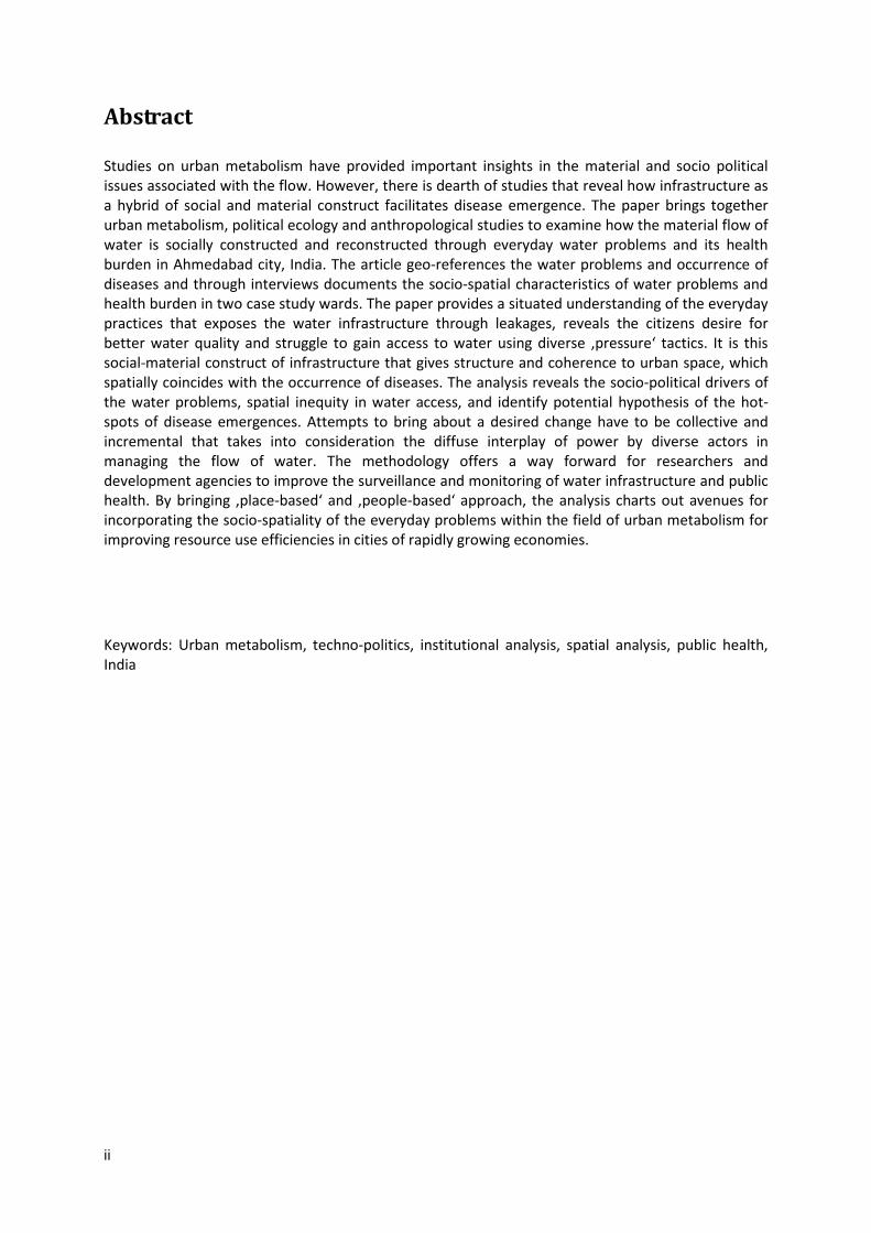
Abstract
Studies on urban metabolism have provided important insights in the material and socio political issues associated with the flow. However, there is dearth of studies that reveal how infrastructure as a hybrid of social and material construct facilitates disease emergence. The paper brings together urban metabolism, political ecology and anthropological studies to examine how the material flow of water is socially constructed and reconstructed through everyday water problems and its health burden in Ahmedabad city, India. The article geo-references the water problems and occurrence of diseases and through interviews documents the socio-spatial characteristics of water problems and health burden in two case study wards. The paper provides a situated understanding of the everyday practices that exposes the water infrastructure through leakages, reveals the citizens desire for better water quality and struggle to gain access to water using diverse ‚pressure‘ tactics. It is this social-material construct of infrastructure that gives structure and coherence to urban space, which spatially coincides with the occurrence of diseases. The analysis reveals the socio-political drivers of the water problems, spatial inequity in water access, and identify potential hypothesis of the hot-spots of disease emergences. Attempts to bring about a desired change have to be collective and incremental that takes into consideration the diffuse interplay of power by diverse actors in managing the flow of water. The methodology offers a way forward for researchers and development agencies to improve the surveillance and monitoring of water infrastructure and public health. By bringing ‚place-based‘ and ‚people-based‘ approach, the analysis charts out avenues for incorporating the socio-spatiality of the everyday problems within the field of urban metabolism for improving resource use efficiencies in cities of rapidly growing economies.
Keywords: Urban metabolism, techno-politics, institutional analysis, spatial analysis, public health, India

1
1 Urban Water Infrastructure: Flows, Politics and Semiotics
Urban water infrastructure plays a crucial role in securing public health (Alirol et al., 2011). The impact of poor water supply and sanitation on human health are well-documented in cities of rapidly growing economies (McGranahan et al., 2001; Agtini et al., 2005; Kolahi et al., 2010; Makwana, 2012; Saravanan & Gondhalekar, 2013; Schmidt, 2014). Although water infrastructure is known to influence human health, there is a dearth of studies that reveal how flow of water is transformed or metabolized by diverse actors to facilitate disease emergence. The article examines the everyday construction and reconstruction of water infrastructure by diverse actors engaging with water problems and its health burden in Ahmedabad city, India. Infrastructures are built networks that facilitate flows of goods, people or ideas and allow for exchange over space (Larkin, 2013). Arising out of the industrial ecology, urban metabolism has contributed to analyzing the material flow of water to allocate the resources efficiently (Kennedy et al., 2012) and offered new ways of thinking about the sustainability of cities and opportunities for innovative urban infrastructures (Broto et al., 2012). Urban metabolism through its interdisciplinary perspective had offered a fruitful avenue to investigate urban transformation through diverse tools for development of social and environmental policy and, investigate the role of actors and power relations that shapes urban space. Despite its insights, they inform little about the ‘everyday practices’ of infrastructure (Graham and Thrift, 2007; Lawhon et al., 2013), the diffuse forms of power and more so less on policy planning and designing of urban infrastructure. Infrastructure is an amalgam of technical, administrative and financial techniques that places systems at the centre of the analysis and focuses on system building (Larkin, 2013). This echoes, Latour’s (2004) hybridization concept that shows how infrastructure is embedded in spatial, temporal and social practices and discourses are negotiated in everyday practices (cited in Zimmer, 2010:347). A situated understanding of the flow, power and knowledge in everyday practice forms the core towards alternative possibilities for progressive change (Lawhon et al., 2013). More so exploring the flow through the everyday practices of claim-making by actors will help to build a theoretical understanding of the southern urbanism (Lawhon et al., 2013). Coming from a technopolitics perspective, Larkin (2013) identifies concrete semiotic and aesthetic elements of everyday problems to analyze infrastructure. These elements are not separate from the purely technical functions, but are forms of expression though which politics is constituted. These include historical evolution, the aesthetics of the infrastructure and the “pressure” to access water (Larkin, 2013). Examining the historical setting places the infrastructure as a product in the contemporary context and captures the evolutionary thinking of how to bring about changes for enacting progress (see Bakker et al., 2008; Chaplin, 2011). Aesthetics generates much of the citizenry’s sense of modernity and progressiveness, and cultivates technical skills and knowledge as a way of fulfilling the desire for efficient systems. This can be analyzed in two ways (Larkin, 2013): (i) how the systems and practices operate in comparison to their purported objectives (herein it refers to water leakage, compared to efficient water supply through pipelines), and; (ii) how the infrastructure embodies the experience of everyday life, through taste, touch, hearing, seeing, and smell (herein it refers to the perceived water quality). The pressure reveals how diverse social groups struggle through social network and technologies to gain access to unequal and scarce water (Anand, 2011). These elements of everyday water problems represents a product that includes decay, but is also rightly regarded as central to the creation of new forms of urban life (Graham & Thrift, 2007) that has significant influence on the human health. The article contributes by understanding how the historical legacy and contemporary policies facilitate the socio-spatial inequality of urban water in Ahmedabad; how these inequalities are challenged through every day practices of reporting water problems; and what implication does

2
these have on the human health in two case study administrative wards – dubbed Ward A and Ward B (The names of these wards are kept anonymous to maintain confidentiality of the region) – in Ahmedabad, India. The following section provides an overview of the historic and contemporary settings that influences the way urban water is managed making residents vulnerable to health consequences. The third section provides the methodological details of the study and the steps taken in the spatial analysis. The fourth section elaborates on the socio-spatiality of: (1) the water leakage from pipelines; (2) the poor quality of drinking water; and (3) low pressure in the drinking water pipelines, as reported from the consumer end. These perspectives help us to understand the flow of water as interdependency between social actors, institutions and biophysical system. The final section highlights the role of emerging hydraulic diseases that plagues urban societies calling for significant innovation in the infrastructural governance. Drawing spatial coincidences between the water problems and health does not exclude other factors (e.g., socio-cultural and economic factors, hygiene and access to basic services) that are equally important (WHO/UN Habitat, 2010) in influencing health, but attempts to demonstrate the increasing role of infrastructure in influencing public health in rapidly-urbanizing economies such as India.

3
2 Ahmedabad: Water Infrastructure in a Segregated City
Ahmedabad represents one of the rapidly urbanizing economies in India. The overall population increased from a mere 837,000 in 1951 to 5.6 million in 2011 (UMC, 2012). To meet the growing drinking water needs, the city supplies a daily average of around 1030 MLD, or about 148 lpcd (UMC, 2012) of which surface water accounts for 90% of the supply and 10% with ground water. There are very few areas where tankers supply water. The city has been able to supply around 148 lpcd (liters per capita per day) to about 88% of its population, with a daily supply at the consumer end being 2.25 hours (UMC, 2012). In spite of this coverage there is recurrence of water- and vector-borne diseases in the city (Saravanan, 2013). The city is plagued with spatial inequality which is deeply embedded in the pre-colonial textile-based economy and in the colonial legacy of segregated planning, which are actively exploited by diverse actors using public goods to benefit private interest (Chaplin, 2011; Saravanan, 2013). Currently, the city’s settlement can be divided into informal settlements, chawls, housing societies, largely of low-income to middle-income groups, and independent housing complexes, a configuration that reflects the hierarchy from informal settlements to independent housing complexes in the levels of living, quality of housing and availability of basic services (Mahadevia, 2002:4851). To improve the water systems, the Corporation has prepared a Sanitation Plan (UMC, 2012) as per the requirement of the Jawaharlal Nehru National Urban Renewal Mission (JnNURM) a national level program to modernize the cities in India. These plans provide status quo of the water supply and sanitation situation rather than the social, institutional and physical complexities in everyday practice of water management. By taking a closer look at two administrative Wards in the city, the article reveals the social, institutional and physical complexities in the everyday practice of water management, and its health burden among urban residents. Ward A had a population of 91,000 in 2011, situated in what are officially classified as “slum or slum-like” settlements (as they do not have legal land tenure). It was a thriving textile centre during the pre-colonial and colonial periods; it is now occupied by chawls, informal settlements, few housing societies, abandoned industries, solid waste disposal site, wastewater treatment plant and vast stretches of agricultural land. The land use of the ward is distinct in the north and in the south (as in Appendix 1). The northwestern and western parts of the ward consist of linear housing (chawls) bordering the industrial land, abandoned due to the neo-liberal policies of the 1980s and 1990s. Given their unclear land tenure status in chawls, households illegally connect to water pipes (constructed for public standpipes) and discharge their household waste outside their homes or into open drains. In the northeastern portion of the ward, there are housing societies with highly dense water networks, connected through public standpipes and private connections. Many of these housing societies have private water and sewerage connections through piped network. By contrast, the southern part is considered as a “no man’s land” where no information on habitation is available; the area has agricultural land, a waste-water treatment plant (southeast of the ward) one of the city’s solid waste disposal, and a vast plot of land occupied by squatter settlers. Given a lack of information, analysis could not be carried out for this part of the ward and hence the following maps depict only the northern part of the ward. The Ward B has a population of 86,000 in 2011, 70% of whom lived in informal settlements occupied in public or private lands. Ward B was included in the city in the 1960s as a planned settlement to provide low-cost housing to the textile mill workers and employees when Ahmedabad was still a flourishing textile centre. With the closure of the mills in the 1980s and 1990s, many people remained unemployed, sought self-employment or were absorbed into the diamond-cutting industry that grew from the 1990s onwards. The diamond industry and the growing economy of Ahmedabad further increased the population. A large part of the housing within this ward was planned and built
4
by the Gujarat Housing Board (though a government program for providing housing to diverse income groups targeting low and middle-class households) for the workers of former textile mills (as in Appendix. 2). In recent years, private real estate companies have developed properties (sometimes illegally occupying common lands, as in this case in northwest), and a number of squatter settlements now surround the lake in the ward. While these informal settlements have certainly encroached on public lands, a number of households within the planned settlement also impinge on public roads; as in Ward A. Some even extended above the drainage and drinking water pipelines. The department of engineer (DoE), AMC has often had to seal off drinking water lines and re-lay the pipe in different areas, as they are politically unable to evict the trespassers. Most of them have access to drinking water and sanitation provided by the DoE through piped network. Aging infrastructure, poor alignment of pipelines, water logging and illegal drinking water connections are major hurdles to ensuring safe drinking water, adequate sanitation and effective disposal of sewerage waste.

5
3 Methods and Analysis
Information on water infrastructural networks is elusive in the Wards, like any other global south, where data on water infrastructure is scarce. The maps of the pipelines in the ward dates back to 1970’s, and there is no clear understanding of how much water is supplied in the Wards, the quality and the diameter of these pipelines. In contrast, there is wealth of information on the complaints reported by households, and experiences from the lineman and contract laborers working with DoE over a decade. The information on the water leakages, water quality and water pressure was collected from Complaints Register Book maintained by the DoE, where households register their everyday complaints about road, water, sewerage and other public works issues. The report is an important documentation that makes the infrastructure visible through everyday water problems. The register runs several hundred pages, and there are four or five books per year. The register contains information about the complainant (name and address), the nature of the complaint, the location of the complaint (address or landmark) and the remarks of the junior engineer on whether the reported case has been addressed. These complaints are based on the people’s everyday experiences and observations in their settlements. The information in these registers is not compiled in any way (for politically convenient reasons) for precautionary decision-making, excepting as a ‘fire-fighting’ approach by junior engineers to address day-to-day complaints, so it had to be documented and geo-referenced manually. The water network map was prepared by updating the 1970s engineering drawing available from the DoE through transit walks with the junior engineer, lineman and contract laborers employed by the DoE. Preparation of the network reveals a lack of technical expertise among the engineers, in identifying and describing the piped network. Junior engineer positions have a high rate of transfer, so they have a limited knowledge of the networks and their conditions; they are often patched up by a lineman who has decades of experience and contacts with the urban residents in the ward. Using Google Maps and the administrative ward maps as a basis, the 1970s network map was updated through transit walks with the lineman. This process allowed us to chart the direction of flow, dimension of the pipes and specific problems occurring in these networks. The exercise was limited to mapping the legal water lines, but there are a vast number of illegal water networks, and different types of (piped, open-pit drain and overflowing) sewerage lines, which the research team found it very sensitive and difficult to map given the resources at hand. The sewerage and storm water pipelines were sparse in the two wards, revealing how disconnected drinking water, sewerage and storm water lines exists in urban India, and also the reason for urban population drowning in their own sewage. Given the availability and its importance to health the analysis used the drinking water network for analysis. The settlement map was prepared based on the administrative map provided by the local authority, and field-tested through observation and interviews with local officials and urban residents. The occurrence of diseases was georeferenced from the information gathered at the urban health centre in the ward and the health statistics unit, under the Department of Health (DoH), AMC. The department uses both active and passive surveillance, among other methods, to collect health information. Active surveillance involves a legion of health workers (known as “link workers” who cover around 1,000 population in a settlement) making door-to-door visits to every household in their jurisdiction to determine the health status of the households. If any symptoms or diseases are noted, the workers give a preliminary dosage of medicine or refer residents to nearby hospitals. Information on the confirmed cases of any disease is entered in the hospital records of the Urban Health Centre. Passive surveillance, on the other hand, involves reporting the number of patients (as well as their ages and addresses) visiting the public and private hospitals and clinics within the ward. The passive number thus includes only the confirmed cases. The data from active and passive surveillance are combined to form the city health statistics. Although surveillance is effective, underreporting is still widespread. Geo-referencing of the health information was available only for gastroenteritis, jaundice and malaria data in Ward A and for jaundice and malaria data in Ward B for

6
the period between July 2011 and December 2012. The georeferenceable information for Ward A represented 22%, 34%, and 24% of the total reported cases of malaria, jaundice, and gastroenteritis respectively, in the ward. The same for Ward B represented 81% and 74% of the total reported cases of malaria and jaundice respectively. The research team documented and geo-referenced the complaints on water infrastructure for 2011 and 2012 and superimposed them on the settlement map to visually describe the relationship. The spatial analysis was applied from July 2011 to December 2012 due to concurrent availability of geo-referenced information for water problems and occurrence of diseases. The article applied the kernel density method to visualize the point data of water problems and the occurrence of diseases in this article. This method provides an overview of the distribution of water problems and the distribution of diseases through density and hotspot mapping. The kernel density method calculates the density of water problems and the density of the occurrence of diseases using a kernel function by taking into account the surrounding neighborhood in the analysis (Silverman, 1986). The density is represented by the amount of cases per hectare; the more cases per hectare, the higher the density. While the kernel density method can be used to provide an overview of the spatial distribution of a phenomenon, it does not explain the significance of the clustering in comparison to the entire research area. Hotspot analysis was applied to determine significant clusters in the occurrences of water problems and the diseases over the spatial settlement pattern. A hotspot needs to fulfil three conditions: it has to be an area with a high number of cases; this area should be surrounded by areas that also have a high number of cases; and this clustering should be statistically significant in comparison to cases in the entire research area. The significance level is usually expressed as a confidence level reaching 90% to 99%. A confidence level of 99% means there is only a 1% chance that this spatial clustering has occurred randomly (For more information regarding applied hotspot methodology, known as the Getis-Ord Gi, (see Getis and Ord, 1992; Ord and Getis, 1995). After mapping the hotspots, we hypothesized that there is a spatial coincidence between the hotspots of diseases and the hotspots of water problems. To identify a possible spatial relation, we applied Pearson correlation analysis to the spatial distribution of the clustering properties (Getis-Ord Gi * z scores) of each disease and WI incident type. The correlation coefficient r quantifies the spatial relationship using a range from -1 to 1. If the r of the spatial clustering properties/distribution of diseases and WI-related problems is closer to 1, then the spatial relationship is stronger. The correlation coefficient r and its level of significance (p-value) were calculated using the statistical software SPSS (Version 21).

7
4 Socio-spatiality of water problems and health burden
The flow of water in the ward coincides with the hierarchy of settlements in both the wards. The head-reach of the network has higher density of networks, where households lived in bungalows and in housing societies, suggesting that these settlements have better access to drinking water. As the network reaches its tail-end, the density decreases and leads to mushrooming informal settlements, which presumably have less access to drinking water. In Ward A, the head-reach area of the water distribution network has a moderate network density that is concentrated around the bungalows (as in Figure. 1, also Appendix. 1). In the middle-reach the network density increases as it becomes dominated by the housing societies in the north and northeast of the Ward. The network density decreases in the east central part of the ward, as it passes the main road surrounded by the chawls that border the vacant industrial areas. In the tail-end, the network tapers and reduces in density, in areas dominated with informal settlements (the western, southwestern and central parts of the ward). The network density around the chawls is moderate, likely due to their location along the boundaries of the industries, which often coincide with main roads. In Ward B, the main distribution pipeline is laid along the main north-south road of the ward (as in Figure 2, also Appendix. 2). The network branches out from the main road to the housing societies, where the density increases. As the network reaches its tail end with low density, there is a concentration of the informal settlements surrounding the central, the northeast and south central parts of the ward. Informal settlements tend to concentrate around the lake, as the availability of open space is convenient for squatting, the lake serves as a nearby water source and there is exposed land for open defecation. Being a planned settlement, Ward B in general showed a higher density of networks compared with Ward A. The distribution of the legal water network and its density is an indicator of the level of access to water for households in both the wards.

8
Figure 1: Land Use and Water Network Density - Ward A

9
Figure 2: Land Use and Water Network Density - Ward B
4.1 Leaking networks – Filthy environment
The spatial grids reporting high density of water networks reported higher incidences (hotspots) of water leakage (as in Appendix 3). It is interesting to note that in areas reporting lesser dense water networks also revealed higher incidences of water leakage, indicating many illegal water connections in areas around informal settlements where households tamper with pipelines resulting in water leakage. In Ward A, the water leakages are concentrated around the chawls in the north, in the informal settlements of the central and western portions, and in housing societies adjoining the informal settlements in the north. In Ward B, water leakages are concentrated in the chawls in the southeast, at road junctions and around informal settlements in the central eastern and southeastern areas of the ward. Leakages are a menace for both the people and the city engineers; when the pipelines are encroached upon by the residents. Encroachment is so rampant, that many of the residents are living on top of the sewerage and drinking water lines, a highly dangerous situation. Frequent deaths due to the release of poisonous gas from the sewerage lines are widely reported (The Times of India, 2013). The situation is not different in chawls and informal settlements where water leakage added by with water logging during rainy days are conducive for breeding vectors, expose people to contaminated water. Grabbing of public space and water resources prevents engineers from carrying out any maintenance activities.

10
Elected boards in the housing societies take care of the water problems in the lower-and middle-class households, by mediating between households and state authorities. In contrast, it is the political workers (in very few settlements, the households in informal settlements have formed societies) who are “caretakers” in chawls and informal settlements that have many illegal water connections in the ward, who mediate between households and state authorities through their (political) leader. At the same time they also legitimize and protect the illegal water connections. The elected boards in housing societies and political actors make claims over this infrastructure to reveal their political role and legitimize their residents’ tactics to access water. The leakage increases the chances of sewage contamination in drinking water pipelines that makes the households vulnerable to gastroenteritis and jaundice. Overflowing sewage water contaminates the drinking water pipes, leading to puddles, where children and even adults in informal settlements and chawls get exposed to the spreading bacteria and other pathogens. This phenomenon, combined with rain waters and open defecation in these settlements, allows flies and pests to breed in the water pools. The DoE and the Medical Department at the AMC are often blamed for poor urban health. One of the junior engineers pointed out, “given the strong nexus between politicians, our bureaucrats and the urban poor, it is impossible for us to evict these people and rehabilitate the existing networks.”
4.2 The ‘Pepsi’ waters: Injecting polluted water
The drinking water quality complaints reveal the people’s desire to access good-quality water. As a former municipal councilor of a ward put it, the households receive “Pepsi-like water,” with a black color, similar to soft drinks, visible for the first few minutes of the two hours of water supply. It is not just the color but also the accompanying smell that makes the water undrinkable. Poor water quality hotspots are found to be around the chawls and in informal settlements (as in Appendix 4). Few hotspots are also found around housing societies that are adjoining the chawls and informal settlements, indicating probable contamination across settlements. In Ward A, the hotspots of poor water quality are around the chawls in the north and in the informal settlements in the west and the central area. In Ward B, the hotspots are around the informal settlements built by private developers in the eastern central area (that is considered to be illegal settlement by the AMC), and to a lesser extent in the planned areas. Interestingly, poor quality of water was not an issue for the informal settlements around the lake in Ward B. Early-morning (just after 6.00 AM when the water is released) visitors to chawls and informal settlements witness many households using cloth, stained brownish from continual exposure to the water, to filter the sediments and foul-smelling water. The absence of this ritual does not mean that housing societies receive a higher grade of water; rather, they have enough resources to treat the water in-house (e.g., with aqua guards and reverse osmosis plants). A former councilor for Ward A states that foul water is one of the reasons for their ward reporting one of higher incidence of gastroenteritis than the city average. The incidence rate of gastroenteritis in this Ward was 379 compared to city average of 100 in 2012. The former councilor insists that, after regular petitioning, in the last few years the corporation has been replacing the old pipes in Ward B. The task was not easy; the DoE’s junior engineer reports that evicting the encroachers, who are often supported by this councilor’s political workers, is a highly challenging duty without which “we cannot guarantee the quality of water in these wards”. A junior engineer revealed that the problem of poor water quality occurs due to contamination between the distribution point of the treated water and the receiving end in the household. Chaotic alignment of water and sewerage pipelines caused by encroachment, aging pipelines and illegal water connections remains the main cause. The junior engineer explained that the distance between the drinking water and sewerage pipelines should be at least 1 foot. Contradictory to engineering specifications, many current networks (especially the tertiary pipelines) were less than 1 foot apart, sometimes adjoining to each other, with one pipe above or below the other (the research team were
11
informed that in some areas, the drinking water pipelines actually goes through the sewerage pipelines that has a larger diameter, but we did not come across them in the survey). The close spacing of these pipelines has severe consequences on public health. As the drinking water flows through gravity, it has low or no pressure throughout the day, excepting during the two hours water supply in a day. By contrast, the sewerage lines are always full and have high pressure throughout the day, as these pipes are at least 50 years old catering to the then population and are not able to accommodate the current demand. Therefore the sewerage lines are always full. All these pipelines have rubber joints, which expands and contracts due to high diurnal variation in the temperature (average diurnal temperature range to about 10 degrees in winter and summer), creating the space for leakage. Because of the close proximity of the pipelines, the high-pressure water from the sewerage pipelines easily enters the drinking water pipes when there is no water flowing during for much of the day. This unhealthy mixing increases when the pipes are old, when rains cause waterlogged ground, when pipelines are tampered during illegal connections, during summer’s higher intake and when domestic or industrial wastewater is disposed off in an open area. Water logging is common in the chawls, in the informal settlements and in the housing societies adjoining them, often in low-lying areas that encourage the breeding of pathogens. Water logging in the chawls and informal settlements could contribute to higher incidence rates of gastroenteritis and jaundice.
4.3 Low water pressure - less pressure on diseases
Pressure is important for the urban authorities who construct high rise water tanks to ensure water flows to every household with the use of gravity. Households tend to gain more access to the water using various strategies. Households living in bungalows and housing societies use pumps to draw more water and use storage tanks to store excess water for their daily need. These settlements have concrete structures and enough money to install pumps and construct storage tanks inside their houses. The hotspots of the low pressure are distributed around them (as in Appendix. 5). Given that they have legal water connections, they tend to report low water pressure and they also report fewer diseases. Interestingly, pressure is not an issue around the Chawls and informal settlements in either ward. The chawls and informal settlements often regard low water pressure as a fact of life and do not report much about it, as many of them have illegal connections. One chawls resident complained that they store water in buckets and drums (in unhygienic conditions), and cannot install pumps in their house, as they depend on public standpipes. Some of them who have (illegal) connections cannot install pumps inside their house, as neighbors would question and report them to engineers or political workers. This situation differs from the housing societies with concrete buildings that muffle sound so that pumps operate without the knowledge of neighbors. Pressure tactics play well with the lower- and middle class households in the housing societies, but not in the chawls and informal settlements. The lineman for the DoE claims that, to improve flowing water pressure for the chawls and informal settlement households, residents sometimes lower their pipe connections beneath the main pipeline, and lower their sump (or the water collection point) underground (a few households are even reported to have underground storage tanks beneath their houses). Though these strategies may enable them to obtain a little more water it runs the risk of getting contaminated with rainwater, overflowing sewage water and run-off from roadside waters. Low water pressure was less significantly related to the occurrence of gastroenteritis, jaundice and malaria in both wards. Water leakage, poor water quality, and low water pressure makes the city water problems visible and vulnerable to urban households to health burden. The occurrence of water problems spatially coincides with the distribution of diseases (Table 1; as in Figure. 3 and 4). Of the three water

12
problems examined in Ward A, poor water quality and water leakage had a significant correlation (with r value of more than 0.60) to all the three diseases examined, compared to low water pressure (with r value less than 0.60). Of the three diseases, gastroenteritis showed a stronger correlation (with r value 0.76) to poor water quality, and jaundice showing a stronger correlation (with r value 0.76) to water leakage. The stronger correlation could only be explained due to infectious nature in a particular context. In Ward B, due to absence of gastroenteritis data, jaundice showed significant correlation (with r value 0.65 and 0.51) to poor water quality and water leakage, respectively, compared to low water pressure. Malaria was significantly correlated to water leakage, probably water logging allowing breeding sites for mosquitoes. Comparatively Ward A displayed stronger spatial coincidence of diseases to water problems, compared to Ward B. This could probably be due to higher informal and chawls types of settlement and proximity of solid waste disposable site, wastewater treatment plant and vast agriculture land.

13
Tab 1: Spatial correlation of water problems and health burden in Ward A and Ward B
Ward A Ward B
r
Level of
Significance r
Level of
Significance
Water Leakage
Gastroenteritis 0.68 0.01 NA NA
Jaundice 0.76 0.01 0.51 0.01
Malaria 0.69 0.01 0.37 0.01
Poor Water Quality
Gastroenteritis 0.76 0.01 NA NA
Jaundice 0.69 0.01 0.65 0.01
Malaria 0.68 0.01 0.14 0.05
Low Water Pressure
Gastroenteritis 0.58 0.01 NA NA
Jaundice 0.59 0.01 0.25 0.01
Malaria 0.56 0.01 0.03 0.69
a Gastroenteritis information was not available for Ward B

14
Figure 3: Disease Hotspots and Disease Density - Ward A

15
Figure 4: Disease Hotspots and Disease Density - Ward B

16
5 Emerging hydraulic disease: Situated understanding of the urbanism in India
The article provides a situated understanding of the semiotic and aesthetic elements of urban water and its health burden in Ahmedabad city. Studies on urban metabolism have provided important insights in the material and socio-political issues associated with the flow. Building on these conceptions, the article focuses on the hybridization concept of infrastructure, where the social element are not separate from purely technical functions, but are forms of expression through which households struggle to establish their urban space. Wide disparities in the settlement pattern and inefficient management of urban infrastructure that characterize urban space are deeply rooted in the colonial legacy of segmented planning and administration that are exploited by diverse actors (international and national agencies, private companies, politicians, and people of all classes) to reproduce the same creating conducive environment for breeding of water- and vector-borne diseases. This represents a vicious cycle of poor management, and breaking this cycle for a desired change requires innovative alternatives that fit with the context of urbanization in the south. Drawing on the urban metabolism, urban political ecology and technopolitics approaches the article provides critical insights on the hybridization of everyday water problems that give structure and coherence to urban space. A socio-spatial understanding not only reveals how the urban poor are pushed towards the margins, but also identifies the socio-political drivers of the water problems, drivers of disease emergence and identify potential hypothesis of the hot-spots of disease emergences. This could be effectively used by government agencies to improve planning and monitoring of water problems and its health burden. The article contributes to the growing studies (Bakker et al., 2003) on the spatial coincidence of water network with socio-economic and hierarchy of the settlement pattern, but argues that the spatially segregated households are actively involved in reshaping their access to water and sanitation using their powers of social connections at the cost of their health. The households living in bungalows, given their economic dominance and better housing, could apportion a greater quantity and quality of water by installing pumps, storing and treating water, and maintaining environmental hygiene in and around their house. The diverse technology applied by these residents leads to the proliferation of low water pressure around these settlements. Given their better access to water and higher economic status, they could also afford improved health care. Greater usage by the head-reach residents obviously deprives the middle-reach and tail-end users. The housing societies located in the middle-reach struggle to meet their growing needs by using pumps, increasing water storage within their homes, encroaching the public space and by commissioning illegal water connections to consume a greater quantity of water. This increases water leakage and contaminates the drinking water, significantly affecting the tail-end users (chawls and informal settlements). These residents are often provided water through public standpipes and limited private connections. Though it is true that water infrastructure networks benefits the rich, the residents in the chawls and informal settlements, who are segregated and deprived, gain access to water through illegal connections, using substandard water-treatment methods and storing water at home in unhygienic containers. Complicated by poor environmental hygiene and inadequate sanitation, the situation is conducive for the spread of jaundice, gastroenteritis and malaria among the tail-end users and their adjoining middle-reach housing societies. The powers of social connections, claims over the right to water are all negotiated to gain access to water at the cost of ill health. In this struggle to shape and reshape urban water, households make the infrastructure visible through everyday reporting of the water problems. It is through this reporting that urban residents display their diffuse power to reveal their desire for improved management and to gain access to water. Unfortunately all of this takes place at the cost of human health. The reporting of water leakage and poor water quality are closely related to poor housing quality, inferior water

infrastructure and deficient environmental and social hygiene in the chawls and informal settlements in both wards, which has significant effect in the occurrence of water-borne diseases (jaundice and gastroenteritis). Being located at the tail end (with the lone exception of the chawls in Ward A that border the main pipeline) of the distribution network, they bear the brunt of poor governance and diverse strategies adopted by households in the housing societies, a situation which is aggravated with their own illegal water connections, low economic status and encroachment on public lands. The high number of reporting of water leakage and poor environmental conditions in the informal settlements is conducive to the breeding of pathogens in the settlements, which could cause high occurrence of malaria and jaundice in wards. Low water pressure is a growing issue in housing societies and bungalows who have legal water connections, but does not reveal a stronger effect on water- and vector-borne diseases. Although the diseases are significantly clustered around the chawls and informal settlements in both the Wards, the housing societies (largely of middle class households) surrounding them are not spared, because of the interconnected nature of the infrastructure and social mobility. This is in contrast to wide held view that the middle class are insulated from the availability of antibiotics and therefore could avoid the effects of poverty (Chaplin, 1999). Contributing to the growing literatures on the hybrid conception of infrastructure (Latour, 2004; Anand, 2011; Larkin, 2013; Lawhon, 2013), the article reiterates the importance of examining the socio-spatiality of the everyday problems to build on the urban metabolism discourses for improving resource efficiencies in cities of rapidly growing economies. Improving water infrastructure in urban areas is absolutely essential to the growth and health of cities in the developing countries. There are many technical, medical and socially-engineered advances to address water supply and sanitation in urban regions, but turning the tide against these killer diseases threatens to be an ever-growing problem. In the West, water infrastructure and system improvements made it possible to sustain and further the industrial revolution and the development of wealth. In the developing countries highly-contested urban spaces with a complex socio-political environment require an alternative for creating change. This is complicated with poor information on water infrastructure and public health. The methodology adopted in the article offers insights for documenting micro-scale information, from the complaint Registry Books and Department of Health’s dual tacking methods that could prove vital for research and for the local government to improve their surveillance and monitoring of water and health outcomes. Though we expect many unreported cases of water problems and occurrence of diseases, the existing information, if made available in a meaningful form could be shared with various stakeholders to communicate the health risks thereby ensuring transparency and accountability. It also intends to help the urban utilities and planning agencies to efficiently integrate water system planning and demand forecasting, design centralized and/or decentralized water infrastructure, and develop recycling facilities to manage water losses. Such improvement can be targeted to the sites that are suffering the maximum health impact. This will lead to the most efficient improvement of water infrastructure with the most desirable health impacts. This indicative relationship could be explored further with contextual information on household density, household socio-economic status, household hygiene practices, health care practices and environmental hygiene to understand better the various significant factors influencing human health. Superimposing these data with spatial information of infrastructure and the occurrence of diseases will offer more insight into the potential forces behind the socio-spatiality of infrastructure and its implications for urban health. Acknowledgments The authors are grateful to the German Research Foundation (Deutsche Forschungsgemeinschaft [DFG]) for supporting this research under the project “Water Resources Institutions and Human Health in Ahmedabad, India.” The paper was enriched with the comments from Prof. Darshini Mahadevia and Dr. Anna Zimmer on the earlier draft, and four anonymous reviewers. The usual disclaimers apply.

6 References:
Agtini, D. M., R. Soeharno, M. Lesmana, N. H. Punjabi, C. Simanjuntak, F. Wangsasaputra, D. Nurdin, et al. 2005. The burden of diarrhea, shigellosis, and cholera in North Jakarta, Indonesia: Findings from 24 months surveillance, BMC Infectious Diseases 5.89, 1–11.
Alirol, E., B. Getaz, F. Chappuis and L. Loutan. 2011. Urbanization and infectious diseases in a globalised world. Lancet Infectious Diseases 11.2, 131–141.
Anand, N. 2011. Pressure: The politechnics of water supply in Mumbai. Cultural Anthropology 26.4, 542–564.
Bakker, K., Kooy, M., Shofiani, N. E. & E.-J. Martijn. (2008). Governance failure: Rethinking the institutional dimensions of urban water supply to poor households. World Development 36(10), 1891-1915.
Broto, C. V., A. Allen and T. Rapoport. 2012. Interdisciplinary perspectives on urban metabolism. Journal of Industrial Ecology 16.6, 851–861.
Chandhoke, N. 2009. Civil society in conflict cities: The case of Ahmedabad. Crisis States Research Center Working Paper Series 2, 64. Crisis States Research Centre, London School of Economics and Political Science, London, UK.
Chaplin, S. 1999. Cities, Sewers and Poverty: India’s Politics of Sanitation. Environment and Urbanization 11.1, 145–58.
Chaplin, E. S. 2011. The politics of sanitation in India: Cities, services and the state, Orient Blackswain Publishers, New Delhi.
Daily News Analysis. 2013. Owning a Property in city is twice as taxing now: What AMC budget has in store for you. Daily News Analysis, Ahmedabad. 23 January 2013, Pg. 1.
Getis, A. and J.K. Ord. 1992. The analysis of spatial association by use of distance statistics. Geographical Analysis 24.3, 189–206.
Graham, S. and N. Thrift .2007. Out of order: Understanding repair and maintenance. Theory, Culture & Society 24.3, 1–25.
Kennedy, C., L. Baker, S. Dhakal and A. Ramaswami. 2012. Sustainable urban systems: An integrated approach. Journal of Industrial Ecology 16.1, 775–779.
Kennedy, C., J. Cuddihy and J. Engel-Yan. 2007. The changing metabolism of cities. Journal of Industrial Ecology 11.2, 43–59.
Kolahi, A.-A., Rastegarpour, A., Abadi, A. & L. Gachkar. 2010. An unexpectedly high incidence of acute childhood diarrhea in Koot-abdollah, Ahwaz, Iran. International Journal of Infectious Diseases 14.7, e618-e621.
Kooy, M. & K. Bakker. 2008. Splintered networks: The colonial and contemporary waters of Jakarta. Geoforum 39.6, 1843-1858.
Lawhon, M. (2013). Flows, friction and the sociomaterial metabolization of alcohol. Antipode, 45.3, 681-701.
Lawhon, M., Ernston, H. & S. Jonathan. 2013. Provincializing urban political ecology: Towards a situated UPE through African urbanism. Antipode DOI: 10.1111/anti.12051.
Larkin, B. 2013. The politics and poetics of infrastructure. Annual Review of Anthropology 42, (327–343). 10.1146/annurev-anthro-092412-155522.
Latour, B. 2004. Politics of nature: How to bring the sciences into democracy. Harvard University Press, Cambridge, Massachusetts.
Mahadevia, D. 2002. Communal space over life space: Saga of increasing vulnerability in Ahmedabad. Economic and Political Weekly 37.48, 4850-4858.
Makwana, G. T. 2012. Comparative analysis of infective hepatitis outbreak investigations reports in Ahmedabad municipal corporation area from 2010-2011. Post Graduate Diploma in Public Health Management, Indian Institute of Public Health-Gandhinagar.
McGranahan, G., Jacobi, P., Songsore, J., Surjadi, C., and M. Kjellen. 2001. The citizens at risk: From urban sanitation to sustainable cities. Earthscan, London.
Ord, J. K. and A. Getis. 1995. Local spatial autocorrelation statistics: Distributional issues and an application. Geographical Analysis 27.4, 286–306.
Saravanan, V. S. 2013. Urbanizing diseases: Contested institutional terrain of water-and vector-borne diseases in Ahmedabad, India. Water International 38.7, 875–887.
Saravanan, V.S. and D. Gondhalekar. 2013. Water supply and sanitation as a ‘preventive medicine’: Challenges in rapidly growing economies. Water International 38.7, 867-874.
Schmidt, Wolf-Peter. 2014. The elusive effect of water and sanitation on the global burden of diseases. A European Journal of Tropical Medicine and International Health . DOI: doi:10.1111/tmi.12286 .
Silverman, B. W. 1986. Density estimation for statistics and data analysis. Chapman and Hall/CRC, London.
Swyngedouw, E. 2004. Social power and the urbanization of water: Flows of power. Oxford University Press, Oxford.
Times of India. 2013. Gutter gas kills sleeping women, two sons in Narol, The Times of India, Ahmedabad. http://articles.timesofindia.indiatimes.com/2013-01-18/ahmedabad/36415083_1_mystery-gas-m-f-dastoor-stray-dog (accessed 18 January 2013).
Urban Management Centre (UMC). 2012. City sanitation plan: Draft 1. Urban Management Centre, Ahmedabad.
WHO/UN-HABITAT. 2010. Hidden cities: Unmasking and overcoming health inequities in urban settings. (World Health Organization Centre for Health Development, Geneva and Kobe).
Yagnik, A. and S. Sheth. 2011. Ahmedabad: From royal city to megacity, Penguin Books, New Delhi. Zimmer, A. 2010. Urban political ecology: Theoretical concepts, challenges, and suggested future
directions. Erdkunde 63.4, 343-354.

Appendix 1

Appendix 2

Appendix 3

Appendix 4

Appendix 5
ZEF Working Paper Series, ISSN 1864-6638 Department of Political and Cultural Change Center for Development Research, University of Bonn Editors: Joachim von Braun, Manfred Denich, Solvay Gerke and Anna-Katharina Hornidge 1. Evers, Hans-Dieter and Solvay Gerke (2005). Closing the Digital Divide: Southeast Asia’s Path Towards a
Knowledge Society. 2. Bhuiyan, Shajahan and Hans-Dieter Evers (2005). Social Capital and Sustainable Development: Theories and
Concepts. 3. Schetter, Conrad (2005). Ethnicity and the Political Reconstruction of Afghanistan. 4. Kassahun, Samson (2005). Social Capital and Community Efficacy. In Poor Localities of Addis Ababa Ethiopia. 5. Fuest, Veronika (2005). Policies, Practices and Outcomes of Demand-oriented Community Water
Supply in Ghana: The National Community Water and Sanitation Programme 1994 – 2004. 6. Menkhoff, Thomas and Hans-Dieter Evers (2005). Strategic Groups in a Knowledge Society: Knowledge
Elites as Drivers of Biotechnology Development in Singapore. 7. Mollinga, Peter P. (2005). The Water Resources Policy Process in India: Centralisation, Polarisation and New
Demands on Governance. 8. Evers, Hans-Dieter (2005). Wissen ist Macht: Experten als Strategische Gruppe. 8.a Evers, Hans-Dieter and Solvay Gerke (2005). Knowledge is Power: Experts as Strategic Group. 9. Fuest, Veronika (2005). Partnerschaft, Patronage oder Paternalismus? Eine empirische Analyse
der Praxis universitärer Forschungskooperation mit Entwicklungsländern. 10. Laube, Wolfram (2005). Promise and Perils of Water Reform: Perspectives from Northern Ghana. 11. Mollinga, Peter P. (2004). Sleeping with the Enemy: Dichotomies and Polarisation in Indian Policy Debates on
the Environmental and Social Effects of Irrigation. 12. Wall, Caleb (2006). Knowledge for Development: Local and External Knowledge in Development Research. 13. Laube, Wolfram and Eva Youkhana (2006). Cultural, Socio-Economic and Political Con-straints for Virtual
Water Trade: Perspectives from the Volta Basin, West Africa. 14. Hornidge, Anna-Katharina (2006). Singapore: The Knowledge-Hub in the Straits of Malacca. 15. Evers, Hans-Dieter and Caleb Wall (2006). Knowledge Loss: Managing Local Knowledge in Rural Uzbekistan. 16. Youkhana, Eva; Lautze, J. and B. Barry (2006). Changing Interfaces in Volta Basin Water Management:
Customary, National and Transboundary. 17. Evers, Hans-Dieter and Solvay Gerke (2006). The Strategic Importance of the Straits of Malacca for
World Trade and Regional Development. 18. Hornidge, Anna-Katharina (2006). Defining Knowledge in Germany and Singapore: Do the Country-Specific
Definitions of Knowledge Converge? 19. Mollinga, Peter M. (2007). Water Policy – Water Politics: Social Engineering and Strategic Action in Water
Sector Reform. 20. Evers, Hans-Dieter and Anna-Katharina Hornidge (2007). Knowledge Hubs Along the Straits of Malacca. 21. Sultana, Nayeem (2007). Trans-National Identities, Modes of Networking and Integration in a Multi-
Cultural Society. A Study of Migrant Bangladeshis in Peninsular Malaysia. 22. Yalcin, Resul and Peter M. Mollinga (2007). Institutional Transformation in Uzbekistan’s Agricultural
and Water Resources Administration: The Creation of a New Bureaucracy. 23. Menkhoff, T.; Loh, P. H. M.; Chua, S. B.; Evers, H.-D. and Chay Yue Wah (2007). Riau Vegetables for
Singapore Consumers: A Collaborative Knowledge-Transfer Project Across the Straits of Malacca. 24. Evers, Hans-Dieter and Solvay Gerke (2007). Social and Cultural Dimensions of Market Expansion.

25. Obeng, G. Y.; Evers, H.-D.; Akuffo, F. O., Braimah, I. and A. Brew-Hammond (2007). Solar PV Rural Electrification and Energy-Poverty Assessment in Ghana: A Principal Component Analysis.
26. Eguavoen, Irit; E. Youkhana (2008). Small Towns Face Big Challenge. The Management of Piped Systems after the Water Sector Reform in Ghana.
27. Evers, Hans-Dieter (2008). Knowledge Hubs and Knowledge Clusters: Designing a Knowledge Architecture for Development
28. Ampomah, Ben Y.; Adjei, B. and E. Youkhana (2008). The Transboundary Water Resources Management Regime of the Volta Basin.
29. Saravanan.V.S.; McDonald, Geoffrey T. and Peter P. Mollinga (2008). Critical Review of Integrated Water Resources Management: Moving Beyond Polarised Discourse.
30. Laube, Wolfram; Awo, Martha and Benjamin Schraven (2008). Erratic Rains and Erratic Markets: Environmental change, economic globalisation and the expansion of shallow groundwater irrigation in West Africa.
31. Mollinga, Peter P. (2008). For a Political Sociology of Water Resources Management. 32. Hauck, Jennifer; Youkhana, Eva (2008). Histories of water and fisheries management in Northern Ghana. 33. Mollinga, Peter P. (2008). The Rational Organisation of Dissent. Boundary concepts, boundary objects and
boundary settings in the interdisciplinary study of natural resources management. 34. Evers, Hans-Dieter; Gerke, Solvay (2009). Strategic Group Analysis. 35. Evers, Hans-Dieter; Benedikter, Simon (2009). Strategic Group Formation in the Mekong Delta - The
Development of a Modern Hydraulic Society. 36. Obeng, George Yaw; Evers, Hans-Dieter (2009). Solar PV Rural Electrification and Energy-Poverty: A
Review and Conceptual Framework With Reference to Ghana. 37. Scholtes, Fabian (2009). Analysing and explaining power in a capability perspective. 38. Eguavoen, Irit (2009). The Acquisition of Water Storage Facilities in the Abay River Basin, Ethiopia. 39. Hornidge, Anna-Katharina; Mehmood Ul Hassan; Mollinga, Peter P. (2009). ‘Follow the Innovation’ – A
joint experimentation and learning approach to transdisciplinary innovation research. 40. Scholtes, Fabian (2009). How does moral knowledge matter in development practice, and how can it be
researched? 41. Laube, Wolfram (2009). Creative Bureaucracy: Balancing power in irrigation administration in northern
Ghana. 42. Laube, Wolfram (2009). Changing the Course of History? Implementing water reforms in Ghana and South
Africa. 43. Scholtes, Fabian (2009). Status quo and prospects of smallholders in the Brazilian sugarcane and
ethanol sector: Lessons for development and poverty reduction. 44. Evers, Hans-Dieter; Genschick, Sven; Schraven, Benjamin (2009). Constructing Epistemic Landscapes:
Methods of GIS-Based Mapping. 45. Saravanan V.S. (2009). Integration of Policies in Framing Water Management Problem: Analysing Policy
Processes using a Bayesian Network. 46. Saravanan V.S. (2009). Dancing to the Tune of Democracy: Agents Negotiating Power to Decentralise Water
Management. 47. Huu, Pham Cong; Rhlers, Eckart; Saravanan, V. Subramanian (2009). Dyke System Planing: Theory and
Practice in Can Tho City, Vietnam. 48. Evers, Hans-Dieter; Bauer, Tatjana (2009). Emerging Epistemic Landscapes: Knowledge Clusters in Ho Chi
Minh City and the Mekong Delta. 49. Reis, Nadine; Mollinga, Peter P. (2009). Microcredit for Rural Water Supply and Sanitation in the
Mekong Delta. Policy implementation between the needs for clean water and ‘beautiful latrines’.

50. Gerke, Solvay; Ehlert, Judith (2009). Local Knowledge as Strategic Resource: Fishery in the Seasonal Floodplains of the Mekong Delta, Vietnam
51. Schraven, Benjamin; Eguavoen, Irit; Manske, Günther (2009). Doctoral degrees for capacity development: Results from a survey among African BiGS-DR alumni.
52. Nguyen, Loan (2010). Legal Framework of the Water Sector in Vietnam. 53. Nguyen, Loan (2010). Problems of Law Enforcement in Vietnam. The Case of Wastewater Management in
Can Tho City. 54. Oberkircher, Lisa et al. (2010). Rethinking Water Management in Khorezm, Uzbekistan. Concepts and
Recommendations. 55. Waibel, Gabi (2010). State Management in Transition: Understanding Water Resources Management in
Vietnam. 56. Saravanan V.S.; Mollinga, Peter P. (2010). Water Pollution and Human Health. Transdisciplinary Research
on Risk Governance in a Complex Society. 57. Vormoor, Klaus (2010). Water Engineering, Agricultural Development and Socio-Economic Trends in the
Mekong Delta, Vietnam. 58. Hornidge, Anna-Katharina; Kurfürst, Sandra (2010). Envisioning the Future, Conceptualising Public Space.
Hanoi and Singapore Negotiating Spaces for Negotiation. 59. Mollinga, Peter P. (2010). Transdisciplinary Method for Water Pollution and Human Health Research. 60. Youkhana, Eva (2010). Gender and the development of handicraft production in rural Yucatán/Mexico. 61. Naz, Farhat; Saravanan V. Subramanian (2010). Water Management across Space and Time in India. 62. Evers, Hans-Dieter; Nordin, Ramli, Nienkemoer, Pamela (2010). Knowledge Cluster Formation in Peninsular
Malaysia: The Emergence of an Epistemic Landscape. 63. Mehmood Ul Hassan; Hornidge, Anna-Katharina (2010). ‘Follow the Innovation’ – The second year of a joint
experimentation and learning approach to transdisciplinary research in Uzbekistan. 64. Mollinga, Peter P. (2010). Boundary concepts for interdisciplinary analysis of irrigation water management in
South Asia. 65. Noelle-Karimi, Christine (2006). Village Institutions in the Perception of National and International Actors in
Afghanistan. (Amu Darya Project Working Paper No. 1) 66. Kuzmits, Bernd (2006). Cross-bordering Water Management in Central Asia. (Amu Darya Project Working
Paper No. 2) 67. Schetter, Conrad; Glassner, Rainer; Karokhail, Masood (2006). Understanding Local Violence. Security
Arrangements in Kandahar, Kunduz and Paktia. (Amu Darya Project Working Paper No. 3) 68. Shah, Usman (2007). Livelihoods in the Asqalan and Sufi-Qarayateem Canal Irrigation Systems in the Kunduz
River Basin. (Amu Darya Project Working Paper No. 4) 69. ter Steege, Bernie (2007). Infrastructure and Water Distribution in the Asqalan and Sufi-Qarayateem Canal
Irrigation Systems in the Kunduz River Basin. (Amu Darya Project Working Paper No. 5) 70. Mielke, Katja (2007). On The Concept of ‘Village’ in Northeastern Afghanistan. Explorations from Kunduz
Province. (Amu Darya Project Working Paper No. 6) 71. Mielke, Katja; Glassner, Rainer; Schetter, Conrad; Yarash, Nasratullah (2007). Local Governance in Warsaj and
Farkhar Districts. (Amu Darya Project Working Paper No. 7) 72. Meininghaus, Esther (2007). Legal Pluralism in Afghanistan. (Amu Darya Project Working Paper No. 8) 73. Yarash, Nasratullah; Smith, Paul; Mielke, Katja (2010). The fuel economy of mountain villages in
Ishkamish and Burka (Northeast Afghanistan). Rural subsistence and urban marketing patterns. (Amu Darya Project Working Paper No. 9)
74. Oberkircher, Lisa (2011). ‘Stay – We Will Serve You Plov!’. Puzzles and pitfalls of water research in rural Uzbekistan.

75. Shtaltovna, Anastasiya; Hornidge, Anna-Katharina; Mollinga, Peter P. (2011). The Reinvention of Agricultural Service Organisations in Uzbekistan – a Machine-Tractor Park in the Khorezm Region.
76. Stellmacher, Till; Grote, Ulrike (2011). Forest Coffee Certification in Ethiopia: Economic Boon or Ecological Bane?
77. Gatzweiler, Franz W.; Baumüller, Heike; Ladenburger, Christine; von Braun, Joachim (2011). Marginality. Addressing the roots causes of extreme poverty.
78. Mielke, Katja; Schetter, Conrad; Wilde, Andreas (2011). Dimensions of Social Order: Empirical Fact, Analytical Framework and Boundary Concept.
79. Yarash, Nasratullah; Mielke, Katja (2011). The Social Order of the Bazaar: Socio-economic embedding of Retail and Trade in Kunduz and Imam Sahib
80. Baumüller, Heike; Ladenburger, Christine; von Braun, Joachim (2011). Innovative business approaches for the reduction of extreme poverty and marginality?
81. Ziai, Aram (2011). Some reflections on the concept of ‘development’. 82. Saravanan V.S., Mollinga, Peter P. (2011). The Environment and Human Health - An Agenda for Research. 83. Eguavoen, Irit; Tesfai, Weyni (2011). Rebuilding livelihoods after dam-induced relocation in Koga, Blue Nile
basin, Ethiopia. 84. Eguavoen, I., Sisay Demeku Derib et al. (2011). Digging, damming or diverting? Small-scale irrigation in the
Blue Nile basin, Ethiopia. 85. Genschick, Sven (2011). Pangasius at risk - Governance in farming and processing, and the role of different
capital. 86. Quy-Hanh Nguyen, Hans-Dieter Evers (2011). Farmers as knowledge brokers: Analysing three cases from
Vietnam’s Mekong Delta. 87. Poos, Wolf Henrik (2011). The local governance of social security in rural Surkhondarya, Uzbekistan. Post-
Soviet community, state and social order. 88. Graw, Valerie; Ladenburger, Christine (2012). Mapping Marginality Hotspots. Geographical Targeting for
Poverty Reduction. 89. Gerke, Solvay; Evers, Hans-Dieter (2012). Looking East, looking West: Penang as a Knowledge Hub. 90. Turaeva, Rano (2012). Innovation policies in Uzbekistan: Path taken by ZEFa project on innovations in the
sphere of agriculture. 91. Gleisberg-Gerber, Katrin (2012). Livelihoods and land management in the Ioba Province in south-western
Burkina Faso. 92. Hiemenz, Ulrich (2012). The Politics of the Fight Against Food Price Volatility – Where do we stand and where
are we heading? 93. Baumüller, Heike (2012). Facilitating agricultural technology adoption among the poor: The role of service
delivery through mobile phones. 94. Akpabio, Emmanuel M.; Saravanan V.S. (2012). Water Supply and Sanitation Practices in Nigeria: Applying
Local Ecological Knowledge to Understand Complexity. 95. Evers, Hans-Dieter; Nordin, Ramli (2012). The Symbolic Universe of Cyberjaya, Malaysia. 96. Akpabio, Emmanuel M. (2012). Water Supply and Sanitation Services Sector in Nigeria: The Policy Trend and
Practice Constraints. 97. Boboyorov, Hafiz (2012). Masters and Networks of Knowledge Production and Transfer in the Cotton Sector
of Southern Tajikistan. 98. Van Assche, Kristof; Hornidge, Anna-Katharina (2012). Knowledge in rural transitions - formal and informal
underpinnings of land governance in Khorezm. 99. Eguavoen, Irit (2012). Blessing and destruction. Climate change and trajectories of blame in Northern Ghana.
100. Callo-Concha, Daniel; Gaiser, Thomas and Ewert, Frank (2012). Farming and cropping systems in the West African Sudanian Savanna. WASCAL research area: Northern Ghana, Southwest Burkina Faso and Northern Benin.
101. Sow, Papa (2012). Uncertainties and conflicting environmental adaptation strategies in the region of the Pink Lake, Senegal.
102. Tan, Siwei (2012). Reconsidering the Vietnamese development vision of “industrialisation and modernisation by 2020”.
103. Ziai, Aram (2012). Postcolonial perspectives on ‘development’. 104. Kelboro, Girma; Stellmacher, Till (2012). Contesting the National Park theorem? Governance and land use in
Nech Sar National Park, Ethiopia. 105. Kotsila, Panagiota (2012). “Health is gold”: Institutional structures and the realities of health access in the
Mekong Delta, Vietnam. 106. Mandler, Andreas (2013). Knowledge and Governance Arrangements in Agricultural Production: Negotiating
Access to Arable Land in Zarafshan Valley, Tajikistan. 107. Tsegai, Daniel; McBain, Florence; Tischbein, Bernhard (2013). Water, sanitation and hygiene: the missing link
with agriculture. 108. Pangaribowo, Evita Hanie; Gerber, Nicolas; Torero, Maximo (2013). Food and Nutrition Security Indicators: A
Review. 109. von Braun, Joachim; Gerber, Nicolas; Mirzabaev, Alisher; Nkonya Ephraim (2013). The Economics of Land
Degradation. 110. Stellmacher, Till (2013). Local forest governance in Ethiopia: Between legal pluralism and livelihood realities. 111. Evers, Hans-Dieter; Purwaningrum, Farah (2013). Japanese Automobile Conglomerates in Indonesia:
Knowledge Transfer within an Industrial Cluster in the Jakarta Metropolitan Area. 112. Waibel, Gabi; Benedikter, Simon (2013). The formation water user groups in a nexus of central directives and
local administration in the Mekong Delta, Vietnam. 113. Ayaribilla Akudugu, Jonas; Laube, Wolfram (2013). Implementing Local Economic Development in Ghana:
Multiple Actors and Rationalities. 114. Malek, Mohammad Abdul; Hossain, Md. Amzad; Saha, Ratnajit; Gatzweiler, Franz W. (2013). Mapping
marginality hotspots and agricultural potentials in Bangladesh. 115. Siriwardane, Rapti; Winands, Sarah (2013). Between hope and hype: Traditional knowledge(s) held by
marginal communities. 116. Nguyen, Thi Phuong Loan (2013). The Legal Framework of Vietnam’s Water Sector: Update 2013. 117. Shtaltovna, Anastasiya (2013). Knowledge gaps and rural development in Tajikistan. Agricultural advisory
services as a panacea? 118. Van Assche, Kristof; Hornidge, Anna-Katharina; Shtaltovna, Anastasiya; Boboyorov, Hafiz (2013). Epistemic
cultures, knowledge cultures and the transition of agricultural expertise. Rural development in Tajikistan, Uzbekistan and Georgia.
119. Schädler, Manuel; Gatzweiler, Franz W. (2013). Institutional Environments for Enabling Agricultural Technology Innovations: The role of Land Rights in Ethiopia, Ghana, India and Bangladesh.
120. Eguavoen, Irit; Schulz, Karsten; de Wit, Sara; Weisser, Florian; Müller-Mahn, Detlef (2013). Political dimensions of climate change adaptation. Conceptual reflections and African examples.
121. Feuer, Hart Nadav; Hornidge, Anna-Katharina; Schetter, Conrad (2013). Rebuilding Knowledge. Opportunities and risks for higher education in post-conflict regions.
122. Dörendahl, Esther I. (2013). Boundary work and water resources. Towards improved management and research practice?
123. Baumüller, Heike (2013). Mobile Technology Trends and their Potential for Agricultural Development

124. Saravanan, V.S. (2013). “Blame it on the community, immunize the state and the international agencies.” An assessment of water supply and sanitation programs in India.
125. Ariff, Syamimi; Evers, Hans-Dieter; Ndah, Anthony Banyouko; Purwaningrum, Farah (2014). Governing Knowledge for Development: Knowledge Clusters in Brunei Darussalam and Malaysia.
126. Bao, Chao; Jia, Lili (2014). Residential fresh water demand in China. A panel data analysis. 127. Siriwardane, Rapti (2014). War, Migration and Modernity: The Micro-politics of the Hijab in Northeastern Sri
Lanka. 128. Kirui, Oliver Kiptoo; Mirzabaev, Alisher (2014). Economics of Land Degradation in Eastern Africa. 129. Evers, Hans-Dieter (2014). Governing Maritime Space: The South China Sea as a Mediterranean Cultural Area. 130. Saravanan, V. S.; Mavalankar, D.; Kulkarni, S.; Nussbaum, S.; Weigelt, M. (2014). Metabolized-water breeding
diseases in urban India: Socio-spatiality of water problems and health burden in Ahmedabad.
http://www.zef.de/workingpapers.html

ZEF Development Studies edited by
Solvay Gerke and Hans-Dieter Evers
Center for Development Research (ZEF), University of Bonn
Shahjahan H. Bhuiyan Benefits of Social Capital. Urban Solid Waste Management in Bangladesh Vol. 1, 2005, 288 p., 19.90 EUR, br. ISBN 3-8258-8382-5 Veronika Fuest Demand-oriented Community Water Supply in Ghana. Policies, Practices and Outcomes Vol. 2, 2006, 160 p., 19.90 EUR, br. ISBN 3-8258-9669-2 Anna-Katharina Hornidge Knowledge Society. Vision and Social Construction of Reality in Germany and Singapore Vol. 3, 2007, 200 p., 19.90 EUR, br. ISBN 978-3-8258-0701-6 Wolfram Laube Changing Natural Resource Regimes in Northern Ghana. Actors, Structures and Institutions Vol. 4, 2007, 392 p., 34.90 EUR, br. ISBN 978-3-8258-0641-5 Lirong Liu Wirtschaftliche Freiheit und Wachstum. Eine international vergleichende Studie Vol. 5, 2007, 200 p., 19.90 EUR, br. ISBN 978-3-8258-0701-6 Phuc Xuan To Forest Property in the Vietnamese Uplands. An Ethnography of Forest Relations in Three Dao Villages Vol. 6, 2007, 296 p., 29.90 EUR, br. ISBN 978-3-8258-0773-3
Caleb R.L. Wall, Peter P. Mollinga (Eds.) Fieldwork in Difficult Environments. Methodology as Boundary Work in Development Research Vol. 7, 2008, 192 p., 19.90 EUR, br. ISBN 978-3-8258-1383-3 Solvay Gerke, Hans-Dieter Evers, Anna-K. Hornidge (Eds.) The Straits of Malacca. Knowledge and Diversity Vol. 8, 2008, 240 p., 29.90 EUR, br. ISBN 978-3-8258-1383-3 Caleb Wall Argorods of Western Uzbekistan. Knowledge Control and Agriculture in Khorezm Vol. 9, 2008, 384 p., 29.90 EUR, br. ISBN 978-3-8258-1426-7 Irit Eguavoen The Political Ecology of Household Water in Northern Ghana Vol. 10, 2008, 328 p., 34.90 EUR, br. ISBN 978-3-8258-1613-1 Charlotte van der Schaaf Institutional Change and Irrigation Management in Burkina Faso. Flowing Structures and Concrete Struggles Vol. 11, 2009, 344 p., 34.90 EUR, br. ISBN 978-3-8258-1624-7 Nayeem Sultana The Bangladeshi Diaspora in Peninsular Malaysia. Organizational Structure, Survival Strategies and Networks Vol. 12, 2009, 368 p., 34.90 EUR, br. ISBN 978-3-8258-1629-2 Peter P. Mollinga, Anjali Bhat, Saravanan V.S. (Eds.) When Policy Meets Reality. Political Dynamics and the Practice of Integration in Water Resources Management Reform Vol. 13, 2010, 216 p., 29.90 EUR, br., ISBN 978-3-643-10672-8

Irit Eguavoen, Wolfram Laube (Eds.) Negotiating Local Governance. Natural Resources Management at the Interface of Communities and the State Vol. 14, 2010, 248 p., 29.90 EUR, br., ISBN 978-3-643-10673-5 William Tsuma Gold Mining in Ghana. Actors, Alliances and Power Vol. 15, 2010, 256 p., 29.90 EUR, br., ISBN 978-3-643-10811-1 Thim Ly Planning the Lower Mekong Basin: Social Intervention in the Se San River Vol. 16, 2010, 240 p., 29.90 EUR, br., ISBN 978-3-643-10834-0 Tatjana Bauer The Challenge of Knowledge Sharing - Practices of the Vietnamese Science Community in Ho Chi Minh City and the Mekong Delta Vol. 17, 2011, 304 p., 29.90 EUR, br., ISBN 978-3-643-90121-7 Pham Cong Huu Floods and Farmers - Politics, Economics and Environmental Impacts of Dyke Construction in the Mekong Delta / Vietnam Vol. 18, 2012, 200 p., 29.90 EUR, br., ISBN 978-3-643-90167-5 Judith Ehlert Beautiful Floods - Environmental Knowledge and Agrarian Change in the Mekong Delta, Vietnam Vol. 19, 2012, 256 S., 29,90 EUR, br, ISBN 978-3-643-90195-8 Nadine Reis Tracing and Making the State - Policy practices and domestic water supply in the Mekong Delta, Vietnam Vol. 20, 2012, 272 S., 29.90 EUR, br., ISBN 978-3-643-90196-5
Martha A. Awo Marketing and Market Queens - A study of tomato farmers in the Upper East region of Ghana Vol. 21, 2012, 192 S., 29.90 EUR, br., ISBN 978-3-643-90234-4 Asghar Tahmasebi Pastoral Vulnerability to Socio-political and Climate Stresses - The Shahsevan of North Iran Vol. 22, 2013, 192 S., 29.90 EUR, br., ISBN 978-3-643-90357-0 Anastasiya Shtaltovna Servicing Transformation - Agricultural Service Organisations and Agrarian Change in Post-Soviet Uzbekistan Vol. 23, 2013, 216 S., 29.90 EUR, br., ISBN 978-3-643-90358-7 Hafiz Boboyorov Collective Identities and Patronage Networks in Southern Tajikistan Vol. 24, 2013, 304 S., 34.90 EUR, br., ISBN 978-3-643-90382-2 Simon Benedikter The Vietnamese Hydrocracy and the Mekong Delta. Water Resources Development from State Socialism to Bureaucratic Capitalism Vol. 25, 2014, 330 S., 39.90 EUR, br., ISBN 978-3-643-90437-9 Sven Genschick Aqua-`culture´. Socio-cultural peculiarities, practical senses, and missing sustainability in Pangasius aquaculture in the Mekong Delta, Vietnam. Vol. 26, 2014, 262 S., 29.90 EUR, br., ISBN 978-3-643-90485-0
http://www.lit-verlag.de/reihe/zef

Working Paper Series
Authors: Saravanan, V.S., Mavalankar, D., Kulkarni, S., Nussbaum, S. and Weigelt, M.
Contacts: [email protected]; [email protected]; suhaspkulkarni@ gmail.com; [email protected] and [email protected]
Photos: V.S. Saravanan
Published by: Zentrum für Entwicklungsforschung (ZEF) Center for Development Research Walter-Flex-Straße 3 D – 53113 BonnGermany
Phone: +49-228-73-1861 Fax: +49-228-73-1869 E-Mail: [email protected]
www.zef.de