Woodward-Clyde Consultants · Woodward-Clyde Consultants ... 4.0 REFERENCES CITED . 14 LIST OF...
71
Woodward-Clyde Consultants Engineer ing & sciences applied to the earth &,itsenvironment April 11, 1996 - ' , : 4EQ2153G-1 ,' , " • ' '' ;- ;" . > , '• . ... • ' --.. ' ,,--.--•..' , . " ' ', ; - Ms. Lisa Marino, RPM ' Environmental Protection Agency . v ' •Region III' '" " : •/•> •' '.,., - '. • ;"".:•'' : • ',' •'- - • ' '•'.''. 841 Chestnut Building ' Philadelphia, Pennsylvania 19107-4431 Re: Submission of Final Geoarchaeological Evaluation and Final Work Plan for Phase IB Cultural Resources Studies •,.- Former Koppers Company, Inc. Site , Newport, Delaware . ' " . • • ' .- " . - • , ' i. ' .- . ' . Dear Lisa: .;..:-..-. • '. . • . '.•'.:;.-. * , ''.'•;-.• Y " • On behalf of Beazer East, Inc. (Beazer), and E.I. du Pont de Nemours and Company (DuPont), Woodward-Clyde Consultants (WCC) is submitting the final .documents referenced \ above. These documents have been revised based on comments presented by theDelaware X_/ State Historic Preservation Office (DESHPO) in their February 29, 1996 and on discussions , during the teleconference conducted on March 19,, 1996, which included representatives from DESHPO, WCC, and John Milner Associates (JMA). The revisions made to the previous version (October 2, 1995) of these documents focused on clarification of information already presented inthe documents and on minor corrections. The fundamental scope of the Phase IB Cultural Resource Survey remains unchanged from the previous version of the documents. We anticipate that these Final documents will satisfy the U.S. Environmental Protection • ' ' * - * • •• i , ' • . ' Agency. ,'.-•"'-•' '.;•-'•"/'-• , - ' .' . - . • " ' • • .'.'•••• • '/-' ' If you have any questions regarding these documents, please do not hesitate to call. •'-'•.-- , . * : > - _ ' , . • , ' . ,' Sincerely, . James P. Buczala Project Afchaeologi^ " ^ ; Project Manager cc: Faye Stocum, DESHPO T. Faye, Esq., Beazer Marge Zhang, DNREC Pam Meitner, Esq., DuPont , Jane Patarcity, Beazer Susan Cblman, Geomatrix John Auger, DuPont Dan Roberts, JMA : Joel Karmazyn, DuPont 500 Orchard Ridge Drive • Suite 101 • Gaithersburg, MD 20876 . o . ... 'Phone 301-258-9780 • Fax: 301-869-8728 . H R 0 I I I
Transcript of Woodward-Clyde Consultants · Woodward-Clyde Consultants ... 4.0 REFERENCES CITED . 14 LIST OF...

Woodward-ClydeConsultantsEngineer ing & sciences applied to the earth &, its environment
April 11, 1996 - ' , :4EQ2153G-1 ,' , " • ' '' ;- ;" . > , '• . ... • ' --.. ' ,,--.--•..' , . " ' ', ; -
Ms. Lisa Marino, RPM 'Environmental Protection Agency . v '•Region III' '" " : •/•> •' '.,., - '. • ;"".:•'' : • ',' •'- - • ' '•'.''.841 Chestnut Building 'Philadelphia, Pennsylvania 19107-4431
Re: Submission of Final Geoarchaeological Evaluation andFinal Work Plan for Phase IB Cultural Resources Studies
•,.- Former Koppers Company, Inc. Site ,Newport, Delaware. ' " . • • ' .- " . - • , ' i. ' .- . ' .
Dear Lisa: .; . . : - . . - . • ' . . • . ' . • ' . : ; . - . * , ' ' . ' • ; - . • Y " •
On behalf of Beazer East, Inc. (Beazer), and E.I. du Pont de Nemours and Company(DuPont), Woodward-Clyde Consultants (WCC) is submitting the final .documents referenced \above. These documents have been revised based on comments presented by the Delaware X_/State Historic Preservation Office (DESHPO) in their February 29, 1996 and on discussions ,during the teleconference conducted on March 19,, 1996, which included representatives fromDESHPO, WCC, and John Milner Associates (JMA). The revisions made to the previousversion (October 2, 1995) of these documents focused on clarification of information alreadypresented in the documents and on minor corrections. The fundamental scope of the Phase IBCultural Resource Survey remains unchanged from the previous version of the documents.We anticipate that these Final documents will satisfy the U.S. Environmental Protection• ' ' * - * • •• i , ' • . 'Agency. , ' . - • " ' - • ' ' . ; • - ' • " / ' - • , - ' . ' . - . • " ' • • . ' . ' • • • • • ' / - ' '
If you have any questions regarding these documents, please do not hesitate to call.• ' - ' • . - - , . * : > - _ ' , . • , ' . , '
Sincerely,
. James P. BuczalaProject Afchaeologi " ^ ; Project Manager
cc: Faye Stocum, DESHPO T. Faye, Esq., BeazerMarge Zhang, DNREC Pam Meitner, Esq., DuPont
, Jane Patarcity, Beazer Susan Cblman, GeomatrixJohn Auger, DuPont Dan Roberts, JMA :Joel Karmazyn, DuPont
500 Orchard Ridge Drive • Suite 101 • Gaithersburg, MD 20876 . o . ...'Phone 301-258-9780 • Fax: 301-869-8728 . H R 0 I I I

f- WORK PLAN FOR{ PHASE IB CULTURAL RESOURCES STUDIES
AT THE FORMER KOPPERS COMPANY, INC. SITE| ' LOCATED IN NEWPORT, DELAWAREI • • • ' . - • • - ' - ' - - • • • ' ' " '
FOR u-s- Environmental Protection AgencyRegion m841 Chestnut BuildingPhiladelphia, PA 19107
• ' •
Prepared For: Bev* E Dupom Specja]ty
n S & ER Corponite Remediation15219 1007 Market Street Br12224
* Wilmington, DE 19898
October 2, 1995 DRAFT
Prepared by: Douglas C. KelloggMAAR Associates, Inc.No. 9 Liberty PlazaNewark, DE 19711
Revised by: Woodward-Clyde ConsultantsiOO Orchard Ridge DriveSuite 101 ;Gaithersburg, MD 20878
~W REVISED April II. 1996
1123

WORKPLANFORPHASE IB CULTURAL RESOURCES STUDIES
AT THE FORMER KOPFERS COMPANY, INC. SITELOCATED IN NEWPORT, DELAWARE
For: U.S. Environmental Protection AgencyRegion in841 Chestnut BuildingPhiladelphia, PA 19107
Prepared For: Beazer East, Inc» DuPont Specialty Chemicals. 436 Seventh Avenue ,.' ' S & ER Corporate RemediationPittsburgh, PA 15219 " 1007 Market Street B-12224
Wilmington.DE 19898
October 2, 1995 DRAFT .
Prepared by: Douglas C. Kellogg -MAAR Associates, Inc.No. 9 Liberiy PlazaNewark, DE 19711 '
Revised by: Woodward-Clyde Consultants200 Orchard Ridge DriveSuite 101Gaithersburg, MD 20878
REVISED April 11, 1996
AR3IH2U

1.0 INTRODUCTION ; 1
2.0 PHASE IB SURVEY APPROACH 3
2.1 Investigation Strategy " 3. 2.2 Summary of Phase IA Modeling * 3
2.3 Phase IB Investigation Approach ; 9
3.0 PROJECT SCHEDULE 13
4.0 REFERENCES CITED . 14
LIST OF FIGURES
Figure I: Project Location Map - : • , 2
;; Figure 2: Revised Site Sensitivity Model , 4
- Figure 3: Soil Boring Interpretations of Disturbance 5
' Figure 4: Map of Potentially Significant Historic Sites , 7
FigureS: Prehistoric Archaeological Site Potential Mode! , 8; ' , ' ' - . " • . ' . ' . ' • • - . \
LIST OF TABLES
Tablet: Prehistoric Site Potential 10
AR3IM25

1.0 INTRODUCTION. "• ' " • ' " • " . . • • . ' ' : . l . . . - . ' • . '
The following Phase IB archaeological work plan has been prepared in partial fulfillment of-the cultural resource management (CRM) requirements for the former Koppers Company, Inc.Superfund Site located in Newport, Delaware (Figure 1). The CRM requirements for the Phase IBstudy focus on location and identification of prehistoric and historic resources within the formerKoppers Company, Inc. property. The work plan is based on the reports of earlier Phase IA andgeoarchaeological studies (Kellogg et al. 1995; Kellogg 1995), as modified after review. Thesestudies were performed concurrently with the Phase I of the Remedial Investigation of the propertyby Woodward-Clyde Consultants (WCC) (Woodward-Clyde 1994a), The purpose of the. Phase IBsurvey is to provide sufficient information about the extent of prehistoric and historic resources onthe property for use during the Feasibility Study (FS). The results of the Feasibility Study will beused to guide development of Phase n of the cultural resource investigations, if appropriate, in thoseareas likely to receive some form of remediation which could impact potential resources,
The study area1 (Figure 1) described in this work plan consists of an approximately 240-acre.tract of land. The entire northern boundary is formed by the main Amtrak Northeast Railroad.Corridor line. The southern boundary of the former Koppers Company, Inc. property consists ofthe White Clay Creek and the Christina River into which it flows. On the east, the property bordersthe DuPont Holly Run manufacturing plant, a chromium dioxide producer, and oh the west HersheyRun, a small tributary of the White Clay Creek, which separates the study area from Bread andCheese Island. At present, the land lies idle; however, in the past, it has served as farmlandassociated with two or more farmsteads and, until 1971, as a wood preservation operation referredto as the former Koppers Company, Inc. property. ,
The soils of the study area consist of extensive tidal marshes as well as areas of Othello-Fallsington Urban land complex and Aldino-Keyport-Mattapex Urban land complex soils.' The lattertwo are described in the (jeoarchaeological Evaluation. Phase I Cultural Resources Survey (Kellogg1995) as having been altered or disturbed, mainly by cutting and filling during commercial andindustrial development. The fill is defined (Kellogg 1995) as being* for the most part, less than 18inches in depth, covering naturally-formed soils to provide a level surface and to improve drainageconditions.
1 The study area is the former Koppers Company, Inc., Newport, Delaware propertyv The term "site" will be'reserved for designating historical and prehistoric occupation localities. / '
1
Wil126

FORMER KOPPERS PROPERTY!
CHU CHMANS MARSH
BASE MAP: USGS NEWARK EAST. DEL.. 1953. 1985 & WILMrNGTON SOUTH. DEt.-W.J.. 1967. 1987
FEET 6000
METERS J2000
SCALE
MAI PROJECT: D-41FORMER KOPPERS COMPANY/INC. SITE,NEWPORT. DELAWARE
RR3III27

2.0 PHASE IB SURVEY APPROACH s
2,1 Investigation Strategy ^
.t The Phase,IB investigation will be: performed in sequential 'tasks within the explicitframework of, this work plan, which stipulates a set of specific investigation objectives andmanagement goals,. The spfecific objectives of Phase IB archeblogical surveys consist of thelocation, identification and definition of functional, temporal and physical attributes of extantresources. Management objectives pertain primarily to,the Cultural Resource Managementrequirements of the Delaware State Historic Preservation Office. These include the location of .extant sites within a project area and preliminary assessments of integrity and significance.1 1 • • ' • . . ' i • . '
2.2 Summary of Phase IA Modeling ,•• ' . - " . ' ' . • ' ' . ' • ' .
- The Phase IB survey builds on information obtained from the Phase IA study completed in1994 (Kellogg et al. 1995). The types of documentation that were researched during the Phase IAstudy included: archaeological literature pertinent to the project area, such as cultural resources ,management reports (both those derived from consultant and governmental organizations) andscholarly publications as well as local libraries and universities; land use and ownership documents;secondary historical reports and publications; and such primary historic documents as maps, courtdocuments and tax records.
The Phase, IA background research focused on: ,• ' • ; . - • " ' ' ' ' " ' - • . • • " . ' : • • : ' ' " : ' ' , ' ' i - - / " ' -
1. The identification of areas that have a high to moderate potential for containing v/cultural resources and the relocation of previously recorded historic and prehistoricsites. This required library and archival file searches as well as close attention to theDelaware State Cultural Resources Management Plans and recent geomorphological
•.' - '. research; ' .-: ; • ' ' . "" / \- ' ,, - .:- , \ l' -. ". . '
2. The establishment of historical contexts for the eventual interpretation of identified.resources. Use was made of Delaware management plans. '
• -- • ' • , • ' • . ^ - ' ' ' ' 'Following the Phase IA study, a geoarchaeology report was prepared which evaluated the
geomorphology of the site and refined the sensitivity (Figure 2) and integrity (Figure 3) modelingefforts which were performed to evaluate the potential for cultural resources and the potential oftheir integrity (degree of disturbance), respectively. Also reviewed were pertinent geological datagathered by Woodward-Clyde during the RI both within and adjacent to the study area (Kellogg1995). The geoarchaeology report (Kellogg 1995) focused on:
1. The assessment of the nature of modern disturbance within the study area in order' '. - to identify areas having the potential for containing cultural resources with high to
moderate integrity (disturbance assessment). The focus of this activity was onevaluating land use during the period of industrial use of the property;
A R 3 I I 128

MAI PROJECT: D-41' FORMER
KOPPERS COMPANY. INC SITE,. NEWPORt. DELAWARESCALE '
FIGURE 2REVISED SITE
SENSITIVITY MODEL
A R 3 I I \2'9

FORMERKOPPERS COMPANY, INC. SITE,
FIGURE 3 ,SOIL BORING INTERPRETATIONS
OF DISTURBANCENEWPORT, DELAWARE
AR31 I [30

2. The review of existing geomorphological and cultural/ecological models to determinethe environmental nature of the study area from a geoarchaeological. andpaleoecological viewpoint;
3. The establishment of parameters, field identification and mapping of areas within the. former Koppers Company, Inc. property where extant archaeological resources are
likely to exist and within which varied degrees of archaeological testing would beappropriate.
Geoarchaeological interpretation of soil boring data collected during the Phase I RI, aerialphotographs, and topographic data have allowed refined mapping of the three factors utilized todevelop the Initial prehistoric site sensitivity model presented in the Phase IA report (Kellogg et ah1995); 1) the "distance to water1* factor was modified based on the identification of former streampositions; 2) soil drainage characteristics were clarified somewhat for the areas south of the formerwood storage area, but were only tentatively refined for the majority of the former wood storagearea; and 3) topographic details were .clarified based on field reconnaissance after inspection ofdetailed contour maps.
Evaluation of the Phase 1 RI soil boring data allowed a re-assessment of disturbance in thearea of the former Koppers Company, Inc. wood storage area. Much of the area was almostcompletely disturbed; only limited areas retained any possible integrity. Soil borings clearly showedthat the northeastern portion of the property was heavily disturbed and that fill was introduced overthe majority of the wood storage area. In addition, areas of remnant plow zones and soil horizonswere present across the eastern and southeastern portions of the former wood storage area. The areaof the former New Castle County Sewage Treatment facility was ilso heavily disturbed. Bycombining the revised site sensitivity model with an integrity model, a prehistoric archaeologicalsite potential model was derived. i ' '/
In the geoarchaeological evaluation report, "site sensitivity" refers to the likelihood that agiven area contains sites where there is material evidence of prehistoric human activity. "Landscapeintegrity" refers to the likelihood that archaeological sites in a given area are intact or undisturbed."Site potential" addresses the probability for actually finding intact prehistoric archaeological sitesin the study area(Kellogg 1996). The site potential model takes into account both the probability ofprehistoric landuse and the impacts of subsequent agricultural and industrial landuse on prehistoricsite survival. Areas of anticipated historic archaeological resources were also defined in the PhaseIA report on the basis of .historic background research (Figure 4), and these areas have beencompared with the results of the prehistoric site potential model (Figiire 13 in Kellogg 1995). Anagreed-upon schedule of close communication with the Delaware Historic Preservation Office(DESHPO), including site visits during field work, will be developed to keep the DESHPO informedas to the progress of the work program. This refined model (figure 5) supersedes the prehistoric.site sensitivity model developed in the Phase IA report (Kellogg et al. 1995), and can be used toguide Phase IB archaeological testing. v
AR3IU3I

MAI PROJECT: D-41
KOPPERS SITE PHASE IAMAP OF POTENTIALLY
SIGNIFICANT HISTORIC SITES

* 5 c < *a'.-a •$ s .5.5 3 5 Sw . « 1 H
PREHISTORIC ARCHAEOLOGICALKOPPERS COMPANY, INC. SITE,
ftftfl.U-33

2.3 Phase IB Investigation Approach
' Task 1 Archaeological Field Investigations, as proposed for the Phase IB work plan, willconsist of the following: ,
1. Surface "ground truthing* (i.e. field verification) of the resource sensitivity datagenerated (Figure 5) during Phase IA background research, and
2. Surface and subsurface archaeological survey to locate and. identify archaeological. resources within defined potential resource study areas as shown in Figure 5, to
identify the general level of integrity of those resources, apd to determineapproximate site boundaries.
Survey intensity will vary depending upon the results of the sensitivity and integrity models,and on identification of areas likely not to require active remediation, based upon a preliminaryevaluation of the Phase I RI data. The Phase IB survey will focus on areas that may potentiallyrequire active remediation as shown on Figure 5. The project area was broken up into fivefollowing categories with respect to the potential of identifying intact prehistoric resources. Someexamples for each of these categories are presented below to help explain the model summarizedin Table I. ,
Category Example
• negligible potential Open marshlands (not tested): ,. • \ •• ' ^ ' . . . .* very low potential . Fastland containing definite poorly-drained soils
• low potential Areas with low site Sensitivity and/or high disturbance
• moderate potential Areas of medium site, sensitivity with moderatedisturbance anticipated
* high potential Areas of the high or high-medium archaeological sensitivity- where prehistoric or historic occupation is a virtuial certainty or
already known (but not fully documented), and which remain. , relatively undisturbed ,
Table 1 shows how landscape integrity and site sensitivity were combined to determine the variouslevels of potential prehistoric resources shown in Figure 5.
AR3MI3I*

TABLE 1: Prehistoric Site Potential
IntegritySite
Sensitivity
Low
MediumHigh'0
Low
Very Low
Very Low
Moderate
i . ''
- Negligible
- Low
• 1
High •
Low
Moderate
:";. High
"includes areas of known sites ,
Notes: Site potential is based, on the combination of site sensitivity and the degree of landscapedisturbance that has occurred. Low disturbance implies high integrity, and vice-versa. Low andhigh integrity are relative terms meant to emphasize the contrast between areas documented asheavily disturbed and all other areas. "Negligible" potential applies to areas of poorly-drained(uninhabitable) soils, including marsh of the Hershey Run, West Central, Central, and East CentralDrainage Areas. These areas will not be tested.
Known and suspected historic archaeological resource loci were identified during the PhaseIA study (Figure 4). Industrial activities will have some effect on these areas of anticipated historicresources (but not necessarily as much as on prehistoric resources). Some such .loci cover portionsof the Wood storage and processing areas ("Koppers-proper") of the former Koppers facility. Mostanticipated historic resource areas outside the Koppers-proper area fall within high to moderatepotential areas for prehistoric resources and Phase IB survey in those areas will be conductedaccording to sampling intervals described below. In contrast, the anticipated historic resource areasin the Koppers-proper area are within areas of relatively high disturbance and of low potential forprehistoric resources, therefore, areas of anticipated historic resources in the Koppers-proper areawill bejudgementally evaluated during the field program. As an example, the building used as anoffice for the former Koppers Company, Inc. (CRS # N-381) has been severely impacted due tocutting and filling activities associated with construction of the New Castle County SewageTreatment Facility (Kellogg 1995). Judgemental testing in this area will be conducted so as toprovide sufficient data for establishing site boundaries and general site integrity.
The archaeological method to be employed in the course of Task I field investigation willbe the excavation of shovel tests. Shovel test excavation is the method used to locate sites in areasof heavy surface vegetation and to obtain approximate boundaries for discovered resources.
The shovel test holes will measure approximately 1.5 feet in diameter and up to 3 feet indepth. The soil from each excavation will be placed on plastic sheeting adjacent to the hole andused to backfill the hole immediately after completion of data collection at that location..
10
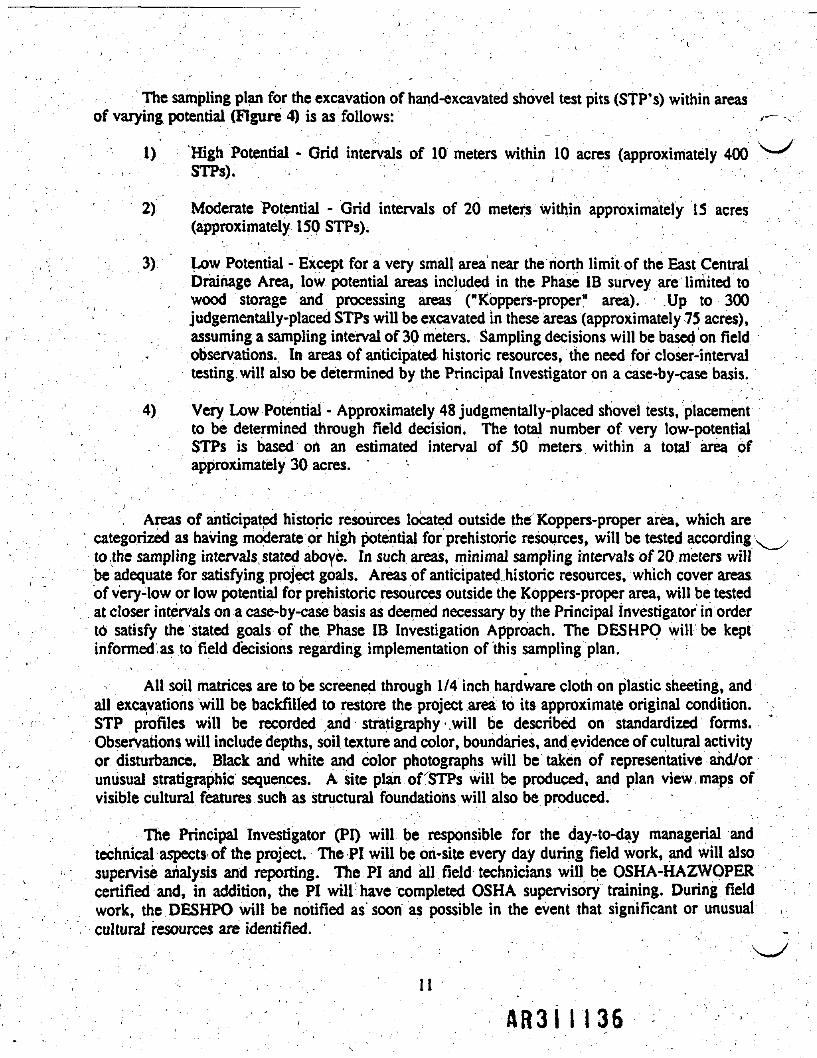
The sampling plan for the excavation of hand-excavated shovel test pits (STP's) within areasof varying potential (Figure 4) is as follows:
1) High Potential - Grid intervals of 10 meters within 10 acres (approximately 400- . - '. STPs)." '". - . - • • . : '• . , - ..".;•'• ~ ' '" . : • - ' , , '
2) Moderate Potential - Grid intervals of 20 meters within approximately 15 acres(approximately 150 STPs).
3) Low Potential - Except for a very small area near the north limit of the East CentralDrainage Area, low potential areas included in the Phase IB survey are limited towood storage and processing areas ("Koppefs-proper* area). Up to 300judgementally-placed STPs will be excavated in these areas (approximately 75 acres),assuming a sampling interval of 30 meters. Sampling decisions will be based on field
^ observations. In areas of anticipated historic resources, the need for closer-intervaltesting! will also be determined by the Principal Investigator on a case-by-case basis.
4) Very Low Potential - Approximately 48 judgmentally-placed shovel tests, placementto be determined through field decision. The total number of very low-potentialSTPs is based on an estimated interval of 50 meters within a total area ofapproximately 30 acres.
, Areas of anticipated historic resources located outside the Koppers-proper area, which arecategorized as having moderate or high potential for prehistoric resources, will be tested according ' ^to .the sampling intervals stated aboye. In such areas, minimal sampling intervals of 20 meters willbe adequate for satisfying project goals. Areas of anticipated historic resources, which cover areasof very-low or low potential for prehistoric resources outside the Koppers-proper area, will be testedat closer intervals on a case-by-case basis as deemed necessary by the Principal investigator in ordertO> satisfy the stated goals of the Phase IB Investigation Approach. The DESHPO will be keptinformed.as to field decisions regarding implementation of this sampling plan.
All soil matrices are to be screened through 1/4 inch hardware cloth on plastic sheeting, andall excavations will be backfilled to restore the project area to its approximate original condition.STP profiles will be recorded and stratigraphy will be described on standardized forms. 'Observations will include depths, soil texture and color, boundaries, and evidence of cultural activityor disturbance. Black and white and color photographs will be taken of representative and/orunusual stratigraphic sequences. A site plan of STPs will be produced, and plan view maps ofvisible cultural features such as structural foundations will also be produced.
The Principal Investigator (PI) will be responsible for the day-to-day managerial andtechnical aspects of the project. The PI will be on-site every day during field work, and will alsosupervise analysis and reporting. The PI and all field technicians will be OSHA-HAZWOPERcertified and, in addition, the PI will have completed OSHA supervisory training. During fieldwork, the DESHPO will be notified as soon as possible in the event that significant or unusualcultural resources a r e identified. . • , ' • ' „
11
AR3NI36

All work will be performed in accordance with the RI ffealth -and Safety Plan (Woodward-Clyde 1994b) for this site. It is anticipated that most intrusive activities will be performed at themodified Level D (i.e. Tyvek Suits and chemically-resistant boots and gloves).
Task 2 Data Processing and Analysis Will include processing of artifact data as per thestandard requirements of the Delaware State Historic Preservation Office. Artifacts recoveredduring the course of field investigations will be washed in the field before being transported off-sitefor inventory and analysis. Artifacts will be identified as to material, temporal orcultural/chronological association, style, and function as much as possible. Artifact analysis willseek to establish the function and extent of past occupations and the nature of the archaeologicaldeposits. This information is relevant to the potential significance of the archaeological materialsas outlined in the Management Plan for Delaware's Prehistoric Archaeological Resources (1983),the Management Plan for the Prehistoric Archaeological Resources of Delaware's Atlantic CoastalRegion (1987), and the Management Plan for Delaware's Historical Archaeological Resources(1990). Background and field data will be reviewed and synthesized to assess the potentialsignificance of any archaeological remains identified within the project area. Archaeological siteforms will be prepared for the DESHPO files for all archaeological sites identified during fieldinvestigations. Recommendations for Phase II archaeological field research to assess NationalRegister of Historic Places eligibility for any identified archaeological sites will also be developed,as appropriate.
In order to supplement .research conducted during the Phase IA study, additional limitedresearch will be completed during the Phase IB study to address specific research questions that mayprovide information useful in assessing site significance. The work will focus on investigation oforiginal maps of the project area, produced by the Army Corps of Engineers and published in thelate 19th century, which are likely held by the National Archives in Washington. Additionalbackground research will also focus on court records that may provide documentation of the "WidowColston" site, identified as being within the project area in the Phase 1A report. Research will alsofocus on identifying documentation of dikes constructed in the project area during the 19th and early20th centuries for purposes of reclaiming marsh to create pasture and hay fields.
Task 3 Report Preparation will consist of the preparation of draft and final technical reports.The technical report will contain sections on cultural history, pertinent environmental factors,methods and survey results, as well as management recommendations. . Reports will be supportedwith appropriate documentation including illustrations (line drawings) and plates (photographs), asper the reporting requirements outlined in the Guidelines for Architectural and ArchaeologicalSurveys in Delaware (1993). The report will meet the Secretary of the Interior's Standards forPreservation Planning, Identification and Archaeological Documentation which are the individualstandards found in the Secretary's Standards and Guidelines for Archaeology and HistoricPreservation (48 FR 44716) appropriate for this levelof survey. ;

3.0 PROJECT SCHEDULE
The Phase IB Survey effort is anticipated to cover a period of four months. This time periodincludes the background research and field program (Tasks 1 & 2; 8 weeks), data evaluation (Task3; 2 weeks), and report preparation and submittal to EPA (Task 4; 5 weeks). A preliminaryestimate of man hours for each of these tasks is 24,1,400, 80, and 272, respectively. The RemedialInvestigation/Feasibility Study Project schedule will be adjusted in accordance with these estimates.These schedule estimates are based on the assumption that a total of 898 shovel test pits will beexcavated and with respect to the scope of the entire Phase IB Survey effort.
Realizing that a Phase IB Survey requires an iterative approach and that the work scope maychange as information is gathered, modifications to the project schedule may be necessary.
13

4.0 REFERENCES CITED
Delaware State Historic Preservation Office1993 Guidelines for Architectural and Archaeological Surveys in Delaware. Delaware
SHPO, Dover.' ' . ' • • ' • . * ' . • ' ' " - "
Kellogg, Douglas C. ' ^ , ' . " ' • ; - '. 1995 Geoarchaeological Evaluation. Phase 1 Cultural Resources Survey for the Former
Koppers Company. Inc. Property. New Castle County. Delaware: UnpublishedReport. Submitted to Woodward-Clyde Consultants, Inc., Plymouth Meeting, PA.
Kellogg, Douglas C., Betty C. Zebooker, Donald Theime and Joseph Schuldenrein1995 Phase IA Cultural Resources Survey for the Former Koppers Company. Inc.
Property. New Castle County. Delaware. Unpublished Report. Submitted toWoodward-Clyde Consultants, Inc., Plymouth Meeting, PA. '
Woodward Clyde Consultants1994a Revised Work Plan: Remedial Investigation/Feasibility Study Former Koppers
, Company. Inc. Newport Site. Prepared on behalf of Beazer East, Inc., Pittsburghand Du PonrChemicals, Wilmington for U.S. Environmental Protection Agency,Region 3, Philadelphia.
1994b Health and Safety Plan. Remedial Investigation/Feasibility Study. Former KoppersCompany. Inc. Newport Site. Prepared on behalf of Beazer East, Inc., Pittsburghand Du Pont Chemicals, Wilmington for U.S. Environmental Protection Agency,Region 3, Philadelphia.
AR3I1139

GEOARCHAEOLOGICAL EVALUATIONPHASE I CULTURAL RESOURCES SURVEY
FORTHE FORMER KOPPERS COMPANY, INC. PROPERTY
NEWPORT, DELAWARE
For: U.S. Environmental Protection AgencyRegion III841 Chestnut BuildingPhiladelphia, PA 19107
Prepared For: Beazer East, Inc. DuPont Specialty Chemicals436 Seventh Avenue S & ER Corporate RemediationPittsburgh, PA 15219 1007 Market Street B-12224
* Wilmington, DE 19898
Prepared by: Douglas C. KelloggMAAR Associates, Inc.No. 9 Liberty Plaza
. Newark, DE 19711
Revised by: Woodward-Clyde Consultants200 Orchard Ridge DriveSuite 101
* Gaithersburg, MD 20878
REVISED April 11, 1996

GEOARCHAEOLOGICAL EVALUATIONPHASE I CULTURAL RESOURCES SURVEY
FORTHE FORMER KOPPERS COMPANY, INC. PROPERTY
NEWPORT, DELAWARE
For: U.S. Environmental Protection AgencyRegion III ,841 Chestnut BuildingPhiladelphia, PA 19107
Prepared For: Beazer East, Inc. DuPont {Specialty Chemicals436 Seventh Avenue S & ER Corporate RemediationPittsburgh, PA 15219 : 1007 Market Street B-12224
- Wilmington, DE 19898 •r-
October 2, 1995 DRAFT
Prepared by: Douglas C. KelloggMAAR Associates, Inc.No. 9 Liberty PlazaNewark, DE 19711\ • " . , . - • •
Revised by: Woodward-Clyde Consultants' 200 Orchard Ridge Drive
\Suite 101 ,Gaithersburg, MD 20878
REVISED April 11. 1996

EXECUTIVE SUMMARY ^
This companion report has been prepared to provide a basis for evaluating the presence ofsignificant cultural resources in areas that may be effected by remedial actions at the former KoppersCompany * Inc. property in Newport, Delaware. It provides refinements to the prehistoricarchaeological sensitivity model developed in the Phase IA archaeological background study (Kellogget al. 1995), "Site sensitivity11 refers to the likelihood that a given area contains material evidence ofprehistoric human activity. The refinements to the prehistoric model are based on geological datagathered during the Phase I Remedial Investigation by Woodward-Clyde Consultants. The refinementof the model is also based, on field observations of the geomorphology of the study area and aerialphotographs.
The report'also presents an archaeological site integrity model that addresses landscapedisturbance on the former Koppers Company, Inc. property. "Integrity" refers to the likelihood thatarchaeological sites in a given area are intact or undisturbed. The prehistoric site sensitivity model isthen combined with the integrity model to derive a site potential model. "Site potential" addresses theprobability for actually finding intact prehistoric archaeological sites in the study area. Areas ofanticipated historic archaeological resources were defined in the Phase IA report on the basis of historicbackground research. In this report the .areas of anticipated historic resources are compared with theresults of the prehistoric site potential model to ensure that they are adequately tested during Phase IBsurvey. >
, Geoarchaeological consideration of soil boring, aerial photographs, and topographic data allcrefined mapping of the three factors on which the original prehistoric archaeological site sensius—-/model was based. The "distance to water" factor was modified based on the identification of formerstream positions. Soil drainage characteristics were clarified somewhat for the areas south of the woodstorage area, but were only tentatively refined for the majority of the former wood storage area.
. Topographic details were clarified based on field reconnaissance after inspection of detailed contourmaps. .
. The soil boring data collected during the Phase I Remedial Investigation allowed an assessmentof disturbance in the area of the former Koppers Company, Inc. wood storage area. PA01 1 (former'wood treatment area) was almost completely disturbed, with only some small areas retaining anypossible landscape integrity. Soil borings clearly showed that the northeastern portion of the propertywas heavily disturbed and that fill was introduced over the majority of the wood storage area;However, areas of remnant plow zones arid soil horizons are present across the eastern and southeasternportions of the wood storage area. The area of the former New Castle County Sewage TreatmentFacility was also .heavily disturbed. By combining the revised prehistoric site sensitivity model with thelandscape integrity model, a prehistoric archaeological site potential model was derived. The potentialmodel takes into account the probability of prehistoric period landuse and the impacts of subsequentagricultural and industrial landuse on site survival. Based on the site potential model, the Phase IB fieldsurvey for archaeological sites can be efficiently undertaken, avoiding areas of severe disturbance andno sensitivity,
A total of 31 acres were classified as having high potential for prehistoric archaeolcresources. The high potential areas are generally located along the marsh and stream edges southseast of the former wood treatment and storage area. Areas of moderate potential totaled 45 acres in
ii

extent, and are primarily in upland areas adjacent to the former wood treatment and storage area.Finally, areas of low arid very low potential .comprise almost all of the former wood treatment andstorage area, as well as open water,and marsh land.
111

TABLE OF CONTENTS. ' . ; / ; . •
EXECUTIVE SUMMARY i
TABLE OF CONTENTS iii
LIST OF ILLUSTRATIONS iv
INTRODUCTION 1
Prehistoric Archaeological Site Sensitivity Rationale 1Anticipated Historic Archaeological Resources 3Geological Background 4
METHODS 7
RESULTS AND INTERPRETATIONS 10' . • . • /
Distance to Water 10Soil Drainage 17Topography 20Refined Prehistoric Site Sensitivity Model 23
- . " ! 'LANDSCAPE INTEGRITY OF THE FORMER KOPPERS COMPANY, INC.PROPERTY 28
Prehistoric Archaeological Site Potential 33
SUMMARY AND CONCLUSIONS 35
REFERENCES CITED 36
APPENDICES 40
Appendix I: Summary Interpretations of Soil Borings 40Appendix II: A Refined Location for Former Koppers Company, Inc.
Office Building 46
111
A83MUI*

"VJ " ^ .•. •- - •' ,.- •••:'. -. : - ... - .-, . '- • • - .. .:. .- • '- FIGURES PAGE
1 The Former Koppers Company, Inc. Property 2
2 Regional Drainage Patterns of the Study Region 6
3 Geomorphological Interpretations •: 11
4 , "Distance,to Water" Factor , . 12
5 Construction Plans for Delaware Power and Light CompanyTransmission Line Across the Former Koppers Property 14
6 Aerial Photographic Interpretations of Soil Drainage Characteistics 19
7 Soil Boring Interpretations of Soil Drainage Characteristics 21
' 8, Areas of Remnant Upland Topography , '22" • • ~ • '." " ~ ' '- . f . ~9 Overlay Map of Prehistoric Site Sensitivity Factors - 24
10 . ' Revised Prehistoric Site Sensitivity Model 26
II Profile & Plan of the Central Portion of FormerKoppers Company, Inc. Property ~ . 29
Soil Boring Interpretations of Disturbance . 30
Prehistoric Archaeological Site Potential Model & Areas ofAnticipated Historic Resources ' i" 32
14 -. . Refined Location for the Former Koppers Company, Inc. Office Building 47i . . . ' • ' " • ' ' • ' .TABLES
1 . Soil Borings Reviewed and Monitored 7
2 Aerial Photography Examined 9* . •' : ' • • • '; ' ' " • • •. ; *\ . ' : . • • " . , .
3 Explanation of Scoring for Former Koppers Company, Inc.Prehistoric Site Sensitivity Map : 27
f-'-1 4 Prehistoric Site Potential 34
-.' • .- ' V ' • - ' • •' - • • ' '. • • -'iv . ' . ' : --"" -. .- •'•."--' • / \

INTRODUCTION
This document provides refinements to the prehistoric archaeological sensitivity modeldeveloped for the former Koppers Company, Inc., Newport, Delaware property1 (Figure 1) ina Phase IA background study (Kellogg et al. 1995). The refinements are based largely ongeological data gathered during the Phase I Remedial Investigation by Woodward-ClydeConsultants (WCC) (Woodward-Clyde 1994b). The major source of data is soil borings takenas part of Phase I of the Remedial Investigation (RI). Interpretations are also based on fieldobservations of the geomorphology of the study area and aerial .photographs. The use of thisinformation in landuse studies is also discussed. This document is a companion to the Phase IAarchaeological report (Kellogg et al. 1995).
This report also addresses the issue of archaeological site integrity (that is, the potentialfor undisturbed archaeological contexts and deposits) on the former Koppers Company, Inc.property. Both the potential impacts of natural geological processes and agricultural andindustrial land use on the archaeological record were considered.
The refined prehistoric archaeological site sensitivity model was combined with the. integrity model to derive a prehistoric site potential model. The site potential model addressesthe probability for actually finding intact prehistoric archaeological sites in the study area basedon the. likelihood of prehistoric occupation and the probability of site preservation into thepresent-day. Thus, Phase IB field survey for archaeological sites can be efficiently undertaken,avoiding areas of severe disturbance and no sensitivity.
Prehistoric Archaeological Site Sensitivity Rationale
In the Phase IA report (Kellogg et al. 1995:3-12 - 3-15), a sensitivity map for prehistoricarchaeological sites was prepared based on three factors:
• Distance to marsh edge• Soil drainage characteristics• Topography .
Areas within 100 m (330 ft) of the marsh edge were considered Highly sensitive basedon previously developed predictive models for the Delaware coastal plain (see Custer andBachman 1986a:131-132; Kellogg 1993:60-71), Areas more than 100 m (330 ft) from themarsh edge were considered Medium sensitivity. Areas greater than 200 m (656 ft) from themarsh edge were considered Low sensitivity. The better-drained Aldino-Keyport-Mattapex-Urban soil complex was considered sensitive, while the poorly-drained Othello-Fallsington-Urbansoils were considered low in sensitivity for prehistoric archaeological sites. Topographic highs,low knolls or ridges were also considered sensitive areas, A scoring system was developed
'In this report, the "former Koppers Company, Inc. site" is referred to as a "property" to avoid confusion arising fromdifferent definitions of the term "site." The use of the term "site" in this report is reserved for the designation anddiscussion of prehistoric or historic human habitations and material evidence of human use and occupation of portions of theproperty within an archaeological context.
i AR3I I 1-1*6"

FORMERKOPPERS COMPANY, INC. SITE,
NEWPORT, DELAWARETHE FORMER KOPPERS
COMPANY, INC PROPERTY I -
AR3tl»f».7

for assigning sensitivity values to subareas of the former Koppers Company, Inc. property(Kellogg et al. 1995; Table 2).
-.- Herein, the mapping of the three factors discussed above is refined based on newinformation. In the Phase IA report (Kellogg et ah 1995), the "distance to marsh" factor, wasconsidered as a proxy for "distance to water" (e.g., stream). The assumption was that the marshedge represented potential former stream boundaries. Preliminary field reconnaissance suggested
/that closer examination of the landscape and aerial photograph interpretation could be used tobetter establish formed stream courses and meanders.
The soil borings conducted during the RI investigation were used as a source of soilsdata, as well as potential landscape (geomorphological data), and also as a means for evaluatinglandscape and soil disturbance. Aerial photograph interpretation, coupled with fieldreconnaissance, was also considered a means for refining soil mapping of the study area, as theSoil Conservation Service maps (Matthews and Lavoie 1970) generalized and grouped the soils.Finally, closer examination of large-scale topographic maps and field examination of topographicfeatures was expected to allow refinement of the topographic factor of the prehistoric sitesensitivity map.
Anticipated Historic Archaeological Resources
The same factors used in the prehistoric site sensitivity model can be used in discussinghistoric landuse patterns. However, for this relatively small project area of approximately 240acres, the documentary background research completed during the Phase IA study providesreliable indications of probable historic archaeological site locations. For this reason a historicsite sensitivity model was not created as part of this geoarchaeological evaluation. Instead,results of Phase IA historic background research have been used to determine general areas ofanticipated historic archaeological resources.
The factors considered as pertinent to the landuse decisions of the early historic settlersof the former Koppers Company, Inc. property area include: 1) proximity to navigablewaterways, 2) availability of easily obtained potable water, 3) well-drained and fertile land forboth occupation and agricultural pursuits, and 4) access to land transportation arteries (first roadsand then railroads). In addition to these geological and geographical factors, there are otherconsiderations that may also be pertinent to identifying historic period landuse patterns. Settlers'cultural backgrounds also played a role in settlement decisions. European landuse patterns werebased upon such major factors as proximity to markets, presence of good millseats, access routesto population centers, level land, prevailing winds, etc. The influence of these factors onhistoric landuse patterns in the project area will be evaluated in the Phase IB technical report.
A83I

•\J
The project area is situated in one of the most complex geological settings of Delaware.The former Koppers Company, Inc. property is on the feather edge of the Coastal Plain justsouth of the Piedmont fall line. The study area is also; at the confluence of two of the largeststreams in northern Delaware. Both steams are tidal along the southern and western boundariesof the study area, and the head of tide in White Clay Creek is just to the west (unpublished dataprovided by Steven Abott, USGS, Dover). -Thus, the study area lies at the boundary betweentwo geologic and geomorphic provinces and in an area of active stream and marsh evolutiondriven by sea-level fluctuations. To further complicate the geology, sea-level stood above itspresent level during the last interglacial period circa 120,000 years ago (Cronin et al, 1981;Rtggs and Belknap 1988:152). Sea level was approximately six meters (20 ft) higher, so thatthe Christina River and White Clay Creek basins would have been completely submerged fromthe Delaware River shore to well beyond the Churchmans Marsh vicinity. Much of the studyarea would have been submerged, and the surface of the land was reworked as sea-level roseand fell. During the Late Pleistocene and early Holocene, sea level stood as much as 30 feetbelow its present elevation. The general geological contekt and background of the Study areais also given in the Revised Phase I Remedial Investigation Work Plan (Woodward-ClydeI994a), and in the Phase IA archaeological report (Kellogg et al. 1995).
Characteristics of the geological context of the former Koppers Company, Inc. propertythat are important to archaeological assessment of settlement patterns and site preservationpotential are discussed in more detail herein. The major geological factor determining the
; present geomorphology is the orientation and variability of Pleistocene deposits of the ColumbiaFormation. The Columbia Formation influenced:
1) the courses of subsequent streams; and .
2) variability iri surface topography and soils.
The Columbia Formation consists of gravel bars and channel fills with intervening areasof finer-grained sediments oriented roughly northeast to southwest. The Columbia Formationwas deposited subaerially as alluvial fans by the ancestral.Delaware River, probably fromdischarge of glacial meltwater heavily laden with sediments eroded from areas to the north(Jordan 1964; Jordan and Talley 1976; Spoljaric 1967,1972,1982; Scott Andres and KelvinRamsey, Delaware Geological Survey, personal communication). Thus, local drainage iscontrolled by both the contact between the Piedmont and Coastal Plain at the fall line and alsoby the orientation of surficial deposits. /
There are only thin, limited sediments of late Pleistocene anid Holocene age overlying theColumbia Formation. The surface expression of the Columbia Formation is moderated by a thinmantle of "wind-blown silt (loess) deposited over the entire region (Carey et al. 1976? Foss etal. 1978; Rebertus et al. 1989; Simonson 1982), resulting in a mosaic of topographic and soilcontexts. Some Holocene alluvial fan deposits are known from the fall line zone in Delaware,but these are limited in extent and not mapped in detail (Spoljaric 1972:21-24; Stott Andresand Kelvin Ramsey, Delaware Geological Survey, personal communication). As discussedin the Phase IA report (Kellogg et aL 1995), prehistoric inhabitants of the region used andsettled most frequently on higher and drier landscape elements. ,
4 AR3I I |I*9

Stream patterns also influenced prehistoric settlement. Larger streams providedtransportation routes and access to riverine resources. During the Holocene, tidal influencesassociated with sea-level rise led to the development of biologically-productive marshes in theChristina River and White Clay Creek (Custer 1982). In addition, the lower reaches of thesetwo streams lie within broad, active meander belts (Figure 2) developed during the latePleistocene. Thus, relationships between any particular locality and the rivers have changedover time. The desirability of a place for occupation would be affected, as well as the potentialfor fluvial deposition that might bury or erode archaeological deposits.

MA1 PROJECT: D-41FORMER
KOPPERS COMPANY. ING SITE.NEWPORT. DELAWARE
FIGURE 2 ,
REGIONAL DRAINAGE PATTERNSOF THE STUDY REGIONAR3

METHODS
A network of soil borings (Figure 1) was established across the former KoppersCompany, Inc. property to gather geological and hydrological data on which to base aConceptual Site Model (CSM) and obtain soil samples for analytical testing (Woodward-Clyde1994b). For the purposes of the archaeological modeling, a number of soil borings weremonitored in the field (Table 1; Figure 1). In addition, the field logs for many of the other soilborings were reviewed (Table 1). Transcripts based on the original field notes were reviewedfor the remainder of the soil borings (Table 1). Details of the soil borings that were notobserved were discussed with the Woodward-Clyde field geologists who supervised and loggedthe borings. Sediment recovery in thirteen soil borings was observed. The direct fieldobservations, along with discussions with the field geologists, provided a basis for interpretingthe soil borings not observed by the author.
TABLE 1: Soil Borings Reviewed and Monitored
Field Originals TranscriptsMonitored Reviewed Reviewed
216 104 203 102401 106 204 103402 , 107 205 112403 108 209 113 .603 109 210 116609 110 211 120610 111 212 122615 * ", 115 213 206616 • 117 214 207617 118 215 208618 124 303 217619 125 306 605620 126 601 606
127 602128 604 • .. ,201 607
. ' v. 202 . • ' -,••••• '.'' .••Originals » Original field notes recorded in the field by Woodward-Clyde geologists.
Transcripts = Abbreviated summaries of field notes entered onto standardized forms.
1—"—————:——————————'————: ' >

Soil borings (SB) numbered 100 through 200 were taken within the operational areas (i.e.the former wood treatment and wood storage areas) of the former Koppers wood treatmentfacility. Soil borings numbered 300 through 600 were taken from surrounding areas. The forty-four soil borings from the operational areas provide a potential glimpse of the pre-industrial ?setting of the portion of the former Koppers Company, Inc. property used as a Wood treatmentfacility. Geological logs for thirty-eight (Table 1) borings in the operational areas werereviewed, and one soil boring was observed.. Examples of interpretations are discussed below,and summary interpretations of the soil borings are included as Appendix 1. Completedescriptions of the soil borings will be provided in the RI report (in preparation) by WCC.', -
-Aerial photographs (Table 2) were examined for evidence of soil moisture contrasts andevidence of abandoned stream channels and other geomorphological features. Maps andhistorical documentation were included when available to clarify and refine interpretations. Soiland geological interpretations were discussed with representatives of the Soil ConservationService and the Delaware Geological Survey, and other information was provided by the NewCastle County Department of Public Works, Delmarva Power and Light Company, and the U.S.Geological Survey (USGS).
1 • • - - -. ' ' _ - • ' ' ' • • ' ' . . • ' • , . ' , -' ,'
Geomorphological interpretations are based on geological principles of sedimentation,erosion, and stream flow (e.g., Bowen 1985; Butzer 1971:157-239; Krumbein and Sloss 1963;Reineck and Singh 1980; Schumm 1972). In general, sediment size and sorting are directlyrelated to water velocity in fluvial systems. Fining upward stratigraphic sequences indicatedecreasing flow velocity, while coarsening upward sequences indicate increasing flow velocity.Steep slopes on the landscape and abrupt changes in sediment stratigraphy indicate erosion orchanges in flow regimes and/or depositiona! environments. •
A R 3 I I 153

TABLE 2: Aerial Photography Examined !-"\—''
Date Scale Comments, , .
1937 1:20,000 Black and White; two exposures
1937/ Oblique Black and White; Four exposures show the'1938 , . wood treatment facility from four angles
1948 . 1:24,000 Black and W|iit$; two exposures
1961 1:20,000 Black and White; two exposures
1962, 1:20,000 Black and White; I exposure enlarged to , Y1 approximately 1:8000 '
1968* 1:200 Enlarged acetate copy of Blackand White exposure
1973 1:30,000 Black and White; two exposures ,-. • '*","'• " ' *1982 1:2000 Color Infrared; one exposure enlarged to
. approximately 1:80001983 1:32,500 Color Infrared; two exposures
1988 1:40,000 / Color Infrared; two exposures
1989 1:660 Black and White; one exposure, enlarged
* A blue print copy of the relevant portion of this photograph was obtained from the New CastleCounty Planning Department.

RESULTS AND INTERPRETATIONS
Distance to Water ,
.Aerial photographs were analyzed for evidence of abandoned meanders and formerchannels of Hershey 'Run (Red Clay Creek2), White Clay Creek, and the Christina River. Froma regional perspective, there is clear evidence of active stream channel migration. The base ofChurchmans Mafsh was probably established through migration of either White Clay Creek orthe'Christina River over the area either ometimein the Holocene, and/or during an earlier highsea-level stand (e.g.; the last interglacial 120,000 years 6.P.3 when sea level stood circa sixmeters above its present level). There is also an abandoned channel of the Christina River southof its present channel on the south side of Interstate 95. Downstream of the former KoppersCompany, Inc. property, typical meander bends of a sluggish coastal plain stream were presentin the Christina River before Interstate 95 was constructed (Figure 2).
More subtle features are present along the southern nd western margins of the formerKoppers Company, Inc. property.(Figure3). Aerial photograph interpretation identified severalpotential abandoned river channels on the former Koppers Company, Inc. property (Figure 3,Features 7 and 8). One possible channel was observed in a brief field reconnaissance undertakenfor the Phase IA study (Kellogg et al. 1995), and has been verified herein. Additional channelswere also observed in field reconnaissance undertaken for this report and later verified throughaerial photograph inspection. Channels were identified by surface expression and form.Channel margins were identified by abrupt changes in slope representing stream-cut banks.Also, possible buried channels were identified in some soil borings.
The most significant conclusion drawn from the analysis of former stream channels is thatthe Christina River has migrated south from a position skirting the southern end of "the Boot* -a peninsula of land that separates the West Central and East Central Drainage Areas (Figure 1).The former channel edge is marked by small islands in the marsh of the East Central DrainageArea (Feature 1 on Figure 3). The funnel-shaped marsh occupying the north half of the EastCentral Drainage Area has probably not been occupied by former channels of the ChristinaRiver; thus, the distance to water factor is revised for the southeastern portion of the formerKoppers Company, Inc. property (Figure 4). There may, however, be a meander scar at theeast side of "the Boot" where a steep slope abuts the marsh. " -• / . - \ . . . . . • • ' . . - . " • • ' • ' ' • - - • ' " "
The, small drainage in the area of the funnel-shaped marsh of the East Central DrainageArea (Figure 3 - Feature 2) does not support a perennial stream, and is thus not considered apotential water source/transportation corridor of the same character as Red Clay Creek, WhiteClay Creek, and the Christina River. Also, the close proximity of larger and more reliablestreams decreases the potential influence of this minor drainage feature onprehistoric settlement.
2 Hershey Run occupies an abandoned channel of Red Clay Creek. Al some time in the past. Red Clay Creekmeandered around the north end of Bread and Cheese Island and down the channel how occupied by Hershey Run. . .
3 B.P. » before present. ^ . ' ' - ' _ .
, 10 ;Aft3l H55

SCALE
MAI PROJECT: D-41FORMER
KOPPERS COMPANY. INC. SITE,NEWPORT. DELAWARE
GEOMORPHOLOGICALINTERPRETATIONS
ftR3

100 METERS
200 METERS
MAI PROJECT: D-41 FIGURE 4
'DISTANCE TO WATER" FACTOR
157

Therefore, the stream was not considered in revising the 100 m distance to water sensitivityfactor. The 100 - 200 m distance to water medium sensitivity zone was modified, however, /because the history of the drainage is uncertain and the uplands surrounding ihe upper end of ; sthe drainage may have been attractive to prehistoric settlement if fresh water was available. Theconfluence of the possible drowned drainage and the Christina River would also have provideda setting for prehistoric settlement; thus, the islands marking the former channel (Figure 3 -'Feature 1) of the Christina River may be considered Highly sensitive for prehistoric occupation. '
The East Central Area marsh is fringed along the Christina River and the old channel ofthe White Clay Creek by levees that rise over two meters above the marsh. In addition, theCentral Drainage area is fringed along both the Christina River and White Clay Creek by theselevees (Figure 3 - Feature 3). These may be artificial dikes that allowed the marsh to beexploited for pasture or hay. No conclusive evidence for dikes could be located, althoughhistorical documentation may exist. Churchmans Marsh is known to have been diked from the :mid-1800s until the 1930s (Brooks 1957:4-5). It is likely that the levees along the East Centraland Central Drainage Areas of the former Koppers Company, Inc. property are not natural,over-bank flood deposits. »
. The geological development of the West Central Drainage Area is more complex thanthe East Central Drainage Area. An abandoned channel extends south from the west end of "theBoot1* towards the confluence of Hershey Run with the Christina River (Figure 3 - Feature 4).A present-day island is a remnant of the channel margin that shows on earlier maps and aerialphotographs. The north end of the channel ends rather abruptly at "the Boot." In an effort toascertain if the channel turned directly west or was perhaps filled to provide a base for a -powerline tower, construction plans were consulted (Frank Sobonya, Delmarva Power and \Light Company, personal communication). The plans (excerpt shown in Figure 5) do not callfor fill or pilings as a foundation for the tower, therefore, it is concluded that a channel flowingfrom the west had been deflected to the south by the Pleistocene gravels that compose "theBoot." Soil boring SB609 at the south end of the Boot was placed in an unimproved road andclearing under the powerline. Gravel is exposed in the surface of the road, and the soil boringencountered coarse sand and gravel continuously to a depth of over 60 feet.
There is further evidence of former channels along the southern margin of the WestCentral Drainage Area in the form of a low, natural levee parallel to the active natural levee ofthe river (Figure 3 - Feature 5). Furthermore, there are a series of deep gullies occupied byeither standing water or marsh cut into the upland edge at the southwest corner of the WestCentral-Drainage Area (Figure 1 - Feature 6). Several soil borings were added to the samplingprogram after Terrain Conductivity surveys (Woodward-Clyde 1994) aimed at locatinganomalies were conducted. Soil borings SB615, SB616, SB617, and SB620 were placed in andnear linear depressions in the southwest area of the study area (Figures i and 3). Demolitiondebris in the form of treated lumber, railroad ties, corrugated metal, and twentieth century glassand other'debris had been dumped in the depressions, the soil borings demonstrated that thelinear depressions are segments of an abandoned channel (Figure 3 - Feature 7). The channel can be traced northwest to Hershey Run. Segments of the abandoned channel have beendelineated as wetlands on maps developed by WCC during the Phase I RL
The abandoned channel curves to the southeast from the location of Potentially Disturbed vAreas (PDA) D, E, G, and F (see Figure I for the locations of the PDAs). South of the j
l3 AR3UI58

SOURCE: DELAWARE POWER & LIGHT COMPANY. PLAN *2. REBUILD 6804 UNE.MUNE 11. 1965
800
250
SCALE
MAI PROJECT: D-41FORMER KOPPERS COMPANY, INC. SITE,NEWPORT. DELAWARE
FKJURE 5CONSTRUCTION PLANS FOR DP&L TRANSMISSIONLINE ACROSS THE FORMER KOPPERS PROPERTY
13 AR3I I 159

powerline access road, the channel is filled with water. The powerline access road crosses theabandoned channel on gravel fill. An alternate route for the channel's connection with WhiteClay Creek may lie to the west where the present natural levee, of White Clay Creek dams asmall drainage that leads north into PDA F. The abandoned channel crosses PDA D, E, andF and passes to the east of PDA G and C. The northern half of the abandoned channel iscompletely buried, but the mouth of the channel is clear as a gap in gravel deposits exposed inthe bank of Hershey Run. The mouth of the abandoned channel is also marshy and drainsuplands to the south and east, The area of PDA G is higher ground clearly lying on the westof the abandoned channel. Soil borings taken in PDA D, E, F, and G confirm the presence ofthe channel. For example, SB615 in PDA D was placed in the center of the linear depressionand did not encounter any Columbia Formation sedimerits overlying the Potomac Formation.The channel had cut completely through the Columbia Formation, f --• < •>• . • ' .' '• - -
The channel is judged to predate human occupation of the region (circa 12,000 yearsB.P.), because the northern half has been Completely filled. It is unusual that the center of thechannel is filled rather than the ends. Normally, an abandoned channel fills gradually with 'alluvium during floods when sediment-laden water fills the former channel (e.g., Happ et al.1940). Sediments build up more rapidly at the ends of the channel where stream flow energiesrapidly decrease, giving way to quiet water deposition inside the abandoned channel. Thus, anabandoned channel is usually manifested as a linear wetland or depression that is deepest at itscenter. The abandoned channel identified on the former Koppers Company, Inc. property isfilled in the center and is deeper at the ends, which suggests filling by subaerial or otherprocesses, such as drowning in a nearshore marine setting. The channel was filled either duringa higher stand of sea level more than 100,000 years ago, or by colluvial or aeolian processesduring the terminal Pleistocene. .Alluvial fan deposits of Piedmont streams have been mappedby Spoljaric (1972; see his Figure 6) west of the study area. Spoljaric tentatively dates thealluvial fans to Late Pleistocene glacial times (Spoljaric 1972:21-24) prior to human occupationof the region. Soils underlying loess deposits have been dated by Foss et al. (1978) to 10,520radiocarbon years B.P. The abandoned channel most likely predates 10,000 B.P. and wasprobably occupied by Red Clay Creek sometime during the late glacial maximum when theclimateof the region was substantially wetter than the present (Kellogg and Custer 1994:12-21),Even if the channel dates as late as 10,000 years B.P., the impact on prehistoric habitation ofthe former Koppers Company, Inc. property would be minimal. If human occupation of theregion dates at the earliest to 12,000 years B.P,, then the channel would have been a potentialfactor in human settlement for only l/6th of that time (12,000-10,000/12,000 = 1/6). The"distance to water* factor was, therefore* not modified to reflect the presence of this ancientchannel of Red Clay Creek*. Furthermore, the margins of the channel do fall within the areaof Medium site sensitivity (between 100 and 200 m from water), because it is less than 200 mfrom White Clay Creek and the marsh fringing Hershey Run on the west (see Figure 4), andthe north and south ends of the channel are within 100 m of active streams.
V ' . . . ' • ' " - ' • • . ' • ' .
Aif older possible channel may be present underlying the west half of the study area,extending frpm the northern end of the West Central Drainage Area to Hershey Run (Figure 3- Feature 8). Organic-rich sediments were encountered at depth in SB601, There is no surfaceexpression to this possible channel. This and other more deeply buried channels that may be
Sec Footnote Number 2.
15

present to the east are substantially older than prehistoric hujnan occupation of the region. RedClay Creek (Hershey Run) has apparently migrated west during the last several hundredthousand years, perhaps pushed by interglacial sea-level stands that repeatedly brought tidalinfluence into the ancestral Red Clay Creek and the Christina River region. The "Boot" jsapparently a Columbia Formation gravel bar that may trend to the northeast, forming .the' westmargin of the East Central Drainage Area. Soil borings in PAOI 4 may have penetratedColumbia Formation channel fill associated with the gravel bar, and the East and West CentralDrainage areas probably inherited their forms from an underlying braided channel system ofwhich the gravel bar that forms "the Boot" is a component.
, The West Central Drainage Area itself was probably modified by meanders of theancestral Red Clay Creek (Figure 3 - Feature 9). The margins of the marsh are concave arcsbordered by steep slopes or scarps in several places. Three meander scars may be present asindicated on Figure 3. The ages of these former channel positions cannot be determined withoutchronological control (e.g., radiocarbon dating). The channels would have been smaller thanvthe present tidal channel of Red Clay Creek, and therefore probably pre-date tidal influence herewhich reached to the confluence of White Clay Creek and the Christina River sometime after3000 years B.P. (based on Belknap and Kraft 1977). Thus, the channels are judged to berecent enough to have influenced prehistoric, use and occupation of the study area. It was notnecessary to revise the "distance to water" factor for the West Central Drainage because it wasoriginally based on the marsh edge (Figure 4). The marsh edge was, and is, an adequateapproximation of former stream positions.
Soil Boring SB6 19 was placed near the north end of the worker's housing area (PDA C)on the western edge of the study area adjacent to marsh fringing Hershey Run (Figure 3 -Feature 10). The boring encountered a thin, A soil horizon over coarse sand and graveldeposits. A six-inch thick lens of well-sorted, white sand was encountered at 3.5 ft. Coarsesand and gravel continued below, and water was encountered at 4.5 ft. The upper portions ofthe Sequence suggest alluvial over-bank deposition. The lower deposits are probably Pleistocenein age, but the upper sediments could be relatively recent. Hershey Run most likely passeddirectly east of this location at some time in the Holocene and later meandered to the west.There is a possibility of Holocene alluvial deposition here, and also, to a lesser extent, to thenorth where Hershey Run is directly adjacent to the upland end of the former Koppers Company,Inc. property and north past the "Fire Pond." Soil Boring SB303, taken south of the Fire Pond,encountered a thin layer of fill over eight feet of silty sand with some layering. Thus, the onlyarea of potential Holocene alluvial deposition on the former Koppers Company, Inc. propertyis a narrow strip along the western edge adjacent to Hershey Run and its fringing marsh (Figure3 - Feature 10). There is little evidence of recent alluvial deposition along Red Clay Creek itself(except the natural levees discussed previously). •
, In summary, evidence of former stream channels is present in the study area. Channelsare apparently younger to the east across the study area, and ancient channels are deeply buried.Marsh is slowly encroaching on the north end of the East Central Drainage Area, but thesouthern half of the marsh has accumulated as the Christina River migrated south in geologicallyrecent times. The West Central Drainage Area was probably sculpted by stream meandersbefore tidal influences reached this area in the late Holocene. An abandoned channel that can
' '
AR3I I 161

be traced northwest across the west end of the study area most likely pre-dates human occupation / ^of t h e region. , , v >
Verification and dating of the abandoned channels and meander scars tentatively identifiedthrough aerial photograph interpretation and field reconnaissance would have to be based ontransects of cores as specified in the Ri Work Plan (Appendix to Woodward-Clyde 1994a).The marsh coring proposed as part of the original Phase IB plan was intended to establish, thepotential for prehistoric archaeological sites .buried below marsh peats. That potential isconsidered low here for two reasons:
I) The low-lying areas that are being drowned by encroaching marsh are based onpoorly-drained soils that extend onto adjacent upland soils as discussed later; and, ' . • • . ~ • - - ' . i • • ' • • " -
• r • ' • - ' - . . ' • . • - • - . ' • - . ' - ' . ' - . . "2) Meander scars and former channels would have destroyed or precluded
archaeological deposits elsewhere in the marshes.
For the purposes of Phase IB archaeological reconnaissance and survey, it is notnecessary to ascertain the age of the former channels and meander scars identified here.However, landscape and environmental reconstructions may be necessary as part of mitigationefforts for archaeological sites considered eligible for nomination to the National Register ofHistoric Places. It is recommended that marsh coring to establish the environmental context ofprehistoric archaeological sites be delayed until Phase 11 archaeological investigations, if deemednecessary, are carried out. . . - . > •
Soil Drainage
The study area was classified by the U.S. Soil Conservation Service as Othello-Fallsington-Urban, poorly-drained, nearly level soils, contrasting with areas of Aldino-Keyport-Mattapex-Urban, moderately well-drained, level to nearly level soils (Matthews and Lavpie1970). The majority of the study area, including almost all of the operational areas, wasmapped as belonging to the Othello-Fallsington-Urban complex with no attempt to delineate the ,members of the complex. Likewise, only one large irregular area surroundingahe West CentralDrainage Area was mapped as relatively well-drained. . Preliminary inspection of aerialphotographs suggested that finer resolution could be obtained for the study area. The soilborings also provided a basis for soil classification. The goal of the soil mapping undertakenhere was to establish contrasts between areas of moderate to well-drained soils and areas ofpoorly-drained soils5. .
The earliest aerial photography available, dates to 1937 when the wood treatment facilitywas already in place. At the time, the two farms present on the southern half of the former
* The contrast intended herein is between poorly-drained soils that can remain saturated for extended periods of lime andare thus uninhabitable, and all other soil drainage classes. The phrase "well-drained" should be read as "not poorly-drained" and refers to habitable soils. This usage does not. and is not intended to, correspond to U.S. Soil ConservationService definitions of soil drainage for agricultural purposes.• - - - ' •
AR 3 1 116-2;

' . . • • ' • • ' " - • : , •Koppers Company, Inc. property were still iri operation and virtually the entire area was cleared.Differences in soil moisture are discernable in the plowed areas south and west of the woodtreatment facility. Wetter soils appear darker, while drier soils appeaif; lighter. This generalinterpretation was confirmed through consultation with the Soil Conservation Service (Mary AnnLevane, personal communication). The same differences are present on photographs taken in1048, 1962, 1968, and subsequent images. Consistent interpretations of the soils are mappedon Figure 6. Areas of intermediate drainage could be identified on the aerial photographs also.These areas are designated as "somewhat poorly-drained" on Figure 6, because drainagecharacteristics cannot be clearly defined based on existing information, but this informationsuggests that they are not well-drained. Conservative interpretations of soil drainagecharacteristics were applied when determining prehistoric site sensitivity (Rgure 9), Areas wereconsidered "poorly drained" only if soil boring data confirmed poorly drained or somewhatpoorly drained soils (Figure 7). Areas defined as "somewhat poorly drained" only on the basisof aerial photographs (Figure 6) were not assumed to be "poorly drained" when determining sitesensitivity. More detailed resolution of soil drainage characteristics is not possible until Phase IB survey data, or additional soil boring data are available. ,
;Most of the, somewhat poorly-drained soils fell within the area of the former rajl yardwhere the original landscape has been altered (Figure 6). The original drainage characteristicsof these areas are not known, but drainage is clearly inhibited in these areas at present. Areasof poorly-drained soils are also associated with low-lying areas near the marshes of the East andWest Central Drainages. In particular, small tributary drainages that lead into the uplandssurrounding the marsh are based on poorly-drained sediments. The fact that the wet soils arevisible on aerial photographs well up onto higher ground suggests that the drainagecharacteristics of these areas are due to parent material, and not due to progressive sea-levelinundation. • • - : . . . - "
; in general, the original SCS interpretation of a poorly-drained Othello-Fallsington-Orbancomplex contrasted with an Aldino-Keyport-Mattapex-Urban complex is supported; however,better resolution is possible in distinguishing soil drainage. No attempt was made to assign soilsobserved to named units or associations. The results allow refining of the prehistoric, sitesensitivity model in that poorly-drained areas within the moderately-drained Aldino-Keyport-Mattapex-Urban complex can be down-graded in sensitivity. On the other hand, better-drainedareas could be distinguished within the poorly-drained Othello-Fallsirigton-Urban complex.These areas .are upgraded in terms of prehistoric site sensitivity.
Soil drainage in the area of the wood treatment facility and wood storage area is almostcompletely obscured on aerial photographs. However, consistent features are present on aerialphotographs that were taken after the facility was removed. False, color infrared photographsclearly show dark areas (water absorbs infrared wavelengths) that suggest standing water.Standing water was observed in these areas during field reconnaissance, and the Woodward-Clyde preliminary wetlands map corroborates these observations.
• - •' "' s ' '-- •• ; - - ' \, •• ' '.•'.'' '•''•.-''The soil borings taken in the operational areas provide an independent means of assessing
soil drainage in the wood storage area. Poorly-drained soils and parent material were identified. . ' . . • , ;...; •• • - " ; • ' • : ' • ; ' ; ; ; • - . ' - - . ; • - - , . ' . ' • • " . - . •;:.,... ,v-.' :• '" '. . • ', . ....,. -; '';.-' '. X' .'is', / '•' . .,"• ; \ • ; .. -. ' " . . . "•
AR3I1163

- " - , ' " ; . ' • " " ' ' " - • ' - ' ' ' ^
0 " HKRT • I10»
0 MUTLMS 4UQ
''-''• ' . SCALE '• •
MAI PROJECT: D^lFORMERKOPPERS COMPANY, INC. SITE,
NEWPORT, DELAWARE
- X
FIGURE 6 /AERIAL PHOTOGRAPHICINTERPRETATIONS OF SOIL
DRAINAGE CHARACTERISTICSAR3I 1161*

based on the presence of gleyed horizons and iron-staining and concretions, indicating a highwater table. Clay sediments near the surface also suggested poorly-drained parent material andthe potential for impede*! drainage. For example, SB209 and SB210 encountered organic-richsilts, gleyed sediments, and iron-staining characteristic of poor-drainage., Soil borings to thewest did not exhibit these characteristics. As shown on Figure 7, soil borings in the areassurrounding the operational areas encountered well-drained soils or sediments. Within theoperational areas, a large portion of the eastern half could be delineated as poorly-drained basedon the presence of clays near the surface and ground water staining of parent material and B soilhorizons. Two other poorly-drained areas were identified in the western half of the woodstorage area. A linear area in the northwestern quadrant of the wood treatment area appears tobe associated with a surface drainage leading to the northeast. The other poorly-drained areaheld standing water when observed during field reconnaissance in early 1995.
PAOI 4 comprises the "South Ponds" and immediately surrounding terrain (Figure 1).Soil borings in this area encountered relatively intact soil profiles. A clear plow zone overclayey subsoil was encountered in SB403. Soil boring SB401 .was placed near a stream channeland encountered a silt loam soil sequence that grades into sand and gravel. Soil boring SB402encountered iron-stained and gleyed6 sediments, indicating a high water table. PAOI 4 isgenerally low-lying and poorly-drained. An artificial earthen dam runs east-west across thesouth end of the area. Soil Boring SB608 was placed south of the dam to the west of the naturaldrainage. Soil Boring SB407 was to the west of SB608 on the same ridge. A borrow pit ispresent in the ridge south of SB407, and marsh lies to the south beyond the ridge. The SouthPond Area is not considered a sensitive area for archaeological resources; however, the well-drained ridge to the south (see Figure 6) is sensitive.i • * . : *. • ' , . *
The aerial photograph and soil boring interpretations generally concur. In comparisonwith the U.S. Soil Conservation Service mapping (Matthews and Lavoie 1970), the soil mosaicis more complex and a large portion of the area mapped as the poorly-drained Othello-,F£llsington-Urban complex may be relatively well-drained. The soil drainage factor as appliedto the prehistoric archaeological sensitivity model was treated conservatively, in that if an areawas not clearly identified as poorly-drained, then it was assumed to be relatively well-drained.
Topography' ' "' , . . - ; ' ' •" / ' ' ' .' ' 5 f '
Analysis of the topography of the study areas was refined through examination of detailedcontour maps (1 foot contours at a scale of 1 inch = 100 feet) and field reconnaissance (Figure8). The area of the former Koppers Company, Inc. wood storage area has definitely beenleveled. Very little topography remains. The original topography was probably a gradual slopefrom north to south, but the office building apparently stood on a slight knoll that was finallyeliminated when the former New Castle County Sewage Treatment Facility building wasconstructed (see discussion in Appendix II). Areas of remnant upland topography (Figure 8)were delineated by tracing the lowest contour that was not observed in the field as a drainage
* Gleyed soil horizons arc formed under conditions of high water tables or standing water and arc recognized byreduced (grey and greenish gray) colors and clayey texture. > " ,
' • ' ." ' -\ •<."•"•; '".- 20 - - : '• ' ' .' ' - - ' : " - - • : . ' - : ". •''"•

MAI PROJECT: D-41FORMER
KOPPERS COMPANY, INC. SITE,NEWPORT. DELAWARE
FIGURE 7 ,SOIL BORING INTERPRETATIONS

MA1 PROJECT: D-41FORMER
KOPPERS COMPANY, INC. SITE.NEWPORT/DELAWARE
FIGURE 8 ;AREAS PF^REMNANT UPLAND
TOPOGRAPHY&R31H

or wetland. Small surface drainages may have extended up into the area of the wood storagearea, but cannot be clearly traced on the topographic maps and were not observed in the field.Islands of upland topography in the East Central Drainage Area that were earlier interpreted asmarking a former position of the Christina River (Figure 3 - Feature 1 and Figure 8) couldhave been occupied prehistorically and are considered of high sensitivity.
In the eastern half of the wood storage area, Soil borings SB209 and SB216 encounteredorganic-rich silts buried below fill. Woodward-Clyde has mapped wetlands in the vicinity ofthese borings. The stratigraphy suggests deposition in small, closed basins similar to the"bay/basin" features more common on the central and southern Delinarva Peninsula (Custer andBachman 1986b; Rasmussen 1958). To the south of SB209 and SB210, Potentially DisturbedArea K appears to be a large circular bay/basin depression. Soil boring SB618 was taken nearthe center of the depression but encountered a disturbed sequence in the upper 2:8 feet. Thesediments became finer with depth before gravel was encountered at 6 ft. Reconnaissance ofthe area found that debris/including a portion of an auto body, had been pushed into the centerof the depression, creating a central mound now covered with dense underbrush and small trees.It is unclear from aerial photographs if this is a natural depression. The closed depressions arenot considered archaeologically-sensitive because of their proximity to major streams. The"bay/basin" features further south on the Delmarva Peninsula are'significant because they werepotential drinking water sources for prehistoric peoples in upland settings (Custer and Bachman1986b), . ' I
Soils drainage and topography are related. Areas surrounding the operations areaidentified as poorly-drained are topographically low or follow small drainages in most cases.*For example, a small drainage leading northwest from' the southeast corner of the study area wasidentified on aerial photographs as poorly-drained. Likewise, the complex soil pattern north, ofthe West Central Drainage Area is 'mirrored in the topography of the area. Many poorly-drainedareas have been delineated as wetlands by Woodward-Clyde. Segments of the abandoned streamchannel identified along the western study area have also been delineated as wetlands.
Refined Prehistoric Site Sensitivity Model
Prehistoric site sensitivity for the study area was determined using the same proceduresas in the Phase IA report (Kellogg et al. 1995), with only mirtor modifications. First, all threefactors (topography, distance to water, and Soil drainage) were overlain on a single map (Figure9). As discussed previously, the "distance to water" factor was modified only along the easternhalf of the study area. Topographic features of the wood storage area could not be added basedon the present study, except that the area of the former Koppers Company, Inc. Office Buildingand presently abandoned New Castle County Sewage Treatment Facility stood on somewhathigher ground than surrounding areas (see Appendix II),
Scoring of areas based on the three landscape factors followed the Phase IA report(Kellogg et al. 1995: Table 2). However, because of the conservative nature of the revisedsoils mapping, poorly-drained areas were given a disproportionate weight (Table 3). If an areawas mapped as poorly-drained, then its sensitivity for archaeological sites is considered low evenif it is "close to water." Areas mapped as "somewhat poorly-drained" (see Figure 6) wereconsidered "poorly-drained" only if soil boring data (see Figure 7) confirmed the presence.of
23 AR3I I 168

MAl PROJECT: 0-41 FIGURE 9
OVERLAY MAP OF PREHISTORICSITE W3TH 69

gleyed or water-impacted soijs. The revised map designating areas of High, Medium, and Lowprehistoric site sensitivity is Figure 10. Note that several areas were given equivocaldesignations (H/M and L/M). Two areas of High-Medium sensitivity were identified along thewestern boundary of the study area adjacent to areas of High sensitivity. The equivocal areasscore 3 (Table 3), but are somewhat lower-lying than the adjacent High sensitivity areas whichscore 4. Another area of High-Medium sensitivity occurs on upland slopes surrounding the. EastCentral Drainage Area between 100 and 200 m from water. The Low-Medium areas scoreMedium, but appear somewhat poorly-drained.
25 ' ' •-••'• • . • •AR3IH70

MAI PROJECT: D-41FORMER
KOPPERS COMPANY* INC. SITE.NEWPORT, DELAWARE
FIGURE 10REVISED PREHISTORIC SITE
SENSITIVITY MODEL
I I 17 I

TABLE 3: Explanation of Scoring for Former Koppers Company, Inc. PrehistoricSite Sensitivity Map -
Distance > 200 m (Low) 100< >200 m (Medium) < 100 m (High)Score 0 I 2
Soils WetScore 0
' ! • • .
Topography Low-lying Knoll/ridgeScore 0 I
Sensitivity Scoring:
High sensitivity: Score i 3 (3 or 4) 'Medium sensitivity: Score = I or 2Low sensitivity: Score = 0
Explanation:
Scores for any particular place were calculated based on overlay maps of distance zones, soilassociations, and topography (Figure 9). The site sensitivity map (Figure 10) is based on sumsof scores for the three factors. Any locality of wet soils was scored 0 and assigned to the lowsensitivity category, however. Medium sensitivity areas shown on Figure 10, are discussed ,int h e text. - . - . - - ' •
Relatively large portions of the operations areas were classified as High or Mediumsensitivity, whereas they sqored Medium or Low in the Phase IA mapping (Kellogg et al* 1995:Figure 7). The reason for this is the conservative approach to soils mapping. In the absenceof definitive evidence of poor drainage, better drainage was assumed. Thus, scores wereincreased for many areas especially in the western half of PAOI I and 2, but also along theeastern margin of the study area. The area of High sensitivity was reduced near the West and.East Central Drainages. On the west, the presence of poorly-drained soils led to the reductions;and along the east, the reductions are related to redefinition of the "distance to water" factor.The revised prehistoric site sensitivity map presented here is as detailed as possible withoutadditional field work. . \
' AR3III72

LANDSCAPE INTEGRITY OF THE FORMER KOPPERS COMPANY, INC. PROPERTY
' ' 'Field reconnaissance of the wood storage area showed that the area had been covered
with limestone gravel as a base for the railroad tracks. There is some slight topography to thearea oriented east-west parallel to the lay of the tracks (Figute 11). Silty sediments are exposedin road cuts across the area. Piles of railroad ties are dispersed across the area, and severalareas are poorly-drained and have been delineated as wetlands by Woodward-Clyde.
Soil borings taken along the northern edge of the former Koppers Company, Inc.property confirm the disturbed nature of the access road right-of-way (see Appendix II also).Fill over sand and silt fades of the Columbia Formation were encountered in SB 106, SB107,SB108, SB109, and SB128. A plow zone or truncated B soil horizons were not encountered inthese borings. Soil boring SB'110, taken to the east of the entrance gate near the originalterminus of the rail spur leading-into the former Koppers Company, Inc. property, exhibited anintact plow zone over a truncated B soil horizon.
Relatively intact plow zone/soil profiles were encountered in soil borings in the westernhalf of the/wood storage area. For example, SB21 1 revealed 4 inches of black silt with roadgravel over a light brown silt which overlay a. mottled orange-brown silt. Columbia Formationalluvial fades underlay the surficial silts. The light brown silt is interpreted as a remnant plowzone with a truncated B soil horizon below. Similarly, SB213 and SB214 also had evidence ofa fill layer over relatively intact silty plow zones over mottled B soil horizons. The remnantplow zones may have been partially' truncated but were not totally removed. Plow zones andremnant soil horizons were encountered in almost every soil boring taken in the area surroundingthe operations areas. PAOI 4 was disturbed during construction of the "South Ponds.11Likewise, the fire pond area was disturbed in constructing of the "Fire Pond," although theremay be some undisturbed areas directly adjacent to the marsh west of the Fire Pond.. . ' . • • " ( " : ' ' " , . . . • • ' . . ' ' • " • • • .
Soil Boring 61Q was placed at the base of the slope on the eastern side of the East CentralDrainage Area. The boring revealed a thin plow zone over a yellow brown silt that gave wayto sand at three feet. Sand and gravel continued until the Potomac Formation was encounteredat a depth of 15 feet. Field reconnaissance and inspection of aerial photographs suggest that thearea east of SB6IO is relatively undisturbed. However, the NPDES discharge pipe crosses thearea, and a large storm water drain pipe is buried along the eastern boundary of the formerKoppers Company, Inc. property. At the southeast corner of the project area, an artificialcauseway extends to the Christina River.
Interpretation of the soil borings were plotted on a map of the study area (Figure 12).The areas enclosed by dashed lines on Figure 12 are severely disturbed or truncated. The areaof the raifyard, in general, might be considered "moderately disturbed," but this fact is capturedin part by the topographic archaeological site' sensitivity factor (see Figure 8). In general, theareas southwest and south of the wood storage (rail yard) area are relatively intact. Virtuallythe entire upland areas of the study area were plowed, probably including areas now designatedas wetlands. Plowing likely moderated the original relief of the area so that topographic highswere truncated somewhat and lower areas filleddue to soil erosion. Although plowing disturbsthe upper soil horizons, plowing seldom completely destroys archaeological sites. In Delaware,
28 AR3I I 173 ;

SEE ABOVt
SCALE
MAI PROIECT: D-41FORMER
KOPPERS COMPANY, INC SITE;NEWPORT, DELAWARE
FIGURE 11PROFILE A PLAN OF CENTRALPORTION OF FORMER KOPPERSCOMPANY. INC.. PROPERTY

W-'
MAI PROJECT: D-41llflt
FORMERFIGURE 12 ,SOIL BORING INTERPRETATIONS
KOPPERS COMPANY, INC. SITE, OF DISTURBANCENEWPORT, DELAWARE

many sites have yielded significant intact deposits below the plow zone'in subsurface features(e.g., the Delaware Park site, the Clyde Farm site). ^ V '"'.----v.
' . ' • • - ' • ' . " • ' . . . - . . " • - / • ; - . - ' . . • . , . ' - , , . jIndustrial landuse,. especially construction of the wood storage area, had a much greater - "
impact on the original landscape of thfe study area. The surface of a large portion of the easternportion of the operational areas was removed and probably spread over the remainder of the areato level it for placement of the wood storage area. Fill is ubiquitous iri the operational areas,but is especially deep in the southeast area of the wood storage area where small, closed basinswere present. Thin fill covers the western two-thirds of the wood storage area. Thus, a gently'rolling topography, generally sloping to the south, west, and southwest, was leveled to createthe wood storage area. The area of the former New Castle County Sewage Treatment Facilitywas leveled further. In addition, a discharge pipe was buried across the eastern portion of thestudy area, and the large storm drain is buried under a berm along the eastern property line.The area of the former wood treatment area where the wood treatment plant building stood isdisturbed. For example, SB12Q met with refusal and had to be offset 29 feet to the south of itsplanned location. David Friedman, Woodward-Clyde geologist, reported evidence of buildingfoundations in the'area.. Furthermore, the Terrain Conductivity Survey (Woodward-Clyde1994c:2-5 -2-6) indicated that underground storage tanks may be present in the vicinity of the '• .former treatment buildings.
• t. Anticipated areas of historic archaeological resources are identified in Figure 13 inrelation to categories of prehistoric archaeological potential. Assessments of the landscapeintegrity of these areas, discussed below, is based on interpretations of soil borings (Figure 12)and field reconnaissance. , ; ; ^
House site CRS # N-381 (theformer Koppers Company office building) is located withinthe area along the north boundary of the project area. Figure 12 indicates that relatively intactsoils were identified in the area, however, transcripts of those borings indicate that the area was ,disturbed, because several soil boring attempts were unsuccessful due to large areas ofsubsurface structural debris. Additional background research on the house site was conductedas part of this geoarchaeological evaluation and is included as Appendix II. That researchprovides more detailed information about the location of the former Koppers Company officebuilding, the sewage treatment facility, and access roads. Together, results of soil borings anddocumentary research indicate that the area has been disturbed. Therefore, the area isconsidered to have a low level of integrity.
1 , The area of the Wrighl Farm Site is in the southeast corner of the project area (Figure13). Thb north half of the area, located in the former wood storage area, contains approximatelyfive feet of fill over buried (noncultural) organics, and is considered tt> have low.integrity. The Vsouth half appears to be less disturbed and, therefore, its landscape integrity is considered to berelatively good. ,
* • • .' " ' • . - ' • , - •The large egg-shaped area highlighted to the north of White Clay Creek may dontain
evidence of three historic resources: the Lynam Farm site; the "widow Colston" house site; and'possibly a 17th-century landing. The northwest portion of the area was impacted by KoppersCompany operations and is considered to have a low level of landscape integrity. Most of thearea outside Koppers Company operations is considered to have moderate to high levels of '. /'integrity. Some surface disturbance and fill assbciated with Koppers Company activities is
31 AR3IU76

MAI PROJECT; D-41
FORMERKOPPERS COMPANY, INC SITE,
NEWPORT, DELAWAREPREHISTORIC ARCHAEOLOGICALSITE POTENTIAL MODEL &ANTICIPATED HISTORIC I 1.7:7.

evident in the southwest end of the area. However, the presence of an abandoned creek channelprovides an indication that the area retains at least some of its historic topography.
the rectangular area of Workers' Housing is highlighted near the west edge of the project-area. Unlike the other areas of anticipated historic resources, this area does not appear to havebeen disturbed by Koppers Company operations. The historic landscape integrity of the area,therefore, is considered to be relatively good. '
Prehistoric Archaeological Site Potential
Phase IB field survey for archaeological sites entails excavation of shovel test pits intransects or grids across a study area. Typically, areas of the highest sensitivity are tested ata higher rate than areas of lower sensitivity. The same is true in the case of disturbance.Heavily-disturbed areas are tested at a reduced rate or excluded from testing. An archaeologicalsite potential model on which to base Phase IB testing plans is presented in Figure 13. A matrixof Site Sensitivity values and Integrity measures (Table 4), used to establish the probability ofintact prehistoric archaeological sites is discussed below. Figure 13 combines the sensitivitymap of Figure 10 with the integrity map of Figure 12. General areas of anticipated historicarchaeological resources are also indicated on Figure 13, to show their locations relative to areasof prehistoric site potential. ' ' v l
This rnodel combines measures of site sensitivity and landscape integrity to develop apreliminary assessment of archaeological site potential. It is a qualitative model oh which tobase a Phase IB testing strategy. The accuracy of these predictive models will be reviewed inthe Phase IB technical report on the basis of survey results. 'Table 4 provides the matrix ofinformation which is interpreted in Figure 13. Some of the more ambiguous areas that remainare discussed below.
, Areas of poorly-drained soils, as defined by the Soil Conservation Service (Matthewsand Lavoie 1970), are considered very low potential,, where occupation is unlikely regardlessof disturbance. The term "very low-negligible" potential is used for the intersection of lowsensitivity and low integrity. Heavily-disturbed areas are very low in archaeological potentialand will require minimal testing. Areas of inundated marsh are defined as having negligiblepotential for containing archaeological resources and will not be tested. Intensive testing isreserved for areas of High archaeological sensitivity where prehistoric occupation is a virtualcertainty or already known (but not fully documented).
Little of the area occupied by the former Koppers Company, Inc. treatment plant andwood storage area was classified as Highly sensitive for archaeology. Only a limited area alongthe western margin of the study area adjacent to Hershey Run is High in sensitivity. The FirePond was excavated in a Highly sensitive area, but the disturbance reduces the archaeologicalpotential there. Areas of intermediate potential were minimally disturbed and are consideredLow to Medium in sensitivity. These areas will require moderate testing, the magnitude ofthese areas may be reduced after initial archaeological testing if soil drainage is found to bepoor. The Low and Very Low potential of much of the wood storage area may likewise bereduced if it is found that disturbance has been more severe than suggested by the soil borings.
' ' ' ' '
33

TABLE 4: Prehistoric Site Potential1 .•.;. -._ ... . - .i;'~ ";>~•Integrity
Site ,; Sensitivity
Low
Medium
High*
Low
Very Low - Negligible
Very Low - LowModerate
High
Low
ModerateHigh.
Notes: Site potential is based on the combination of site sensitivity and the degree of landscapedisturbance that has occurred. Low disturbance implies high integrity, and vice-versa. Low andhigh integrity are relative terms meant to emphasize the contrast between areas documented asheavily disturbed and all other areas. "Negligible** potential applies to areas of poorly-drained(uninhabitable) soils, including marsh of the Hershey Run, West Central, Central, and EastCentral Drainage Areas. These areas will not be tested. -
"includes areas of known sites .
34 AB3I I 179

SUMMARY AND CONCLUSIONS 1Geoarchaeological consideration of soil boring, aerial photographs, and topographic data
has allowed refined mapping of the three factors on which the prehistoric archaeological sitesensitivity model developed in the Phase IA report (Kellogg et al. 1995) was based. The"distance to water" factor .was modified based on the identification of former stream positions.Soil drainage characteristics were clarified somewhat for the areas south of the wood storagearea, but were only tentatively refined for the majority of the former wood storagci area.Topographic details were clarified based on field reconnaissance after inspection of detailedcontour maps.
, ' • i " , < - • . . • " • • - • . .The soil boring data allowed an assessment of disturbance hi the area of the former
Koppers Company, Inc. wood treatment areas. The former wood treatment area was almostcompletely disturbed, with only some small areas retaining any possible integrity. Soil boringsclearly showed that the northeastern portion of the property was heavily disturbed and that fillwas introduced over th6 majority of the wood storage area. However, areas of remnant plowzones and soil horizons are present across the eastern and southeastern portions of the woodstorage area. The area of the former New Castle County Sewage Treatment Facility was alsoheavily disturbed. By combining th6 revised site sensitivity model Avith the integrity model, aprehistoric archaeological site potential model was derived. Areas of anticipated historicresources were then added to the prehistoric site potential map (Figure 13). It is expected thatthe Phase IB sampling plan will take into account both anticipated historic resources andprehistoric site potential when assigning shovel-test intervals to the various levels of potential.Phase IB archaeological testing can also be guided by the refinement of the prehistoric settlementmodels, superseding the prehistoric site sensitivity model .developed in the Phase IA report(Kellogg et al. 1995),
35 A R 3 1 I 180

REFERENCES CITED
. , . . . . .Belknap, D. F., and J. C. Kraft1977 Holocene relative sea-level changes and coastal stratigraphic units on the northwest flank
of the Baltimore Canyon trough geosyncline. Journal of Sedimentary Petrology47:610-629.
Bowen, D. O.1985 Quaternary Geology: A Stratigraphic Framework for MultldiscipHnary Work.
(Revised edition). Pergamon Press, Oxford, U.K. ;.
-Brooks,'S. T. , ' , , . • . - • " \ .- : . _ -^ , ' . . '1957 Churchman's Marsh Wildlife Refuge. Society of Natural History of Delaware,
Wilmington, DE. . /
Butzer, K. W.1971 Environment and Archaeology: An Ecological Approach to Prehistory. (Second
edition). Aldine-Atherton, Chicago, Illinois.
Carey, J. B., R. L..Cunningham, and E. G. Williams1976 Loess identification in soils of southeastern Pennsylvania/ Soil Science Society of
America Journal 40:745-750.
Cronin, T. M., B. J. Szabo, T. A. Ager/J. E. Hazel, and J. P. Owens1981 Quaternary climates and sea-levels of the U.S. Atlantic coastal plain. Science 21 1:233-/ - " . - 240. ,-; ' - . ; - : . • . • * . - ' ' • • ; - . . • ' / • V • ; • ' •Custer, J. F . ' . • : . . , - , • • : ' v . ' . • , * [ . ' ' • ' . - / ' ' . - ' •1982 The prehistoric archaeology of the Churchman's Marsh Vicinity: An introductory'
analysis. Bulletin of the Archaeological Society of Delaware 13:1-41.
Custer, J. P., and D, C. Bachman1986a An Archaeological Planning Survey of Selected Portions of the Proposed Route 13
Corridor, New Castle County, Delaware. Delaware Department of TransportationArchaeology Series No. 44, Dover.
1986b Prehistoric use of Bay/ Basin features of the Delmarva Peninsula. SoutheasternArchaeology 5(1):1-10. V
Fletcher, C. H., Ill1988 Holocene sea level history and neotectonics of the United States mid-Atlantic region:
( Applications and corrections. Journal of Geology 96:323-337,
36 AR3IM6I

Fletcher, C. H-, HI, and J. F, Wehmiller1992 Quaternary Coasts of the United States: Marine and Lacustrine Systems; Society
for Sedimentary Geology Special Publication No. 48, Tulsa, OK..'• -.,•'-• - " '. : -. . . . • ,
Foss, J. E., D. S. Fanning, F. P, Miller, and D. P. Wagner1978 Loess deposits of the eastern shore of Maryland. Soil Science Society of America
Journal 42:329-334.
Happ, S. C., G. Rittenhouse, and G. C. Dobson v1940 Some principles of accelerated stream and valley sedimentation. U.S. Department of
Agriculture Technical Bulletin 695:22-31, Reprinted in: Schumm.S. A. (editor), 1972River Morphology, pp. 336-346. Benchmark Papers in Geology Sries; Dowden,Hutchinson, and Ross, Stroudsburg, PA.
.- • i - . ;
Jordan, R. R. ,1964 Columbia (Pleistocene) Sediments of Delaware. Delaware Geological Survey Bulletin
No. 12, Newark, Delaware. ' - -
Jordan, R. R. and J. H. Talley1976 Guidebook: Columbia Deposits of Delaware. Open File Report No. 8t Delaware
Geological Survey, Newark.
Kellogg, D. C.1993 A 'Cultural Resources Reconnaissance Planning Study of the Proposed Delaware
- Route 301 Corridorr New Castle County, Delaware. Delaware Department of•\ Transportation Archaeology Series No. 98, Dover.
Kellogg, D. C.,ahd J. F. Custer1994 Introduction. In Paleoenvironmental Studies of the State Route 1 Corridor: Contexts
for Prehistoric Settlement, New Castle and Kent Counties, Delaware, edited by D.C. Kellogg and J. F. Custer, pp. 1-26. Delaware Department of TransportationArchaeology Series No. 114, Dover.
'\ ~ • . . . • . • ; . , • .Kellogg, D. C., B. C, Zeboojcer, D. Theime, and J. Schuldenrein1995 Phase IA Cultural Resources Survey for the Former Koppers Company, Inc. Property,
New Castle County, Delaware. Unpublished report submitted to Woodward-ClydeConsultants, Plymouth Meeting, PA, by MAAR Assoc., Inc., Newark, Delaware.
Krumbein, W. C., and L;,L. Sloss1963 Stratigraphy and Sedimentation. (Second edition). W. H. Freeman, San Francisco.
Matthews? E. D., and O. L. Lavoie1970 Soil Survey of New Castle County, Delaware. United States Department of
Agriculture, Soil Conservation Service, Washington, D.C. ^
37 /\R3UIB2

Rasmusse'n, W. C. s V ^ ,: 1958 Geology and hydrology of the "bays" and basins <>f Delaware. Unpublished Ph.D
Uv dissertation, Bryn Mawr College, Bryn Mawr, PA. •: . - / - - • ' : - " • . • : ' ' ' , - : ; - " • . . ' ;
Rebertus, R. A., J. A. Doolittle, and R. L. Hall1989 Landform and stratigraphic influences on variability of loess thickness in northern
Delaware. Soil Science Society of America Journal 53:843-847.
Reineck, H. E., I. B. Singh1980 Depositional Sedimentary Environments. (Second edition). Springer-Verlag, New
York.
Riggs, S. R., and E>. F. Belknap1988 Upper Cenozoic processes and environments of continental margin sedimentation: eastern
United States. In The Atlantic Continental Margin: U.S., edited by R. E. Sheridan,and J. A. Grow, pp. 131-176. DNAG Volume 1-2, Geological Society of America,Boulder, Colorado.
Schumm, S. A. (Editor) ,1972 River Morphology. Benchmark Papers in Geology Series. Dowden, Hutchinson, and
Ross, Stroudsburg, Pennsylvania.• i ' • . , ' • - " • • ' . • - > . '
Simonson, R. W. . . ,1982. Loess in soils of Delaware, Maryland, and northeastern Virginia. Soil Science
133(3j:167-l78.
Spoljaric, N. ;1967 Pleistocene Channels of New Castle County, Delaware. Report of Investigations No.
.10, Delaware Geological Survey, Newark. ,
1972 Geology of the Fall Zone in Delaware. Report Investigations No; 19, DelawareGeological Survey, Newark.
1982 Unconformities in the Fluvial Columbia Sediments Revealed by Thin Pebble Beds.Report of Investigations No, 35, Delaware Geological Survey, Newark.
Woodward-ClydeI994a Revised Work Plan: Remedial Investigation/Feasibility Study Former Koppers Company,
Inc. Newport Site. Unpublished report submitted to the U.S. Environmental ProtectionAgency, Beazer East, Inc., and Du Pont Chemicals,
19945 Field Sampling Plan Remedial Investigation/Feasibility Study Former Koppers Company,Inc. Newport Site. Unpublished report submitted to the U.S. Environmental ProtectionAgency, Beazer East, Inc. * and Du Pont Chemicals.
38 ftR311183

Woodward-Clyde .1994c Terrain Conductivity Survey: Former Koppers Company, Inc. Newport Site, Newport,
Delaware, Unpublished report submitted to the U.S. Environmental Protection Agency,Beazer East, Inc., and Du Pont Chemicals.
39

APPENDIX I
SUMMARY INTERPRETATIONS OF SOIL BORINGS
SB102. : , -, ; , ... •'.'. '7 -." ' . •," • ', ' ' ' • •2* of fill over organic rich dark sand over buried plowzone and truncated B at 4 ft depth;
poorly drained subsoil.. - " ' '• ' '•• * .SBI03
, Intact,plowzone; poorly drained subsoil. ,
SB104 ." • : *' . -..'/. ^ "; . ". .-:•_. -. ^ , ".-_-.';•" "-; : '" . - - , .'T: silty fine sarid; sandy gravel.2-4': refusal or brick with coiicrete. ;Attempted five offsets with refusal or brick/concrete/or .metal in each one between 3.2
and 4 ft. . , '. ' • ' . " / • ' .,. •/SB106 ' --. • / • ,': "• ' V .- , ..." .'.' • '... • . '."
0 - 2': B horizon with some gleying; silty clay.3.8': rootlets dark brown/gray silt.4 --6': orange/brown with orange and olive mottling. ,
SBI07Disturbed; 3.5 ft fill over truncated plowzone.
' • . ' • • ' ' - ' . : - - • • • ; • • ;- . . . . . i .SB108
Disturbed; no preserved soils.
SBI090 - 2.4': fill over plowzone. .2.4': B horizon.
SB110Intact soil 0-9*'<plowzone).9W * 2'; B horizon.
SBlllFill; disturbed; brick fragments - probably in plowzone. .2 T 4*: subsoil is clayey - sand silt.
SB112 .*-.-" ,0 - 4' of fill; disturbed.Truncates B-soil; poorly drained.
40 .-AR31II85

SB1130 - 3': fill; disturbed over truncated B horizon; poorly drained. (
SB11S. .Truncated B soil; clayey at >4 ft.
SBltfiFill; disturbed to 3'; no B soil.Somewhat poorly drained. :'•i . . , • .
SB117Fill? to 3\Organic layer at 5.6 - 6.2', over poorly drained subsoil.
SB118, Thin,fill over intact plowzone. .
Black silty fine sand; same as in SB4 area.
SB120 ;Offset 29' south.Intact fluvial sediments (Columbia).
SB122,,.'.!. 3* of fill over intact plowzone:
SB124 : .. ' . . ' ' ' ' -3* of fill compact, black organic silt 3 - 3.4'; looks like preserved A horizon underplowzone fill; poorly drained.
SB1252* of fill over plowzone.
SB126Truncated B soil horizon.
SB127 :Thin fill over relatively intact plowzone.
SB128; 6-2': fill to 20", root fragments 20-24".2 - 4': becomes orange/brown then layered sand, silt, gravel to 31 ft.
AR3II186

SB2010 - 2': 8" fill; 8"-2' tan silty plowzone. -2-4': grayish brown with somedecayed root fragments.
. 4 - 6 ' : gray to orange silt and clay.'.•'". . •> , - ' •' , ' '• ' ' ' 'SB202 ." ,'-', / ". • • " ;• \ : . / . ' _ .; ... "~ ': -, ; "- "' '
0 - 2 : fill over truncated soil.2-4': light brown mottled orange silt - B horizon.
Columbia fluvial beds.
SB203 ; . '' - - V ' < '- : ; < . ..- ' ' - -A ' .. •'"-.- / ".'. '0-2': 6" fill oyer truncated plowzone over B horizon. Root fragments to 6'.
SB204 • ' / -' ,' . ;••'; ' '/'"'• • :••. " ; ', •_ ;-.• . - - <';-: . • ,T of fill over relatively intact plowzone.
SB205." .' - .'', • / • : .•'",• '•: ' •; .:' - ( - '"._,'. . .- ";'; • '-• ' •• •6" of fill over truncated B horizon. , , •' >
SB206 -Thin fill over truncated B soil; no clayey subsoil.
'SB207'' /•- : ; .-•':/ -.;•••' •;-.,...' : . .'v' ,. '/. ; -; ' v--=Thin fill over truncated B soil; no clayey subsoil.
SB208 ^Relatively intact plowzone over truncated B horizon; no clayey subsoiL.
" t • " " , ; ' - . " ' . ' . -
SB209Offset 100'NE5' of fill over organic silt layer, 1/2" black decayed organics over light gray clayey silt
' , ' -. - ;',-•'- to7.5'. ..; ' ;..' . -" \r .. - . . • , . , . >' • ' •8 - 10': greenish gray with orange rust silt.Well-rounded gravel about 11.3 ft.
SB2100-4.5':fill4.5 - 5f: dark gray silt over dark black decayed organic. •6 - 8': dark grayish black clay.8.8': light gray *
SB2ii * .; :; ' .-''•••.: ••/ ••;•;-. . '•••" .'." ." •"•'"••/ : , . ." i' • • : ••'• :. •0 - 2': fill over truncated plowzone.2-4': B horizon; the Columbia fluvial facies i
42

SB212. -• , . . : - - . . - . ; ' . , . - ' . < ' . ; < . • • . " , 'Thin fill over relatively intact plowzone. . ,~Clayey subsoil at 6*.
SB213Disturbed plowzone over indistinct B horizon. •Relatively intact.
SB214Like SB213; relatively intact.
SB215Relatively intact silty plowzone over truncated B horizon. v
SB2166" of fill over plowzone (small brick fragment at 1').2- 4': B horizon then fluvial Columbia Formation fades.
' ' ' - " ' i • \ . ' ; ' •' - • .
SB217Thin fill over relatively intact plowzone.
SB306; 4.5': of fill over possible A/B horizon, alluvial
1* of silt (mottled) over gravel.2 - 4': dry loose gravel. •4-6': coarse gravel to 4.4'then brown, tan silt becoming organic brown.May be a preserved A horizon at 6.4 ft.
SB303V of silty, Till. ,To 8': silty sand, layering light brown-orange.8 - 1L7': more play. ,At 11.7': black; swampy-odor; silty fine sand.15': top of Potomac red clay.
"SB40L-. , ''." ;"'--. -\ ; , ; ' ; ' ' ' /'.'•' ' ' ' .- ' . — ; ; ! .. 't Thin A horizon silty loam to dark yellow/brown silt;; 0 - 2': with'granular soil structure.2 -:4': grades into coarse sand and gravel./ .4 - 6*: sharp contrast with sand, and gravel layering until sand gray. ,
/\R3III88

SB402 '. . ' ' -. ; , ;..-'."-' - ' - '•. ; :,v;--~.' - -6": dark brown silt loam '.12": yellow/brown, then silty clay with iron. ,8": silty fine sand, iron stained. '4- 6', gleyed 1 cm bands.6 - 8', gray silty fine sand, grades light to darker. ^8 - 10Y continues graded sequences silt - sand.
SB403 ; . "'' . :••"•• . • ..- ' -;- .'-.:' •' '..' . '•/ • -': .-•:0 - 2': silt, intact soil/plowzone.2- 4': yellow/brown, clay then sand and gravel, Columbia Formation.
SB601 '•':":- " ;:•'" , . '•' " • -: : \ ' ' •'• _ . ,'' .•' '- , - ,Plowzone/B horizon -Alluvial Columbia Formation -'At 7': black organic rich lenses in graded sequences, dipping.
. t .Fill over truncated plowzone over B horizon over sand and gravel Columbia Formation.
-. • -V,"'1-. / •"•'•-." -, ; .".' *•'•. • '•- ;. • ' . - • . ' '.. --.: '""-.'•.. ::Truncated A/B, silty fine sand, silty alluvium to 5.5' (with detrital organics); then clayey
and sandy beds alternate.- Coarse sand and gravel at 10*. . .-,••"-. " " ' . : •• " '• ; . . •:'• ' ' '-'' :" . ' '
SB6040 - 8": plowzone over silty remnant B horizon.8"- 4': B horizon coarsening sediments with depth.y8': gravel
SB605Relatively intact; silty, some clay > 5 ft.
SB606 .. . ;. ;'•;'• . . " ';. ..- , " ';• ' ' ', '- •- •• - '- ' .'./ - " ', ~Relatively intact; silty.
SB607 ' •' : , -'''';-'': '" ;•;. '• ' •' ,' . • • ' .' ' '"' ' ' ' ' ' 'Disturbe plowzone over B horizon at 2.2'. ,Whitish brick fragment at 7.3'?
^ 24 -30': szuidyP6tomacat33'

SB609. ' , No A horizon (in road).
8" yellow/brown silty fine sand. .Coarse sand and gravel at 3.8'.Continued gravel to ca. 60'. ' . • ,
SB610 wTruncated in clearing - thin plowzone over yellow/brown silt.Coarse sand at 3'. . . " * .Sand and gravel to Potomac at 15'.
SB61S: PDA E in old channel.
Silt to 5.4'fines downward.5.4* - gray/brown silt, some sand lenses.Columbia Formation missing, cut by channel.
SB616In road in PDA E. ,6.5'of fill.
'• Layer of silt loam with slightly blocky structure - abandoned channel fill.7.5 - 8,5*c Columbia Formationj • " ' .
SB617 .In PDA F.I'dark black silt over T yellow/brown silt. ; .Continued silty sand to ca. 5 ft band of silty clay then gravel and cobbles at 5.7'.
SB618PDA K - in low area, disturbed.
"' "0-2': silty.2 -.2.8': as above then 6.5* yellow silt then coarse sand - fining downward sequence(generally) to 6', then gravel.
* • • . • i ' _.SB619
North end of PDA C (Worker's housing area),Thin (5") A horizon, then coarse sand/gravel to 5' including lens of almost pure sand 6"
thick. ." .'•".'' . ' '. ' " . iSB620
In PDA G '5'-alluvial channel fill over sand arid gravel. Area G.
ftR3lil90

APPENDIX II
A REFINED LOCATION FORFORMER KOPPERS COMPANY, INC., OFFICE BUILDING
The location of the building used as an office for the former Koppers Company, Inc.facility (CRS.# N-381) was tentatively identified based on a 1953 insurance map and othersources of data by Woodward-Clyde (Woodward-Clyde 1993a: Figure 2). A refined locationcould not be determined in deed and other research undertaken by MAAR Associates, Inc.(Kellogg et al. 1995), but the building was found to pre-date the former Koppers Company, Inc.facility.
SB 104 was placed directly north of the existing building that housed a temporary sewertreatment facility for New Castle County between 1974 and 1977 (Woodward-Clyde 1993a:2-l).A complete soil boring could not be obtained at the planned location", so a series of five offsetswas attempted before SB104 was abandoned. Each of the six attempts met with refusal on brick,concrete, or metal within four feet of the present surface. - The approximate location of the officebuilding Of the former Koppers Company, Inc. facility (CRS # N-381) was thought to benorthwest of SB104, based on the 1953 insurance map (Woodward-Clyde 1993a: Figure 3).However, based on examination of the "As Built" construction plans for the temporary sewerfacility (New Castle County Department of Public Works) and examination of aerialphotographs dated 1968 (New Castle County Department of Public.Works), the building canbe more precisely located. The 1968 aerial photograph shows the office building still standingand also shows the Sears warehouse building to the north across the Conrail tracks. The sewerfacility construction plans show.the Sears building and the present building on the formerKoppers Company, Inc. facility.. Measurements from these two sources and photocopy scalematching place the former office building directly under the north edge of the sewer facilitybuilding near the planned location of SB 104 (Figure 14).
- - • - ** 'The temporary sewer faciHty construction plans also show that the existing topography
was modified for the facility building and access road. "As Built" plans show existing contoursand proposed contours and cross-sections for the road. As much as,two feet was removed tolevel the road bed in front of the sewer facility building and in places along the road to .the eastwithin a 100-foot-wide construction easement. The area of the building itself was levelled to24 feet elevation, requiring the elimination of a small knoll 2 ft high and filling up to one footin lower areas on the edges of the construction site (Figure 14).
SB 104 likely encountered demolition debris from the former Koppers Company, Inc.office .building and fill from construction of the sewer faciHty. It is possible that the initialboring attempt may have intersected the cellar of the foundation of the former office building^Subsequent boring attempts probably encountered demolition debris used as fill to the north andwest. Based on the soil borings and "As built" construction plans for the temporary sewerfacility, it appears that the locus and vicinity of the former Koppers Company, Inc. officebuilding (CRS # N-318) has been severely impacted and the foundation for the house may havebeen completely obliterated. • " '

APPROXIMATE LOCATION OF CRS JN-381
_ — _ £_ -»'««* _ _ _w'-— — _ _ ___ _ _ -" "
\. * * V—
j-J ___j +t iM \f*r?wy*jLJE*Jsrtl * -———••—-i? 4 : /f t——,t^_ c - iV* 'i »——n'-fit ^t^f>*>rfc T»
t -jg:"-:1: - y l --f T ~
MAI PROJECT: CM1FORMER
KOPPERS COMPANY, INC. SITE,NEWPORT, DELAWARE
FIGURE 14 ;REFINED LOCATION FOR THEFORMER KOPPERS COMPANY, INC
OFFICE BUILDINGA D 1 1 1 9