Wolverton Station Travel Plan - Milton Keynes Council
24
Wolverton Station Travel Plan Prepared for Wolverton Station Travel Plan Steering Group Transport Regeneration Ltd The Old Coach House Beech Rise Bury St Edmunds IP33 2QE Tel: 01284 723266 January 2013
Transcript of Wolverton Station Travel Plan - Milton Keynes Council

Wolverton Station
Travel Plan
Prepared for Wolverton Station
Travel Plan Steering Group Transport Regeneration Ltd The Old Coach House Beech Rise Bury St Edmunds IP33 2QE Tel: 01284 723266 January 2013

i
Wolverton Station Travel Plan
List of Contents Page
number 1.0 Introduction
1
2.0 Station & Access Conditions Overview
5
3.0 Community Consultation Findings 9 4.0
Station User Survey Findings
12
5.0 Developing Solutions – the Action Plan
15
6.0 Conclusions 19 7.0
Appendix
20
Cover photograph of Wolverton Station, after the opening of the new building in June 2012, as supplied by BPR Architects

1
1.0 Introduction 1.1 Developed by the London & Birmingham Railway in 1838 as a stopping point between London and Birmingham, Wolverton was one of the first true railway towns. The town developed in order to house railway workers employed at the new railway workshops which, albeit in much reduced form, are still active.
Wolverton’s 3rd Railway Station, built in 1881 and now sadly demolished. Photo available at www.mkheritage.co.uk courtesy of Wolverton Society for Arts and Heritage.
1.2 The changing requirements of the rail industry, coupled with the growth of nearby Milton Keynes, has had both negative and positive impacts on the town. A move away from rail based heavy industry in favour of a workforce more closely linked to the requirements of Milton Keynes has been coupled with a growing commuter market serving other nearby towns and London. 1.3 It is the employment growth outside of Wolverton which has fuelled a steady increase in demand for rail travel from the town. This, coupled with increased housing development in and around Wolverton has raised concern regarding the ability of the station in its existing state to both cater and, importantly, maintain future growth. The latest publicly available figures1 show that footfall was 319,700 for 2010/11, a healthy growth up from 265,478 in 2009/10. Current use is therefore around 1500 per day (by observation, mainly peak hour commuters). 1.4 Work began on a new station building on 13 June 2011 and opened around a year later in 2012. The new station building, designed by architects BPR provides rail passengers with significantly improved facilities. The project involved stakeholders including Milton Keynes Council, Network Rail, London Midland Railway and the Wolverton community. As BPR’s press release of 21 June 2012 states: “The design
1 Source: Office for Rail Regulation at www.rail-reg.gov.uk

2
grew from a strong desire to acknowledge Wolverton’s historical past whilst providing a vision of the future of railway town and includes the regeneration of the immediate environment and public realm around the station. The station building is a true landmark at the gateway to Wolverton Town Centre and uses an understanding of sympathetic vernacular references in a distinctly contemporary design using high quality materials. … use of timber structure in the project gave … opportunity [for] natural and sustainable materials”
Interior of the new Wolverton Station, showing its unusual timber roof and a local information stand. Photo supplied by BPR Architects.
1.5 The new building is only the beginning of the work that needs to be done to improve Wolverton Station. The local community is keen to build the case for further investment and create a station that is able to cope with existing passenger demands and, importantly, future growth. 1.6 Wolverton Steering Group2 set up a Station Travel Plan Steering Group to manage preparation of this Travel Plan. Other stakeholders in the Travel Plan Steering Group are the rail operator London Midland, bus company Arriva, Milton Keynes Council, Wolverton & Greenleys Town Council, New Bradwell Parish Council, Stony Stratford Parish Council and Marston Vale Community Rail Partnership. Together, the Steering Group commissioned this report.
2 Wolverton Steering Group is a partnership organisation which oversees the delivery of the
Future Wolverton Vision and Action Plan. See www.futurewolverton.co.uk/

3
1.7 Overall objectives for the Travel Plan are to understand how people currently get to and from the station, how access can be improved, and what sort of facilities rail users need. 1.8 This initiative is consistent with national level strategies such as the 2007 Railways White Paper: ‘Delivering a Sustainable Railway’, which proposed that rail station travel plans should be developed as a means of managing and improving access to and from the station. The White Paper also stated that Travel Plans should promote and encourage alternatives to the car. 1.9 Also at national level, the Association of Train Operating Companies (ATOC) was tasked in 2008 with leading a pilot programme involving the development of Station Travel Plans at 24 stations including nearby Central Milton Keynes. The key objectives of this national Pilot Programme are to:
Increase the proportion of passengers using sustainable means to travel to and from the stations
Reduce CO2 emissions resulting from travel to and from the stations
Increase the number of passengers using the stations
Improve passenger satisfaction at each of the stations. 1.10 Initial findings from the national Pilot Programme are available on the ATOC sponsored website3. Some of the initial conclusions are that:
Measures to improve access to stations have been achieved through the pilot Travel Plans.
Travel Plans are typically led by local authorities (recognising that many access improvement measures are outside the station itself, the responsibility of local authorities), in partnership with train operators and other transport providers
Consultation events are helpful in drawing in a good range of stakeholders and coming to an overview
The key constraint to the development and delivery of station travel plan pilots has been a lack of time and staff - it is unlikely to be sufficient, for example, to add the role of travel plan coordinator to an existing full time staff member’s position description.
1.11 A draft main report of the Pilot Programme has also been seen. This report identifies good evidence of increased user satisfaction at stations with Travel Plans in place and some evidence of behaviour change towards sustainable forms of transport. A key recommendation is that: “The success of station travel plans depends on initiatives being tailored to local needs and circumstances”.
3 See www.stationtravelplans.com/

4
1.12 The Wolverton Travel Plan has been developed in this context and has the following structure:
Section 2 reviews current access and facilities at and to/from the station
Section 3 reviews findings from the Future Wolverton Vision & Neighbourhood Plan community consultation events
Section 4 reviews findings from passenger surveys undertaken for this Travel Plan report in February 2012
Section 5 sets out the Action Plan
With, finally, our brief conclusions at Section 6.

5
2.0 Station & Access Conditions Overview 2.1 The station has four platforms. Platforms 1 and 2 are rarely used, Platform 3 provides access to northbound London Midland trains and Platform 4 is for southbound London Midland trains. 2.2 The National Rail website4 states that partial level access is available at the station. The new station building will be fully accessible. A ramp provides access to platform 4; platforms 1, 2 and 3 are accessible only via a stepped footbridge. Each platform has a shelter; there is also a self service ticket machine on platform 4. 2.3 Between 1991 and 2012 there was a ‘temporary’ booking office in the located in the car park near platform 4, staffed part time from 06:15 to 13:15 Monday to Friday. The new station building, which includes a booking office and retail space and toilet, was officially opened in June 2012. In September 2012 London Midland were given permission by the Department for Transport (DfT) to reduce the booking office hours at Wolverton to 06.15 to 11am. However, London Midland has made a commitment, given the new facilities developed at Wolverton, not to go ahead with this reduction for the foreseeable future. 2.4 In terms of other facilities and access to the station, conditions by means of access are as follows:
Car Parking Capacity at the new station car park is 56 spaces, including 10 reserved for blue badge holders. There is also the possibility of removing the onsite septic tank which would lead to the creation of another 2 spaces. Previously there were 78 car parking spaces. The two overflow car parks will remain as before, with 39 and 38 spaces respectively. Total capacity is therefore for 133 cars (a reduction of 22 spaces compared to before the new station scheme). Charges are as follows (source: National Rail): Daily: £5.70 peak/£3.50 after 10am & Sat/Sun/Bank Hol Weekend: £7.00 (valid from 10:00 Fri - 04:00 Mon) Weekly: £22:00 Monthly: £84.00 Quarterly: £166.00 Annual: £531.00
Payment can be made by mobile phone. Anecdotal evidence suggests that some congestion occurs at peak times and that access (from the New Bradwell side) and egress can be difficult. Signage to the station from the highway is limited.
Cycles 40 sheltered cycle spaces are available as part of the new station scheme.
4 http://www.nationalrail.co.uk/stations/wol/details.html

6
The nearby Redway cycle route is very close (just 100m or so) to the station, but the Redway does not connect Wolverton station to its town centre. A safe crossing point over Stratford Road, where the Redway ends, is lacking. Similarly, there is no Redway connection between the station and the Grand Union Canal, a destination for leisure cyclists, despite its proximity to the station, just 200m or so to the west. Instead, the Redway is orientated to Stonebridge in the south-east, whereas the town is to the south-west of the station. Whereas most of the Redway network in Milton Keynes is comprehensive, this is an important missing link for this part of the city. Access is available via the Redway towards the Ouse Valley Park, a leisure destination to the east of Wolverton. The same route is identified as part of the Sustrans national cycle network, route 6, which connects Milton Keynes to Leicester via the River Great Ouse. As above, the cycle route passes close to Wolverton station but a direct connection is missing. Milton Keynes Council has cycle route maps, a leaflet about Heritage Cycle Trail D and a Guide to the Grand Union Canal, available from its website and the Cycling Officer but not at the station.
Bus Interchange
There is no bus interchange at the station. Buses are available from designated stops on Stratford Road (around 250m from the station). Signage and onward travel information at the station is limited. Bus stops are poorly placed to encourage interchange, perhaps reflecting the historic location and entrance to the station. The bus stop on Stratford Road is described as “dismal” (see section 3 below). We note that a bus route detour into the station could impact on bus network reliability. Bus services from the station area are currently: - Number 5/5A. Operated every 15 minutes by Arriva Monday to
Saturday and every 30 minutes on Sunday - Number 7. Operated every 15 minutes by Arriva Monday to
Saturday and every 30 minutes on Sunday - Number 23 Operated hourly by Red Rose Travel, Monday-
Saturday - Number 33/33A Operated hourly by Z&S International, Monday-
Saturday The combined level of service, particularly for those operated by Arriva, is frequent. For network coverage, the area west of the Town Centre, including Old Wolverton, is not connected to the station. There may be potential to extend the Arriva bus number 5/5A in this direction. A PlusBus integrated ticket for buses to/from Wolverton station is available, as part of the wider Milton Keynes & Bletchley scheme. Bus operators Arriva MK, Stagecoach, Z&S, Red Rose & Centrebus are included (Stagecoach X5 is excluded) and the map is shown below.

7
The daily “add on” to the rail fare is: Adult: £2.20, Child: £1.10, Railcard holder: £1.45. Season tickets are also available; Adult: 7-days £10, month £35, 3-months £90, Year £360. Child: 25% off adult price. Tickets can be purchased along with other rail fares at the station or online. Further information is available at www.plusbus.info/ Arriva also offers day and longer term bus passes for the Milton Keynes area, with smart phone ticketing. How to buy tickets, timetables, maps, concessionary fares & other information is readily available at www.arrivabus.co.uk/ An all operator bus ticket was also launched for the Milton Keynes area in June 2012. Milton Keynes Council (MKC) & other websites such as Traveline and Transport Direct also provide easy to access bus information. MKC and Arriva bus service timetables do not show Wolverton Station as an identified stop. Information about buses available at the station is planned as part of the new station scheme. PlusBus and ATOC provide a useful standard format for this information.
Pedestrian Access
Pedestrian access is varied. The direct route between the station and town centre is via a narrow and uneven pavement over the railway overbridge, and gives some concerns for safety. Despite the fact that a small stretch of the pavement (nearest the new station building) has been slightly widened, there is a strong perception (see section 3 below) that this is a hostile environment. Within the constraints of available space, consideration could be given to creating more space for pedestrians and cyclists, improving environmental quality and reducing traffic speeds. In addition, there is no safe crossing point on Stratford Road for people coming from the East to the station. Signage to link the station and surrounding area is missing, including key points for onward travel for people arriving and unfamiliar with the town. There is no map or information at the station. The station is around 1km from Wolverton Town Centre, a walk of around 10 minutes at standard pace.
Taxi There are 2 dedicated taxi spaces at the station.
Motorcycle There are 5 dedicated motorcycle parking spaces at the station.

8
Plusbus travel area for Milton Keynes and Wolverton, source: www.plusbus.info
2.5 Access from the highway is generally poor; previous consultation found that turning right into and out of the station car park into Stratford road is a difficult (possibly unsafe) manoeuvre due to the proximity of the nearby roundabout and speed of traffic. 2.6 Apart from a partly staffed ticket office and waiting shelters on each of the platforms there are no other fixed facilities. A mobile coffee van currently serves the morning commuter market, although space is provided in the new station building for a retail facility. 2.7 The station has achieved Secure Stations Accreditation status5, meeting national standards e.g. for management of the station and passengers perceptions of security at the station. However, no detailed consultation work has been carried out recently with rail users to check if this “tick-box” accreditation reflects people’s real-life experience. 2.8 The National Rail6 and London Midland7 websites include rail services, maps, details of facilities, staffing and other useful information for people using Wolverton Station, although signage and information has yet to be installed in the new station building.
5 http://www.dft.gov.uk/publications/secure-station-scheme-accredited-stations/
6 www.nationalrail.co.uk
7 www.londonmidland.com
9
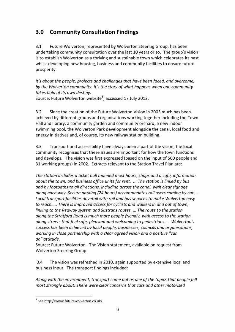
3.0 Community Consultation Findings 3.1 Future Wolverton, represented by Wolverton Steering Group, has been undertaking community consultation over the last 10 years or so. The group’s vision is to establish Wolverton as a thriving and sustainable town which celebrates its past whilst developing new housing, business and community facilities to ensure future prosperity. It's about the people, projects and challenges that have been faced, and overcome, by the Wolverton community. It's the story of what happens when one community takes hold of its own destiny. Source: Future Wolverton website8, accessed 17 July 2012.
3.2 Since the creation of the Future Wolverton Vision in 2003 much has been achieved by different groups and organisations working together including the Town Hall and library, a community garden and community orchard, a new indoor swimming pool, the Wolverton Park development alongside the canal, local food and energy initiatives and, of course, its new railway station building. 3.3 Transport and accessibility have always been a part of the vision; the local community recognises that these issues are important for how the town functions and develops. The vision was first expressed (based on the input of 500 people and 31 working groups) in 2002. Extracts relevant to the Station Travel Plan are: The station includes a ticket hall manned most hours, shops and a cafe, information about the town, and business office units for rent. ... The station is linked by bus and by footpaths to all directions, including across the canal, with clear signage along each way. Secure parking (24 hours) accommodates rail users coming by car…. Local transport facilities dovetail with rail and bus services to make Wolverton easy to reach….. There is improved access for cyclists and walkers in and out of town, linking to the Redway system and Sustrans routes. … The route to the station along the Stratford Road is much more people friendly, with access to the station along streets that feel safe, pleasant and welcoming to pedestrians…. Wolverton's success has been achieved by local people, businesses, councils and organisations, working in close partnership with a clear agreed vision and a positive "can do" attitude. Source: Future Wolverton - The Vision statement, available on request from Wolverton Steering Group. 3.4 The vision was refreshed in 2010, again supported by extensive local and business input. The transport findings included: Along with the environment, transport came out as one of the topics that people felt most strongly about. There were clear concerns that cars and other motorised
8 See http://www.futurewolverton.co.uk/

10
vehicles dominate the town and that movement as a pedestrian or cyclist is difficult and – at times – dangerous. Many of these issues were in the original vision and concern ease of movement and the best use of space. Key points raised included: • movement of cars, buses, people and bikes around Wolverton; • access to public transport – bus routes and siting of bus stops, cycle route to the railway station, and parking at the station Source: “Refreshing the Vision” report available from the Future Wolverton website 3.5 Most recently, in February 2012, a series of Neighbourhood planning workshop events was held9. Wolverton is one of the Government’s Neighbourhood Planning Frontrunner projects. The event, involving over 200 local people, was supported by The Prince’s Foundation, and will lead to one of England’s first statutory Neighbourhood Plans. It is expected that further work on the plan will be led by Wolverton & Greenleys Town Council and Wolverton Steering Group with support from Milton Keynes Council. 3.6 A key overall issue arising from this Neighbourhood Plan consultation was: Connectivity / movement and public realm within the town centre, particularly between and including the Square, The Agora /Church Street area, Stratford Road / Tesco and Glyn Square 3.7 This overall issue became specific to the station when people were asked to identify locations, by sticking a red dot to a map, which they most liked or disliked. This found: the stretch of Stratford Road leading to Wolverton Railway Station also had relatively dense concentrations of red dots, indicating that residents were dissatisfied. 3.8 The overall Neighbourhood Plan strategy has as one of its’ four components a: strategy to improve connectivity through town centre including routes linking the Square to Stratford Road and a more accessible route to the train station
3.9 Access to the station is therefore closely linked to a broader debate about the future of Stratford Road. The survey of conditions on this important route to the station summarised at section 2 above found a number of issues for all types of users - pedestrians, cyclists, bus passengers and car traffic. 3.10 Specific measures on Stratford Road are included in the Action Plan at the end of this report for implementation in the short to medium term. Milton Keynes Council, the Highway Authority, was party to the agreement and is expected to lead on implementation, supported by Wolverton Steering Group. The measures are: 1. Railway Station Approach- Footway widening & enhanced station gateway 2. Station Link 1: Railway Bridge Environmental improvements & enhanced rail-bus interchange
9 The Final Report is available at http://www.futurewolverton.co.uk/20/Neighbourhood-Plan

11
3. Station Link 2: Stratford Rd ‘Canyon’ Widened foot-cycle path & traffic calming 3.11 In summary, the Wolverton Vision, in original and refreshed versions, supports issues identified in section 2 above, and summarises key points for improvement. The Neighbourhood Plan process has brought together important stakeholders, including the Highway Authority, and they are already engaged in supporting work which is very much in line with the Travel Plan objectives.
12
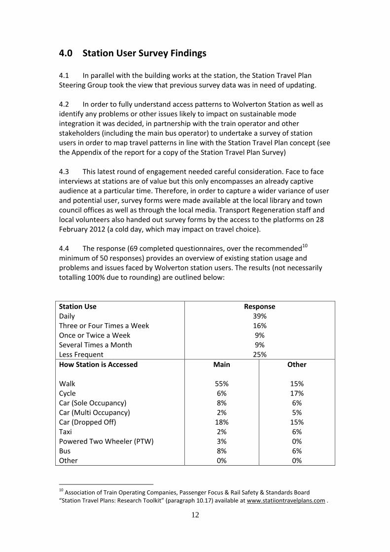
4.0 Station User Survey Findings 4.1 In parallel with the building works at the station, the Station Travel Plan Steering Group took the view that previous survey data was in need of updating. 4.2 In order to fully understand access patterns to Wolverton Station as well as identify any problems or other issues likely to impact on sustainable mode integration it was decided, in partnership with the train operator and other stakeholders (including the main bus operator) to undertake a survey of station users in order to map travel patterns in line with the Station Travel Plan concept (see the Appendix of the report for a copy of the Station Travel Plan Survey) 4.3 This latest round of engagement needed careful consideration. Face to face interviews at stations are of value but this only encompasses an already captive audience at a particular time. Therefore, in order to capture a wider variance of user and potential user, survey forms were made available at the local library and town council offices as well as through the local media. Transport Regeneration staff and local volunteers also handed out survey forms by the access to the platforms on 28 February 2012 (a cold day, which may impact on travel choice). 4.4 The response (69 completed questionnaires, over the recommended10 minimum of 50 responses) provides an overview of existing station usage and problems and issues faced by Wolverton station users. The results (not necessarily totalling 100% due to rounding) are outlined below:
Station Use Daily Three or Four Times a Week Once or Twice a Week Several Times a Month Less Frequent
Response 39% 16% 9% 9%
25%
How Station is Accessed Walk Cycle Car (Sole Occupancy) Car (Multi Occupancy) Car (Dropped Off) Taxi Powered Two Wheeler (PTW) Bus Other
Main
55% 6% 8% 2%
18% 2% 3% 8% 0%
Other
15% 17% 6% 5%
15% 6% 0% 6% 0%
10
Association of Train Operating Companies, Passenger Focus & Rail Safety & Standards Board “Station Travel Plans: Research Toolkit” (paragraph 10.17) available at www.statiiontravelplans.com .

13
4.5 Data for comparing access to Wolverton with other stations nationally is not readily available. We do however have data from Accrington, Lancashire, which was part of the national Travel Plan pilot programme. This station (like Wolverton) serves a local population in a former industrial town, although Accrington Station is located in the heart of the Town Centre rather than “on the edge” as in the case of Wolverton. How people reach Accrington station is shown below, with the Wolverton figures repeated for ease of comparison.
Accrington Wolverton (main mode)
Main mode of access to station June 2010 March 2011 Feb 2012
Walk 62% 59% 55%
Cycle 2% 1% 6%
Car 19% 19% 28%
Train (changing trains) 1% 2% N/A
Taxi 6% 9% 2%
Bus 10% 10% 8%
Other, Powered Two Wheeler 0% 0% 3%
Source: “Accrington EcoStation Research Findings” prepared by Eden Business Analysts in 2011. 4.6 The results for Wolverton and Accrington are broadly similar. Walking is the main access mode, as you would expect for a local station. Cycling is higher at Wolverton than Accrington, reflecting probably higher levels of cycling generally in the area. Car use at Wolverton (28% of the modal share) is rather higher than for Accrington (19% of the modal share). The figures suggest some scope for increasing bus use at Wolverton - both urban areas enjoy established urban bus networks. 4.7 Overall, around 70% of rail users use sustainable modes of access (i.e. walk/cycle/bus) to the station. This is a positive finding. As expected, given the local role of the station, walking is the single most important mode of access. Cycling & car drop off are also well used modes of access. The relatively large numbers of people who walk or cycle but other than as their main mode of travel (32% of survey respondents) indicate that encouraging these people to walk or cycle more regularly could have a large beneficial impact on travel behaviour. These patterns form the starting point for future improvements. 4.8 At this stage it is also worth considering stated reasons for mode choice from the station users:
Lack of buses at time of travel 19%
Poor Cycle Routes/Parking 14%
Lack of Car Parking & Charges 16%
Safety 3%
Information on Choice 4%

14
4.9 Lack of buses and cycle infrastructure between where people live and the station is clearly having an impact on sustainable access to the station. As an example, 41% of those surveyed cited bus as the preferred mode of access if it existed. This is a significant opportunity. Other issues concern the lack of connectivity between the station and the Redway Cycle Network, pedestrian safety in particular along Stratford Road, and information about access options. 4.10 The survey has highlighted a range of barriers to access, not only to sustainable options but also in a more general sense. These various barriers are clearly contributing to longer journeys to access the national rail network with 80% of consultees using nearby Milton Keynes station and 14% Bletchley on a regular basis as a result of better facilities/services. 4.11 Wolverton station has a clear role to play, not just in providing good services for the local community to access employment, education, leisure etc. but also in relieving the pressure on nearby Milton Keynes station and associated road infrastructure. 4.12 The station at Wolverton needs to be more recognised as an important local transport hub. Rail heading, in particular to nearby Central Milton Keynes, is putting unnecessary pressure on other stations not to mention the environmental impact of additional travel. However, the reasons for rail heading at peak times is not entirely clear, since the difference between season tickets from Wolverton or Milton Keynes does not seem to be sufficient (e.g. 40 pence more expensive from Wolverton for a 7 day pass to London) to encourage this behaviour. Off peak “bunching” of rail services may however encourage people to travel to Central Milton Keynes, where rail services are more frequent. Milton Keynes Council could seek more even off peak service patterns through its discussions with train operators and rail authorities, for example, in franchise consultations. 4.13 Lack of facilities at Wolverton, especially lack of a full-time booking office selling a full range of tickets, is clearly an issue prior to opening of the new station (for 31% of consultees), as is the introduction of better more integrated bus services (15% of consultees). 4.14 In conclusion, travel to Wolverton station is already predominantly by sustainable modes of transport. However, the figures indicate potential particularly for increased local bus use and cycling. Car parking is always likely to be limited by space availability in the station area and, as rail use grows, will become an increasing problem.

15
5.0 Developing Solutions – the Action Plan 5.1 Since the introduction of the Station Travel Plans concept, the Department for Transport’s “Better Stations” report has been published11, in November 2009, with a view to providing guidance on station development. While in some respects Wolverton does meet ‘Better Stations’ criteria it is lacking in a number of areas, in particular access by bus. 5.2 The Action Plan and its recommendations take account of “Better Stations” recommendations as well as consultation with the local community (as set out in section 3 above) and stakeholders London Midland, Arriva, Milton Keynes Council, Future Wolverton, Wolverton and Greenleys Town Council and local pedestrian and cycling representatives. 5.3 The Action Plan is structured in terms of short, medium and longer term initiatives. Short term initiatives could reasonably be undertaken within the next year, making the most of the new station scheme. Initiatives are also designated on the basis of low, medium or high cost. Low cost initiatives are likely to be below £15-20,000 at current prices. It should be noted that the high cost initiatives are mainly for the longer term! Priorities are assigned, partly on grounds of cost and impact, but inevitably there is some element of professional judgement. Some measures, such as bus stop relocation, cycle route extension and pedestrian signage, should be taken in a broader network context – these measures are likely to have impacts beyond the station. 5.4 Finally, we emphasise the importance of involving stakeholders in ongoing management – this is the key to success of Travel Plans.
11
Available at http://www.dft.gov.uk/publications/better-rail-stations/

16
Wolverton Station Travel Plan - Action Plan
Action Number
Time Description Impact Cost and funder
Lead Priority
1 Short Communicate with the local community and rail users about Travel Plan findings, opportunities and the planned forum, through an existing newsletter or a special leaflet.
High Low Wolverton Steering Group
High
2 Short Set up a Travel Plan Forum, responsible for overseeing implementation of the Travel Plan. Members to include MK Council (coordinator), Wolverton Steering Group, London Midland, Arriva, New Bradwell Parish Council, Marston Vale Community Rail Partnership, Milton Keynes Rail Users Group & Wolverton & Greenleys Town Council and Destination MK. To meet initially every 3 months to maintain progress. Once medium term initiatives are underway, meetings could be 1 per year. “All Change” has been suggested as a brand for this.
High Low MK Council High
3 Short Design & Implement Travel Plan Information Strategy at the new Station, encompassing maps, bus information, information about local attractions (e.g. the Canal & town centre), local business opportunities and the history of the station and local area. Liaise with the local press, local schools & other local groups to inform and then promote the improvements. Consider the use of branding (as above), web links to relevant partner organisations and the use of social media.
Medium Low Travel Plan Forum High
4 Short Take forward design options for better bus connections. Improve passenger facilities, particularly at the Stratford Road stop, and relocate the bus stop closer to the station, along the lines outlined in the Neighbourhood Plan findings. If bus stop relocation involves diverting vehicles, impacts on the wider bus network performance must be considered.
High Medium MK Council & Arriva
Medium

17
Action Number
Time Description Impact Cost and funder
Lead Priority
5 Short Assess options for creating Redway cycle route connections between New Bradwell, the station and Wolverton town centre, via Stratford Road.
High Low – Medium
MK Council, Wolverton Steering Group, Sustrans.
High
6 Short Revise bus timetables to show Wolverton Station as a destination. Medium Low MK Council & Arriva
Medium
7 Short Assess opportunities for direct bus services from a wide range of places, e.g. Stony Stratford, Old Wolverton and Newport Pagnell
High Medium-High
MK Council & Arriva
High
8 Short Design pedestrian signage strategy (as soon as the preferred bus stop location is identified). This should not be undertaken in isolation from other pedestrian signs for the town, in line with Neighbourhood Plan findings.
Medium Low MK Council, Wolverton Steering Group
Medium
9 Short Assess scope to widen pedestrian footway and install a pedestrian crossing and/or to reduce traffic speeds and/or wider environmental/public realm improvements on Stratford Road, as part of the Neighbourhood Plan implementation.
Medium Medium-High
MK Council, Wolverton Steering Group
Medium
10 Short Review the adequacy of new cycle parking facilities at the station. Medium Low MK Council, London Midland
Medium
11 Short Integrate the station and local rail user needs in future electric vehicle schemes. For example, consider electric vehicle charging point at the station to support the E-car club and future electric bus access.
Medium/High
High MK Council, Arriva, London Midland
High
12 Short Consider the scope for retaining the car parking on Haversham Road for off-peak/leisure rail users
Medium Medium MK Council High
13 Short Consider scope for new alliances to promote sustainable transport, for example promoting walking and cycling from the station with Health Promotion and the Canal and River Trust (owner of the Grand Union Canal). There may also be scope for community food/landscaping initiatives at the new station.
Medium Low Travel Plan Forum Medium

18
Action Number
Time Description Impact Cost and funder
Lead Priority
14 Short Review ticket office hours of operation, in conjunction with take-up of new retail facility, to provide a welcome to the station. Note that increasing rail staff costs is contrary to national level objectives for reducing rail operation costs.
Medium Medium London Midland Low
15 Medium Monitor user feedback and travel patterns preferably on an annual basis.
High Low Travel Plan Forum High
16 Medium Work with local attractions, arts, heritage and sports groups, etc. to consider how to develop and market itineraries around local transport to increase the number of inbound visitors thereby helping to contribute to Wolverton’s Visitor Economy.
Medium Low Travel Plan Forum
Medium
17 Medium Implement preferred option for connecting cycle route between town centre, station & New Bradwell.
High Medium MK Council, Wolverton Steering Group, Sustrans.
High
18 Medium Implement bus interchange improvements High Medium MK Council, Arriva High
19 Medium Implement pedestrian signage strategy & any highway/footway improvements
High Low MK Council, Wolverton Steering Group
Medium
20 Medium In conjunction with wider MK initiatives, introduce a car share scheme. This could include preferential parking at the station (with attention given to enforcement ).
Medium Low MK Council, London Midland
Medium
21 Medium/Long
Consider more frequent/evenly patterned rail services to Wolverton, to reduce the need for Wolverton residents to “railhead”, driving to/parking at MK Central station.
Medium/High
High London Midland, MK Council
Medium

19
6.0 Conclusions 6.1 This report has set out an Action Plan, with a practical and realistic set of recommendations and initiatives in line with future sustainable development of Wolverton town and station. It has been informed by local and rail user needs, established through previous community and stakeholder consultation, travel behaviour surveys, an assessment of conditions on the ground and national “Better Stations” recommendations. 6.2 The involvement of partner organisations, together with a proposed Wolverton Station Travel Plan Forum, is set out in the Action Plan. The Station Travel Plan builds on earlier work undertaken by, in and for the town as part of the Wolverton Vision and the Neighbourhood Plan, and there are symbiotic relationships between these broader initiatives and the Travel Plan. The Station Travel Plan, however, has a distinct role and focus for improving access to the station. 6.3 Travel Plans are useful means for improving coordination between the rail industry (with lead responsibility for measures at the station), the local highway authority, Milton Keynes Council (with lead responsibility for measures on the surrounding highway), principal local bus operator Arriva and the local community. Experience shows that a combination of physical improvements on the ground as well as information, marketing and promotion works best, to help change behaviour. The Travel Plan challenge is to achieve a balance between these different types of measure, and to secure the ongoing involvement and enthusiasm of the various participants. 6.4 The new station building scheme is a turning point for realising new transport options for Wolverton. To make the most of this asset, the Travel Plan can enable work to improve access to the station and raise awareness of these new opportunities. With rail use nationally at record levels and still growing, rail is set to play its part in the sustainable future of Wolverton.

20
7.0 Appendix Station Travel Plan Survey

This survey is to help us better understand how people currently choose to travel and why they choose those methods of transport. The data collected will be to help improve and widen travel choices. The survey will only take a few minutes to complete.
Wolverton Steering Group is leading on the delivery of the regeneration and development in Wolverton. Partners on the group include Wolverton & Greenleys Town Council, Churches Together in Wolverton, Wolverton Business & Enterprise Alliance, Volunteer/Community sector, Wolverton Society for Arts & Heritage and Milton Keynes Council.
Please fill in and return this survey:
• At Wolverton Station between 6am and 12 noon on 7th February 2012
• At the Ticket Office at Wolverton Station (when open) up until 7th February 2012
• By dropping off or posting to the Town Hall/Library, Creed Street, Wolverton, MK12 5LY
You can also download it from www.futurewolverton.co.uk
For further information about this survey please contact John French, Transport Regeneration Ltd, on 01284 723266.
For any information about the current station works, contract John McLaughlin at Milton Keynes Council on 01908 253083 or [email protected]
1. Your home postcode ?
_________________________________
2. How often do you generally use
Wolverton Station? (Please tick one only)
Daily (5 or more days a week) �
Three or four times a week �
Once or twice a week �
Several times a month �
Less frequently �
3. Your reasons for catching a train from
Wolverton Station?
(Please tick one main reason and
as many other reasons as apply.)
Main Other
Commuting to/from work � �
On company business � �
Commuting to/from education � �
Shopping � �
Visiting friends/relatives � �
Leisure � �
It’s my nearest station � �
Other (please specify) � �
_________________________________
4. a) How do you normally get to the
station? (Please tick one main reason and
as many other reasons as apply.)
Main Other
Walk � �
Cycle � �
Car - drive alone � �
Car - share � �
Car - dropped off � �
Taxi (private hire/hackney) � �
Motorcycle/Moped/Scooter � �
Bus � �
Other (please specify) � �
_________________________________
Wolverton Station Travel Plan Survey February 2012 Wolverton station will shortly be transformed by the investment in the new station building which is due to be completed by Spring 2012, including improvements to parking, access and nearby pavements.

4. b) If available, what alternative
methods of getting to the station would
you consider?
Car share/car club �
Bus �
4. c) If you use a car what would help
you use alternative methods?
____________________________
____________________________
5. Why do you use this means of transport
to the station? (Please explain)
Convenience �
Cost saving �
Time saving �
No buses or infrequent buses at
the times I want to travel �
Lack of, or poor cycle routes to
the station �
Not enough safe cycle storage �
Lack of, or poor pedestrian routes
to the station �
It is too far to walk or cycle to
the station �
Safety/personal security �
Not enough car parking �
Car parking charges too high �
Car required for business trips �
Visit shops/leisure facilities on way
to or from the station �
I do not know of any other way to
get to the station �
Other (please specify) �
_________________________________
6. What improvements would you like to see
for getting to and from the station?
________________________________
________________________________
________________________________
7. Do you ever use Milton Keynes Central
or Bletchley train stations?
Yes � No �
If yes, why? (tick as many as apply)
MK Bletchley
Better facilities � �
Easier to get to by bus � �
Better parking � �
Cheaper rail fares � �
Better train services � �
Ongoing road works � �
Other (please specify) � �
_________________________________
Thank you for completing this survey.
It would be helpful if you give us your contact details but you do not need to do so. Your details will be kept in accordance with the Data Protection Act
Your Name(s):
_________________________________
Your Email address:
_________________________________
Your Address (optional):
_________________________________
_________________________________
Your Phone Number:
_________________________________
� Please email me progress updates
This information will be recorded on a database Marie Osborne is registered under the Data Protection Act.
Printed and published by Wolverton and Greenleys Town Council, Town Hall, Creed Street, Wolverton, Milton Keynes, MK12 5LQ on behalf of Wolverton Steering Group.