WMO New Meteorological Services Supporting ATM€¦ · New Meteorological Services Supporting ATM ....
28
MET=ATM Workshop Mexico City Oct 2012 1 World Meteorological Organization Working together in weather, climate and water New Meteorological Services Supporting ATM Meteorological Services in the Terminal Area (MSTA) …providing MET services to support a move from Air Traffic Control (ATC) to more integrated and collaborative Air Traffic Management (ATM) WMO
Transcript of WMO New Meteorological Services Supporting ATM€¦ · New Meteorological Services Supporting ATM ....

MET=ATM Workshop Mexico City Oct 2012 1
World Meteorological Organization Working together in weather, climate and water
New Meteorological Services Supporting ATM
Meteorological Services in the Terminal Area (MSTA)
…providing MET services to support a move from Air Traffic Control (ATC) to more integrated and collaborative Air Traffic Management (ATM)
WMO

MET=ATM Workshop Mexico City Oct 2012
Outline
• The challenge • MSTA objective • Guiding principles • MSTA initial concepts • Outstanding questions • Next Steps...

MET=ATM Workshop Mexico City Oct 2012
The challenge • ICAO Annex 3 stipulates meteorological data
products • …In support of aerodrome operations
– Aerodrome Forecast (TAF) – Trend-type Landing Forecast (TREND) – Aerodrome Warnings
• …In support of FIR, regional, global operations – AIRMET/SIGMET – WAFC charts
• Use highly-condensed, coded, textual format

MET=ATM Workshop Mexico City Oct 2012
The challenge • Services no longer meet the needs of modern
aircraft operators and other users of the ANS – Not specific enough - Gap between aerodrome and FIR/global scale – No info on some important parameters (crosswind,
headwind, winter conditions such as snow fall rate) • Various Member states developing MET
services to address their needs • The problem has been recognized by ICAO
– “MET services required by ATM to optimize traffic flow in the en-route and terminal areas”

MET=ATM Workshop Mexico City Oct 2012
What the WMO is doing • An expert team was established by the Commission for Aeronautical
Meteorology (CAeM) of the World Meteorological Organization (WMO) at its 13th Session in 2006, and re-constituted at its 14th Session in 2010
• Name changed from New Terminal Forecast (NTF) to Meteorological Services for the Terminal Area (MSTA) to reflect that the new services will supplement, rather than replace, the TAF
• Supported by a Task Team on User Needs (TT-UN) to liaise with ICAO groups – Aerodrome Meteorological Observation and Forecast Study Group
(AMOFSG) and its Ad Hoc Working Group – Air Traffic Management Requirements and Performance Panel
(ATMRPP). • … and aviationstakeholder (IFALPA, IFATCA, IATA, ICAO)

MET=ATM Workshop Mexico City Oct 2012
6
MSTA objective • … to address these new and evolving ATM user
needs and to avoid the costly parallel development of similar weather products of varying and confusing data formats
• … to develop a detailed MSTA proposal, supported by ICAO and the aviation user communities, ready for endorsement by the next Conjoint ICAO MET/AIM Divisional Meeting/WMO CAeM Session (currently scheduled for 2014) and reflected in ICAO Annex 3.

MET=ATM Workshop Mexico City Oct 2012
What it will be • A web-based net-centric user-oriented service
– Fed by a database that will support other products such as charts and a simplified text version for uplink to the cockpit
– Gridded/object data would be available for direct integration into users’ decision-support systems.
• Graphics:Colour-coded for ease of use (“high glance value”) – Red :
• High impact on ATFM (action recommended) – Yellow :
• Possible impact to ATFM (manageable) – Green/blue?
• Chance of impact is low but cannot be excluded • Detailed weather scenario/conditions/threshold
determined by MET Authority and user

MET=ATM Workshop Mexico City Oct 2012
Role of Services in ICAO ASBU’s
• Need for coordinated development and timing • A dynamically expandable framework…. Starting
with low-hanging fruit (convection, winds, winter weather)
• Scalable enough to handle future ASBU requirements
• Expandable to include other parameters as techniques become available and support other needs such as environmental constraints

MET=ATM Workshop Mexico City Oct 2012
MSTA timeframe • Three timeframes to support different needs
• Nowcast (0 to 1-2 hours)
– High-resolution, rapid update – Supports tactical decision-making
• Short-term forecast (up to 6 hours) – Lower resolution – Covers greater area – Supports tactical decision-making
• Outlook (up to 2 days ahead) – Supports pre-tactical decision-making
9

MET=ATM Workshop Mexico City Oct 2012
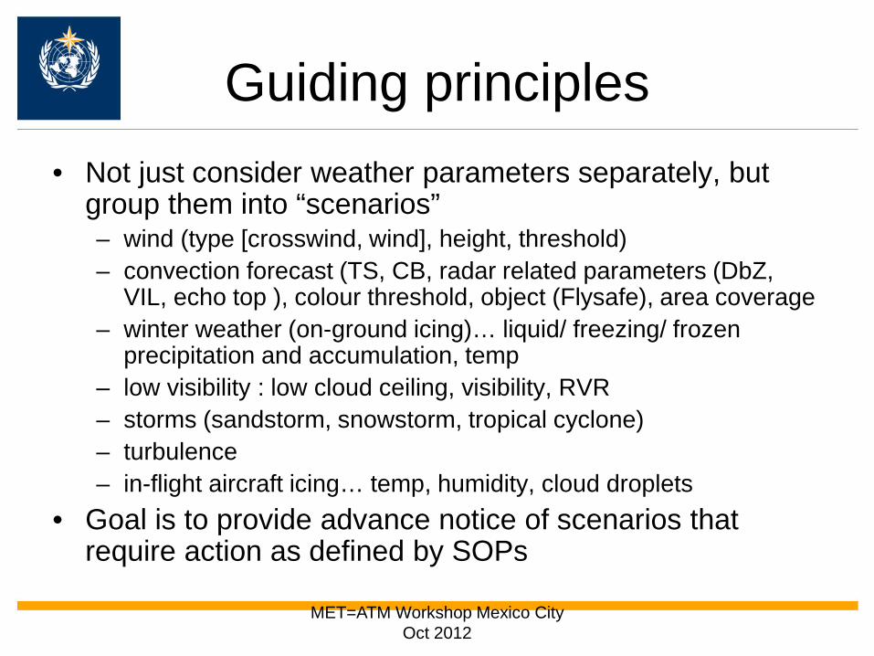
Guiding principles • Follow needs as identified by ICAO, including elements, type of
guidance (deterministic or probabilistic), attainable accuracy • Tie in with individual Member/State initiatives such as NextGen Wx
and SESAR, overarching ICAO GANP • Focus on operations in and around aerodromes, including airport
operations, e.g. de-icing, runway maintenance, ramp operations • Report on accuracy and performance in terms and for parameters
that are meaningful to users; e.g. – Not just the MAE of wind speeds, but of crosswind component – When weather parameters cross specific thresholds, measure how
much “lead time” is provided • Go beyond basic met parameters to also consider their impact on
ATM; i.e. bridge the gap – Provide support to the determination of the active runway – Guidance for whether flights can operate visually
MET=ATM Workshop Mexico City Oct 2012
Guiding principles • Not just consider weather parameters separately, but
group them into “scenarios” – wind (type [crosswind, wind], height, threshold) – convection forecast (TS, CB, radar related parameters (DbZ,
VIL, echo top ), colour threshold, object (Flysafe), area coverage – winter weather (on-ground icing)… liquid/ freezing/ frozen
precipitation and accumulation, temp – low visibility : low cloud ceiling, visibility, RVR – storms (sandstorm, snowstorm, tropical cyclone) – turbulence – in-flight aircraft icing… temp, humidity, cloud droplets
• Goal is to provide advance notice of scenarios that require action as defined by SOPs

MET=ATM Workshop Mexico City Oct 2012
12
“Live” demo of sample MSTA Integrated Display available at: http://www.msta.weather.gov.hk/ntf_interface/ntf_interface.phtml
MSTA initial concept: Hong Kong Observatory
TAF VHHH 022300Z 0300/0406 8000 FEW020 SCT040 TX28/0306Z TN22/0223Z TEMPO 0305/0307 2000 TSRA +SHRA FEW008 SCT012CB= Significant weather forecast for the next 24 hours (0306-0406 UTC) Intense thunderstorms and CB associated with a trough of low pressure will move northeast away from NTF region gradually within the next 6 hours. Visibility will drop to around 1500m in heavy showers. There will be high chance of gusts (80%) reaching 40 knots at VHHH during 0306-0309 UTC Outlook for 24-48 hours (0406 - 0506 UTC) Typhoon Ketsana is expected to enter the South China Sea. Embedded CB and isolated thunderstorms will start to affect the southeastern part of NTF region from around 0406-0412 UTC. The chance of northerly crosswinds reaching 20 kt with significant low level turbulence will become medium to high (60-80%) at VHHH during 0418-0506 UTC.
TAF Textual description
tabular
graphics

MET=ATM Workshop Mexico City Oct 2012
13
MSTA initial concept: Hong Kong Observatory

MET=ATM Workshop Mexico City Oct 2012
14
MSTA initial concept: Hong Kong Observatory

MET=ATM Workshop Mexico City Oct 2012
MSTA initial concept (Japanese Met Agency)
Wind Crosswind comp
… with pcpn
Vsby CIG Convection
Snow-fall rate
Wind shear
Red >=40 >=30 >=25, MDT to HVY
<500m <200 ft TS overhead
>= 1cm/h
>=30 at sfc. >=50 blw 5000
Yellow >=30, gust to >=50
>=25 >=20, MDT to HVY
TS in vcnty
MDT or HVY
Blue TS in TAF

MET=ATM Workshop Mexico City Oct 2012
MSTA initial concept (Japanese Met Agency)
Weather Element
Weather scenario causing impact to ATFM
Impact to ATFM
CB Proportion occupied with CB (top >= FL300) in the sector >=50%
Because of the air route adjustment before the airplance depart, the possibility of the air traffic flow disturbance is very high
RED (sector) Weather Element
Weather scenario causing impact to ATFM
Impact to ATFM
CB CB exits on the selected air ways or selected area
If CB exists on the selected airways, many aircrafts may deviate or change the route
Yellow (sector)
Lead time

MET=ATM Workshop Mexico City Oct 2012
MSTA initial concept (Japanese Met Agency)
Tabular format
sample
Graphical format (sample)

MET=ATM Workshop Mexico City Oct 2012
Automated Thunderstorm Alert Service (Australia)
18
International Trend

MET=ATM Workshop Mexico City Oct 2012
Météo-France Thunderstorm detection and forecast for Air Traffic Control Application de Signalisation et Prévision des Orages pour le Contrôle Aérien (ASPOC)
• Convection monitoring based on weather radar and lightning data
• 4 intensity (dBZ) levels relevant to ATC operations.
• 30-min forecast
• Trial ASPOC-3D, based on wx radar, lightning data and satellite imagery (cloud top, Zmax)
19
International Trend

MET=ATM Workshop Mexico City Oct 2012
MIT Lincoln Lab Route Availability Planning Tool (RAPT) • Operational at New York.
Integrated into FAA Integrated Terminal Weather System (ITWS)
• An automated tool
intended to help ATC and airline dispatchers determine the specific departure routes and departure times that will be affected by significant convective weather
20
International Trend
TAF VHHH 141700Z 1418/1524 12010KT 7000 FEW010 SCT025 BKN060 TX29/1506Z TN24/1422Z TEMPO 1418/1421 VRB20G30KT 2500 TSRA +SHRA FEW008 SCT012CB BKN040 TEMPO 1421/1503 4000 SHRA=

MET=ATM Workshop Mexico City Oct 2012
Remaining questions 1. Consensus on requirements for probabilistic forecasts
1. how to generate and encompass this information such that it fulfils user needs and is used appropriately?
2. the new MET service has to be supported by a well
documented and transparent validation and verification (V&V) process. 1. What relevant verification metrics to be used to include the user
perspectives in the V&V process? 2. Should we first define the operationally desirable accuracy of
forecasts from user’s perspective, and take into account the current/potential technological advancements in the next decade, as currently stipulated in Attachment B of ICAO Annex 3? Or something more visionary is needed considering the new requirements and operational environment of CDM/SWIM ?

MET=ATM Workshop Mexico City Oct 2012
Remaining questions 3. the MSTA proposal needs to use or integrate the impact
of weather on operations. 1. how should the MSTA concept do the bridging of the gap
between basic MET information (e.g.observations and NWP parameters) and user impact (e.g. TMA capacity)?
4. in the MSTA proposal to be considered by the
ICAO/WMO Conjoint Meeting 1. what should be included as Core SARPs (i.e. Standards and/or
Recommended Practices), Appendices (e.g. Model Charts and Forms), Attachments (e.g. desirable accuracy of forecasts) and/or guidance material (i.e. Manuals/Guides) respectively?

MET=ATM Workshop Mexico City Oct 2012
Next Steps...
• Coming meetings – ATMRPP Meeting (Oct 2012, Montréal) – AMOFSG/10 (June 2013, Montréal)
• Workplan
– Finalize details – Perhaps conduct some formal operational evaluation

MET=ATM Workshop Mexico City Oct 2012
What inviting this group to do
• Note the MSTA development • Provide feedback on proposal and
questions raised

MET=ATM Workshop Mexico City Oct 2012
25
MSTA website
Prototypes and questionnaire to collect feedback
http://msta.weather.gov.hk/ Login : msta
Password mstamsta

MET=ATM Workshop Mexico City Oct 2012
• Intensify efforts in user engagement • Establish new ICAO Project Team (MARIE-PT)
• Adressing key stakeholders in ATM: – Establish contact and working relationship with ATMRPP
• Better understand impact of weather on ATM decision making process
• Iterative approach in close cooperation with experienced ATS practitioners
• Seek to understand effect on operation planning • Holistic view of sub-regions rather than single
aerodrome? 26
Address user feedback

MET=ATM Workshop Mexico City Oct 2012
• Prototypes on convection and wind presented at various international forums
• Users support (IFALPA, IFATCA, IATA, ICAO) : – Continual development of conceptual models – Establishment of user requirements (e.g. conjoint
workshops or seminars effective for integrated user consultation)
• Wind, thunderstorms, low visibility and cloud ceiling, winter weather, turbulence
27
User engagement

MET=ATM Workshop Mexico City Oct 2012
• Consider both En-route and Terminal area ( approach/departure)
• Need to translate MET information to potential impact to air traffic flow/capacity together with ATM experts
• Objective Verification/Validation needed for risk assessment (need for user-relevant measures)
• Probability forecast approach to enter safety risk assessment
• Need for integration into ATC decision support framework
• Strengthen consultation with representatives of user groups including ATM, airlines, pilots,
28
User Feedback