WISCONSIN - USGS Effects of cranberry bog operations on the hydrology and ... 1996 runoff as percent...
110
WISCONSIN Water-Resources Investigations U.S. GEOLOGICAL SURVEY Open-File Report 97-351 1997 USGS science fora changing world
Transcript of WISCONSIN - USGS Effects of cranberry bog operations on the hydrology and ... 1996 runoff as percent...
WISCONSINWater-Resources Investigations
U.S. GEOLOGICAL SURVEY Open-File Report 97-351
1997 USGSscience fora changing world

WATER-RESOURCES INVESTIGATIONS IN WISCONSIN
Compiled by D.E. Maertz
U.S. GEOLOGICAL SURVEY Open-File Report 97-351
Madison, Wisconsin 1997

U.S. DEPARTMENT OF THE INTERIOR BRUCE BABBITT, Secretary
U.S. GEOLOGICAL SURVEY Gordon Eaton, Director
For additional information write to:
District Chief U.S. Geological Survey 8505 Research Way Middleton, Wl 53562
Copies of this report can be purchased from:
U.S. Geological Survey Branch of Information Services P.O. Box 25286 Denver, CO 80225-0286

CONTENTS
ProgramBasic data collection
Page
001 Collection of basic records-surface water..................................................................!002 Collection of basic records-ground water................................................................ 1000201 Crandon ground water...............................................................................................1200203 Brownfields...............................................................................................................13003 Collection of basic records-water quality.................................................................1400301 Corn herbicides in surface waters in Wisconsin.......................................................1500302 Collection of basic records-Dane County program..................................................16004 Collection of basic records-sediment.......................................................................17006 FEMA flood-insurance study....................................................................................19007 Wisconsin water-use data file ...................................................................................20
Interpretive studies 109 Regional flood-frequency study for urban and rural streams in Wisconsin.............2112301 Menomonie trace element monitoring ......................................................................2412305 RedCliff....................................................................................................................2512309 Water resources on the Bad River Band of Lake Superior Tribe of
Chippewa Indians Reservation ...........................................................................26133 Lake water-quality monitoring, chemical and biological monitoring of
selected lakes ......................................................................................................27145 Occurrence, transport, and simulation of PCB' s in the Lower Fox River................29164 Superfund remedial response support, EPA Region V.............................................31170 Hydrologic investigations of wetland restoration and creation projects...................3217202-05 Trends in water quality and stream habitat for priority watersheds..........................3317209-10172131722117206 Best-management practice evaluation ......................................................................3517212 Lake Superior urban storm-water demonstration project .........................................3717214 Single source sites.....................................................................................................3917217 Tributary phosphorus loading to Lake Mendota and evaluation of load
determination methods........................................................................................4117303 Wisconsin lakes, Green Lake tributary monitoring ..................................................4217312 Assessment of hydrology, nutrient loading, and trophic status of Kirby Lake
near Cumberland, Wisconsin..............................................................................4317313 Assessment of phosphorus loading, winter anoxia, and stage regulation
of Little St. Germain Lake, Vilas County ...........................................................4417314 Assessment of the water quality, hydrology, and biology of Geneva Lake .............45174 Western Lake Michigan drainages National Water-Quality Assessment
(NAWQA)...........................................................................................................46175 Hydrologic and biogeochemical budgets in temperate lakes and their
watersheds, northern Wisconsin.........................................................................4818001 Mercury cycling in lakes
Acidic lakes.........................................................................................................50Hydrologic considerations associated with the artificial acidification of
Little Rock Lake in Vilas County, Wisconsin ..............................................5118101 Assessment of the hydrology, water quality, and biology of Delavan Lake ............52
in

183 Lake Michigan tributary loading ..............................................................................5318302 Lake Superior tributary loading................................................................................54187 Water-quality of urban storm-water runoff in Madison, Wisconsin.........................5518701 Evaluation of the effectiveness of an urban stormwater treatment system
in Madison, Wisconsin........................................................................................56189 Dane County regional hydrologic study ...................................................................5818901 Dane County surface-water model............................................................................59191, Transport and biogeochemical cycling of PCB' s in the Milwaukee River-19101 the importance of algal dynamics .......................................................................60193 North Fish Creek sediment .......................................................................................62194 Ft. McCoy ground-water quality...............................................................................6419402 Fort Sheridan ground-water quality ..........................................................................65195 Ft. McCoy EMD support ..........................................................................................66196 Antarctic hydrologic studies .....................................................................................67197 Florida Everglades mercury cycling .........................................................................68198 Optimum management of ground-water resources in the Lower Fox
River Valley........................................................................................................70199 Evaluation of the effectiveness of vegetated filter strips as a means of
reducing the transport of nutrients and suspended sediment in agricultural areas.................................................................................................71
201 Effects of cranberry bog operations on the hydrology and water quality ofa stream in west-central Wisconsin.....................................................................72
202, Mitigation of future North Fork urbanization impacts on the Pheasant20202 Branch hydrologic system...................................................................................74204 Monitoring and evaluation of the impacts of aircraft and runway deicers
on the Kinnickinnic River surface-water resources............................................76205 Watershed modeling of proposed copper mine impacts using hydrologic
simulation program-Fortran (HSPF)..................................................................78
Completed projects (reports in process) ...................................................................79
Wisconsin District publications................................................................................80
Wisconsin District personnel....................................................................................90
IV

ILLUSTRATIONS
Page
Figure 1. Organization chart of the U.S. Geological Survey, Water Resources Division,Wisconsin District................................................................................................ viii
2. Location of offices in the Wisconsin District.............................................................. ix
3. Funding sources for the water-resources program in Wisconsin for the1997 fiscal year...................................................................................................... xi
4. 1996 runoff as percent of long-term average runoff................................................... xii
5. Comparison of annual discharge at representative gaging stations to thelong-term average discharge for water years 1916-96......................................... xiii
6. Comparison of discharge at representative gaging stations during wateryear 1996 with discharge for 1916-96................................................................. xiv
7. Relation of seasonal water-table levels to long-term means.................................... xviii
8. Location of continuous-record data-collection stations.................................................5
9. Location of network observation wells........................................................................11
10. Location of crest-stage-gage data-collection stations..................................................23

BASIC MISSION AND PROGRAMS
U.S. Geological Survey
The U.S. Geological Survey was established by an act of Congress on March 3,1879, to provide a permanent Federal agency to conduct the systematic and scientific "classification of the public lands, and examination of the geological structure, mineral resources, and products of national domain." An integral part of that original mission includes publishing and disseminating the earth- science information needed to understand, to plan the use of, and to manage the Nation's energy, land, mineral, and water resources.
Since 1879, the research and fact-finding role of the U.S. Geological Survey (USGS) has grown and has been modified to meet the changing needs of the Nation it serves. As part of the evolution, the USGS has become the Federal Government's largest earth-science research agency, the Nation's largest civilian map-making agency, the primary source of data on the Nation's surface- water and ground-water resources, and the employer of the largest number of professional earth scientists in the Nation. Today's programs serve a diversity of needs and users. Programs include:
Conducting detailed assessments of the energy and mineral potential of land and offshore areas.
Investigating and issuing warnings of earthquakes, volcanic eruptions, landslides, and other geologic and hydrologic hazards.
Conducting research on the geologic structure of land and offshore areas.
Studying the geologic features, structure, processes, and history of the other planets of our solar system.
Conducting topographic surveys and preparing topographic and thematic maps and related cartographic products.
Developing and producing digital cartographic data bases and products.
Collecting data on a routine basis to determine the quantity, quality, and use of surface water and ground water.
Conducting water-resource appraisals to describe the consequences of alternative plans for developing land and water resources.
Conducting research in hydraulics and hydrology, and coordinating all Federal water-data acquisition.
Using remotely sensed data to develop new cartographic, geologic, and hydrologic research techniques for natural resources planning and management.
Providing earth-science information through an extensive publications program and a network of public access points.
Along with its continuing commitment to meet the growing and changing earth-science needs of the Nation, the USGS remains dedicated to its original mission to collect, analyze, interpret, publish, and disseminate information about the natural resources of the Nation providing "Earth science in the public service."
VI

Water Resources Division
The mission of the Water Resources Division (WRD) is to provide the hydrologic information and understanding needed for the optimum utilization and management of the Nation's water resources for the overall benefit of the people of the United States. This mission is accomplished, in large part, through cooperation with other Federal and non-Federal agencies, by:
Collecting, on a systematic basis, data needed for the continuing determination and evaluation of the quantity, quality, and use of the Nation's water resources.
Conducting analytical and interpretive water-resource appraisals describing the occurrence, availability, and physical, chemical, and biological characteristics of surface water and ground water.
Conducting supportive basic and problem-oriented research in hydraulics, hydrology, and related fields of science to improve the scientific basis for investigations and measurement techniques and to understand hydrologic systems sufficiently well to quantitatively predict their response to stress.
Disseminating the water data and the results of these investigations and research through reports, maps, computerized information services, and other forms of public releases.
Coordinating the activities of Federal agencies in the acquisition of water data for streams, lakes, reservoirs, estuaries, and ground water.
Providing scientific and technical assistance in hydrologic fields to other federal, state, and local agencies, to licensees of the Federal Energy Regulatory Commission, and to international agencies on behalf of the U.S. Department of State.
vn

Wat
er R
esou
rces
Div
isio
n, W
isco
nsin
Dis
tric
t
Off
ice
of D
istr
ict
Chi
ef:
War
ren
A. G
eber
t
Com
pute
r A
pplic
atio
ns
Uni
t
Bob
Bod
oh
NA
WQ
A P
rogr
am
Cha
rles
Pet
ers
Adm
inis
trat
ive
Uni
t
Ric
k G
rove
r
Hyd
rolo
gic
Syst
ems
and
Dat
a Se
ctio
n
Her
b G
arn
Hyd
roge
olog
ic S
tudi
es
and
Dat
a Se
ctio
n
Jim
Kro
hels
ki
Mad
ison
F.O
. Jo
e H
abal
eM
erri
ll F.
O.
Jeff
Han
igR
ice
Lak
e F.
O.
Tom
Pop
owsk
i
Res
earc
h A
dvis
or
John
Eld
er
Env
iron
men
tal
Stud
ies
Sect
ion
Pet
er H
ughe
s
Publ
icat
ions
Uni
t
Figu
re 1
. Org
aniz
atio
n ch
art o
f the
U.S
. Geo
logi
cal S
urve
y, W
ater
Res
ourc
es D
ivis
ion,
Wis
cons
in D
istri
ct.

46'
45°
92°40 60 MILES
I
Rice Lake (Field off ice)
Merrill (Field office)
Middl0ton (District of ice) Madison
, (Fie|d off jcej
Figure 2. Location of offices in the Wisconsin District.
IX

COOPERATORS
State AgenciesIllinois Department of Transportation Minnesota Pollution Control Agency Wisconsin Department of Agriculture, Trade,
and Consumer Protection Wisconsin Department of Natural Resources Wisconsin Department of Transportation Wisconsin Geological and Natural History Survey
Local AgenciesCity of BarronCity of Beaver DarnCityofBrookfieldCity of Fond du LacCityofHillsboroCity of MadisonCity of MiddletonCity ofPeshtigoCity of River FallsCity of SpartaCity of ThorpCity of WaupunDane County Regional Planning CommissionDane County Department of Public WorksFontana/Walworth Water Pollution Control CommissionGreen Bay Metropolitan Sewerage DistrictMadison Metropolitan Sewerage DistrictRock County Public Works DepartmentSoutheastern Wisconsin Regional Planning CommissionVillage of WittenbergWalworth County Metropolitan Sewerage District
Other Federal AgenciesU.S. Army Corps of Engineers,
Detroit DistrictRock Island DistrictSt. Paul DistrictVicksburg, MS
U.S. Army, Department of Defense, Ft. McCoy Federal Emergency Management Agency Federal Energy Regulatory Commission licensees
Dairyland Power CooperativeNiagara of Wisconsin Paper CorporationNorthern States Power CompanyWisconsin Electric Power CompanyWisconsin Power and Light CompanyWisconsin Public Service Corporation
Other Federal Agencies (continued)Wisconsin Valley Improvement Company
U.S. Environmental Protection Agency
Indian TribesBad River Band of Lake Superior Chippewa Lac du Flambeau Band of Lake Superior Chippewa Menominee Indian Tribe of Wisconsin Oneida Tribe of Indians of Wisconsin Stockbridge-Munsee Band of Mohican Indians
Lake DistrictsCity of MuskegoDruid Lake Protection and Rehabilitation DistrictEagle Spring Lake Management DistrictFowler Lake Management DistrictGreen Lake Sanitary DistrictKirby Lake Management DistrictLittle Arbor Vitae Lake DistrictLittle Cedar LakeLittle Green Lake Protection and Rehabilitation DistrictLittle St. Germain Protection and Rehabilitation DistrictMiddle Genesee Lake DistrictMontello Lake Inland Protection and Rehabilitation
DistrictOkauchee Lake DistrictPotter Lake Rehabilitation and Protection District Pretty Lake Protection and Rehabilitation District Silver Lake Protection and Rehabilitation District Twin Lakes Protection and Rehabilitation District Wind Lake Management District Wolf Lake Management District Town of Auburn Town of Casey Town of Cedar Lake Town of Delavan Town of Kansasville Town of Norway Town of St. Germain Town of Summit Town of Waterford Village of Oconomowoc Lake

Other Federal Agencies695,000
12%
Lake Districts 126,000
2%
Total Funding = 5,976,000
Figure 3. Funding sources for the water-resources program in Wisconsin for the 1997 fiscal year.
XI
SUMMARY OF 1996 HYDROLOGIC CONDITIONS
Streamflow
The statewide average precipitation of 33.37 inches for the 1996 water year was 105 percent of the normal annual precipitation of 31.79 inches for water years 1961-90. Average precipitation values ranged from 77 percent of normal at Trempealeau Dam 6 weather station in west central Wisconsin to 151 percent of normal at Oconto 4 W weather station in northeast Wisconsin (State Climatologist Office, Geological and Natural History Survey, written commun., 1997).
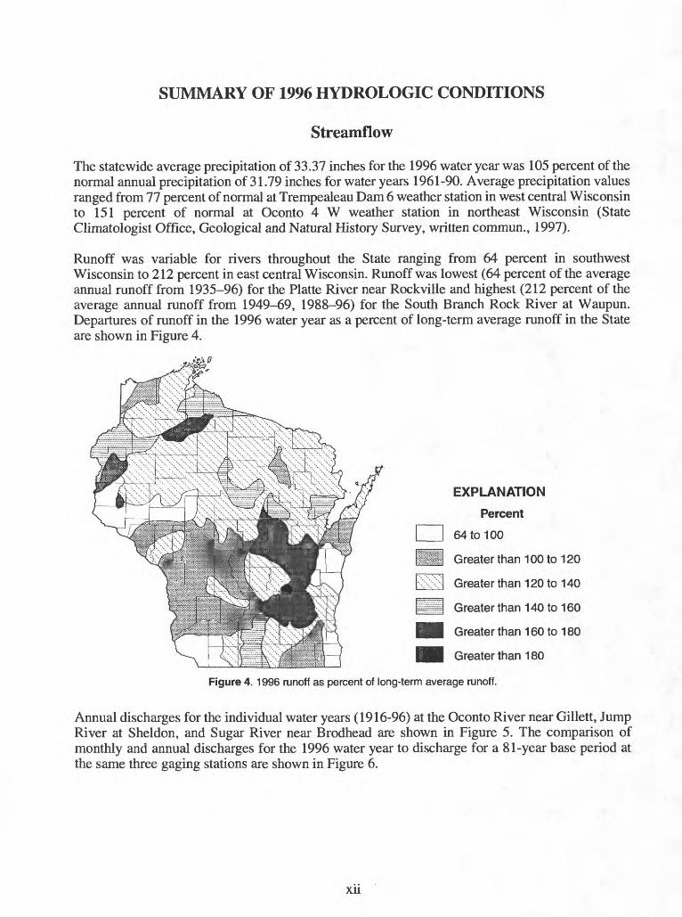
Runoff was variable for rivers throughout the State ranging from 64 percent in southwest Wisconsin to 212 percent in east central Wisconsin. Runoff was lowest (64 percent of the average annual runoff from 1935-96) for the Platte River near Rockville and highest (212 percent of the average annual runoff from 1949-69, 1988-96) for the South Branch Rock River at Waupun. Departures of runoff in the 1996 water year as a percent of long-term average runoff in the State are shown in Figure 4.
EXPLANATION
Percent
64 to 100
Greater than 100 to 120
Greater than 120 to 140
Greater than 140 to 160
Greater than 160 to 180
Greater than 180
Figure 4. 1996 runoff as percent of long-term average runoff.
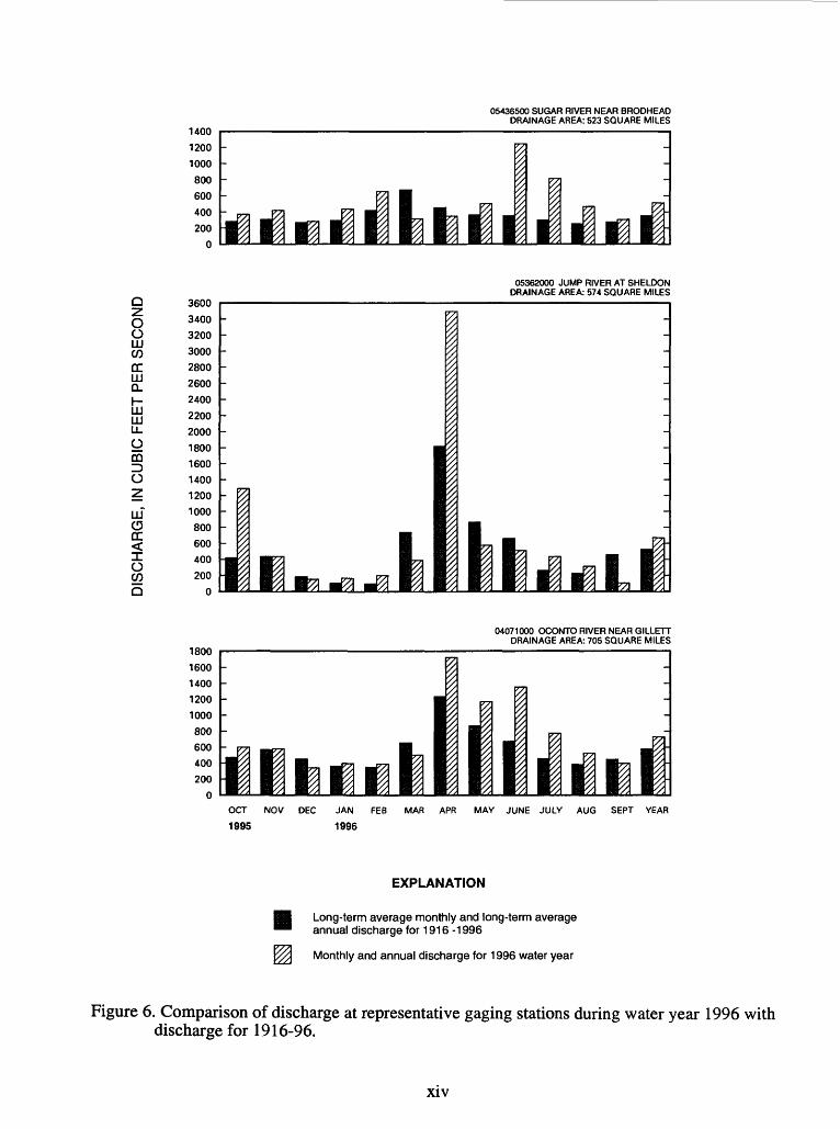
Annual discharges for the individual water years (1916-96) at the Oconto River near Gillett, Jump River at Sheldon, and Sugar River near Brodhead are shown in Figure 5. The comparison of monthly and annual discharges for the 1996 water year to discharge for a 81-year base period at the same three gaging stations are shown in Figure 6.
Xll

05436500 SUGAR RIVER NEAR BRODHEAD800
600
400
200
0
Long-term average discharge- u.i
1900 1910 1920 1930 1940 1950 1960 1970 1980 1990 2000
O O LU WCC LU a.
HI HI LLomID O
UJ (3 CC<Ow0
05362000 JUMP RIVER AT SHELDON
1000
800
600
400
200
Long-term iaveragedischargen
1900 1910 1920 1930 1940 1950 1960 1970 1980 1990 2000
04071000 OCONTO RIVER NEAR GILLETT1200
1000
800
600
400
200
0
Long-termaveragedischargewr.9!llloi
1900 1910 1920 1930 1940 1950 1960
WATER YEAR
1970 1980 1990 2000
Figure 5. Comparison of annual discharge at representative gaging stations to the long-term average discharge for water years 1916-96.
Xlll
05436500 SUGAR RIVER NEAR BRODHEAD DRAINAGE AREA: 523 SQUARE MILES
Q
O O LJJ CO
DC LJJ QLI- LJJ LJJ U_
OCQID O
LJJ C3 DC < I O COQ
05362000 JUMP RIVER AT SHELDON DRAINAGE AREA: 574 SQUARE MILES
3600
3400
3200
3000
2800
2600
2400
2200
2000
1800
1600
1400
1200
1000
800
600
400
200
0
1800
1600
1400
1200
1000
800
600
400
200
04071000 OCONTO RIVER NEAR GILLETT DRAINAGE AREA: 705 SQUARE MILES
OCT NOV DEC
1995
JAN FEB
1996
MAR APR MAY JUNE JULY AUG SEPT YEAR
EXPLANATION
Long-term average monthly and long-term average annual discharge for 1916 -1996
Monthly and annual discharge for 1996 water year
Figure 6. Comparison of discharge at representative gaging stations during water year 1996 with discharge for 1916-96.
xiv

Low flows occurred at nine gaging stations where the annual minimum 7-consecutive day average flows (Q7) had recurrence intervals of 2 or more years. The Q7 values typically occurred in late August and September, or in the winter month of January. The low-flow values which occurred in the summer were the result of below normal precipitation in August and September. Most Q7 values occurred at stations draining into Lake Michigan in southeastern Wisconsin. The Q7 values and recurrence intervals for gaging stations that equalled or exceeded 2 years are listed in the following table:
Station number
04027500
040852810408703004087120
0408715904087204
04087220
04087233
04087240
Station name
White River near Ashland
East Twin River at MishicotMenomonee River at Menomonee FallsMenomonee River at Wauwatosa
Kinnickinnic River at MilwaukeeOak Creek at South Milwaukee
Root River near Franklin
Root River Canal near Franklin
Root River at Racine
Date
Sept. 17-23
Sept. 2-9Sept. 13-19Sept. 14-20
Jan. 5-11Sept. 14-20
Sept. 13-19Aug. 31-Sept.6
Sept. 19-25
Q7 (ft3/s)
134
9.63.5
13
4.21.02.7
1.7
2.1
Recurrence interval (years)
5
22
2
64
4
310
A late snowpack along with a late sudden warm-up and some rain caused flooding in northern Wisconsin in mid to late April (Wisconsin State Journal, April 22, 1996). Isolated storms in October and May and major thunderstorms in June and July also caused floods with discharges that equalled or exceeded those with a recurrence interval of 10 years (Krug and others, 1991). During the three-day period of June 16-18, Port Washington in Ozaukee County received 13.52 inches of rain and had a monthly June total of 18.33 inches which was 60 percent of its average yearly total for the period from 1961-90 (State Climatologist office, UW-Extension, Geological and Natural History Survey, written commun., 1996). The thunderstorms in June caused statewide damages of $67 million to public property, private property, and agricultural crops (Kapela and others, 1996). Governor Thompson asked for federal assistance to help repair flood damage in 15 counties caused by the June storms (Wisconsin State Journal, June 20,1996). A major storm dumped 8 to 11 inches of precipitation in a 5-hour period on July 17 and 18 in Green County (Wisconsin State Journal, July 19,1996). Public and private damages in Green County from this storm was about $60 million with as much as $50 million of this amount in crop damages (Wisconsin State Journal, July 20, 1996). Peak discharges at 26 stations which had recurrence intervals that equalled or exceed 10 years are summarized in the following table:
Station number
0402700004027500
04063700
0406600304067760
04069700040718000407340004074850
Station name
Bad River near OdanahWhite River near Ashland
Popple River near FenceMenominee River near PembinePeshtigo River near Cavour
North Branch Oconto River near WabenoPensaukee River near PulaskiBird Creek at WautomaLily River near Lily
Date
Apr. 20Apr. 19
Apr. 26
Apr. 27Apr. 21
Apr. 20June 18June 18Apr. 20
Peak discharge (ft3/s)
13,0004,930
1,490
22,4001,600
621
1,810141167
Recurrence interval (years)
1011
481232
>100
251315
XV

Station number
0407495004077400
04078500
04079700
04084500
04087030
04087257
05332500
05359600053605000539195005393500
053936400539500005425500
05429500
05430175
Station name
Wolf River at Langlade
Wolf River near Shawano
Embarrass River near Embarrass
Spaulding Creek near Big Falls
Fox River at Rapide Croche Dam nr Wrightstown
Menomonee River at Menomonee FallsPike River near Racine
Namekagon River near Trego
Price Creek near Phillips
Flambeau River near BruceSquaw Creek near HarrisonSpirit River at Spirit FallsLittle Pine Creek near Irma
Wisconsin River at MerrillRock River at Watertown
Yahara River at McFarlandYahara River near Fulton
Date
Apr. 26
Apr. 21
June 19
June 18
June 26
June 17May 20
Apr. 22
Apr. 20Apr. 20
Oct. 23Apr. 20Apr. 19Apr. 21
June 18
June 19June 18
Peak discharge (ft3/s)
2,440
3,860
4,830
93
14,600
1,1001,360
2,160
328
17,90034
3,130210
23,400
3,790
7783,230
Recurrence interval (years)
75
17
75
32
14
17
1015
48
142520
1015
119042
References cited:
Kapela, Rusty, and others, 1996, Wisconsin's Weather Can't Get Any Wilder, in The Wisconsin National Weather Service Badger Weather Report: v. 4, no. 2, p.8-9.
Krug, W.R., Conger, D.H., and Gebert, W.A., 1991, Flood-Frequency Characteristics of Wisconsin Streams: U.S. Geological Survey Water-Resources Investigations Report 91-4128, 185 p.
Wisconsin State Journal, Bad River overflows, closing part of highway: Madison, Wis., April 22, 1996.
_____________, Fed asked for flood money: Madison, Wis., June 20, 1996.
_____________, 11 inches of rain falls in 5 hours: Madison, Wis., July 19,1996.
_____________, Green County rained out: Madison, Wis., July 20, 1996.
Water Quality
Suspended-sediment and total phosphorus yields for streams in southern Wisconsin for water year 1996 were generally lower than the long-term annual average. The suspended-sediment yield at the Grant River at Burton in southwestern Wisconsin was 80 tons/mi2 (tons per square mile), or 33 percent of the average annual yield for 1978-96. The suspended-sediment yield for Jackson Creek Tributary near Elkhorn in southeastern Wisconsin for water year 1996 was 101 tons/mi2, which was 139 percent of the average annual yield for the period 1984-96. The total phosphorus yield for Jackson Creek Tributary was 398 Ibs/mi2 (pounds per square mile), or 85 percent of the 1984-96 annual average. At Silver Creek near Ripon suspended sediment yield was 18.8 tons/mi2, or 80 percent of the 1988-96 annual average, and total phosphorus yield was 306 Ibs/mi2, or 88 percent of the 1988-96 annual average.
xvi
Ground-Water Levels
Maps showing the seasonal ground-water trends for the year (fig. 4) are based on water-level data from 23 shallow-aquifer wells, each having at least 15 years of record. Water-level measurements from each well are grouped so that FALL consists of measurements from October through December 1995; WINTER consists of measurements from January through March 1996; SPRING consists of measurements from April through June 1996; and SUMMER consists of measurements from July through September 1996. Mean seasonal water levels were compared to the long-term mean seasonal water levels. The 1996 water level was considered normal if it was within one-half of the standard deviation on the long-term mean.
In general, shallow ground-water levels during the 1996 water year were normal to above normal for most of the wells in the State. Barron and Milwaukee Counties had below normal ground-water levels at the beginning of the water year, and some of those levels remained below normal for the entire water year. The large extent of normal and above-normal ground-water levels can be attributed to near normal rainfall during the 1996 water year and above normal rainfall during the previous water year.
xvn

FALLOCT-DEC 1995
SPRINGAPR-JUNE 1996
EXPLANATION
WATER-TABLE LEVELS
Above normal Water levels more than one-half standard deviation above the long-term mean
Normal Water levels within one-half standard deviation of the long-term mean
Below normal Water levels more than one-half standard deviation below the long-term mean
OBSERVATION WELL
WINTERJAN-MAR 1996
SUMMERJULY-SEPT 1996
Figure 7. Relation of seasonal water-table levels to long-term means.
xvm

COLLECTION OF BASIC RECORDS-SURFACE WATER, Wl 001
COOPERATORS:Wisconsin Department of Natural ResourcesU.S. Army Corps of EngineersSoutheastern Wisconsin Regional Planning CommissionFederal (Regular)Madison Metropolitan Sewerage DistrictDane County Department of Public WorksFederal Energy Regulatory Commission Licensees
Dairyland Power CooperativeNiagara of Wisconsin Paper CorporationNorthern States Power CompanyWisconsin Electric Power CompanyWisconsin Power and Light CompanyWisconsin Public Service CorporationWisconsin Valley Improvement Company
Lac du Flambeau Band of Lake Superior Chippewa Dlinois Department of Transportation City of Barron City of Beaver Dam CityofBrookfield CityofHillsboro City of Peshtigo City of River Falls City of Sparta City of Thorp City ofWaupun Village of WittenbergFontana/Walworth Water Pollution Control Commission Rock County Public Works Department Menominee Indian Tribe of Wisconsin Oneida Tribe of Indians of Wisconsin Stockbridge-Munsee Band of Mohican Indians Walworth County Metropolitan Sewerage District Bad River Band of Lake Superior Chippewa Indians
PROBLEM: Surface-water information is needed for surveil lance, planning, design, hazard warning, operation, and manage ment in water-related fields such as water supply, hydroelectric power, flood control, irrigation, bridge and culvert design, wildlife management, pollution abatement, flood-plain management, and water-resources development. An appropriate data base is necessary to provide this information.
OBJECTIVE: The objectives of this study are to provide con tinuous discharge records for selected rivers at specific sites to
LOCATION:Statewide
PROJECT CHIEF:Barry K. Holmstrom
PERIOD OF PROJECT:July 1913-Continuing

supply the needs for regulation, analytical studies, defi nition of statistical properties, trends analysis, determi nation of the occurrence, and distribution of water in streams for planning. The project is also designed to de termine lake levels and to provide discharge for floods, low-flow conditions, and for water-quality investiga tions. Requests for streamflow data and information re lating to streamflow in Wisconsin are answered. Basic data are published annually in the report "Water Resources Data-Wisconsin".
APPROACH: A network of streamflow stations and lake-level stations will be maintained throughout Wis consin. This includes operating the equipment at the gag ing station to record river or lake stage, making periodic discharge measurements at each streamflow station to establish or verify a stage-discharge rating curve, reduc ing the stage records to instantaneous and daily discharg es, compilation of monthly and annual discharges, and preparing data for publication in the annual report "Water Resources Data-Wisconsin".
Requests for streamflow data from other government agencies, consultants, and private parties will be processed.
PROGRESS (July 1996 to June 1997): During the current fiscal year, streamflow data were collected at a total of 92 sites: 27 sites for the Wisconsin Department of Natural Resources (WDNR), 17 sites for the Corps of Engineers, 14 sites for the Southeastern Wisconsin Re gional Planning Commission, 6 sites for the Federal pro gram, 3 sites for the Madison Metropolitan Sewerage District, and 1 site each for the Bad River Band of Lake Superior Chippewa Indians, Lac du Flambeau Band of Lake Superior Chippewa, Menominee Indian Tribe of Wisconsin, Oneida Tribe of Indians of Wisconsin, Stockbridge-Munsee Band of Mohican Indians, Illinois Department of Transportation, Rock County, Fontana/ Walworth Water Pollution Control Commission, Dane County Department of Public Works, Walworth County Metropolitan Sewerage District, Federal Energy Com mission Licensee, and cities of Barron, Beaver Dam, Brookfield, Hillsboro, Peshtigo, Sparta, Thorp, Waupun, and village of Wittenberg. Streamflow data were also collected at four sites for agencies working jointly with the USGS. Lake-level data were collected at two sites for the Dane County Department of Public Works, at two sites for the Corps of Engineers, at one site for the Rock County Public Works Department, and one site for the WDNR.
A map showing the locations of all continuous-record streamflow-gaging stations in Wisconsin is shown on page 5.
Computation of streamflow and lake-level records for all the network stations for the 1996 water year was
completed, stored in our WATSTORE computer data base, and published in the annual report "Water Resources Data-Wisconsin, water year 1996". More than 100 requests for streamflow information were answered.
PLANS (July 1997 to June 1998): Data will be collected at 92 continuous-streamflow stations (see the following list) and lake levels at 6 stations. Streamflow records will be computed and data published for the 1997 water year. Requests for streamflow information will be answered.
Due to budget constraints by the WDNR, operation of the following stations was discontinued as of July 1, 1996.
04071858 Pensaukee River near Pensaukee 04085200 Kewaunee River near Kewaunee 04085281 East Twin River at Mishicot 04085427 Manitowoc River at Manitowoc
Real-time data can be accessed on World-Wide Web at http://wwwdwimdn.er.usgs.gov
Water Resources Investigations in Wisconsin, 1997

SURFACE-WATER GAGING STATIONS EXPECTED TO BE OPERATED IN 1998 FY
Station number
040244300402550004027000
0402750004029990
0406370004064500040651060406600304069500
0407100004072150040735000407495004077400
04077630
0407809265040790000408240004084445
040645000406600004066500
0408660004087000
0408703004087088040871200408716004067204
0406722004087233040872400408725705332500
0534050005341500053560000535650005357335
05360500053620000536550005365707053674464
0536800005369000053695000537000005379500
0538200005382325053910000539350005394500
Name and location
Nemadji River - South SuperiorBois Brule River - BruleBad River - Odanah
White River AshlandMontreal River - Saxon Falls
Popple River - FencePine River - Pine River Powerplant - FlorenceMenominee River - NiagaraMenominee River - PembinePeshtigo River - Peshtigo
Oconto River - GillettDuck Creek - HowardFox River - BerlinWolf River - LangladeWolf River - Shawano
Red River - Morgan
Middle Branch Embarrass River - WittenbergWolf River - New LondonFox River - OshkoshFox River - Appleton
Fox River - Rapide Croche Dam - WrightstownSheboygan River - SheboyganCedar Creek - Cedarburg
Milwaukee River - Pioneer Road - CedarburgMilwaukee River - Milwaukee
Menomonee River - Menomonee FallsUnderwood Creek - WauwatosaMenomonee River - WauwatosaKinnickinnic River - MilwaukeeOak Creek - South Milwaukee
Root River - FranklinRoot River Canal FranklinRoot River - RacinePike River - RacineNamekagon River - Trego
St. Croix River St. Croix FallsApple River - SomersetChippewa River - WinterChippewa River - BruceBear River - Manitowish Waters
Flambeau River - BruceJump River - SheldonChippewa River - Chippewa FallsNorth Fork Eau Claire River - ThorpYellow River - Barron
Hay River - WheelerRed Cedar River - MenomonieChippewa River - DurandEau Galle River - Spring ValleyTrempealeau River - Dodge
Black River - GalesvilleLa Crosse River - SpartaWisconsin River - Lake TomahawkSpirit River - Spirit FallsPrairie River - Merrill
Drainage Area
420118597
301262
139533
247031401080
705108
1340463816
114
76.3226053105950
6010418120
607696
34.718.2
12320.425
49.257
19038.5
488
6240579790
165081.3
1860576
565051
153
41817709010
64.1643
2080167757
81.6184
Period of record (water year)
1974-1943-81, 1984-1914-22, 1948-
1948-1987
1964-1924-76, 1996-1993-1950-1953-
1906-09, 1914-1988-1898-1966-79, 1981-1907-09, 1911-
1993
1990-1896-19911986-
1896-1916-24, 1951-1930-70,73-81,1983-87, 1991 -1982-1914-
1975-77, 1979-1975-1962-1976-1964-
1964-1964-1963-1972-1928-70, 1988
1902-1901-70, 19871912-1914-1991
1951-1915-1888-1983, 198719861991
1951-1907-08, 1913-1928-1944-1914-19, 1934
1932-1992-1936-1942-1914-31, 1939
Cooperator
WDNRFed.Bad River Band of Lake
Superior Chippewa IndiansWDNRWDNR
Fed.WDNRFERCWDNRCity of Peshtigo
Fed.Oneida Tribe of Indians of WlC of E, DetroitMenominee Indian Tribe of WlWDNR
Stockbridge-Munsee Band ofMohican Indians
Village of WittenbergC of E, DetroitWDNRC of E, Detroit
WDNRWDNRWDNR
SEWRPCSEWRPC
SEWRPCSEWRPCSEWRPCSEWRPCSEWRPC
SEWRPCSEWRPCSEWRPCSEWRPCWDNR
WDNRWDNRWDNRWDNRLac du Flambeau Band of Lake
Superior Chippewa
WDNR, FERCFed.WDNRCity of ThorpCity of Barron
Fed.WDNRC of E, St. PaulC of E, St. PaulC of E, St. Paul
C of E, St. Paul, WDNRCity of SpartaWDNRWDNRWDNR

SURFACE-WATER GAGING STATIONS EXPECTED TO BE OPERATED IN 1998 FY
Station number
0539500005397500053980000539950005400760
0540200005404000054041160540500005406500
0540700005406000054104900541350005414000
0542350005425500054259120542600005426250
0542757005429500054301500543017505430500
0543103205431486
054325000543300005434500
05435943054365000543828305543800055438300554420005545750
040825000408425505404500
054272350542800005429000
Name and location
Wisconsin River - MerrillEau Claire River - KellWisconsin River - RothschildBig Eau Pleine River StratfordWisconsin River - Wisconsin Rapids
Yellow River BabcockWisconsin River - Wisconsin DellsS. Br. Baraboo River - HillsboroBaraboo River - BarabooBlack Earth Creek - Black Earth
Wisconsin River - MuscodaKickapoo River - LaFargeKickapoo River - SteubenGrant River BurtonPlatte River - Rockville
S. Br. Rock River - WaupunRock River - WatertownBeaverdam River - Beaver DamCrawfish River - MilfordBark River - Rome
Rock River - IndianfordYahara River - McFartandBadfish Creek - CooksvilleYahara River - FultonRock River - Afton
Turtle Creek - DelavanTurtle Creek Clinton
Pecatonica River - DarlingtonE. Br. Pecatonica River - BlanchardvillePecatonica River - Martintown
Badger Mill Creek - VeronaSugar River - BrodheadPiscasaw Creek - WalworthFox River - Watertown Road WaukeshaFox River - WaukeshaMukwonago River - MukwonagoFox River - New Munster
Lake Winnebago - OshkoshLake Winnebago - StockbridgeDevil's Lake - Baraboo
Lake Koshkonong - NewvilleLake Mendota - MadisonLake Monona - Madison
Drainage Period of record Area (water year)
2760375
4020224
5420
2158090
39.1609
45.6
10400266687269142
63.6969157762122
2630327
82.6517
3340
83.3199
273221
1034
20.3523
9.5877.4
12674.1
811
LAKES
58805880
4.79
2560233279
1903-1914-27, 1939-1945-1914-26, 1937-1914-50, 1958-
1944-1935-1988-1914-22, 1943-1954-
1903-04, 1914-1939-1933-1935-1935-
1948-69, 19871931-70, 1977-1984-1931-1980-
1975-1930-1977-19771914-
1996-1939-
1939-1939-1986, 19881940-
1997-1914-1992-1993-1963-1973-1940-
1882-1983-1922-30, 1932,1934-81, 1985-19871903, 1916-1915-
Cooperator
WDNRWDNRWDNRWDNRWDNR
WDNRWDNRCity of HillsboroFed.Dane County
C of E, St. PaulWl Dept. TourismC of E, St. PaulC of E, R. IslandC of E, R. Island
City of WaupunC of E, R. IslandCity of Beaver DamRock County, Jefferson CountySEWRPC
Rock CountyDCDPWMMSDMMSDC of E, R. Island
WALCOMETC of E, Rock Island,WALCOMETC of E, R. IslandC of E, R. IslandC of E, R. Island
MMSDC of E, Rock IslandFontana/Walworth WPCCCity of BrookfieldSEWRPCSEWRPCIL DOT
C of E, DetroitC of E, DetroitWDNR
Rock CountyDCDPWDCDPW
C of E, Detroit - Corps of Engineers, Detroit, MichiganC of E, R. Island - Corps of Engineers, Rock Island, IllinoisC of E, St. Paul - Corps of Engineers, St. Paul, MinnesotaDCDPW - Dane County Department of Public WorksFed. - USGS Federal ProgramFERC - Federal Energy Regulatory Commission LicenseesFontana/Walworth WPCC - Fontana/Walworth Water Pollution Control CommissionIL. DOT - Illinois Department of TransportationMMSD - Madison Metropolitan Sewerage DistrictSEWRPC - Southeastern Wisconsin Regional Planning CommissionWALCOMET - Walworth County Metropolitan Sewerage DistrictWDNR - Wisconsin Department of Natural ResourcesWl Dept. Tourism - Wisconsin Department of Tourism
Water Resources Investigations in Wisconsin, 1997

EXPLANATION05382200 Station Number
A Stream gage, Wl 001 project
A. Stream gage equipped with telephone or data collection platform, Wl 001 project
Stream gage, other project
Stream gage equipped with telephone or data collection platform.other project
Lake Gage
District Office
Field Office
) 408444?
5427718 $425600
5428000
45427570 5544200I " - - - -1
Figure 8. Location of continuous-record data-collection stations.

DISCONTINUED SURFACE-WATER DISCHARGE STATIONS
The following continuous-record surface-water discharge stations in Wisconsin have been discontinued. Daily streamflow records were collected and published for the period of record, expressed in water years, shown for each station. Those stations with an asterisk (*) after the station number are currently operated as crest-stage partial-record stations. Some of the discontinued project stations with less than three years of record have not been included. Infor mation regarding these stations may be obtained from the District Office at the address given on the back side of the title page of this report.
Discontinued surface-water discharge stations
Station nameStation number
Drainage area (square miles)
STREAMS TRIBUTARY TO LAKE SUPERIOR
Little Balsam Creek at Patzau, WlLittle Balsam Creek near Patzau, WlLittle Balsam Creek Tributary near Patzau, WlLittle Balsam Creek near Foxboro, WlAmnteon River near Poplar (Amnicon Falls), WlBois Brule (Brule) River near Brule, WlSioux River near Washbum, WlPine Creek at Moquah, WlPine Creek Tributary at Moquah, WlPine Creek near Moquah, WlNorth Fish Creek near Moquah, WlBad River near Mellen, WlBad River at Mellen, WlAlder Creek near Upson, WlMontreal River near Kimball, WlWest Fork Montreal River at Gile, WlWest Fork Montreal River near Kimball, Wl
0402431404024315 04024318 04024320 04025000 04026000 04026300*04026347040263480402634904026349104026450*0402650004026870040285000402900004029500
4.895.050.603.27
11016033.96.200.48
19.965.482.098.322.210075.086.2
STREAMS TRIBUTARY TO LAKE MICHIGAN
Period of record
1976-78 1976-781976-781977-781914-161914-171965-661976-781976-781976-781990-911971-751948-551972-771924-261918-26, 1943-471924-26
North Branch Pine River at Windsor Dam nr Alvin, WlPine River near Florence, WlPine River below Pine River Power Plant near Florence, WlPike River at Amberg, WlMenominee River near McAllister, Wl
Peshtigo River at High Falls near Crivitz, WlPensaukee River near Pensaukee, WlSuamico River at Suamico, WlLawrence Creek near Westfield, WlGrand River near Kingston, WlWest Branch White River near Wautoma, WlWhite Creek at Forest Glen Beach near Green Lake, WlSwamp Creek above Rice Lake at Mole Lake, WlSwamp Creek below Rice Lake at Mole Lake, WlWolf River near White Lake, WlEvergreen Creek near Langlade, WlWolf River above West Branch Wolf River, WlWest Branch Wolf River at Neopit, WlWest Branch Wolf River near Keshena, WlLittle Wolf River near Galloway, WlSpaulding Creek near Big Falls, WlLittle Wolf River at Royalton, WlEmmons Creek near Rural, WlStorm Sewer to Mirror Lake at Waupaca, WlWaupaca River near Waupaca, WlDaggets Creek at Butte Des Morts, WlWest Branch Fond du Lac River at Fond du Lac, WlEast Branch Fond du Lac River near Fond du Lac, WlBrothertown Creek at Brothertown, WlKewaunee River near Kewaunee, WlEast Twin River at Mishicot, WlManitowoc River at Manitowoc, WlOnion River at Hingham, WlOnion River near Sheboygan Falls, WlMilwaukee River at Kewaskum, WlEast Branch Milwaukee River near New Fane, Wl
04063640*04064000040645000406650004067500
0406800004071858040720000407275004073050040734050407346204074538040745480407500004075200*0407550004076000040765000407960204079700*040800000408095004060976040810000406180004083000040835000408420004085200040852810408542704085813040858450408615004086200
27.8510533255
3,930
53713460.713.473.538.9
3.0546.356.8
4858.09
61693.2
16322.6
5.57507
25.10.04
26510.683.178.4
5.10127110526
37.294.1
13854.1
1967-681914-231924-761914-701945-61, 1979-86,1988-90, 1993-951912-571973-961951-521968-731968-751964-751982-881977-83, 1985-871977-79, 1982-851935-381964-731928-621911-171928-321974-791964-661914-70, 1983-8519771971-741916-66, 1983-8519771939-541939-541976-771964-961972-961972-961979-801979-821968-811968-81
Water Resources Investigations in Wisconsin, 1997

Discontinued surface-water discharge stations
Station nameStation number
Drainage area (square miles) Period of record
North Branch Milwaukee River near Fillmore, Wl 04086340Milwaukee River at Waubeka, Wl 04086360Mud Lake Outlet near Decker Comer, Wl 04086488 Milwaukee River above North Ave. Dam at Milwaukee, Wl 04087010Menomonee River at Germantown, Wl 04087018Jefferson Park Drainageway at Germantown, Wl 04087019Menomonee River at Butler, Wl 04087040Little Menomonee River near Freistadt, Wl 04087050*Noyes Creek at Milwaukee, Wl 04087060Little Menomonee River at Milwaukee, Wl 04087070Honey Creek at Wauwatosa, Wl 04087119Schoonmaker Creek at Wauwatosa, Wl 04087125Hawley Road Storm Sewer at Milwaukee, Wl 04087130Menomonee River at Milwaukee, Wl 04087138Kinnickinnic River at Milwaukee, Wl 04087160
Namekagon River at Trego, Wl Loon Creek near Danbury, Wl Bashaw Brook near Shell Lake, Wl Clam River near Webster, Wl St. Croix River near Grantsburg, Wl Wood River near Grantsburg, Wl Rice Creek near Balsam Lake, Wl Balsam Branch at Balsam Lake, Wl Kinnickinnic River near River Falls, Wl
ST. CROIX RIVER BASIN
053320000533501005335380*053355000533600005339000053413750534140205342000
CHIPPEWA RIVER BASIN
West Fork Chippewa River at Lessards, nr Winter, Wl 05355500Couderay River near Couderay, Wl 05356121 Flambeau River at Flambeau Flowage (Flambeau Reservoir), Wl 05357500Flambeau River near Butternut, Wl 05358000Pine Creek near Oxbo, Wl 05358300 Flambeau River at Babbs Island near Winter, Wl 05358500South Fork Flambeau River near Phillips, Wl 05359500Price Creek near Phillips, Wl 05359600*Flambeau River near (at) Ladysmith, Wl 05360000Chippewa River near Holcombe, Wl 05361000South Fork Jump River near Ogema, Wl 05361500Chippewa River at Holcombe, Wl 05362500Fisher River at (near) Holcombe, Wl 05363000O'Neil Creek near Chippewa Falls, Wl 05363500Yellow River near Hannibal, Wl 05363700Yellow River at Cadott, Wl 05364000*Duncan Creek at Bloomer, Wl 05364500*Duncan Creek Tributary near Tilden, Wl 05364850Duncan Creek at Chippewa Falls, Wl 05365000Eau Claire River near Augusta, Wl 05366000Bridge Creek at Augusta, Wl 05366300Eau Claire River near Fall Creek, Wl 05366500*Chippewa River at (near) Eau Claire, Wl 05367000Red Cedar River near Cameron, Wl 05387425Red Cedar River near Cameron, Wl 05367426Red Cedar River near Colfax, Wl 05387500Eau Galle River near Woodville, Wl 05369900 Eau Galle River at low water bridge at Spring Valley, Wl 05369945French Creek near Spring Valley, Wl 05369955Lousy Creek near Spring Valley, Wl 05369970Lohn Creek near Spring Valley, Wl 05369985Eau Galle River at Elmwood, Wl 05370500
BUFFALO RIVER BASIN
148 432
7.36 702 19.01.82
60.6 8.0 1.94
I 9.7 10.3 1.94 1.83
134 20.4
43317.626.6
3612,98018512.552.8165
47416962268838.996760916.9
1,7903,720327
4,68081.578.186.736450.34.17
11750935.0760
6,620442443
1,10039.447.96.035.972.53
91.6
1968-81 1968-81, 1994 1983-84 1982-841975-771976-781975-791975-791975-80, 19901975-771975-811975-791975-771982-841976-83
1914-27 1970-71 1964-66 1941-42 1923-70 1939-40 1988-89 1988-90 1917-21
1912-161981-831927-611914-391971-751929-751929-751964-661903-06, 1914-611944-491944-541943-491944-45 1944-45 1962-631943-611944-521987-891943-551914-2619601943-551903-09, 1944-541966-701971-731914-80, 1989-901978-831982-83, 1986-961981-831981-831981-831943-54
Buffalo River near Tell, Wl 05372000 406 1933-51

Discontinued surface-water discharge stations
Station nameStation number
Drainage area (square miles) Period of record
Brace Valley Creek near Pleasantville, Wl Elk Creek near Independence, Wl Trempealeau River at Arcadia, Wl Trempealeau River near Trempealeau, Wl
Black River at Medford, Wl Poplar River near Owen, Wl
Little LaCrosse River near Leon, Wl LaCrosse River near West Salem, Wl
Spring Coulee Creek near Coon Valley, Wl Coon Creek at Coon Valley, Wl Coon Creek near Stoddard, Wl
North Fork Bad Axe River near Genoa, Wl
TREMPEALEAU RIVER BASIN
05379288 10.105379305 10805379400 55305380000 719
BLACK RIVER BASIN
05380806 48.1 05380900* 155
LA CROSSE RIVER BASIN
05382500 76.905383000 396
COON CREEK BASIN
05386490 9.0105386500 77.205386999 120
BAD AXE RIVER BASIN
05387100* 80.8
WISCONSIN RIVER BASIN
1980 1980 1960-77 1932-34
1984-87 1964-66
1934-61, 1979-81 1914-70
1979-811934-40, 1978-81 1934-40, 1979-81
1964-66
Wisconsin River at Conover, WlPelican River near Rhinelander, WlWisconsin River at Whirlpool Rapids, near Rhinelander, WlBearskin Creek near Harshaw, WlTomahawk River near Bradley, WlTomahawk River at Bradley, WlNew Wood River near Merrill, WlRib River at Rib Falls, WlLittle Rib River near Wausau, WlEast Branch Eau Claire River near Antigo, WlEau Claire River near Antigo, WlBull Junior Creek (Bull Creek Junior) near Rothschild, WlBig Eau Pleine River near Colby, WlHamann Creek near Stratford, WlWisconsin River at Knowlton, WlPlover River near Stevens Point, WlLittle Plover River near Amott, WlLittle Plover River at Plover, WlFourmile Creek near Kellner, WlBuena Vista Creek near Kellner, WlTenmile Creek Ditch 5 near Bancroft, WlFourteenmile Creek near New Rome, WlWisconsin River near Necedah, WlBig Roche a Cri Creek near Hancock, WlBig Roche a Cri Creek near Adams, WlYellow River at Sprague, WlYellow River at Necedah, WlLemonweir River at New Lisbon, WlHulbert Creek near Wisconsin Dells, WlDell Creek near Lake Delton, WlNarrows Creek at Loganville, WlWisconsin River at Prairie du Sac, Wl
05390180053912260539200005392350*05392400053930000539400005396000053965000539700005397110053985000539900005399431054000000540050005400600054006500540084005400853054010200540110005401500054015100540153505402500054030000540350005403630*05403700*05404200*05406000
Trout Creek at Confluence with Ameson Creek nr Barneveld, Wl 05406573Trout Creek at Twin Parks Dam 8 nr Barneveld, WlTrout Creek at County Highway T nr Barneveld, WlTrout Creek near Ridgeway, WlKnight Hollow Creek near Arena, WlOtter Creek near Highland, WlKickapoo River at Ontario, WlKnapp Creek near Bloomingdale, WlWest Fork Kickapoo River near Readstown, WlKickapoo River at Soldiers Grove, WlNorth Fork Nederlo Creek near Gays Mills, WlNederlo Creek near Gays Mills, WlKickapoo River at Gays Mills, Wl
054065740540657505406577054065900540664005407500054085000540900005409500054098300540989005410000
177101
1,22031.1
422544
82.2303
79.181.5
18527.478.111.3
4,530145
2.2419.075.053.19.73
91.15,990
9.6152.8
392491507
11.244.940.1
9,1808.379.02
12.113.57.57
16.8151
8.44106530
2.219.46
617
1967-711976-791906-611964-661915-27, 19291930-731953-611925-571914-161949-551975-811944-521941-541977-791921-421914-20, 1944-521959-751959-871964-671964-671964-731964-791903-14, 1944-501964-671964-781927-401941-571944-87, 19941971-771957-65, 1971-801964-661946-541976-781976-791976-781976-791976-781968-69, 1970-751939, 1973-771955-69193919391968-791968-801914-34, 1964-77
Water Resources Investigations in Wisconsin, 1997

Discontinued surface-water discharge stations
Station nameStation number
Drainage area (square miles) Period of record
Pigeon Creek near Lancaster, WlRattlesnake Creek near Beetown, Wl
Little Platte River near Platteville, Wl Sinsinawa River near Hazel Green, Wl Pats Creek near Belmont, Wl Madden Branch Tributary near Belmont, Wl Madden Branch near Meekers Grove, Wl Galena River at Buncombe, Wl
Apple River near Shullsburg, Wl
GRANT RIVER BASIN
05413400*05413451
GALENA RIVER BASIN
05414213054148000541489405414915*0541492005415000
APPLE RIVER BASIN
05418731
ROCK RIVER BASIN
West Branch Rock River near Waupun, Wl 05423000West Branch Rock River at County Trunk Highway D 05423100
near Waupun, WlEast Branch Rock River near Mayville, Wl 05424000Rock River at Hustisford, Wl 05424082Johnson Creek near Johnson Creek, Wl 05425537Johnson Creek near Johnson Creek, Wl 05425539Pratt Creek near Juneau, Wl 05425928Rock River at Jefferson, Wl 05426031Whitewater Creek near Whitewater, Wl 05426500Whitewater Creek at Millis Road near Whitewater, Wl 05426900Whitewater Creek at Whitewater, Wl 05427000Koshkonong Creek near Rockdale, Wl 05427507Token Creek near Madison, Wl 05427800*Sixmile Creek near Waunakee, Wl 05427900Pheasant Branch at Airport Road near Middleton, Wl 05427943 South Fork Pheasant Branch at Highway 14 near Middleton, Wl 05427945Pheasant Branch at Century Avenue at Middleton, Wl 05427950Pheasant Branch at mouth at Middleton, Wl 05427952Willow Creek at Madison, Wl 05427970Olbrich Park Storm Ditch at Madison, Wl 05428665Manitou Way Storm Sewer at Madison, Wl 05429040Nakoma Storm Sewer at Madison, Wl 05429050Lake Wingra Outlet at Madison, Wl 05429120Door Creek near Cottage Grove, Wl 05429580Yahara River near Edgerton, Wl 05430000Oregon Branch at Oregon, Wl 05430030Badfish Creek at County Highway A near Stoughton, Wl 05430095Badfish Creek near Stoughton, Wl 05430100Jackson Creek at Petrie Road near Elkhorn, Wl 05431014Livingston Branch, Pecatonica River near Livingston, Wl 05432055Yellow/stone River near Blanchardville, Wl 05433500*Pecatonica River at Dill, Wl 05434000Steiner Branch near Waldwick, Wl 05433510Skinner Creek at Skinner Hollow Road near Monroe, Wl 05434235Skinner Creek at Klondyke Road near Monroe, Wl 05434240West Branch Sugar River near Mount Vemon, Wl 05435980Mount Vemon Creek near Mount Vemon, Wl 05436000
ILLINOIS RIVER BASIN
6.9345.2
79.724.9
5.422.83
15.04125
9.34
40.743.9
179511
1.1313.33.54
1,85011.820.622.8
15024.341.1
9.615.74
20.824.5
3.152.570.232.306.00
15.3430
9.9341.941.3
8.9616.428.5
9445.9
32.635.032.716.4
1964-661990-91
1987-90 1987-90 1981-82 1981-82 1981-82 1939-92
1981-82
1949-70, 1978-81 1978-81
1949-70 1978-85 1978-80 1978-80 1978-80 1978-94 1926-28, 1978-81 1926-28, 1977-82 1964-66,1976-821977-811978-811977-811978-81 1974-83 1976-801971-771972-771971-771976-791917-181979-811956-66,1956-661984-951987-911954-65,1914-191978-791978-811978-811979-80 1954-65,
1946-54
1946-54
1976-81
1986-88
1978-79
1976-80
White River near Burlington, Wl 05545300 110 1964-66, 1973-78

COLLECTION OF BASIC RECORDS-GROUND WATER, Wl 002
COOPERATOR:Wisconsin Geological and Natural
History Survey
LOCATION:Statewide
PROJECT CHIEF:Bernard R. Ellefson
PERIOD OF PROJECT:July 1946-Continuing
PROBLEM: Ground-water data are needed to determine short- term changes and long-term trends in ground-water levels in the State. It is important to know if these changes are natural or man-in duced and how these changes are effecting storage in the ground- water reservoirs.
OBJECTIVE: The objective is to maintain records of ground- water levels from a network of observation wells representative of Wisconsin's principal aquifers.
APPROACH: A basic network of about 155 wells is being maintained. The network will be constantly modified and improved to provide the best possible coverage of our ground-water resource. A subnetwork of key wells is included in this network. Key wells have long periods of record and are measured weekly or are equipped with continuous recorders.
PROGRESS (July 1996 to June 1997): A report of findings from the slug tests and geophysical logging of selected wells in the network was prepared. All water-level and hydrograph data were put on the INTERNET (wwwdwimdn.er.usgs.gov). Funding levels were reduced by the cooperator so data collection at some wells had to be discontinued. Data for the annual report, "Water Resources Data- Wisconsin, water year 1996", was completed.
PLANS (July 1997 to June 1998): Plans include: (1) Contin ue measurements on observation-well network, (2) replace and hire new observers and make quality-assurance checks when possible,(3) slug test and geophysical log 20 wells in the network, and(4) attempt to find additional funding or alternate data-collection methods so data collection at discontinued wells can be resumed.
REPORTS:Patterson, G.L., and Zaporozec, A., 1988, Analysis of water-level
fluctuations in Wisconsin wells: Wisconsin Geological and Natural History Survey Information Circular 63.
Erickson, R.M., and Cotter, R.D., 1983, Trends in ground-water levels in Wisconsin through 1981: Wisconsin Geological and Natural History Survey Information Circular No. 43.
Erickson, R.M., 1972, Trends in ground-water levels in Wisconsin, 1967-71: Wisconsin Geological and Natural History Survey Information Circular No. 21.
Devaul, R.W., 1967, Trends in ground-water levels in Wisconsin through 1966: Wisconsin Geological and Natural History Survey Information Circular No. 9.
10 Water Resources Investigations in Wisconsin, 1997

EXPLANATION
WATER-LEVELMEASUREMENT
FREQUENCY
Y = Annually Q = Quarterly M = Monthly W = Weekly C = Continuous
Figure 9. Location of network observation wells.
11
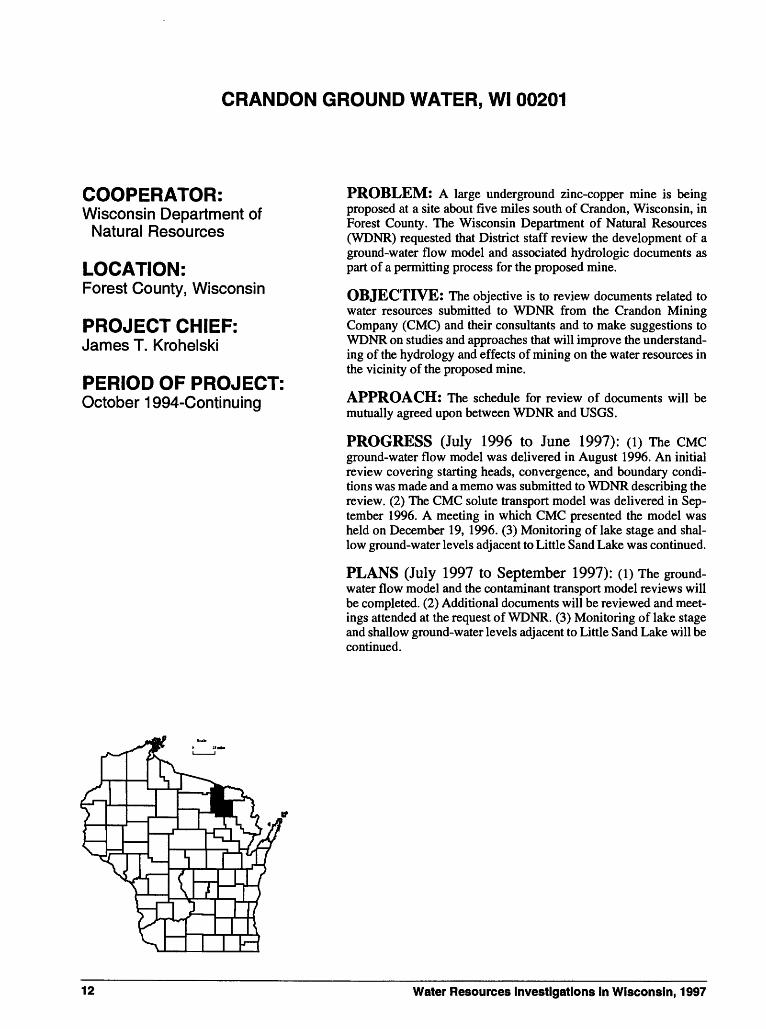
CRANDON GROUND WATER, Wl 00201
COOPERATOR:Wisconsin Department of
Natural Resources
LOCATION:Forest County, Wisconsin
PROJECT CHIEF:James T. Krohelski
PERIOD OF PROJECT:October 1994-Continuing
PROBLEM: A large underground zinc-copper mine is being proposed at a site about five miles south of Crandon, Wisconsin, in Forest County. The Wisconsin Department of Natural Resources (WDNR) requested that District staff review the development of a ground-water flow model and associated hydrologic documents as part of a permitting process for the proposed mine.
OBJECTIVE: The objective is to review documents related to water resources submitted to WDNR from the Crandon Mining Company (CMC) and their consultants and to make suggestions to WDNR on studies and approaches that will improve the understand ing of the hydrology and effects of mining on the water resources in the vicinity of the proposed mine.
APPROACH: The schedule for review of documents will be mutually agreed upon between WDNR and USGS.
PROGRESS (July 1996 to June 1997): (1) The CMC ground-water flow model was delivered in August 1996. An initial review covering starting heads, convergence, and boundary condi tions was made and a memo was submitted to WDNR describing the review. (2) The CMC solute transport model was delivered in Sep tember 1996. A meeting in which CMC presented the model was held on December 19, 1996. (3) Monitoring of lake stage and shal low ground-water levels adjacent to Little Sand Lake was continued.
PLANS (July 1997 to September 1997): (1) The ground- water flow model and the contaminant transport model reviews will be completed. (2) Additional documents will be reviewed and meet ings attended at the request of WDNR. (3) Monitoring of lake stage and shallow ground-water levels adjacent to Little Sand Lake will be continued.
12 Water Resources Investigations in Wisconsin, 1997

BROWNFIELDS, Wl 00203
PROBLEM: The Wisconsin Department of Natural Resources has initiated a land recycling program. This program encourages the redevelopment and return to productive use of urban contaminated properties.
OBJECTIVES: The objective is to give field support to the Wisconsin Department of Natural Resources in determining the extent of contamination of urban contaminated properties.
APROACH: Support will be given by collecting soil and ground-water samples with a Geoprobe and/or analyzing the samples with a field gas chromatograph.
PROGRESS (July 1996 to June 1997): Soil and ground- water samples in the vicinity of several urban contaminated sites were collected and analyzed.
PLANS (July 1997 to June 1998): Support will continue at the request of the Wisconsin Department of Natural Resources.
COOPERATOR:Wisconsin Department of
Natural Resources
LOCATION:Statewide
PROJECT CHIEF:John R DeWild
PERIOD OF PROJECT:May 1996-Continuing
13

COLLECTION OF BASIC RECORDS-WATER QUALITY, Wl 003
COOPERATOR:Federal Program
LOCATION:Northeastern Wisconsin
PROJECT CHIEF:John F. Elder
PERIOD OF PROJECT:July 1964-Continuing
PROBLEM: A long-term base of water-quality data is needed for regional water-quality assessment and water-resource planning.
OBJECTIVE: The Federal program consists of the National Stream Quality Accounting Network (NASQAN) and the Hydrologic Benchmark Network (HBMN). All NASQAN stations in Wisconsin were discontinued at the end of the 1994 water year. The objectives of the NASQAN program are to (1) account for the quantity and quality of water moving within and from the United States, (2) depict areal water-quality variability, and (3) detect changes in stream quality with time. The objective of the HBMN program is to monitor hydrologic characteristics at sites where they are relatively unaffected by human activities and will remain unaffected for the foreseeable future.
APPROACH: Chemical, bacteriological, and physical water- quality data are systematically collected at fixed-time intervals at stations for NASQAN and HBMN. Data collected is the same for both programs and includes measurements of water temperature, specific conductance, pH, and concentrations of dissolved oxygen, plant nutrients, common mineral constituents, trace constituents, fecal bacteria, and suspended sediment.
PROGRESS (July 1996 to June 1997): Data were collected quarterly at the HBMN station on the Popple River through Septem ber 1996. The HBMN sampling was temporarily discontinued in water year 1997 (October 1996-September 1997); however, stage and discharge measurements continued without interruption.
Data collected during the 1996 water year were processed for publi cation in the annual data release "Water Resources Data-Wisconsin, water year 1996."
PLANS (July 1997 to June 1998): Data collection will re sume at the HBMN station on the Popple River.
14 Water Resources Investigations in Wisconsin, 1997

CORN HERBICIDES IN SURFACE WATERS IN WISCONSIN, Wl 00301
PROBLEM: There have not been many studies of Wisconsin watersheds in which surface-water run-off samples were collected with enough frequency to calculate the herbicide loads for entire watersheds. It has been estimated that 7.0 million pounds of corn herbicides were applied during 1996 in Wisconsin. The most com mon corn herbicides being used are alachlor, atrazine, cyanazine, dicamba, metolachlor and 2,4-D. Acetochlor, has been introduced to the market as replacement for some of the other corn herbicides. It is probable that acetochlor will be used extensively in the future with estimated statewide application rates approaching that of cyanazine and metolachlor. Very few water-column samples have been ana lyzed for acetochlor from surface-water streams in Wisconsin.
OBJECTIVE: The objectives of the study are to determine concentrations of corn herbicides in two streams in south central Wisconsin and determine the mass transport of corn herbicides from two watersheds in Wisconsin.
APPROACH: Two streams will be monitored in Wisconsin. These streams drain areas in south central Wisconsin that are exten sively planted in corn and where corn herbicides are actively applied. The streams will be the Yahara River at Fulton and the Pecatonica River at Martintown. Samples will be collected weekly starting in mid-May and will conclude in mid-July. These samples will most likely represent low-flow conditions. Samples will be col lected during periods of storm runoff. The low flow and runoff sam ples will be used to calculate mass transport of corn herbicides from these two watersheds for the period of data collection.
PROGRESS (July 1996 to June 1997): Atrazine was the most frequently detected herbicide at both streams. At the Pecaton ica River, 88 percent of the samples had detectable concentrations of atrazine and 57 percent of samples collected at the Yahara River had detectable concentrations of atrazine. The median concentration of atrazine was 0.90 (ig/1 at the Pecatonica River and 0.18 (ig/1 at the Yahara River. The calculated herbicide loads at the Pecatonica River were 484 pounds for atrazine; 357 pounds of metolachlor; 326 pounds of cyanazine; 128 pounds of acetochlor and 47.2 pounds of alachlor. The Yahara River transported 289 pounds of atrazine; 243 pounds of cyanazine; 172 pounds of metolachlor; 73.3 pounds of ac etochlor and 36.1 pounds of alachlor. All data was summarized and will be published in the report, "Water resources data-Wisconsin", water year 1996. A U.S. Geological Survey Fact Sheet was prepared and is being reviewed. This fact sheet compares herbicides concen trations and loads at the Pecatonica and Yahara River sites.
PLANS (July 1997 to June 1998): Samples will be collected at the Pecatonica and Yahara River and at two other sites during the 1997 growing season. All data will be published in the report, "Water Resources Data-Wisconsin,' water year 1997. The fact sheet, "Herbicides in the Pecatonica and Yahara Rivers in South western Wisconsin, May 1996-July 1996," will be published. A sec ond fact sheet will be prepared jointly by the U.S. Geological Survey and the Wisconsin Department of Agriculture, Trade, and Consumer Protection. This fact sheet will compare concentrations and loads at the four sites.
COOPERATOR:Wisconsin Department of Agriculture, Trade and Consumer Protection
LOCATION:Parts of Columbia, Dane, Grant, Green, Iowa, Lafayette and Rock Counties
PROJECT CHIEF:David J. Graczyk
PERIOD OF PROJECT:May 1996 to September 1998
15

COLLECTION OF BASIC RECORDS-DANE COUNTY PROGRAM,Wl00302
COOPERATOR:Dane County Regional Planning Commission
LOCATION:Dane County, Wisconsin
PROJECT CHIEF:Herbert S. Garn
PERIOD OF PROJECT:Continuing
PROBLEM: A long-term base of water-quality data is needed for water-resource planning and assessment of water quality in the lakes and streams of Dane County.
OBJECTIVE: The objectives of this program are to determine suspended-sediment and phosphorus loads of selected tributaries to Lake Mendota and to collect data to identify long-term changes in base-flow water quality in selected streams in Dane County.
APPROACH: Streamflow-monitoring stations with automatic water-quality samplers are operated on three tributaries to Lake Mendota. Samples for analysis of suspended-sediment and phosphorus concentrations are collected at low flow and during periods when surface runoff is entering the streams. The concentration and streamflow data are used to compute annual suspended-sediment and total-phosphorus load for selected stations.
PROGRESS (July 1996 to June 1997): On-going streamflow and water-quality data collection at three continuous- record monitoring sites (Pheasant Branch at Middleton, Spring Harbor Storm Sewer at Madison, and Yahara River at Windsor) continued. Suspended-sediment loads were computed for Spring Harbor Storm Sewer, and suspended-sediment, total phosphorus, and dissolved orthophosphorus loads were computed for the Yahara River and Pheasant Branch for the 1996 water year. Continuous- streamflow monitoring at Black Earth Creek near Black Earth was added to the program in July 1996.
Base-flow water-quality sampling was completed at two sites in December 1996, and began in May at three new streams in the county that were sampled twice. Streamflow, load and concentration data were published in the annual data report "Water Resources Data-Wisconsin, water year 1996."
PLANS (July 1997 to June 1998): Continue monitoring streamflow at Black Earth Creek and streamflow and water quality at the three continuous-record sites on tributaries to Lake Mendota. Conduct base-flow water-quality sampling at four new sites (starting in May 1997) for the remainder of the calendar year. Compute records and loads. Prepare final data and publish in the annual data report.
16 Water Resources Investigations in Wisconsin, 1997

COLLECTION OF BASIC RECORDS-SEDIMENT, Wl 004
PROBLEM: Water-resources planning and water-quality assessment require a knowledge of the quantity and quality of sediment being transported in rivers and streams in Wisconsin.
OBJECTIVE: This project will provide sediment data for use in specific planning and action programs and will develop a data base for determining trends in sediment discharge and yield. Streams will be characterized according to range of concentration and particle size of suspended sediment.
APPROACH: Sediment-monitoring stations will be operated at selected stream sites throughout the State, including sites of specific interest to cooperating agencies.
The extent of monitoring at a given site will depend on the characteristics of the basin and the needs of the cooperating agency. Some sites will be sampled manually at infrequent intervals; other sites, where flow responds rapidly to precipitation, will be sampled by automatic samplers.
At sites where bedload or unmeasured sediment discharge may be a significant part of the total sediment discharge, suspended- and bed- sediment particle size will be determined from samples collected concurrently with hydraulic data. These data will be used to estimate total sediment discharge using one of several techniques such as the modified Einstein procedure.
PROGRESS (July 1996 to June 1997): Sediment data have been collected at more than 200 stream sites in Wisconsin since 1968. Most sediment data collection has been in the southern one- third of the State and associated with local special problem studies except for about a five-year period in the early 1970s when there was a Statewide network of sediment monitoring stations. All data have been published annually in the data report, "Water Resources Data- Wisconsin". The 1996 monitoring program is as follows:
CORPS OF ENGINEERS-Suspended sediment was sampled at the Grant River at Burton. Daily loads were determined from these data.
PLANS (July 1997 to June 1998):
CORPS OF ENGINEERS-Operation of the Grant River monitoring station will continue.
Efforts to secure cooperative funding to establish a long-term sediment-monitoring network will continue. About 10 sites areally distributed to sample runoff from the major geographic provinces would provide an adequate network.
COOPERATORS:Wisconsin Department of
Natural Resources U.S. Army Corps of Engineers
LOCATION:Statewide
PROJECT CHIEF:William J. Rose
PERIOD OF PROJECT:March 1968-Continuing
17

REPORTS:Rose, William J., 1992, Sediment transport, particle sizes, and loads
in the lower reaches of the Chippewa, Black, and Wisconsin Rivers in western Wisconsin, U.S. Geological Survey Water- Resources Investigations Report 90-4124, 38 p.
Rose, William J., and Graczyk, David J., 1996, Sediment transport, particle size, and loads in North Fish Creek in Bayfield County, Wisconsin, water years 1990-91, U.S. Geological Survey Water-Resources Investigations Report 95-4222, 18 p.
18 Water Resources Investigations in Wisconsin, 1997

FEMA FLOOD-INSURANCE STUDY, Wl 006
PROBLEM: The National Flood Insurance Act of 1968 and the Flood Disaster Protection Act of 1973 provide for the operation of a flood-insurance program. The Federal Emergency Management Agency (FEMA) needs flood studies in selected areas to determine applicable flood-insurance premium rates.
OBJECTIVE: Hydrologic and hydraulic analyses will be performed as needed for the preparation of floodplain maps in areas selected by FEMA.
APPROACH: Flood-discharge frequency relations will be determined from local historical information, gaging station records, regional regression equations, rainfall-runoff models, or other applicable information. Water-surface profiles will be produced using step-backwater models or other acceptable methods, and the resultant information will be transferred to a contour map. A Digital Flood Insurance Rate Map (DFIRM) will then be created within a geographic information system (GIS) environment by overlaying existing roadway, hydrographic and political coverages with selected digitized FIRM information.
PROGRESS (July 1996 to June 1997): Hydraulic analyses were completed for Fond du Lac County study. Surveying and initial hydrologic analyses for LaCrosse County were completed.
PLANS (July 1997 to June 1998): Response will be made to review comments on completed studies and data requests answered as needed. Work for the Fond du Lac and LaCrosse County studies will be completed.
COOPERATOR:Federal Emergency Management Agency
LOCATION:Statewide
PROJECT CHIEF:Todd D. Stuntebeck
PERIOD OF PROJECT:March 1984-Continuing
19

WISCONSIN WATER-USE DATA FILE, Wl 007
COOPERATOR:Wisconsin Department of
Natural Resources
LOCATION:Statewide
PROJECT CHIEF:Bernard R. Ellefson
PERIOD OF PROJECT:March 1978-Continuing
PROBLEM: The need for reliable water-use data by State and Federal planning agencies is increasing as the competition for use of the State's water resources increases. Water-use data in a standard ized format needs to be available to assist in making decisions on future water use.
OBJECTIVE: The purpose of this project is to collect accurate and complete data on Wisconsin's water use, store data in the State Water-Use Data System (SWUDS), and prepare periodic reports on water use in the State.
APPROACH: Sources of water-use information will be evaluat ed. The best available data will be entered into SWUDS. Efforts will be made to upgrade the accuracy of the water-use data.
PROGRESS (July 1996 to June 1997): SWUDS was updat ed with current water-use information. These data included high-ca pacity well data and information on discharge from sewage- treatment plants in the State. Reformatting programs were written or updated as needed for entering data from other agencies into SWUDS. Data collection was completed for the 1995 water-use publication, "Water use in Wisconsin, 1995".
PLANS (July 1997 to June 1998): Plans include: (1) continue to update and maintain SWUDS with current water-use data, (2) supply water-use data for water-resources studies currently being conducted in the State, and (3) prepare and publish, "Water use in Wisconsin, 1995".
REPORTS:Ellefson, B.R., Sabin, T.J., Krohelski, J.T., 1993, Water use in
Wisconsin, 1990: U.S. Geological Survey Open-File Report 93- 118, 1 sheet, scale 1:5,000,000.
Ellefson, B.R., Rury, K.S., and Krohelski, J.T., 1988, Water-use in Wisconsin, 1985: U.S. Geological Survey Open-File Report 87-699, 1 sheet, scale 1:5,000,000.
U.S. Geological Survey, 1990, National Water Summary, 1987- Hydrologic events and water supply and use: U.S. Geological Survey Water-Supply Paper 2350, 553 p.
Krohelski, J.T., Ellefson, B.R., and Storlie, C.A., 1987, Estimated use of ground water for irrigation in Wisconsin, 1984: U.S. Geological Survey Water-Resources Investigations Report 86-4079, 12 p., 1 pi.
Lawrence, C.L., and Ellefson, B.R., 1984, Public-supply pumpage in Wisconsin, by aquifer: U.S. Geological Survey Open-File Report 83-931,40 p.
.,1982, Water use in Wisconsin, 1979: U.S. GeologicalSurvey Open-File Report 82-444, 98 p.
20 Water Resources Investigations in Wisconsin, 1997

REGIONAL FLOOD-FREQUENCY STUDY FOR URBAN AND RURALSTREAMS IN WISCONSIN, Wl 109
PROBLEM: Flood-frequency estimates are required at many sites for bridge and culvert design, as well as for flood-plain management and flood-insurance studies. Most sites at which such estimates are required do not have records of flood peaks.
OBJECTIVES: Objectives are to (1) operate a State-wide net work of crest gages to obtain ongoing information on flood peaks; (2) develop improved regression equations for the State of Wiscon sin; and (3) analyze and improve the network of crest-stage gages to obtain better data for developing improved regression equations.
APPROACH: A network of approximately 100 crest-stage gages will be maintained to gather flood peak information, especial ly on streams with small drainage areas. The information on annual flood peaks will be used to compute flood-frequency at these sites. Periodically, the expanded information on flood frequency at streams throughout the state will be used to compute regional flood- frequency equations to estimate flood frequency at ungaged sites.
PROGRESS (July 1996 to June 1997): Annual flood peaks were computed and published in the annual data report for 74 crest- stage stations, including 8 of the new stations. New stations have been installed in areas where the cooperator indicated the greatest need for more information on flooding. Significant effort has been made in measuring flood discharges at crest gages, especially at the newly installed gages, and improving ratings at crest gages.
PLANS (July 1997 to June 1998): The crest-stage-gage net work will be monitored throughout the year. More new gages will have ratings developed for them as measurements and surveys are available. Significant effort will be made to improve ratings at all of the gages.
REPORTS:Krug, W.R., 1992, Simulation of temporal changes in rainfall-runoff
characteristics, Coon Creek Basin, Wisconsin.
Krug, W.R., Conger, D.H., and Gebert, W.A., 1992, Flood- frequency characteristics of Wisconsin streams: U.S. Geo logical Survey Water-Resources Investigations Report 91-4128, 185 p., 2 pis.
Conger, D.H., 1986, Estimating magnitude and frequency of floods for Wisconsin urban streams: U.S. Geological Survey Water- Resources Investigations Report 86-4005,18 p.
Conger, D.H., 1981, Techniques for estimating magnitude and fre quency of floods for Wisconsin streams: U.S. Geological Survey Water-Resources Investigations Open-File Report 80-1214,116 p., 2 pis.
Conger, D.H., 1971, Estimating magnitude and frequency of floods in Wisconsin: U.S. Geological Survey Open-File Report, 200 p.
COOPERATOR:Wisconsin Department of Transportation-Highways
LOCATION:Statewide
PROJECT CHIEF:William R. Krug
PERIOD OF PROJECT:July 1985-Continuing
21

LIST OF CREST-STAGE GAGES
CHIPPEWA RIVER BASIN
05357360 Bear River near Powell, Wl05359600 Price Creek near Phillips, Wl05361400 Hay Creek near Prentice, Wl05361420 Douglas Creek near Prentice, Wl05361989 Jump River tributary near Jump River, Wl05363775 Babit Creek at Oilman, Wl05364000 Yellow River at Cadott, Wl05364100 Seth Creek near Cadott, Wl05364500 Duncan Creek at Bloomer, Wl05366500 Eau Claire River near Fall Creek, Wl05367030 Willow Creek near Eau Claire, Wl053674588 Rock Creek tributary near Canton, Wl05367700 Lightning Creek at Almena, Wl05370900 Spring Creek near Durand, Wl
CENTRAL WISCONSIN RIVER BASIN
05395020 Lloyd Creek near Doering, Wl05395100 Trappe River Tributary near Merrill, Wl05396300 Wisconsin River Tributary at Wausau, Wl05397600 Big Sandy Creek near Wausau, Wl05400025 Johnson Creek near Knowlton, Wl05401800 Yellow River Tributary near Pittsville, Wl05403397 Alien Creek at Canary Drive near Oakdale, Wl05403700 Dell Creek near Lake Delton, Wl
FOX-WOLF RIVER BASIN
04072792 Tagatz Creek near Westfield, Wl04073066 Grand River tributary near Manchester, Wl04073400 Bird Creek at Wautoma, Wl04074850 Lily River near Lily, Wl04075200 Evergreen Creek near Langlade, Wl04078891 Maple Creek near Sugar Bush, Wl04079700 Spaulding Creek near Big Falls, Wl04081900 Sawyer Creek at Oshkosh, Wl
LAKE MICHIGAN BASIN
04085145 Red River at CTH A near Dyckesville, Wl04085400 Killsnake River near Chilton, Wl040854105 Mud Creek at Marken Road near Valders, Wl04086310 Mink Creek at CTH S near Beechwood, Wl04087100 Honey Creek at Milwaukee, Wl04087200 Oak Creek near South Milwaukee, Wl04087250 Pike Creek near Kenosha, Wl
LAKE SUPERIOR BASIN
04024400 Stony Brook near Superior, Wl04025200 Pearson Creek near Maple, Wl04026200 Sand River Tributary near Red Cliff, Wl04026300 Sioux River near Washburn, Wl04026450 Bad River near Mellen, Wl04027200 Peart Creek at Grandview, Wl
LOWER WISCONSIN RIVER BASIN
05405600 Rowan Creek at Poynette, Wl054062391 Otter Creek at Kings Comer Road
near Prairie du Sac, Wl05406605 Lowery Creek near Spring Green, Wl05406754 Fancy Creek near Gillingham, Wl05406854 Willow Creek at CTH D near Loyd05407039 Fennimore Fork near Fennimore, Wl05407200 Crooked Creek near Boscobel, Wl
05409270 Reads Creek at Riley Road near Readstown, Wl
MENOMINEE-OCONTO-PESHTIGO RIVER BASIN
04059900 Alien Creek Tributary near Alyin, Wl04063640 North Branch Pine River at Windsor Dam near
Alvin, Wl04067760 Peshtigo River near Cavour, Wl04069700 North Branch Oconto River near Wabeno, Wl04071700 North Branch Little River near Coleman, Wl04071800 Pensaukee River near Pulaski, Wl
PECATONICA-SUGAR RIVER BASIN
05413060 Martin Branch near Mount Ida, Wl05413400 Pigeon Creek near Lancaster, Wl05414213 Little Platte River near Platteville, Wl05414900 Pats Creek near Elk Grove, Wl05432055 Livingston Branch near Livingston, Wl05432300 Rock Branch near Mineral Point, Wl05433500 Yellowstone River near Blanchardville, Wl05436200 Gill Creek near Brooklyn, Wl
ROCK-FOX RIVER BASIN
05424007 Gill Creek at Farmersville, Wl 05425806 Mud Creek near Danville, Wl 05430403 Fisher Creek Tributary at Janesville, Wl 05431400 Little Turtle Creek at Aliens Grove, Wl 05545100 Sugar Creek at Elkhom, Wl 05545200 White River Tributary near Burlington, Wl 05548150 North Branch Nippersink Creek Tributary
near Genoa City, Wl
ST. CROIX RIVER BASIN
05340300 Trade River near Frederic, Wl05341313 Bull Brook at CTH F near Amery, Wl05341900 Kinnickinnic River Tributary at River Falls, Wl
TREMPEALEAU-BLACK RIVER BASIN
05371800 Buffalo River Tributary near Osseo, Wl05371920 Buffalo River near Mondovi, Wl05379187 Pine Creek at Taylor Road near Taylor, Wl05379288 Bruce Valley near Pleasantville, Wl05380900 Poplar River near Owen, Wl05380970 Cawley Creek near Neillsville, Wl05381383 Glenn Creek near Millston, Wl05382200 French Creek near Ettrick, Wl05387100 North Fork Bad Axe River near Genoa, Wl
UPPER WISCONSIN RIVER BASIN
05391260 Gudegast Creek near Starks, Wl05391950 Squaw Creek near Harrison, Wl05392150 Mishonagon Creek near Woodruff, Wl05392350 Bearskin Creek near Harshaw, Wl05393640 Little Pine Creek near Irma, Wl05394200 Devil Creek near Merrill, W
22 Water Resources Investigations in Wisconsin, 1997

' l -Z$ > 64d26450f
x"\-4< $' "1 Xv->.x'' s ',0 4S&\x--^" ,^V"J....,4r%'ij^3§?i(s^-f<
-\- R ' ^ / ^" Y'0535^00^> ,^\ " ./Hwi26b^
EXPLANATION
05413080 Station Number
Crest-stage-gagedata-collection station
7250
Figure 10. Location of crest-stage-gage data-collection stations.
23

MENOMINEE TRACE ELEMENT MONITORING, Wl 12301
COOPERATORS:Menomlnee Indian Tribe of Wisconsin
LOCATION:Menomlnee Indian Reservation
PROJECT CHIEF:Herbert S. Garn
PERIOD OF PROJECT:March 1996 to September 1977
PROBLEM: Maintaining the pristine quality of the Wolf River is extremely important to the Menominee Indian Tribe of Wisconsin and other tribes in the Upper Wolf River Basin. Information is need ed to describe the current status of water quality and biotic condi tions of the Wolf River within the Menominee Indian Reservation, and to determine the presence or absence of contaminants in water, sediments, and biota. Several years of data are available at USGS sites, including major ions, nutrients, and discharge data collected near the Menominee Indian Reservation boundaries. Sampling for major ions and nutrients is ongoing and will consist of about eight samples per year in 1996. Single samplings were conducted for trace metals and organics concentrations in water in September 1995, and for trace metals in water, fish livers, aquatic invertebrates, and streambed sediment in October 1995 near the Wolf River near Rangeland site. No data exist for trace element bioavailability and concentrations in water, aquatic biota, or streambed sediments at the other sites. A historical database is needed to evaluate present con ditions and from which changes can be determined.
OBJECTIVES: The primary objective of the baseline monitor ing is to establish a database describing water quality of the Wolf River near the upstream and downstream Menominee Indian Reser vation boundaries. This database was specifically designed to: (1) determine concentrations of specific trace elements in water- column samples; (2) determine concentrations of specific trace ele ments in samples of fish livers, caddisfly larvae, and fine streambed sediments at the sampled sites; and (3) determine particle-size frac tions of the fine streambed sediments at the sampled sites.
APPROACH: Sampling will be conducted to determine trace element concentrations in water, aquatic biota, and streambed sedi ments at the Wolf River near highway M near Langlade and the Wolf River at county highway W near Keshena. Discharge data will be collected at the Wolf River near Langlade. Biological sam pling will be conducted once per year at each of the sites.
Analyses of the water, biological, and sediment samples will include field parameters, major ions, nutrients, a broad suite of metals analyses, and analyses for selected pesticides. The USGS National Water-Quality Assessment protocols will be used for water, streambed sediments, and contaminants in tissues. Mercury analyses will be performed at the USGS Mercury Lab in Madison, Wisconsin, with all other analyses performed at the USGS National Water Quality Laboratory.
PROGRESS (July 1996 to June 1997): Seven water sam ples and one biological sample were collected at each of the two sites.
PLANS (July 1997 to June 1998): Water samples from each of the two sites will be collected in August concurrent with the col lection of biological and bed-sediment samples. Data from all sam ples collected from October 1996 through September 1997 will be published in the 1997 USGS Wisconsin Annual Data Report.
24 Water Resources Investigations in Wisconsin, 1997

DELINEATION OF CONTRIBUTING AREAS OF SELECTED WELLS ON THE RED CLIFF INDIAN RESERVATION, WISCONSIN, Wl 12305
PROBLEM: Well-head protection is required for areas using ground water for water supply within the Red Cliff Reservation. The concept of well-head protection is based on knowledge of areas that contribute water to wells and on the time of travel of the water from recharge at land surface to removal by the well. The contribut ing area of a pumping well is the land area that supplies the aquifer with ground water for pumping. Based on the contributing areas and estimates of time of travel, well-head protection areas will be defined correctly and can be set aside for future protection.
OBJECTIVES: The objective is to (1) help the Red Cliff staff responsible for well-head protection, (2) compile existing ground- water data, (3) plan future data collection, and (4) select and use appropriate methods to determine contributing areas and time of travel for water captured by wells within the reservation area.
APPROACH: A review of existing data that includes published reports and papers, available drillers' construction reports and geo logic logs, and unpublished data will be conducted. A data base containing the hydrogeologic framework and hydraulic parameters will be created. During the review of existing data, the selection of a method(s) to determine contributing areas will be made and con tributing areas of selected reservation wells will be estimated.
PROGRESS (July 1996 to June 1997): A review of exist ing data that includes published reports and papers, available drillers' construction reports and geologic logs, and unpublished data was conducted; a data base containing the hydrogeologic framework and hydraulic parameters was created; and a prelimi nary ground-water flow model was developed.
PLANS (July 1997 to September 1997): The contributing areas of selected reservation wells will be estimated and a short report documenting the methods used to delineate the capture zones will be written.
COOPERATOR:Red Cliff Indian Reservation, Wisconsin
LOCATION:Bayfield County, Wisconsin
PROJECT CHIEF:Randy J. Hunt
PERIOD OF PROJECT:July 1996 to September 1997
25

WATER RESOURCES ON THE BAD RIVER BAND OF LAKE SUPERIOR TRIBE OF CHIPPEWA INDIANS RESERVATION, Wl 12309
COOPERATOR:Bad River Band of Lake Superior Tribe of Chippewa Indians
LOCATION:Ashland County, Wisconsin
PROJECT CHIEF:Charles Dunning
PERIOD OF PROJECT:July 1996 to September 1997
PROBLEM: There is a general need to characterize and define the hydrology and water quality of reservation areas. Current and future site-specific investigations concerned with long-term water- resource and water-quality trends require an adequate regional hydrogeologic framework.
OBJECTIVE: The objective is to further define the local and regional ground-water flow system in the northern part of the Bad River Indian Reservation.
APPROACH: The aquifers will be characterized by drilling boreholes at three sites, conducting geophysical surveys and rock core analyses, and packer testing at selected borehole intervals. Water quality will be evaluated at selected sites and depths.
PROGRESS (July 1, 1996 to June 30, 1997): Assistance was provided to the Tribe in identifying favorable drill sites. The approval process for drill sites is nearly complete.
PLANS (July 1, 1997 to September 30, 1997): Boreholes will be drilled for aquifer characterization at three sites in the north ern part of the reservation. Rock core will be collected from one borehole and all will be geophysically logged. Selected zones in boreholes at two sites will be packer tested to assess the hydrogeo- logical character of the aquifer. Water-quality analyses will be con ducted on water samples from selected intervals.
26 Water Resources Investigations in Wisconsin, 1997

LAKE WATER-QUALITY MONITORING, CHEMICAL AND BIOLOGICAL MONITORING OF SELECTED LAKES, Wl 133
COOPERATORS:In the 1996 water year:Alma/Moon, Big Hills, Druid, Eagle Spring, Fowler, Little Arbor Vitae, Little Green, Middle Genesee, Montello, Okauchee, Potter, Powers, Pretty, Twin (Marie and Eliz abeth), Wind, and Wolf Lake Districts; city of Muskego (Big Muskego, Denoon, and Little Muskego Lakes); townships of Auburn (Forest Lake); Cedar Lake (Balsam, Red Cedar and Hemlock Lakes); Kansasville (Eagle Lake); Norway (Kee-Nong-Go-Mong and Waubeesee Lakes); Sand Lake (Big Sissabagama Lake); St. Germain (Big St. Germain Lake); Summit (Sil ver Lake); and Waterford (Tichigan Lake); and villages of Lake Nebagamon (Lake Nebagamon); and Ocono- mowoc Lake (Oconomowoc Lake)
In the 1997 water year:Druid, Eagle Spring, Little Cedar, Little Green, Middle Genesee, Okauchee, Potter, Pretty, Twin (Marie and Elizabeth), Wind, and Wolf Lake Districts; city of Muskego (Big Muskego, Denoon, and Little Muskego Lakes); townships of Auburn (Forest Lake); Casey (Big, Middle, and Lower McKenzie Lakes), Cedar Lake (Balsam, Red Cedar and Hemlock Lakes); Kansasville (Eagle Lake); Norway (Kee-Nong-Go-Mong and Waubeesee Lakes); St. Germain (Big St. Germain Lake); Summit (Silver Lake); and Waterford (Tichigan Lake); and village of Oconomowoc Lake (Oconomowoc Lake)
PROBLEM: Lakes are a significant and valuable resource in the State of Wisconsin. Hence, their water quality needs to be assessed and documented.
OBJECTIVE: Objectives of this project are to determine the current water quality and trophic status of lakes; (2) assess the con dition of specific lakes in comparison with other lakes of the same type in the region; and (3) build a quantitative data base so that any detrimental changes or trends that might occur in the future can be detected quickly and evaluated objectively.
APPROACH: Water quality at each lake will be monitored in February, April, June, July, and August. Depth profiles of dissolved- oxygen concentration, temperature, pH, and specific conductance will be determined. In April, the lakes will be sampled at the top and bottom for analysis of the major anions and cations, nitrogen, and dissolved phosphorus. Secchi-depth measurements will be made for all months (except February), and total phosphorus and chlorophyll a samples will be collected and analyzed. Lake stage will be mea sured at each of the five visits to the lake.
LOCATION:Selected lakes in Wisconsin
PROJECT CHIEF:William J. Rose
PERIOD OF PROJECT:June 1983-Continuing
27

PROGRESS (July 1996 to June 1997): In the 1996 water year, total phosphorus, chlorophyll a, dissolved oxygen, tempera ture, pH, specific conductance, and Secchi-depth data were collected and analyzed for 35 lakes. A letter evaluating the water quality of each lake was sent to the respective cooperator. In the 1997 water year, Big, Middle, and Lower McKenzie and Little Cedar Lakes were added to the program. Alma, Big Hills, Big Sissabagama, Big St. Germain, Denoon, Druid, Eagle, Forest, Fowler, Little Arbor Vitae, Long, Moon, Powers, Silver, Tichigan, and Waubeesee Lakes discontinued the program. The locations of lakes included in the monitoring program for water years 1996-97 are shown on the following map.
PLANS (July 1997 to June 1998): In the 1997 water year, 27 lakes will be monitored. Data will be compiled and transmitted to the respective cooperator after the August monitoring. The data will be prepared for publication in the annual report "Water Quality and Lake-Stage Data for Wisconsin Lakes, water year 1997".
Big, Midde, and i Lower M< Kenzie
Balsam Lake V
0 20 40 60 KILOMETERS
Big $t.Germjun Lake Moon Uke*jf jAfcneJLake
Little Aibor Vitae Lake
Red Cedar Lake Hemlock Lake
!.r",>' /.jWolfUike
i . Forest Lake
,. Montelto Lake
i Potter Lake iKee-NongjGo-Mong Lake
Tichigan Lake Waubeesee Lake
LKUe Green Lake
Little Cedar Lake,. Si^er Lake
i :.Druid Cake SSIyerLake i > \
' *b*^ __L' Ooonomowoc Lake Fpvirter Lakef«-I^r~7-- Qkauchee Lake Pretty Lake* T~~"T"~ Middle Genesee Lake
Little Muskego LakeBig Muskego Lake
Denoon LakeWind Lake
28 Water Resources Investigations in Wisconsin, 1997

OCCURRENCE, TRANSPORT, AND SIMULATION OF PCB'S IN THELOWER FOX RIVER, Wl 145
PROBLEM: Polychlorinated biphenyls (PCB's) in the Lower Fox River have been identified and classified as "in-place pollut ants" by the Wisconsin Department of Natural Resources (WDNR) due to the high concentrations found in the bottom sediments (up to 250 milligrams per kilogram). These PCB deposits are believed to be a significant source of continuing PCB loading to Green Bay and Lake Michigan. The WDNR is developing a remedial action plan to reduce the PCB presence in the Fox River and Green Bay. Informa tion is needed regarding the location of PCB deposits and transport rate of PCB's within the Fox River to support this remedial action effort.
OBJECTIVE: The objectives of this study are to estimate the to tal mass of PCB's present in the study reach bottom sediments, com pute the total PCB load carried by the river, and simulate present and future PCB transport in the river. The study is being coordinated with and will compliment the U.S. Environmental Protection Agency's mass-balance study of PCB's in Green Bay.
APPROACH: Streamflow-monitoring and automated-suspend ed-sediment sampling equipment is installed on the Fox River between Neenah/Menasha and DePere. Fox River discharge and suspended-sediment data were collected through September 1990.
Water samples were analyzed to obtain PCB concentrations with congener resolution of hundreths of a nano-gram/liter. Dissolved and particulate PCB concentrations were determined separately so the PCB partition coefficients could be computed. Water samples were also analyzed to determine total and dissolved organic carbon and other parameters. Samples were collected every two weeks, except in winter. Winter sampling was done about once per month.
The total mass of PCB's present in the study reach was estimated by use of an unconsolidated sediment thickness contour map and sediment-core analysis. The sediment cores were divided into sever al sections by visual inspection and analyzed for PCB concentration. Sediment cores were also analyzed to determine density of the bottom deposits.
The Water Analysis Simulation Program (WASP) model has been used to simulate PCB kinetics and transport. Water-column data col lected during the summer and fall of 1992, along with high-flow data collected during the summer of 1993, has been used to validate the transport model.
PROGRESS (July 1996 to June 1997): A fact sheet summa rizing the Fox River effort was completed. We assisted the Fish and Wildlife Service in the Natural Resource Damage Assessment process.
COOPERATOR:Wisconsin Department of
Natural Resources
LOCATION:Lower Fox River, East Central Wisconsin
PROJECT CHIEF:Jeffrey J. Steuer
PERIOD OF PROJECT:July 1985 to September 1997
29

PLANS (July 1997 to September 1997): We will continue to assist the Fish and Wildlife Service in the Natural Resource Dam age Assessment process.
REPORTS:Fitzgerald, Sharon and Steuer, Jeffrey, 1996, The Fox River PCB
transport study stepping stone to a healthy Great Lakes eco system, USGS Fact Sheet 116-96.
Velleux, M., Endicott, D., Steuer, Jeffrey J., Jaeger, S., and Patterson, D., 1995, Long-term simulation of PCB export from the Fox River to Green Bay, 1995, J. Great Lakes Research, International Association for Great Lakes Research, vol. 21, no. 3, p. 359-372.
Steuer, Jeffrey J., Jaeger, S., and Patterson, D., 1995, A determinis tic PCB transport model for the Fox River between Lake Win- nebago and the DePere Dam, Wisconsin Department of Natural Resources PUBL WR 389-95.
House, Leo B., 1993, Distribution, concentration, and transport of polychlorinated biphenyls in Little Lake Butte des Morts, Fox River, Wisconsin 1987-88, U.S. Geological Survey Open-File Report 93-31.
30 Water Resources Investigations in Wisconsin, 1997

SUPERFUND REMEDIAL RESPONSE SUPPORT, EPA REGION V,WI164
PROBLEM: The U.S. Environmental Protection Agency, Re gion V, has requested the Wisconsin District to provide technical as sistance in the hydrogeological characterization of Superfund sites.
OBJECTIVE: The objectives are to provide the requested assis tance and broaden the knowledge of ground-water hydrology in the vicinity of Superfund sites.
APPROACH: The Wisconsin District will provide hydrogeo logical and geophysical expertise and support to Region V- Superfund. Services, such as drilling and monitor well installation and selective formation packer tests, will be conducted upon request by EPA-Superfund throughout Region V.
PROGRESS (July 1995 to June 1996): Work was done at the following sites: Parsons Casket, Belvidere, Illinois; Better Brite, De Pere, Wisconsin, and near Waupun, Wisconsin. Work included packer-testing in selected test wells to collect water-level measure ments, collection of water samples for analysis, and testing of for mations to determine hydraulic conductivity at various depths. Nested piezometers were also installed in selected test wells to enable further collection of water samples as part of EPA efforts at these sites. A report titled, "Rock-stratigraphic nomenclature, lithol- ogy, and subcrop area of the Galena-Platteville bedrock unit in Illi nois and Wisconsin", was approved.
PLANS (July 1997 to June 1998): Assistance will continue to be provided at sites in EPA Region V upon request.
REPORTS:Sabin, T.J., Batten, W.G., and Dunning, C.P., Rock-stratigraphic
nomenclature, lithology, and subcrop area of the Galena- Platteville Bedrock unit in Illinois and Wisconsin, U.S. Geolog ical Survey Water-Resources Investigations Report 97-4054B (in press).
COOPERATOR:U.S. Environmental Protection Agency, Office of Superfund
LOCATION:EPA-Region V (Wisconsin,
Illinois, Michigan, Minnesota, Indiana and Ohio)
PROJECT CHIEF:Ty Sabin
PERIOD OF PROJECT:November 1988-Continuing
31
HYDROLOGIC INVESTIGATIONS OF WETLAND RESTORATION ANDCREATION PROJECTS, Wl 170
COOPERATOR:Wisconsin Department of Transportation
LOCATION:One mile south of Wilton, Wisconsin; one mile north of Hub City, Wisconsin; Waukesha, Wisconsin
PROJECT CHIEF:Randy J. Hunt
PERIOD OF PROJECT:November 1989 to September 1997
PROBLEM: Agencies charged with mitigating wetland acreage losses due to construction projects are increasingly turning to wetland restoration and creation as a means of meeting requirements of Section 404 of the Clean Water Act. However, the hydrology of wetlands is complex and not well understood. This lack of under standing has resulted in a low and unpredictable success rate for wetland mitigation projects.
OBJECTIVE: The overall objective of this study is to gain a better understanding of the hydrology of natural, restored, and created wetlands in order to promote a higher degree of success in wetland restoration and creation projects.
APPROACH: Detailed hydrologic investigations of restoration and creation sites will be coupled with contemporaneous study of adjoining natural wetlands. This study plan will allow us to evaluate how experimental wetlands behave relative to their natural counter parts. Test plots employed in the experimental sites will elucidate the importance of several key parameters in restoration and creation sites, and will aid in the development of guidelines for future wet land mitigation design.
PROGRESS (July 1996 to June 1997): Collection of envi ronmental variables has continued at all three sites. Subsequent geochemical sampling and physical measurements support the ini tial evapotranspiration (ET) findings that there is a measurable dif ference in ET rate between the natural and constructed wetlands. This difference was not reflected in the traditional meteorological measurements of ET. Ground-water discharge was not important to the growing season's maximum or average root zone temperatures; however, it was important for the minimum root zone temperature and date of thaw. Finally, the geomorphologic setting can be used to explain the hydrology observed at the Driftless Area sites. This ap proach has implication for abiotic wetland classifications and has potential for Statewide application. Two journal articles describing the importance of hydrochemical heterogeneity and the use of stable isotopes to investigate wetlands have been approved for publication. In addition, a USGS Fact Sheet relating how the project's findings fit in the context of the national debate of wetland creation was pub lished.
PLANS (July 1997 to June 1998): Low-level, baseline mon itoring will continue. Results from this study will be published as two additional journal articles. One article will describe the evapo transpiration research; one article will demonstrate the importance of ground-water discharge to the natural and constructed wetlands.
REPORTS:Hunt, R.J., Krabbenhoft, D.R, and Anderson, M.P., 1996, Ground-
water inflow measurements in wetland systems, Water Resources Research 32(3), p. 495-507.
Hunt, R.J., 1996, Do created wetlands replace the wetlands that are destroyed?, USGS Fact Sheet 246-96, 4 pp.
32 Water Resources Investigations in Wisconsin, 1997

TRENDS IN WATER QUALITY AND STREAM HABITAT FOR PRIORITY WATERSHEDS, Wl 17202-17205,17209-17210,17213,17221
PROBLEM: An evaluation strategy is needed to assess the effectiveness of nonpoint-source pollution control measures in priority watersheds. Several important processes require research in cluding the role of ground water in nonpoint-source contamination, factors leading to dissolved-oxygen reduction in a stream during runoff events, and the impact of management practices on bedload transport. Several techniques need to be developed and/or refined, such as detecting trends in stream-water chemistry, sampling of fish and fish habitat, relation between fish/fish habitat and changes re sulting from watershed management practices, and use of habitat models for determining impact of watershed management on fish populations.
OBJECTIVE: The overall objective of this project is to determine the trends in water quality for 10 sites during and after implementation of improved land-management practices in 7 priority watersheds.
APPROACH: Ten streams were selected in seven different priority watersheds. Continuous-record streamflow, water temper ature, and dissolved-oxygen gaging stations were installed at each stream site. Water-quality samples will be collected during events and low flows and analyzed for selected constituents. Land-use inventories will be taken each year to help determine the cause of any changes in water quality.
PROGRESS (July 1996 to June 1997): Streamflow and water-quality monitoring was continued at six sites in the priority watersheds. Dissolved oxygen was monitored at five sites in the priority watersheds. Data collection was suspended at four sites due to insufficient implementation of best management practices in these four watersheds. All data was summarized and will be published in the report "Water Resources Data-Wisconsin", water year 1996. Water-quality loads were calculated for selected parameters and storm periods for the six sites. Land-use inventories were completed for each basin. Streamflow and water-quality data collection was started at an urban reference site. Data from the urban reference site, which is a rural watershed with little agricultural activity in the basin, will be compared to the highly urbanized watersheds in the Milwaukee area.
PLANS (July 1997 to June 1998): Streamflow, water-quality (for six sites), and dissolved-oxygen (for five sites) monitoring will be continued. Water-quality loads for selected parameters and storm periods will be calculated and compared to data collected in previous years. The data will be analyzed to determine if there are any apparent trends in water quality during implementation of the best management plans. Land-use inventories will be updated for each basin.
COOPERATOR:Wisconsin Department of
Natural Resources
LOCATION:Priority watersheds in Brown, Buffalo, Dane, Grant, Milwaukee and Sheboygan Counties
PROJECT CHIEF:David J. Graczyk Steven R. Corsi David W. Owens
PERIOD OF PROJECT:October 1990 to September 1997
33

REPORTS:Greb, Steven R., and Graczyk, David J., 1995, Frequency-duration
analysis of dissolved-oxygen concentrations in two southwest ern Wisconsin streams, Water Resources Bulletin (in press).
Walker, John F., and Graczyk, David J., 1993, Preliminary evaluation of effects of best management practices in the Black Earth Creek, Wisconsin, priority watershed: Water Science Technology, v. 28, no. 3-5, p. 539-548.
Bannerman, R.T., Owens, D.W, Dodds, R.B., and Hornewer, N.J., 1993, Sources of pollutants in Wisconsin storm water: Water Science Technology, v. 28, no. 3-5, p. 241-259.
34 Water Resources Investigations in Wisconsin, 1997

BEST MANAGEMENT PRACTICE EVALUATION, Wl 17206
PROBLEM: To date, the effectiveness of best management prac tices (BMP's) in Wisconsin has not been determined. The natural variability of water-quality data complicates the detection of chang es due to BMP implementation. Research is needed to identify tech niques for detecting changes due to BMP implementation and applying the techniques to before and after data.
OBJECTIVE: Investigate statistical analysis techniques for assessing trends in water quality due to Best Management Practice (BMP) implementation using data from other States. The effectiveness of BMP's in two urban basins and seven rural basins in Wisconsin will be determined using the identified statistical techniques.
APPROACH: A comprehensive literature search will be con ducted to identify viable statistical analysis techniques and identify needs for method modification or development. Data for several rural and urban basins in other States will be compiled and used to test the selected techniques. Storm loads of total-suspended solids and total phosphorus will be computed and used along with rainfall data and land-use information to assess the effectiveness of the BMP's in several basins in Wisconsin.
PROGRESS (July 1996 to June 1997): Annual progress re port describing data collected through water year 1996 was complet ed and published. Work began on progress report describing data collection through water year 1997. Oracle database design was completed and included all data through water year 1996. Access to database was provided over the world-wide-web through interac tive, user-specified data queries. Urban regression analysis was completed and results published in the 1996 annual progress report. Preliminary statistical analysis for sites with transitional BMP- implementation data (Brewery, Garfoot, and Otter Creeks) was per formed and published in 1996 annual progress report. Unit-area load analysis was completed.
PLANS (July 1997 to June 1998): Results from unit-area load analysis will be published in a fact sheet. Annual progress re port describing data collected through water year 1997 will be com pleted and published; work on progress report describing data collection through water year 1998 will begin. Work incorporating snowmelt loads into regression analysis will be completed. All data through water year 1997 will be included in Oracle database.
REPORTS:Walker, J.F., Corsi, S.R., Graczyk, D.J., and Wierl, J.A., 1997, Eval
uation of nonpoint-source contamination, Wisconsin: selected data for water year 1996, U.S. Geological Survey Open-File Report (in press).
COOPERATOR:Wisconsin Department of
Natural Resources
LOCATION:State of Wisconsin
PROJECT CHIEF:John F. Walker
PERIOD OF PROJECT:October 1989 to September 1997
35

Owens, D.W., Corsi, S.R., and Rappold, K.F., 1997, Evaluation of nonpoint-source contamination, Wisconsin: selected data for water year 1995, U.S. Geological Survey Open-File Report 96- 661A.
Walker, J.F., Graczyk, D.J., Corsi, S.R., Owens, D.W., and Wierl, J.A., 1995, Evaluation of nonpoint-source contamination, Wisconsin: land-use and best management practices inventory, selected streamwater-quality data, urban-watershed quality as surance and quality control, constituent loads in rural streams, and snowmelt-runoff analysis, water year 1994: U.S. Geologi cal Survey Open-File Report 95-320, 21 p.
Corsi, S.R., Walker, J.F., Graczyk, D.J., Greb, S.R., Owens, D.W., and Rappold, K.F., 1995, Evaluation of nonpoint-source con tamination, Wisconsin: selected streamwater-quality data, land- use and best-management practices inventory, and quality as surance and quality control, water year 1993: U.S. Geological Survey Open-File Report 94-707, 57 p.
Walker, J.F., 1994, Statistical techniques for assessing water-quality effects of BMPs, ASCE J. of Irrigation and Drainage Engineer ing, v. 120, no. 2, p. 334-347.
Walker, J.F., 1993, Techniques for detecting effects of urban and rural land-use practices on stream-water chemistry in selected watersheds in Texas, Minnesota, and Illinois: U.S. Geological Survey Open-File Report 93-130, 16 p.
Graczyk, D.J., Walker, J.F., Greb, S.R., Corsi, S.R., Owens, D.W., 1993, Evaluation of nonpoint-source contamination, Wiscon sin: Selected data for 1992 water year: U.S. Geological Survey Open-File Report 93-630,48 p.
36 Water Resources Investigations in Wisconsin, 1997

LAKE SUPERIOR URBAN STORM-WATER DEMONSTRATIONPROJECT, Wl 17212
PROBLEM: The Lake Superior Binational Program requires an understanding of the sources and amount of urban storm-water pol lution in the Lake Superior Basin.
OBJECTIVE: The objective is to provide water-quality data necessary to construct storm-water management plans as required under the Binational Program. In addition to discharge, these data will include nutrients, metals, polycyclic-aromatic hydrocarbons (PAH's) and eight organic bioaccumulative substances identified by the Binational Program.
APPROACH: One storm sewer in each of two cities (Marquette, Michigan and Superior, Wisconsin) will be intensively monitored (15 events) for precipitation, runoff flow and constituent concentrations. Within the Marquette basin, runoff from nine discrete source areas (streets, parking lots, roof tops, driveways and lawns) will be sampled. These data will be used to calibrate an urban model for the Marquette flume site.
One storm sewer in each of eight smaller municipalities will be monitored over four events for constituent concentrations. Constitu ent concentrations will be monitored (6 events) at two bulk storage piles in the Duluth/Superior area.
In Duluth, Minnesota, and Superior, Wisconsin, water-quality sites will be installed at an urban undeveloped space, recreational park, golf course, and three gas stations. The concentration and discharge data collected at these sites will be used to further refine the source- area loading model (SLAMM).
PROGRESS (July 1996 to June 1997): Data collection from storm sewers in Marquette, Michigan, Superior, Wisconsin, and the eight smaller municipalities has been completed and the 2,887 sam ples analyzed. At Superior, Wisconsin, runoff from the Tower Ave nue basin (22 acres), as measured during 91 events, was generally 50 percent. At Marquette, Michigan, runoff from the Tower Avenue basin (288 acres), as measured during 65 events, was generally 15 percent. At Marquette and Superior, event loadings for nutrients, metals, and polycyclic-aromatic hydrocarbons (PAH's) have been calculated based upon flume-measured discharge and flow-weighted composite sampling.
Within the Marquette basin, data collection from 8 source areas has been completed, resulting in 3,186 samples being analyzed. Initial assessment of these source-area data indicate that parking lots gen erate high concentrations of PAH's. Based upon the 1995 monitor ing in Superior, the commercial site (Tower Avenue) generated total phosphorus loads (5-30 gin/acre-event), two times greater than the golf course and 40 times greater than the undeveloped site. The golf course and undeveloped sites were removed in September 1996.
PLANS (July 1997 to June 1998): 1996 data for undeveloped and golf course sites will be published in the annual progress report. Source-area journal article will be completed.
COOPERATOR:Wisconsin Department of
Natural Resources
LOCATION:Eleven cities in Lake Superior
Basin (Minnesota, Wisconsin, Michigan)
PROJECT CHIEF:Jeffrey J. Steuer
PERIOD OF PROJECT:April 1993 to December 1997
37

REPORTS:Steuer, J.J., Selbig, W.R., and Hornewer, N.J., 1996, Contaminant
concentrations in stormwater from Eight Lake Superior basin cities, U.S. Geological Survey Open-File Report 96-122.
Steuer, J., and others, Sources of pollution in an urban basin located in Marquette, Michigan: an examination of concentrations, loads, and data quality (in process).
38 Water Resources Investigations in Wisconsin, 1997
SINGLE SOURCE SITES, Wl 17214
PROBLEM: Much work has been done to assess the effective ness of nonpoint-source pollution-control strategies known as best management practices (BMP's). Most of this work to date has had a basin-wide scope and is focused on evaluating the cumulative effec tiveness of several different types of BMP's. Research targeted at evaluating the effectiveness of a single type of BMP would assist re source managers responsible for planning BMP implementation programs.
OBJECTIVE: The objective is to determine the significance of a single nonpoint-pollution source and evaluate the effectiveness of BMP's in treating that same source.
APPROACH: Continuously monitor and/or sample streamwater upstream and downstream from a single nonpoint-pollution source before and after implementation of BMP's. Currently, two barnyard- runoff sites are being investigated: Otter Creek in the Sheboygan River Priority Watershed and Halfway Prairie Creek in the Black Earth Creek Priority Watershed. At each site, water-quality samples are collected biweekly and during periods of storm runoff, and stream discharge is monitored continuously.
PROGRESS (July 1996 to June 1997): Samples were col lected for 12 runoff periods at Otter Creek and 11 runoff periods at Halfway Prairie Creek before BMP implementation. Since BMP im plementation, samples have been collected for seven runoff periods at Otter Creek and eight runoff periods at Halfway Prairie Creek.
Before BMP implementation, downstream loadings of suspended solids, total phosphorus, ammonia nitrogen and biochemical oxygen demand (BOD) exceeded upstream loadings for each barnyard. The barnyard at Otter Creek contributed approximately 55,40,30 and 40 percent of the total stream load of suspended solids, total phospho rus, ammonia nitrogen and BOD for the runoff periods monitored; the barnyard at Halfway Prairie Creek contributed approximately 1, 35, 35 and 60 percent, respectively. Assuming that pollutants con tributed from upstream sources were not greatly reduced by in- stream transport phenomenon, such as deposition, these barnyards were a significant source of total phosphorus, ammonia nitrogen and BOD within each watershed for the runoff periods monitored. Some seasonality effects were apparent for Otter Creek where, in general, the percent loading attributed to the barnyard was less during spring runoff events. In general, input from the barnyard was also less im portant during larger runoff events. Data supporting these observa tions were inconclusive for Halfway Prairie Creek.
Since implementation of barnyard BMP's, data have shown signifi cant reductions in loadings coming from each barnyard. Loadings from Otter Creek have decreased by approximately 85, 95, 90 and 95 percent for suspended solids, total phosphorus, ammonia nitro gen and BOD; loadings at Halfway Prairie Creek have been reduced by 100,90,95 and 90 percent, respectively.
COOPERATOR:Wisconsin Department of
Natural Resources
LOCATION:State of Wisconsin
PROJECT CHIEF:Todd D. Stuntebeck
PERIOD OF PROJECT:March 1994-Continuing
39

PLANS (July 1997 to June 1998): Monitoring streamflow and collection of water-quality data in the post-BMP period at Otter Creek and Halfway Prairie Creek will be continued. Biweekly baseflow samples and samples for five more runoff periods at Otter Creek and Halfway Prairie Creek will be collected. Loads and event-mean concentrations for each constituent will be calculated and statistical analyses to determine the effectiveness of each BMP will be performed. A fact sheet and draft article for publication in journal will be prepared. Results will be presented at various conferences and meetings.
REPORTS:Stuntebeck, T.D., 1995, Evaluating barnyard best management
practices in Wisconsin using upstream-downstream monitoring: U.S. Geological Survey Fact Sheet 221-95, 4 p.
40 Water Resources Investigations in Wisconsin, 1997

TRIBUTARY PHOSPHORUS LOADING TO LAKE MENDOTA AND EVALUATION OF LOAD DETERMINATION METHODS, Wl 17217
PROBLEM: Traditionally, monitoring of streamflow and phos phorus loading is done upstream from the lake (sometimes several miles) where the hydraulic gradient is sufficiently steep to employ conventional stream-gaging techniques. These monitoring sites, equipped with automatic samplers, provide data for accurate load determination, but at considerable cost. Usually, the load at the stream's mouth is assumed to be the same as at the monitoring site or adjusted by the ratio of the watershed areas of the two sites. The validity of this assumption is open to question because it is unknown whether the stream reach and watershed between the upstream mon itoring site and the lake is a source or a sink for phosphorus. Various data-collection and analysis techniques must be tested to determine the most cost-effective methods for estimating loading at mouths of tributaries to lakes. These methods would then be employed in long- term monitoring on tributaries to selected lakes in priority-water shed projects.
OBJECTIVE: The objectives are to (1) determine the most cost-effective method for estimating total-phosphorus loading at mouths of streams flowing into lakes and (2) determine the annual total-phosphorus loading to Lake Mendota.
APPROACH: Four major tributaries (Yahara River, Pheasant Branch Creek, Sixmile Creek, and Spring Creek) to Lake Mendota will be monitored. These tributaries account for 214 of the 233 square-mile-drainage basin of Lake Mendota. The lower reaches of all these tributaries are low gradient and flow through adjacent wet lands to Lake Mendota. Two of these tributaries, the Yahara River and Pheasant Branch, have continuous-discharge-gaging stations and automatic water-quality samplers upstream of reaches with adjacent wetlands. Water sampling for analysis of total-phosphorus concentration and determination of stream discharge will be done at or very near the mouths of these streams. Annual loads at the four major tributaries will be estimated. The annual loads will be esti mated first by using the complete data set of all concentration data. Subsets of the complete data set will be used to estimate annual loads. The annual loads estimated using the subsets will be com pared to the annual loads estimated using the complete data sets in order to determine the minimum sampling intensity that still yields sufficiently accurate load estimates. Pollutant loadings to Lake Mendota will be estimated by summing the loads from the four major tributaries and other sources to Lake Mendota. The other sources include loading from storm sewers, other smaller tributar ies, ground-water inflow and direct precipitation to the lake. The loads from these sources will be provided by other agencies, pro grams and from literature reviews.
PROGRESS (July 1996 to June 1997): A Water-Resources Investigations Report (WRIR) was written and reviewed. The WRIR summarizes all data collected and the various data- collection and analyses techniques used to determine the most cost- effective methods for estimating loads at mouths of tributaries to lakes.
PLANS (July 1997 to September 1997): The WRIR will be printed and distributed.
COOPERATOR:Wisconsin Department of
Natural Resources
LOCATION:Lake Mendota, Madison,
Wisconsin
PROJECT CHIEF:David J. Graczyk
PERIOD OF PROJECT:October 1994 to June 1996
41

WISCONSIN LAKES, GREEN LAKE TRIBUTARY MONITORINGWl17303
COOPERATOR:Green Lake Sanitary District
LOCATION:Green Lake County, south-central Wisconsin
PROJECT CHIEF:William J. Rose
PERIOD OF PROJECT:October 1977-Continuing
PROBLEM: Silver Creek is the primary source of phosphorus to Green Lake. Continued documentation of these loads from major tributaries helps to explain the lake's water quality. Data are needed to determine changes in loads over time and loading variability in re lation to streamflow.
OBJECTIVE: The objectives of this project are to determine suspended sediment and phosphorus loads in relation to streamflow in selected tributaries to Green Lake where significant nonpoint- source pollution exists.
APPROACH: Streamflow will be monitored continuously at selected sites. Water-sediment samples will be collected manually and by automatic samplers during storm runoff. Suspended- sediment and nutrient concentrations will be determined. Daily, monthly, and annual mean suspended-sediment and nutrient loads will be computed.
PROGRESS (July 1996 to June 1997): Streamflow and water quality were monitored at two automated sites at Silver Creek near Ripon and Green Lake inlet near Green Lake through Septem ber 1996. The Ripon site has an automatic water sampler and the in let site is equipped with an AVM for velocity measurements. The monitoring program was expanded significantly in October 1996. An automatic water sampler to collect water-quality samples was in stalled at Green Lake inlet gaging station to improve the definition of phosphorus and sediment loads coming into Green Lake. The gaging station and sampler at Silver Creek near Ripon was discon tinued and moved in October 1996 to the old site at the mouth of White Creek. A new recording streamflow-gaging station on the Puchyan River below the dam at the outlet of Green Lake was also installed in October and will be operated in future years. Total phos phorus and suspended sediment loads were computed for the water year. Streamflow, load, and concentration data were published in the annual data report "Water Resources Data-Wisconsin, Water Year 1996".
PLANS (July 1997 to June 1998): Streamflow and water- quality monitoring at two inlet stations and monitoring of discharge at the outflow station will be continued. Final discharge records will be prepared and total phosphorus and suspended-sediment loads computed for the two inlet sites. All data will be published in the an nual report, "Water Resources Data-Wisconsin".
42 Water Resources Investigations in Wisconsin, 1997

ASSESSMENT OF HYDROLOGY, NUTRIENT LOADING, AND TROPHIC STATUS OF KIRBY LAKE NEAR CUMBERLAND, Wl 17312
PROBLEM: A resource inventory of Kirby Lake that was done in 1993-94 suggested that a better understanding of several aspects of the lake and its surroundings was needed for preparation of a comprehensive lake management plan. Among these were (1) better definition of the lake's water budget, (2) definition of the relation be tween the lake and ground water, (3) identification of principal nu trient loading sources, and (4) an evaluation of the lake's sensitivity (water-quality response) to incremental increases or decreases in phosphorus loading.
OBJECTIVE: The primary objectives of the study are to (1) determine the lake's water budget, (2) define ground-water flow paths in the vicinity of the lake, (3) identify and quantify principal nutrient loading sources, and (4) evaluate lake water quality in relation to external nutrient loading and the aeration system.
APPROACH: The study will consist of a year of data collection followed by data analysis and report preparation. Hydrologic and water-quality data will be collected to describe the hydrology of the lake, determine major phosphorus sources and estimate the annual phosphorus loading to the lake, and describe the lake's trophic sta tus and seasonal changes in water quality. Water samples for phos phorus analysis will be collected from about a dozen intermittently flowing, small tributaries to the lake (there are no perennially flow ing streams). About 10 piezometers will be instilled around the lake and measured quarterly to obtain data to define the exchange of water between the lake and the aquifer. Vertical profiles of tem perature and dissolved oxygen will be measured through the winter at six locations in the lake to assess oxygen conditions and the effectiveness of the aeration system.
PROGRESS (July 1996 to June 1997): The data-collection phase of the study was completed in October 1996. Data from the piezometer network and domestic wells indicate that the lake is "perched" above the regional water table. Hence, there is virtually no ground water discharging to the lake. Dissolved-oxygen concentrations were quite low in late winter concentrations ranged from 0-3.4 mg/L in mid March.
PLANS (July 1997 to June 1998): Data analysis will be completed and a final report prepared, printed, and distributed.
REPORTS:Rose, W.J., and Robertson, D.M., 1997, Hydrology and water-
quality of Kirby Lake near Cumberland, Barron County, Wisconsin: U.S. Geological Survey Open-File report (in preparation).
COOPERATOR:Kirby Lake Management District
LOCATION:Five miles northwest of
Cumberland, Wisconsin
PROJECT CHIEF:William J. Rose
PERIOD OF PROJECT:November 1995 to September
1997
43

ASSESSMENT OF PHOSPHORUS LOADING, WINTER ANOXIA, AND STAGE REGULATION OF LITTLE ST. GERMAIN LAKE, VILAS COUNTY,
Wl17313
COOPERATOR:Little St. Germain Lake District
LOCATION:10 miles west of Eagle River,
Wisconsin
PROJECT CHIEF:William J. Rose
PERIOD OF PROJECT:August 1996 to September 1998
PROBLEM: Little St. Germain Lake consists of three main basins (Northeast Bay, South Bay, and West Bay) separated by narrows. Muskellunge Creek, the lake's only inlet stream, enters Northeast Bay. A dam at the lake's outlet is used to regulate the lake's stage and flow from South Bay. Hence, the net flow of water is from Northeast Bay to South Bay. Summer water quality ranges from good to very good in the West Bay, fair to good in the South Bay, and very good in the West Bay, based on monitoring from 1992-94. Dissolved oxygen was absent at the South Bay monitoring site in lake winter each year from 1992-94. The areal extent and cause of the oxygen problem is not known. There is concern that the annual range of stage regulation (about 1.5 feet) has an adverse effect on lake water quality and possibly introduces nutrient to the West Bay.
OBJECTIVE: The primary objectives of the study are to (1) estimate the annual total-phosphorus loading from Muskellunge Creek and adjacent watershed area; (2) determine the extent of the dissolved-oxygen problem in South Bay; (3) estimate the extent of shore area dewatered and rewatered by the annual stage fluctuation cycle, and relate to macrophyte density and phosphorus concentration in sediment; and (4) estimate annual total- phosphorus loading to West Bay caused by current lake stage regulation policy.
APPROACH: Flow in Muskellunge Creek will be measured and sampled intermittently (about monthly). Samples will be analyzed for concentration of total phosphorus. The data will be used to calculate the water and phosphorus loading to Northeast Bay. Extent of anoxia in the South and Northeast Bays will be determined by measuring dissolved-oxygen profiles at monthly intervals throughout the ice period. The extent of shore area dewatered by current stage-regulation policy will be determined by detailed definition of near-shore, shallow (<3 feet) bathymetry by measuring about 50 transects transverse to the shoreline in the South and Northeast Bays. The amount of water moving from Northeast Bay into West Bay, during the stage recovery period following the winter drawdown, will be calculated, and used, along with phosphorus concentration data, to estimate phosphorus loading to the West Bay.
PROGRESS (July 1996 to June 1997): Lake sampling began in August; temperature and dissolved-oxygen profiles were measured monthly throughout the ice-covered period. Muskellunge Creek flow was measured and sampled for phosphorus analyses beginning in September at monthly intervals. Near-shore bathyme try was determined by measuring depth at 56 equally-spaced transects around the Northeast and South Bays.
PLANS (July 1997 to June 1998): Data collection will be completed in September. Data will be compiled and transmitted to the lake district.
44 Water Resources Investigations in Wisconsin, 1997

ASSESSMENT OF THE WATER QUALITY, HYDROLOGY, AND BIOLOGY OF GENEVA LAKE, Wl 17314
PROBLEM: Because of increased urban development and recre ational use, concerns have arisen over the potential decline in the water quality of Geneva Lake. The public perception is that the wa ter quality of Geneva Lake is declining; however, little direct evi dence is available to support or deny the perceptions. To reduce the impact on the lake, efforts are being made to decrease the point and nonpoint-source pollution to the lake. However, more water-quality and biological information are needed to determine which pollution prevention strategies will be most cost effective.
OBJECTIVE: The objectives of this project are to (1) document the water-quality and planktonic populations in the lake, (2) estimate phosphorus and sediment loading to the lake, (3) determine the his torical water quality of the lake by examining the lake's sediments, and (4) construct hydrologic and phosphorus budgets for the lake.
APPROACH: Phosphorus and streamflow will be monitored at two locations upstream of Geneva Lake and at the outlet from which loads of phosphorus to and from the lake will be estimated. Nutrient concentrations, dissolved oxygen, water temperature, pH, specific conductance, and phytoplankton and zooplankton populations will be monitored monthly at five locations within the lake during the first year of the study. Sampling locations and frequency will be modified in future years of the study. Nutrient and phosphorus bud gets will be constructed for the lake using a dynamic simulation model. Sediment cores will be collected and analyzed to estimate sedimentation rates and the historical water quality of the lake.
PROGRESS (July 1996 to June 1997): Sampling sites were chosen for lake and stream sampling. Lake sampling began shortly after ice out in 1997. Sediment cores were collected.
PLANS (July 1997 to June 1998): Lake sampling will con tinue throughout this period at five locations. After ice-out in 1998, lake sampling will be done at three locations on a biweekly sampling interval. Stream sampling sites will be installed in late summer of 1997. Streamflow and phosphorus samples will be collected month ly and during high flow events at the two inflow sites and approxi mately bimonthly at the outlet. Preliminary water and phosphorus budgets will be constructed. Sediment data will be analyzed.
COOPERATOR:Wisconsin Department of
Natural Resources
LOCATION:Walworth County, southeast
Wisconsin
PROJECT CHIEF:Dale M. Robertson William J. Rose Sharon A. Fitzgerald
PERIOD OF PROJECT:March 1997 to September 2000
45
WESTERN LAKE MICHIGAN DRAINAGES NATIONAL WATER-QUALITY ASSESSMENT (NAWQA), Wl 174
COOPERATOR:U.S. Geological Survey
Reston, Virginia
LOCATIONS:Upper peninsula of Michigan from
the Menominee River basin in the west to the Fishdam River basin in the east; and the east ern portion of Wisconsin to in clude the Menominee, Oconto, Peshtigo, Fox- Wolf River basins discharging to Green Bay, and in Wisconsin that directly drain into Lake Michigan from the west which include the Manitowoc, Sheboygan, Milwaukee, Root, and Pike River basins.
PROJECT CHIEF:Charles A. Peters
PERIOD OF PROJECT:December 1990-Continuing
PROBLEM: Growing populations throughout the United States have resulted in increased development and use of our water resources. As our water resources become stressed, decisions on how to effectively utilize and manage these resources will need to be made. These decisions must be based on accurate assessments of the quality of the water resource and the factors affecting its use.
OBJECTIVE: The long-term goals of the NAWQA project are to determine the water quality of the streams and aquifers in the Western Lake Michigan Drainages, determine the presence or absence of any trends in the water quality, and provide an under standing of the link between natural and anthropogenic factors and observed water quality. Specific goals are (1) to determine the occur rence and spatial distribution of a broad array of water-quality constituents in ground and surface water and stream-bed sediments,(2) determine the occurrence of contaminants in selected target taxa,(3) evaluate the aquatic habitat and community structure of streams in the study unit, (4) assess the surface- to ground-water interaction and the effects of land use on base-flow water quality in selected stream reaches, (5) evaluate the sources and transport of selected hy- drophilic compounds in agricultural settings, and (6) assess the in fluence of land use on shallow ground-water quality in selected land- use settings.
APPROACH: The foundation of the study approach is based upon identifying relatively homogeneous areas of specific land-use and environmental characteristics. Identification of these areas is ac complished by overlaying digital coverages of land use and various environmental variables using a geographical information system. Sampling sites completely contained in these relatively homoge neous areas (indicator sites) will be incorporated into a nested design of surface-water, streambed sediment, and biological sampling. The sampling strategy consists of a retrospective analysis of available water-quality data, followed by a high and then a low-phase data- collection effort. Monitoring of basic fixed sites (BFS) in selected areas (indicator sites), as well as downstream sites draining hetero geneous land uses and environmental characteristics (integrator sites), will be conducted. These sites will be sampled monthly and augmented with event-related samples. A subset of these sites will be extensively sampled for pesticides. Pesticide samples will be col lected approximately weekly during the early to mid-summer period and less frequently during the rest of the year. Synoptic studies will be conducted during high- and low-flow conditions (spring and summer of 1994) to better delineate the sources of nutrients through out the basins and describe the seasonal variability of these sources. Other program components include an ecological survey (spring 1993) at 20 sites to evaluate the relationship between community (fish and invertebrates), habitat structure, land-use practices, and en vironmental factors. Ground-water studies include a study-unit sur vey, a flow-path study and two land-use studies. The flow-path study will examine transformations in various constituents through
46 Water Resources Investigations in Wisconsin, 1997

time and space. Surface-water/ground-water interactions will be examined using shallow wells and lysimeters installed adjacent to the nearby stream. Effects of land use on ground-water quality will be assessed through sampling in specific relatively homogeneous areas (1994 and 1995). A study unit survey will provide an indication of water-quality conditions of the major aquifer in the study unit.
PROGRESS (July 1996 to June 1997): Three low-intensity phase (LIP) basic fixed sites (BFS) were sampled monthly for discharge, field parameters, nutri ents, major ions, total and dissolved organic carbon, and suspended sediment. Dissolved gas samples were col lected from several flow-path wells.
Geographic information system (GIS) database devel opment continued. The site location coverages were updated to include all new RHU synoptic sites and new ground-water study-unit survey and flow-path sites. The drainage-basin coverages were completed for all surface-water sites. A land-cover layer was completed for all the surface-water synoptic basins. Soils coverage (STATSGO) database was compiled for the WMIC study area. Data archiving, for data collected during the high-intensity phase, has continued. The study unit's world-wide-web page has been updated and maintained.
Data from the high-intensity phase was analyzed and the results of analyses compiled in reports.
During the FY, the biology retrospective (WRIR), nutri ents in surface-water retrospective (FS), and the ground- water pesticide retrospective (FS) were published. Fact Sheets on loads in the Western Lake Michigan Drain ages and on biological ITFM studies were published. Water Resources Investigations on Benchmark Streams:Invertebrates, Benchmark Streams:Fish, GIS, QAQC, Basic Fixed Sites: Water Quality, Basic Fixed SitesrHabitat, Ground-water Study Unit, and Ground- water Land Use were published. Two newsletters were published and distributed. Two abstracts, a proceedings paper, and a journal article were also prepared. All reports are available on the world-wide-web home page upon publication.
PLANS (July 1997 to June 1998): Three low- intensity phase (LIP) basic fixed sites (BFS) will be sampled monthly for discharge, field parameters, nutri ents, major ions, total and dissolved organic carbon, and suspended sediment. The three BFS will have ecological assessments for fish, algae and invertebrate population and habitat conducted. Bed sediment and tissue samples will be collected for trace element and organic analyses.
The GIS coverages will continue to be compiled, includ ing: labeling the clustered Landsat data, wetlands data from the WISCland inventory, Natural Resource Inven tory, Toxic Release Inventory, etc. Data and information collected during the first high-intensity phase (HIP) will continue to be compiled, maintained and archived. The world-wide-web home page development and mainte nance will continue.
Data from the high-intensity phase will be analyzed and the results of analyses compiled in reports. Six water- resources investigations reports, three journal articles, three fact sheets, a newsletter, and a circular will be completed for distribution.
47

HYDROLOGIC AND BIOGEOCHEMICAL BUDGETS IN TEMPERATE LAKES AND THEIR WATERSHEDS, NORTHERN WISCONSIN, Wl 175
COOPERATOR:Global Change Hydrology Program, WRD, U.S. Geological Survey
LOCATION:North-central Wisconsin
PROJECT CHIEFS:John F. Elder David P. Krabbenhoft John F. Walker
PERIOD OF PROJECT:October 1990-Continuing
PROBLEM: There has been expanding evidence that rates of global changes are increasing. There is a need for research to identify, describe, and quantify the processes that control the Water, Energy, and Biogeochemical Budgets (WEBB) of aquatic eco systems in order to understand and predict their responses to global changes. Promotion of such research is the function of the Water Resources Division's WEBB program. In the northern highlands lakes district of north-central Wisconsin, five lakes and two bog lakes have been the site of long-term ecological research conducted by University of Wisconsin scientists for the past decade. These studies have provided extensive information about biological and chemical features of the lake systems, but understanding of interactions among the lakes, streams, ground-water system, and wetlands is still limited. Research is urgently needed to describe these interactions and basin-wide processes that influence the character of the lakes.
OBJECTIVE: Objectives are to (1) describe processes controlling water and solute fluxes in northern Wisconsin lake watersheds, (2) examine interactions among those processes and their relations to climatic variables, and (3) improve the capability to predict changes in water and solute fluxes for a range of spatial and temporal scales. Fulfillment of these objectives in Wisconsin will contribute to meeting the overall objective of the federal global change program: to understand processes underlying the responses of hydrologic, biologic, and chemical systems to climate variations and human activities.
APPROACH: Selected streamflow/recharge sites on tributaries of Trout Lake are the sites for detailed research of hydrologic processes. Most of the current research effort is concentrated at Allequash Creek, one of four inflowing tributaries of Trout Lake. Analyses of hydrologic connections among precipitation, stream- flow, and ground water are conducted at three cross sections of the Allequash Creek basin. Monitoring and sampling equipment installed at these sites include piezometer nests, lysimeters, tensiometers, precipitation collectors, and thermocouple nests. Analyses of stable isotopes (C-13, O-18, Sr-86, and deuterium) are also used to determine water exchange pathways and sources of stream water. The site-specific hydrologic research is supported by data from several rain gages throughout the study area, and a complete climatological station in the vicinity.
Stream-water and ground-water samples, collected at each of the Trout Lake tributaries and at different points in the Allequash system, undergo analysis for nitrogen species, phosphorus, silica, organic carbon, major ions, and metals. Tributary sampling is done on a monthly basis, supplemented with more intense sampling of particular storms. Coupled with hydrologic data, the water sampling provides a basis for describing chemical budgets.
48 Water Resources Investigations in Wisconsin, 1997

Investigation of geochemical processes that control transport of important chemical species across stream and lake sediments involves fine-scale sampling at the sediment/water interface. This is done by a variety of techniques, including membrane equilibrators, core squeezing, microprobes, and seepage meters.
PROGRESS (July 1996 to June 1997): Data collection and analysis proceeded at the three intensive monitoring sites on Allequash Creek. Additional wells were installed to better define the major ground-water flowpath from Big Muskellunge Lake to Allequash Creek. Analysis of stable isotope composition have been used to distinguish between sources of water in the stream. Water from precipitation that percolates through nearby hillslopes has isotopic signatures different from water that travels through relatively long flowpaths, often from lakes several kilometers distant from the stream. The data show an overall picture of the Allequash Creek flow system as a progression from a pure ground-water source at the headwaters to a mixture of relatively deep ground water, relatively shallow ground water, and evaporative (surface) water. Examination of strontium isotope ratios (87Sr/86Sr) provides further detail of the flow system on a smaller spatial scale, and indicates that the "shallow" flowpaths are still quite distant from the stream and do not predominantly originate as recharge on the adjacent hillslopes.
Sampling of Trout Lake tributaries continued with a frequency of five times per year through water year 1997. Analytical data from these samples indicate some seasonal differences in nutrient and carbon loads, with higher loads generally characterizing the late summer and fall seasons. The seasonal variation is probably associated with nutrient cycling mediated by biological growth and decomposition in the basin and wetland.
The nature of the carbon pools and transport pathways is the subject of much of the current research effort. The Allequash wetland contains large expanses of peat, upwards of 6 meters in depth, representing an extremely large carbon reservoir. The significance of this carbon pool as a factor in the overall carbon cycle is being examined by data collected from a transect of wetland wells, vegetation surveys, and determinations of areal extent and thickness of peat deposits. Other procedures to provide more information about carbon pools and fluxes in the system were continued and expanded, including measurement of greenhouse gases (carbon dioxide and methane) in ground water and stream samples, collection of leaf-litter samples in different forest types, and increased sampling and characterization of dissolved organic carbon.
The new database management system continues to provide improved organization and access to all data
collected as part of the project. A world-wide-web home page was established to provide public access to project information and data.
PLANS (July 1997 to June 1998): Data collection at hillslope monitoring sites will continue. Intensity of sampling will decrease and more effort will be directed toward analyses, interpretation, and write-up of existing data. Stream- and ground-water monitoring will continue for further examination of seasonal and spatial variability. Measurements of gas- phase and aquatic-phase transport of carbon through the system will continue. Additional field work will continue to emphasize investigation of the carbon budget.
REPORTS:Bullen, Thomas D., Krabbenhoft, D.P., and Kendall,
Carol, 1996, Kinetic and mineralogic controls on the evolution of groundwater chemistry and 87Sr/86Sr in a sandy silicate aquifer, northern Wisconsin, U.S.A., Geochimica et Cosmochimica Acta, v. 60, no. 10, p. 1807-1821.
Elder, John R, Krabbenhoft, David P., and Walker, John F., 1992, Water, Energy, and Biogeochemical Bud gets (WEBB) program: data availability and re search at the Northern Temperate Lakes site, Wisconsin: U.S. Geological Survey Open-File Report 92-48.
Walker, J.F., and Krabbenhoft, D.P., Ground-water and surface-water interactions in riparian and lake-dom inated systems (book chapter, "Isotope Tracers in Catchment Hydrology", edited by JJ. McDonnell and C. Kendall, Elsevier Publishers) (in press).
Elder, John F., Carter, Virginia, and Rybicki, N.B., Dis solved carbon mobilization in peatland/stream sys tems in northern Wisconsin (U.S.A.), Proceedings of Intecol V Wetland Symposium (in press).
49
MERCURY CYCLING IN LAKES, Wl 18001
COOPERATOR:Wisconsin Department of
Natural Resources
LOCATION:Florence and Vilas Counties, northern Wisconsin
PROJECT CHIEF:William J. Rose
PERIOD OF PROJECT:March 1987 to September 1996
ACIDIC LAKES
PROBLEM: Acid deposition has damaged lakes in Canada and in the northeastern United States. The pH of precipitation in north ern Wisconsin averages 4.6 to 4.7, and Wisconsin has more suscep tible lakes than any state east of the Mississippi. Many of these lakes are seepage lakes, whose chemistry is closely associated with pre cipitation chemistry. Previous studies addressing hydrologic and chemical budgets in northern Wisconsin have concentrated on lakes with alkalinities greater than 20 neq/L; however, to truly address the potential effects of acid deposition on sensitive lake ecosystems, it is necessary to study lakes with alkalinities less than 20 u^q/L.
OBJECTIVE: Objectives are to determine the hydrologic and chemical budgets for Honeysuckle, Max, and Morgan Lakes in northern Wisconsin to provide information about mechanisms of acid loadings to these lakes, investigate differences between bog lakes and clear-water lakes, evaluate the feasibility of, and develop an approach for, pumping ground water in an acid lake to raise its pH and alkalinity, and continue limited hydrologic monitoring at Vandercook Lake, which has a data base going back to October 1980.
APPROACH: Lake inflows from precipitation and ground- water discharge, and lake outflows from evaporation and ground- water recharge will be quantified. Alkalinity, pH, major cations and anions, nutrients, and mercury plus other trace elements in selected flow paths will be quantified. The lakes will be evaluated for their potential for acidification.
The ground-water-pumping study will be done at Max Lake where a well will be installed to draw water from the lower part of the sand and gravel aquifer adjacent to the lake. The chemical quality and quantity of pumped water will be monitored as well as the effects of the pumping on the lake.
PROGRESS (July 1996 to June 1997): Most monitoring emphasis was at Max Lake; lake stage and a single recorder- equipped well were monitored at Morgan Lake; and lake stage, precipitation, and the ground-water-well network were monitored at Vandercook Lake. Monitoring at Max Lake was discontinued November 22,1996.
Ground water was pumped into Max Lake to raise and maintain its pH to 7.0. Ground water was pumped from May 16 to November 16 at a 20 gallons-per-minute pumping rate.
PLANS (July 1997 to June 1998): Routine data collection will continue at Vandercook and Morgan Lakes. Instrumentation will be removed from Max Lake.
REPORTS:Webster, Katherine E., Kratz, Timothy K., Bowser, Carl J.,
Magnuson, John J., and Rose, William J., The influence of land scape position on lake chemical responses to drought in north ern Wisconsin, USA: Limnology and Oceanography, v. 41, no. 5, p. 977-984.
50 Water Resources Investigations in Wisconsin, 1997

HYDROLOGIC CONSIDERATIONS ASSOCIAT ED WITH THE ARTIFICIAL ACIDIFICATION OF LITTLE ROCK LAKE IN VILAS COUNTY, Wl
PROBLEM: A multi-agency group will study biological chemical responses to artificial acidification of one basin of two- basin Little Rock Lake by artificially lowering the pH incrementally over an 8-year period. The basins will be separated by a barrier; one basin will be acidified, the other will function as a control. A detailed understanding of the lake hydrology is needed by the group to (1) determine which of the basins to acidify, (2) estimate the amount of acid required to achieve a given pH level, (3) characterize the lake hydrologically to increase the transfer value of the study's results to other lakes, (4) monitor the effects of the acidification on the local ground water, and (5) provide basic hydrologic information on lake hydrology that would be input to any acidification models that may be tested.
OBJECTIVE: The goals of this project are to determine month ly water budgets for each basin (the control and acidified basins) of Little Rock Lake, define ground-water-flow paths, and monitor ground-water quality.
APPROACH: Inflow to the lake from precipitation, overland flow, and ground-water discharge, and outflow from the lake from evaporation and ground-water recharge will be determined. Ground- water gradients determined from a piezometer network will be evaluated to define flow paths of ground water discharging to and recharging from the lake. Ground water discharging to and recharging from the lake will be sampled from piezometers situated in the appropriate flow paths. Concentrations of major chemical constituents, including hydrogen ion and alkalinity, nutrients, and trace elements, including aluminum and lead, will be determined. Monthly water budgets will be calculated.
PROGRESS (July 1996 to September 1996): Routine hy drologic monitoring continued through September 30, 1996. Data were published in the Wisconsin District's annual lake data report. The project is completed.
PLANS: Instrumentation will be removed.
REPORTS:Rose, William J., 1993, Hydrology of Little Rock Lake in Vilas
County, north-central Wisconsin: U.S. Geological Survey Water-Resources Investigations Report 93-4139, 22 p.
COOPERATOR:Wisconsin Department of
Natural Resources
LOCATION:Vllas County, northern Wisconsin
PROJECT CHIEF:William J. Rose
PERIOD OF PROJECT:March 1987 to September 1997
51

ASSESSMENT OF THE HYDROLOGY, WATER QUALITY, AND BIOLOGY OF DELAVAN LAKE, Wl 18101
COOPERATOR:Town of Delavan
LOCATION:Walworth County, southeast
Wisconsin
PROJECT CHIEF:Gerald L. Goddard Dale M. Robertson
PERIOD OF PROJECT:August 1983-Continuing
PROBLEM: Eutrophication of Delavan Lake has accelerated since the 1940s, resulting in it becoming hypereutrophic with exten sive blue-green algae blooms. Extensive rehabilitation efforts were implemented in 1990-92 to improve the lake's water quality. Moni toring of the lake and nutrient and sediment loads to the lake is con tinuing to determine the effectiveness of the rehabilitation effort.
OBJECTIVE: The objectives are to quantify the effectiveness of each of the rehabilitation components by measuring streamflow and nutrient and suspended sediment loads at Jackson Creek tribu tary near Elkhorn, Jackson Creek at Mound Rd. (wetland outlet) and Highway 50 and at the lake's outlet; measuring water quality, and phytoplankton and zooplankton populations (during summer) in the lake; and determining the trapping efficiency of wetland for phos phorus and suspended sediment.
APPROACH: Nutrients, suspended sediments, and streamflow are monitored at Jackson Creek tributary, Jackson Creek wetland outlet, Highway 50, and the outlet. Phosphorus concentrations, dis solved oxygen, water temperature, pH, specific conductance, and planktonic populations are monitored within the lake. The effective ness of the wetland is estimated by comparing the load of phospho rus and suspended sediment entering and leaving the wetland.
PROGRESS (July 1996 to June 1997): Streamflow was monitored continuously at three inflow sites and at one outflow site. Water samples were collected monthly at all stream sites. During storm runoff, samples were collected by an automatic sampler or an observer. Water samples were analyzed for nutrients and suspended sediment. The water quality at the center of the lake was monitored. The 1996 water-year data was compiled for publication in the report, "Water Resources Data-Wisconsin". Reports describing the phos phorus dynamics in Delavan Lake inlet and the trapping efficiency of Jackson Creek wetland were published. Summer phosphorus con centrations in the lake in 1995-1996 were similar to those prior to re habilitation which was completed in 1993. However, summer water clarity was greater and chlorophyll a concentrations were less than prior to lake rehabilitation.
PLANS (July 1997 to June 1998): Monitoring program will be continued as scheduled. Data will be compiled for publication. Two reports describing the effectiveness of the Jackson Creek wet land and wetlands in general at reducing total-phosphorus and suspended-sediment loads will be published.
REPORTS:Elder, J.F. and Goddard, G.L., 1996, Sediment and nutrient trapping
efficiency of a constructed wetland near Delavan Lake, Wiscon sin, 1993-1995: U.S. Geological Survey Fact Sheet 232-96.
Robertson, D.M., Field, S.J, Elder, J.F, Goddard, G.L., and James, WF, 1996, Phosphorus dynamics of Delavan Lake inlet in southeastern Wisconsin. U.S. Geological Survey Water- Resources Investigations Report 96-4160, 18 p.
Field, Stephen J., and Duerk, Marvin D., 1988, Hydrology and water quality of Delavan Lake in southeastern Wisconsin: U.S. Geological Survey Water-Resources Investigations Report 87- 4168, 61 p.
52 Water Resources Investigations in Wisconsin, 1997

LAKE MICHIGAN TRIBUTARY LOADING, Wl 183
PROBLEM: Concern about the potential negative health and bi ologic effects of toxic chemicals and heavy metals being transported into Lake Michigan has increased with growing evidence of links between the presence of these contaminants and carcinogens in fish, genetic defects in fish-eating birds, and reproductive disorders in biota. Adequate management of chemical loads requires that the total contribution of contaminants from atmospheric, ground water, and tributary rivers be quantified.
OBJECTIVE: Objectives of this project are to build a stream- flow and water-quality data base for 11 Lake Michigan tributaries in the states of Wisconsin, Michigan, and Indiana to act as a baseline for evaluation of future remediation activities; estimate loads of PCB's, transnonachlor, atrazine, trace metals, nutrients, and sus pended solids to Lake Michigan; compare loads between tributaries to target basins of major concern; identify contaminants of greatest concern; and describe the mobility of contaminants.
APPROACH: The Wisconsin District will install acoustic- velocity-metering (AVM) stations at the mouths of the four Wisconsin tributaries, including the Milwaukee, Sheboygan, Fox, and Menominee Rivers to provide real-time flow and water-quality data. Field sampling will be scheduled to obtain approximately 75 percent of the samples during non-baseflow periods. Composited samples for analyses of congener-specific PCB's and pesticides will be field filtered and processed through XAD-2 resin columns. Com posited samples for analyses of particulate and dissolved trace met als will be obtained using clean sampling protocols. Data will be entered into the WATSTORE and AD APS data bases.
PROGRESS (July 1996 to June 1997): Sample collection was completed for all of the 11 stations in October 1995. A total of 401 samples was collected from the 11 tributaries to Lake Michigan for analysis of congener-specific PCB's, 14 pesticides and pesticide degradation products, trace metals, nutrients, and major ions. Mean daily discharges measured at the eight acoustic-velocity meter equipped sites and three standard stage-discharge equipped sites have been computed. Preliminary, and when possible, final data analyses are in progress. A journal article discussing preliminary PCB results from the first samples analyzed by the Wisconsin State Lab of Hygiene is in draft form. An Open-File USGS report of cross- sectional field data collected from six stations across each tributary, including dissolved oxygen, conductance, temperature and pH data, is also in draft form.
PLANS (July 1997 to June 1998): After organics data have undergone Environmental Protection Agency (ERA) QA/QC checks, journal articles will be written to present project results, in cluding discussions of factors affecting contaminant concentrations and quantification of contaminant loads. Project data will be format ted and electronically transmitted for storage in the EPA ORACLE database, prior to EPA use of the data in the Lake Michigan Mass Balance Model. The project will be extended through 1998 to allow additional time for lab work, database construction, and estimation of tributary contaminant loads.
COOPERATORS:Environmental Protection Agency Wisconsin Department of
Natural Resources
LOCATION:Cities of Marinette, Green Bay,
Milwaukee and Sheboygan
PROJECT CHIEF:David W. Hall
PERIOD OF PROJECT:July 1992 to September 1997
53

LAKE SUPERIOR TRIBUTARY LOADING, Wl 18302
COOPERATORS:U.S. Environmental ProtectionAgency
Wisconsin Department ofNatural Resources
Minnesota Pollution ControlAgency
LOCATION:Cities of Duluth, Minnesota and
Superior, Wisconsin
PROJECT CHIEF:Peter E. Hughes
PERIOD OF PROJECT:July 1993 to September 1997
PROBLEM: Concern about the potential negative health and bi ologic effects of toxic chemicals and heavy metals being transported into Lake Superior has increased with growing evidence of links be tween the presence of these contaminants and carcinogens in fish, genetic defects in fish-eating birds and reproductive disorders in biota. Adequate management of chemical loads requires that the total contribution of contaminants from atmospheric, ground water, and tributary rivers be quantified.
OBJECTIVE: Objectives of this project are to build a stream- flow and water-quality data base for two Lake Superior tributaries to act as a baseline for evaluation of future remediation activities, esti mate loads of targeted contaminants to Lake Superior, compare loads between tributaries to target basins of major concern, identify contaminants of greatest concern, and describe the mobility of contaminants.
APPROACH: The Wisconsin and Minnesota Districts will in stall acoustic-velocity-metering (AVM) stations at the two St. Louis River harbor exits to Lake Superior and instrument the Nemadji River for water-quality sampling. The AVM sites will be calibrated using Doppler discharge measurements. Infiltrex automated organic samplers will be installed to obtain flow-composited samples for or ganic analyses. Data will be entered into the WATSTORE and ADAPS data bases.
PROGRESS (July 1996 to June 1997): Gaging station op erations were continued for the year. Several PCB samples were taken during this period using the Infiltrex samplers controlled by the flow-proportional sampling program. AVM data from the sites were calibrated with Doppler measurements to estimate discharge. Discharge data for Duluth and Superior AVM sites and the Nemadji River were published in the report, "Water Resources Data- Wisconsin", water year 1996.
PLANS (July 1997 to June 1998): The gaging stations will be operated through September 1997. Operation beyond September 1997 will depend on finding alternative funding sources. Row data will be finalized and published in the report, "Water Resources Data-Wisconsin", water year 1997.
54 Water Resources Investigations In Wisconsin, 1997
WATER QUALITY OF URBAN STORM-WATER RUNOFF IN MADISON, WISCONSIN, Wl 187
PROBLEM: Eutrophication is the most serious impairment to the beneficial uses of Madison lakes. Phosphorus is the nutrient most identified as a cause of eutrophication. Restoration of Madi son lakes will require some reduction of phosphorus loadings. Since a few of the sources could produce a disproportionate amount of phosphorus loading, management programs should target the most critical sources of the phosphorus.
Existing urban runoff models need more calibration to accurately identify the important sources of the phosphorus. Insufficient data is available to calculate phosphorus loadings from each of the source areas. Runoff concentration data is needed from lawns, streets, roofs, parking lots and driveways.
OBJECTIVES: Objectives are to (1) determine the importance of annual and seasonal phosphorus loadings from lawns in Madi son, (2) determine the contribution of lawn and leaf litter to the high phosphorus concentrations observed on Madison streets, (3) determine the amount of phosphorus in each particle-size fraction found on the streets, especially the size fractions most likely to be removed by street sweeping, (4) determine the benefits of improved leaf pick-up programs in the fall, and (5) develop a set of recom mendations for reducing phosphorus loading to Madison lakes.
APPROACH: Storm water-runoff samples will be collected and analyzed for total and dissolved phosphorus and suspended solids from different source areas. The source areas are lawns, residential roofs, flat roofs, driveways, parking lots, feeder streets, collector streets and arterial streets. Up to 25 samples will be collected from each source area. During 1994, the sampling basin was the Monroe Street basin on Madison's west side. During 1995, the sampling basin was the Harper Road basin on Madison's east side. Lawn run off samples were also collected from the Lakeland Avenue basin on Madison's isthmus. These concentration results will be used to cali brate the Source Loading and Management Model (SLAMM) and estimate the storm, seasonal and annual loads from each source area. In addition to storm-water-runoff samples, six street dirt sam ples will be collected throughout the year (excluding winter) from each of the three different street types in the Monroe Street and Harper Road basins. These samples will be sieved into four differ ent size fractions. Each of these size fractions will be analyzed for total phosphorus and microscopically analyzed for percent vegeta tive versus mineral material.
PROGRESS (July 1996 to June 1997): Source-area runoff concentration data has been used to improve the SLAMM calibra tion. Solids and phosphorus loads have been calculated for the vari ous source areas in both the Harper Road and Monroe Street basins. Partial analysis has been completed at the University of Alabama- Birmingham on the street dirt.
PLANS (July 1997 to June 1998): When the street dirt anal yses are complete, the data will be interpreted to determine where the phosphorus on the street originated and how closely it follows concentrations seen in the water from the streets. A USGS interpre tive report will be prepared discussing the findings.
COOPERATOR:City of Madison
LOCATION:Madison, Wisconsin
PROJECT CHIEF:Robert J. Waschbusch
PERIOD OF PROJECT:August 1992 to September 1996
55

Evaluation of the Effectiveness of an Urban Stormwater Treatment System in Madison, Wisconsin, Wl 18701
COOPERATOR:City of Madison
LOCATION:Madison, Wisconsin
PROJECT CHIEF:Robert J. Waschbusch
PERIOD OF PROJECT:April 1996 to September 1997
PROBLEM: The Stormceptor® is a recently designed BMP that includes a treatment chamber and a high-flow bypass. It could be a practical BMP for use in highly developed urban areas because it resides underground and does not require any above-ground space. The effectiveness of the Stormceptor® for reducing contam inant levels has been estimated using pollutant runoff models and measurements of sediment trapped in field installations. However, paired sampling at both the inlet and outlet is needed to measure the actual efficiency of the device at reducing storm water pollutants. This information will help to evaluate if Stormceptor® is a cost- effective mechanism for urban water-quality improvement in Wisconsin and other urban areas.
OBJECTIVES: The goal of the project is to evaluate the effec tiveness of the Stormceptor® in reducing contaminant levels of urban nonpoint-source pollution. Specific objectives are to (1) determine the efficiency of the treatment chamber at reducing a variety of constituents; (2) determine the efficiency of the device as a whole by including the pollutant loads that by-pass the system during periods of high flow in the efficiency analysis; (3) determine the particle size and chemical composition of the trapped material; (4) determine the amount of trapped material retained by the Storm ceptor® by direct measurement; and (5) compare the measured removal efficiencies with current estimates by Stormceptor®.
APPROACH: An extensive runoff monitoring effort will be conducted during the spring and summer of 1996. A continuous- record stormflow-gaging station will be installed to monitor dis charge and water quality. Discharge will be measured with Doppler-type velocity-area meters that measure the velocity and the level of the water. One of these meters will be installed in the 24- inch storm-sewer pipe that leads into the unit. The second meter will be installed in the pipe that exits the treatment chamber. The difference in volume between these meters will be the volume of water that bypasses the treatment chamber. Water-quality samples will be collected with refrigerated automatic-point samplers. Influ ent samples will be collected from the 24-inch pipe before the water enters the Stormceptor®. Treated samples will be collected from the pipe that exits the treatment chamber. Flow-composite samples will be collected throughout each runoff period and the samples will be analyzed for a variety of constituents. Untreated bypass samples will be collected from the bypass chamber before the water mixes with the treated water exiting from the treatment chamber and will be analyzed for solids only.
An attempt will be made to collect runoff samples from 15 consec utive runoff events. At the conclusion of 15 events, a measurement will be made to estimate the amount of solids retained by the treat ment chamber. Trapped loads will be determined using a mass bal ance approach. Constituent loads passing the inlet, outlet and by pass chambers will be calculated using the water-quality and flow data. The differences between the inlet, outlet and by-pass water- quality loads will be calculated to determine the efficiency of the
56 Water Resources Investigations in Wisconsin, 1997

Stormceptor® treatment chamber and overall efficiency. Core sam ples will also be taken from the deposited solids in the treatment chamber and chemical analyses performed and deposited loads cal culated. The water-quality loads will be compared to the corre sponding deposited loads.
PROGRESS (July 1996 to June 1997): A Stormceptor® model STC 6000 with a modified disk-design inlet and outlet struc ture was installed in May at a city of Madison maintenance yard at Badger Road in Madison. Monitoring equipment was installed and tested and sample collection began in July. Thirty-six events have been sampled. Twelve of these have been suitable for analysis of all constituents while the other 24 were analyzed for solids only.
PLANS (July 1997 to June 1998): Three more events will be sampled and analyzed for all constituents. The material collected in the treatment chamber will be measured and analyzed. When lab analyses are available, data analyses will be performed to determine the effectiveness of the unit and a report will be prepared.
57

DANE COUNTY REGIONAL HYDROLOGIC STUDY, Wl 189
COOPERATORS:City of MiddletonDane County Regional PlanningCommission
Madison Metropolitan SewerageDistrict
Wisconsin Department ofNatural Resources
Wisconsin Geological and NaturalHistory Survey
LOCATION:Dane County and parts of surrounding counties
PROJECT CHIEF:James T. Krohelski
PERIOD OF PROJECT:October 1992 to September 1996
PROBLEM: Officials at all levels of government are concerned about the effects of increasing urban growth and development on the surface- and ground-water resources in Dane County. The relation between surface water and ground water must be understood to al low for increased ground-water withdrawals while protecting the quality and quantity of surface-water resources in the county. A comprehensive study that combines existing water data with new data is needed to provide government and planning agencies with a tool to aid in managing the water resources of the Dane County area.
OBJECTIVES: The objective is to provide a better understand ing of the regional ground-water system in relation to surface water and to provide a tool (ground-water flow model) that will be useful in water-resource management decision making on a continuing basis.
APPROACH: The study is divided into three phases: (1) establish conceptual framework of the ground-water system and data base, (2) develop and calibrate three-dimensional ground-water flow model, and (3) determine how land-use and management strategies effect water resources.
PROGRESS (July 1996 to June 1997): A report describing phase 2 of the Dane County Hydrologic Study, a calibrated three- dimensional flow model, was completed and approved for publication. Simulations incorporating potential land-use and management strategies were run and the results given to the Dane County Regional Planning Commission.
PLANS: Project is complete except for publication of report.
REPORTS: Krohelski, J.T., Bradbury, K.R., Hunt, R.J., and Swanson, S.K., 1997, Numerical simulation of ground-water flow in Dane County, Wisconsin: Wisconsin Geological and Natural History Survey Informational Circular (in press).
58 Water Resources Investigations In Wisconsin, 1997

DANE COUNTY SURFACE WATER MODEL, Wl 18901
PROBLEM: Officials at all levels of government are concerned about the effects of increasing urban growth and development on the surface- and ground-water resources in Dane County. The relation between surface and ground water must be understood to allow for increased ground-water withdrawals while protecting the quality and quantity of surface-water resources in the county. A comprehen sive study that combines existing water data with new data is needed to provide government and planning agencies with a tool to aid in managing the water resources of the Dane County area.
OBJECTIVES: Evaluate alternative operation plans for the lake system (Lakes Mendota, Monona, and Waubesa) in order to sustain downstream flows and provide adequate lake levels for recreation.
APPROACH: The model used in preparing the report, "Hydrologic effects of proposed changes in management practices, Winnebago Pool, Wisconsin" by William R. Krug (1981), will be used as a basis for developing a model for the Madison area lakes. This is a daily reservoir storage routing model used to simulate lake stage and outflow given the dam operating rules for the reservoir.
Net inflow to be used in the model will be computed from the measured outflow, observed changes in lake stages, and the record of past diversions. Outflow has been measured since September 1930 on the Yahara River near McFarland, Wisconsin. Daily lake stage for most periods of the same years has been measured on Lakes Monona and Mendota. Records of sewage diversion are available from the Madison Metropolitan Sewerage District.
The model will be used to evaluate the effects of various possible alternatives including various levels of minimum outflow requirements.
PROGRESS (July 1996 to June 1997): The model has been completed and used to simulate minimum outflows of 8.5, 10, 30, and 36 cubic feet per second. The model demonstrates that these levels of outflow can be maintained without reducing the levels of the lakes below levels observed in the recent past and without causing higher lake levels than have been observed.
PLANS: The final report will be reviewed and published.
COOPERATORS:City of MiddletonDane County Regional PlanningCommission
Madison Metropolitan SewerageDistrict
Wisconsin Department ofNatural Resources
Wisconsin Geological and NaturalHistory Survey
LOCATION:Dane County, Wisconsin
PROJECT CHIEF:William R. Krug
PERIOD OF PROJECT:October 1995 to December 1996
59

TRANSPORT AND BIOGEOCHEMICAL CYCLING OF PCB'SIN THE MILWAUKEE RIVER - THE IMPORTANCE OF
ALGAL DYNAMICS, Wl 19100,19101
COOPERATOR:Wisconsin Department of
Natural Resources
LOCATION:Milwaukee County, eastern Wisconsin
PROJECT CHIEF:Jeffrey J. Steuer
PERIOD OF PROJECT:February 1993 to September
1997
PROBLEM: The Milwaukee Harbor is identified as an area of concern by the International Joint Commission because it is highly contaminated by toxic synthetic organic chemicals and trace metals. A plan is being developed to restore and revive the surface waters of this area, but little is known about the upstream transport of contam inated in-place sediments. Knowledge of the processes that control cycling and transport of polychlorinated biphenyls (PCB's) is essen tial to the remediation effort. Algal incorporation of PCB's may be a quantitatively important process in this transport.
OBJECTIVE: The objective is to determine the link between algal dynamics and PCB transport by characterizing total suspended solids (TSS) in the river as biogenic (algal) and detrital components, determining PCB, organic carbon and lipid concentrations of each fraction, and evaluating the link between algal uptake of PCB's and concentration of PCB's in TSS and resuspendable surficial bottom sediments. Milwaukee River PCB loading will be determined at Estabrook Park, Thiensville, and Pioneer Road. PCB loading will also be determined on Cedar Creek, a tributary entering upstream of Pioneer Road. This monitoring will assist in evaluating the effectiveness of the Ruck Pond remediation. Due to high bottom sediment and fish PCB concentrations, a fourth site has been selected on the South Branch of the Manitowoc River at Hayton.
APPROACH: The three Milwaukee River sites, one Cedar Creek site, and one Manitowoc River site will be monitored for two years during event and base-flow conditions. Automated water- quality samplers will be used to obtain daily total suspended solids (TSS) samples; more intensive samples will be obtained on the rising hydrograph limb. Between June 1993 and June 1995,26 man ual organic samples (80 liters) will be collected at the Milwaukee sites and 18 samples will be collected at the Hayton site. Measured water-column characteristics include PCB (dissolved and particu- late), TSS, VSS, particulate and dissolved organic carbon, chloro phyll a, sand/silt split and chloride.
Water column and bed algae will be seasonally collected and a biomass determined. Dominant algal species will be laboratory cul tured and PCB uptake subsequently measured. These data will be used to calculate the algal and detrital PCB fractions.
Seasonal samples will also be collected from the surficial sediment layer at each of the four sites. Total organic carbon, congener-specif ic PCB, porosity, particle density, bulk density, and chlorophyll a will be determined during each of the four seasons.
60 Water Resources Investigations in Wisconsin, 1997

PROGRESS (June 1996 to July 1997): The data-collection effort is complete. Water-column PCB concentrations on the Mil waukee River ranged from 3 to 168 ng/L resulting in transported PCB loads of 4 to 261 grams per day. Hay ton system water-column PCB concentrations range from 38 to 564 ng/L, producing transport ed PCB loads of 4 to 136 grains per day. The algal identification ef fort and laboratory PCB uptake experiments are complete.
PLANS (July 1997 to September 1997): A report detailing the PCB loading, partitioning, algal PCB uptake and suspended- solids classification will be published.
REPORTS:Swackhamer, Deborah, and others, 1996, PCB concentrations in
algae from the Milwaukee and Manitowoc Rivers, Wisconsin
Fitzgerald, Sharon and Steuer, Jeffrey, 1996, The Fox River PCB transport study-stepping stone to a healthy Great Lakes ecosys tem, U.S. Geological Survey Fact Sheet 116-96.
61

NORTH FISH CREEK SEDIMENT, Wl 193
COOPERATOR:Wisconsin Department of
Natural Resources
LOCATION:East-central Bayfield County near Ashland, Wisconsin
PROJECT CHIEF:Faith Fitzpatrick
PERIOD OF PROJECT:June 1994 to September 1997
PROBLEM: North Fish Creek has been identified as having an excessive sediment load that is causing major sedimentation prob lems in its lower reaches and in Chequamegon Bay. The sediment may be limiting spawning habitat for steelhead, coho salmon, and trout, and also may be impacting important wetland aquatic habitat in the coastal wetland located at the mouth of Fish Creek.
OBJECTIVES: The objectives of this study are to (1) identify sedimentation rates in the floodplain and channel prior to European settlement, (2) identify variations in historical sedimentation rates, (3) identify extrinsic and intrinsic factors leading to destabilization of the fluvial system, and (4) identify the effects of variations in storm runoff on channel hydraulic processes of sediment erosion, transport, and deposition.
APPROACH: Cores of channel, floodplain, and back-water sediment will be examined and dated using indirect and radiometric techniques. Channel geometry of relict cutoff meanders will be com pared to channel geometry of the active channel along several reaches of the stream characterized by erosional, transitional, and depositional processes. Historical records such as Government Land Office Surveys, bridge designs, maps, aerial photographs, and field notes will be used to supplement field data. Rates of bluff retreat will be quantified using aerial photographs from 1938,1950, and 1990.
PROGRESS (July 1996 to June 1997): Analyses of sedi ment and organic samples from floodplain cores continues. Approximately 25 samples have been analyzed for radiocarbon to quantify long-term sedimentation rates. Macrofossil samples are being examined for long-term change in vegetation. Analyses of change in low magnitude, high-frequency floods is complete. Anal ysis of rates of bluff retreat is complete. Particle-size analysis of channel and floodplain sediment is complete. Analyses of the effects of headwater detention basins on main-stem bluff erosion continues.
Preliminary results of analyses of relict cutoff meanders suggest that, in the upper part of North Fish Creek, the size of the bank-full flood has doubled in the last 50 years and parts of the channel have eroded up to 3 meters over that same time period. The channel capacity in the upper part has increased substantially, which causes less flooding upstream but more flooding and sedimentation down stream as flood water is routed downstream quicker than 50 years ago. Near the mouth, an average of 1 meter of sediment has accu mulated in the channel and near-channel floodplain over the last 50 years. The main channel is seeking alternative routes through Fish Creek Slough as the accumulation of sediment in and near the chan nel raises the local water table above that in the surrounding slough. This results in a water surface slope away from the main channel and causes the channel to shift away from its present position toward areas of lower elevation.
PLANS (July 1997 to June 1998): Data analyses will be completed, model of effects of detention basin storage on sediment transport will be completed, and report and dissertation will be com pleted.
62 Water Resources Investigations in Wisconsin, 1997

REPORTS:Fitzpatrick, F.A., and Knox, J.C., Effects of Long-Term Land-Use
Changes on Flooding and Sedimentation, North Fish Creek, Wisconsin: U.S. Geological Survey Water Resources Investiga tions Report (in preparation).
Fitzpatrick, F.A., Effects of Changes in Vegetation, Climate, and Isostatic Rebound on Sedimentation and Hydrology of a North ern Wisconsin Stream, Ph.D. dissertation, University of Wis consin-Madison (in preparation).
63

FT. McCOY GROUND-WATER QUALITY, Wl 194
COOPERATOR:Department of Defense, Environ
mental Management Division, Fort McCoy
LOCATION:Fort McCoy, Wisconsin
PROJECT CHIEF:John F. DeWild
PERIOD OF PROJECT:July 1994 to January 1997
PROBLEM: Fort McCoy, a military base in north-central Monroe County, Wisconsin, has several sites contaminated with petroleum-based organic compounds which have leaked from underground storage tanks or pipelines.
OBJECTIVE: The objective of this study is to determine the vertical and areal extent of soil and ground-water contamination from leaking underground storage tanks and associated pipelines.
APPROACH: The distribution of contaminant will be deter mined by collecting soil and ground-water samples with a Geoprobe and analyzing the samples with a field gas chromatograph. Approx imately 20 percent of the field-analyzed samples will be sent to a certified lab for verification of field analyses.
PROGRESS (July 1996 to June 1997): Three types of sites were identified and investigated: (1) buildings, (2) petroleum-oil- lubrication stations and (3) selected points along pipelines. Contam inant plumes have been delineated at the selected sites. Field and laboratory analyses have been tabulated along with plots of the site and sampling locations. A final summary listing analyses and site and sampling locations was written.
PLANS: Project is complete.
64 Water Resources Investigations in Wisconsin, 1997

FORT SHERIDAN GROUND-WATER QUALITY, Wl 19402
PROBLEM: Fort Sheridan, a military base located in northeast- em Illinois, requested that sites in the vicinity of underground stor age tanks be screened for the presence of petroleum-based organic compounds which may have leaked from the tanks.
OBJECTIVES: The objective of this study is to determine the extent of contamination from leaking underground storage tanks.
APPROACH: The distribution of contaminant will be deter mined by collecting soil samples with a Geoprobe and analyzing the samples with either a field gas chromatograph or photo-ionization detector.
PROGRESS (July 1996 to June 1997): Soil samples in the vicinity of all underground storage tanks requested to be investigat ed were collected and analyzed. A report summarizing the findings will be written by Illinois District staff.
PLANS: Project is completed.
COOPERATOR:U.S. Army Corps of Engineers
LOCATION:Fort Sheridan, Illinois
PROJECT CHIEF:John F. DeWild
PERIOD OF PROJECT:January 1996 to September 1997
65

FORT MC COY ENVIRONMENTAL MANAGEMENT DIVISIONSUPPORT, Wl 195
COOPERATOR:Department of Defense, Environ mental Management Division, Fort McCoy
LOCATION:Fort McCoy, Wisconsin
PROJECT CHIEF:Ty Sabin
PERIOD OF PROJECT:October 1994 to September 1997
PROBLEM: The Fort McCoy Environmental Management Division (HMD) has requested technical assistance from the Wis consin District to help in the hydrologic, hydrogeologic and geomor- phic characterization of Fort McCoy-supported Army Reserve Centers in the six-state area including Iowa, Illinois, Indiana, Mich igan, Minnesota and Wisconsin.
OBJECTIVE: The objective is to broaden the knowledge and understanding of hydrogeology and geomorphology in the vicinity of the Fort McCoy-supported Army Reserve Centers in the six-state area.
APPROACH: The Wisconsin District will provide hydrologic, and geomorphologic expertise and support to the Fort McCoy- supported Army Reserve Centers in the six-state area.
PROGRESS (July 1996 to June 1997): A series of products have been created to assist Fort McCoy HMD personnel in managing natural and cultural resources. Products include a geomorphologic and paleoenvironmental history of Fort McCoy, Wisconsin, and the Joliet Training Area, Joliet, Illinois. Supporting field work has in cluded examining soil stratigraphy in trenches and soil coring along transects to establish the spatial distribution, thickness, and nature of soil strata. The geomorphologic and paleoenvironment information has been incorporated into a series of digital products within a geo graphic information system.
PLANS: Project is complete except for report.
REPORTS:Late Cenozoic landscape evolution of Ft. McCoy, Monroe County,
Wisconsin (in preparation).
66 Water Resources Investigations in Wisconsin, 1997

ANTARCTIC HYDROLOGIC STUDIES, Wl 196
PROBLEM: The understanding of biogeochemical processes in temperate zone lakes and streams is difficult due to the complex mixing and diversity of the processes involved.
OBJECTIVE: The objective is to enhance the understanding of biogeochemical processes that occur in temperate zone lakes, streams and rivers.
APPROACH: By focusing the study on the lakes and streams in the McMurdo Dry Valleys of Antarctica, we can take advantage of the closed systems with stable water columns, low organic inputs, and polar desert landscapes to conduct research that will lead to the understanding of biogeochemical processes in other, more complex environments.
PROGRESS (July 1996 to June 1997): Two volunteers were selected from Madison to assist in field activities. Two water temperature/conductivity probes were installed on the Onyx River, at Lake Vanda and Lower Wright weirs. Seventeen metal plaques describing the monitoring activities, etc., were added to 17 of the 19 stream gageboxes. Improvements in the wiring systems to the solar panels at the gages were put in. Additional storage modules were purchased, so stream workers will no longer need to dump data on site, but can switch out the modules and retrieve the data from field camps.
Automated streamflow monitoring was conducted at 19 sites and in termittent monitoring at an additional 11 sites. Brief field reconnais sance trips were made to Garwood and Meirs Valley as well as Lake Vida, the Alph River, and Pony Pond near Shackleton's hut.
PLANS (July 1997 to June 1998): Two new volunteers will sign on-one from Colorado and one from Madison. Data will be re viewed, analyzed, and stored in an Oracle database. It will be made available on the web via the District web-enabled database. A tem perature/conductivity probe may be installed at Lawson Creek at B4. Additional gages may be installed at two sites on the Alph River and two sites in Meirs Valley. Telemetry is being considered for the Vanda Weir station to avoid trips to the Onyx River during low-flow regimes.
COOPERATOR:Desert Research Institute,
Reno, Nevada
LOCATION:McMurdo Dry Valleys, Antarctica
PROJECT CHIEF:Harry House
PERIOD OF PROJECT:October 1994-Continuing
67

FLORIDA EVERGLADES MERCURY CYCLING, Wl 197
COOPERATOR:U.S. Geological Survey
Reston, Virginia
LOCATION:Florida Everglades
PROJECT CHIEF:David P. Krabbenhoft
PERIOD OF PROJECT:January 1995 to September 1999
PROBLEM: Mercury contamination is one of the largest poten tial health risks to aquatic organisms, predatory animals, and humans. This great concern is the result of two observations:(1) mercury biomagnifies in the food chain to toxic concentrations even though it is found at very low aqueous concentrations and(2) the principal source to most areas is atmospheric deposition. Thus, almost any aquatic ecosystem with a food chain is potentially susceptible to mercury contamination.
OBJECTIVES: The overall objective of this project is to pro vide a better understanding of the mercury contamination problem in the Florida Everglades and other aquatic ecosystems. Specific processes will be investigated, including particle and dissolved transport, volatilization, methylation, and interactions with dis solved organic carbon.
APPROACH: The use of ultra-clean sampling techniques are requisite for all aspects of mercury research because of the very low concentrations present in the environment. Samples will be collect ed for analysis of total mercury, methylmercury, reactive mercury, and elemental mercury in water, sediments, and biota.
PROGRESS (July 1996 to June 1997): Three 10-day field trips were conducted during this time period (December 1996, March 1997, and June 1997) in which 20 to 40 scientists from across the country representing the USGS and several universities and private research labs participated. Approximately 15 sites were sampled during each field trip for water, sediment and biota. In addition, intensive sampling efforts were conducted over 36- hour periods to study short-term variability of mercury concentrations and speciation in the Everglades ecosystem. Several contemporaneous experiments were also conducted to determine important process rates, such as mercury methylation, demethylation, reduction, and volatilization. Several species of mercury were analyzed, including total mercury, methyl mercury, elemental mercury, and reactive mercury. In October 1996, a project meeting was held in Madison, Wisconsin, to discuss where the project currently stands, and what changes were necessary to meet original goals. About 25 scientists from across the country attended the meeting. In May 1997, an Everglades all-mercury- researchers meeting was held in Madison, Wisconsin. Scientists, program managers, and agency managers discussed technical accomplishments and future needs. Significant results to date are the observation that the highest concentrations of methyl mercury (the most toxic form) and elemental mercury occur in the most pristine areas of the Everglades, substantial variations in all mercury species occur on a diurnal basis that appear to be driven by sunlight-induced chemical reactions, and floating periphyton mats appear to be a dominant site for methylmercury production and entry into the food chain. Ten abstracts were presented and published in the proceedings of national and international meetings during this time period. Four manuscripts were prepared for journal submission and will be published in 1997.
68 Water Resources Investigations in Wisconsin, 1997

PLANS (July 1997 to June 1998): Work plans call for continued execution of field trips on about a quarterly basis. With each succeeding field trip, sampling sites further south of our current sampling locations will be added, including regions of Everglades National Park. Results will continue to be presented at professional meetings and published in professional journals.
69

OPTIMUM MANAGEMENT OF GROUND-WATER RESOURCES IN THE LOWER FOX RIVER VALLEY, WI198
COOPERATOR:Wisconsin Department of
Natural Resources
LOCATION:Lower Fox River Valley (Green
Bay Metropolitan and Fox Cities area)
PROJECT CHIEF:John F. Walker
PERIOD OF PROJECT:October 1995 to September 1997
PROBLEM: Recent water-level measurements indicate that the cones of depression from two pumping centers, the Green Bay Met ropolitan area and the Fox Cities area, have merged so that pumping in one area effects the other area. Water-use projections, used in a previously developed ground-water-flow model, indicate water levels near the center of the cone of depression at Green Bay will decline more than 250 feet below the top of the sandstone aquifer by the year 2015 and leave about 330 feet of saturated aquifer thick ness. This would result in increased pumpage costs and a reduction in the amount of water that can be pumped from the sandstone aqui fer. In response to the concern over declining water levels in the aquifer, proposals to build a pipeline to Lake Michigan have been discussed.
OBJECTIVE: The objective of this study is to determine whether ground water, under managed pumping conditions, is an alternative to Lake Michigan water for future water supply in the Lower Fox River Valley. An optimization model will be used to determine ground-water-management plans so that water yields are maximized, while water-level declines in the sandstone aquifer are constrained to remain within reasonable ranges.
APPROACH: A three-dimensional regional ground-water-flow model encompassing the entire Lower Fox River Valley was developed as part of an ongoing ground-water study. The flow model will provide the head response resulting from various management solutions. The goal of the optimization modeling will be to maximize well yield while maintaining reasonable water levels in the aquifer. Optimization modeling will be applied to several management scenarios, addressing relevant issues and questions concerning ground-water resources of the Lower Fox River Valley. Potential issues include ground-water availability in the sandstone aquifer, well placement and pumping strategies, quality of the water supply, and relation between ground and surface water.
PROGRESS (July 1996 to June 1997): Two sets of preliminary optimization scenarios were developed and solved using optimization techniques. The first set of scenarios optimized well rates in Brown County. The second set of scenarios optimized well rates in the Fox Cities area. The preliminary results were presented to planning agencies in Brown County and the Fox Cities area, respectively, as a demonstration of the potential use of optimization techniques. Based upon suggestions from the planning agencies, a final set of scenarios was developed and solved.
PLANS (July 1997 to June 1998): The results from the final optimization scenarios will be presented in a USGS Water- Resources Investigations Report.
70 Water Resources Investigations in Wisconsin, 1997

EVALUATION OF THE EFFECTIVENESS OF VEGETATED FILTERSTRIPS AS A MEANS OF REDUCING THE TRANSPORT OF NUTRIENTS
AND SUSPENDED SEDIMENT IN AGRICULTURAL AREAS, Wl 199
PROBLEM: Vegetated filter strips, also referred to as grass filter strips, have been used as a Best Management Practice (BMP) to reduce the loss of sediment and nutrients from agricultural land to adjacent streams. The extent of the reduction in sediment and nutri ent transport associated with the installation of vegetated filter strips in areas is not well known, especially the extent of the reduction in areas with specific types of surficial deposits. Therefore, it is diffi cult to model and quantify the changes in water quality associated with installing vegetated filter strips.
OBJECTIVE: The objective of this project is to determine how vegetated filter strips affect the transport of nutrients and suspended sediment to streams in an area with extensive agriculture on clayey surficial deposits.
APPROACH: A paired-basin approach will be used to deter mine how vegetated filter strips reduce the loss of nutrients and sus pended sediment from the watershed and how this reduction affects the water quality of the adjacent streams. Two similar basins will be chosen near Green Bay, Wisconsin. Each basin will be equipped with a station that will continuously measure streamflow and precip itation and also have a stage-activated, automatic ISCO sampler to collect storm-runoff samples. (An upstream-downstream approach will also be considered.) Daily nutrient and suspended sediment loads at each site will then be computed throughout the study using the integration method described by Porterfield (1972). For the first two years after installing the stations, no changes in land-use prac tice will occur in either basin-vegetated filter strips will not be in stalled. These data will be used to compare the sites during the pre- filter strip conditions. After this period, one basin, chosen as the ref erence basin, will continue to have minimal changes in land use al lowed, while the other basin will have vegetated filter strips installed throughout. These data will be used to determine whether the rela tion between the amount of nutrients and suspended sediment trans ported during storm events has changed between the two basins and the quantitative affects of applying this BMP.
PROGRESS (October 1996 to June 1997): General areas have been chosen for the two basins.
PLANS (July 1997 to June 1998): Agreements with specific farmers will be made on whether to install filter strips or to maintain their agricultural practices as at the present. Sampling stations will be installed in both basins. Daily and monthly total phosphorus and suspended sediment loads will be computed.
COOPERATOR:Wisconsin Department of
Natural Resources Fox-Wolf Basin 2000
LOCATION:Outagamie County, northeast
Wisconsin
PROJECT CHIEF:Dale M. Robertson
PERIOD OF PROJECT:October 1996 to September 2001
71

EFFECTS OF CRANBERRY BOG OPERATIONS ON THE HYDROLOGY AND WATER QUALITY OF A STREAM IN WEST-CENTRAL WISCONSIN,
WI201
COOPERATOR:Wisconsin Department of
Natural Resources
LOCATION:Near Toman, Wisconsin
PROJECT CHIEF:David J. Graczyk
PERIOD OF PROJECT:July 1996 to June 1997
PROBLEM: The impacts of cranberry operations on wetlands and receiving waters has not been thoroughly assessed. Concern with both upland and wetland cranberry operations is based on a number of factors: (1) a number of beds are located directly in con verted wetlands or in proximity to natural wetlands; (2) as with any agricultural operation, fertilizers and pesticides are used; and (3) cranberry operations commonly divert large amounts of water to beds from nearby streams and from the beds to nearby streams. This discharge water may transport excess nutrients and/or pesticides from the beds as well as alter the flow and thermal regimes of source and receiving waters.
This study is designed to identify and quantify potential water qual ity, habitat and biological impacts associated with the flow and tem perature alterations from cranberry operations and to better define large scale impacts of cranberry operations. Baseline data will be collected on flow, water temperature, water quality and biological communities.
OBJECTIVE: The objectives of the study will be to determine the hydrology, streamflow and water-quality characteristics of a stream with cranberry operations in its headwaters, a stream with a recreational reservoir in its headwaters, and a non-impacted stream that is hydrologically similar to the other two watersheds.
APPROACH: Three streams will be monitored in Jackson and Monroe Counties, Wisconsin. One stream will have a cranberry op eration in its headwaters, one stream will have a recreational reser voir in its headwaters and a third stream will be a non-impacted stream without cranberry operations or recreational reservoirs in its headwaters. Data collection will begin July 1, 1996, and continue until June 30, 1997.
Continuous streamflow, water temperature and rainfall will be mon itored at all three streams. At the cranberry bog stream, dissolved oxygen, air temperature and solar radiation will be monitored. An automatic sampler will be installed at the cranberry stream site. Samples will be collected during periods of overland runoff from rainfall and/or snowmelt. Also, samples will be collected when cran berry beds are being drained during normal operation of cranberry bogs. Water samples will be collected biweekly for nine months and monthly for the remaining three months. Streamflow will be mea sured and water-quality samples will be collected monthly at one site above the cranberry operation, one site above the recreational reservoir and one site in the headwaters of the non-impacted stream.
72 Water Resources Investigations in Wisconsin, 1997

PROGRESS (July 1996 to June 1997): Continuous stream- flow, water temperature and precipitation data were collected at three sites. Additional data was collected at Clear Creek which in cluded dissolved oxygen, air temperature, and solar radiation. Bi weekly water samples were collected at the three sites. These samples were analyzed for pH, ammonia nitrogen, total phosphorus and suspended solids. Water samples were also collected biweekly at three sites which are upstream of the three continuous stream gages. Water samples were collected monthly at two streams which are tributary to the cranberry bog. Runoff samples were collected at the Clear Creek gage which is the outlet of the cranberry bog. These samples will be analyzed for acute toxicity using microtox, and us ing Hyalella azteca (indigenous to the stream) and Ceriodaphnia Dubia as indicator species. All data was summarized and will be published in the report "Water Resources Data-Wisconsin", water year 1996.
PLANS (July 1997 to June 1998): Streamflow, water temper ature and precipitation data collection will continue until October 1, 1997. Water-quality sampling will be discontinued in July 1997. All data collected in water year 1997 will be summarized and published in "Water Resources Data-Wisconsin", water year 1997.
73

MITIGATION OF FUTURE NORTH FORK URBANIZATION IMPACTS ON THE PHEASANT BRANCH HYDROLOGIC SYSTEM, Wl 202, 20202
COOPERATOR:City of Middleton
LOCATION:Dane County
PROJECT CHIEF:Jeffrey J. Steuer
PERIOD OF PROJECT:July 1996 to September 1997
PROBLEM: As Middleton and its surroundings continue to develop, the Pheasant Branch North Fork Basin is expected to undergo significant urbanization. For the downstream city of Mid dleton, headwater urbanization can mean increased flood peaks, increased water volume and increased pollutant loads. It may also adversely effect down-gradient ecosystems such as Pheasant Branch Marsh and reduce ground-water recharge. Whereas previ ous work has often not included the transient interaction between surface and ground water, the proposed work will combine ground- and surface-water modeling in the analysis of the Pheasant Branch system.
OBJECTIVES: Objectives are to (1) locate potential sites for runoff controls and/or enhanced infiltration to ensure future flood peaks do not exceed the present condition flood peaks, (2) quantify the flood peak and ground-water recharge differences resulting from a fully-urbanized condition with and without treatment or run off controls, (3) use the ground-water model to assess North Fork basin urbanization impacts on Pheasant Branch Marsh, and (4) con struct a ground-water model able to address future needs such as siting future water supply
APPROACH: The overall approach will combine ground- and surface-water models to locate an effective combination of storm- water treatment or control sites within the North Fork basin which may be developed to produce minimal effects on the Pheasant Branch hydrologic system. The surface-water component will build upon the simulations detailed in "Effects of urbanization on stream- flow, sediment loads, and channel morphology in Pheasant Branch Basin near Middleton, Wisconsin" (Krug and Goddard, 1985). To achieve the objectives of this project, the model will contain a spa tial resolution to simulate 1 to 4 developments per square mile (approximately 40 model sub-areas). Significant development has occurred in the South Fork basin since 1981. Two of the areas sim ulated as not generating runoff in 1981 have developed and pres ently drain to the South Fork. It will be necessary to update the South Fork basin model to ensure that shifting of the North Fork hydrograph peak (due to runoff controls) will not produce an enhanced peak downstream of the confluence (Krug & Goddard, pages 16, 17). The new model efforts will calibrate to recently col lected Pheasant Branch discharge and precipitation data collected at Highway 12. Radar precipitation data will be interpreted to provide spatial resolution.
74 Water Resources Investigations in Wisconsin, 1997

The ground-water component will use a model constructed at a smaller scale than the recently developed Dane County model (Krohelski and Bradbury, in press) to have the appropriate resolu tion for the stormwater control alternatives. Similar to Krohelski and Bradbury, the model will be constructed using MODFLOW (McDonald and Harbaugh, 1988). Infiltration used in the surface- water model will be input into the ground-water flow model to assess the effects of management alternatives on ground-water recharge distribution and magnitude. The model will also calculate the changes in ground-water-derived baseflow in the system for the different alternatives and assess the effectiveness of recharge enhancement scenarios.
PROGRESS (June 1996 to July 1997): Shallow well sites have been established in Pheasant Branch Marsh along with surface-water stage and precipitation sites on the Pheasant Branch North and South Forks.
PLANS (July 1997 to June 1998): Ground- and surface-water modeling will be conducted. An investigative report will be pre pared.
75

MONITORING AND EVALUATION OF THE IMPACTS OF AIRCRAFT AND RUNWAY DEICERS ON THE KINNICKINNIC RIVER SURFACE-WATER
RESOURCES, Wl 204
COOPERATOR:County of Milwaukee
LOCATION:Milwaukee, Wisconsin
PROJECT CHIEF:Steven R. Corsi
PERIOD OF PROJECT:November 1996 to December
1997
PROBLEM: Milwaukee County is involved in an effort to eval uate impacts from General Mitchell International Airport (GMIA) deicing chemicals discharging to surface waters of the Kinnickinnic River watershed. Ethylene and propylene glycol-based chemicals are used during cold weather periods to deice aircraft, runways, and other paved areas used by aircraft. Both forms of glycol have an ex ceptionally high biochemical oxygen demand (BOD). A concern is that runoff from the airport during deicing periods may lower the dissolved oxygen in the receiving streams: Wilson Park Creek im mediately downstream, the Kinnickinnic River, and the Milwaukee Harbor at the mouth of the Kinnickinnic river. A second concern is that additives to the glycol solutions may have toxic effects on the receiving streams.
OBJECTIVE: The overall goal of the monitoring effort is to collect data and evaluate effects from airport deicing chemicals dis charging to surface waters of the Kinnickinnic River watershed. Specific objectives are as follows: (1) monitor surface water throughout the Kinnickinnic River watershed for water quality and flow during dry weather and runoff conditions to help quantify GMIA runoff as well as runoff from other sources; (2) use monitor ing data to estimate the volume of deicing runoff discharged into tributaries of the Kinnickinnic River; (3) assess impacts of deicing chemical discharge on biochemical oxygen demand (BOD) and re sulting dissolved-oxygen concentrations, and on toxicity of runoff to receiving waters; (4) provide the modeling effort with timely data for calibration and verification of the QUAL2E model.
APPROACH: An extensive runoff monitoring effort will be conducted during the winter of 1996-97. Nine streamflow-gaging stations will be installed throughout the Kinnickinnic River water shed to monitor flow and water quality. The nine sites will include two upstream sources, two airport outfalls, three sites on Wilson Park Creek downstream from GMIA outfalls, and two sites on the Kinnickinnic River downstream from the confluence with Wilson Park Creek. Flow, dissolved oxygen, water temperature, and rainfall will be monitored continuously. Water-quality constituents will be sampled selectively during six events and during baseflow. To es tablish a winter baseline, two rounds of low-flow samples will be collected and one event will be sampled during a non-deicing period. One event will be sampled during a controlled release of de- icing chemicals from the airport, and four events will be sampled during deicing periods. Glycol, BOD, and nitrogen analyses will be conducted from all events to define loadings. Biotoxicity analyses will be conducted during all events from airport outfall sites.
76 Water Resources Investigations in Wisconsin, 1997

PROGRESS! An extensive runoff monitoring effort was con ducted during the winter of 1996-97. Nine streamflow-gaging sta tions were installed throughout the Kinnickinnic River watershed to monitor flow and water quality. The nine sites include two upstream sources, two airport outfalls, three sites on Wilson Park Creek down stream from GMIA outfalls, and two sites on the Kinnickinnic River downstream from the confluence with Wilson Park Creek. Flow, dissolved oxygen, water temperature, and rainfall were monitored continuously. Water-quality constituents were sampled selectively during five events and during baseflow. To establish a winter base line, a round of low-flow samples was collected. One event was sampled during a controlled release of deicing chemicals from the airport, and four events were sampled during deicing periods. Gly- col, BOD, and nitrogen analyses were conducted from all events to define loadings. Microtox analyses were conducted during all events from airport outfall sites and bioassays were conducted on several sites during two deicing events. Preliminary results are stored in an Oracle database and are available on the world-wide-web.
PLANS: Two reports are planned. One report will be a summary of data collected and the second report will be an analysis of the data including a site to site comparison of water quality, DO, water tem perature, and biotoxicity.
77

MODELING THE EFFECTS OF THE CRANDON MINE USING THE HSPFWATERSHED MODEL, Wl 20500
COOPERATOR:U.S. Environmental ProtectionAgency
U.S. Geological Survey,Illinois District
AquaTerra Consultants, CA
LOCATION:Forest County, north-central Wisconsin
PROJECT CHIEF:Dale M. Robertson
PERIOD OF PROJECT:January 1997 to September 1998
PROBLEM: The Crandon Mining Company has proposed con struction of a zinc and copper mine near Crandon, Wisconsin. Be fore any operations can begin, an environmental impact assessment must be written and approved. At present, it is uncertain what specific effects the mine will have on the hydrology and water qual ity of the streams and lakes in the area.
OBJECTIVE: The objectives of this project are to (1) assemble hydrologic, meteorologic, and land-use information for the area near the proposed mine, (2) develop a watershed model for the Swamp Creek basin, and (3) use the model to determine what potential im pacts the mine will have on the hydrology of Swamp Creek and nearby lakes.
APPROACH: Available hydrologic, meteorologic and land-use information will be obtained from the U.S. Geological Survey data bases, the Crandon Mining Company, the Mole Lake Tribe, the Wis consin State Climatologist, the National Climatic Data Center, and the Wisconsin Department of Natural Resources. These data will be used to develop a watershed model for the Swamp Creek Basin us ing the Hydrologic Simulation Program Fortran (HSPF) watershed model. The model will be calibrated using a subset of data available for Swamp Creek and verified using an independent subset of the data. The model will be adjusted to simulate the mining operations. The output of the model will be used to quantify the effects of the mining operations on the water levels of streams and lakes in the area.
PROGRESS (January 1997 to June 1997): Hydrologic, meteorologic, and land-use information were assembled. Prelimi nary model configurations were developed.
PLANS (July 1997 to June 1998): Construct a watershed model for the Swamp Creek Basin using HSPF. The model will be calibrated and verified. The model will then be adjusted to quantify the effects of the mining operations on the water levels of streams and lakes in the area.
78 Water Resources Investigations in Wisconsin, 1997

Completed ProjectsThe following is a list of completed projects with reports that are in various stages of preparation.
WI093 Geology, ground-water flow, and dissolved-solids concentrations along hydrogeologic sections through Wisconsin's aquifers
WI171 Application of habitat-suitability index models to assess effects of fine-grained sediment on brook trout and brown trout habitat
WI17211 Estimating stormwater contributions to contaminant concentrations in urban streams
WI17215 Relation between stormwater pollutant concentrations washed off city streets and traffic volume in Madison, Wisconsin, 1994-95
WI18003 Methylmercury dynamics in littoral zone sediments of a seepage lake
WI190 Microbial enhancement of PCB congener mobility at the sediment/water interface in the lower Fox River, Wisconsin
79

WISCONSIN DISTRICT PUBLICATIONS
The reports listed below are a partial list of reports prepared by the Wisconsin District in cooperation with other agencies since 1948. The list contains reports that are relevant and contribute significantly to understanding the hydrology of Wisconsin's water resources.
The reports published in a U.S. Geological Survey series are for sale by the U.S. Geological Survey, Box 25425, Federal Center, Denver, CO 80225. Prepayment is required. Remittance should be sent by check or mon ey order payable to the U.S. Geological Survey. Prices can be obtained by writing to the above address or by calling (303) 236-7476. Copies of reports published by the University of Wisconsin, Geological and Natural History Survey, can be obtained from their office at 3817 Mineral Point Road, Madison, WI53705.
WATER-SUPPLY PAPERS
Kammerer, P.A., Jr., and Krug, W.R., 1993, Wisconsin stream water quality, in U.S. Geological Survey, National water summary 1990-91 Hydrologic events and stream water quality: U.S. Geological Survey Water-Supply Paper 2400, p. 561-568.
Melcher, N.B., and Walker, J.F., 1992, Evaluation of selected methods for determining streamflow during periods of ice effect: U.S. Geological Survey Water-Supply Paper 2378,47 p.
U.S. Geological Survey, 1991, National water summary 1988-89 Hydrologic Events and Floods and Droughts: U.S. Geological Survey Water-Supply Paper 2375, 591 p.
U.S. Geological Survey, 1990, National water summary 1987 Hydrologic events and water supply and use: U.S. Geological Survey Water-Supply Paper 2350, 553 p.
____,1988, National water summary 1986 Hydrologic events, se lected water-quality trends, and ground-water quality: U.S. Geological Survey Water-Supply Paper 2325, 569 p.
____1986, National water summary 1985 Hydrologic events and surface-water resources: U.S. Geological Survey Water-Supply Paper 2300, 506 p.
____1985, National water summary 1984 Hydrologic events, se lected water-quality trends, and ground-water resources: U.S. Geological Survey Water-Supply Paper 2275, 467 p.
___1984, National water summary 1983 Hydrologic events and issues: U.S. Geological Survey Water-Supply Paper 2250,243 p.
Batten, W.G., and Hindall, S.M., 1980, Sediment deposition in the White River Reservoir, northwestern Wisconsin: U.S. Geological Survey Water-Supply Paper 2069, 30 p.
Sherrill, M.G., 1978, Geology and ground water in Door County, Wisconsin, with emphasis on contamination potential in the Silurian dolomite: U.S. Geological Survey Water-Supply Paper 2047, 38 p.
Hurtgen, D.C., 1975, Summary of floods, June 29-30 in southwestern Wisconsin, in Summary of floods in the United States during 1969: U.S. Geological Survey Water-Supply Paper 2030, p. 116- 119.
Bell, E.A., and Sherrill, M.G., 1974, Water availability in central Wisconsin an area of near-surface crystalline rock: U.S. Geological Survey Water-Supply Paper 2022, 32 p.
Novitzki, R.P., 1973, Improvement of trout streams in Wisconsin by augmenting low flows with ground water: U.S. Geological Survey Water-Supply Paper 2017, 52 p.
Oakes, Edward, Field, S.J., and Seeger, L.P., 1973, The Pine-Popple River basins hydrology of a wild river area, northeastern Wisconsin: U.S. Geological Survey Water-Supply Paper 2006, 57 p.
Hamilton, L.J., 1971, Water for cranberry culture in the Cranmoor area of central Wisconsin: U.S. Geological Survey Water-Supply Paper 1999-1, 20 p.
Hurtgen, D.C., 1972, Floods of March 27-April 4,1967, in northwest ern and west-central Wisconsin, in Summary of floods in the United States during 1967: U.S. Geological Survey Water- Supply Paper 1880-C, p. 7-10.
Hutchinson, R.D., 1970, Ground-water resources of Racine and Kenosha Counties, Wisconsin: U.S. Geological Survey Water- Supply Paper 1878,63 p.
Olcott, P.G., 1966, Geology and water resources of Winnebago County, Wisconsin: U.S. Geological Survey Water-Supply Paper 1814, 61 p.
Weeks, E.P., Erickson, D.W., and Holt, C.L.R., Jr., 1965, Hydrology of the Little Plover River basin, Portage County, Wisconsin, and the effects of water-resources development: U.S. Geological Survey Water-Supply Paper 1811, 78 p.
Green, J.H., and Hutchinson, R.D., 1965, Ground-water pumpage and water-level changes in the Milwaukee-Waukesha area, Wisconsin, 1950-61: U.S. Geological Survey Water-Supply Paper 1809-1,19 p.
Summers, W.K., 1965, Geology and ground-water resources of Waushara County, Wisconsin: U.S. Geological Survey Water- Supply Paper 1809-B, 32 p.
Holt, C.L.R., Jr., and Knowles, D.B., 1963, The water situation in Wisconsin in the role of ground water in the national water situa tion: U.S. Geological Survey Water-Supply Paper 1800, p. 943- 960.
Cline, D.R., 1965, Geology and ground-water resources of Dane County, Wisconsin: U.S. Geological Survey Water-Supply Paper 1779-U, 64 p.
Holt, C.L.R., Jr., 1965, Geology and water resources of Portage County, Wisconsin: U.S. Geological Survey Water-Supply Paper 1796, 77 p.
Berkstresser, C.F., Jr., 1964, Ground-water resources of Waupaca County, Wisconsin: U.S. Geological Survey Water-Supply Paper 1669-U, 38 p.
Knowles, D.B., 1964, Ground-water conditions in the Green Bay area, Wisconsin, 1950-60: U.S. Geological Survey Water-Supply Paper 1669-J, 37 p.
80 Water Resources Investigations in Wisconsin, 1997

Cline, D.R., 1963, Hydrology of upper Black Earth Creek basin, Wisconsin, with a section on surface water by M.W. Busby: U.S. Geological Survey Water-Supply Paper 1669-C, 27 p.
Collier, C.R., 1963, Sediment characteristics of small streams in southern Wisconsin, 1954-59: U.S. Geological Survey Water- Supply Paper 1669 -B, 34 p.
LeRoux, E.F., 1963, Geology and ground-water resources of Rock County, Wisconsin: U.S. Geological Survey Water-Supply Paper 1619-X,50p.
Newport, T.G., 1962, Geology and ground-water resources of Fond du Lac County, Wisconsin: U.S. Geological Survey Water-Supply Paper 1604, 52 p.
Knowles, D.B., Dreher, F.C., and Whetstone, G.W., 1964, Water resources of the Green Bay area, Wisconsin: U.S. Geological Survey Water-Supply Paper 1499-G, 66 p.
LeRoux, E.F., 1957, Geology and ground-water resources of Outagamie County, Wisconsin: U.S. Geological Survey Water- Supply Paper 1421, 57 p.
Harger, A.M., and Drescher, W.J., 1954, Ground-water conditions in south-western Langlade County, Wisconsin: U.S. Geological Survey Water-Supply Paper 1294,39 p.
Foley, F.C., Walton, W.D., and Drescher, W.J., 1953, Ground-water conditions in the Milwaukee-Waukesha area, Wisconsin: U.S. Geological Survey Water-Supply Paper 1229, 96 p.
HYDROLOGIC INVESTIGATIONS ATLASES
Gebert, W.A., Graczyk, D.J., and Krug, W.R., 1987, Average annual runoff in the United States, 1951-80: U. S. Geological Survey Hydrologic Investigations Atlas HA-710,1 sheet.
Hughes, P.E., Hannuksela, J. S., and Danchuk, W.J., 1981, Flood of July 1-5,1978, on the Kickapoo River, South-western Wisconsin: U.S. Geological Survey Hydrologic Investigations Atlas HA- 653,7 sheets.
Oakes, E.L., and Cotter, R.D., 1975, Water resources of Wisconsin upper Wisconsin River basin: U.S. Geological Survey Hydrologic Investigations Atlas HA-536, 3 sheets.
Young, H.L., and Skinner, E.L., 1974, Water resources of Wisconsin Lake Superior basin: U.S. Geological Survey Hydrologic Investigations Atlas HA-524, 3 sheets.
Hindall, S.M., and Borman, R.G., 1974, Water resources of Wisconsin lower Wisconsin River basin: U.S. Geological Survey Hydrologic Investigations Atlas HA-479, 3 sheets.
Young, H.L., and Borman, R.D., 1973, Water resources of Wisconsin Trempealeau-Black River basin: U.S. Geological Survey Hydrologic Investigations Atlas HA-474, 4 sheets.
Oakes, E.L., and Hamilton, L.J., 1973, Water resources of Wisconsin Menominee-Oconto-Peshtigo River basin, U.S. Geological Survey Hydrologic Investigations Atlas HA-470, 4 sheets.
Hindall, S.M., and Skinner, E.L., 1973, Water resources of Wisconsin Pecatonica-Sugar River basin: U.S. Geological Survey Hydrologic Investigations Atlas HA-453, 3 sheets.
Young, H.L., and Hindall, S.M., 1973, Water resources of Wisconsin St. Croix River basin: U.S. Geological Survey Hydrologic Investigations Atlas HA-451,4 sheets.
Skinner, E.L., and Borman, R.G., 1973, Water resources of Wisconsin Lake Michigan basin: U.S. Geological Survey Hydrologic Investigations Atlas HA-432,4 sheets.
Shearman, J.O., and Holmstrom, B.K., 1971, Floods on Rock River in southwestern Jefferson County, Wisconsin: U.S. Geological Survey Hydrologic Investigations Atlas HA-413,1 sheet.
_____1971, Floods on Rock River in northeastern Jefferson County, Wisconsin: U.S. Geological Survey Hydrologic Investigations Atlas HA-394,1 sheet.
Sherman, J.O., 1970, Floods on Rock River in northern Rock County, Wisconsin: U.S. Geological Survey Hydrologic Investigations Atlas HA-393,1 sheet.
Gebert, W.A., 1971, Low-flow frequency of Wisconsin streams: U.S. Geological Survey Hydrologic Investigations Atlas HA- 390, 1 sheet.
Young, H.L., and Hindall, S.M., 1972, Water resources of Wisconsin Chippewa River basin: U.S. Geological Survey Hydrologic Investigations Atlas HA-386,4 sheets.
Hindall, S.M., and Flint, R.F., 1970, Sediment yields of Wisconsin streams: U.S. Geological Survey Hydrologic Investigations Atlas HA-376,1 sheet.
Devaul, R.W., and Green, J.H., 1971, Water resources of Wisconsin central Wisconsin River basin: U.S. Geological Survey Hydrologic Investigations Atlas HA-367,4 sheets.
Cotter, R.D., Hutchinson, R.D., Skinner, E.L., and Wentz, D.A., 1969, Water resources of Wisconsin Rock-Fox River basin: U.S. Geological Survey Hydrologic Investigations Atlas HA-360, 4 sheets.
Olcott, P.O., 1968, Water resources of Wisconsin Fox-Wolf River basin: U.S. Geological Survey Hydrologic Investigations Atlas HA-321, 4 sheets.
U.S. Geological Survey, 1965, Preliminary map of the conterminous United States showing depth to and quality of shallowest ground water containing more than 1,000 parts per million dissolved solids: U.S. Geological Survey Hydrologic Investigations Atlas HA-199, 31 p., 2 sheets.
PROFESSIONAL PAPERS
Young, H.L., 1992, Summary of ground-water hydrology of the Cam- brian-Ordovician aquifer system in the northern midwest, United States: U.S. Geological Survey Professional Paper 1405-A, 55 p.
___, 1992, Hydrogeology of the Cambrian-Ordovician aquifer system in the northern midwest, United States: U.S. Geological Survey Professional Paper 1405-B, 99 p., 1 pi.
Mandle, R.J., and Kontis, A.L., 1992, Simulation of regional ground- water flow in the Cambrian-Ordovician aquifer system in the northern midwest, United States: U.S. Geological Survey Profes sional Paper 1405-C, 97 p.
Siegel, D.I., 1989, Geochemistry of the Cambrian-Ordovician aquifer system in the northern midwest, United States: U.S. Geological Survey Professional Paper 1405-D, 76 p.
Green, J.H., 1968, The Troy Valley of southeastern Wisconsin: U.S. Geological Survey Professional Paper 600-C, p. 135-139.
Carey, K.L., 1967, The underside of river ice, St. Croix River, Wisconsin: U.S. Geological Survey Professional Paper 575-C, p. 195-199.
81

____1966, Observed configuration and computed roughness of the underside of river ice, St. Croix River, Wisconsin: U.S. Geological Survey Professional Paper 550-B, p. 192-198.
Weeks, E.P., 1964, Field methods for determining vertical permeabili ty and aquifer anisotropy: U.S. Geological Survey Professional Paper 501-D, p. 193-198.
___1964, Use of water-level recession curves to determine the hydraulic properties of glacial outwash in Portage County, Wisconsin: U.S. Geological Survey Professional Paper 501-B, p. 181-184.
WATER-RESOURCES INVESTIGATIONS REPORTS
Garn, Herbert S., Olson, Daniel L., Seidel, Tracy L., and Rose, William J., 1996, Hydrology and water quality of Lauderdale Lakes, Wal- worth County, Wisconsin, 1993-94: U.S. Geological Survey Wa ter-Resources Investigations Report 96-4235, 29 p.
Conlon, T.D., 1996, Hydrogeology of the sand and gravel aquifer in the vicinity of the Wild Rose State Fish Hatchery, North-Central Waushara County, Wisconsin: U.S. Geological Survey Water- Resources Investigations Report 96-4213,14 p.
Legg, Andrew D., Bannerman, Roger T., and Panuska, John, 1996, Variation in the relation of rainfall to runoff from residential lawns in Madison, Wisconsin, July and August 1995: U.S. Geo logical Survey Water-Resources Investigations Report 96-4194, lip.
Robertson, Dale M., Field, Stephen J., Elder, John F., Goddard, Gerald L., and James, William F., 1996, Phosphorus dynamics in Dela- van Lake Inlet, Southeastern Wisconsin, 1994: U.S. Geological Survey Water-Resources Investigations Report 96-4160,18 p.
Robertson, Dale M., 1996, Use of frequency-volume analyses to esti mate regionalized yields and load of sediment, phosphorus, and polychlorinated biphenyls to Lakes Michigan and Superior: U.S. Geological Survey Water-Resources Investigations Report 96- 4092, 47 p.
Fitzpatrick, Faith A., Peterson, Elise M., and Stewart, Jana S., 1996, Habitat characteristics of benchmark streams in agricultural areas of Eastern Wisconsin: U.S. Geological Survey Water-Resources Investigations Report 96-4038-B, 35 p.
Rheaume, S.J., Stewart, J.S., and Lenz, Bernard N., 1996, Environmen tal setting of benchmark streams in agricultural areas of Eastern Wisconsin: U.S. Geological Survey Water-Resources Investiga tions Report 96-4038-A, 50 p.
Robertson, Dale M., and Saad, David A., 1996, Water-quality assess ment of the Western Lake Michigan drainages analysis of available information on nutrients and suspended sediment, water years 1971-90: U.S. Geological Survey Water Resources Inves tigations Report 96-4012, 165 p.
Rose, William J,. and Graczyk, David J., 1996, Sediment transport, particle size, and loads in North Fish Creek in Bayfield County, Wisconsin, water years 1990-91: U.S. Geological Survey Water- Resources Investigations Report 95-4222,18 p.
Batten, W.G., and Lidwin, R.A., 1996, Water resources of the Lac du Flambeau Indian Reservation, Wisconsin, 1981-86: U.S. Geo logical Survey Water-Resources Investigations Report 94-4025, 42 p., 3 pis.
Sullivan, D.J., Peterson, E.M., and Richards, K.D., 1995, Environmen tal setting of fixed sites in the Western Lake Michigan Drainages, Michigan and Wisconsin: U.S. Geological Survey Water- Resources Investigations Report 95-4211-A, 30 p.
Batten, W. G., and Lidwin, R.A., 1995, Water resources of the Bad River Indian Reservation, northern Wisconsin: U.S. Geological Survey Water-Resources Investigations Report 95-4207,45 p., 2 pi.
Conlon, T. D., 1995, Hydrogeology of southwestern Sheboygan Coun ty, Wisconsin, in the vicinity of the Kettle Moraine Springs Fish Hatchery: U.S. Geological Survey Water-Resources Investiga tions Report 94-4106,17 p.
Corsi, S. R., and Schuler, J.G., 1995, Discharge ratings for tainter gates and roller gates at Lock and Dam No. 7 on the Mississippi River, La Crescent, Minnesota: U.S. Geological Survey Water Resourc es Investigations Report 95-4089,17 p.
DeWild, John F., and Krohelski, James T., 1995, Radon-222 concen trations in ground water and soil gas on Indian Reservations in Wisconsin: U.S. Geological Survey Water-Resources Investiga tions Report 95-4088,12 p.
Kammerer, P.A., Jr., 1995, Ground-water flow and quality in Wiscon sin's shallow aquifer system: U.S. Geological Survey Water-Re sources Investigations Report 90-4171,42 p., 2 pi.
Goddard, Gerald L., and Field, Stephen J., 1994, Hydrology and water quality of Whitewater and Rice Lakes in southeastern Wisconsin, 1990-91: U.S. Geological Survey Water-Resources Investiga tions Report 94-4101, 36 p.
Krohelski, James T., Kammerer, Jr., Phil A., and Conlon, Terrence D., 1994, Water resources of the Menominee Indian Reservation of Wisconsin: U.S. Geological Survey Water-Resources Investiga tions Report 93-4053, 54 p., 4 pi.
Rose, William J., 1993, Hydrology of Little Rock Lake in Vilas County, north-central Wisconsin: U.S. Geological Survey Water- Resources Investigations Report 93-4139, 22 p.
Graczyk, D.J., 1993, Surface-water hydrology and quality, and macro- invertebrate and smallmouth bass populations in four stream basins in southwestern Wisconsin, 1987-90: U.S. Geological Survey Water-Resources Investigations Report 93-4024,70 p.
Batten, W.G., and Conlon, T.D., 1993, Hydrogeology of glacial deposits in a preglacial bedrock valley, Waukesha County, Wisconsin: U.S. Geological Survey Water-Resources Investigations Report 92-4077,15 p.
House, L.B., 1993, Simulation of the effects of hypothetical residential development on water levels in Graber Pond, Middleton, Wisconsin: U.S. Geological Survey Water-Resources Investigations Report 92-4029,10 p.
Krohelski, J.T., and Lidwin, R.A., 1993, Hydrology and water quality of the Forest County Potawatomi Indian Reservation, Wisconsin: U.S. Geological Survey Water-Resources Investigations Report 91-4136, 24 p.
Rose, William J., 1993, Water and phosphorus budgets and trophic state, Balsam Lake, northwestern Wisconsin, 1987-1989: U.S. Geological Survey Water-Resources Investigations Report 91- 4125, 28 p.
Field, S.J., 1993, Hydrology and water quality of Powers Lake, south eastern Wisconsin: U.S. Geological Survey Water-Resources Investigations Report 90-4126, 36 p.
Field, Stephen J., 1993, Hydrology and water quality of Wind Lake in southeastern Wisconsin: U.S. Geological Survey Water- Resources Investigations Report 91-4107,61 p.
82 Water Resources Investigations in Wisconsin, 1997

Hughes, P.E., 1993, Hydrology, water quality, trophic status, and aquatic plants of Fowler Lake, Wisconsin: U.S. Geological Survey Water-Resources Investigations Report 91-4076,44 p.
Krug, William R., Conger, Duane H., and Gebert, Warren A., 1992, Flood-frequency characteristics of Wisconsin streams: U.S. Geological Survey Water-Resources Investigations Report 91- 4128, 185 p., 2 pis.
Rose, W.J., 1992, Sediment transport, particle sizes, and loads in lower reaches of the Chippewa, Black, and Wisconsin Rivers in western Wisconsin: U.S. Geological Survey Water-Resources Investigations Report 90-4124, 38 p.
Wentz, D.A., and Rose, W.J., 1991, Hydrology of Lakes Clara and Vandercook in North-Central Wisconsin: U.S. Geological Survey Water-Resources Investigations Report 89-4204, 24 p.
Patterson, G. L., 1990, Ground-water levels and quality at Crex Meadows Wildlife Area, Burnett County, Wisconsin: U.S. Geological Survey Water-Resources Investigations Report 89- 4129,19 p.
Field, S.J., and Graczyk, D.J., 1990, Hydrology, aquatic macrophytes, and water quality of Black Earth Creek and its tributaries, Dane County, Wisconsin, 1985-86: U.S. Geological Survey Water- Resources Investigations Report 89-4089,44 p.
Krug, W.R., Gebert, W.A., Graczyk, D.J., Stevens, D.L., Jr., Rochelle, B.P., Church, M.R., and Campbell, W.G., 1988, Runoff map for the Northeastern, Southeastern, and Mid-Atlantic United States for water years 1951-80: U.S. Geological Survey Water- Resources Investigations Report 88-4094,44 p.
Rose, William J., 1988, Water resources of the Apostle Islands Nation al Lakeshore, Northern Wisconsin: U.S. Geological Survey Water-Resources Investigations Report 87-4220,44 p.
Field, Stephen J., and Duerk, Marvin D., 1988, Hydrology and water quality of Delavan Lake in southeastern Wisponsin: U.S. Geological Survey Water-Resources Investigations Report 87- 4168, 61 p.
Walker, J.F., Osen, L.L., and Hughes, P.E., 1987, Cost effectiveness of the U.S. Geological Survey's stream-gaging program in Wisconsin: U.S. Geological Survey Water-Resources Investigations Report 86-4125,44 p.
Krohelski, J.T., Ellefson, B.R., and Storlie, C.A., 1987, Estimated use of ground water for irrigation in Wisconsin, 1984: U.S. Geological Survey Water-Resources Investigations Report 86- 4079, 12 p., 1 pi.
House, L.B., 1987, Simulation of unsteady flow in the Milwaukee Harbor Estuary at Milwaukee, Wisconsin: U.S. Geological Survey Water-Resources Investigations Report 86-4050,19 p.
Conger, D.H., 1986, Estimating magnitude and frequency of floods for Wisconsin urban streams: U.S. Geological Survey Water- Resources Investigations Report 86-4005, 18 p.
Graczyk, D.J., 1986, Water quality in the St. Croix National Scenic Riverway, Wisconsin: U.S. Geological Survey Water-Resources Investigations Report 85-4319,48 p.
Field, S.J., 1986, Relations between precipitation, streamflow, and water quality in the Galena River basin, Wisconsin: U.S. Geological Survey Water-Resources Investigations Report 85- 4214,48 p.
Emmons, P.J., 1987, An evaluation of the bedrock aquifer system in northeastern Wisconsin: U.S. Geological Survey Water- Resources Investigations Report 85-4199,48 p.
Krug, W.R., and Goddard, G.L., 1986, Effects of urbanization on streamflow, sediment loads, and channel morphology in Pheasant Branch basin near Middleton, Wisconsin: U.S. Geological Survey Water-Resources Investigations Report 85-4068, 82 p.
Cotter, R.D., 1986, Hydrogeology and ground-water quality of Lannon-Sussex Area, northeastern Waukesha County, Wisconsin: U.S. Geological Survey Water-Resources Investiga tions Report 84-4213, 28 p.
Field, S.J., 1985, Nonpoint-source discharges and water quality of Elk Creek basin, west-central Wisconsin: U.S. Geological Survey Water-Resources Investigations Report 84-4094, 38 p.
Field, S.J., and Lidwin, R.A., 1984, An assessment of nonpoint-source discharges, streamflow, and water quality in Onion River, Wis consin: U.S. Geological Survey Water-Resource Investigations Report 84-4066, 78 p.
House, L.B., 1984, Effects of urbanization on three ponds in Middleton, Wisconsin: U.S. Geological Survey Water-Resources Investigations Report 84-4051, 17 p.
Kammerer, P.A., Jr., 1984, An overview of ground-water-quality data in Wisconsin: U.S. Geological Survey Water-Resources Investigations Report 83-4239, 58 p.
Krug, W.R., and House, L.B., 1984, Evaluation of alternative reservoir-management practices in the Rock River basin, Wisconsin: U.S. Geological Survey Water-Resources Investiga tions Report 83-4186,21 p.
Duerk, M.D., 1983, Automatic dilution gaging of rapidly varying flow: U.S. Geological Survey Water-Resources Investigations Report 83-4088,17 p.
Kammerer, P.A., Jr., Lidwin, R.A., Mason, J.W., and Narf, R.P., 1983, Aquatic biology in Nederlo Creek, southwestern Wisconsin: U.S. Geological Survey Water Resources Investigations 82-56, 27 p.
Lawrence, C.L., and Ellefson, B.R., 1982, Water use in Wisconsin, 1979: U.S. Geological Survey Water Resources Investigations 82-444,98 p.
Wentz, Dennis A., and Graczyk, David J., 1982, Effects of a Floodwater-Retarding Structure on the Hydrology and Ecology of Trout Creek in Southwestern Wisconsin: U.S. Geological Survey Water-Resources Investigations 82-23,68 p.
Holmstrom, B.K., 1982, Low-flow characteristics of streams in the Lake Michigan basin, Wisconsin: U.S. Geological Survey Water Resources Investigations Open-File Report 81-1193, 102 p.
House, Leo B., 1981, An assessment of streamflow, water quality, and the effects of construction on impoundment on Bridge Creek at Augusta, Wisconsin: U.S. Geological Survey Water-Resources Investigations Open-File Report 81-1192,25 p.
Field, S.J., and Lidwin, R.A., 1982, Water-quality assessment of Steiner Branch basin, Lafayette County, Wisconsin: U.S. Geological Survey Water-Resources Investigations 81-52, 58 p.
Gebert, W.A., 1982, Low-flow characteristics of streams in the Central Wisconsin River basin, Wisconsin: U.S. Geological Survey Water-Resources Investigations Open-File Report 81-495, 99 p.
Conger, Duane H., 1981, Techniques for estimating magnitude and frequency of floods for Wisconsin streams: U.S. Geological Survey Water-Resources Investigations Open-File Report 80- 1214, 116 p.
83

Krug, William R., and House, Leo B., 1980, Streamflow model of Wisconsin River for estimating flood frequency and volume: U.S. Geological Survey Water-Resources Investigations 80- 1103, 44p
Holmstrom, B.K., 1980, Low-flow characteristics of streams in the Menominee-Oconto-Peshtigo River basin, Wisconsin: Water- Resources Investigations Open-File Report 80-749, 82 p.
____1980, Low-flow characteristics of streams in the St. Croix Riv er basin, Wisconsin: U.S. Geological Survey Water-Resources Investigations Open-File Report 80-696,62 p.
Gebert, W.A., 1980, Low-flow characteristics of streams in the upper Wisconsin River basin, Wisconsin: U.S. Geological Survey Water-Resources Investigations Open-File Report 80-691, 60 p.
Krug, William R., 1981, Hydrologic effects of proposed changes in management practices, Winnebago Pool, Wisconsin: U.S. Geological Survey Water-Resources Investigations 80-107,19 p.
House, Leo B., and Skavroneck, Steven, 1981, Comparison of the propane-area tracer method and predictive equations for determi nation of stream-reaeration coefficients on two small streams in Wisconsin: U.S. Geological Survey Water-Resources Investiga tions 80-105,18 p.
Kontis, A.L., and Mandle, R.J., 1980, Data-base system for northern Midwest regional aquifer-system analysis: U.S. Geological Survey Water-Resources Investigations 80-104,27 p.
Grant, R.S., and Goddard, Gerald, 1980, Channel erosion and sediment transport in Pheasant Branch basin near Middleton, Wisconsin, a preliminary report: U.S. Geological Survey Water-Resources Investigations Open- File Report 80-161,19 p., 11 figs., 3 tables.
McLeod, R.S., 1980, The effects of using ground water to maintain water levels of Cedar Lake, Wisconsin: U.S. Geological Survey Water-Resources Investigations 80-23, 35 p.
Grant, R.S., and Skavroneck, Steven, 1980, Comparison of tracer methods and predictive models for determination of stream- reaeration coefficients on three small streams in Wisconsin: U.S. Geological Survey Water-Resources Investigations 80-19, 36 p.
Hindall, S.M., 1979, Ground-water quality in selected areas of Wisconsin: U.S. Geological Survey Water-Resources Investiga tions Open-File Report 79-1594, 20 p.
Stedfast, D.A., 1979, Low-flow characteristics of streams in the Pecatonica-Sugar River basin, Wisconsin: U.S. Geological Survey Water-Resources Investigations Open-File Report 79- 1274, 92 p.
Grant, R.S., and Goddard, Gerald, 1979, Urban storm-runoff model ing Madison, Wisconsin: U.S. Geological Survey Water- Resources Investigations Open-File Report 79-1273, 20 p.
Novitzki, R.P., and Holmstrom, B.K., 1979, Monthly and annual water budgets of Lake Wingra, Madison, Wisconsin, 1971-77: U.S. Geological Survey Water-Resources Investigations 79-100, 31 p.
Kammerer, P.A., and Sherrill, M.G., 1979, Hydrology and water qual ity in the Nederlo Creek basin before construction of two water- retention structures: U.S. Geological Survey Water-Resources Investigations 79-95, 42 p.
Gebert, W.A., 1979, Low-flow characteristics of streams in Lake Superior basin, Wisconsin: U.S. Geological Survey Water- Resources Investigations 79-38,74 p.
Holmstrom, B.K., 1979, Low-flow characteristics of Wisconsin streams at sewage-treatment plants and industrial plants: U.S. Geological Survey Water-Resources Investigations 79-31,123 p.
Gebert, W.A., 1979, Red Cedar River basin, Wisconsin: Low-flow characteristics: U.S. Geological Survey Water-Resources Inves tigations 79-29, 12 p.
Holmstrom, B.K., 1979, Low-flow characteristics of streams in the Trempealeau-Black River basin, Wisconsin: U.S. Geological Survey Water-Resources Investigations 79-9,79 p.
Sherrill, M.G., 1979, Contamination potential in the Silurian dolomite aquifer, eastern Wisconsin: U.S. Geological Survey Water- Resources Investigations 78-108, 2 pis.
Holmstrom, B.K., 1978, Low-flow characteristics of streams in the Rock-Fox River basin, Wisconsin: U.S. Geological Survey Water-Resources Investigations 78-85,98 p.
Rathbun, R.E., and Grant, R.S., 1978, Comparison of the radioactive and modified techniques for measurement of stream reaeration coefficients: U.S. Geological Survey Water-Resources Investiga tions 78-68,65 p.
Field, S.J., 1978, Ten-year low mean monthly discharge determina tions for ungaged streams near waste-stabilization ponds in Wis consin: U.S. Geological Survey Water-Resources Investigations 78-49,16 p.
Novitzki, R.P., 1978, Hydrology of the Nevin wetland near Madison, Wisconsin: U.S. Geological Survey Water-Resources Investiga tions 78-48, 25 p.
Grant, R.S., 1978, Reaeration capacity of the Rock River between Lake Koshkonong, Wisconsin, and Rockton, Illinois: U.S. Geological Survey Water-Resources Investigations 77-128, 33 p.
Gebert, W.A., 1978, Low-flow characteristics of streams in the lower Wisconsin River basin: U.S. Geological Survey Water-Resources Investigations 77-118, 80 p.
Gebert, W.A., and Holmstrom, B.K., 1977, Low-flow characteristics at gaging stations on the Wisconsin, Fox, and Wolf Rivers, Wisconsin: U.S. Geological Survey Water-Resources Investiga tions 77-27,20 p.
Rose, W.J., 1977, Hydrologic considerations associated with dredging spring ponds in Wisconsin: U.S. Geological Survey Water- Resources Investigations 77-18, 35 p.
Krug, W.R., 1976, Simulation of streamflow of Flambeau River at Park Falls, Wisconsin, to define low-flow characteristics: U.S. Geological Survey Water-Resources Investigations 76-116,14 p.
Grant, R.S., 1976, Reaeration of coefficient measurements of 10 small streams in Wisconsin using radioactive tracers with a section on the energy-dissipation model: U.S. Geological Survey Water- Resources Investigations 76-96, 50 p.
Novitzki, R.P., 1976, Recycling ground water in Waushara County, Wisconsin: Resource management for cold-water fish hatcheries: U.S. Geological Survey Water-Resources Investigations 76-20, 60 p.
Hindall, S.M., 1976, Measurement and prediction of sediment yields in Wisconsin streams: U.S. Geological Survey Water-Resources In vestigations 54-75,27 p.
Oakes, E.L., Hendrickson, G.E., and Zuehls, E.E., 1975, Hydrology of the Lake Wingra basin, Dane County, Wisconsin: U.S. Geological Survey Water-Resources Investigations 17-75, 31 p.
Gebert, W.A., and Holmstrom, B.K., 1974, Low-flow characteristics of Wisconsin streams at sewage-treatment plants: U.S. Geological Survey Water-Resources Investigations 45-74,101 p.
84 Water Resources Investigations in Wisconsin, 1997

Hendrickson, G.E., Knutilla, R.L., and Doonan, C.J., 1973, Hydrology and recreation of selected cold-water rivers of the St. Lawrence River basin in Michigan, New York, and Wisconsin: U.S. Geological Survey Water-Resources Investigations 8-73,73 p.
OPEN-FILE REPORTS
Bannerman, Roger T, Legg, Andrew D., and Greb, Steven R., 1996, Quality of Wisconsin stormwater 1989-94: U.S. Geological Sur vey Open-File Report 96-458,26 p.
Maertz, D.E., 1996, Water-resources investigations in Wisconsin, U.S. Geological Survey Open-File Report 96-333,74 p.
Wisconsin District Lake-Studies Team, 1996, Water-quality and lake- stage data for Wisconsin lakes, water year 1995: U.S. Geological Survey Open-File Report 96-168,123 p.
Wierl, J.A., Rappold, K.F., and Amerson, F.U., 1996, Summary of the land-use inventory for the nonpoint-source evaluation monitoring watersheds in Wisconsin: U.S. Geological Survey Open-File Re port 96-123, 23 p.
Steuer, J.J., Selbig, W.R. and Hornewer, N.J., 1996, Contaminant con centrations in stormwater from eight Lake Superior basin cities, 1993-94: U.S. Geological Survey Open-File Report 96-122, 16 P-
Waschbusch, R.J., 1996, Stormwater-runoff data, Madison, Wisconsin, 1993-94: U.S. Geological Survey Open-File Report 95-733, 33 p.
Maertz, D.E., 1995, Water-resources investigations in Wisconsin, 1995: U.S. Geological Survey Open-File Report 95-328, 84 p.
Walker, J.R., Graczyk, D.J., Corsi, S.R., Owens, D.W., and Wierl, J.A., 1995, Evaluation of nonpoint-source contamination, Wisconsin: Land-use and best-management-practices inventory, selected streamwater-quality data, urban-watershed quality assurance and quality control, constituent loads in rural streams, and snowmelt- runoff analysis, water year 1994: U.S. Geological Survey Open- File Report 95-320, 21 p.
Wisconsin District Lake-Studies Team, 1995, Water-quality and lake- stage data for Wisconsin lakes, water year 1994: U.S. Geological Survey Open-File Report 95-190,157 p.
Peters, C.A., 1995, National Water-Quality Assessment Program, Western Lake Michigan Drainages-Summaries of Liaison Com mittee Meeting, Green Bay, Wisconsin, March 28-29,1995: U.S. Geological Survey Open-File Report 95-163, 57 p.
Corsi, S.R., Walker, J.F., Graczyk, D.J., Greb, S.R., Owens, D.W., and Rappold, K.F., 1995, Evaluation of nonpoint-source contamina tion, Wisconsin: Selected streamwater-quality data, land-use and best-management practices inventory, and quality assurance and quality control, water year 1993: U.S. Geological Survey Open- File Report 94-707, 57 p.
Krohelski, J.T., and Batten, W.G., 1995, Simulation of stage and the hydrologic budget of Devils Lake, Sauk County, Wisconsin: U.S. Geological Survey Open-File Report 94-348, 22 p.
House, Leo B., 1995, Distribution and transport of polychlorinated bi- phenyls in Little Lake Butte des Morts, Fox River, Wisconsin, April 1987-October 1988: U.S. Geological Survey Open-File Report 93-31,43 p., 1 pi.
Maertz, D.E., 1994, Water-resources investigations in Wisconsin, 1994: U.S. Geological Survey Open-File Report 94-321.
Graczyk, D.J., Walker, J.F., Greb, S.R., Corsi, S.R., and Owens, D.W., 1993, Evaluation of nonpoint-source contamination, Wisconsin: Selected data for 1992 water year: U.S. Geological Survey Open- File Report 93-630,48 p.
House, Leo B., Waschbusch, Robert J., and Hughes, Peter E., 1993, Water quality of an urban wet detention pond in Madison, Wisconsin, 1987-88: U.S. Geological Survey Open-File Report 93-172,57 p.
House, L.B., Hughes, P.E., and Waschbusch, R.J., 1993, Concentra tions and loads of polychlorinated biphenyls in major tributaries entering Green Bay, Lake Michigan, 1989-90: U.S. Geological Survey Open-File Report 93-132,41 p.
Walker, John F., 1993, Techniques for detecting effects of urban and rural land-use practices on stream-water chemistry in selected watersheds in Texas, Minnesota, and Illinois: U.S. Geological Survey Open-File Report 93-130,16 p.
Maertz, D.E., 1993, Water-resources investigations in Wisconsin, 1993: U.S. Geological Survey Open-File Report 93-129, 91 p.
Ellefson, B.R., Sabin, T.J., and Krohelski, J.T., 1993, Water use in Wisconsin, 1990: U.S. Geological Survey Open-File Report 93- 118,1 sheet.
Maertz, D.E., 1992, Water-resources investigations in Wisconsin: Programs and activities of the U.S. Geological Survey, 1991- 1992: U.S. Geological Survey Open-File Report 92-125, 93 p.
Elder, J.F., Krabbenhoft, D.P, and Walker, J.F., 1992, Water, energy, and biogeochemical budgets (WEBB) program: Data availability and research at the northern temperate lakes site, Wisconsin: U.S. Geological Survey Open-File Report 92-48,15 p.
Krabbenhoft, D.P., and Krohelski, J.T., 1992, Data on water quality, lake sediment, and lake-level fluctuation, St. Croix Indian Reser vation, Wisconsin, 1981-87: U.S. Geological Survey Open-File Report 92-26, 53 p.
Hughes, P.E., 1993, Hydrologic and water-quality data for the East River Basin of northeastern Wisconsin: U.S. Geological Survey Open-File Report 89-245, 91 p.
Setmire, J.G., 1991, National Water-Quality Assessment Program - Western Lake Michigan Drainage Basin: U.S. Geological Survey Open-File Report 91-161, Water Fact Sheet, 2 p.
Melcher, N.B. and Walker, J.F., 1990, Evaluation of selected methods for determining streamflow during periods of ice effect: U.S. Geological Survey Open-File Report 90-554, 51 p.
U.S. Geological Survey, 1990, The effects of the 1988 drought on the water resources of Wisconsin: U.S. Geological Survey Open-File Report 90-149, Water Fact Sheet, 2 p.
House, L.B., 1990, Data on polychlorinated biphenyls, dieldrin, lead, and cadmium in Wisconsin and upper Michigan tributaries to Green Bay, July 1987 through April 1988: U.S. Geological Survey Open-File Report 89-52,11 p.
Gebert, Warren A., Graczyk, David J., and Krug, William R., 1988, Runoff for selected sites in Shenandoah National Park, Virginia, July 18, 1981 through July 17, 1982: U.S. Geological Survey Open-File Report 88-98,13 p.
Ellefson, B.R., Rury, Kraig S., and Krohelski, James T., 1988, Water use in Wisconsin, 1985: U.S. Geological Survey Open-File Report 87-699.
Krug, W.R., Gebert, W.A., and Graczyk, D.J., 1989, Preparation of average annual runoff map of the United States, 1951-80: U.S. Geological Survey Open-File Report 87-535,414 p.
85

Krug, William R., Ostenso, Nile A., and Krohelski, James T., 1988, Prediction of the effects of mine dewatering on four lakes near Crandon, Wisconsin, by use of a water-budget model: U.S. Geological Survey Open-File Report 87-471, 63 p.
Graczyk, David J., Gebert, Warren A., Krug, William R., and Allord, G.J., 1987, Maps of runoff in the Northeastern Region and southern Blue Ridge Province of the United States during select ed time periods in 1983-85: U.S. Geological Survey Open-Hie Report 87-106, 8 p., 3 pi.
Graczyk, David J., Krug, William R., and Gebert, Warren A., 1986, A history of annual streamflows from the 21 water-resource regions in the United States and Puerto Rico, 1951-83: U.S. Geological Survey Open-File Report 86-128, 30 p.
Henrich, E.W., 1984, Drainage area data for Wisconsin Streams: U.S. Geological Survey Open-File Report 83-933, 322 p.
Lawrence, C.L., Ellefson, B.R., and Cotter, R.D., 1984, Public-supply pumpage in Wisconsin in 1979: U.S. Geological Survey Open- File Report 83-931,40 p.
Lawrence, C.L., and Ellefson, B.R., Water use in Wisconsin, 1979, U.S. Geological Survey Open-File Report 82-444,98 p.
Novitzki, R.P., 1979, Streamflow estimates in selected Wisconsin streams: U.S. Geological Survey Open-File Report 79-1282, 11 P-
Harr, C.A., and Novitzki, R.P., 1979, Availability of supplemental wa ter supplies at salmonid fish-propagation stations in Wisconsin: U.S. Geological Survey Open-File Report 79-1170, 13 p.
Krug, W.R., 1979, Simulation of streamflow of Rock River at Lake Koshkonong, Wisconsin, to determine effects of withdrawal of powerplant-cooling water: U.S. Geological Survey Open-File Report 79-253,21 p.
McLeod, R.S., 1978, Water-level declines in the Madison area, Dane County, Wisconsin: U.S. Geological Survey Open-File Report 78-936,15 p.
Field, S.J., 1978, Low-flow characteristics of small streams in pro posed Public Law 566 basins: U.S. Geological Survey Open-File Report 78-664, 32 p.
Hindall, S.M., 1978, Suspended-sediment transport in the Big Eau Pleine River basin, central Wisconsin: U.S. Geological Survey Open-File Report 78-313,12 p.
Lawrence, C.L., 1976, Regional flood limits of lower Yahara River, Lake Waubesa and south, in Dane County, Wisconsin: U.S. Geological Survey Open-File Report 76-805,20 p.
Krug, W.R., 1976, Probable maximum flood at Lake Chippewa near Winter, Wisconsin: U.S. Geological Survey Open-File Report 76-800, 14 p.
Grant, R.S., 1976, Waste-assimilation study of Koshkonong Creek be low sewage-treatment plant at Sun Prairie, Wisconsin: U.S. Geo logical Survey Open-File Report 76-655,44 p.
Lawrence, C.L., 1976, Regional flood limits of upper Yahara River in Dane County, Wisconsin: U.S. Geological Survey Open-File Report 76-448, 15 p.
Holmstrom, B.K., 1976, Low-flow characteristics and mean annual discharge of North Branch Manitowoc River at Potter, Wisconsin: U.S. Geological Survey Open-File Report 76-204,20 P-
Krug, W.R., 1976, Flood-plain delineation for regional flood in Dane County, Wisconsin: U.S. Geological Survey Open-File Report 76-164,168 p.
Field, S.J., 1975, Low-flow study of the Pike River basin, Racine and Kenosha Counties, Wisconsin: U.S. Geological Survey Open- File Report 75-653,10 p.
Green, J.H., 1975, Flow characteristics of the lower Wisconsin River: U.S. Geological Survey Open-File Report 75-582,9 p.
Holmstrom, B.K., 1975, Streamflow characteristics of Klawitter Creek basin near Westfield, Wisconsin: U.S. Geological Survey Open- File Report 75-527, 14 p.
Krug, W.R., 1975, Analysis of operational plan for Lake Chippewa near Winter, Wisconsin: U.S. Geological Survey Open-File Report 75-487, 17 p.
Holmstrom, B.K., 1975, Low-flow characteristics of the Eau Claire River basin near Antigo, Wisconsin: U.S. Geological Survey Open-File Report 75-336,19 p.
Gebert, W.A., 1974, Streamflow characteristics of Little Wolf River Holt Creek basin near Galloway, Wisconsin: U.S. Geological Survey Open-File Report, 10 p.
Lawrence, C.L., and Holmstrom, B.K., 1973, Floods on Yahara River tributaries, Dane County, Wisconsin: U.S. Geological Survey Open-File Report, 19 p.
Grant, R.S., Krug, W.R., and Duerk, M.D., 1973, Floodplain and flood- way delineation for regional flood in central Marathon County, Wisconsin: U.S. Geological Survey Open-File Report, 33 p.
Holmstrom, B.K., Gebert, W.A., and Borman, R.G., 1973, Alder Creek hydrology, Wisconsin: U.S. Geological Survey Open-File Re port, 28 p.
Lawrence, C.L., and Holmstrom, B.K., 1972, Flood in Starkweather Creek basin, Madison, Wisconsin: U.S. Geological Survey Open- File Report, 15 p.
Holmstrom, B.K., 1972, Drainage-area data for Wisconsin streams: U.S. Geological Survey Open-File Report, 74 p. (Updated 1973, 1974, 1978, and 1979.)
Hindall, S.M., 1972, Sediment yields of Wisconsin streams: U.S. Geological Survey Open-File Report, 2 p.
Weeks, E.P., and Stangland, H.G., 1971, Effects of irrigation on streamflow in the central sand plains of Wisconsin: U.S. Geological Survey Open-File Report, 113 p.
Conger, D.H., 1971, Estimating magnitude and frequency of floods in Wisconsin: U.S. Geological Survey Open-File Report, 200 p.
Holmstrom, B.K., and Lawrence, C.L., 1971, Floods on Yahara River, Lake Mendota to Lake Kegonsa, Dane County, Wisconsin: U.S. Geological Survey Open-File Report, 12 p.
Lawrence, C.L., and Holmstrom, B.K., 1971, Floods on Yahara River, Lake Kegonsa dam to countyline, Dane County, Wisconsin: U.S. Geological Survey Open-File Report, 10 p.
Shearman, J.O., and Lawrence, C.L., 1971, Floods on Yahara River up stream from Lake Mendota, Dane County, Wisconsin: U.S. Geological Survey Open-File Report, 7 p.
Gebert, W.A., 1971, Hydrology of Pine Creek: U.S. Geological Survey Open-File Report, 6 p.
.1971, Hulbert Creek hydrology, southwestern Wisconsin: U.S.Geological Survey Open-File Report, lip.
Gonthier, J.B., 1970, Water resources of southeastern Wisconsin Milwaukee River basin: U.S. Geological Survey Open-File Report, 138 p. (Extensively used in preparation of "A compre hensive plan for the Milwaukee River watershed", vol. 1 and 2, 1970 and 1971, Southeastern Wisconsin Regional Planning Com mission Report No. 13, vol. 1, 514 p. and vol. 2, 623 p.)
86 Water Resources Investigations in Wisconsin, 1997

Hamilton, L.J., 1970, Availability of ground water in the lower Wisconsin River Valley, Wisconsin: U.S. Geological Survey Open-File Report, 45 p.
Campbell, R.E., and Dreher, F.C., 1970, A proposed stream-flow data program for Wisconsin: U.S. Geological Survey Open-File Report, 55 p.
Shearman, J.O., 1969, Evaluation of flood potential, part 2 of Flood- plain management Lake Koshkonong: U.S. Geological Survey Open-File Report, 6 p.
Young, K.B., 1965, Effect of treated effluent diversion on Yahara River flow: U.S. Geological Survey Open-File Report, 81 p.
.1965, Supplement to report on flow characteristics of Wisconsin streams: U.S. Geological Survey Open-File Report, 81 p.
U.S. Geological Survey, 1964, Water-quality records in Michigan and Wisconsin: U.S. Geological Survey Open-File Report, 61 p.
Young, K.B., 1963, Flow characteristics of Wisconsin streams: U.S. Geological Survey Open-File Report, 151 p.
Erickson, D.W., 1961, Floods in Wisconsin, magnitude and frequency: U.S. Geological Survey Open-File Report, 109 p.
___1961, Wisconsin River near Dekorra, Wisconsin, flood-flow characteristics at proposed bridge site on the Wisconsin Freeway in Columbia County: U.S. Geological Survey Open-File Report, 13 p.
Spicer, H.C., and Edwards, G.J., 1955, Electrical resistivity measure ments in the Neillsville area, Wisconsin: U.S. Geological Survey Open-File Report, 34 p.
___1954, A resistivity survey to locate an aquifer in the glacial deposits near Marshfield, Wisconsin: U.S. Geological Survey Open-File Report, 76 p.
Drescher, W.J., 1948, Results of pumping tests on artesian wells in the Milwaukee-Waukesha area, Wisconsin: U.S. Geological Survey Open-File Report, 22 p.
OPEN-FILE MAPS
Gonthier, J.B., 1979, Water-table map of Waukesha County, Wisconsin: U.S. Geological Survey Water-Resources Investiga tions Open-File Map 79-43,1 pi.
Sherrill, M.G., and Erickson, J.R., 1979, Water-table map of Walworth County, Wisconsin: U.S. Geological Survey Water-Resources In vestigations Open-File Map 79-42, 1 pi.
Sherrill, M.G., and Schiller, J.J., 1979, Water-table map of Racine County, Wisconsin: U.S. Geological Survey Water-Resources In vestigations Open-File Map 79-41,1 pi.
Sherrill, M.G., Schiller, J.J., and Erickson, J.R., 1979, Water-table map of Milwaukee County, Wisconsin: U.S. Geological Survey Water-Resources Investigations Open-File Map 79-40,1 pi.
Sherrill, M.G., and Schiller, J.J., 1979, Water-table map of Kenosha County, Wisconsin: U.S. Geological Survey Water-Resources In vestigations Open-File Map 79-39,1 pi.
Borman, R.G., 1976, Thickness of unconsolidated materials of Walworth County, Wisconsin: U.S. Geological Survey Open- File Report 76-465, scale 1:62,500.
___1976, Water-table map of Walworth County, Wisconsin: U.S. Geological Survey Open-File Report 76-464, scale 1:62,500.
___1976, Bedrock topography of Walworth County, Wisconsin: U.S. Geological Survey Open-File Report 76-463, scale 1:62,500.
___1976, Bedrock geology of Walworth County, Wisconsin: U.S. Geological Survey Open-File Report 75-462, scale 1:62,500.
Gonthier, J.B., 1975, Bedrock topography of Waukesha County, Wisconsin: U.S. Geological Survey Open-File Report 75-572, scale 1:62,500.
___1975, Water-table map of Waukesha County, Wisconsin: U.S. Geological Survey Open-File Report 75-571, scale 1:62,500.
___1975, Bedrock geology of Waukesha County, Wisconsin: U.S. Geological Survey Open-File Report 75-570, scale 1:62,500.
Borman, R.G., 1971, Preliminary map showing thickness of glacial de posits in Wisconsin: U.S. Geological Survey Open-File Report, scale 1:2,500,000.
___1971, Preliminary map of probable well yields from bedrock in Wisconsin: U.S. Geological Survey Open-File Report, scale 1:2,500,000.
___1971, Preliminary map of probable well yields from glacial de posits in Wisconsin: U.S. Geological Survey Open-File Report, scale 1:2,500,000.
ADMINISTRATIVE REPORTS
Rose, W.J., 1979, Bedload in northwestern Wisconsin's Nemadji River: U.S. Geological Survey Administrative Report, 12 p.
Kammerer, P.A., and Lidwin, R.A., 1977, Water quality in the Pine River basin Richland and Vernon Counties, Wisconsin: U.S. Geological Survey Administrative Report, 93 p.
Novitzki, R.P., 1971, Hydrologic investigations of Heart Lake, Green Lake County, Wisconsin: U.S. Geological Survey Administrative Report, 9 p.
___1971, Hydrologic investigations for the Woodruff Fish Hatch ery, Oneida County, Wisconsin: U.S. Geological Survey Admin istrative Report, 4 p.
___1971, Hydrologic investigations of a proposed reservoir site in Trempealeau County, Wisconsin: U.S. Geological Survey Ad ministrative Report, 4 p.
FACTSHEETS
Hunt, Randall J., 1996, Do created wetlands replace the wetlands that are destroyed: U.S. Geological Survey Fact Sheet 246-96,4 p.
Elder, John F., and Goddard, Gerald L., 1996, Sediment and nutrient trapping efficiency of a constructed wetland near Delavan Lake, Wisconsin, 1993-1995: U.S. Geological Survey Fact Sheet 232- 96,4 p.
Kammerer, P.A., Jr., 1996, Hydrology and water quality of Park Lake, South-Central Wisconsin: U.S. Geological Survey Fact Sheet 197-96,4 p.
Matzen, Amy M., and Saad, David A., 1996, Pesticides in ground water in the Western Lake Michigan drainages, Wisconsin and Michi gan, 1983-1995: U.S. Geological Survey Fact Sheet 192-96,4 p.
U.S. Geological Survey, 1996, Real-time streamflow conditions: U.S. Geological Survey Fact Sheet 190-96,2 p.
Krabbenhoft, David P., 1996, Mercury studies in the Florida Ever glades: U.S. Geological Survey Fact Sheet 166-%, 4 p.
Fitzgerald, Sharon A., and Steuer, Jeffrey J., 1996, The Fox River PCB transport study - stepping stone to a healthy Great Lakes ecosys tem: U.S. Geological Survey Fact Sheet 116-96,4 p.
87
Sullivan, Daniel J., and Richards, Kevin D., 1996, Pesticides in streams in the Western Lake Michigan drainages, Wisconsin and Michi gan, 1993-95: U.S. Geological Survey Fact Sheet 107-96,4 p.
Stuntebeck, Todd D., 1995, Evaluating barnyard best management practices in Wisconsin using upstream-downstream monitoring: U.S. Geological Survey Fact Sheet 221-95,4 p.
Robertson, Dale M., and Saad, David A., 1995, Environmental factors used to subdivide the Western Lake Michigan Drainages into rel atively homogeneous units for water-quality site selection: U.S. Geological Survey Fact Sheet 220-95,4 p.
Krabbenhoft, D.P., and Rickert, D.A., 1995, Mercury contamination of aquatic ecosystems: U.S. Geological Survey Fact Sheet 216-95, 4 P.
Saad, David A., 1995, Nitrate in ground water in the Western Lake Michigan Drainage Basin, Wisconsin and Michigan: U.S. Geo logical Survey Fact Sheet 070-94,2 p.
WISCONSIN GEOLOGICAL AND NATURAL HISTORY SURVEY INFORMATION CIRCULARS
Batten, W.G., 1989, Hydrogeology of Wood County, Wisconsin: Wisconsin Geological and Natural History Survey Information Circular 60,27 p., 2 pis.
Patterson, G.L., and Zaporozec, Alexander, 1988, Analysis of water- level fluctuations in Wisconsin wells: Wisconsin Geological and Natural History Survey Information Circular 63, 38 p.
Batten, W.G., 1987, Water resources of Langlade County, Wisconsin: Wisconsin Geological and Natural History Survey Information Circular 58,28 p., 1 pi.
Krohelski, J.T., 1986, Hydrogeology and ground-water use and quality, Brown County, Wisconsin: Wisconsin Geological and Natural History Survey Information Circular 57,42 p.
House, L.B., 1986, Stage fluctuations of Wisconsin Lakes: Wisconsin Geological and Natural History Survey Information Circular No. 49, 84 p.
Devaul, R.W., Harr, C.A., and Schiller, J.J., 1983, Ground-water re sources and geology of Dodge County, Wisconsin: Wisconsin Geological and Natural History Survey Information Circular 44, 34 p.
Erickson, R.M., and Cotter, R.D., 1983, Trends in ground-water levels in Wisconsin through 1981: Wisconsin Geological and Natural History Survey Information Circular 43,139 p.
Novitzki, R.P., 1982, Hydrology of Wisconsin Wetlands: Wisconsin Geological and Natural History Survey Information Circular 40, 22 p.
Kammerer, Phil A., Jr., Ground-water quality atlas of Wisconsin: Wisconsin Geological and Natural History Survey Information Circular 39, 39 p.
Young, H.L., and Batten, W.G., 1980, Ground-water resources and geology of Washington and Ozaukee Counties, Wisconsin: Wisconsin Geological and Natural History Survey Information Circular 38, 37 p.
Harr, C.A., Trotta, L.C., and Borman, R.G., 1978, Ground-water re sources and geology of Columbia County, Wisconsin: Wisconsin Geological and Natural History Survey Information Circular 37, 30 p.
Hindall, S.M., 1978, Effects of irrigation on water quality in the sand plain of central Wisconsin: Wisconsin Geological and Natural History Survey Information Circular 36, 50 p.
Borman, R.G., 1976, Ground-water resources and geology of Walworth County, Wisconsin: Wisconsin Geological and Natural History Survey Information Circular 34,45 p.
Borman, R.G., and Trotta, L.C., 1976, Ground-water resources and ge ology of Jefferson County, Wisconsin: Wisconsin Geological and Natural History Survey Information Circular 33, 31 p.
Borman, R.G., 1976, Ground-water resources and geology of St. Croix County, Wisconsin: Wisconsin Geological and Natural History Survey Information Circular 32, 30 p.
Bell, E.A., and Hindall, S.M., 1975, The availability of ground water for irrigation in the Rice Lake-Eau Claire area, Wisconsin: Wisconsin Geological and Natural History Survey Information Circular 31,65 p.
McLeod, R.S., 1975, A digital-computer model for estimating hydro- logic changes in the aquifer system in Dane County, Wisconsin: Wisconsin Geological and Natural History Survey Information Circular 30,40 p.
Gonthier, J.B., 1975, Ground-water resources of Waukesha County, Wisconsin: Wisconsin Geological and Natural History Survey In formation Circular 29, 47 p.
McLeod, R.S., 1975, A digital-computer model for estimating draw down in the sandstone aquifer in Dane County, Wisconsin: Wisconsin Geological and Natural History Survey Information Circular 28,91 p.
Holt, C.L.R., Jr., and Skinner, E.L., 1973, Ground-water quality in Wisconsin through 1972: Wisconsin Geological and Natural History Survey Information Circular 22,148 p.
Erickson, R.M., 1972, Trends in ground-water levels in Wisconsin, 1967-71: Wisconsin Geological and Natural History Survey In formation Circular 21,40 p. (Supplement to Information Circular 9).
Holt, C.L.R., Jr., Cotter, R.D., Green, J.H., and Olcott, P.O., 1970, Hy drogeology of the Rock-Fox River basin of southeastern Wiscon sin: Wisconsin Geological and Natural History Survey Information Circular 17,47 p. (Prepared for the Annual Meeting of the Geological Society of America-Field Trip Guidebook).
Devaul, R.W., 1967, Trends in ground-water levels in Wisconsin through 1966: Wisconsin Geological and Natural History Survey Information Circular 9, 109 p.
Ryling, R.W., 1961, A preliminary study of the distribution of saline water in the bedrock aquifers of eastern Wisconsin: Wisconsin Geological and Natural History Survey Information Circular 5, 23 p.
Drescher, W.J., 1956, Ground water in Wisconsin: Wisconsin Geolog ical and Natural History Survey Information Circular 3, 37 p.
___1955, Some effects of precipitation on ground water in Wisconsin: Wisconsin Geological and Natural History Survey In formation Circular 1,17 p.
WISCONSIN GEOLOGICAL AND NATURAL HISTORY SURVEY MISCELLANEOUS PAPERS
Patterson, G.L., 1989, Water resources of Vilas County, Wisconsin: Wisconsin Geological and Natural History Survey Miscellaneous Paper 89-1,46 p.
OTHER PUBLICATIONS
Krabbenhoft, David P., and Webster, Katharine E., 1995, Transient hy- drogeological controls on the chemistry of a seepage lake: Water Resources Research, vol. 31, no. 9, September 1995, p. 2295- 2305.
88 Water Resources Investigations in Wisconsin, 1997

Greb, Steven R., and Graczyk, David J., 1995, Frequency duration analysis of dissolved-oxygen concentrations in two southwestern Wisconsin streams: Water Resources Bulletin, American Water Resources Association, vol. 31, no. 3, June 1995, p. 431-438.
Krabbenhoft, David P., Benoit, Janina M, Babiarz, Christopher L., Hurley, James P., and Andren, Anders W., 1995, Mercury cy cling in the Allequash Creek watershed, northern Wisconsin: Water, Air, and Soil Pollution, vol. 80, nos. 1/4, February 1995, p. 425-433.
Assel, Raymond A., and Robertson, Dale M., 1995, Changes in winter air temperatures near Lake Michigan, 1851-1993, as determined from regional lake-ice records: limnology and Oceanography, vol. 40, no. 1, January 1995, p. 165-176.
Wentz, Dennis A., Rose, William J., and Webster, {Catherine E., 1995, Long-term hydrologic and biogeochemical responses of a soft water seepage lake in north central Wisconsin: Water Resources Research, vol. 31, no. 1, January 1995, p. 199-212.
Velleux, Mark, Endicott, Douglas, Steuer, Jeffrey, Jaeger, Steven, and Patterson, Dale, 1995, Long-term simulation of PCB export from the Fox River to Green Bay: Journal of Great Lakes Research, In ternational Association for Great Lakes Research, vol. 21, no. 3, 1995, p. 359-372.
Wentz, Dennis A., Krohelski, James T., Rose, William J., 1994, Hy drology, in Klepinger, Kent E., ed., The Wisconsin Regional In tegrated Lake Watershed Acidification Study (RILWAS), 1983- 1986: Wisconsin Department of Natural Resources PUBL-RS- 909-94, p. 5-1 to 6-44.
Elder, John F., 1994, Distribution and grain-size partitioning of metals in bottom sediments of an experimentally acidified Wisconsin lake: Water Resources Bulletin, vol. 30, no. 2, p. 251-259.
Krabbenhoft, David P., Bowser, Carl J., Kendall, Carol, and Gat, Joel R., 1994, Use of oxygen-18 and deuterium to assess the hydrolo gy of groundwater-lake systems: American Chemical Society Advances in Chemistry Series No. 237, Environmental Chemis try of Lakes and Reservoirs, p. 67-90.
Walker, John F., 1994, Methods for measuring discharge under ice cover: Journal of Hydraulic Engineering, vol. 120, no. 11, p. 1327-1336.
Walker, John F., 1994, Statistical techniques for assessing water-qual ity effects of BMPs: Journal of Irrigation and Drainage Engineer ing, vol. 120, no. 2, p. 334-347.
Bannerman, R.T., Owens, D.W., Dodds, R.B., and Hornewer, N.J., 1993, Sources of pollutants in Wisconsin stormwater: Water Science Technology, v. 28, no. 3-5, p. 241-259.
Walker, John F., and Graczyk, David J., 1993, Preliminary evaluation of effects of best management practices in the Black Earth Creek, Wisconsin, priority watershed: Water Science Technology, v. 28, no. 3-5, p. 539-548.
Krabbenhoft, D.P., and Babiarz, C.L., 1992, The role of groundwater transport in aquatic mercury cycling: Water Resources Research, v. 29, no. 12, December 1992, p. 3119-3128.
Elder, J.F., and Collins, J.J., 1991, Freshwater molluscs as indicators of bioavailability and toxicity of metals in surface-water systems: Reviews of Environmental Contamination and Toxicology, v. 122, no. 4, p. 37-79.
Walker, J.F., Pickard, S.A., and Sonzogni, W.C., 1989, Spreadsheet watershed modeling for nonpoint-source pollution management in a Wisconsin basin: Water Resources Bulletin, v. 25, no. 1, p. 139-147.
Wentz, D.A., Garrison, P.J., and Bockheim, J.G., 1989, Section 7 Chemical input-output budgets, in Knauer, D., and Brouwer, S.A., eds., The Wisconsin Regional Integrated Lake-Watershed Acidification Study (RILWAS): 1981-1983: Palo Alto, California, Electric Power Research Institute Report EA-6214, p. 7-1 to 7-30.
Wentz, D.A., and Rose, W.J., 1989, Interrelationships among hydro- logic-budget components of a northern Wisconsin seepage lake and implications for acid-deposition modeling: Archives of Environmental Contamination and Toxicology, v. 18, p. 147-155.
Wentz, D.A., Rose, W.J., and Krohelski, J.T., 1989, Section 5 Hydro- logic component, in Knauer, D., and Brouwer, S.A., eds., The Wisconsin Regional Integrated Lake-Watershed Acidification Study (RILWAS): 1981-1983: Palo Alto, California, Hectric Power Research Institute Report EA-6214, p. 5-1 to 5-77.
Rochelle, B.P., Church, M.R., Gebert, W.A., Graczyk, D.J., and Krug, W.R., 1988, Relationship between annual runoff and watershed area for the eastern United States: Water Resources Bulletin, vol. 24, no. 1, February 1988, p. 35- 41.
Walker, J.F., 1988, General two-point method for determining velocity in open channel: ASCE J. of Hydraulic Engineering, v. 114, no. 7, p. 801-805.
89
WISCONSIN DISTRICT PERSONNEL
DISTRICT OFFICE-MIDDLETON 535?2 8505 Research Way Phone: (608) 828-9901 FAX: (608) 821-3817 Office Hours: 0800 to 1630
Office of the District ChiefGebert, Warren A., District Chief(608) 821-3801 ([email protected])Elder, John F., Research Hydrol/Biol(608) 821-3854
Administrative Services UnitGrover, Richard L., Admin Off(608) 821-3803 ([email protected])Maertz, Diane E., Admin Opers Asst(608) 821-3801Evans, Kaye M., Admin Opers Asst(608) 821-3802Wolf, Julie A., Admin Opers Asst(608) 821-3804
Computer Applications UnitBodoh, Robert B., Comp Prog Analyst(608) 821-3805Gill, Gary W., Comp Asst(608) 821-3866
Environmental Studies SectionHughes, Peter E., Chief Supv Hydrol/Biol(608) 821-3833 ([email protected])Walker, John F., Research Hydrol/Engr(608) 821-3853Graczyk, David J., Hydrol/For(608) 821-3840Hall, David W., Hydrol(608) 821-3875Krug, William R., Hydrol/Engr(608)821-3829Steuer, Jeffrey J., Hydrol/Eng(608) 821-3830Corsi, Steven R., Hydrol/Eng(608) 821-3835House, Harold R., Hydrol/Eng(608) 821-3876Owens, David W., Hydr Engr(608) 821-3863Stuntebeck, Todd D., Phys Sci(608) 821-3872Waschbusch, Robert J., Hydrol(608) 821-3868Goddard, Gerald L., Hyd Tech(608) 821-3841Hanson, Halward L., Hyd Tech(608) 821-3862Housner, David E., Hyd Tech(608) 274-3925
Rutter, Troy D., Hyd Tech(608) 821-3848Lonsdorf, Karen A., Pub Graph Spec(608) 821-3814Jones, Susan Z., Edit Asst(608) 821-3815Greenwood, Michelle M., Cartographer(608) 821-3812Fuller, Janice, Edit Asst(608) 821-3813
Hydrogeologic Studies and Data SectionKrohelski, James T., Chief Supv Hydrol(608) 821-3850 ([email protected])Krabbenhoft, David P., Research Hydrol/GeoChem(608)821-3843Feinstein, Daniel, HydrologistHunt, Randall J., Hyrol/Geol(608) 821-3847Olson, Mark L., Biol(608)821-3878Ellefson, Bernard R., Hyd Tech(608) 821-3849Sabin, Ty, Physical Scientist(608)821-3873DeWild, John F., Hyd Tech(608)821-3846Rauman, James M., Hyd Tech(608) 821-3871
Hydrologic Systems and Data SectionGarn, Herbert, Chief Supv Hydrol(608) 821-3828 ([email protected])Rose, William J., Hydrol/Engr(608) 821-3834Holmstrom, Barry K., Hydrol/Engr(608)821-3831Olson, Daniel L., Hyd Tech(608)821-3852Stark, Patricia A., Hyd Data Asst(608) 821-3838
90 Water Resources Investigations in Wisconsin, 1997

National Water Quality Assessment ProgramPeters, Charles A., Chief Supv Hydrol(608) 821-3810 ([email protected])Fitzgerald, Sharon A., Research Hydrol/Biol(608) 821-3816Robertson, Dale P., Research Hydrol/Chem(608) 821-3867Fitzpatrick, Faith A., Hydrol(608) 821-3818Sullivan, Daniel J., Hydrol(608) 821-3869Scudder, Barbara C., Research Hydrol/Biol(608) 821-3832Saad, David A., Hydrol/Geol(608) 821-3865Richards, Kevin E., Hyd Tech(608) 821-3861Stewart, Jana S., Geographer(608) 821-3855
National Water-Quality Assessment Synthesis Study
Bauer, Daniel B., Hydrologist(608) 821-3811 ([email protected])
FIELD HEADQUARTERS-MADISON 537196606 Seybold Road Phone: (608) 274-3925 Office Hours: 0800 to 1630
Habale, Josef, Hyd Tech Koenig, Kenneth R., Hyd Tech March, Steven A., Hyd Tech Wittwer, Thomas A., Hyd Tech
FIELD HEADQUARTERS-RICE LAKE 54868313 W. Knapp St., P.O. Box 506 Phone: (715) 234-4015 Office Hours: 0800 to 1630
Popowski, Thomas J., Hyd Tech Schuler, Josef G., Hyd Tech
FIELD HEADQUARTERS-MERRILL 544522011 East Main Street Phone: (715) 536-2200 Office Hours: 0800 to 1630
Hanig, Jeffrey J., Hyd Tech Esser, Brett M., Hyd Tech
91