Winnipeg School Area Signing Study
82
Examination of Winnipeg's School Area Signing: Report D1: -By: Christian Sweryda AFER TREET OLUTIONS
-
Upload
christian-sweryda -
Category
Documents
-
view
395 -
download
1
description
City-wide study on Winnipeg's school area signing practices.
Transcript of Winnipeg School Area Signing Study

Examination of Winnipeg's
School Area Signing:
Report D1:
-By: Christian Sweryda
AFER
TREET
OLUTIONS

School Signing General:
School areas are found in every Winnipeg neighborhood. As drivers, we pass through several of
them daily without giving a second thought to it. We follow the speed signs as we see them and
drive accordingly when we expect children to be present. The signing is something we don't
give much thought to and assume is that a sign will be present to give us warning. This report is
going to give an inside examination of Winnipeg's school area signing. A full analysis of school
area signing, the issues surrounding reduced speed limits and speed limit signing is included
followed by a section on enforcement.
Table of Contents: D1.1 - Introduction D1.1.1 - The Writing of This Report D1.1.2 - Why Sign? D1.1.3 - Signing Practices and Policy D1.1.4 - Definitions
D1.2 - Types and Tabs D1.2.1 - Zones and Areas
D1.2.2 - Sign Types D1.2.3 - Sign Tabs D1.2.4 - Sign Colour D1.3 - Sign Presence D1.3.1 - Primary Signs
D1.3.2 - Secondary Signs D1.3.3 - Signing Between Schools D1.3.4 - Back Lanes D1.3.5 - Signing Redundancies D1.3.5(1) - Double Signing D1.3.5(2) - Secondary Signs D1.3.5(3) – Dead-End Roads D1.3.5(4) - Away From a School D1.3.5(5) - Sign Confusion

D1.4 - Sign Placement D1.4.1 - Placement of Primary Signs D1.4.1(1) - 50 km/h Roads and Negative Placement D1.4.1(2) - 60 km/h+ Roads D1.4.1(3) - Recommendations
D1.4.2 - Placement of Secondary Signs D1.4.2(1) - Winnipeg's Current Secondary Sign Practices
D1.4.3 - Cross-Street Interference
D1.4.3(1) - "T" Intersections D1.4.3(2) - Compensation with Secondary Signs
D1.4.4 - Negative Placement Signs at Intersections D1.4.5 - Back Lanes D1.4.6 - Other Placement Related Issues D1.5 - Dual Signing and Sign Sizes D1.5.1 - Dual Signing Requirements
D1.5.2 - Dual Signing Practices
D1.5.3 - Sign Size Requirements
D1.5.4 - Oversized Signing Practices D1.5.5 - Multiple Lanes D1.6 - Speed Limits and Reduced Speeds D1.6.1 - Current Speed Limits D1.6.2 - Speed Limit Signing
D1.6.3 - Reduced Speed Limits D1.6.3(1) - False Sense of Security D1.6.3(2) - Signs, Limits and Times D1.6.3(3) - Prevalence D1.6.3(4) - Engineering and Education
D1.6.4 - Manitoba Data D1.6.5 - Speed Studies D1.6.6 - Winnipeg Design D1.6.7 - Self Regulation D1.6.8 - Reduced Speed Enforcement

D1.6.9 - Manitoba's Future D1.6.9(1) - Bad Signing, Traffic Flow and Compliance D1.6.9(2) - Speed D1.6.9(3) - Ontario Signs D1.6.9(4) - Times D1.6.9(5) - Signs
D1.7 - Enforcement D1.7.1 - Photo Radar
D1.7.2 - Warning Signs
D1.7.3 - Limitations
D1.7.4 - Chosen Sites D1.7.5 - Tricks of the Trade D1.7.5(1) - Missing Signs D1.7.5(2) - Multiple Schools D1.7.5(3) - Extended Sites D1.7.5(4) - Lack of Speed Signs D1.7.5(5) - Speed Reductions D1.7.5(6) - High Speeds D1.7.6 - Illegal Enforcement D1.7.7 - Other Photo Radar Shortcomings D1.7.8 - New Opportunities D1.8 - Conclusions and Going Forward D1.8.1 - Signs Added and Removed D1.8.1(1) - Other Signs D1.8.1(2) - New Redundancies
D1.8.2 - Using Enforcement for Improvement D1.8.3 - Summary of Key Statistics D1.8.4 - Final Recommendations D1.8.5 - Referenced Documents D1.9 - Attachments and Lists D1.9.1 - Winnipeg's Worst School Area

D1.9.2 - Press Release D1.9.3 - Edmonton School Area Speed Limit Report D1.9.4 - Letters to School Principals D1.9.5 - List of Signs Added and Moved D1.9.6 - List of All School Area Signs

D1.1 - Introduction to Signing
D1.1.1 - The Writing of This Report
This work has been almost two years in the making with an extensive amount of research
completed. Through the Freedom of Information Act, many documents were retrieved from the
City of Winnipeg. Traffic officials and engineers from every major western Canadian city were
interviewed for this research. The largest part of this project was inspecting the signing in
Winnipeg. Google Street-View was used to locate every sign and a list was completed. All
schools were visited to ensure that signs were still present or missing as they appeared on
Google. The overall list of school area signs is 73 pages.
D1.1.2 - Why Sign?
Many hazards exist on roadways that are not within a driver's knowledge. Messages must be
conveyed to road users to make them aware of these pending hazards and signing is the only
effective way to do this. Many buildings look like schools and without signing, there is no way
of knowing when to expect children. Signing some areas creates a driver's expectation that all
will be signed in the same manner. In the current Manitoba Highway Traffic Act, there are
provisions meant to ensure children's safety within school areas which include a no passing
restriction but these can only be effective with the presence of signing.
D1.1.3 - Signing Practices and Policy
To ensure proper signing across the country, the Transportation Association of Canada has
published the Manual of Uniform Traffic Control Devices (MUTCD). This manual is often
referred to as the, "traffic bible" by engineers and other traffic officials. The city of Winnipeg
states that, "Signs are installed per the guidelines of the Manual of Uniform Traffic Control
Devices." In addition to the MUTCD, Winnipeg has internal policies that govern local signing.
Signing practices vary from city to city, but what should remain constant in each city and is most
imperative is consistency. This is referred to as, "positive reinforcement" by traffic engineers. It
means that signs and other traffic control devices must be consistently used and placed. Devices
The now closed Sir William Osler School on Grant looks very much like an active school. Only the absence of signing tells motorists that it isn't a school area.

(signs) should be in predictable locations where the driver would look for them which meets,
"driver expectations."
D1.1.4 - Definitions
Many terms are found in this report that need to be defined and any word found in italic font is a
definition that is listed in this section. Some terms are from traffic manuals while others were
created for the writing of this report.
Cross-Street Interference - This occurs when a roadway intersects another roadway between a
school sign and the school that the sign is for. Cross-street interference allows traffic from a side
road to turn onto another roadway and approach a school without seeing a sign. This issue is
addressed in section D1.4.3.
Double Signing - This very rare practice is used when two identical signs are placed in close
proximity to each other. If the signs are warning, they must be marking the same one hazard.
Dual Signing - The practice of placing a second sign on the left side of the road to supplement
the sign on the right. This practice is most common for signs on the median of a divided or left
side of a one-way road. It is sometimes found on two-way roads; usually with pedestrian
crossing or no passing signs.
MUTCD - The Manual of Uniform Traffic Control Devices for Canada is a nation-wide signing
manual used by the City of Winnipeg. It is the Canadian version of an American manual bearing
the same name. All reference to the MUTCD in this report will be referring to the Canadian
manual unless otherwise specified.
Negative Placement Sign - Sign placement distances are measured from the nearest edge of the
school property. When this is a negative value (sign is past the start of the school yard), the sign
is a negative placement sign.
Oversized - The MUTCD prescribes the minimum allowed sizes for signs. Any minimum sized
sign is standard sized and any sign larger is oversized. Oversized signs come in many sizes, but
are usually created within 15 cm increments from the standard size.
Premature Termination - This normally occurs with Negative Placement Signs. A school area
legally ends when a vehicle passes the sign on the opposing direction. If a sign is posted too
close to the school, the opposing direction has their school area terminated to soon which is
premature termination.
Primary Sign - A necessary school area or school zone sign posted on a road that abuts (runs
adjacent to) a school. In most cases, these signs are on straight roads that run beside a school.
Any sign that isn't primary is secondary.

Regional Road – These roads are often referred to as “arterial” roadways by other jurisdictions.
Regional roads are major roads that carry high traffic volumes and are classified and listed by the
City of Winnipeg.
Secondary Sign - A necessary school area or school zone sign found on a road that doesn't abut a
school. These signs are used to supplement primary signs and are most commonly found on the
stem of a "T" intersection that approaches a school located at the far side of the intersection. If
the sign is on a road that runs alongside (abuts) as school, the sign is primary.
School Area - Signed area around a school that does not have a reduced speed limit at any time.
School Zone - When a school area receives a reduced speed limit that applies during certain
hours, it become a school zone.
Standard Size - Refers to a sign that bears the dimensions prescribed in the MUTCD. Standard
sized signs are the minimum size allowed. Any sign larger is known as oversized.
WC1 - Sign code used in the MUTCD to refer to a school area sign. This sign may also be a
school zone sign with the addition of part-time speed limit signing.

D1.2 - Types and Tabs This short section will outline the difference between school zones & areas, types of signs and give a brief point about school tabs.
D1.2.1 - Zones and Areas
The difference between a school area and a school zone is often confused. Most people use the terms interchangeably (zone is often dominating) without recognizing a difference. Government documents are often inconsistent with this terminology. For example, the City of Winnipeg policy for school signing refers to school areas while our highway traffic act refers to them as school zones. The official difference is that school zones have a reduced speed limit during certain times and school areas do not. Since Manitoba does not have reduced speeds anywhere that are specific to the presence of a school, there are no school zones; only school areas. School zones may soon appear in Manitoba; for more on this, refer to Section D1.6. Other Canadian jurisdictions often exclusively have school areas or school zones and many utilize both while only instituting reduced speeds (zones) at more dangerous locations. From this point forward, this report will use the term "school area" since it applies to Manitoba unless a specific reference is being made to reduced speeds.
D1.2.2 - Sign Types
Throughout this report, school area signs will be classified as "primary" or "secondary". Although these terms are not found in any traffic manual, their creation was necessary due to the extensive detail contained in this report. The City of Winnipeg traffic policy A17 states that school area signs are used on roads that approach or abut a school. These differences are the bases for the two terms. Primary signs are located on a roadway that runs adjacent to (abuts) a schoolyard and all other signs are secondary. Secondary sign locations are usually on a dead-
School areas have no reduced speed (left picture - Edmonton, Alta). School zones have a part-time speed reduction and the applicable times may be shown (middle picture - Calgary, Alta) or may not be shown (right picture - Strathcona County, Alta) if the times are consistent and prescribed by law.

end street that ends at a school or the stem of a “T” intersection that approaches a school. One last less common use for secondary signs is on a roadway that doesn't run adjacent to or approach a school but does intersect with another roadway between a school and the sign on that other roadway. The diagram below shows the different types of uses for primary and secondary signs.
D1.2.3 - Sign Tabs
Unlike other signs, Winnipeg's school area signs are never found with a sign tab. Tabs are most often found in other jurisdictions at school zones to indicate the speed and often the effective time(s). In some jurisdictions, a "School" tab (WC1T) is used with a school area sign for added emphasis. As examples, these tabs are found in Flin Flon and Bissett within Manitoba and are also used in the United States (S4-3P). This practice especially aids and reminds drivers who can at times become confused by all of the similar looking signs such as school area, school crosswalk, playground or crosswalk ahead. A driver that is fully educated can still misread the symbol on a sign; especially at high speed.
Similar Looking Signs - All Currently on Winnipeg Streets
WC16 - School Crossing Ahead
(New)
WC16 - School Crossing Ahead
(Old)
WC3 - Playground Area
WC2 - Pedestrian Crossing Ahead
WC1 - School Area

Errors seem possible especially considering that signs are even mismatched in the field (See Section D1.3.5(5)). The second advantage to using these "educational" tabs is to increase the surface area and therefore visibility of the sign installation which has a similar advantage as using larger (oversized) signs. Winnipeg does use educational tabs for other signs such as "Not a Truck Route." Truck route signs are very self-explanatory, have no look a-likes and only apply to operators of large trucks which should know signs much better than the average motorist.
D1.2.4 - Sign Colour
In May 2000, a colour change from blue to chartreuse (yellow green) was approved for school area signs. In June of 2001, an MUTCD revision was issued to implement the change. Three months following the revision, all new school area signs must be chartreuse with all existent signs changed by Jan 1, 2005. The City of Winnipeg was very proactive with implementing this change. As of June 2012, 1245 of Winnipeg's 1249 in service school area signs are chartreuse.
The City of Flin Flon posts "School" tabs with all school area signs (left) to improve the visibility and proper interpretation of the signs. Also in Flin Flon, the not a truck route signs (RB62) do not have tabs (right).
The City of Winnipeg never uses tabs with school area signs (left), but almost always uses "Not A Truck Route" educational tabs with not a truck route signs (right).
Only four of Winnipeg's blue school area signs still remain in service. The city has done a very good job of changing out the older signs.

D1.3 - Sign Presence A total of 166 of Winnipeg's school area signs are currently missing and have been absent for more than three years. Although some school area signs were found to have gone missing since 2009, this section only covers signs that were missing in 2009 and remained missing into 2012.
D1.3.1 - Primary Signs: Primary signs are the most essential, since they are on roads that directly abut a school. Out of 1,027 required primary sign locations, 66 have been missing for more than three years. Most of these missing signs are found at elementary schools where the most vulnerable children are present. Overall, out of 262 school areas, 61 of them are missing one or more primary signs. In addition to elementary schools, signing is especially important on regional (major) roadways since they involve much higher traffic volumes and often higher speeds.
James Nisbet Community School is a K-5 school located at 70 Doubleday. The primary sign on Doubleday westbound approaching the school has been missing for over three years. The picture shows the location where the sign should be with the school in the background.
Concordia westbound west of Louelda runs directly adjacent to Kildonan East Collegiate. The school area sign has been missing for at least three years with eastbound being the only direction signed. The school can be seen in the background of this picture.

D1.3.2 - Secondary Signs: Secondary signs are essential for proper school area signing. Primary signs are only fully effective when secondary signs are present. Of 295 secondary sign positions, 100 have been missing for more than three years. Many missing secondary signs are on major roads and at elementary schools.
There is no secondary school area sign on Queen Street southbound (SB) approaching Portage Ave. Queen is a major road that carries traffic from Century (RTE 90) SB that turns onto Portage (RTE 85) WB. Traffic turning right (west) at this intersection has one block to accelerate to full speed before passing the K-5 elementary school at Winston. This traffic has no idea of the school's presence because the sign on WB Portage is posted east of (before) the intersection with Queen.
The above map shows the signing for St. James Collegiate and Assiniboine School. The washed out signs are missing. All secondary signs for Assiniboine School are missing while all signs for St. James Collegiate are present.

D1.3.3 - Signing Between Schools: Some school areas contain multiple schools located next to each other. When a roadway passes these schools, Winnipeg's current practice is to only sign each direction before the first school. The obvious intention is for traffic to assume that the school area continues until the sign on the opposing direction is passed which is after the second school. The problem, is that the Highway Traffic Act contains a clause which appears to be intended for one-way streets, but is applicable everywhere. Section 13(2) of Manitoba Regulation 220/2002 under the Highway Traffic Act states that a school zone terminates when the sign on the opposing direction is passed. However, the next sentence states that, "If there are no oncoming travel lanes or no device facing them, the school zone (area) ends at a point past the school land that is the same distance past the land as the device marking the start of the zone is ahead of it." To paraphrase this, a school area will end after a driver is an equal distance past the school as he/she was before the school when passing the sign marking the start of the area. The problem that arises is that when a driver is between two schools, the area is legally terminated an equal distance after the first school as the sign was before the school. Although there is a sign on the opposing direction much further up, in the driver's perception is does not exist because it is not yet observable and the school has been passed. The driver will easily assume he/she has missed the sign or it is missing and think that the school area has ended. This is also a significant problem in regards to photo enforcement-See section D1.7.5(2).
The diagram above demonstrates a driver passing through a school area and utilizing the rule of the school area terminating when the sign on the opposing direction is passed. Green represents a driver within the school area and red is outside of the signed school area.
The diagram demonstrates the school area terminating after the first school is passed and before the second school. When the driver is an equal distance after the school as he/she was before the school when passing the sign, the zone is terminated. Although there is a sign much further up, it does not exist in the perception of a driver that has just passed the first school.

Out of Winnipeg's 262 school areas, 19 of them contain more than one school. This problem is easily solved by placing two school area signs directly across from each other at the halfway point between the schools. For both directions of travel, these signs will terminate and then immediately re-establish the school area. Some areas can be eliminated because of schools sharing the same building or being across the road from each other leaving 15 that need signing between two separate school buildings. The practice of signing between two schools is already utilized in several other cities such as Saskatoon and Toronto.
D1.3.4 – Back Lanes: Winnipeg generally does not place school area signs in back lanes. Vehicles in a laneway are equally as dangerous to children as on a street. The only difference is that laneways have a slower speed limit but they are also narrower and have many more sightline obstructions giving drivers much less reaction time. Many back lanes intersect streets within school areas. By not signing the back lane, drivers have the ability to enter a street without seeing a school area sign. In most cases, there is enough space on the street for traffic to accelerate to full speed before leaving the school area. Many other signs are found in back lanes such as playground area and crosswalk signs.
The lane north of Regel between St. Mary's and St. Anne's is one of many that runs directly adjacent to a school.
Diagram demonstrates a school area continuing past a second school after being re-established by signs posted between the schools.

Winnipeg should consider placing school area signs in back lanes that approach or abut a school. This practice is already done in some other communities and would greatly improve children's safety in Winnipeg. Currently, only 1 secondary and 2 primary signs are present in Winnipeg's back lanes. To sign all lanes would require the installation of an additional 150 primary and 250 secondary signs.
D1.3.5 - Signing Redundancies: Although more signs may seem beneficial to safety, redundant signs reduce the effectiveness of properly used signs. There are a total of 93 redundant school area signs with 61 occurring within an established school area and 32 found away from a school. With relation to signing redundancies, there are some observable patterns:
D1.3.5(1) - Double Signing: Some school area signs can be found within an area that has already been established as a school area by the presence of other signs.
The lane south of Inkster WB west of McKenzie is one of many locations with a playground area sign installed in a back lane. Winnipeg also has many lanes that abut both a school and a playground with the playground signed and the school not signed.
The lane east of Princess Blvd approaching McIsaac School in Flin Flon is an example of a school area sign used in a back lane in a community outside of Winnipeg.
The school area on Union Ave East WB approaching Chalmers Ave East is posted twice. There are no intersecting roads or other factors that should warrant this signs repetition.

The intended purpose for some of these redundancies is to benefit traffic that has entered the road from a cross-street. These signs are unnecessary because traffic on a cross-street would have already passed a sign before approaching the intersection. To be consistent within even one school area, more than one sign would be needed for the other direction(s) leaving the intersection. It would be impossible to calculate how many signs would be necessary if the city were to sign all similar locations in this manner, but the number would be exorbitant. According to the Manitoba HTA, a school zone (area) legally ends when the sign facing the opposing direction is passed. What these redundant signs do is cause premature termination for the opposing direction as shown in the diagrams below. The line turns green when the traffic has entered what is signed as a school area and changes back to red when the sign is past on the opposite direction.
The left diagram shows traffic facing a redundant sign and the right shows the same location without a redundant sign. Traffic facing the redundant sign is not influenced by its presence because all approaches into the school area have already been signed.
A school area sign is posted on Grey Street NB south of Nairn for a school located at the NW side of Grey/Nairn. A second sign is posted further up at the north side of Nairn with the intention of benefiting traffic turning from Nairn. The second sign is not needed because Nairn EB and WB are both signed before approaching the intersection. To be consistent, a sign would have been posted on Nairn WB for traffic turning from Grey since Nairn is also adjacent to the school.

D1.3.5(2) - Secondary Signs There are 22 secondary school area signs in Winnipeg which are used due to extensive placement of primary signs. This problem is found in 11 school areas. If the primary signs were placed in closer proximity to the school, these signs wouldn't be needed. These secondary signs hurt the effectiveness of other signs because they often create a false expectation of the school being immediately after the sign. Traffic that stays on the street with the secondary signs or turns in the direction away from the school will never pass the school and have the impression that these signs aren't at a school.
The above diagrams show the opposing direction to the redundant sign. The diagram on the left shows that the school area has been prematurely terminated due to the driver seeing a redundant sign on the opposite direction. This allows drivers to unknowingly continue driving within the school area. The right diagram shows that without the redundant sign, the area is not terminated until the intended point past the school.
Secondary signs are posted on Morley EB (left) and WB approaching Osborne. This is needed because the primary sign on Osborne NB (right) is posted south of the intersection. The school is located north of Arnold which is still a full block north of this intersection. If the sign on Osborne were posted north of Morley, the signs on Morley wouldn't be needed.

D1.3.5(3) - Dead-End Roads Within many school areas, a dead-end road (usually a cul-de-sac) will branch off of the main road. Since the intersection occurs within an already established school area and traffic can only enter and leave from the same intersection, a school area sign is not needed. On three dead-end roads, school area signs have been posted. This creates the false expectation that all cul-de-sacs/dead-end roads within school areas will be signed.
D1.3.5(4) - Away From a School The most unnecessary use for school area signs is on roadways that are not part of a school area. This type of installation accounts for 32 of Winnipeg's redundant school area signs
The school area signs on Valley View SB south of Harvest (Left) and Furby NB south of Westminster (Right) are school area signs that are not near a school. Neither of these roads has nor has had a school adjacent to or near the road. At both of these locations, the opposing direction is not signed so this is a never terminating school area.
A school area sign is posted on Pebblestone Place SB at Inkster Garden (left). Pebblestone is a short cul-de sac and does not require a sign. A similar location such Garton Place EB at Garton (right) does not have a school area sign even though it is within the same school area as Pebblestone Place.

These signs may appear harmless, but they are actually very detrimental to the effectiveness of signs at schools. They give drivers a false impression of a there being a school. This will promote the practice of disregarding school area signs and can cause a driver to be less aware when entering a legitimate school area. One of these signs can be attributed to the sign remaining after removal of the school area.
D1.3.5(5) - Sign Confusion The last pattern observed involves confusion with other signs. This issue most often involves crosswalk ahead (WC2) signs being interchangeably used with playground area (WC3) signs but does at times involve school area signs. Obviously, this issue erodes the proper interpretation of these signs and will give dangerously incorrect messages.
In 2010, the school area at the now closed John Dafoe School was removed and changed to a playground area. John Dafoe School abutted both Grant and Lanark Streets so both streets had signs that required changing. The city only changed the signs on Grant EB and WB (Left Picture) while leaving the school area sign on Lanark NB (Right Picture). As of June 2012, Lanark NB still remains signed as a school area while SB is unsigned as anything and Grant is signed as a playground.
A playground area sign is posted on Airlies NB north of Inkster (left) for the football field next to the road. The SB direction approaching this area is signed with a school area sign (right picture & red circle in left picture). The school area sign seems to be used as a playground area sign.

Sometimes, a school area sign is used in place of a school crossing ahead sign (WC16). Generally, Winnipeg only uses school crossing ahead signs at crosswalks with obstructed sightlines. Using a school area sign at these locations will give drivers an incorrect message.
A school area sign is posted in place of school crossing ahead sign on Watt SB south of Neil (left) for the upcoming crosswalk at Trent Ave (right). Another school area sign is legitimately posted south of Trent for the actual school area. Later, a WC16 school crossing ahead sign was added, but it was posted in the wrong direction and too far from the crosswalk.
Since 2009, a school crosswalk ahead sign has been installed on Watt NB north of Washington (left). This sign is posted four blocks (too far) before the nearest crosswalk at Trent. There are also no sightline obstructions to this crosswalk from the NB direction. This sign also replaced a lane ends (WA33R) sign (right) which is now missing.

D1.4 - Sign Placement
The City of Winnipeg currently has no policy that specifies placement locations for school area signs. During this study, all of Winnipeg's 1,156 present (not counting redundant) school area signs were examined for placement. Consistency is essential as outlined by the MUTCD which states, "Uniformity of application is equally important as standardization with respect to design and placement."
D1.4.1 - Placement of Primary Signs The location of a primary sign is measured from the sign in question the nearest edge of the school property. The MUTCD contains no specific standards for school area signs, but does have a general message stating that warning signs are normally placed between 50-150 m from the corresponding condition. School area and playground area signs are unique compared to other warning signs and must be given special consideration because they give warning of an area rather than a specific hazard such as a crosswalk or curve. The speed of the roadway in question is one variable that should be considered when determining sign placement. Alberta provincial standards are the most comprehensive on this topic. They specify that school area signs should be placed 10 m from the school in 40 km/h zones, with the distance increased in increments of 10 m for each increase of 10 km/h above 40 km/h.
The diagram to the left is drawing TCS-D-302 from page 35/60 of Alberta's provincial standards for school and playground areas/zones.

D1.4.1(1) - 50 km/h Roads & Negative Placement On Winnipeg's 50 km/h roads, school area signs are found as close as -75 m and as far as 323 m from the school giving a range of 398 m. Negative values occur when the sign is posted past the start of the school property giving drivers no advance warning of the school. These signs will be referred to as negative placement signs and must be the first sign on the roadway in question. Signs found after another sign are considered redundant and are found in section D1.3.5(1). Negative placement signs cause premature termination (ending the school area too soon) for the opposing direction. A school area legally ends when the opposing direction's sign is passed. Traffic in the direction opposite from the negative placement sign will leave the signed school area before passing the entire school yard. Signs placed too far away from the school are also present. Driver awareness is greatest when first passing a sign and diminishes gradually afterwards; especially when a school is not readily observed. When a school is further after a sign, driver awareness has lowered and the intended effect of the sign is lost. When not immediately observing a school, the driver can easily assume that it was on a nearby road, has already been passed or there was no school.
The sign on Burnell NB north of St. Paul Ave (left) and Cottonwood EB east of Autumnwood (right) are 2 of Winnipeg's 20 negative placement signs. In both cases, the signs are posted after traffic has almost completely passed the school yard and play equipment.
The diagram to the left demonstrates how both directions of a roadway are effected by a negative placement sign. Red indicates traffic that is outside of the signed school area

In many cases the driver is already at the school when observing the sign and at other locations, the school is still a few blocks away.
D1.4.1(2) - 60 km/h+ roads Primary signs on 60 km/h roads are found as close as 60 m and as far as 170 m from the school with an overall range of 110 m. Although these measurements are not as extreme as on 50 km/h roads and there are no negative placement signs, there are still some issues. Measurements were not taken for signs on roads with 70 and 80 km/h limits because there are too few signs in these speed zones to give statistics. Most signs did appear to be about 150 m from the school.
The school area signs on Portage Ave EB west of Bourkevale are posted well over two blocks before the school. The school is not within eyesight from these signs.
The sign on Lindenwood Drive WB approaching Linden Meadows School is posted 323 m from the school. After passing this sign, traffic has to pass three houses, cross three intersections and pass a very large park. Any awareness from this sign is diminished by the time the school is reached.
The sign on Willow Point EB east of Gleneagles(left) is posted 0 m from the school property compared to the sign on Agnes SB south of Sargent (right) which is posted 170 m from the school.

D1.4.1(3) - Recommendations Manitoba needs set standards for school area sign placement. Based on the average placement of the current signs, the MUTCD, Alberta standards and other variables, the following table recommends placement distances which could be used.
Speed Ideal Location Acceptable Range
<50 km/h 40 m 20-50 m
50 km/h 50 m 30-50 m
60 km/h 75 m 50-75 m
70 km/h 100 m 75-100 m
>70 km/h 125-150 m 100-150 m
Other factors that helped determine the values in the previous table will be discussed further in this section.
D1.4.2 - Placement of Secondary Signs
Unlike with primary signs, the speed limit was not considered regarding secondary signs. This is because a driver is required to stop or at least slow down enough to turn in an intersection when approaching a school from a secondary sign location. Just like with primary signs, the best source of reference material regarding secondary sign placement comes from Alberta's provincial standards. Alberta standards specify that a secondary sign should be placed 30-50 m preceding the upcoming cross-street. They appear to
The above diagram demonstrates that all traffic approaching the school from a secondary sign location has to slow down enough to complete a turn. Most locations will also involve a stop sign requiring the vehicle to stop before turning.

be the most appropriate for use in Winnipeg. Since all secondary signs are on roads with a 50 km/h limit, this would be consistent with the distance that primary signs are placed from the school (for the same speed).
D1.4.2(1) - Winnipeg's Current Secondary Sign Practices The 66% of Winnipeg's secondary signs that are present have a range 12-190 m. Negative Placement Signs are impossible with secondary signs because the sign in question would have to be past the end of the roadway.
The diagram to the left is drawing TCS-D-305 from page 41/60 of Alberta's provincial standards for school and playground areas/zones. Note that the diagram does show signing for a school zone, but the placement also applies to school areas.
The school area sign on Jackson WB approaching Harrow (left) is posted 15 m before the intersection with Harrow. In comparision, the sign on Coldstream WB approaching Wayoata (right) is posted 190 m before the intersection with Wayoata. There are also two intersections with cross-streets that occur between the Coldstream sign and Wayoata.

D1.4.3 - Cross-Street Interference
When primary and secondary signs are posted too far from an intersection, they create the opportunity for cross-streets to interfere with the effectiveness of the sign. Traffic on the cross-street can turn at a point past the sign and enter the school area without having seen a sign. In Winnipeg, there are 132 primary and 6 secondary signs that are placed too far from the school and have a cross-street that intersects the main road between the school and the sign.
The diagram to the left shows primary and secondary signs both placed at a location that causes cross-street interference. Traffic on the cross-streets can turn and enter the school area without seeing a sign.
The diagram to the left is exactly the same as the previous except the signs are now placed in proper proximity to the school. With the signs after the intersections, cross-street traffic is unable to enter the school area without passing a sign as shown by the arrows becoming green at the signs.
The sign on McKenzie SB approaching Belmont School (left) is posted north of Semple. Traffic turning onto McKenzie SB from Semple will have no idea there is an upcoming school. The same problem occurs with the sign on Wellington EB west of Lipton (right). This sign could have been posted east of Lipton.

Some signs are posted as far as the 3rd block from the school. This will allow for there to be two streets that intersect between the sign and the school. Many locations have the sign placed within 50 m (within the first block from the school). If all locations followed this pattern, the signing would be consistent and there wouldn't be issues with cross-streets.
D1.4.3(1) - "T" Intersections One area where signs are not visible to cross-street traffic is at "T" intersections. When Manitoba Hydro installs a light standard at a "T" intersection, it will almost always be placed directly across the intersection from the roadway forming the stem of the "T". This practice puts the street light directly over the intersection for optimal lighting. School area signs are often placed on light standards at these locations. Traffic approaching the intersection from the "T' stem drive directly towards the edge of this sign and can turn towards the school without ever observing the sign. This specific problem occurs at 22 locations all of which lack a secondary sign placed on the stem of the "T'. This problem is solved by placing the sign on its own post slightly past the intersection where it would be visible to all traffic approaching the school.
The sign on Sargent EB approaching Sargent Park School is located two full blocks from the school. Traffic can enter Sargent from both Goulding and Minto before approaching the school at Downing.
The diagram shows a vehicle entering a school area from a "T" intersection without seeing a WC1 school area sign. Although the diagram represents this issue at a primary sign location, it also occurs with secondary signs.

Signs installed in this manner at "T" intersections are especially difficult to observe when other obstructions are present. At some locations, moving the sign would solve other problems as well.
The school area sign on Kushner SB approaching James Nisbet School at Doubleday (left picture) is placed at the intersection with Hartley. James Nisbet School is seen in the background. The right picture shows the same light standard (middle of picture) as it appears to traffic approaching the intersection from Hartley. This traffic looks directly at the edge of the sign while approaching the intersection and can turn onto SB Kushner approaching the school without ever seeing the sign.
A school area sign for Churchill High School is posted on a light standard on Arnold WB at Fisher. This sign is not visible to traffic on Fisher NB (left picture) due to the light standard (follow red arrow) being directly in the path of oncoming traffic. Drivers on Fisher can only see the edge of the sign. Due to the light standard being buried in a tree, the sign isn't visible to traffic on Arnold (right picture) either. Just like in the left picture, the red arrow points to the light standard that supports the sign. If the school area sign were posted on its own post 10 m up from its current location, it would be visible to traffic turning onto Arnold from Fisher and away from the tree.
The picture to the left shows a close up of the sign referenced in the previous two pictures.

D1.4.3(2) - Compensation with Secondary Signs In some very rare cases, the city has placed secondary signs on a cross-street to compensate for the primary sign being too far from the school. The presence of secondary signs would appear to counteract any issues with the primary sign being too far from the school. The issues are that the primary sign is still too far from the school making the area too large and the secondary signs can appear to be redundant. Traffic on the street with the secondary signs that doesn't turn towards the school will be given a false expectation of there being a school on that street. This problem is unavoidable in the very rare cases where the cross-street is too close to the school for the primary sign to be located after the intersection. Of 138 locations where cross-street interference occurs, only 11 have secondary signs placed on the cross-street. At the other 127 locations, traffic that turns towards the school from the cross-street will have no warning of the upcoming school.
The school area signs on Corydon WB approaching Brock-Corydon School (left) are posted at the east side of Queenston. The school is far enough away that the signs could have been posted at the west side of Queenston. Due to Queenston being between the signs and school, secondary signs are posted on Queenston NB (right) and SB approaching the intersection with Corydon. If the Corydon signs were posted after Queenston, the Queenston signs wouldn't be needed
Most traffic on the side street will proceed straight or turn away from the school. These drivers will be given the unnecessary expectation that they will be passing a school.
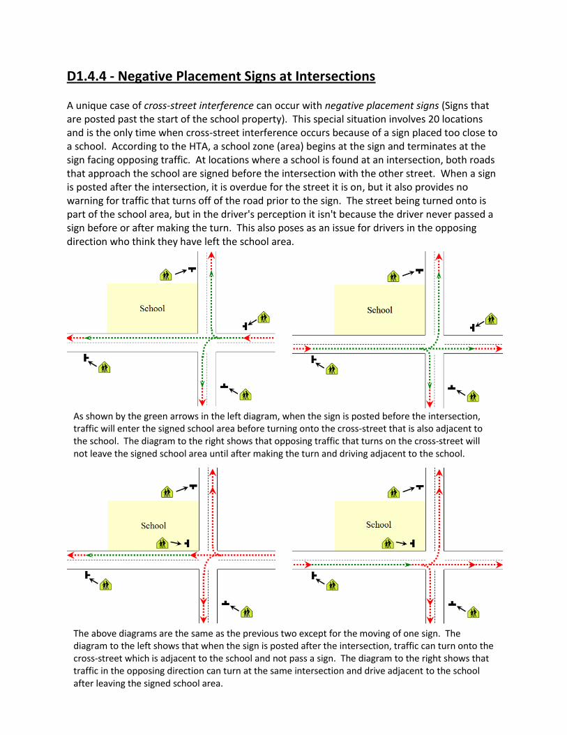
D1.4.4 - Negative Placement Signs at Intersections A unique case of cross-street interference can occur with negative placement signs (Signs that are posted past the start of the school property). This special situation involves 20 locations and is the only time when cross-street interference occurs because of a sign placed too close to a school. According to the HTA, a school zone (area) begins at the sign and terminates at the sign facing opposing traffic. At locations where a school is found at an intersection, both roads that approach the school are signed before the intersection with the other street. When a sign is posted after the intersection, it is overdue for the street it is on, but it also provides no warning for traffic that turns off of the road prior to the sign. The street being turned onto is part of the school area, but in the driver's perception it isn't because the driver never passed a sign before or after making the turn. This also poses as an issue for drivers in the opposing direction who think they have left the school area.
As shown by the green arrows in the left diagram, when the sign is posted before the intersection, traffic will enter the signed school area before turning onto the cross-street that is also adjacent to the school. The diagram to the right shows that opposing traffic that turns on the cross-street will not leave the signed school area until after making the turn and driving adjacent to the school.
The above diagrams are the same as the previous two except for the moving of one sign. The diagram to the left shows that when the sign is posted after the intersection, traffic can turn onto the cross-street which is adjacent to the school and not pass a sign. The diagram to the right shows that traffic in the opposing direction can turn at the same intersection and drive adjacent to the school after leaving the signed school area.

D1.4.5 - Back Lanes As with cross-streets, intersecting lanes should be considered in regards to sign placement. The problem is often corrected by placing the school area sign at the side of an intersecting lane closest to the school. In many cases where this problem occurs, a parallel street will have the school area sign placed after the laneway. Moving the sign would make it consistent with the sign on the next street and not cause an issue with the laneway. Since a city block is over 30 m (usually about 50 m) wide, in 50 km/h zones, school area signs can always be placed on the school side of a nearby lane and still be far enough away from the school. The number of locations that are signed in this manner indicates that other locations could be signed in that same way. See section D1.4.1(3) for more on sign placement measurements. Back lanes usually don't intersect with higher speed roads so locations where the signs are further from the school due to speed are not an issue.
The sign on Blenheim WB is posted west of Des Meuron (left) instead of east of Des Meuron. Des Meuron is also adjacent to the school and is signed south of the intersection. Traffic on Blenheim is given no advance warning of the school and vehicles that turn onto Des Meuron can drive adjacent to the school without entering a signed school area. The right picture shows the exact same problem occurring on Ravelston EB at Day Street.
The diagram to the left demonstrates how two parallel streets will often have the signs in different positions in reference to an intersecting lane. If the sign on the top street can be posted after the lane and still be far enough from the school, the same position should be used for the bottom street.

There are a total of 119 primary and 47 secondary signs that should be moved closer to the school due to an intersecting lane occurring between the sign and the school. These locations are independent of the stats for cross-street interference (See Section D1.4.3). Since 2009, the city has moved the sign on London NB from being north of Government to south of Prince Rupert. This movement eliminated the problem of a back lane occurring between the sign and school. If that sign could have been moved, the other locations can be as well.
Archibald school is located on the east side of Archibald south of Marion. There are three cross-streets that approach Archibald from the west and form the stem of a "T" intersection. These three streets are Guilbault, Gareau and Cote which need secondary signs on the approach to Archibald. There is also a lane west of Archibald that runs parallel to the school and Archibald. Guilbault (left picture) and Gareau EB both have the school area sign posted after the intersection with the lane west of Archibald. Cote has the sign posted before the lane which is inconsistent with the other streets and allows traffic to turn towards the school from the lane without seeing a sign.
Montrose school is located at the NW side of the intersection of Grant and Montrose. The school area signs on Grant WB (left picture) are posted at the east side of Montrose. These signs are right at the school and could have been posted further east at the west side of the lane east of Montrose. The sign on Stafford NB (right picture) approaching Kelvin High School is located just north of Harvard. This sign could be posted further north at the north side of the lane south of Kingsway.

D1.4.6 - Other Placement Related Issues
There are issues related to school area signs that were not examined thoroughly in this study. School area signs were considered to be present regardless of many issues such as obstructions or extreme horizontal and vertical placement all of which can greatly lower the effectiveness of a sign. Obstructions: Many signs were found to be blocked by trees or other obstructions. Some signs were observed to be blocked by trees to an extent that has taken many years for the tree to grow and completely block the sign.
The school area sign on Fleming WB approaching Salisbury Morse Place School at Besant is completely blocked by a tree. The left picture shows the obstructed sign with the school in the background. To the right is a close-up of the sign itself.
The left picture of Simcoe NB north of Sargent appears to be of a very large Elm tree. When the same tree is photographed from the side (right picture), a school area sign is visible behind the tree.

Horizontal Placement: In urban areas, a sign's horizontal placement is measured from the curb face to the nearest edge of the sign. According to the MUTCD, signs in urban areas should be placed between 0.3 and 2.0 m from the road. An internal City of Winnipeg policy known as the "Lateral Setback Policy" states that "The near edge of a traffic sign shall not be closer than 0.3 metres nor further than 3 metres from the edge of the roadway (curb line)." Despite these standards, school area signs are found as much as 11 m from the edge of the roadway. This is over 5 times the MUTCD standard and almost 4 times the City of Winnipeg's policy.
Vertical Placement: The City of Winnipeg has no internal policy stating how high signs are placed but claims that the MUTCD is followed. The MUTCD states that signs in urban areas should be placed at a height of 2.0-3.0 metres. School area signs are found as low as 1.7 metres, and measured as high as 3.8 metres and is more of a problem when combined with other issues. No statistics were collected for the obstruction issue mostly because it is too ambiguous and open to opinion as to where to draw a line between an obstructed and unobstructed sign. Horizontal and vertical placement statistics were not gathered because of the amount of measuring it would have required to check all signs that were borderline. Unlike other signs such as speed limit signs, horizontal and vertical placement issues are not too widespread with school area signs.
The school area sign on Grant EB west of Shaftesbury approaching Shaftesbury High School (left picture) is placed 11 m from the curb face. In sharp contrast to this, the school area sign on Jefferson WB east of Powers approaching Victory School (right picture) is placed 0 m.
The sign on Main Street SB south of Forest is posted too high (3.8 m), too far off the road (5.6 m) and is hidden by trees. The sign could have been posted with the pedestrian crossing ahead (WC2) sign seen in the background.

D1.5 - Dual Signing & Sign Sizes
Unlike other signs, Winnipeg's internal policies have placed special requirements on school area signs that are outside the scope of the MUTCD. Traffic Policy A17 dated December 2009 is known as the "School Area Policy" and is the best source for these internal standards. Special provisions are needed because maximum awareness is imperative and proper signing crucial in school areas.
D1.5.1 - Dual Signing Requirements Section 3 of the School Area Policy states that, "Where School Area signing on divided roadways is necessary, they shall be installed on both the left and right sides of the roadway." This practice is referred to as dual signing and involves placing a second sign on the median of a divided or left side of a one-way street. Although most signs are often "dual signed", school area signs are the only signs where it is required. Dual signing is very essential on divided multi-lane roads where median traffic often has their sightlines obstructed by vehicles in the right lane. Median/left side traffic is also faster flowing and can pose as more of a hazard if drivers do not observe the signs.
Corydon WB approaching Queenston (left picture) is a divided roadway that enters a school area. A median school area sign is posted directly across the road from the primary sign on the right. This practice prevents median traffic from missing the sign due to large vehicles (right picture).

D1.5.2 - Dual Signing Practices In Winnipeg, there are 102 divided/one-way approaches to a school area that require dual signing. Some locations (13) are not dual signed and have not been since before 2009. Most of these 13 locations are on regional roadways. Since 2009, 7 of the 89 locations that were dual signed have had a sign go missing raising the total of locations not dual signed to 20/102.
St. Anne's NB north of Meadowood (left) has a school area sign posted on the median only with no right side sign. Broadway EB east of Picardy (right) has no median school area sign.
In 2009, the school area sign on Henderson Hwy NB north of Springfield was dual signed (left). Since 2009, the median sign has gone missing leaving only the right sign (right).

D1.5.3 - Sign Size Requirements The MUTCD contains the minimum legal sizes for road signs, but does allow for, "proportional increases above this minimum," in 15 cm increments. Any sign that has dimensions larger than the minimum (also referred to as standard sized) found in the MUTCD is referred to as oversized. The standard size for a school area sign is 60x60 cm, but many jurisdictions use a larger size. For example, Manitoba Infrastructure and Transportation only uses 75x75 cm (oversized) signs. The City of Ottawa uses all 75x75 cm signs except on high speed roads where 120x120 cm signs are used. To compare Canada to the United States, the American MUTCD prescribes a minimum size of 75x75 cm for school area signs but states that signs should be 90x90 cm (referred to as conventional sized) with the minimum size only used when engineering judgment determines that the smaller size is more appropriate. Oversized American school area signs are 105x105 cm. The City of Winnipeg mostly uses the Canadian minimum 60x60 cm signs, but section 3 of the school area signing policy does state that, "In areas where speed limits are 60 km/h or more, School Area signs shall be oversized (75x75 cm)."
The school area signs on Dakota NB north of Southglen (left) are 75x75 cm due to Dakota being a 60 km/h zone. The school area signs on Roblin EB west of Haney (right) are 60x60 cm due to Roblin having a 50 km/h speed limit at this location.
The 60x60 cm school area sign in the left picture is just as wide as the No U Turn sign posted on the opposite side of the same pole. The right picture shows that a 75x75 cm school area sign is noticeably larger.

D1.5.4 - Oversized Signing Practices Winnipeg has many signs on higher speed roads that are only 60x60 cm. Of 117 needed school area signs on high speed roads, 12 are missing. Of the 105 that are present, 26 are 60x60 cm (too small) and have been since before 2009. All of the signs that are too small or missing are on 60 km/h roads. The table below demonstrates the number of signs that are undersized or missing for each high speed zone.
Speed Sign Locations Signs Present 60x60 cm Signs 75x75 cm Signs
60 km/h 99 87/99 26/87 61/87
70 km/h 14 14/14 0/14 14/14
80 km/h 4 4/4 0/4 4/4
. Sometimes, undersized signs are at locations with missing signs. There are some locations on 60 km/h divided roads where one of the signs is missing and the only remaining sign is too small.
Portage Ave eastbound west of Bourkevale (left) is four lanes wide which is the highest lane count on any road in Winnipeg. Portage is also the Trans-Canada Highway and a 60 km/h road, but the school area signs are undersized 60x60 cm. Taylor EB approaching Guelph (right) is also a 60 km/h road but has half as many lanes as Portage. The signs on Taylor are the 75x75 cm size.
Grant WB west of Lilac is a 60 km/h divided road that requires 75x75 cm signs and dual signing. What is there is a 60x60 cm sign posted on the right only with no median sign.

It is well known within the signing industry that larger or above minimum sized signs are acceptable and often desirable, but undersigning is not an option. Of 1,322 school area sign positions in Winnipeg, 1,204 are on 50 km/h roads. Of this 1,204, 7 locations have larger than minimum sized signs. The difference in size is very noticeable and greatly increases safety. For 26 signs that are smaller than the minimum size in 60 zones, there are 7 in 50 zones that are larger than the minimum for that speed. One type of location where larger signs would be most beneficial in 50 km/h zones is on roads with multiple lanes.
D1.5.5 - Multiple Lanes Many roadways in Winnipeg have multiple lanes of traffic and dual signing isn't possible due to the lack of a median. Traffic in the left lane of these roadways have sightline obstructions similar to divided roads but without the advantage of a median sign. In 50 km/h zones, there are 107 multi-lane approaches to school areas and 54 (50%) are divided roadways with a median. On roadways with a 60 km/h or higher speed limit, there are 89
The school area sign on Donan NB approaching Red River Blvd is on a residential street with a 50 km/h speed limit. This is one of 7 oversized signs found in 50 km/h zones. The larger size is very noticeable to traffic on Donan.
Sargent EB west of Spruce (left) has two lanes of traffic and no median sign for traffic in the left lane. Tuxedo WB west of Kenaston (right) has the same lane count as Sargent but has two signs because of the presence of a median.

multi-lane approaches to a school area and 81 (91%) of them are divided roads. Apparently, the majority of these multi-lane undivided roads occur in 50 km/h zones where oversized (75x75 cm) signs are not used. To compensate for the lack of a median sign, these 53 locations with a 50 km/h limit could have oversized signs. The locations that would be candidates for larger signs due to having multiple lanes and no median are almost all on regional roads with high traffic volumes and includes streets such as Logan, Sargent, Ellice, McGregor, Mountain, Osborne and William.
Hamilton WB east of Redfern is a 50 km/h divided residential road. This location has oversized (75x75 cm) signs posted despite this not being a higher speed road. Considering the sign size and dual signing, Hamilton is signed about 3X better than many other roads such as Sargent or Ellice

D1.6 - Speed Limits and Reduced Speeds School areas have been a subject of recent debate regarding reduced speed limits. Before a reduced limit could be implemented, there are many other problems to address.
D1.6.1 - Current Speed Limits Since 1967, Manitoba has not had reduced speeds around schools. The speed limit through a school area is the speed limit of the road itself.
D1.6.2 - Speed Limit Signing The most effective way to control speeds is with prominent signing. To read the full report on speed limits and signing, refer to report B1. Among other problems, Winnipeg is the only western Canadian city that doesn't place speed limit signs on both sides of a divided road.
Speed limit dual signing is most essential at speed reductions where the '50 unless otherwise posted' rule doesn't apply. Of Winnipeg's 98 speed reductions, 58 are on multi-lane divided roads and none are dual signed. A total of 24 speed reductions are located before schools and 18 of them are on multi-lane divided roads.
Speed limits through Winnipeg's school areas vary from 50-80 km/h on streets and are 30 km/h in back lanes. The presence of a school has no effect on the road's speed limit.
All other cities such as Saskatoon (left picture) and Edmonton (right picture) dual sign on both sides of a divided road for speed limits.

In addition, many speed reductions are not compliant with city and national signing standards for placement. The MUTCD prescribes that signs should be between 2.0-3.0 m high. Some reduction signs are as low as 0.7 m or as high as 4.8 m. For horizontal placement, Winnipeg policy allows signs to be up to 3.0 m from curb face but speed reduction signs before schools are found as far as 11 m off the road. Of the 24 speed reductions preceding one or more school areas, 16 are non-compliant with vertical and/or horizontal placement standards. According to MPIC, "As your speed increases so does your risk: a frontal impact at 60 km/h is one-third more violent than one at 50 km/h," which shows the importance of properly signing these reductions. Of the 33 school areas located after speed reductions, 23 are after locations that do not comply with standards. Winnipeg is also the only city that doesn't place additional maximum 50 km/h signs on major roads. The city's claim is that they don't sign because the city is "50 unless otherwise posted", but it is well known that speed signs have an impact on speeding. Below is a testimonial from one Winnipeg citizen: Today I received my first speeding ticketing in my 8 years of driving. There was a speed trap located on Provencher at the Belgium Bowling club. I turned onto Provencher from Archibald which has a 60km limit. I was caught at 66km on Provencher and was informed this stretch of road was set at a limit of 50km. In the 6 years I've lived in Winnipeg I have always taken the stretch on Provencher from Archibald to Des Meurons as 60km till I see the FIRST speed sign just past the intersection at Des Meurons +of 50km. I always went 50km from that point on which I completely understood as the set speed for the road from that point on.
There are 122 maximum 50 km/h signs that are not at speed reductions and can be found throughout the city. These signs are not at the most ideal locations. For example, Corydon and Stafford have no speed limit signing (other than the reduction on Corydon), but there are three
The speed reduction (60-50) sign on Grant EB east of Kenaston is signed on the right side of the road only despite Grant being a four lane divided regional road. This sign is also too high and precedes three school areas.
The speed reduction (60-50) sign on Corydon is twice as far (6 m) off the road as permitted by city policy. It is also 4 m high (max 3 m) and is not dual signed on a four lane divided regional road. Four school areas are found after this reduction, the first of which is in the background of this picture.

signs on nearby Wellington which unlike Stafford and Corydon, doesn't have school areas, isn't a regional road, a truck route or a numbered city route. Of Winnipeg's 122 maximum 50 km/h signs, only 15 are preceding school areas and most are so far before the school that they have little impact. Other cities will prioritize speed limit signing on roads with schools, playgrounds and other higher risk areas. In Quebec, school signs are posted with a speed limit sign. "With a view to increasing safety in school zones, the Ministère standardized speed limit signs to be installed under school zone signs."-Government of Quebec
In an attempt to prove that photo radar increases safety, Winnipeg Police showed speed readings from past years to present for many select photo radar sites. The two sites that were listed as showing the greatest reductions in speed were also the only two sites that had speed limit signs (used with a driver feedback sign) added during the time data was collected. At both of these two sites on Grant, the average speed dropped by 8 km/h. This is proof of the effectiveness of speed signing rather than success for photo radar.
Most of Winnipeg's maximum 50 km/h signs that are not at speed reductions are found on residential streets that do not have school areas. The sign to the left is on Argue NB north of Rathgar one block before the road ends.
Quebec school area signs include a speed limit sign such as this oversized speed sign found in Montreal.

Winnipeg does see the advantage of dual signing because almost all other signs found in the traffic manual are dual signed.
D1.6.3 - Reduced Speed Limits Many jurisdictions have reduced speed limits around schools. Practices with regards to implementation and signing vary greatly. Comparable to Winnipeg, Edmonton does not have reduced speeds around schools and has done some very thorough research on this topic. When they apply, reduced speed limits are typically 30 or 40 km/h but 50 and 60 km/h zones can be found on high speed roads in some jurisdictions.
D1.6.3(1) - False Sense of Security One common problem associated with reduced speed limits is that drivers do not comply with them. Edmonton removed school zone speed reductions because, "motorists did not adhere to the lower speed limit. Instead, they provided children and parents with a false sense of security"-City of Edmonton. Edmonton also did a pilot study which determined that compliance with a 30 km/h reduced speed limit is very low (11%). When Saskatoon implemented reduced speeds, only 23% of traffic complied. This level of compliance creates large speed differentials and a false sense of security which has a negative impact on safety. One reason why reduced limits are often not complied with is that drivers do not see a need for them. A driver will react to the presence of children and drive accordingly rather than obey a seemingly too restrictive speed limit at a time when hazards are not present.
Two driver feedback signs with a speed limit sign were added on Grant Ave in 2010. The sites with these signs saw the greatest reduction in speed of all photo radar sites in Winnipeg.

D1.6.3(2) - Signs, Limits and Times
To help deal with low compliance, Ontario provincial law has special restrictions on school zone signs. A reduced speed school zone has a sign that states the speed followed by, "when flashing" and includes two flashing lights that are activated during the times the zone is active. The only alternative to this sign is a rarely used type that is internally illuminated when the reduced limit applies. The Ontario traffic manual states that, "In some jurisdictions, studies have shown that SCHOOL ZONE MAXIMUM SPEED signs (especially the RB-6A version are effective in decreasing speeds, although not to the extent specified on the sign. Other jurisdictions however, have found the sign to be ineffective, unless it is visibly enforced or there are children present." To save money, many cities will use a speed limit sign posted with the applicable time(s) for the zone. The times and limits when reduced speeds apply vary greatly. Some cities will institute limits for the full school day (sometimes 8:00-5:00) while others will only have them active during peak times (morning, lunch & dismissal). Some places have set times, but the limit only applies when passing children. It has been found that the longer the applicable times, the lower the compliance. A city of Hamilton report states that, "Targeting the highest risk periods will maximize driver association of part-time speed limits with student activity. It is not recommended to have the flashing period activated the entire school day as it will likely decrease the effectiveness of the program." Under the Alberta Highway Traffic Act, standard school zone speed limit times are, 8:00-9:30 am, 11:30 am-1:30 pm & 3:00-4:30 pm. Many cities have found that a 40 km/h school zone limit has much better compliance compared to 30 km/h. Closest to Winnipeg, the all Ontario cities and the City of Regina both have maximum 40 km/h limits. In Ontario, the limit is not reduced by more than 20 km/h. Typically, a 40 km/h limit is only implemented on 50 & 60 km/h roads while 70 & 80 km/h roads reduce to 60 km/h and only at locations where a speed reduction is warranted.
School zones with reduced speeds in Ontario have signs (RB-6A) which include flashing lights and state "Maximum 40 when flashing." These signs are found in many Ontario cities such as Hamilton (left) and Toronto (right). They are only at certain schools and only active during peak school times.

A school zone speed sign in the United States. It's unfortunate that compliance stats are not available for this location.

D1.6.3(3) - Prevalence School zone speed reductions often are not universal. This is especially true in most Ontario and Alberta cities. One traffic official in Ottawa estimates that about 1/4 of schools have reduced speeds. In Barrie, Ontario, 19 out of 66 schools have warranted reduced speeds. Alberta has the most detailed warrant criteria which also has been adopted outside of Alberta (Ottawa as one example) to determine if a reduced speed limit is needed on a case by case basis.

Once the chart is completed, the final score is applied to the table below. If the roadway is classified as a school zone, the reduced limit is warranted.
Many cities have found that if reduced speeds are overused, respect and the overall compliance rate decreases. One Ontario provincial traffic official stated that besides increased effectiveness, the expense associated with Ontario school zone signs is significant and ensures that a municipality will only make the investment when the reduced limit is justified. This prevents a municipality from using reduced speeds universally and lowering their effectiveness. Ontario school zone signs are expensive and more effective because they must include flashing lights or be internally illuminated and only active during school times.
D1.6.3(4) - Engineering and Education One traffic engineer in Alberta stated that the need for a reduced speed limit in a school zone is often associated with weak engineering. When proper loading and unloading facilities are provided, non-traversable fencing installed, marked crosswalks used appropriately and other measures in place, a reduced speed is not needed. The best collision stats that could be found were compiled by the City of Edmonton. Edmonton does not have reduced speed school zones and was compared to Calgary which does have reduced speeds. "Comparison of collision history with the City of Calgary also verifies that 30 km/h school zones do not result in lower collision rates for child pedestrians"-City of Edmonton report. For a three year period, Calgary had 5.67 collisions per 10,000 elementary aged children compared to Edmonton which had 4.82. This report also stated that Calgary is considering removing reduced speeds from school zones and that other cities are following Edmonton's lead by not having school zone reduced speeds. The city of Edmonton has many programs to keep children safe at all times. "Programs include the Parent Parking Patrol; the School Crossing Patrol; the Point, Pause and Proceed method; the Radar Speed Display program; and the Pedestrian Safety Campaign."-City of Edmonton. The Alberta Motor Association (Alberta's version of CAA) researched school zones and found, "that there is no conclusive evidence that school zones result in crash reductions, although they may provide an increased perception of safety in the community"-City of Edmonton. Some traffic officials feel that children are not properly trained on how to be safe around roads when a reduced speed limit is implemented. This can increase collisions outside of school zones when the children are walking to and from the school or on the child's own street during a non-school time.

D1.6.4 - Manitoba Data
School area collisions are so rare in Manitoba that MPIC has no category in its annual collision reports for schools. Since the removal of reduced speeds in 1967, there have been no accidents significant enough to be publicized. The City of Winnipeg has been on a campaign for years to reduce speeds around schools, but have no collision data to prove a need. The only cause given by the city is that they want to be proactive. Considering that Manitoba has many school areas (262 in Winnipeg alone), if there was a need, there should be a collision history to prove it. One former MPIC employee stated that in 5 years of processing about 35 accident claims per week, he has only seen one accident that occurred in a school area. That one accident didn't include a pedestrian. It involved one car parallel parking and the other car illegally passing. As shown by Calgary, school zones with reduced speeds do have collisions. In Manitoba, with no collisions to speak of, it would appear we were doing something right. Edmonton has found that the majority of collisions involving children occur outside of school areas. The table shows that school area collisions represent a very minimal amount of collisions involving children. Edmonton's final conclusion was that collisions in school areas during school times represent 8% of collisions with elementary aged children. Considering the vast number of school areas in any city (including Edmonton), this data proves that school areas are already safer than other roads. Edmonton also found school zone collisions during school times represented 0.6% of all pedestrian collisions. To justify reduced speeds in Winnipeg, statistics must be gathered to the detail compiled by Edmonton and Calgary. These statistics could then be compared to determine if there is a need in Winnipeg.
The table above is created from data contained in a City of Edmonton collision report for elementary aged children.

D1.6.5 - Speed Studies Information can be found that has been used to give an indication of driver behavior in school areas/zones. From Sept 22-28, 2011, Winnipeg Police recorded speeds of 38,890 vehicles on Day Street near Ecole Centrale (Winnipeg Free Press). The numbers police gave were that 16,443 vehicles travelled above 51 km/h and 2,662 travelled above 60 km/h. Although these numbers may appear to indicate a speed problem in the school area, there is no indication of when those speeds were recorded. Data collection occurred through the weekend (the article stated that highest speed was recorded on Sunday) and may easily have included evenings when the school was inactive. There was no indication given if police were present during school times. Speed studies must be done during school times and especially with children present to determine a speeding problem. Only one study could be found that did a detailed breakdown of speeds throughout a school day. It found that speeds are lowest at the start or end of the school day and increase as time progressed away from the start or end bells. When Saskatoon instituted reduced speed school zones, they had a 77% non-compliance rate, but claimed reduced speeds were successful because the 85th percentile speed dropped from 54-44 km/h. The information not presented from Saskatoon was at what times those speeds were recorded. Unlike many jurisdictions, Saskatoon applied their reduced speeds throughout the entire school day rather than peak times. It is very much possible that speeds during the times kids are around were already slow due to awareness and congestion. The reduction in 85th percentile speed could have occurred during times that students were not active outside the school which is of little to no benefit. Studies have found that overuse of stop signs can increase speed between signs because drivers try to make up for lost time. Overuse of school zones and times may have a similar effect. Any decrease in speed that occurs unnecessarily (when children are not around) in a school zone may increase speeds elsewhere.
Saskatoon's reduced school zone speeds are amoung the most restrictive in the country for times and speed. These times begin before school starts, continue throughout the day while kids are in classes and continue well after school is done for the day.

D1.6.6 - Winnipeg Design
Over half of Winnipeg's designated school crosswalks are outside of school areas and will not be protected by a speed reduction. A reduce speed in Winnipeg school areas will cause many unforeseen problems. When Saskatoon instituted reduced speeds in school zones, they did before and after studies which determined low compliance as well as a 13% drop in traffic volume because some people avoided the zones. Winnipeg is different than many cities (Saskatoon included) for having a school on most major roads. In Winnipeg's future reduced speed school zones, any decrease in volume may create new problems because it could cause traffic to cut through residential streets to avoid zones on regional roads. The table below shows the number of school areas found along each city route followed by the highest speed limit found along each route within a school area.
Route Number Common Names School Count
Highest Speed
17 Chief Peguis Trail 0 -
20 Lagimodiere 1 80
23 Leila 0 -
25 Inkster 0 -
30 Archibald 1 60
37 Regent, Nairn, Hespeler 2 60
42 Pembina, Donald, Disraeli, Henderson 6 60
47 Logan 2 50
52 St. Mary’s, Main 4 60
57 Dublin, Notre Dame, Provencher 1 60
62 Dakota, Dunkirk, Osborne, Isabel, Salter 5 60
70 Stafford, Maryland, Sherbrook 5 50
80 Waverley 0 -
85 Portage 2 60
Most of Winnipeg's school crosswalks such as the one on St. Matthews at Spruce (left) and Corydon at Lanark (right) are outside of a school area or soon to be school zone.

90 Kenaston, Century, Brookside 0 -
95 Roblin, Corydon 5 50
96 Shaftesbury, Grant, Charleswood Pkwy 2 70
105 Roblin, Grant 5 60
115 Marion, Goulet, Dugald 0 -
125 Jubilee 0 -
135 Fermor 1 70
145 Wilkes, Sterling Lyon Pkwy 1 70
150 St. Anne’s 2 60
155 McGillvray 0 -
165 Bishop Grandin 0 -
180 McPhillips 2 60
There are a total of 47 school areas located along Winnipeg's metro city routes with the speed limits ranging from 50-80 km/h.
D1.6.7 - Self Regulation
Schools are already areas of heightened awareness where drivers have an expectation of children being present. The large groups of children commonly found in school areas are easily spotted and drivers will slow down accordingly. At a bigger risk is the single child who unexpectedly darts out onto a road during a non-school time; most likely on their own street. Overuse of reduced speeds will create an unnecessary hindrance to traffic flow during times that children aren't absent. This will often be during the day time when children are in the school. At peak times, schools are often self-regulating due to congestion. In regards to a reduced speed, Edmonton Police Service stated that, "Although the designation of a particular area around a school may appear to offer increased safety for pedestrians and other users of the highway, the reality is quite different. Our experience to date centers mainly around congestion and the problems associated with low speed and poor traffic flow." A City of
During daytime hours, the school areas are as empty as they would be during a weekend or holiday because all the students are in classes. A reduced speed at these times would unnecessarily obstruct traffic flow; especially on major roads.

Edmonton report states, "The main traffic concerns during school drop-off and pick-up times are congestion, improper turns, and failing to yield to pedestrians. Speed is generally not a major issue." The same problem can be easily observed in Winnipeg during times that students are entering or leaving a school. Congestion is the much bigger issue than speed.
D1.6.8 - Reduced Speed Enforcement Winnipeg Police have shown support for the reduced speeds at schools, but have given no indication as to how they plan to enforce it. Photo radar has numerous issues and would not be an adequate enforcement tool for these new limits. The low compliance associated with reduced speeds will be a significant drain on police resources and an unnecessary drain if the speeds are not justified. In regards to a possibility of reduced speeds during a 2005 review, Edmonton Police stated, "Traffic problems around schools create a significant demand for service...Our hands are full just dealing with the violations currently being encountered. Implementing reduced speed zones around schools will create an expectation that they will be enforced. At this time we simply do not have anywhere near the resources needed to accomplish this. Police officers would have to be diverted from other much higher priority enforcement location to do the work. Locations associated to high collisions and fatalities will receive reduced levels of attention." In comparison, Winnipeg Police have stated that a reduced speed is a "no brainer."
D1.6.9 - Manitoba's Future Manitoba has just passed legislation allowing municipalities to institute reduced speeds around schools. One issue that has surfaced in other provinces is a lack of consistency. One traffic official used the word "mayhem" to describe the apparent randomness of school zone usage when municipalities are given control. Municipalities (primarily smaller) are often less experienced dealing with proper speed limit setting compared to a provincial department and are often susceptible to local pressures which may not be the best solution. Other Canadian cities set their speed limits with local bylaws, but in Manitoba, all speeds are in the Highway Traffic Act regulations and under the jurisdiction of the Highway Traffic Board (HTB) which is part of the provincial government. One solution that would help create uniformity would be to have the HTB serve as the regulating body over school zones. A municipality could apply for a reduced speed and through a warrant criteria list such as what Alberta has, the HTB would
Congestion during school times makes school area speeds self-regulating.

make the final decision. This would remain consistent with the Manitoba method of maintaining provincial control over speeds and ensure a consistent application of school zones across the province. If justified, school zones may work if they are used only at the locations that are most in need. Priorities would be elementary schools, areas with sightline obstructions, collision history and other variables.
D1.6.9(1) - Bad Signing, Traffic Flow and Compliance
The difference between doing 30 km/h versus 50 km/h is significant. One issue that isn't realized will be the additional time delay caused by sign placement. Alberta provincial standards place a reduced speed school zone sign 30 m preceding the school on a 50 km/h road. This is also the standard found in the nation-wide American MUTCD. On Winnipeg's 50 km/h roads, school area signs are found as far as 323 m from the school. If reduced speeds are instituted and applied with the signs in their current locations, the Winnipeg zones will be up to 586 m longer than Alberta's. This was determined by taking the 323 m that can be found for sign placement in Winnipeg, subtracting the 30 m from Alberta/United States to get the difference and multiplying by two to account for both directions. The table below represents the time it takes to travel that distance at 30 versus 50 km/h.
As the table above shows, with current sign placement, a single Winnipeg school zone will take up to 28 seconds longer to drive through at a reduced speed compared to a similar zone in Alberta. This difference is in addition to the 12 sec (Saskatoon estimate) for driving the slower speed past the school itself and the distance that would be included with standard sign placement. This time adds up; especially when multiple zones have to be passed through on a single trip or if the location involves a previous 60 km/h or higher limit. Considering Edmonton found that school speed zones were not complied with by 89% of traffic, it can only be imagined what the compliance rate would be reduced to in these extended zones Winnipeg may create.
D1.6.9(2) - Speed Although school zones are not proven to increase safety, they do create the perception of safety. One alternative to 30 km/h limits would be to have 40 km/h limits which are what our closest Canadian neighbors use. A 40 km/h limit would reinforce the perception of safety and make the province/city proactive while lessening the negative effects on traffic flow. This slightly higher speed would also see a much smoother transition than converting speeds from 50-30 km/h and higher compliance which would lessen the effects of a false sense of security. Manitoba does not presently have significant school area collisions with a 50 km/h+ limit, so 30 km/h would be too restrictive, unnecessary and ineffectual.
Speed Limit Meters per Sec Time to Travel 586 m
30 km/h 8.33 m/s 70 seconds
50 km/h 13.89 m/s 42 seconds
D1.6.9(3) - Signs
Manitoba should utilize signs with flashing lights such as those used in Ontario. The cost of
implementing a reduced speed school zone in Ontario is significant (about $15,000) and ensures
that school zones are not over used which creates more respect for the limits. If Manitoba
followed this example, only municipalities that have a genuine interest in safety would invest in
these signs which should only be at locations approved by the province. Ontario also has found
that these signs with flashing lights have created much higher compliance. A study done by the
State of Texas was very comprehensive and studied school zones across the United States and
Canada. This study surveyed law enforcement officials from across the country and found that,
"most of the participants agreed that the speed limit sign needed the flashing amber lights for it
to be effective." When informed that signs in some western Canadian cities just show the times
on the sign, an Ontario traffic official said, "and by whose clock does that work." The flashing
lights ensure that drivers know the school zone is active. Flashing lights also give more
flexibility because they can be adjusted for changing school times. This would include the sign
being deactivated for statutory holidays or adjusted for a school event or early dismissal. In
Ontario, having different times for each school is often done to adjust for each school’s schedule.
With flashing lights, this does not create a consistency issue.
D1.6.9(4) - Times
As stated by many traffic officials, school zone speeds are only justified and most often complied with during times that children are entering and leaving the school. For example, school zones (reduced speeds) in Barrie Ontario are only at elementary schools and only apply 30 minutes before arrival time to 15 minutes after arrival time, 15 minutes before lunch to 15 minutes after lunch and 15 minutes before dismissal to 30 minutes after dismissal. In Barrie, there is no confusion over having multiple times on a sign because the signs have an active flashing light when the speeds apply. Many Alberta and American school zone times are also similar to those found in Ontario. An extensive American study on school zones stated that school zone speeds should generally only be active, "from approximately 30 minutes before and 5 minutes after classes begin, from the beginning to the end of the lunch period for open campuses, and from approximately 5 minutes before and 30 minutes after classes end."
D1.6.9(5) - Signs When reduced speeds are instituted, Manitoba needs regulations that strictly control all aspects of signing. Manitoba regulation needs to control how close the signs are to the road, how high the signs are, that the signs are free of obstructions and especially the exact placement of the signs. The minimum sizing of signs will have to be covered in detail. The best method would be to adopt Alberta's standards and expand from there as necessary.

D1.7 - Enforcement
Current speed limit enforcement at schools is largely done by photo radar. Winnipeg Police officers are more commonly found enforcing roads without school areas where higher speeds are recorded. Bishop Grandin Blvd, Lagimodiere, Pembina Hwy south of St. Norbert, the Maryland Bridge and Kenaston are common police enforcement hotspots.
D1.7.1 - Photo Radar Winnipeg began using mobile photo radar units (MPR) in 2003. Winnipeg, Edmonton and Calgary are the only western Canadian cities that deploy MPR. These units have been removed from B.C. and Ontario and have never been allowed in Saskatchewan. Under the Manitoba HTA, MPR units are only allowed to enforce in school zones (areas), playground zones (areas) and construction zones which are legally defined and must be signed. Currently, Winnipeg deploys 10 MPR units which are active from 7:00 am to 9:00 pm every day of the year. All photo enforcement is run by a private company (ACS) under contract with the City of Winnipeg.
D1.7.2 - Warning Signs Other jurisdictions that utilize MPR post warning signs at enforcement sites. Since Winnipeg is only allowed to deploy units at schools, playgrounds and construction zones, warning signs are not posted because the signs marking those zones serve as warning. This second purpose means that school area signs must be present and properly posted not just for the safety of the area, but also as warning of photo radar.
This MPR unit photographed on Grant Ave is 1 of 10 deployed daily within Winnipeg.
Other cities such as Edmonton that deploy photo radar will post warning signs before all enforcement locations. This is not done in Winnipeg because photo radar is only allowed in certain areas that are already marked with signing.

D1.7.3 - Limitations Unlike traditional enforcement, there are many factors that restrict where MPR can be used. These units can only be on a perfectly straight road in areas where parking is permitted and when a parking spot is available. Many areas that are enforcement sites are also unusable during part-time stopping restrictions. Most part-time restrictions apply 7:00-9:00 and/or 15:30-17:30 Monday to Friday which are peak school hours when school safety is most imperative.
D1.7.4 - Chosen Sites The locations chosen for MPR deployment are quite selective. After considering the restrictions, there are still many possible sites that are neglected. Units can only enforce after primary signs because a roadway must be adjacent to a school to be a candidate for enforcement. Of a total 262 school areas in Winnipeg, 119 (45%) are listed as MPR sites. Most school areas that have photo radar usually include more than one street but MPR often only enforces one of the streets and only in one direction. A better indication of what proportion of areas are photo enforced is to consider the number of primary sign locations that are enforced. Of 1,027 primary sign locations in Winnipeg, 168 (16%) precede MPR sites. This gives the best indication of how widespread photo enforcement is.
Portage Ave (left) has a no stopping restriction from 7:00-9:00 Mon-Fri. Stafford (right) has a no stopping restriction 7:00-9:00 & 15:30-17:30 Mon-Fri. Both of these locations are photo radar sites outside of these hours.
The diagram to the left shows that the number of potentially photo enforceable roads and directions is normally equal to the number of primary signs. Secondary signs are on roads that approach (not abut) a school and are therefore not photo radar enforceable. "P" for primary or "S" for secondary is shown under each sign on the map.

Of 168 primary school area signs that are photo enforced, 72 (43%) are on roads that are regional and/or truck routes. In comparison, only 16% (162/1027) of primary (enforceable) sign locations are on these roads. Photo radar has a preference for enforcing on major roads rather than residential streets.
These numbers would show how much photo enforcement occurs on major roads versus residential streets, but the amount of time units spend at each location is also important. Many sites on regional roads will have enforcement on a daily basis while some locations on residential streets do not see enforcement.
In the photo enforcement annual report, speeds at specific sites are reported. Of the 168 photo enforcement sites, 54 are listed in the annual report. Of this 54, 32 (59%) are on regional roads/truck routes. The provincial conditions of authority which enables the City of Winnipeg to run photo radar states that the photo enforcement annual report must include, "Hours in which photo enforcement units operate at each location." Despite this, the City of Winnipeg claims to have no records in regards to specific enforcement sites other than a list of the sites.
Ashland WB west of Mabel runs directly adjacent to a school, is a straight road and has parking but photo radar is not deployed there.
Blenheim WB west of Des Meuron is listed as a photo enforcement site on a residential street, but all residents surveyed stated that they have never once seen a photo radar unit on their street.
Sites on regional roads/truck routes such as Corydon EB west of Brock-Corydon School has almost daily enforcement.

D1.7.5 - Tricks of the Trade Many factors help determine which photo radar sites are most lucrative with the most prominent being signing. It is well known that some roads have issues with the set speed limit being too low, but that is outside the scope of this sign study. Almost all of the sign issues covered so far create enforcement opportunities. Below are some of the common issues found at enforcement sites.
D1.7.5(1) - Missing Signs Section D1.3 covered the amount of missing signs in Winnipeg, but didn't address the issue of missing signs preceding photo radar. The primary sign preceding an enforcement location is almost always present, but there are still problems. One issue is that many sites are missing secondary signs which are common access points to enforcement sites. In most cases, the photo radar unit is parked far enough away from the access point to allow traffic to accelerate to full speed and receive a ticket. Of the 119 out of 262 school areas with photo radar, one or more signs are missing at 48 locations. In some cases, the side road with the missing sign will be a high volume roadway.
It is obvious that a minimal percentage of vehicles travelling on Portage Ave westbound would have entered from Century Street southbound. On average, photo radar tickets 0.385% of monitored vehicles (2011 statistics). It is most likely that an inflated proportion of those ticket receivers would be drivers who didn't know they were in a school area and had no warning. The proportion of ticketed vehicles that enter from an unsigned cross road has been further indicated by the Winnipeg Police. Grant Ave westbound west of Nathaniel is Winnipeg's newest MPR location and has been subject to recent scrutiny due to the possible inaccuracy of
The map to the left shows how a driver can travel from Century (Route 90) southbound to Portage Ave (Route 85) westbound without passing a school area sign. The washed out signs are missing and the one with the red circle is the sign in question. Within the first two blocks of Portage Ave, a photo radar unit is often enforcing even though these drivers have had no warning due to the missing sign on Queen Street.

the radar. Many drivers claimed it was impossible for them to be speeding because they had entered Grant from Nathaniel Street and didn't have sufficient distance to accelerate to a high speed before passing the radar unit. To defend the radar's accuracy on Grant, Winnipeg Police Sargent Doug Safioles stated, "He cannot keep up with the offenders. They're all making the left-hand turn (off Nathaniel). You can easily get up to above the posted speed limit."-Winnipeg Free Press Dec 13, 2011. This statement indicates that traffic does easily get up to a high rate of speed when entering a photo radar site from a cross-road, but also that "all" the speeders on Grant were coming off of Nathaniel.
There is no other explanation as to why "all" of the speeders on Grant entered from Nathaniel unless this missing sign played a role. At some photo enforcement locations, school area signs have gone missing but enforcement continues in the absence of the signs.
The diagram to the left demonstrates how a driver can proceed past a missing sign location on Hector, turn onto Nathaniel and then enter Grant westbound. Some of the traffic on Hector could also be drivers entering from the back exit of Grant Park Mall and using Nathaniel to enter Grant from a signalized intersection.
The right side school area sign on St. Mary's NB north of Crystal has been missing for almost two years. Photo radar has continued enforcing even though the median sign is all that remains. The remaining sign is also too small for being on a 60 km/h road.

D1.7.5(2) - Multiple Schools Some photo enforcement is done in areas that have multiple schools such as described in D1.3.3. When two schools are located along the same road, signs should be present between the schools to terminate and re-establish the school area for each school. The school areas that encompass multiple schools can be as much as 0.65 km long and include up to three schools. They are also so large that they are often listed multiple times on the photo radar site list for each individual school. A school area legally terminates an equal distance after the first school as the first sign was before that school. Since there is no signing between the schools to re-establish the school area, the second or even third school should be considered unsigned and illegal for photo enforcement use. Of 15 school areas that need signing between the schools, 11 (73%) of them have photo enforcement which is higher than the overall average of enforcement being in 45% of Winnipeg's total school areas.
D1.7.5(3) - Extended Sites The Manitoba HTA allows photo radar at certain types of locations one of which is school areas. It states that school area enforcement can occur between the school area signs, but it gives no specification as to where those signs must be posted in reference to the school. When signs are too far from the school, this is enables MPR to enforce the entire road length as a school area. At many photo radar sites, the units will sit closest to the start or end of the school area at a point just past the sign. The further a unit is from the school itself, the higher the recorded speeds will be.
Photo radar units often enforce eastbound Killarney in front of Acadia Junior High. The only school area sign preceding this location is before Fort Richmond Collegiate which is west of this location. There is a large open space between the schools where drivers will easily think they have left the school area after passing Fort Richmond Collegiate. Another very similar location to this is Munroe west of Watt.

Many MPR locations have the signs so far from the school that an unsigned cross-street is found between the signs and school. This gives opportunity for cross-street traffic to unknowingly enter the area without seeing a sign (cross-street interference-Section D1.4.3) and also provides for extended enforcement areas. Of the 71/119 photo radar sites that do not have one or more signs missing, 39 have cross-street interference. Only 3 of those 39 have supplementary signs placed on the cross street. Overall, only 35/119 photo radar enforced schools have proper signing on all approaches to the enforcement area. At some locations with a single school, the signs are found so far from the school that two photo radar sites are listed for the same site.
Grant westbound at Montrose School (left picture) is not photo radar enforced and the school area signs are posted immediately at the school. Only the width of the cross-street is the distance between the school and signs. Corydon eastbound approaching Brock-Corydon School (right picture) is enforced almost daily where units sit right after the signs. The Corydon signs are posted on the second block from the school. There are two laneways and a street between the school and these signs.
The school area sign on Des Meuron northbound approaching Marion School should be north of the traffic lights (Cathedral Ave) in the background of the picture. This sign is so far from the school that there are two unsigned roads entering this area between the sign and school and two separate locations on Des Meuron northbound listed as photo radar sites for this one school.

D1.7.5(4) - Lack of Speed Signs Overall, 86% of photo radar is done on 50 km/h roads (including school and playground areas) and 92% of those 50 km/h roads are unsigned. Photo radar has a preference for enforcing on regional (arterial) roadways, but 50 km/h speed signs are usually not on these roads. Approximately 60% of Winnipeg's selective (not at a speed change) 50 km/h signs are not on regional roads and the few signed regional roads almost always lack schools. The few schools that are found after a speed limit sign are usually not MPR enforced. One specific type of location that photo radar has a preference for is unsigned 50 km/h roads right after an intersection with a high speed road. Traffic entering these roads are often used to doing a higher speed and without a sign, often get photo enforcement tickets. Most other cities use maximum signs on a 50 km/h road that intersects a higher speed road. Some cities such as Saskatoon will sign all roadway leaving 60 km/h+ roads while others such as Ottawa will sign if the higher speed road has a limit of 70 km/h or higher. Winnipeg has some signs used in this manner, but all are on roads not photo radar enforced.
Lucus Ave eastbound east of Brookside Blvd (Route 90) is one of few school areas with a speed limit sign preceding a school. Lucus eastbound is not photo radar enforced. Lucus isn't a regional road, but many regional roads such as Hespeler, Arlington, Mountain, Ellice and Sargent are photo enforced and have no speed limit signing.
The diagram to the left demonstrates how a driver that turns onto Talbot westbound from Gateway will have not passed a school area sign and have no warning of the upcoming photo radar. If the sign on Talbot westbound were closer to the school, it would be west of Gateway. The next major road north of Talbot is Chalmers where a school is located just as far west of Gateway as the Talbot school. The sign on Chalmers for is placed at the west side of Gateway.

Even on 60 km/h roads where speed limit signs are required, enforcement can be found where speed signs are missing. For example, the speed signs on Pembina southbound (SB) south of McGillvray, Portage Ave WB west of Century and Henderson Hwy SB south of McLeod were all missing and preceded schools that are heavily photo enforced. Complaints made during this study were successful in getting those signs replaced.
D1.7.5(5) - Speed Reductions The best photo radar sites are after poorly signed speed reductions. In almost all cases, the reduction is on a multi-lane divided road and signed on the right side of the road only compared to other cities which sign speed reductions on both sides of the road.
Bishop Grandin is an 80 km/h regional road. There are six 50 km/h roads/directions that intersect with Bishop Grandin. Lakewood northbound (NB), River Ave NB and River Ave SB have maximum 50 signs facing traffic leaving Bishop Grandin and no photo radar. Shorehill SB, Island Shore SB and Seigneurie SB are not signed and have photo radar.
The speed reduction on Moray SB at Ness is only signed on the right despite being on a multi-lane divided road. After this reduction, mobile photo radar enforces on a daily basis. Close-up shots show that the Moray sign is also buried in trees. Despite repeated media coverage, the sign is still hidden.

Other major issues with speed reductions are that the signs are often too high, too far off the road and are non-reflective.
D1.7.5(6) - High Speeds Ironically, there are no school area signing problems in 70-80 km/h zones and also no photo radar. There is photo radar on 60 km/h roads and many locations have problems. The issue with signs being smaller than required (Section D1.5.4) is most prominent at photo radar sites. There are also missing signs and locations that are not dual signed at photo enforced school areas on 60 km/h roads. Overall, of 28 photo radar enforced school areas on 60 km/h roads, 16 are not compliant with school area signing standards.
D1.7.6 - Illegal Enforcement Photo enforcement does some enforcement that is fully illegal under the HTA. Of the 32 school area signs that are not located at schools, 6 have photo enforcement after them.
Many speed reduction signs preceding school areas are non-reflective and invisible at night. Other signs such as no parking or snow route are fully reflective. Photo radar also chronically enforces after these signs at night time.
General Vanier School is located on Lomond Street north of Patterson. A school area sign is posted on Lomond northbound north of Patterson which starts and ends the school area. Patterson which is outside of this area also has school area signs with photo radar illegally enforcing the eastbound direction. Under the HTA, the school must be adjacent to the road to allow photo radar. Patterson isn't adjacent to the school because there are three houses between the school and road.

D1.7.7 - Other Photo Radar Shortcomings Compared to traditional enforcement, photo radar falls short in many ways. Winnipeg Police have claimed that photo radar holds the driver "accountable" when in reality, the owner of the vehicle is ticketed rather than the actual driver. Since photo radar cannot identify the driver, no license points are assessed. If speeding in school areas is most dangerous, it's strange that those are the speeding offences that don't go on a driver's record. It's very hard for drivers to defend themselves because of missing signs since the courts don't give "weight" to pictures not taken the day of the offence. The driver has no way of taking the pictures the day of because the ticket doesn't come until two weeks later. Also, photo radar does not stop the offending driver and prevent them from continuing at a high rate of speed. Due to photo radar being operated by a for profit private company, it is aimed at maximum revenue rather than safety. Units generally avoid enforcing when children are present even though the few people who do speed past children are most deserving of a ticket. The observation is that when the schools are active, the units enforce at playgrounds and move to the school areas in the evenings and weekends. Police enforcement is often lacking in school areas because of photo radar. This prevents other dangerous offences such as drinking and driving, cell phone use and other non-speeding offences from being adequately enforced at schools. A driver that engages in this most dangerous behavior should have the greatest chance of being caught at a school rather than a lesser chance. Photo radar units are often blocking busy lanes of traffic. For example, the no stopping restriction on Stafford ends at 17:30 and at 17:31, photo radar usually sets up to ticket rush hour traffic that is still flowing. No other vehicles are seen parking on this road when it is still very busy. Photo radar operators often have little regard for parking laws and will be seen in no parking and no stopping areas.
The sign on Archibald SB approaching Archibald School was removed while road work was being done during the summer of 2011. While the sign was lying down, photo radar continued enforcing this road two blocks up at the school and away from the construction.

D1.7.8 - New Opportunities Photo enforcement revenues have been continuously falling due to public awareness and especially many campaigns against the units. In anticipation of the new reduced speeds at schools, Const Ray Howes stated that police may start "to enforce speed laws in areas where they haven't before." There is a history of changes being made by the city and province in attempt to maintain revenue. In 2004, the photo enforcement program turned a deficit and the province had to more than double the speeding fines making them the highest in Canada and the program profitable again. A court case in 2009 saw hundreds of photo radar tickets from construction zones dismissed due to insufficient signing. Within two months of the court decision, the city began an effort to remove median warning signs before intersection cameras for what they called "median clean-up" but only involved photo enforcement signs. Overall, 79 signs were removed preceding intersection cameras which was only four years after the city did a public relations campaign claiming that the signs had reduced speeding by 66%.
Before (left) and after (right) pictures of Grant westbound approaching Wilton demonstrates the removing of warning signs before intersection cameras.
This photo radar unit photographed on Corydon is parked between the no stopping sign and the crosswalk. Parking/stopping is prohibited on the approach to a crosswalk so that traffic has a clear line of sight to pedestrians entering the crosswalk.

When informed of Manitoba's plans for reduced speeds one traffic engineer from another province stated that it sounds like Manitoba is looking for ways to make more money. His city only has 40 km/h reduced limits and only at elementary schools and the signs have a flashing light. In Saskatoon, 15% of speeding tickets issued are for speeding in a reduced speed school zone. Winnipeg already issues 3X more speeding tickets per capita than Saskatoon. That number is expected to increase with the new lower speeds.

D1.8 - Final Remarks & Conclusions
This section will discuss current trends with school area signs, summarize the issues presented and give final recommendations.
D1.8.1 - Signs Added and Removed Up until this point, all signs that were listed as missing have been absent for more than three years. This was confirmed by comparing Google street-view (from 2009) to present signing in 2012. During the writing of this report, a total of 11 signs which were missing in 2009 were observed to have been replaced. When a new sign was located, it was added to the lists and not recorded as missing in previous sections. It is unavoidable for some signs to go missing with one reason being that signs were not replaced when Manitoba Hydro conducted light standard changes.
The school area sign on Red River Blvd WB approaching Riverbend Community School was missing in 2009 (left). Sometime prior to 2012, the city replaced this missing sign (right).
In 2009, the school area sign on Lomond NB north of Paterson was on a light standard. In the fall of 2011, Manitoba Hydro changed the light standard and as of June 2012, the school area sign has not been reinstalled on the new pole.

What's disconcerting is the quantity of signs that have gone missing between 2009 and 2012 compared to the number that were replaced. If the city were keeping up, the number of new signs should be about equal to the number of newly missing. Considering the state of the signing, it would have seemed appropriate for the city to install more signs in an effort to catch up to the number that have been missing for years. From 2009-12, a total of 11 signs were replaced and 40 signs have gone missing with an average annual rate of -10 signs per year. Overall, the number of missing signs has gone from 177 in 2009 to 206 in 2012. This shows that the city of Winnipeg is falling behind with school area sign maintenance and if this continues, by the year 2024, Winnipeg will be missing 25% of its school area signs. At that point, it is estimated that 90% of schools will be missing at least one sign.
D1.8.1(1) - Other Signs Since school area signs are for children's safety, they should be one of the highest priority signs for proper maintenance. There appears to be a priority on other signs over school area signs. Many sign installations that must have been damaged or gone missing were replaced without the school area sign. The city appears to be very capable of finding and replacing missing signs (especially parking control signs) except when it involves a school area.
The school area signs on Parr NB north of College (left), Whellems EB east of Appleton (middle-left), St. Mary's NB north of Crystal (middle-right) and London NB north of Consol (right) were all present in 2009 and can be seen on Google street-view. All of these signs shared a sign pole with a no parking or snow route sign.
The above pictures of the same locations show the sign installations as they appeared in 2012. In all of the four examples, the signs had apparently been damaged and needed to be reinstalled. These locations had brand new sign posts with new no parking or snow route signs with only the school area sign not being replaced and remaining missing as of June 2012.

The problem with other signs being replaced except for school areas is not isolated to installations on sign posts. It is also present at locations where a light standard was replaced by Manitoba Hydro.
D1.8.1(2) - New Redundancies All of Winnipeg's redundant signs that were present in 2009 are still present in June of 2012. In addition to the 2009 redundancies, three more have been added by 2012 including one other on a street without a school.
The school area signs on Spruce NB north of Percy (top-left) and Beresford WB east of Daly (bottom-left) were present in 2009 on light standards. Since 2009, Manitoba Hydro replaced the light standards and the signs went missing. At both locations, the city reinstalled the no parking signs (right pictures) without replacing the school area signs. They also added a neighborhood watch sign at the Spruce location. A resident of Spruce Street said the pole was changed around the fall of 2010 which corresponded with the Nov 2010 date on the new no parking sign. This shows the speed at which the city replaced the no parking sign while as of June 2012, the school area sign is still missing,
The school crosswalk on Southglen at the east side of Hirt Crescent (left picture) is between two curves and has obstructed sight lines. Due to the obstructions, the city placed school crossing ahead signs (WC16) on eastbound and westbound (right picture) Southglen approaching this crosswalk.

D1.8.2 - Using Enforcement for Improvement In other cities, the police are used as a tool to identify problems as well as to conduct enforcement. One traffic official in Nova Scotia stated that improved (larger) speed limit signs have been installed on some streets at the special request of police. A similar story came from another official in British Columbia who stated that they have monthly meetings with police to discuss problem speed areas and ways to improve the infrastructure. In these other jurisdictions, the police will identify problem speed areas and have improvements made to try and solve the problem. Winnipeg Police claim to have no part in these kinds of efforts with one quote being, “Traffic Services City of Winnipeg is responsible for signage." The response to one direct request to police to ask for improved signing was answered with, "the Winnipeg Police Service has nothing to do with speed zones or signing."-Sgt. Doug Safioles. During this project the only contact that could be found between police and Public Works was in relation to the median warning signs being removed before the cameras. Currently, the areas with the most signing deficiencies are sites of chronic enforcement with no sign of improvements. Winnipeg Police need to start looking at other non-enforcement ways to improve road safety which needs to include communication with Public Works regarding where infrastructure improvements are needed. Photo radar is a second tool that should be used in this manner. Many photo radar sites are used on a daily basis even though signs are missing, hidden by trees or have other issues. Photo radar could be a good tool that can report missing signs and other issues.
As per the MUTCD, the school crossing signs on Southglen had to be changed from yellow to the new chartreuse (same colour as the school area signs). Between 2009-12, the city changed the signs, but instead of putting up the proper chartreuse school crossing signs, the signs were changed to school area signs (left picture). These school area signs are redundant because they are past properly placed school area signs (right picture) and replace school crossing signs which had been properly used and were necessary.

D1.8.3 Summary of Key Statistics:
Below is an outline in point form of some statistics that have been addressed in this report. -206 total required school area signs missing -138 signs posted too far from the school and have cross-street interference -93 signs redundant -32 signs on streets that don't have schools -48/119 photo enforced school areas have one or more signs missing -23 school areas are after improperly signed speed reductions -61 schools are missing at least one primary (most essential) sign -Annually 10 signs go missing above those that are replaced
D1.8.4 - Final Recommendations -The sign issues addressed in this report need to be immediately rectified. -The city should use a summer student to do annual checks to locate missing signs using the list of signs included in this report. It would take an estimated eight days for a student to visit and confirm every sign's presence. -Manitoba Hydro needs to maintain a list of removed light standards/signs that should be forwarded to the city for sign replacement.
D1.8.5 Referenced Documents:
Government of Manitoba. (2002). Image capturing enforcement regulation reg. 220/2002. Retrieved
from: http://web2.gov.mb.ca/laws/regs/pdf/h060-220.02.pdf
Government of Manitoba. (1985, as revised). Manitoba highway traffic act. Retrieved from:
http://web2.gov.mb.ca/laws/regs/index.php
Government of Quebec. (2010). School zone. Retrieved from:
http://www.mtq.gouv.qc.ca/portal/page/portal/grand_public_en/vehicules_promenade/reseau_rou
tier/signalisation/zones_scolaires
City of Winnipeg. (2009). School area signs: Policy A-17. Winnipeg, MB: City of Winnipeg.
City of Winnipeg. (2006). Lateral Set-Back of Traffic Signs: Policy A-1. Winnipeg, MB: City of
Winnipeg.
National Committee on Uniform Traffic Control. (1998, as revised). Manual of Uniform Traffic
Control Devices for Canada (4th
ed.). Ottawa: Transportation Association of Canada.

Ontario Ministry of Transportation. (2000). Ontario traffic manual (vols. 1A, 5 & 15). Retrieved
from: http://www.bv.transports.gouv.qc.ca/per/0980389/06_book_5.pdf
U.S. Department of Transportation (2009). Manual on uniform traffic control devices (MUTCD).
Retrieved from: http://mutcd.fhwa.dot.gov/pdfs/2009r1r2/pdf_index.htm
Marlow, Iain, The Star (2007). Ontario's Brush With Photo Radar Brought Discord and $19M in
Revenue. Retrieved from: http://www.thestar.com/news/article/231812--ontario-s-brush-with-
photo-radar-brought-discord-and-19m-in-revenue
CBC News Manitoba (2012). Lower School Zone Speeds Work in Saskatoon. Retrieved from:
http://www.cbc.ca/news/canada/manitoba/story/2012/04/20/mb-school-zones-speeds-
manitoba.html
Winnipeg Police Service (2011). Photo Radar Deployment List.
Winnipeg Police Service (2012). Photo Enforcement Safety Program Annual Report 2011 Retrieved
from: http://winnipeg.ca/police/safestreets/docs/2011_photo_enforcement_annual_report.pdf
Alberta Infrastructure and Transportation (2007). Guidelines for School and Playground Zones and
Areas. Retrieved from:
http://www.transportation.alberta.ca/Content/docType233/Production/schlpgnd.pdf
Bruton Bob. (2009). Community Safety Zones Ready for Start of School. Barrie: The Barrie
Examiner. Retrieved from:
http://www.thebarrieexaminer.com/ArticleDisplay.aspx?e=1160645&archive=true
Government of Manitoba. (2002). Conditions of Authority. Winnipeg
British Columbia Ministry of Transportation and Highways. (2000, as revised). Manual of Standard
Traffic Signs & Pavement Markings. Retrieved from:
http://www.th.gov.bc.ca/publications/eng_publications/electrical/MoST_PM.pdf
Thiel Dave. (2000). Speed Limits in School Zones. Edmonton: The City of Edmonton. Retrieved
from: http://webdocs.edmonton.ca/occtopusdocs/Public/Complete/Reports/UP/Elected-
1995/2000-11-07/2000TS1505.doc
City of Edmonton. (2005). Assessment of City's Current Practices Regarding School Zones.
Retrieved from:
http://webdocs.edmonton.ca/OcctopusDocs/Public/COMPLETE/REPORTS/Up/Elected-
1995/2005-06-28/2005TS9531.doc
City of Edmonton. (2005). Assessment of City's Current Practices Regarding School Zones.
Retrieved from:
http://webdocs.edmonton.ca/OcctopusDocs/Public/COMPLETE/REPORTS/Up/Elected-
1995/2005-06-28/2005TS9531.doc

City of Hamilton Public Works Department. (2011). Part Time Reduced Speed School Zones.
Retrieved from: http://www.hamilton.ca/NR/rdonlyres/5909ADEF-5838-4D88-AFF1-
33150DFDBFB3/0/Oct03EDRMS_n215312_v1_8_4__PW11076.pdf
Allen Paul. Let the pedal off the metal: Speeding risks defy rationalization. Winnipeg: Manitoba
Public Insurance. Retrieved from: http://www.mpi.mb.ca/PDFs/RoadWise/FreePress4.pdf
Manitoba Public Insurance. Safer Roads Saving Lives and Preventing Injuries. Winnipeg: Retrieved
from: http://www.mpi.mb.ca/RoadSafetyConsultation/RS_DiscussionPaper.pdf
Road Safety and Motor Vehicle Regulation Directorate. (2003). Synthesis of Safety for Traffic
Operations. Ottawa: Transport Canada.
Fitzpatrick Kay, Brewr Marcus, Obeng-Boampong Kwaku, Sug Par Eun, Trout Nada. (2009). Speeds
in School Zons. College Station Texas: Texas Transportation Institue.
City of Winnipeg. (2002). Information & Resources - Traffic Control Speed Limits. Retrieved from:
http://www.winnipeg.ca/publicworks/InformationAndResources/TrafficControl/SpeedLimits/

D1.9.1 - Winnipeg’s Worst Signed School Area
John Pritchard School is a K-9 school located at 1490 Henderson Hwy. This school is
immediately adjacent to the west side of Henderson just south of Chief Peguis Trail. Due to this
school's immediate proximity to the road, small children well be along the roadway during peak
school times. At this location, Henderson is a major six-lane divided arterial roadway with a
speed limit of 60 km/h.
Signing Requirements
When a school is adjacent to a roadway, that roadway must be signed with WC1 school area
signs in both directions approaching the school. Due to Henderson being a divided road with a
speed limit of 60 km/h, City of Winnipeg policy A-17 requires the school area signs to be dual
signed on both sides of the road and to utilize larger (75x75cm) signs. Since 60 km/h is not part
of Winnipeg's blanket speed area, speed limit (RB1) signs are also required to be posted along
Henderson Hwy.
Signing in 2009
Unlike other Winnipeg locations where too small of a sign is used, on southbound Henderson
Hwy, which is the direction abutting the school yard, there have been no school area signs for an
unknown period of time leading up to April 2009. There are school area signs posted on NB
Henderson north of Springfield and on the turn channel for traffic entering SB Henderson from
Chief Peguis EB. Speed limit signs are required to be posted after route markers in 60 km/h
zones, but the sign on SB Henderson south of the route marker at McIvor is missing. The
absence of that sign means there is no speed limit posting for SB Henderson traffic that is
entering this school area. The presence and absence of signs in 2009 can easily be confirmed
with Google Street-View.
A Google street-view image dated April 2009 shows the absence of WC1 school area signs on Henderson Hwy SB south
of Chief Peguis (Left). A similar image from June 2009 shows the absence of an RB1 speed limit posting after the city
route marker on Henderson Hwy SB south of McIvor.

Fast Forward to 2012
Over the past three years since 2009, the signing situation on Henderson has degraded further.
None of the missing signs have been replaced and two more signs have gone missing. The
median school area sign on Henderson NB north of Springfield and the school area sign on the
turn channel from Chief Peguis EB to Henderson SB have both gone missing. The right side
sign on Henderson NB north of Springfield is the only sign that remains.
Google street-view images dated April 2009 show school area signs posted on Henderson NB north of Springfield
(Left) which is opposite from the school and on the right turn channel from Chief Peguis EB to Henderson SB (Right).
The above map shows the signing on Henderson as it was in 2009. The red circles indicate the missing speed limit sign on
Henderson SB south of McIvor and the missing school area signs on Henderson SB south of Chief Peguis.
In March of 2012, the school area signs are still missing on Henderson SB south of Chief Peguis (Left) and the speed
limit sign is still missing on Henderson SB south of McIvor (Right)

Since 2009, the median school area sign on Henderson NB
north of Springfield (Pictured) has disappeared. During the
Chief Peguis construction, the sign on the turn channel from
Chief Peguis EB to Henderson SB was removed and never
replaced when construction was completed.
The above map shows the signing on Henderson as it is in March 2012. The same three signs that were missing in 2009 are
still absent and two more signs have disappeared.

Recommendation:
That the June 15, 2005, Transportation and
Streets Department report 2005TS9531 be
received for information.
Report Summary
This report provides information regarding a review of the City’s current practice regarding
school zones.
Previous Committee Action
At the June 28, 2005, Transportation and Public Works Committee meeting, the following
motion was passed:
That the June 15, 2005, Transportation and Streets Department report 2005TS9531 be
postponed to the September 20, 2005, Transportation and Public Works Committee
meeting, at 1:30 p.m., in Council Chamber, and that Administration provide notification
to school boards, school parent councils, community leagues and the general public to
allow for presentations to be made.
At the April 26, 2005, Transportation and Public Works Committee meeting, the following
motion was passed:
That Administration undertake an assessment of the City’s current practice regarding
school zones, the objective being dialogue between key stakeholders, i.e. Administration,
Police, and School Boards, and that the report return to the Transportation and Public
Works Committee in September 2005.
Report
History and Current Practice
School zones, which operate at a
30 km/h reduced speed limit, have not been used in the city of Edmonton since the early
1970s. They were removed because motorists did not adhere to the lower speed limit.
Instead, they provided children and parents with a false sense of security.
Pedestrian protection is provided through pedestrian signals, amber flashers and marked
crosswalks. These devices are placed at locations where they are justified by pedestrian and
traffic volume. As they are not limited to school areas, such devices provide safe pedestrian
access for children travelling to and from school, not just at the location of the school.
Within the city, School Area signs are installed upstream of a school to warn drivers that they
are approaching an area of high pedestrian activity. Traffic cones and pedestrian silhouettes
are used to further highlight pedestrian crossing locations.
The Transportation and Streets Department works with other agencies, including the
Edmonton Police Service, the Alberta Motor Association, and parent volunteers to improve
driver behaviour in the school areas and teach children safe roadway crossing procedures.
Programs include the Parent Parking Patrol; the School Crossing Patrol; the Point, Pause and
Proceed method; the Radar Speed Display program; and the Pedestrian Safety Campaign.
G 2 d

The Transportation and Streets Department regularly conducts safety reviews of school areas.
The main traffic concerns during school drop-off and pick-up times are congestion, improper
turns, and failing to yield to pedestrians. Speed is generally not a major issue.
The Transportation and Streets Department initiated a pilot project in May 1996, to test the
effectiveness of school zones and determine if the current practice was appropriate. Speed
surveys at these test zones showed that the majority of motorists adhere to a 50 km/h speed
limit. However, very few motorists comply with a 30 km/h speed limit. The average speed
in the trial school zones dropped by only 2 km/h to 3 km/h.
The Transportation and Streets Department maintains a school drop-off construction program
to address the pick-up and drop-off activities at existing Edmonton Schools. The City cost
shares the construction of a school drop-off facility with Edmonton Public Schools and
Edmonton Catholic Schools each alternating year. Drop-off facilities are retrofitted at
existing schools to accommodate the pickup and drop-off activities at a school site.
Presently, under Edmonton Zoning Bylaw 12800, the provision for on-site pickup and drop-
off spaces is required as part of the construction for public and private elementary, junior
high and high schools.
Pedestrian Collision Summary
As illustrated in Attachment 4:
Between 2000 and 2003, there were 1,017 pedestrian collisions in the city of Edmonton. Of
these collisions, 64 involved elementary-aged children and 101 involved junior high-aged
children.
Of the 64 elementary-aged pedestrian collisions, 25 occurred during the time that school
zones would be in effect. Only five of these collisions occurred in potential school zone
locations during these hours.
Of the 101 junior high-aged pedestrian collisions, 55 occurred during the time that school
zones would be in effect. Only nine of these collisions occurred in potential school zone
locations during these hours.
The pedestrian collision review indicates that a small proportion of pedestrian collisions
involving school children occur during school zone hours in potential school zones.
Comparison with Other Municipalities
The city of Calgary has school zones with reduced speed limits at most elementary and junior
high schools, and is currently reviewing the possibility of removing school zones.
In the city of Calgary, there have been 5.67 collisions per 10,000 population of elementary-
aged children between 2000 and 2003. In the city of Edmonton, there have been 4.82
collisions per 10,000 population of elementary-aged children during this period.
In the city of Calgary, there have been 9.10 collisions per 10,000 population of junior high-
aged children between 2000 and 2003. In the city of Edmonton, there have been 9.70
collisions per 10,000 population of junior high-aged children during this period.
This comparison indicates that the presence of school zones with reduced speed limits does
not translate into lower pedestrian collision rates.
The City of Saskatoon implemented school zones with 30 km/h speed limits in 2002. A
comprehensive “before and after” study indicated that the 85th
percentile speed reduced from
55 km/h to 45 km/h. However, only 23 percent of motorists complied with the 30 km/h

speed limit. This has caused concerns that the 30 km/h results in a false sense of security and
increased speed variation.
Stakeholder Input
The Edmonton Police Service indicates that the vast majority of violations in school areas are
parking violations and failing to yield to pedestrians. The Edmonton Police Service cannot
support establishing these school zones as they are not in a position to adequately enforce
them (Attachment 1.)
The Edmonton Public School Board indicates that although the existing partnerships are
working well to continually improve pedestrian safety at schools, many parents have shown
interest in 30 km/h school zones (Attachment 2.)
The Alberta Motor Association (AMA) has researched the subject of school zones and found
that there is no conclusive evidence that school zones result in crash reductions, although
they may provide an increased perception of safety in the community. The AMA believes
that school safety is achieved through site specific technical assessments and measures, and
encourages the City of Edmonton to continue to monitor school locations and take
appropriate action (Attachment 3.)
The Edmonton Catholic School board did not respond to our requests for input.
Conclusions
Collision data indicates that a very small percentage of pedestrian collision involving school-
age children take place in the areas and time periods of school zones.
Speed surveys and experience indicate that motorists do not adhere to reduced speed limits in
school zones and the main problem at schools is congestion and not speeding.
Existing programs have had good success in addressing pedestrian safety at schools and have
been adopted by other municipalities following Edmonton’s lead.
Based on our review and input from affected groups, the Transportation and Streets
Department does not support re-implementing school zones with reduced speed limits.
Background Information Attached
1. Letter from the Edmonton Police Service
2. Letter from the Edmonton Public School Board
3. Letter from the Alberta Motor Association
4. Graphical Summary of Pedestrian Collision Data