Wind Impact Assessment Terms of Reference
19
1.0 INTRODUCTION 2 2.0 QUALIFICATION OF APPLICATION 3 2.1 Applicants 3 2.2 Consultants 3 2.3 Triggers 3 2.4 Development Process 4 2.5 Assessment Methodologies 6 3.0 TECHNICAL REQUIREMENTS 10 3.1 Project Context Scenarios / Massing Scenarios 10 3.2 Areas of Interest 11 3.3 Project and Proximity Model 11 3.4 Meteorological Data 12 3.5 Design Criteria for Wind Comfort and Safety 12 3.6 Wind Impact Assessment Reports 14 4.0 WIND-RESPONSIVE DESIGN 16 4.1 Wind Flow in the Built Environment 16 4.2 Wind Control Strategies 18 WIND IMPACT ASSESSMENTS TERMS OF REFERENCE Last updated June 23 2021
Transcript of Wind Impact Assessment Terms of Reference

1.0 INTRODUCTION 2
2.0 QUALIFICATION OF APPLICATION 3
2.1 Applicants 3
2.2 Consultants 3
2.3 Triggers 3
2.4 Development Process 4
2.5 Assessment Methodologies 6
3.0 TECHNICAL REQUIREMENTS 10
3.1 Project Context Scenarios /Massing Scenarios 10
3.2 Areas of Interest 11
3.3 Project and Proximity Model 11
3.4 Meteorological Data 12
3.5 Design Criteria for Wind Comfort and Safety 12
3.6 Wind Impact Assessment Reports 14
4.0 WIND-RESPONSIVE DESIGN 16
4.1 Wind Flow in the Built Environment 16
4.2 Wind Control Strategies 18
WIND IMPACT ASSESSMENTS TERMS OF REFERENCE
Last updated June 23 2021

Page 2 Wind Impact Assessments Terms of Reference
Tall buildings tend to intercept and redirect stronger winds towards the ground level thus creating uncomfortable and sometimes dangerous conditions for site occupants and pedestrians. These adverse wind conditions reduce the quality and usability of outdoor spaces. Wind Impact Assessments are an important tool for evaluating and mitigating adverse wind conditions in the City’s development review process to ensure that comfortable and safe pedestrian level wind conditions are maintained for the intended use of pedestrian areas. A Wind Impact Assessment shall not be required where the height of the proposed building is less than 20m.
This Terms of Reference document provides guidance to identify when and what type of a Wind Impact Assessment is required within the context of Edmonton’s Land Development Application (LDA) and Development Permitting Application (DPA) processes. This Terms of Reference also provides:
- Technical guidance for Wind Impact Assessment methodologies;
- Identified focus areas of interest and their design criteria for wind comfort and safety; and
- Technical information related to potential wind flow patterns and possible wind control strategies.
1.0 INTRODUCTION
All photos used with permission of RWDI

Page 3 Wind Impact Assessments Terms of Reference
2.2 CONSULTANTS
Wind Impact Assessments for proposed developments are to be conducted by professionals who specialize in and can demonstrate extensive experience in dealing with wind and microclimate issues in the built environment. The Consultant shall provide a declaration stating their professional experience and confidence in the content of the Wind Impact Assessment to be included with submissions.
2.3 TRIGGERS
If the project meets the conditions specified under the list of height triggers, then a Wind Impact Assessment would be requested for the project.
To represent the intensity of the potential wind impact of a project on its surroundings, height trigger levels are categorized as Low and High. Projects are to be classified into one of the two height trigger levels using the criteria in Table 1.
.
Applications shall be reviewed based on the determined height triggers. A proposed development or rezoning that
increases the height of a site's current built form or increases the maximum height provisions of the current zone shall be
considered for a Wind Impact Assessment based on the following triggers and building height classifications.
Low High
≥20 m and <40 m ≥40 m
Table 1: Height Trigger Evaluation
2.0 QUALIFICATION OF APPLICATION
2.1 APPLICANTSUpon triggering the requirement for a Wind Impact Assessment in accordance with Section 2.3, an applicant shall procure a Consultant to produce a submission in accordance with this Terms of Reference.

Page 4 Wind Impact Assessments Terms of Reference
2.4 DEVELOPMENT PROCESS
Preparing Land Development or Development Permit Applications:
It is important to consider potential impacts of a proposed development on the local microclimate early in the planning and design process and consider appropriate wind control and mitigation strategies. The following general issues shall be considered during the applicant’s conceptual stages:
- Height of the proposed development in relation to the height of surrounding structures;
- The orientation and general massing of the development with respect to the primary wind directions;
- Location and shape of specific design features that induce wind activity;
- Potential impact of wind speed increases created by the development on surroundings; and
- Outline of basic wind mitigation features to be included in development design including base and podium conditions, canopies and tower orientations.
Submitting your Land Development or Development Permit Applications:
The following table describes what Wind Impact Assessment methods shall be submitted based on height trigger thresholds for the application type:
Trigger LevelLow
≥20m and <40mHigh
≥40m
Land Development Applications
(Direct Control Zones)
Wind Impact Statement (1)
Qualitative (CFD) Wind Impact Study (2)
Development Permits(Conventional Zones)
Wind Impact Statement (1)
Qualitative (CFD) Wind Impact Study (2)
Development Permits(Direct Control Zones)
As required by the Zone
Table 2: Planning Application Type and Assessment Methodology
(1) Subsequent Wind Impact Study may be required depending upon the Consultant's recommendations.
(2) A more detailed Quantitative (Wind Tunnel) Wind Impact Study may be required depending upon the Consultant's recommendations.

Page 5 Wind Impact Assessments Terms of Reference
2.4.1 Land Development Application (LDA)
A project’s height triggers shall be evaluated and the approach for a Wind Impact Assessment shall be decided using Table 2: Planning Application Type and Assessment Methodology. The submission to the City for a proposed Direct Control Provision reaching the trigger levels under Table 2 shall include a Wind Impact Assessment Report (Section 3.6) detailing the wind impact of the proposed massing with respect to the Design Criteria (Section 3.5) including a description of design mitigation if required, that shall be implemented to achieve acceptable wind conditions on and around the project. City Administration, at their discretion, may ask for additional statements or studies.
2.4.2 Development Permit Application (DPA)
In conventional zone Development Permit Applications, a Wind Impact Study or Statement shall be decided using Table 2: Planning Application Type and Assessment Methodology.
In Direct Control Zone Development Permit Applications, the requirements for a Wind Impact Study or Statement shall be in accordance with the provisions of the Direct Control Zone regulations.
2.4.3 Design Changes
Building design changes may occur during the Land Development Application for Direct Control Zones or the Development Permit Application review process after a Wind Impact Assessment has been completed and has identified that wind impacts have been sufficiently addressed.
The significance of such design changes with respect to their impact on wind may need to be reevaluated for each project by the Consultant and through discussions with City Administration. Since defining a design change is complex, some scenarios that could be considered to warrant additional wind impact statements include, but are not limited to:
- Reshaping, reorienting or relocating all or part of the building massing;
- Change in tower height in excess of five storeys;
- Change of more than 3m in the offset distance of a tower from podium edges;
- Change in the number of buildings on the site or in the surroundings;
- Addition/change in canopy depth of 2m or more on a windward façade; and
- Increase or decrease in excess of 5m in the setback of a (part of a) building from a public sidewalk.

Page 6 Wind Impact Assessments Terms of Reference
This list is not exhaustive but serves as a benchmark that acts as a point of reference in defining potential design changes.
Where a significant building design change has occurred during the Land Development Application or Development Permit Application review processes, the City Administration may require a new or updated Wind Impact Study or Statement to be submitted.
2.5 ASSESSMENT METHODOLOGIES
Wind Impact Assessments can be done through experience-based desktop reviews, computational fluid dynamics (CFD) modelling, and physical scale modelling in wind tunnels. Each method has its benefits and limitations; thus, it is essential that the right approach be chosen for the type, context and approval stage of the project. The Consultant shall be confident with the results produced and ensure that they are technically correct. Technical requirements and considerations shall be based on Section 3.0. The following is a description and technical requirements of the different methodologies.
2.5.1 Wind Impact Statement (Desktop Assessment)
Desktop reviews are qualitative in nature and are largely based on the Consultant’s knowledge of and experience with wind flows in the built environment. Basic numerical modelling and calculations are often used to assist in the assessment. This type of assessment can be used to provide conservative estimates of pedestrian wind comfort around projects and are helpful for initial assessments of the impact of new developments on the wind environment and comparative assessments of the nature of the impact of changes to a design. Desktop studies cannot provide accurate wind speeds and frequencies and cannot always predict with certainty the possibility of an exceedance of the wind criteria. While it is possible to assess the wind impact of a multi-building development, because the effort is mostly manual, the qualitative assessment of multi-building projects would be more time-consuming than using computational or physical modelling techniques. Requirements for any subsequent studies shall be determined by the Consultant.
Page 7 Wind Impact Assessments Terms of Reference
Technical Specifications
� Assessments findings shall be based on the proposed heights of the project in relation to the Design Criteria described in Section 3.5. Where no design elements are included, assessment shall consider the maximum buildout comparisons based on the current or proposed zoning regulations.
� Wind Comfort and Safety categories (Section 3.5) generally expected at key pedestrian areas shall be estimated and presented graphically on a site plan.
� See Section 3.6 for more details on reporting and presentation.
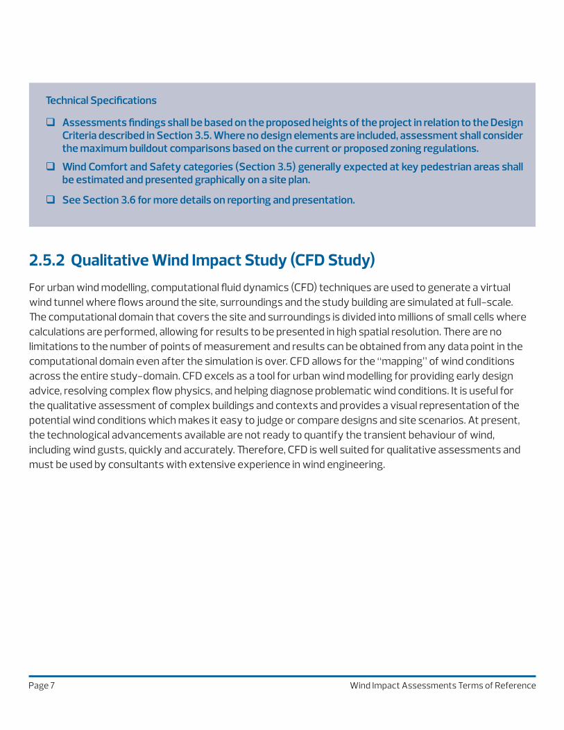
2.5.2 Qualitative Wind Impact Study (CFD Study)For urban wind modelling, computational fluid dynamics (CFD) techniques are used to generate a virtual wind tunnel where flows around the site, surroundings and the study building are simulated at full-scale. The computational domain that covers the site and surroundings is divided into millions of small cells where calculations are performed, allowing for results to be presented in high spatial resolution. There are no limitations to the number of points of measurement and results can be obtained from any data point in the computational domain even after the simulation is over. CFD allows for the “mapping” of wind conditions across the entire study-domain. CFD excels as a tool for urban wind modelling for providing early design advice, resolving complex flow physics, and helping diagnose problematic wind conditions. It is useful for the qualitative assessment of complex buildings and contexts and provides a visual representation of the potential wind conditions which makes it easy to judge or compare designs and site scenarios. At present, the technological advancements available are not ready to quantify the transient behaviour of wind, including wind gusts, quickly and accurately. Therefore, CFD is well suited for qualitative assessments and must be used by consultants with extensive experience in wind engineering.

Page 8 Wind Impact Assessments Terms of Reference
Technical Specifications
� Assessments shall be based on the proposed heights of the project in relation to the Design Criteria described in Section 3.5. Where no design elements are included, assessment shall consider the maximum buildout comparisons based on the current or proposed zoning regulations.
� The CFD software used shall follow the COST 732 Best Practice Guideline for CFD Simulations in an Urban Environment.
� The CFD simulation shall appropriately represent the atmospheric boundary layer for winds approaching the project.
� A minimum of sixteen (16) wind directions at equal intervals shall be simulated. The complete assessment shall consider the probability of all wind directions using meteorological data obtained in accordance with Section 3.4.
� Assessment shall be based on the standard Design Criteria described in Section 3.5.
� Simulation results shall be visualized to represent comfort categories and presented in accordance with the Design Criteria colour coding in Section 3.5.
� The potential wind safety impacts (Section 3.5) shall be estimated through numerical or experience-based methods and areas where an exceedance of the criterion is estimated shall be indicated.
� See Section 3.6 for more details on reporting and presentation.
2.5.3 Quantitative Wind Impact Study (Wind Tunnel Study)Wind tunnel testing is the established tool used for modelling wind flow around buildings and structures in order to quantify and assess wind conditions, among other types of assessments. A scale model of the study area and surroundings are placed in a wind tunnel, instrumented appropriately for wind speed measurements, and subjected to wind flows physically simulated to represent winds approaching the actual site. In general, such modelling provides a good quantified representation of both mean and gust effects and the transient behavior of wind. It is a complex tool and requires experience and expertise to produce useful information and to interpret data, and therefore are accessible only through consultants and universities that specialize in wind engineering.

Page 9 Wind Impact Assessments Terms of Reference
Technical Specifications
� Assessments shall be based on the proposed heights of the project in relation to the Design Criteria described in Section 3.5. Where no design elements are included, assessment shall consider the maximum buildout comparisons based on the current or proposed zoning regulations.
� The wind simulation facility must be capable of simulating the earth’s atmospheric boundary layer and appropriate wind speed and turbulence profiles for each of the wind directions tested.
Wind speed measurement
� 36 wind directions shall be tested.
� Sensors shall be omni-directional and shall measure the magnitude of wind speeds.
� The measurements shall represent the wind speed at a full-scale height of approximately 1.5 m above local grade.
� Sensors and instrumentation shall be capable of measuring mean wind speed and wind speed fluctuations with time, including peak gusts of three to ten second duration. Peak gusts can be directly measured from wind tunnel testing or estimated by “mean wind speeds + 3*RMS” wind speed.
� Sampling time in the wind tunnel shall represent a minimum of one hour of full-scale time and sampling frequency a minimum 1 Hz in full scale.
Sensor placement
� Sensors shall be placed at a full-scale interval of approximately 10 m along street frontages of the project buildings and at all locations where pedestrians will gather. The interval may be increased farther away from the project site.
� Locations shall include all areas of interest in accordance with Section 3.2.
� A typical development project would require a minimum of 50 sensor locations on and around the proposed development to provide adequate coverage.
Analysis and Results
� The analysis shall consider the probability of all wind directions tested using meteorological data obtained in accordance with Section 3.4.
� Assessment shall be based on the Design Criteria in Section 3.5.
� The results shall be presented in both tabular and graphic forms for all the test scenarios, with seasonal comfort and annual safety data. The table must include wind speed and associated comfort and safety category at each measurement location (refer to Section 3.5).
� See Section 3.6 for more details on reporting and presentation.
Page 10 Wind Impact Assessments Terms of Reference
The perception of wind can vary regionally, based on differences in climatic parameters like daylight, temperature, humidity, etc. and parameters like clothing, age, health, and even tolerance to wind developed through acclimatization to the local climate. Therefore, the most objective way to assess the impact of a proposed development on wind conditions around it is to compare it to existing conditions. If the project is expected to result in less than acceptable wind comfort, then further assessments shall be conducted to evaluate a wind mitigation plan that can be implemented in the final design of the project.
The following four scenarios shall be assessed for every project:
- Existing Scenario: Existing site and all existing surrounding buildings, significant topographic features, developments under construction and projects that were approved for construction in the preceding 5 years.
- Proposed Scenario: Proposed project in place of existing site.
- Mitigation Scenario(s), if warranted: Where mitigation is required to achieve acceptable pedestrian wind comfort levels, as concluded from the Proposed Scenario, re-evaluate the Proposed Scenario with recommended mitigation measures in order to demonstrate the benefits of those measures.
- Phasing Scenario(s), if applicable: Where the site construction is phased, there is a need to assess interim scenarios, as well as scenarios that may create adverse conditions before subsequent buildings are added to the site. City Administration may ask for different site configurations.
3.0 TECHNICAL REQUIREMENTSThe requirements specified in the following sections apply to all assessments, regardless of methodology, unless specified otherwise.
3.1 PROJECT CONTEXT SCENARIOS / MASSING SCENARIOS
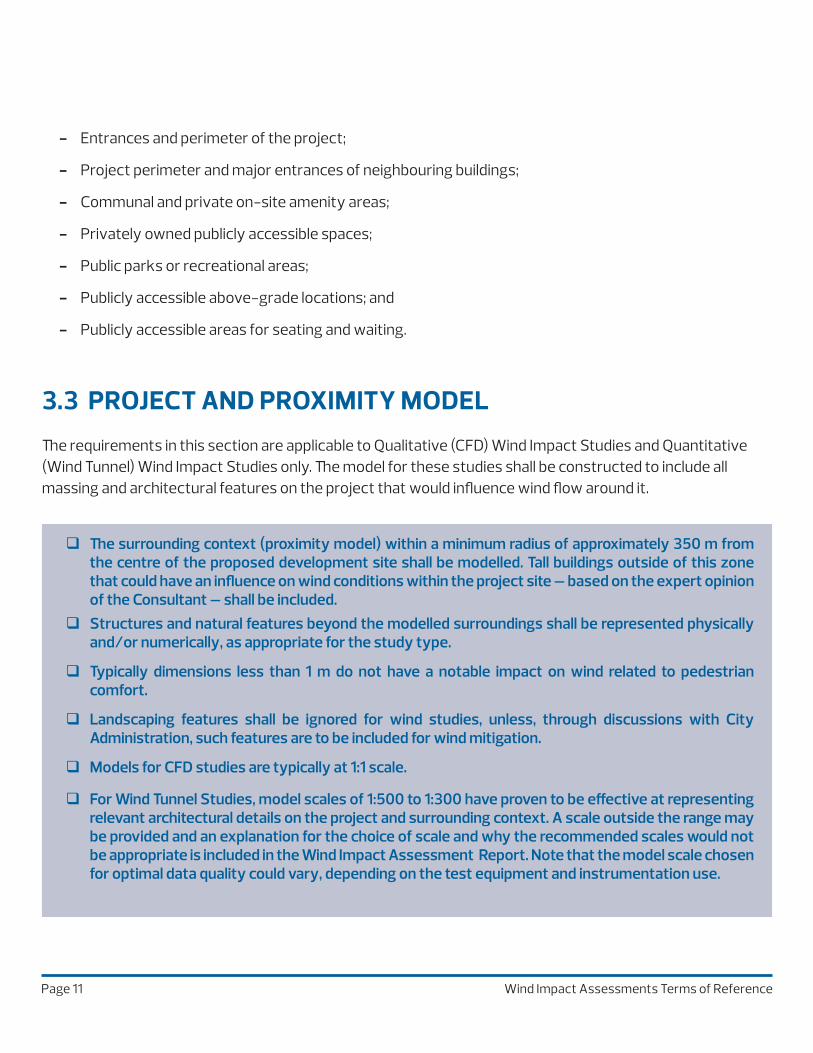
3.2 AREAS OF INTERESTThe scope of the assessment shall be determined by the Consultant and the City, and should cover all key pedestrian areas within a minimum distance equal to the height of the proposed project, measured from the proposed project property line. The distance provided here is a guideline and can vary from project to project based on the form and location of the project. Key pedestrian areas where wind conditions shall be assessed include, but are not limited to:
Page 11 Wind Impact Assessments Terms of Reference
3.3 PROJECT AND PROXIMITY MODEL
The requirements in this section are applicable to Qualitative (CFD) Wind Impact Studies and Quantitative (Wind Tunnel) Wind Impact Studies only. The model for these studies shall be constructed to include all massing and architectural features on the project that would influence wind flow around it.
- Entrances and perimeter of the project;
- Project perimeter and major entrances of neighbouring buildings;
- Communal and private on-site amenity areas;
- Privately owned publicly accessible spaces;
- Public parks or recreational areas;
- Publicly accessible above-grade locations; and
- Publicly accessible areas for seating and waiting.
� The surrounding context (proximity model) within a minimum radius of approximately 350 m from the centre of the proposed development site shall be modelled. Tall buildings outside of this zone that could have an influence on wind conditions within the project site – based on the expert opinion of the Consultant – shall be included.
� Structures and natural features beyond the modelled surroundings shall be represented physically and/or numerically, as appropriate for the study type.
� Typically dimensions less than 1 m do not have a notable impact on wind related to pedestrian comfort.
� Landscaping features shall be ignored for wind studies, unless, through discussions with City Administration, such features are to be included for wind mitigation.
� Models for CFD studies are typically at 1:1 scale.
� For Wind Tunnel Studies, model scales of 1:500 to 1:300 have proven to be effective at representing relevant architectural details on the project and surrounding context. A scale outside the range may be provided and an explanation for the choice of scale and why the recommended scales would not be appropriate is included in the Wind Impact Assessment Report. Note that the model scale chosen for optimal data quality could vary, depending on the test equipment and instrumentation use.
Page 12 Wind Impact Assessments Terms of Reference
3.4 METEOROLOGICAL DATA
The most recent wind records available from Edmonton International Airport shall be used for the assessment of pedestrian wind comfort and safety.
3.5 DESIGN CRITERIA FOR WIND COMFORT AND SAFETY
The pedestrian wind comfort and safety levels are determined by the predicted wind speeds as specified by Table 3, Wind Criteria for Pedestrian Comfort and Safety. The assessment shall consider the predicted comfort and safety levels acceptable for the intended areas of interest as listed under Section 3.2 in relation to the project scenarios listed under Section 3.1.
The proposed development shall demonstrate that wind comfort and safety conditions are acceptable for all areas of interest within the proposed development. For areas of interest located outside the development site, the proposed development shall not worsen comfort and safety conditions beyond the site and shall improve on wind conditions where possible.
Comfort: Commonly experienced wind speeds have been categorized into ranges based on the activity level of a person that the winds would be conducive to. Lower wind speeds are desirable for relaxed activities and active pedestrians would be tolerant of higher wind speeds.
Safety: It is important to assess wind conditions in the pedestrian realm from a safety perspective as strong wind gusts can deter safe pedestrian use of outdoor spaces. Wind speeds associated with such conditions are infrequent but deserve special attention due to their potential impact on pedestrian safety.
� A minimum of 30 years of hourly wind data shall be used.
� The Data is to be presented and used on a two-season basis defined as follows:
� Summer: Hourly winds occurring during the period of May through October.
� Winter: Hourly winds occurring during the period of November through April.
� Appropriate hours of pedestrian usage for a typical project (e.g., between 6:00 and 23:00) shall be considered for wind comfort, while data for 24 hours shall be used to assess wind safety.

Page 13 Wind Impact Assessments Terms of Reference
COMFORTCATEGORY
GEM SPEED (km/h) (2) SEASONAL COMPLIANCE/
MINIMUM OCCURRENCE
(% OF TIME)
DESCRIPTION AREA OF APPLICATIONSUMMERMay-Oct
WINTERNov- Apr (3)
Sitting ≤ 10 ≤ 880% of the time between 6:00 to
23:00
Light breezes desired for outdoor seating areas where one can read a
paper without having it blown away.
Park benches, restaurant seating, balconies, amenity terraces, etc. intended for
relaxed, and usually seated activities.
Standing ≤ 15 ≤ 1280% of the time between 6:00 to
23:00
Gentle breezes suitable for passive pedestrian
activities where a breeze may be tolerated
Main entrances, bus-stops and other outdoor areas
where seated activities can be avoided.
Walking ≤ 20 ≤ 1680% of the time between 6:00 to
23:00
Relatively high speeds that can be tolerated
during intentional walking, running,
cycling and other active movements.
Sidewalks, parking lots, alleyways and areas where
pedestrian activity is infrequent.
Uncomfortable (1) > 20 > 16>20% of the time between 6:00 to
23:00
Strong winds, considered a nuisance for most
activities.
May be accepted in areas not intended for pedestrian
access
(1) The Uncomfortable categorization is applicable if the criteria for Walking are not met.
(2) Gust Equivalent Mean (GEM) speed = maximum of either mean speed or gust speed/1.85. The gust speed can be measured directly from the wind tunnel or estimated as mean speed + (3 x RMS speed).
(3) Threshold wind speeds are lower in the winter to account for wind-chill, in order to consider outdoor comfort in alignment with the Winter Design Guidelines.
SAFETY CRITERION
GUST SPEED(km/h)
ANNUAL COMPLIANCE/MINIMUM OCCURRENCE
(% OF TIME) (4)DESCRIPTION AREA OF APPLICATION
Exceeded > 900.1% of the time
(9 hours in a year)
Excessive gust speeds that can adversely
affect a pedestrian's balance and footing. Wind
mitigation is typically required.
All areas assessed
(4) Wind safety assessment is to be based on wind events recorded for 24 hours a day.
Table 3: Wind Criteria for Pedestrian Comfort and Safety

Page 14 Wind Impact Assessments Terms of Reference
3.6 WIND IMPACT ASSESSMENT REPORTS
� Consultant’s declaration.
� Objectives of the Wind Impact Assessment.
� Brief description of the project (at minimum describe height and location, including a location map).
� Description of the method chosen for the assessment and conformance to the technical requirements of Section 3.0.
� Description of areas of Interest and appropriate comfort and safety level categories intended for each area.
� Description and images of the study and proximity models.
� Description of the source and period of meteorological data use, including a graphical representation of the Meteorological Data (Section 3.4) and Comfort and Safety Criteria (Section 3.5).
Presentation of results
� Wind speeds for each area shall be presented in km/h.
� Results shall correspond to pedestrian level (i.e. approximately 1.5 m above the concerned level).
� For all assessment methodologies, results shall be presented in graphic form for each project scenario (Section 3.1), with a colour coded representation of seasonal comfort and annual safety categories using the colour coding in Table 3 in Section 3.5. Vertical slices or axonometric views depicting flow patterns may be included to understand flow patterns in critical areas.
� For a Quantitative Wind Study, results shall also be presented in tabular forms for each project scenario (Section 3.1), with seasonal comfort data and annual safety data. The table shall include wind speed and associated comfort and safety categorization at each measurement location (refer to Section 3.5).
Discussion of results and recommendations
� Separate discussions for each project scenario (Section 3.1), relating to seasonal comfort and annual safety in accordance with the Design Criteria (Section 3.5).
� The discussion should include interpretation of the results as it relates to the Design Criteria (Section 3.5) discussions about causative flow patterns and recommendations for mitigation of adverse or undesirable wind conditions.
A written report documenting the Wind Impact Assessment and conclusions, shall be provided and include the following:

Page 15 Wind Impact Assessments Terms of Reference
Discussion of results and recommendations (continued)
� Where conditions are predicted to be unacceptable for the intended pedestrian usage, design alternatives and wind control strategies shall be recommended to improve the wind comfort to acceptable levels or appropriate adjustments to pedestrian usage shall be suggested, if applicable.

Page 16 Wind Impact Assessments Terms of Reference
4.0 WIND-RESPONSIVE DESIGN
4.1 WIND FLOW IN THE BUILT ENVIRONMENT
The following is an overview of some of the common wind flow patterns seen in the built environment. One or a combination of such patterns could result in undesirable wind activity in the pedestrian realm, depending on the local climate, building form and its exposure to winds and the surrounding terrain.
When the wind stream is intercepted by the building, some of the flow moves upward and over the building, but
a majority of the stream is redirected downward (downwashing) and around the lower portion of the building.
The wind flow attaches to the building, and then separates at the edges creating high wind activity at the
corners (corner acceleration).
When a short building is located upwind of a taller building, the area between the buildings could be very windy
as a result of the pressure differential between the top and bottom of the building. However, strategic master
planning uses this arrangement to an advantage as locating shorter buildings upwind of taller ones reduces the
exposure of the taller and more impactful buildings to wind, thereby reducing the potential for adverse wind
impacts.
2
1
3
1 2
3 3
WIND FLOW PATTERNS

Page 17 Wind Impact Assessments Terms of Reference
When gaps between buildings, that are narrow relative to the building heights, are aligned with the prevailing
winds, wind accelerates in the gaps because of what's commonly called Venturi effect.
Acceleration is also common under bridges and in underpasses as the air is forced to go through a narrow
passage.
Wind interacts with multiple buildings and the resulting flow is much more complex. Depending on the wind-
rearrangement caused by building groups (or a single building on its own), the causative flow patterns involved
and design flexibility, the choice between "spot-treatments" and measures that have a large-scale impact
becomes critical.
4
5
6
4 5
5 6
WIND FLOW PATTERNS

Page 18 Wind Impact Assessments Terms of Reference
4.2 WIND CONTROL STRATEGIES
The most effective wind control measures involve adjustments to the building early in the design process and relate to the location, orientation, height, massing and form of buildings. Such adjustments are more responsive to the local wind climate. These large-scale modifications can be assisted by features like tower setbacks, large podiums, tower shapes, corner articulations, colonnades/arcades, etc. The following is a description of general large-scale wind-responsive features.
1
2
Building Form - Strategic reshaping of the building can allow wind flow around it to be either more streamlined
(chamfered or rounded corners) or diffused at corners (stepped or re-entrant corners). Low buildings may also
be designed with a stepped form to achieve a similar wind speed reduction. This approach is considered a large-
scale solution that would lower the potential for severe wind impact at grade and has a large area of influence.
Architectural Details - Features such as façade articulations, canopies, covered walkways and recessed
entrances are effective solutions for localized wind mitigation. Recessed walls create areas that will be
protected from ambient wind activity. Recessed entrances and covered walkways provide a protected area for
pedestrians at the base of tall towers that are prone to downwash impacts.
1 1
1 2
WIND-RESPONSIVE DESIGN FEATURES

Page 19 Wind Impact Assessments Terms of Reference
LOCALIZED ACCESSORY ELEMENTS
Smaller-scale measures such as wind screens, public art, landscaping and other localized features can be
considered at an advanced design stage for area-specific wind speed reductions and refinements. The impact of
these features is typically limited to a small area around them.
Wind screens may be placed on both sides of entrances, on sidewalks and in parks and other open spaces to
create localized low wind areas. It is recommended that wind screens be at least 2 m tall and approximately
30% open/porous for good wind control efficacy. Landscaping elements, especially coniferous and marcescent
species, are commonly used to improve wind conditions to appropriate levels, all year round. Deciduous
landscaping is most effective during the summer months. The use of landscaping as part of a mitigation strategy
is acceptable but shall be selected and sized to be effective at the time of installation. Landscaping can only
be recommended as a mitigation measure, where the wind conditions are suitable for it to thrive and for its
maintenance.