WIND AND MOUNTAIN CLIMATOLOGY IN SEVERE …
12
WIND AND MOUNTAIN CLIMATOLOGY IN SEVERE ENVIRONMENTS: SIGNIFICANT DISTURBANCE PATTERNS OF 12-13 NOVEMBER 2011 WIND STORM IN ROCKY MOUNTAIN NATIONAL PARK SELECTED SLIDES D. E. GLIDDEN ORIGINAL WIND RESEARCH STUDIES AVAILABLE AT: http://www.mountwashington.org/education/readings.php?su=edutrips/&sn=EduTrips
Transcript of WIND AND MOUNTAIN CLIMATOLOGY IN SEVERE …

WIND AND MOUNTAIN CLIMATOLOGYIN SEVERE ENVIRONMENTS:
SIGNIFICANT DISTURBANCE PATTERNSOF 12-13 NOVEMBER 2011 WIND STORMIN ROCKY MOUNTAIN NATIONAL PARK
SELECTED SLIDES
D. E. GLIDDEN
ORIGINAL WIND RESEARCH STUDIES AVAILABLE AT:
http://www.mountwashington.org/education/readings.php?su=edutrips/&sn=EduTrips

• DISCUSSION• During late May-early June 2012, RMNP Forester Brain Verhulst and I had a detailed look at the
November 12-13, 2011 wind storm damage in Rocky Mountain National Park. Brian was able todifferentiate the November 12 damage from other events (such as road work, pine beetle cuttingactivities, and other storms). Gathering data on tree-fall directional azimuths, which appear to havegenerally reflected a 230-250 degree (SW-WSW) resultant wind vector for the damage (off theDivide) was useful in identifying some of the characteristics of that particular event. I also had achance earlier to look at some wind damage around Brainard Lake - and met with ARNFsilviculurist Kevin Zimlinghaus. Similarly, the damage there indicated a wind direction of around 250degrees. The influence of man-made open areas in the role of intensifying these events wasnoted, as was the uniquely different characteristics of the Hidden Valley blowdown in 1973...both instrength and crest-level wind direction.
•• The impressive basin-wide damage in Glacier Gorge was noted, and these directional falls also
appeared to reflect a downslope WSW-SW component, rather than a north-south topographicchanneling influence. Hopefully, we will be able to acquire some aerial photographs of this largedisturbance in the future.
•• The November 12-13 storm appears to be more typical of a strong Divide wave at the mountain top
levels (generally associated with strong Pacific fronts), and which then translated into a downslopecomponent, perhaps accelerated by topographical features like Bierstadt Moraine. Limited nearbyBeaver Meadows ROSS wind data indicated gusts to 66 MPH, but due to exposure issues and powerfailure, true canopy-level and alpine winds are likely significantly underrepresented. (This wasevaluated in a separate discussion.) No direct evidence at the surface of convectional downburstswas observed for this event.
•• Although lots of damage occurred along the Front Range, it is still not the same type of event that I
expect to one day re-occur near the Hidden Valley area. During the May 1973 wind storm, theUPPER LEVEL winds were more from the WNW-NW, while Hidden Valley slope winds were morefrom the SW. I believe that the variations are related to significant pressure differences which aretopographically-induced by the great gulf of Hanging Valley and its separation from Hidden Valley –during periods of very high crest-level winds. All of this appears to be critically-dependent on slightchanges in crest-level wind direction, and strong changes (rapid rises or falls) in advective pressuresystems. The more localized, damaging Hidden Valley wind phenomena may be something different,which results from the unique topographical pressure effects in the area. Post-event field work atthe time suggested a more WNW component to airflow crossing the alpine at the time of damage,rather than the SW or WSW flow apparently occurring with the November 12-13 2011 storm.
• The Hidden Valley blowdown – in overall strength, extent, gust factors, and massive crushing – was• a more significant event.

PONDEROSAFALL RIVER BASIN WIND DAMAGE300-320 DEGREESDATE OF DAMAGE UNKNOWN;SUSPECTED TO BE A DIFFERENTSPRING 2012 STORMD. E. GLIDDEN
NEARBY UPROOTED TREE320 DEGREES INDICATEDWIND DIRECTION
310 DEGREES

TUXEDO PARK WIND DAMAGE12-13 NOVEMBER 2011 STORM230-250 DEGREESBRIAN VERHULST, RMNP FORESTER,POSING FOR SCALE
D. E. GLIDDEN
NEARBY UPROOTED TREE230 DEGREES INDICATEDWIND DIRECTION

SPRAGUE LAKE WIND DAMAGEFLOW POSSIBLY COMPRESSED ALONG BIERSTADT MORAINE RIDGE12-13 NOVEMBER 2011 STORM230-250 DEGREESD. E. GLIDDEN
SW NE
NEARBY FRACTURED TREE230 DEGREES INDICATEDWIND DIRECTION

SPRAGUE LAKE WIND DAMAGE12-13 NOVEMBER 2011 STORM230-250 DEGREESD. E. GLIDDEN
BRIAN VERHULST,RMNP FORESTER

SPRAGUE LAKE WIND DAMAGE12-13 NOVEMBER 2011 STORM230-250 DEGREESD. E. GLIDDEN

SPRAGUE LAKE WIND DAMAGE12-13 NOVEMBER 2011 STORM230-250 DEGREESD. E. GLIDDEN

SPRAGUE LAKE WIND DAMAGE12-13 NOVEMBER 2011 STORM230-250 DEGREESD. E. GLIDDEN
VIEW TO SW AND CONTINENTAL DIVIDE
BIERSTADT MORAINE
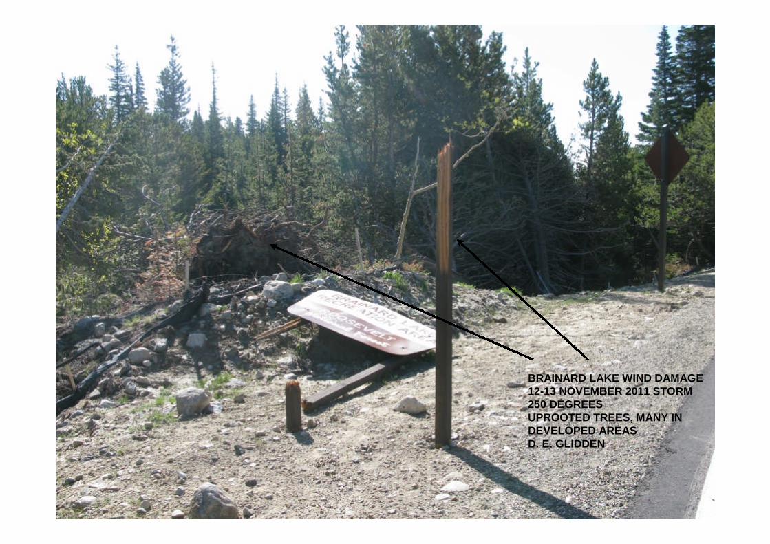
BRAINARD LAKE WIND DAMAGE12-13 NOVEMBER 2011 STORM250 DEGREESUPROOTED TREES, MANY INDEVELOPED AREASD. E. GLIDDEN

APPROXIMATE DIRECTIONOF TREE FALLS FOR1973 BLOWDOWNSW TO NE
APPROXIMATE DIRECTION OF CREST-LEVEL WINDSFOR 1973 BLOWDOWN
FREQUENT WIND DIRECTION AT KNIFE EDGE (TR 2) WITH NW-WNWCREST-LEVEL FLOW, AS MEASURED DURING 1973-74 FIELD STUDIES
THE CREST-LEVEL WIND DIRECTION FOR NOVEMBER 12-13, 2011 WIND STORM APPEARS TO BE SW-WSW, BASED ON MORE SOUTHERLY RAWS STATIONS OUTSIDE RMNP.
N
E
S
D. E. GLIDDEN

LONGS PEAK SUMMIT ON JANUARY 24, 1981MAXIMUM RECORDED PEAK GUST = 161 MPHMAXIMUM 5-MINUTE AVERAGE = 114 MPH
MAXIMUM 1-HOUR AVERAGE = 101 MPHMAXIMUM PEAK GUST RECORDED FOR WINTER 1980-81= 201 MPH
After D. E. Glidden, Winter Wind Studies in Rocky Mountain National Park, 1982
140 KNOTS161 MPH
AVERAGE WIND SPEED90 KNOTS / 103 MPH