Williamsburg VA Bike Trails
24
WILLIAMSBURG BIKING TRAILS www.Williamsburgcc.com
-
Upload
john-womeldorf -
Category
Documents
-
view
232 -
download
4
description
a brief brochure on select bicycle trails throughout the Wiliamsburg VA area
Transcript of Williamsburg VA Bike Trails

WILLIAMSBURGBIKING TRAILS
www.Williamsburgcc.com

When the first English settlers arrived in Jamestownin 1607 they found centuries-old Native Americantrails. These footpaths took them along woodedareas, shorelines, marshlands and fields thatover the past 400 years have seen our American
democracy born and nurtured.
•
Today’s bikers to America’s Historic Trianglecan experience many of those same scenic and
historic trails on leisurely family ridesor rugged mountain bikes.
PAGE 2 . . . . . . . . AMERICA’S HISTORIC TRIANGLE MAP
PAGE 4 . . . . . . . . . . . . . . . . . . . . . HISTORIC WILLIAMSBURG
PAGE 6 . . . . . . . . . . . . . . . . . . . . . . . . COLLEGE LANDING PARK
PAGE 8 . . . . . . . . . . . . . . HISTORIC JAMESTOWNE ISLAND
PAGE 10 . . . . . . . . . . . . . . . . . . . . . . VIRGINIA CAPITAL TRAIL
PAGE 12 . . . . . . . . . . . . . . . . . . . . YORKTOWN BATTLEFIELDS
PAGE 14 . . . . . . . . . . . . . . . . . . . . . LITTLE CREEK RESERVOIR
PAGE 16 . . . . . . . . . . . . . . . . . . THREE COUNTY CHALLENGE
PAGE 18 . . . . . . . . . . . . . . . WILLIAMSBURG WINERY RIDE
PAGE 20 . . . . . . . . . . . . . . . . . . . . . . . . . . . . . . AREA BIKE SHOPS
Table of Contents
• 1 •
Williamsburg Area Bicyclists ClubThis brochure was produced by the Greater Williamsburg
Chamber & Tourism Alliance with the support of
the Williamsburg Area Bicyclists, a club of some 300 local
cyclists whose mission is to “promote and encourage
the use of the bicycle as a means of recreation, fitness and
transportation; encourage the development and utilization
of facilities for bicycling on public lands; and provide
information in the interest of bicycle safety.”•
This brochure contains abbreviated versions of eight of the
popular biking trails with descriptions of the beauty and history
riders will enjoy along the routes. From 18th-century buildings
to timeless wetlands and forests, the sites along each of
these rides will enhance the joy of the journey itself.•
The club has produced an extensive Guide to Cycling
Routes in and around Williamsburg, Virginia. The Guide
provides detailed routing information for 25 rides throughout
the area. For more information regarding the club itself, or
places where you can purchase the Guide, contact the club
at www.wabonline.org, or write to Williamsburg Area
Bicyclists, Box 2222, Williamsburg, VA 23187.•
Both the Alliance and the Bike Club remind you to:
ALWAYS WEAR A HELMETWHEN BIKING
IN THE GREAT OUTDOORS.
• 2 •
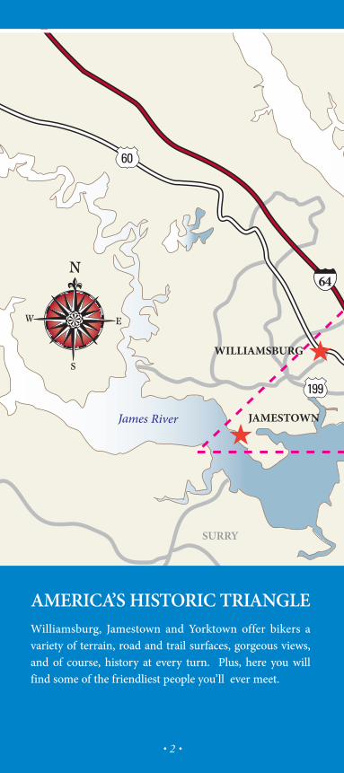
AMERICA’S HISTORIC TRIANGLEWilliamsburg, Jamestown and Yorktown offer bikers avariety of terrain, road and trail surfaces, gorgeous views,and of course, history at every turn. Plus, here you willfind some of the friendliest people you’ll ever meet.

• 3 •
And if you enjoy other outdoor activities, be sureto experience the boating, kayaking, fishing, hiking,jogging, bird watching, or simply walking the manyhistoric paths, forests, and city streets found in America’sHistoric Triangle.
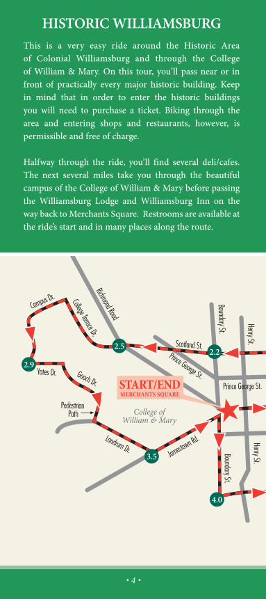
HISTORIC WILLIAMSBURGThis is a very easy ride around the Historic Areaof Colonial Williamsburg and through the Collegeof William & Mary. On this tour, you’ll pass near or infront of practically every major historic building. Keepin mind that in order to enter the historic buildingsyou will need to purchase a ticket. Biking through thearea and entering shops and restaurants, however, ispermissible and free of charge.
Halfway through the ride, you’ll find several deli/cafes.The next several miles take you through the beautifulcampus of the College of William & Mary before passingthe Williamsburg Lodge and Williamsburg Inn on theway back toMerchants Square. Restrooms are available atthe ride’s start and in many places along the route.
• 4 •

DISTANCE: 5.2 MILESTERRAIN: MOSTLY FLAT - WITHIN ANYONE’S CAPABILITYSTARTING POINT: MERCHANTS SQUARE
• 5 •

• 6 •
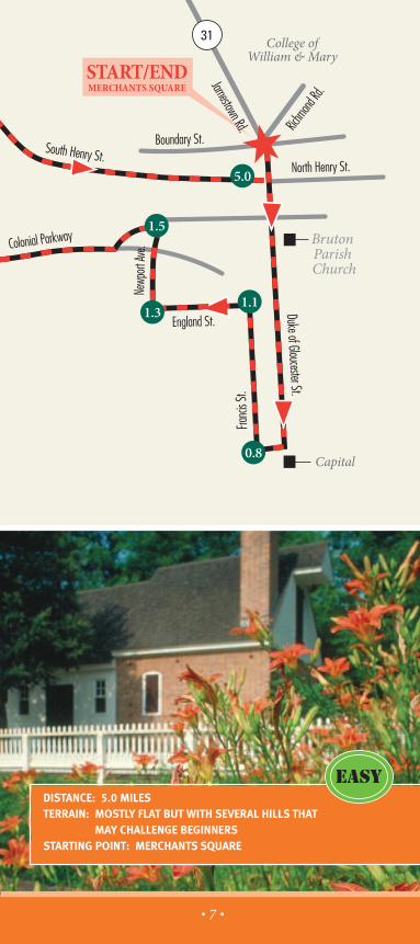
COLLEGE LANDING PARKThis is an easy ride that starts in the Historic Area ofColonial Williamsburg and heads south on the ColonialParkway. Riding on this surface, although rough, is alwaysenjoyable and beautiful, especially in the spring and fall.Just before Rt. 199, you turn off the Parkway and head backtowards Williamsburg on South Henry Street’s bike lane.Turn left off South Henry Street into College Landing Parkand enjoy great views of College Creek. After your break,continue up a short hill on south Henry Street and followthe bike lane back to Merchants Square. Restrooms areavailable at the ride's start.
NOTE: Though labeled "EASY," this ride is not recom-mended for small children due to the rough surface of theColonial Parkway.
• 7 •
DISTANCE: 5.0 MILESTERRAIN: MOSTLY FLAT BUT WITH SEVERAL HILLS THAT
MAY CHALLENGE BEGINNERSSTARTING POINT: MERCHANTS SQUARE
HISTORIC JAMESTOWNEISLAND
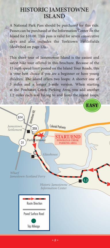
A National Park Pass should be purchased for this ride.Passes can be purchased at the Information Center on theIsland for $10.00. This pass is valid for seven consecutivedays and also includes the Yorktown Battlefields(described on page 12).
This short tour of Jamestowne Island is the easiest andsafest bike tour offered in this brochure. Because of the15 mph speed limit posted on the Island Tour Roads, thisis your best choice if you are a beginner or have youngchildren. The island offers two loops: A shorter one of3 miles and a longer 5-mile version. When startingat the Powhatan Creek Parking Area, you add another1.2 miles each way biking to and from the island loops.
Glasshouse
• 8 •

• 9 •
If you're looking for a shorter length, consider drivinginto the Park and starting at the Historic JamestowneInformation Center (restrooms are available in theCenter). There are glassblowing demonstrations atthe Jamestowne Glasshouse, archeological digs at theoriginal fort site, and interpretive paintings and signsalong the tour roads illustrating early settler life. Trafficis extremely light and cycling is very safe on the island.Be aware, however, of occasional loose gravel. You mightwant to avoid using a road bike with narrow tires.
DISTANCE: 7.4 OR 5.4 MILESTERRAIN: FLATSTARTING POINT: POWHATAN CREEK PARKING AREA, JAMESTOWNE ISLAND
IDEAL FOR FAMILIESWITH YOUNGER CHILDREN

• 10 •

• 11 •
JamestownSettlement
Greensprings Rd.Car Park Area
START/ENDACROSS THE ROADFROM JAMESTOWN
SETTLEMENT ENTRANCE
VIRGINIA CAPITAL TRAILThe Virginia Capital Trail is a pedestrian and bicycle trailthat will ultimately connect Virginia’s past and presentcapitals of Jamestown, Williamsburg and Richmondalong the Scenic Route 5 corridor. The Capital Trailtraverses 50+ miles, five jurisdictions and 400 years richin history along one of the first inland routes in NorthAmerica. Currently, seven miles of paved bike trailwelcome bikers through wooded areas, across deckedbridges with views of pristine wetlands, past the siteof historic Greensprings Plantation. A pleasant andeasy ride for any biker in the family.
DISTANCE: 14 MILESTERRAIN: MOSTLY FLAT WITH A FEW GENTLE HILLSSTARTING POINT: ACROSS THE ROAD FROM JAMESTOWN SETTLEMENTENTRANCE
• 12 •
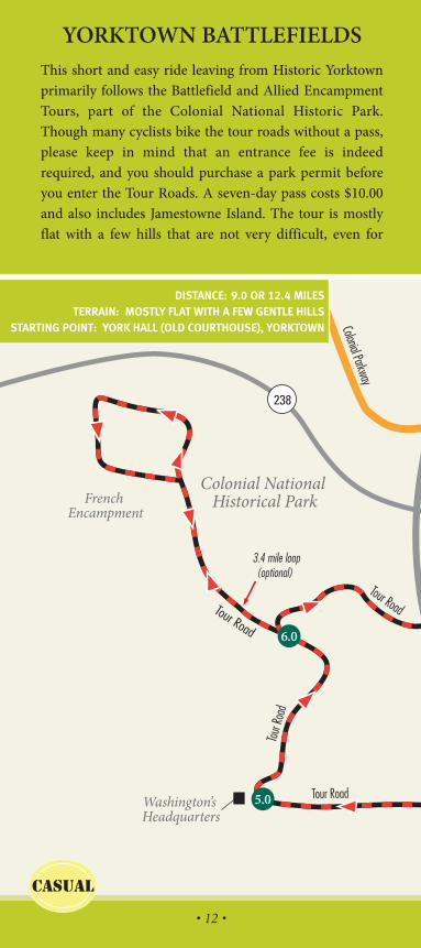
YORKTOWN BATTLEFIELDSThis short and easy ride leaving from Historic Yorktownprimarily follows the Battlefield and Allied EncampmentTours, part of the Colonial National Historic Park.Though many cyclists bike the tour roads without a pass,please keep in mind that an entrance fee is indeedrequired, and you should purchase a park permit beforeyou enter the Tour Roads. A seven-day pass costs $10.00and also includes Jamestowne Island. The tour is mostlyflat with a few hills that are not very difficult, even for
DISTANCE: 9.0 OR 12.4 MILESTERRAIN: MOSTLY FLAT WITH A FEW GENTLE HILLS
STARTING POINT: YORK HALL (OLD COURTHOUSE), YORKTOWN

• 13 •
beginners. Interpretive signs are located all along thetour, offering insight to the Siege of Yorktown, the lastmajor battle of the American Revolution. Various stops arehighlighted on the Park brochure/map, which will makeyour tour of the battlefield area more meaningful. You canpick up your permit and park brochure at the YorktownVisitor Center located just 1/2 mile into the ride. Traffic isextremely light, slow and one-way through most of thistour. Use caution during the short segments along Goosleyand Cook Roads. Restrooms are available at the YorktownVisitor Center.
• 14 •
START/ENDLITTLE CREEK
RESERVOIR PARK
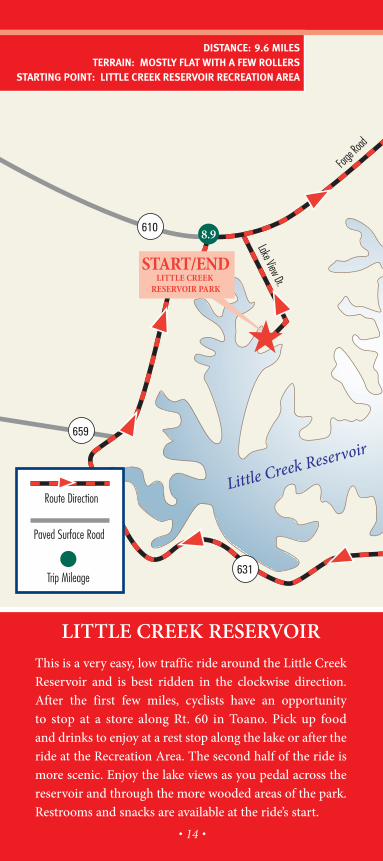
LITTLE CREEK RESERVOIRThis is a very easy, low traffic ride around the Little CreekReservoir and is best ridden in the clockwise direction.After the first few miles, cyclists have an opportunityto stop at a store along Rt. 60 in Toano. Pick up foodand drinks to enjoy at a rest stop along the lake or after theride at the Recreation Area. The second half of the ride ismore scenic. Enjoy the lake views as you pedal across thereservoir and through the more wooded areas of the park.Restrooms and snacks are available at the ride’s start.
DISTANCE: 9.6 MILESTERRAIN: MOSTLY FLAT WITH A FEW ROLLERS
STARTING POINT: LITTLE CREEK RESERVOIR RECREATION AREA

• 15 •

• 16 •

• 17 •
THREE COUNTY CHALLENGEThe Three County Challenge is a rather long and fairlychallenging ride through the rural regions of James City,New Kent and York Counties. Water views of DiascundCreek Reservoir, Goddins Pond, Richardson Mill pond,Barlows Pond, Waller Mill Reservoir, and Little CreekReservoir. Several stores are located along the route as wellas numerous ideal locations for rest stops.
DISTANCE: 55 MILESTERRAIN: MODERATE, WITH HILLS SCATTERED THROUGHOUT THE RIDESTARTING POINT: LITTLE CREEK RESERVOIR RECREATION AREA

WILLIAMSBURG WINERY RIDEStarting in the Historic Area, the Williamsburg WineryRide is an easy spin down to the James River via theColonial Parkway. There are a few manageable, small hillson the Parkway, and the road surface is a bit rough forsmall children. When you reach the James River at mile3.5, consider a stop at the beach area on the left side of theParkway. Pay close attention to your odometer for theturnoff to Treasure Island Road. At mile 5.7 you’ll turnRIGHT on the signed bike path which you’ll follow about100 yards until it ends at Treasure Island Road. A stop atthe Williamsburg Winery is always pleasant. Use cautionon Jamestown road when crossing Rt. 199 on your wayback to Merchants Square. Restrooms are available atthe ride’s start and at the Williamsburg Winery.
DISTANCE: 12 MILESTERRAIN: MOSTLY FLAT WITH A FEW GENTLE HILLS
STARTING POINT: MERCHANTS SQUARE
• 18 •

• 19 •

Greater Williamsburg Chamber & Tourism Alliance
Member Bike Shops.
Conte’s Bicycle & Fitness Equipment
New Town Center
4919 Courthouse St.
Williamsburg, VA 23188
Phone: 757.565.1225
• 20 •

WWW.WILLIAMSBURGCC.COM

Greater Williamsburg Chamber and Tourism AlliancePost Office Box 3495 • Williamsburg VA 23187-3495
800.368.6511 • 757.229.6511 • Fax 757.253.1397www.Williamsburgcc.com