Wildlife Big Bend Watching Ranch SP Page 12 el … objects (like your vehicle) as blinds. • Avoid...
12
TEXAS PARKS AND WILDLIFE Geology at the Crossroads Page 10 Table of contents El Solitario is published twice per year by the Texas Parks and Wildlife Department for the orientation and education of visitors to Big Bend Ranch State Park. Wildlife Watching Page 1 Fresno-Sauceda Loop Trail - “Epic” ride 2 Be Aware 3 Featured Campsites 3 Featured Hike 4 Featured Mountain Biking 4 Fees and Visitor Services 5 Big Bend Ranch State Park Map 6 Access and Visitor Services 8 Limited Time? 9 Geology at the Crossroads 10 The Madrid House: Squatters Ruled 11 Raft the Rio Grande 12 el S O LitarIo Raft the Rio Grande Page 12 Big Bend Ranch SP pullout map Pages 6 — 7 By Linda Hedges During your visit to Big Bend Ranch, be on the lookout for the park’s diverse and plentiful wildlife. From mule deer to javelina, gray foxes to rock squirrels, red-tailed hawks to coyotes, you are sharing the park with dozens of interesting species. Get to know them safely and responsibly during your stay by adhering to the following guidelines, adapted from Watching Wildlife by Mark Damian Duda. Look in the right place. An animal’s habitat consists of the food, water, shelter and space that it needs to survive. In a desert environment like Big Bend Ranch, many types of wildlife depend heavily on water resources and vegetated areas such as arroyos. Both are excellent places to look for wildlife. Also remember that some species literally live on the edge--where two different habitats meet, that is. Be sure to scan these transitional areas. Look at the right time. Some animals, such as songbirds, hawks and rock squirrels are active during the day (diurnal). Other species, such as owls and bobcats, are active at night (nocturnal). In general, early mornings and evenings are the best times to view most birds and large mammals, such as mule deer, when they are most active. TEXAS PARKS AND WILDLIFE DEPARTMENT | WINTER/SPRING 2011 | BIG BEND RANCH STATE PARK Develop wildlife-viewing skills. While looking for wildlife, really focus your eyes and tune in your ears: • Look for subtle movements in the landscape and listen for animal sounds. • Look for parts of an animal, rather than its entire body. • Look above and below you, not just straight ahead. Animals occupy niches of all the vertical and horizontal layers of a habitat. • Look for out-of-place shapes, such as a round shape on a linear tree branch. • Avoid sudden movements. The animal you are watching likely considers you a predator. Use natural objects (such as boulders or shrubs) or man-made objects (like your vehicle) as blinds. • Avoid staring at animals; wear a hat that conceals your eyes. • Avoid sneaking up on animals. Rather, maintain a safe distance and use binoculars for a closer look. Understand the species and its habits. Learning to identify wildlife accurately is a lifelong process. Nothing will help you more than a good set of field guides (available at the park store) and binoculars. Carefully observe size, color, shape, habitat, vocal- izations, and behaviors. Don’t just look at wildlife – learn to observe it. What is the animal doing and why? Try to understand what you are seeing and hearing within the context of the habitat. (cont. on page 2) Wildlife Watching Photo: © E. Dan Klepper
-
Upload
nguyenkhanh -
Category
Documents
-
view
213 -
download
1
Transcript of Wildlife Big Bend Watching Ranch SP Page 12 el … objects (like your vehicle) as blinds. • Avoid...
T E X A S P A R K S A N D W I L D L I F E
Geologyat the CrossroadsPage 10
Table ofcontents
El Solitario is published twice per year by the Texas Parks and Wildlife Department for the orientation and education of visitors to Big Bend Ranch State Park.
Wildlife WatchingPage 1
Fresno-Sauceda Loop Trail - “Epic” ride . . . . . . 2
Be Aware . . . . . . . . . . . . . . . . . . . . . . . . . . . . . . . . . 3
Featured Campsites . . . . . . . . . . . . . . . . . . . . . . . . 3
Featured Hike . . . . . . . . . . . . . . . . . . . . . . . . . . . . . 4
Featured Mountain Biking . . . . . . . . . . . . . . . . . . . 4
Fees and Visitor Services . . . . . . . . . . . . . . . . . . . 5
Big Bend Ranch State Park Map . . . . . . . . . . . . 6
Access and Visitor Services . . . . . . . . . . . . . . . . 8
Limited Time? . . . . . . . . . . . . . . . . . . . . . . . . . . . . 9
Geology at the Crossroads . . . . . . . . . . . . . . . . 10
The Madrid House: Squatters Ruled . . . . . . . . . 11
Raft the Rio Grande . . . . . . . . . . . . . . . . . . . . . . 12
el SOLitarIoRaft the Rio GrandePage 12
Big Bend Ranch SP pullout mapPages 6 — 7
By Linda Hedges
During your visit to Big Bend Ranch, be on the lookout for the park’s diverse and plentiful wildlife. From mule deer to javelina, gray foxes to rock squirrels, red-tailed hawks to coyotes, you are sharing the park with dozens of interesting species. Get to know them safely and responsibly during your stay by adhering to the following guidelines, adapted from Watching Wildlife by Mark Damian Duda.
Look in the right place.
An animal’s habitat consists of the food, water, shelter and space that it needs to survive. In a desert environment like Big Bend Ranch, many types of wildlife depend heavily on water resources and vegetated areas such as arroyos. Both are excellent places to look for wildlife. Also remember that some species literally live on the edge--where two different habitats meet, that is. Be sure to scan these transitional areas.
Look at the right time.
Some animals, such as songbirds, hawks and rock squirrels are active during the day (diurnal). Other species, such as owls and bobcats, are active at night (nocturnal). In general, early mornings and evenings are the best times to view most birds and large mammals, such as mule deer, when they are most active.
T e x a s P a r k s a n d W i l d l i f e d e P a r T m e n T | W i n T e r / s P r i n G 2 0 1 1 | B i G B e n d r a n c h s T a T e P a r k
Develop wildlife-viewing skills.
While looking for wildlife, really focus your eyes and tune in your ears:
• Look for subtle movements in
the landscape and listen for
animal sounds.
• Look for parts of an animal,
rather than its entire body.
• Look above and below you, not just straight ahead. Animals occupy niches of all the vertical and horizontal layers of a habitat.
• Look for out-of-place shapes, such as a round shape on a linear tree branch.
• Avoid sudden movements. The animal you are watching likely considers you a predator. Use natural objects (such as boulders or shrubs) or man-made objects (like your vehicle) as blinds.
• Avoid staring at animals; wear a hat that conceals your eyes.
• Avoid sneaking up on animals. Rather, maintain a safe distance and use binoculars for a closer look.
Understand the species and its habits.
Learning to identify wildlife accurately is a lifelong process. Nothing will help you more than a good set of field guides (available at the park store) and binoculars. Carefully observe size, color, shape, habitat, vocal-izations, and behaviors. Don’t just look at wildlife – learn to observe it. What is the animal doing and why? Try to understand what you are seeing and hearing within the context of the habitat. (cont. on page 2)
Wildlife Watching
Phot
o: ©
E. D
an K
lepp
er
2 | el SOLitarIo | Texas parks and wildlife department
Fresno-Sauceda Loop Trail designated an “Epic” ride
The Fresno – Sauceda Loop Trail winds through recently opened Fresno Canyon in the eastern section of the park with frequent climbs and sometimes steep descents. Parts of the trail are single-track, and other sections are double-track 4x4 roads. In addition to spectacular scenery, the trail winds past abandoned cinnabar mines, desert springs, turn-of-the century ranch ruins, deserted homesteads and Native American pictograph sites.
Texas Parks and Wildlife staff writer Karen Hoffman Blizzard, who wrote of her experience in the November 2009 issue of Texas Parks and Wildlife magazine, calls the trail “the quintessential Epic ride. It takes you out of the ordinary and into the Zone.”
T E X A S S T A T E P A R K S
EarlN
otting
ham
THE OTHER SIDE OF NOWHERE
BIG BEND RANCHBIking guide
(cont. from page 1)
Wildlife Calling Cards: Tracks and Signs
You don’t always have to see wildlife to enjoy wildlife; animals often leave clues about their movements and daily routines. Scat can reveal an animal’s diet, so don’t be afraid to look. Remains of other animals (in carnivores), plants (in herbivores) or both (in omnivores) may be discernable. Look for whitewash (bird droppings) on cliffs and beneath trees to signal the presence of a roost or possible nest site. Watch for owl pellets under trees and utility poles, where these nighttime hunters regurgitate indigestible bone and fur. Look for narrow animal trails that mark routes to food, water or shelter. Notice the marks left on small tree trunks from antler rubbing or gnawing by mule deer.
Observe animal tracks in soft ground or mud. Skunks and raccoons walk flat-footed, whereas gray foxes and coyotes walk on their toes, leaving behind claw marks. Mountain lions and bobcats also walk on their toes, but typically with retracted claws. Mule deer and javelina leave distinctive hoof marks, whereas rabbit tracks are laid down in sets of three.
Mule deer tend to prefer arid, open habitat. Watch for them traversing rocky hillsides during the morning and early evening hours.
Javelina occupy brushy areas with abundant prickly pear, where they are active mainly in early morning and late afternoon. These animals often bed down in dense brush during the heat of the day.
Less common that its cousin the Scaled Quail, Gambel’s Quail is found primarily along the Rio Grande corridor. Look for its tell-tale
crown feather--a forward curling topknot, and listen carefully for its cry-like call.
IF YOU GO Water requirements: 200 – 220 ounces of water per day while riding (the equivalent of two large Camelbacks)
Plan ahead of time: Get your bike and gear together, and arrange guide services and SAG support . Hard-soled shoes are recommended for walking in rocky arroyos and creek beds . A GPS unit is helpful . ALWAYS CARRY TWO SPARES.
Maps and trail guides: Visit the TPWD website (www .tpwd .state .tx .us) before your trip . Online map sources include Google Earth, USGS (www .usgs .gov) and TNRIS maps (www .tnris .state .tx .us) .
Commercial outfitters: Terlingua-based Desert Sports (432-371-2489) is the nearest outfitter and guide service . SAG and guide support are highly recommended for multi-day trips through the park . Bikes are available for rent at commercial outfitters and at the park .
Access and Lodging: Information about access, park lodging and camping may be found on pages 5 & 8 of this publication . Offsite, Lajitas Resort and Spa (www .lajitas .com) offers 103 rooms, a restaurant and other amenities . Chinati Hot Springs (www .chinatihotsprings .com) offers cabins, a community kitchen, spring-fed hot pools, and a “cool pool .”
LINKS:
The Epic ride is a variation of Ride #23 in the Big Bend Ranch Biking Guide . The guide is available on the TPWD website at www.tpwd.state.tx.us/spdest/findadest/parks/big_bend_ranch/ and at Big Bend Ranch State Park .
The IMBA Epic ride description is at www.imba.com/epics/fresno-sauceda-loop
The TPW magazine article describing the Epic ride is at www.tpwmagazine.com/archive/2009/nov/ed_1/
Ear
l Not
ting
ham
ern U.S. Epics are selected by IMBA staff, including their regional directors, who decide which trails in their area are having the largest influence on riders, land managers and decision makers. IMBA board member and Mountain Bike Hall of Fame inductee Hill Abell describes the Fresno – Sauceda trail as “a huge day in the saddle and super challenging.”
The International Mountain Biking Association (IMBA) has designated the Fresno – Sauceda Loop Trail at Big Bend Ranch State Park an “Epic” ride. IMBA has designated fewer than 50 Epic rides in the U.S. and Canada. The Big Bend Ranch SP designation is the only mountain-bike ride designated as Epic in the state of Texas, and only one of two in the southwest-
big bend ranch state park | el SOLitarIo | 3
Many wonderful animals live here and play a vital role in the balance of nature. You are a guest in their home. By learning about the park’s animals and observing the following tips, you can show them the respect they deserve while keeping yourself and your family safe.
Rattlesnakes are especially common at Big Bend Ranch. Watch where you put your hands and feet. Never harass or attempt to handle a rattlesnake—this is when most bites occur. Rattlesnakes are protected in the park; do them no harm.
Never feed wild animals or allow them to get human or pet food.
Observe wild animals and longhorn cattle from a safe distance; never approach or try to photograph them at close range.
Keep children and pets under your control at all times.
Clean up and store food and garbage immediately after meals; never keep food in your tent.
Enjoy the outdoors with others, not alone.
In the unlikely event that you encounter a black bear or mountain lion, do not run. Instead, face the animal, make noise and try to look as large as possible. Pick up small children. Back away slowly. If attacked, fight back. Report sightings to park staff immediately.
BE AWARE:For your safety and welfare
Western Diamondback
rattlesnake
Ear
l N
otti
ngh
am
In the unlikely event that a snake bite occurs:
• Remove jewelry and loosen tight-fitting clothing .
• Wash the bite area with disinfectant .
• Keep the person calm and quiet .
• Limit movement if at all possible .
• Watch for symptoms of shock .
• Seek medical attention immediately .
+
Head ‘em up, move ‘em out!Weekend wranglers have a chance each spring and fall to participate in the Park’s cattle drive, when the Texas Longhorn herd is moved with horses from remote pastures to stock pens at Sauceda. This three-day event includes ranch-style food and accommodations, plus plenty of time in the saddle.
Surrounded by ancient lava beds, scenic campsites are located adjacent to the historic Marfa-Terlingua Road in the Upper Fresno Backcountry Zone. They are protected from strong winds by rocky outcroppings, but maintain an open, spacious feeling. The campsites’ namesake, Pila Montoya, is a metal water tank found 7.5 miles east of Sauceda.
Featured Campsites
Pila Montoya 2 & 3
UTM 13 Easting: 610427 .540
UTM13 Northing: 3263474 .333
Longitude DD: -103 .86080
Latitude DD: 29 .49594
Longitude DMS: -103 51 38 .89Latitude DMS: 29 29 45 .39
GPS CoordinatesPila Montoya 2
Access:
2WDHigh clearance
Sauceda to Pila Montoya Road: 7 .5 miles
To Pila Montoya 2: 1 .0 mile
To Pila Montoya 3: 1 .4 miles
Getting There
What’s special about these sites?• Silence and solitude• Great launching points for day hikes• Excellent stargazing
Spring cattle drive: April 21, 22 & 23For information, call the Sauceda Ranger Station at (432) 358-4444 .
Pila Montoya 2 & 3 can each accommodate up to eight people, and they feature a picnic table, fire ring, and at least two tent pads. A maximum of three cars is allowed in the parking area.
If a secluded atmosphere is on your agenda, these sites are a perfect choice. Some say that you can still hear the horses and mules of the stagecoach and freight wagons struggling up the steep incline of the old freight road as it climbs out of Fresno Canyon.
UTM 13 Easting: 610558 .200
UTM13 Northing: 3263093 .233
Longitude DD: -103 .85949
Latitude DD: 29 .49249
Longitude DMS: -103 51 34 .18
Latitude DMS: 29 29 32 .97
GPS CoordinatesPila Montoya 3
Ear
l Not
ting
ham
Bar
rett
Dur
stB
arre
tt D
urst
4 | el SOLitarIo | Texas parks and wildlife department
Contrabando Multi-use Trail has two trailheads, one located directly
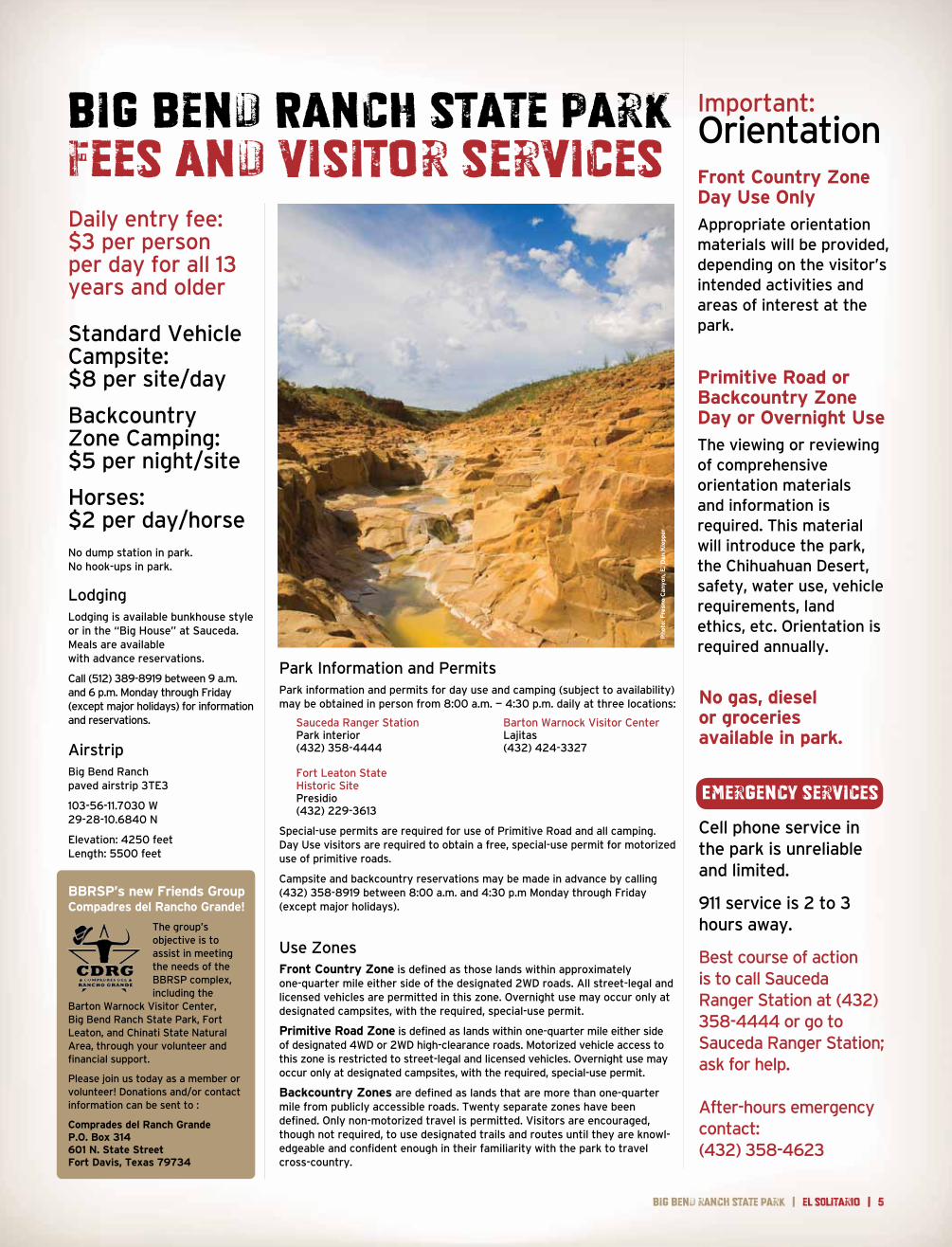
across the highway from the Barton Warnock Visitor Center near Lajitas and a second located 7.5 miles to the west along F.M. 170. Regardless of your skill level, this 25-mile trail system offers a segment or side loop that is suitable for you — from novice to advanced. Watch for horses: this trail is open to equestrians too. Enjoy spectacular views as you encircle the red rock of Lajitas Mesa or the uplifted Contrabando Dome. Along the trail, watch for wayside exhibits that interpret the area’s mining and ranching heritage.
The word “contrabando” is Spanish for “contraband.” For decades, smugglers traversed what is now known as the Contrabando region along the eastern boundary of Big Bend Ranch State Park. In the early 1900s, area ranchers sought Mexican cattle to bolster their herds; some brought animals across the border illegally to avoid custom fees. During the 1930s, huge amounts of candelilla wax slipped across the border as well. Wax smugglers escaped heavy Mexican export taxes and profited from higher prices in the U.S. Then, during prohibition, mule trains brought great quantities of sotol, an
MOUNTAIN BIKINGContrabando Multi-use Trail 25 miles
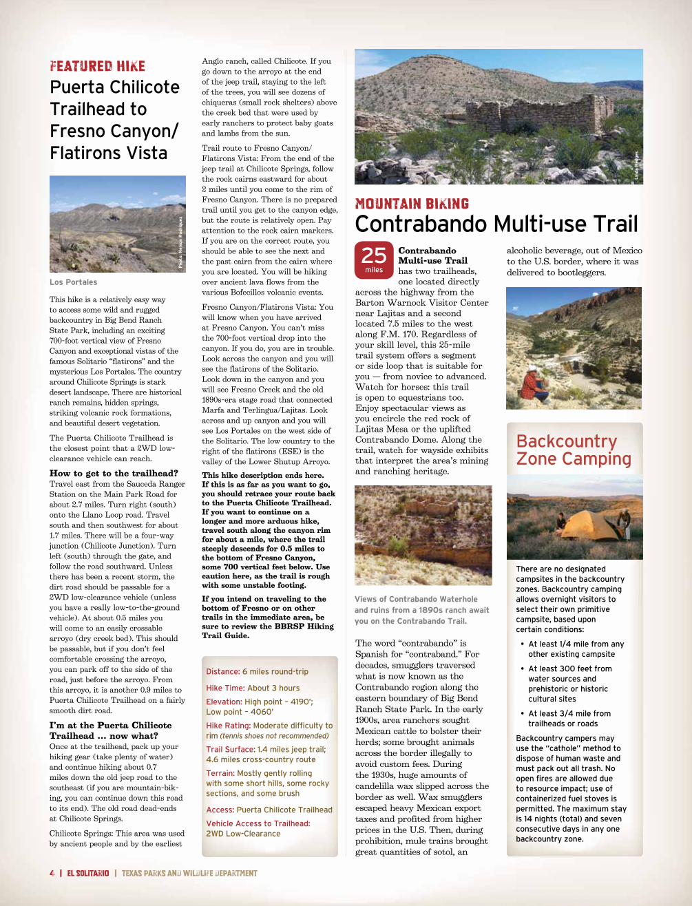
FEATURED HIKEPuerta Chilicote Trailhead to Fresno Canyon/Flatirons Vista
Backcountry Zone Camping
There are no designated campsites in the backcountry zones . Backcountry camping allows overnight visitors to select their own primitive campsite, based upon certain conditions:
• At least 1/4 mile from any other existing campsite
• At least 300 feet from water sources and prehistoric or historic cultural sites
• At least 3/4 mile from trailheads or roads
Backcountry campers may use the “cathole” method to dispose of human waste and must pack out all trash . No open fires are allowed due to resource impact; use of containerized fuel stoves is permitted . The maximum stay is 14 nights (total) and seven consecutive days in any one backcountry zone .
Views of Contrabando Waterhole and ruins from a 1890s ranch await you on the Contrabando Trail.
This hike is a relatively easy way to access some wild and rugged backcountry in Big Bend Ranch State Park, including an exciting 700-foot vertical view of Fresno Canyon and exceptional vistas of the famous Solitario “flatirons” and the mysterious Los Portales. The country around Chilicote Springs is stark desert landscape. There are historical ranch remains, hidden springs, striking volcanic rock formations, and beautiful desert vegetation.
The Puerta Chilicote Trailhead is the closest point that a 2WD low-clearance vehicle can reach.
How to get to the trailhead?Travel east from the Sauceda Ranger Station on the Main Park Road for about 2.7 miles. Turn right (south) onto the Llano Loop road. Travel south and then southwest for about 1.7 miles. There will be a four-way junction (Chilicote Junction). Turn left (south) through the gate, and follow the road southward. Unless there has been a recent storm, the dirt road should be passable for a 2WD low-clearance vehicle (unless you have a really low-to-the-ground vehicle). At about 0.5 miles you will come to an easily crossable arroyo (dry creek bed). This should be passable, but if you don’t feel comfortable crossing the arroyo, you can park off to the side of the road, just before the arroyo. From this arroyo, it is another 0.9 miles to Puerta Chilicote Trailhead on a fairly smooth dirt road.
I’m at the Puerta Chilicote Trailhead … now what?Once at the trailhead, pack up your hiking gear (take plenty of water) and continue hiking about 0.7 miles down the old jeep road to the southeast (if you are mountain-bik-ing, you can continue down this road to its end). The old road dead-ends at Chilicote Springs.
Chilicote Springs: This area was used by ancient people and by the earliest
Anglo ranch, called Chilicote. If you go down to the arroyo at the end of the jeep trail, staying to the left of the trees, you will see dozens of chiqueras (small rock shelters) above the creek bed that were used by early ranchers to protect baby goats and lambs from the sun.
Trail route to Fresno Canyon/Flatirons Vista: From the end of the jeep trail at Chilicote Springs, follow the rock cairns eastward for about 2 miles until you come to the rim of Fresno Canyon. There is no prepared trail until you get to the canyon edge, but the route is relatively open. Pay attention to the rock cairn markers. If you are on the correct route, you should be able to see the next and the past cairn from the cairn where you are located. You will be hiking over ancient lava flows from the various Bofecillos volcanic events.
Fresno Canyon/Flatirons Vista: You will know when you have arrived at Fresno Canyon. You can’t miss the 700-foot vertical drop into the canyon. If you do, you are in trouble. Look across the canyon and you will see the flatirons of the Solitario. Look down in the canyon and you will see Fresno Creek and the old 1890s-era stage road that connected Marfa and Terlingua/Lajitas. Look across and up canyon and you will see Los Portales on the west side of the Solitario. The low country to the right of the flatirons (ESE) is the valley of the Lower Shutup Arroyo.
This hike description ends here. If this is as far as you want to go, you should retrace your route back to the Puerta Chilicote Trailhead. If you want to continue on a longer and more arduous hike, travel south along the canyon rim for about a mile, where the trail steeply descends for 0.5 miles to the bottom of Fresno Canyon, some 700 vertical feet below. Use caution here, as the trail is rough with some unstable footing.
If you intend on traveling to the bottom of Fresno or on other trails in the immediate area, be sure to review the BBRSP Hiking Trail Guide.
Los Portales
Phot
o: N
elso
n R
odri
guez
Distance: 6 miles round-trip
Hike Time: About 3 hours
Elevation: High point – 4190’; Low point – 4060’
Hike Rating: Moderate difficulty to rim (tennis shoes not recommended)
Trail Surface: 1 .4 miles jeep trail; 4 .6 miles cross-country route
Terrain: Mostly gently rolling with some short hills, some rocky sections, and some brush
Access: Puerta Chilicote Trailhead
Vehicle Access to Trailhead: 2WD Low-Clearance
alcoholic beverage, out of Mexico to the U.S. border, where it was delivered to bootleggers.
Lin
da H
edge
s
big bend ranch state park | el SOLitarIo | 5
Daily entry fee: $3 per person per day for all 13 years and older
Standard Vehicle Campsite: $8 per site/day
Backcountry Zone Camping: $5 per night/site
Horses: $2 per day/horseNo dump station in park . No hook-ups in park .
LodgingLodging is available bunkhouse style or in the “Big House” at Sauceda . Meals are available with advance reservations .
Call (512) 389-8919 between 9 a .m . and 6 p .m . Monday through Friday (except major holidays) for information and reservations .
AirstripBig Bend Ranch paved airstrip 3TE3
103-56-11 .7030 W 29-28-10 .6840 N
Elevation: 4250 feet Length: 5500 feet
Park Information and PermitsPark information and permits for day use and camping (subject to availability) may be obtained in person from 8:00 a .m . — 4:30 p .m . daily at three locations:
Sauceda Ranger Station Barton Warnock Visitor Center Park interior Lajitas (432) 358-4444 (432) 424-3327 Fort Leaton State Historic SitePresidio (432) 229-3613
Special-use permits are required for use of Primitive Road and all camping . Day Use visitors are required to obtain a free, special-use permit for motorized use of primitive roads .
Campsite and backcountry reservations may be made in advance by calling (432) 358-8919 between 8:00 a .m . and 4:30 p .m Monday through Friday (except major holidays) .
Use ZonesFront Country Zone is defined as those lands within approximately one-quarter mile either side of the designated 2WD roads . All street-legal and licensed vehicles are permitted in this zone . Overnight use may occur only at designated campsites, with the required, special-use permit .
Primitive Road Zone is defined as lands within one-quarter mile either side of designated 4WD or 2WD high-clearance roads . Motorized vehicle access to this zone is restricted to street-legal and licensed vehicles . Overnight use may occur only at designated campsites, with the required, special-use permit .
Backcountry Zones are defined as lands that are more than one-quarter mile from publicly accessible roads . Twenty separate zones have been defined . Only non-motorized travel is permitted . Visitors are encouraged, though not required, to use designated trails and routes until they are knowl-edgeable and confident enough in their familiarity with the park to travel cross-country .
Big Bend Ranch State ParkFees and visitor services
Important:OrientationFront Country Zone Day Use Only
Appropriate orientation materials will be provided, depending on the visitor’s intended activities and areas of interest at the park .
Primitive Road or Backcountry Zone Day or Overnight Use
The viewing or reviewing of comprehensive orientation materials and information is required . This material will introduce the park, the Chihuahuan Desert, safety, water use, vehicle requirements, land ethics, etc . Orientation is required annually .
No gas, diesel or groceriesavailable in park.
Cell phone service in the park is unreliable and limited .
911 service is 2 to 3hours away .
Best course of action is to call Sauceda Ranger Station at (432) 358-4444 or go to Sauceda Ranger Station; ask for help .
After-hours emergency contact:(432) 358-4623
Emergency services
Phot
o: F
resn
o C
anyon
, E. D
an K
lepp
er
BBRSP’s new Friends GroupCompadres del Rancho Grande!
The group’s objective is to assist in meeting the needs of the BBRSP complex, including the
Barton Warnock Visitor Center, Big Bend Ranch State Park, Fort Leaton, and Chinati State Natural Area, through your volunteer and financial support .
Please join us today as a member or volunteer! Donations and/or contact information can be sent to :
Comprades del Ranch GrandeP.O. Box 314601 N. State StreetFort Davis, Texas 79734
Big
Bend
ran
chSt
ate P
ark

8 | el SOLitarIo | Texas parks and wildlife department
Know Your VehicleSome roads are suitable only for high-clearance or four-wheel-drive vehicles . If you have any questions about the roads or the suitability of your vehicle, consult a park ranger .
• Two-wheel-drive (2WD): main road and some spurs that any highway- worthy vehicle, driven responsibly, can access .
• Two-wheel-drive, high-clearance (2WDHC): roads where extra clearance is required due to road conditions (rocks, steep dips, etc .) .
• Four-wheel-drive (4WD): recommended where extra traction is required on steep, loose or soft ground . Includes all-wheel drive (AWD) .
• Four-wheel-drive, high-clearance (4WDHC): primitive roads or routes harsher then 4WD, where passage requires vehicles with extra traction, rigid suspension and high clearance .
High clearance is considered a minimum of 8 inches .
Rules for the Road Less TraveledPark roads are dirt and may be narrow . Speed limit is 25 mph on primary park roads . Drive slowly to keep yourself, your passengers, your vehicle and the park’s animals safe .
When should 4WD be engaged? Generally speaking, once you leave the maintained road, shift from 2WD into 4WD and leave it there until returning to the maintained road . Use 4WD low before you need to negotiate any really difficult obstacles .
Take care of your tires . On primitive roads, the number one trouble is tire failure, often sidewall punctures . Drive slowly and watch for sharp rocks, sticks and cactus . Carry fix-a-flat, a lug wrench, hydraulic jack and tow strap . A good spare is essential; two spares are recommended .
Always carry an extra 5 gallons of water.
Beware of brush . The woody bushes of the desert are extremely hard and can produce nasty scratches in your vehicle’s paint .
NOTE: A special-use permit is required for travel on all BBRSP roads 2WDHC and beyond.
Big Bend Ranch State ParkAccess and visitor servicesVehicle-Accessible CampingForty-nine locations have been designated for vehicle-accessible camping . Permits are required . Each site includes a tent area, picnic table and fire ring . Some campsites are still under development and may temporarily lack some amenities .
Campers are required to place tents in designated areas only . Desert resources are fragile . Important: All visitors are required to haul out their human waste and pack out all trash.
Portable privies are available for purchase at all permit-issuing stations .
Downed wood is critical to desert ecology . Gathering firewood is prohibited . Visitors may bring their own firewood or purchase it at Sauceda . Charcoal cooking fires and containerized fuel stoves are allowed . Ashes must be packed out or deposited in the fire ring . The maximum stay per permit is 14 nights .
Individual Campsites
• Up to 8-person occupancy • 3-vehicle limit
Group Campsites
• Up to 12-person occupancy • 5-vehicle limit
Equestrian Staging Campsites
• Up to 24-person occupancy • 12-vehicle limit
Campsites at Campgrounds
• 3-vehicle limit
PetsPets are allowed anywhere vehicles are allowed, and within 1/4 mile of publicly accessible roads . Always keep pets on a leash and pick up after them . Never leave pets unattended or allow them to approach wild animals or longhorn cattle .
Food and LodgingThe lodge at Sauceda is a bunkhouse with a commercial kitchen . Meals are prepared and served in a common dining area . Meal service can be arranged with advance notice . Lodging is available bunkhouse style with men on one side and women on the other . The three-bedroom “Big House” sleeps eight . The Big House has a full kitchen, or meals may be taken at the Bunk House . Pets are not allowed in either . For information, rates and reservations, call (512)389-8919 between 9 a .m . and 6 p .m . Monday - Friday (except major holidays) .
Enjoy the Park (and live to tell about it)The beauty of Big Bend Ranch lies in its rugged remoteness . You are responsible for your own personal safety while at the park . Stay alert, read posted materials and consult a ranger for advice .
Stay cool . Desert heat can kill, and sunburn is no fun . While enjoying the park, be sure to use sunscreen . Wear a long-sleeved shirt, long pants, a broad-brimmed hat and sunglasses . Avoid strenuous outdoor activities during the hottest part of the day . Always drink plenty of water .
Water is life . If you wait untilyou’re thirsty to drink, you’ve waited too long . Carry and consume at least 1 gallon of water per person per day to avoid dehydration . Drinking water is available at the visitor center .
Weather the weather . In a lightning storm, seek shelter inside a building or a vehicle with a roof . Do not stand under trees or in shallow caves, and avoid high ground . Stay away from water, wire fences and metal railings, which can carry lightning from a distance .
Stay high and dry . Dry creek beds can quickly become raging torrents due to rainfall far upstream . Be cautious when hiking in stream-beds . Never cross rain-swollen creeks or washes . Be aware that temperatures can fluctuate by 50 degrees per day at the park, and dress accordingly . Stay dry to prevent hypothermia .
Don’t go it alone . Tell someone your plans and estimated return time . Avoid exploring alone . Cell phone service is spotty at best; do not rely upon it . Always have plenty of water and food with you .
Road conditions are affected by rain and runoff and will vary widely . Check with a ranger for conditions on arrival .
Medical ServicesCell phone service in the park is unreliable and limited . No medical facilities are available in the park . The nearest hospital is located in Alpine, about three hours’ drive from Sauceda . In event of emergency, contact or go to Sauceda Ranger Station for help.
+

big bend ranch state park | el SOLitarIo | 9
Limited Time?
From the east side: If you are coming from Big Bend National Park, Study Butte, or Terlingua, be sure to stop in at the Barton Warnock Visitor Center in Lajitas, for orientation/information and to peruse the interpretive exhibits on the natural and cultural history of the area, as well as the desert gardens. The park staff will be happy to help you plan your visit to the park. The park store offers informative books, maps and pamphlets about the area.
From the west: If you are coming from Presidio, be sure to stop in at Fort Leaton to see this impressive state historic site, which was constructed in 1848. The staff will provide you with detailed information about BBRSP and will gladly help you plan your visit to the park.
El Camino del Rio: The 50 miles of road along the Rio Grande River between Lajitas and Presidio (F.M. 170)
is mostly in BBRSP and may well be the most scenic drive in Texas. It is a good all-weather paved road--albeit, hilly and curvy in places (see page 12 for more details).
The main entrance road into the interior of BBRSP takes you through the west entrance, “Portal de Presidio,” and on to Sauceda Ranger Station. This is a well-maintained dirt and gravel road which requires slow speeds, and is good for 2WD LC vehicles. It is not recommended for large RVs or trailers. From F.M. 170 it is about 25 miles to Sauceda Ranger Station. Various other side roads within the park require high-clearance and/or four-wheel-drive vehicles. The staff at the ranger station can help you pick a hike or advise you where to travel, depending on the type of vehicle you are driving or your hiking interest.
On your way into or out of the park, if short hikes appeal to you, consider these:
1. The Ojito Adentro trail offers an easy 1-mile round trip that traverses desert scrub into a moist riparian woodland.
This is a very nice cottonwood-velvet ash woodland, with running/dripping water at the head of canyon. The trail winds through and over huge a boulder field at the upper end of the canyon, to end in a hanging garden just below the pour-off. It is an excellent wildlife and bird viewing area, with great butterflies/dragonflies. This oasis-like area was an extremely important site that has been used by generations of people who lived in the area for the past 10,000 years. Look toward the northwestern slope to see a great stone fence. Sites such as this one exist throughout BBRSP.
2. The Cinco Tinajas trail near Sauceda is a 3/4-mile round-trip trail that provides great views into a deep canyon with a series of tinajas, which are naturally formed or scoured rock bowls/pools that hold water when many other sources are dry.
3. Puerta Chilicote to Fresno Canyon Vista – If you arrive at Sauceda Ranger Station before noon, and you are up for an intermediate 5-mile round-trip hike, then this hike would be a great way to spend a few hours. See page 4, “FEATURED HIKE,” for details.
ONE DAYSee exhibits at Barton Warnock Visitor Center in Lajitas.
Due to the ruggedness of the Big Bend Ranch State Park (BBRSP) country, the type of vehicle you are driving may dictate where you can drive or what you can do during your visit . The following information should help those visitors driving two-wheel-drive, low-clearance (2WD LC) vehicles plan a day or two in the park .
Certified Commercial Guides and OutfittersLaijtas, TerlinguaBig Bend River Tours432-371-3033 or 800-545-4240
Desert Sports432-371-2727 or 888-989-6900
Far Flung Outdoor Center432-371-2489 800-839-7238
Lajitas Stables432-371-2212 800-887-4331
MarfaAngell Expeditions432-229-3713
Phot
o: ©
E. D
an K
lepp
er Know before you goMulti-Use TrailsSome of the park’s trails are suitable for hiking only. Other trails are available for mountain bikers and equestrians also. Speak with a park ranger for details and use options. Remember to take plenty of water, regardless of your activity!
BikingWhen biking, always wear a helmet and protective clothing. Know your ability and limits. Bike rentals are available at Sauceda Ranger Station.
Horseback RidingAll pack-and-saddle stock users must obtain a backcountry use permit, whether for day use or overnight. Equestrians must bring their own weed-free horse feed. All horses must have documentation of a current Coggins test.
River AccessThe Rio Grande provides opportunities for rafting, kayaking, canoeing and free bank fishing. Several river access points are found along F.M. 170. Colorado Canyon includes Class II and Class III rapids — not considered dangerous under normal flow conditions.
OutfittersLocal outfitters can provide guides and assist you with equipment needs. Potential services may include nature/birding hikes, mountain biking tours, horseback rides, river trips and campouts.
Phot
o: G
ary N
ored
Phot
o: K
aren
Hof
fman
Bliz
zard
10 | el SOLitarIo | Texas parks and wildlife department
By Blaine R. Hall
Crossroads: Intersection, Junction, Gathering Place. Big Bend Ranch State Park (BBRSP) has been all of these for at least the last 11,000 years as Native Americans, ranchers, miners, freighters, travelers, and now park visitors have lived and traveled here. The scenery is magnificent and the landscape varies from river lowlands, through deep canyons, across high plateaus, and up steep mountains. Ultimately all of this is controlled by the character and variety of the underlying geology and the processes that created it over millions of years.
But why a crossroads of geology? A look at the geological map above can answer that question just by following the variously colored areas to their convergence in the Big Bend region. The trends illustrated here represent the four major events that have shaped North America over the past 500+ million years, and all of them are represented in the park. So, get in your car, mount up your horse, hop on your bike or strike up a hike and visit the Crossroads of Geology!
Appalachian/Ouachita/Marathon/Solitario Trend.
Around 520 Ma. (million years ago) sandstone, conglomerate, limestone, shale, and chert formed in an ocean basin offshore from ancient North America. By 300 Ma. this old ocean was closed up and the rocks were strongly deformed and uplifted as what is now Africa collided with eastern North America to form the Appalachian Mountains. Concurrently, South America crashed into the southern edge of North America to form the Ouachita Mountains. This same event closed the old ocean further to the south, extending the mountain trend into West Texas. The strongly deformed rocks that are present today in the Marathon Basin can also be seen at BBRSP. Photo 1 documents this mountain-building event, where highly folded and faulted rocks are exposed in the interior walls of the Solitario. The strong deformation is particularly
evident in the white band of rocks that bends and contorts along the hillside and across the saddle.
Rocky Mountain Trend. About 200 million years
later, the park area was again covered by an ocean basin, but this time the rocks were deposited in a shallow, near-shore environment and consisted mostly of thick-bedded limestone, shale, and sandstone. The second major geological event, building the Rocky Mountains, was completed about 50 Ma. here in West Texas. This time the folding, faulting, and uplift was driven by compression originating at the western margin of North America. Photo 2 shows how this event caused once-horizontal reddish and grey rocks to bend and fold from left to right. This one-sided fold marks what is known as the Fresno-Terlingua Monocline, located along the southeastern edge of the park in the Contrabando area.
Trans-Pecos Volcanic Field. Undoubtedly the
most dramatic geological event affecting the area was strong volcanism that occurred between
NATURAL HISTORY
Geology at the Crossroads
47 Ma. and 18 Ma. throughout western North America. The large Trans-Pecos Volcanic Field was created at this time by the eruption of molten rock, called magma, which originated from a slab of oceanic crust driven from the west deep underground and then melted. This volcanism had the most direct and profound effect of the four events at BBRSP and is the most completely represented. The Bofecillos Mountains make up the high, central part of the park and were formed at 27 Ma. by the eruption of very extensive lava flows and abundant volcanic ash that forms rock called tuff. The interior of the Bofecillos Mountains is characterized by high rugged peaks marking old eruption sites and level plateaus where lava flows accumulated, while the edges of the mountains are incised by deep canyon drainages. Photo 3 provides a view of the central Bofecillos vent area, a source for most of the lavas and tuffs comprising the mountains. On the left is Oso Mountain, the highest peak in the Park at 5135 feet. The vent area is readily accessible from the Main Park
Road, and the Oso Loop passes directly through it.
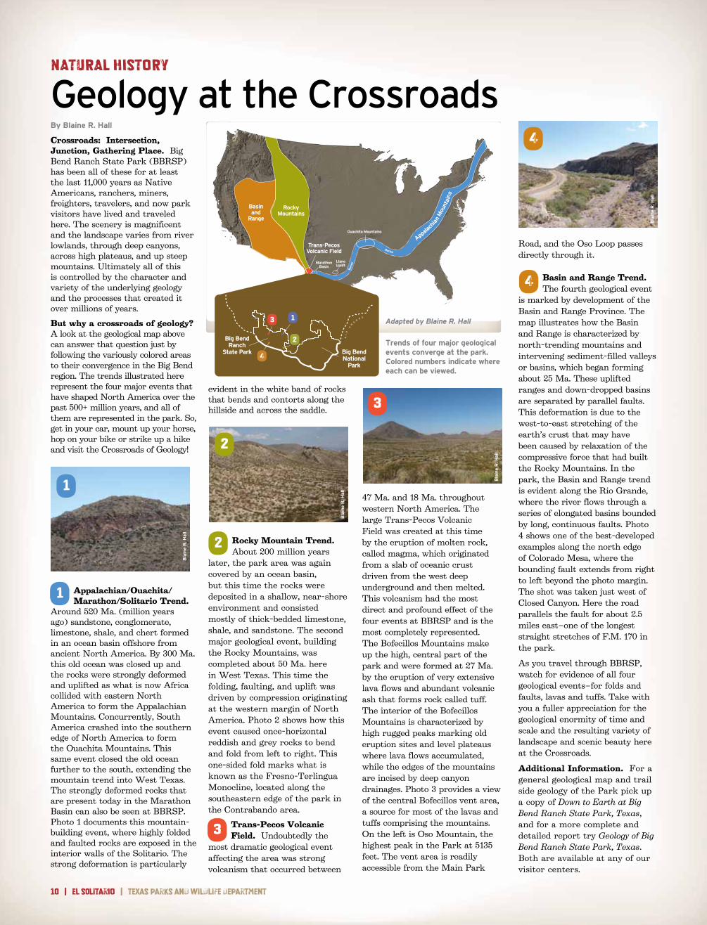
Basin and Range Trend. The fourth geological event
is marked by development of the Basin and Range Province. The map illustrates how the Basin and Range is characterized by north-trending mountains and intervening sediment-filled valleys or basins, which began forming about 25 Ma. These uplifted ranges and down-dropped basins are separated by parallel faults. This deformation is due to the west-to-east stretching of the earth’s crust that may have been caused by relaxation of the compressive force that had built the Rocky Mountains. In the park, the Basin and Range trend is evident along the Rio Grande, where the river flows through a series of elongated basins bounded by long, continuous faults. Photo 4 shows one of the best-developed examples along the north edge of Colorado Mesa, where the bounding fault extends from right to left beyond the photo margin. The shot was taken just west of Closed Canyon. Here the road parallels the fault for about 2.5 miles east–one of the longest straight stretches of F.M. 170 in the park.
As you travel through BBRSP, watch for evidence of all four geological events–for folds and faults, lavas and tuffs. Take with you a fuller appreciation for the geological enormity of time and scale and the resulting variety of landscape and scenic beauty here at the Crossroads.
Additional Information. For a general geological map and trail side geology of the Park pick up a copy of Down to Earth at Big Bend Ranch State Park, Texas, and for a more complete and detailed report try Geology of Big Bend Ranch State Park, Texas. Both are available at any of our visitor centers.
Ouachita Mountains
Buried
Bur
ied
RockyMountains
Basinand
Range
MarathonBasin
Trans-PecosVolcanic Field
LlanoUplift
Appala
chia
n M
ount
ains
Trends of four major geological events converge at the park. Colored numbers indicate where each can be viewed.
3
Bla
ine
R. H
all
4
Bla
ine
R. H
all
Adapted by Blaine R. Hall
2
Bla
ine
R. H
all
RI
O
GR
AN
D E
Big BendRanch
State Park Big BendNational
Park
1
2
3
4
1
3
4
2
Bla
ine
R. H
all
1

big bend ranch state park | el SOLitarIo | 11
By Cynthia Brandimarte
Asking who built and lived in the Madrid House may sound like asking who’s buried in Grant’s Tomb until you become familiar with early land practices in the Big Bend of Texas.
Those who arrived in the Big Bend during the second half of the 19th century and sought to settle in what became southeastern Presidio County searched for arable land along creeks or with flowing springs. They were in no rush, however, to buy and pay taxes on lands where they put down stakes. For one thing, Texas, then only a few decades old, had just begun to develop a process for the sale and leasing of its lands in West Texas, and this induced settlers to keep
mum about their holdings.
The Madrid House rests on the south side of a valley along Madera Creek, a tributary of Fresno Creek. Its legal description, Survey 459, is the site of abundant springs and waterfalls.
Had these attractions been widely known, the site would have been a prized parcel in the area. Presidio County’s first deputy land surveyor, Father Joseph Hoban, did know. Hoban paid $52.50 in May 1880 to secure the patent; he then identified the parcel’s metes and bounds; and a fellow surveyor rubber-stamped its boundaries. The priest drew the tract as a diagonally-shaped square, a variation of the standard grid so often overlain on Big Bend landscape from north to south. Thus, Hoban made a conscious effort to corral the land’s desirable features inside the boundaries he drew. These transactions gave rise to something of a mystery.
In 1967, a historian based in Alpine, Clifford B. Casey, wrote one of the area’s ranchers and miners, Harris Smith, to ask about Hoban. Casey repeated to Smith the by-then widespread belief that Hoban “had a school for boys over in one of the canyons near Buena Suerte properties in Presidio County.” Smith replied that he never knew Hoban but “believe[d] him to be the priest who built the adobe buildings in what we called the Madrid Canyon, over the mesa south of Fresno Canyon ranch house. … He bought up a number of patented watered sections over the country.”
The oft-repeated story about Hoban and the boys’ school always seemed unlikely. But recent research by Robert E. Wright about “transient clergy” in the Big Bend shows priests to have been indefatigable figures during the region’s early settlement. They covered huge areas, served scattered and impoverished populations in places with no churches, heard confessions and said masses in crude dwellings, and they did all this with little sleep and infrequent meals. Hoban was especially energetic and resourceful, having done two periods of hard clerical service in the Trans Pecos (1878-1885 and 1911). By virtue of his ministry and his role as deputy surveyor in Presidio County, he knew much about land. Perhaps, therefore, it was Hoban who did indeed build the core structure of the Madrid House to use as a shelter.
On the other hand, a 1994 interview with Edmundo H. Madrid identified his grandpar-ents and early Polvo settlers, Andres and Eusebia Hinojos Madrid, as the builders and occupants of the House. Having moved north of the Rio Grande as early as the 1870s, the Madrids may indeed have eventually settled on the site, but no deed or tax record places them there.
To compound the Madrid House mystery, their son C.H. “Ceferino” built several of the area’s initial irrigation systems in 1904, but he did not live on the site according to public records. He swore an affidavit to the Texas Land Commissioner that he lived all his life near Polvo and that, as part of the Polvo Irrigation Company, he owned “a ditch that runs across this land and irrigates our land.”
Archeology, History and Culture
The Madrid House: Squatters Ruled
Elvira Madrid married Rueben Madrid, one of Ceferino’s sons, and she may hold the answer. Before Rueben’s death, he would recall family stories of “Rancho de Madrid,” which Andres and Ceferino operated from the mid-1890s to 1916, the year of Andres’s death. Family members lived in the house, and possibly built it, raising sheep and cattle, and farming vegetables and fruits watered by a small-scale irrigation system that family members constructed. At times, the household may have consisted of Ceferino’s parents, wife, and several of his five children.
Some Madrid family members did own and pay taxes on other parcels near Survey 459—just not on it. Even after the state of Texas enacted laws that granted land ownership in exchange for infrastructure improvements or settlement, Survey 459 and adjacent land remained open range where livestock lawfully were permitted to run at large. Without fences, settlers or squatters had only to take control of one or more of the watered sections of land and graze animals there, while keeping any others who wanted “their” land at bay.
Records show that Survey 459 was sold at auction in 1911, because no taxes had been paid on it. Brewster County residents B.C. and Myrtle Cowan Thomas bought the property but never inhabited it. When her husband died, Myrtle Thomas remarried and moved to Bexar County and sold the Survey 459 tract to Alpine merchant George W. Martin for $1,120 in 1916. This generous sum indicated not only the desirability of the watered tract, but also the presence of some improve-ments on it. A 1916 sketch map confirms the improvements.
Was Father Hoban or were members of the Madrid family responsible for the House’s basic structure? Was it constructed initially as a house or a school? Or, did it start as a small shelter? Might the Madrids have started the Hoban legend? Alas, official records leave us without firm answers to these questions. In tandem with architectural and archeological investigations, historical research continues.
By Dennis Gerow
Visitors to Fresno Canyon will discover the remains of Madrid House partially hidden in vegetation above the trail – an empty ruin slowly returning to the earth . Three rooms remain: two of which most likely original, the third an addition that may have began as a corral . Photographs from the early 20th century suggest that Madrid House was once a larger structure, and physical evidence tends to bear this out .
Adobes were made on-site, dried and stacked to form the walls . Wood was scarce but available in limited quantities to make vigas (rafters), doors, windows and lintels . The floor was compacted earth .
Although the roof is gone, a few vigas remain . All exterior plaster has vanished, but one interior wall retains a few traces . Wood-lined door and window openings have long since deteriorated or been scavenged for other structures .
Recent efforts by the Texas Parks and Wildlife Department have focused on the short-term structural stability of the wall foundations . Ongoing plans include monitoring, additional research and interpretation; however the Madrid House will undoubtedly continue its graceful decline .
Today’s Madrid House
Fr. Joseph Hoban(courtesy Catholic Archives of Texas, Austin)
Map of Plot 459

12 | el SOLitarIo | Texas parks and wildlife department
EXECUTIVE DIRECTOR
Carter P . Smith
Peter M. Holt, Chairman
san antonio
T. Dan Friedkin, Vice-Chairman
houston
Mark E. Bivins amarillo
Ralph H. Duggins fort Worth
Antonio Falcon, M.D. rio Grande city
Karen J. Hixon san antonio
Dan Allen Hughes, Jr. Beeville
Margaret Martin Boerne
S. Reed Morian houston
Lee M. Bass, Chairman-Emeritus
fort Worth
TEXAS PARKS AND WILDLIFE DEPARTMENT MISSION STATEMENTTo manage and conserve the natural and cultural resources of Texas and to provide hunting, fishing and outdoor recreation opportunities for the use and enjoyment of present and future generations.
You may view this and other publications through the TPWd Web site. Please visit http://www.tpwd.state.tx.us/publications/.
in accordance with Texas state depository law, this publication is available at the Texas state Publications clearinghouse and/or Texas depository libraries.
TPWD receives federal assistance from the U.S. Fish and Wildlife Service and other federal agencies and is subject to Title VI of the Civil Rights Act of 1964, Section 504 of the Rehabilitation Act of 1973, Title II of the Americans with Disabilities Act of 1990, the Age Discrimination Act of 1975, Title IX of the Education Amendments of 1972, and state anti-discrimi-nation laws which prohibit discrimination the basis of race, color, national origin, age, sex or disability. If you believe that you have been discriminated against in any TPWD program, activity or facility, or need more information, please contact Civil Rights Coordinator for Public Access, U.S. Fish and Wildlife Service, 4401 N. Fairfax Drive, Mail Stop: MBSP-4020, Arlington, VA 22203.
© 2011 Texas Parks and Wildlife department PWd Br P4507-1437 (1/11)
EditorsW. Phil hewittlinda hedges
Regional Directormike hill
General Superintendent
rod Trevizo
el SOLitarIo
By David Long
On October 5, 1899, Robert T. Hill--the father of Texas geol-ogy--set out on the quest of a lifetime. He and his small crew ran, recorded and mapped the Rio Grande from Presidio to Langtry. Although rubber rafts and modern canoes have replaced the wooden john boats of Hill’s day, the Rio Grande retains the same sense of adventure and challenge.
Whether you want to run white-water rapids or leisurely float down the river, the Rio Grande as it passes through Big Bend Ranch State Park has it all. From a half-day to multiple days, you can plan a river expedition to fit your desires and skill level. For those with limited experience and little or no equipment, there are several outfitters in the area who can customize a trip for you. In fact, it is most prudent to take advantage of a guided river trip; doing so can relieve the worries and surprises you may encounter on your own. Local guides are highly trained and knowledgeable to truly
optimize the experience, and will supply the right equipment. If you are planning a multi-day trip, an outfitter will set up camp, provide all camping gear, and cook meals for you. More experienced river runners can bring their own gear or rent from an outfitter.
River access points along F.M. 170 facilitate a variety of trips. The most popular half-day excursion is from Madera Canyon to Grassy Banks, a three-mile run with one rapid. For longer, full-day trips, you may consider Grassy Banks to Lajitas or the more challenging Colorado Canyon. For those wanting a multi-day outing, Arenosa to Lajitas is over 22 miles and can take up to four days. Of course the amount of time and difficulty on any river run depends on water level.
The preferred level is between four and eight feet. Levels over three-and-a-half feet are navigable in rafts (preferred for multi-day trips), whereas canoes and kayaks are better for lower levels. Water depths of over eight feet tend to “wash out” or smooth
many of the rapids due to the swift current; such conditions are recommended only for experienced river runners.
The Rio offers excitement and discovery, but its primary attraction may be the tranquility and sense of coolness it brings to the desert. Bird-watching is prime along the riverbanks. Look for the flighty Black Phoebe or the majestic Great Blue Heron, or listen for the
melodic call of the Canyon Wren. If you are lucky you might even see a Peregrine Falcon or Osprey cruising the river for prey. For those who want to wet a line, channel catfish lurk in deep holes at river bends, some weighing several pounds. There are also fresh water drum, carp, and alligator gar to challenge the skills of the most avid fisherman.
Safety on the Rio is not much different than it was a hundred years ago when Robert T. Hill made his historic run. The most dangerous aspects are the natural conditions. Be prepared. Discuss your plans with a ranger at Barton Warnock Visitor Center, Fort Leaton State Historic Site or Sauceda Ranger Station, where you can check current weather and river conditions, leave an itinerary, and obtain information about local guide services to make the most of your adventure.
Scenic Colorado Canyon proves a popular destination for river enthusiasts.
Big Bend Ranch State Park Sauceda Ranger StationP.O. Box 2319Presidio, Texas 79845fax (432) 358-4679Phone (432) 358-4444
General Superintendent Officehcr 70, Box 375Terlingua, Texas 79852fax (432) 424-3404Phone (432) 424-3341
Barton Warnock Visitor Centerhcr 70, Box 375Terlingua, Texas 79852fax (432) 424-3404Phone (432) 424-3327
Fort Leaton State Historic SiteP.O. Box 2439Presidio, Texas 79845fax (432) 229-4814Phone (432) 229-3613
Texas Parks and WildlifeDepartment Headquarters4200 smith school roadaustin, Texas 78744(512) 389-4800(800) 792-1112www.tpwd.state.tx.us
An adventurous couple shoots the rapids
El Solitario: What’s in a name?Spanish for “hermit” or “loner,” El Solitario is the signature landscape feature of the park. Almost 10 miles across, this collapsed and eroded volcanic dome may be viewed from Solitario Overlook, a few miles past Sauceda Ranger Station. For a closer look you’ll need a high clearance vehicle. Ask a ranger for directions and current road conditions.
Raft the Rio Grande
XX%
Cert no. XXX-XXX-000
www.tpwd.state.tx.us/bigbendranch
Cry
stal
Allb
righ
t
Cry
stal
Allb
righ
t