Wilderness register and indicator for...
92
Wilderness register and indicator for Europe Final report October 2013 Contract N o : 07.0307/2011/610387/SER/B.3 A.T. Kuiters, M. van Eupen, S. Carver, M. Fisher, Z. Kun & V. Vancura Borjomi-Kharagauli NP © Konstantin Gabrichidze
Transcript of Wilderness register and indicator for...

Wilderness register and indicator for Europe
Final report
October 2013
Contract No: 07.0307/2011/610387/SER/B.3
A.T. Kuiters, M. van Eupen, S. Carver, M. Fisher, Z. Kun & V. Vancura
Borjomi-Kharagauli NP © Konstantin Gabrichidze


Contents
Executive summary 5
1 Background 7
1.1 Objectives 8
1.2 Setting a working definition for wilderness 8
2 European database on protected areas 11
2.1 CDDA database 11
2.2 IUCN Management categories 13
2.3 Natura 2000 database 15
3 Biodiversity indicators 17
4 Wilderness register 19
4.1 Objective 19
4.2 Data sources 19
4.3 Stakeholder consultations 29
4.4 Verification by National Focal Points 33
4.5 Draft wilderness register 34
4.6 Overlap with Natura 2000 39
4.7 Discussion 39
5 Proposal for a wilderness indicator 40
5.1 Objective 40
5.2 Exploration of relevant datasets 41
5.3 EU-wide datasets 42
5.4 Regional datasets for the analysis of wilderness 45
5.5 Mapping approach, combining indicators 47
5.6 Methods deriving maps for each factor 49
5.7 Usage for monitoring purposes 61
5.8 Mapping European wilderness 61
5.9 Draft wilderness indicator: data improvement 71
6 Achieved results 72
7 Recommendations for future actions 75
7.1 Wilderness register: proposal on data management and updating 75
7.2 Wilderness indicator: proposal on data improvement 75
7.3 Public access 76
Glossary 79
References 81
ANNEXES 83
Annex 1: IUCN management categories relevant for wilderness protection 83
Annex 2: Stakeholders involved in the consultation process 89
Annex 3: NFPs and the verification process 91

Annex 4: Detailed information on PAs in the wilderness register 92

WILDERNESS REGISTER and INDICATOR for EUROPE
5
Executive summary
The main aim of the contract was to increase data availability on wilderness in Europe. The Guidelines
on management of wilderness and wild areas in Natura 2000 (DG Environment, in prep.) described
the benefits of wilderness management within the framework of the EU Biodiversity strategy, analysed
the pressures affecting wilderness areas and provided guidelines on their management and protection,
largely based on best practice examples of wilderness and wild areas throughout Europe. However, an
overview of remaining areas of wilderness and wildlands at the European continental scale was still
missing.
The aim of increasing data availability was translated into two main goals:
a) Compilation of a Wilderness register using existing databases, such as the EEA and WDPA,
identifying in tandem with appropriate interested parties the remaining areas of wilderness and
wild areas.
b) Completion of mapping wilderness and wild areas in Europe, involving appropriate definitional and
habitat criteria and level of scale to effectively support plans for protecting and monitoring such
areas.
In Chapter 1 we provide a working definition of wilderness, compatible with the IUCN guidelines on
protected areas management category Ib (‘wilderness’) with additions and slight modifications to
make it applicable for the filtering of protected areas for the wilderness register from the most relevant
databases on protected areas, and for the selection of suitable databases for the wilderness indicator..
Wilderness is defined as an area governed by natural processes. It is composed of native habitats and
species, and large enough for the effective ecological functioning of natural processes. It is unmodified
or only slightly modified and without intrusive or extractive human activity, settlements,
infrastructure or visual disturbance. We make a distinction between wilderness and wild areas. Wild
areas tend to be more fragmented than wilderness areas. The condition of their natural habitat,
processes and relevant species is often partially or substantially modified by human activities such as
livestock herding, fishing, forestry, sport activities or general imprint of human artefacts. However,
through certain management measures they have the potential to be transformed into wilderness.
The most relevant datasets are the European CDDA database, managed by the EEA and being part of
the worldwide WDPA database on protected areas, and the Natura 2000 database. In Chapter 2 we
describe these databases and their relevance for this project.
The mapping of wilderness and wild areas in Europe will result in a wilderness indicator. This
indicator permits the spatial analysis ofthe occurrence of wilderness qualities at the European
continental scale and the description of future trends. As such it will become part of the set of
Biodiversity indicators managed by the EEA for policy support in actions for halting biodiversity loss.
These are described in Chapter 3.
In Chapter 4 we describe the methodology used to compile a register for wilderness. It covers 39
countries being member or collaborate member of EEA. For practical reasons, the CDDA database on
national designated areas was used as the main dataset, because it is one of the few datasets on
protected areas which contains information on management objectives. We describe the filtering steps
leading to a list of pre-selected protected areas most likely to host wilderness qualities. Consultation by
stakeholders (NGOs) and site managers was carried out to check quality of the available data related to

WILDERNESS REGISTER and INDICATOR for EUROPE
6
the criteria for wilderness derived from the wilderness definition. This is listed in a set of 522 protected
areas, that either qualified as wilderness category A or A/B (meeting most of the criteria; 284 PAs )
and category B (wild areas; 238 PAs), i.e. typical wild areas, partly meeting the criteria for wilderness,
and with the potential to become wilderness category A if specific management measures are taken. In
the EU27, most category A wilderness areas are protected and designated as Natura 2000 area, with a
total coverage of 4-5% of the total Natura 2000 network. By far the largest part of these areas is
located in the Nordic countries with smaller areas in the Baltic region and in mountainous regions in
Europe i.e. Alps, Carpathians, Pyrenees, Apennines.
The presented draft register is not complete yet and should be complemented with further data, in
particular for those countries which have not verified/provided available data (15 countries).
A proposal for a wilderness indicator for monitoring wilderness qualities in Europe is presented in
Chapter 5. This draft indicator is based on multi-criteria evaluation and fuzzy methods, and built on a
number of consistently mapped European-wide spatial datasets related to remoteness from access,
remoteness from settlements, naturalness of land cover and terrain ruggedness, the key qualities
related to wilderness. For mapping, these four sub-indicators are combined into a single wildness
indicator, applicable at the European scale. It has a 1 x 1 km resolution, showing wilderness quality on
a linear scale between 0-100. A wilderness map for Europe is presented based on the proposed
method. The map shows that the likeliness of wilderness qualities is highest in the Fenno-
Scandinavian region, the Baltic region, mountainous regions such as the Carpathians, Alps, Apennines,
Pyrenees and the Balkan region, in accordance with the picture emerging from the register.
By overlaying the wilderness indicator with the Natura 2000 spatial database we were able to detect
protected areas with potentially high wilderness qualities, but not registered in the CDDA database.
The potential wilderness qualities of these areas have to be checked by National Focal Points and if in
accordance with the set of criteria subsequently added to the register. The draft wilderness indicator
will also allow the quantitative assessment of trends in the extent of remote land throughout Europe
using GIS techniques. We were also able to detect areas, especially in the Nordic regions where
unprotected areas occur (neither registered in CDDA, Natura 2000 or the WDPA database) with
potentially high wilderness qualities.
The wilderness register and the draft indicator are the outcome of scientifically based, but different
methodologies. Both indicate that wilderness still occurs in Europe, but mostly in a fragmented form.
Extensive unfragmented areas are mainly restricted to the Nordic countries. The register can and
should be improved and completed by making more data available. In Chapter 6 we make
recommendations for a further increase in data availability on wilderness in Europe and for updating
the wilderness register and indicator in due course.

WILDERNESS REGISTER and INDICATOR for EUROPE
7
1 Background
At the EU Presidency Conference on ‘Wilderness and Large Natural Habitat Areas in Europe’, 27-28th
May 2009 in Prague, the need for a compilation of a Register of Wilderness for Europe was raised. The
register should give an overview of remaining areas of wilderness and wild lands at the European
continental scale. In the ‘Message from Prague’ it says under the paragraph ‘further work and
information needs’ (C2 and C3):
Compilation of a Register of Wilderness using existing databases, such as the EEA (European
Environmental Agency, Copenhagen) and WDPA (World Database on Protected Areas),
identifying in tandem with appropriate interested parties the remaining areas of wilderness
and wildlands, the threats and opportunities related to these, and their economic values, with
practical recommendations for action.
Completion of mapping wilderness and wildland areas in Europe, involving appropriate
definitional and habitat criteria and level of scale to effectively support plans for protecting
and monitoring such areas.
Additionally the Prague message says that ‘Information provided by a Wilderness Register will be a
key factor in conservation projects, therefore validity and accuracy of the data should be as precise
as possible. A European Wilderness Register would also help with policy development and protect
against the further loss of biodiversity’.
The EU is internationally committed to the protection of biodiversity, and to halting biodiversity and
reversing loss within the EU by 20201. In May 2011, the European Commission launched a new
strategy to halt and reverse biodiversity loss by 20202. The strategy includes six main targets, and
twenty actions, which address the main drivers of biodiversity loss, and which will reduce the main
pressures on nature and ecosystem services in the EU by anchoring biodiversity objectives in key
sectorial policies. The protection and, where necessary, restoration of Europe's last wilderness areas
can significantly contribute to halting the loss of biodiversity. The benefits of these wilderness areas
are significant, especially in terms of retaining biodiversity and for addressing the adverse effects of
climate change3.
For the purposes of policy development and decision making, areas with wilderness qualities need to
be identified.
In the technical tender document it says: ‘In order to produce a widely accepted spatial analysis
product and to make the product coherent with existing EU biodiversity indicators, the analysis
needs to be based on datasets available from the Biodiversity Data Centre (BDC) and the Biodiversity
Information System for Europe (BISE). The work needs to build on the European Environment
Agency’s (EEA) Net Landscape Potential Index (NLEP)’.
1 http://www.cbd.int/convention/articles/?a=cbd-02
2 http://ec.europa.eu/environment/nature/biodiversity/policy/index_en.htm
3 Locke, H. & B. Mackey (2009). The Nature of Climate Change, Reunite International Climate Change Mitigation Efforts with
Biodiversity Conservation and Wilderness Protection. International Journal of Wilderness 15: 7-13.

WILDERNESS REGISTER and INDICATOR for EUROPE
8
Furthermore it says: ‘A specific European indicator on wilderness is still missing. Spatial analysis
related to this indicator needs to be developed in a close co-operation with the relevant stakeholders,
most importantly the EEA, in order to meet the objectives set for European biodiversity indicators’.
1.1 Objectives
The overall objective of this project was to improve the data availability on wilderness, allow the
monitoring of wilderness qualities and enable enhanced protection of biodiversity and landscape
values. This was achieved by:
a) producing a spatial analysis tool that can be adopted as a draft for a European biodiversity indicator
on wilderness in Europe
b) by creating a draft register of protected wilderness areas.
The register and indicator will together support countries in- and outside the EU to set their own
priorities for maintenance and improvement of protected sites with wilderness qualities at their
territory. It may also offer opportunities for stronger public participation in wilderness protection.
1.2 Setting a working definition for wilderness
Wilderness areas represent a vital element of Europe’s natural and cultural heritage. For a working
definition of wilderness, we follow the EU Guidance on the management of wilderness and wild areas
in Natura 2000 (European Commission, 2012; in press4):
A wilderness is an area governed by natural processes. It is composed of native habitats and species,
and large enough for the effective ecological functioning of natural processes. It is unmodified or
only slightly modified and without intrusive or extractive human activity, settlements, infrastructure
or visual disturbance.
This definition was developed by the Wilderness Working Group, as part of the Wild Europe Initiative
and agreed by the European Commission5.
This definition is compatible with the IUCN guidelines on protected area management class Ib
‘Wilderness’6. Category Ib protected areas are usually large unmodified or slightly modified areas,
retaining their natural character and influence, without permanent or significant human habitation,
which are protected and managed so as to preserve their natural condition (Dudley 2008).
Our working definition is more explicit on important characteristics related to biological and
anthropogenic qualities of wilderness, i.e. native habitats and species, no extractive or intrusive human
activity, no infrastructure and no visual disturbance. This allows us to pose a clear set of criteria to
filter protected areas from the CDDA database that might qualify as wilderness for the wilderness
4 http://ec.europa.eu/environment/nature/natura2000/wilderness/pdf/guidance.pdf 5 Wild Europe (2012). A Working Definition of European Wilderness and Wild areas. Discussion Draft; 25 October 2012; 17 p.
6 Dudley, N. (Ed.) (2008). Guidelines for Applying Protected Area Management Categories. Gland, Switzerland: IUCN. x +
86pp

WILDERNESS REGISTER and INDICATOR for EUROPE
9
register (Chapter 4) and to select suitable databases for a wilderness indicator, which allows the
calculation of wilderness index values for certain areas or regions (Chapter 5).
Generally, three ‘zones’ can be distinguished in wilderness areas: i.e.
a) a core zone with a predominance of natural processes and a minimal human interference,
surrounded by
b) a buffer zone with a relatively low impact of human activities, which in turn is surrounded by
c) a transition zone where a range of human activities is permitted but under certain restrictions.
In the buffer zone, emphasis is mostly on restoration/rewilding7 of natural habitats and processes.
And where feasible, parts of this zone might in the short or longer term be incorporated into the core
zone and expand outwards over time into the transition zone.
This structure offers best protection of key wilderness principles, allowing potential for future
expansion and interaction with other forms of land use8.
We make a distinction between wilderness and wild areas (or wild lands):
Wild areas have a high level of predominance of natural processes and natural habitat. They tend to
be more fragmented than wilderness areas, although they often cover extensive tracts. The condition
of their natural habitat, processes and relevant species is however often partially or substantially
modified by human activities such as livestock herding, fishing, forestry, sport activities or general
imprint of human artefacts9.
Through certain management measures wild areas can often be developed to wilderness, for instance
by removing all forms of human interference and/or by interconnecting fragmented wild zones in an
area by removal or bridging of ecological barriers. A minimum of 10,000 hectares for the core zone
seems ecologically reasonable, allowing the effective ecological functioning of natural processes. The
minimum size, however, will be dependent on ecosystem types involved and local geography.
7 Restoration involves reinstatement of natural habitats and processes, eventually together with reintroduction of wildlife, i.e.
indigenous species appropriate to the area at present time. Rewilding is the return of an area to a wild natural condition by
initiating, stimulating and allowing natural processes to become predominant again. 8 Wild Europe (2012). A Working Definition of European Wilderness and Wild areas. Final version; 25 October 2012; 17 p. 9 Wild Europe (2012). A Working Definition of European Wilderness and Wild Areas. Final version; 25 October, 2012; 17 p.

WILDERNESS REGISTER and INDICATOR for EUROPE
10

WILDERNESS REGISTER and INDICATOR for EUROPE
11
2 European database on protected areas
Protected areas today cover a relatively large part of Europe, with almost 21 % of the territory of EEA
member countries and cooperating countries consisting of protected areas10. A 'protected area' is any
site with defined boundaries classified or designated by countries under legislation primarily aiming at
nature conservation i.e. at the protection, management and restoration of species, habitats and
ecosystems. The most important international legal agreements for protected areas in Europe are the
UN Convention on Biological Diversity and the EU Birds and Habitats Directives. Protected areas
(PAs) in Europe are registered in the European CDDA (Common Database on Designated Areas)
database.
2.1 CDDA database
The European inventory of nationally designated areas holds information about protected sites and
about the national legislative instruments, which directly or indirectly create protected areas11. The
CDDA database managed by EEA contains data on individual nationally designated sites and
designations in EEA member and collaborating countries12.
The inventory began under the CORINE program and is now maintained for EEA by the European
Topic Centre on Biological Diversity (ETC/BD) and is annually updated through EIONET. This is a
partnership network of the EEA and its member and cooperating countries involving approximately
1000 experts and more than 350 national institutions. The network supports the collection and
organisation of data and the development and dissemination of information concerning Europe’s
environment. EEA provides the European inventory of nationally designated areas to the WDPA and
to Eurostat. The nationally designated areas data can also be queried online in the European Nature
Information System (EUNIS). The inventory is the national module of the CDDA database, which also
includes information on areas designated under European Community legislation and areas
designated under international conventions.
The designation types of protected areas are classified according to three categories:
Category A: Designation types used with the intention to protect fauna, flora, habitats and landscapes
(the latter as far as relevant for fauna, flora and for habitat protection).
Category B: Statutes under sectorial, particularly forestry, legislative and administrative acts
providing an adequate protection relevant for fauna, flora and habitat conservation.
Category C: Private statute providing durable protection for fauna, flora or habitats
The CDDA database is including category A mainly.
For non-EU countries, the list is based on the data being prepared under the Emerald network of the
Bern Convention. As Emerald is being developed on the same scientific and technical basis, the same
coding principles are applied.
10 EEA (2012). Protected areas in Europe –an overview. EEA Report No 05/2012. Copenhagen. 130 p. 11 A nationally designated area is an area designated by a national designation instrument based on national legislation. 12 http://dd.eionet.europa.eu/datasets/latest/CDDA/tables/designations

WILDERNESS REGISTER and INDICATOR for EUROPE
12
The 2011 CDDA data set covers 52 countries with over 120,000 records in the database and over
112,000 spatial records (Table 2.1). EEA is responsible for data collection from EEA member and
collaborating countries (39), while UNEP-WCMC (United Nations Environment Programme-World
Conservation Monitoring Centre) is responsible for collection of data from several other European
countries (13) (Table 2.1).
In 39 countries in the European territory, on average 16 % of the terrestrial area has been designated
as a national protected area13.
The CDDA database contains both spatial data (i.e. boundaries) and attribute data (i.e. information)
about protected areas. The spatial data are represented by shapefiles in polygon format (ArcGIS) and a
geographic location (latitude and longitude) as point data.
2.1.1 Restrictions on data dissemination
EEA does not have permission to distribute some or all sites reported by Austria, Bulgaria, Estonia,
Ireland, Malta, the Netherlands, Romania, Spain and Turkey. Copyright has to be mentioned for
Estonia, Finland, Germany and Slovenia.
2.1.2 Relation with the WDPA database
The CDDA database is part of the worldwide WDPA database, based on a memorandum of
understanding between EEA and UNEP/WCMC (2007). There is on- going joint work of the two
organisations on the European content of the global database.
The WDPA is a global spatial dataset on marine and terrestrial protected areas14. It is managed at
UNEP-WCMC in Cambridge, UK, supported by IUCN staff and World Commission on Protected Areas
(WCPA) members all over the world. Since 1981, UNEP-WCMC through its Protected Areas Program
has been compiling this information and making it available to the global community15. It relies on
work carried out by staff in institutions covering every country in the world.
In 2010, the website Protected Planet was launched (www.protectedplanet.net) by a joined action of
UNEP and IUCN. This is an interactive, social media-based website that provides information on
150,000 protected areas worldwide. Protected Planet is an initiative that makes digital information
about national parks and protected areas available for global internet users, with the 'citizen science’
approach enabling anyone to edit and contribute to protected areas information. A WDPA team has
prepared data standards with instructions on data requirements and the conditions of submitting data
to the WDPA16. The WDPA contains both spatial (i.e. boundaries) and attribute (i.e. information) data
of protected areas.
13 EEA (2012). Protected areas in Europe –an overview. EEA Report No 05/2012. Copenhagen. 130 p. 14 http://www.wdpa.org/ 15 http://www.unep-wcmc.org/ 16 http://www.wdpa.org/PDF/WDPA%20Data%20Standard.pdf

WILDERNESS REGISTER and INDICATOR for EUROPE
13
2.2 IUCN Management categories
The term ‘protected area’ embraces a wide range of different management approaches, from highly
protected sites where few if any people are allowed to enter, through parks where the emphasis is on
conservation but visitors are welcome, to much less restrictive approaches where conservation is
integrated into the traditional (and sometimes not so traditional) human lifestyles or even takes place
alongside limited sustainable resource extraction. Some protected areas ban activities like food
collecting, hunting or extraction of natural resources while for others it is an accepted and even a
necessary part of management (Dudley, 200817).
The IUCN set out the following definition of a “protected area” (Dudley, 2008):
‘A protected area is a clearly defined geographical space, recognised, dedicated and managed,
through legal or other effective means, to achieve the long-term conservation of nature with
associated ecosystem services and cultural values.’
According to the CBD ‘Protected area’ means a geographically defined area which is designated or
regulated and managed to achieve specific conservation objectives18.
The IUCN-WCPA19 has distinguished the following six categories of protected areas. These are areas
managed mainly for:
I: Strict protection (Ia Strict nature reserve; Ib Wilderness area)
II: Ecosystem conservation and protection (i.e. National park)
III: Conservation of natural features (i.e. Natural monument)
IV: Conservation through active management (i.e. Habitat/species management area)
V: Landscape/seascape conservation and recreation (i.e. Protected landscape/seascape)
VI: Sustainable use of natural resources (i.e. Managed resource protected area)
The IUCN protected area management categories are a global framework, recognised by the
Convention on Biological Diversity, for categorizing the variety of protected area management types.
They classify protected areas according to their management objectives. The categories are recognised
by international bodies and by many national governments as the global standard for defining and
recording protected areas and as such are increasingly being incorporated into government legislation.
The way individual countries apply these categories to their own context, however, is quite variable
and is the cause of much debate20. For instance, national parks are differently defined by the national
legislation in various countries, and protected areas called 'national parks' can be found in several of
the IUCN protected area categories. Sometimes national legislation makes reference to the IUCN
management categories but interprets these in different ways. There is sometimes confusion about the
relationship between the definition of conservation objectives for a protected area and its
classification.
17 Dudley, N. (Ed.) (2008). Guidelines for Applying Protected Area Management Categories. Gland, Switzerland: IUCN. x + 86
pp.
18 CBD Programme of Work on Protected Areas; http://www.cbd.int/protected/pacbd/
19 WCPA: World Commission on Designated Areas (commission of the IUCN); is one of the six voluntary Commissions of IUCN
and is administered by the Programme on Protected Areas at IUCN’s headquarters in Gland, Switzerland. 20 EEA (2012). Protected areas in Europe — an overview. EEA Report No 05/2012. Copenhagen. 130 p.

WILDERNESS REGISTER and INDICATOR for EUROPE
14
Additionally, difficulties are often encountered in interpreting the categories system for large protected
areas. These may have elements and respective management objectives that correspond to two or more
management categories. The guidelines recommend that each individual protected area be assigned to
a particular category, based on its primary objective. In order to establish the appropriate category, at
least 75% and preferably more of the area must not be in conflict with that primary purpose.
Sometimes one category ‘nests’ within another. For instance, national parks (category II) often contain
category Ia and Ib areas. This is entirely consistent with the application of the IUCN categories systems
for management objectives, providing such areas are identified separately for accounting and reporting
purposes21.
Furthermore, there are sometimes complications with the use of category II (National park).
Sometimes there is a strong political pressure to ensure that such areas are so classified in the national
list, whilst the management objectives do not fulfill the requirements of category II22.
The CDDA database includes information on which IUCN management category applies to nationally
designated sites in Europe. So far, this information has been provided for almost 70 % of the sites
across the 39 EEA countries. However, in the case of the Flemish part of Belgium, parts of Greece,
Slovakia, Slovenia, Spain and Turkey, the data are either lacking or incomplete. These data are also
lacking or not used at all for very small sites in Scandinavia. In Estonia, IUCN management categories
are allocated to each different management area within a designated site23.
Most relevant for wilderness are the categories Ia, Ib, II and VI. These are summarized in Annex 1,
based on texts of the IUCN-guidelines.
Category Ia, ‘strict nature reserves’, are strictly protected areas set aside to protect biodiversity and
geodiversity features, and are free of significant human intervention which usually implies limiting
access and excluding settlement and any forms of land use. They are strictly controlled and limited to
ensure the protection of nature conservation values. They mostly have a full set of native habitats and
species with intact ecological processes. They can represent wilderness qualities, especially when these
areas are large enough to ensure integrity of ecosystems.
Category Ib, ‘wilderness area’, are natural areas with a high degree of intactness, undisturbed by
significant human interference, free of modern infrastructure (roads, pipelines, power lines, cellphone
towers, oil and gas platforms etc.), where natural processes prevail. They are protected to preserve
their natural condition. Category Ib areas are mostly areas with high wilderness qualities. In Nordic
countries indigenous communities can maintain here their traditional wilderness-based lifestyle.
Category II, ‘National park’, are protected natural or near natural areas set aside to protect large-scale
ecological processes, and to promote education and recreation. Visitor use is managed for educational,
cultural and recreational purposes in a way that will not cause significant ecological degradation. Many
21 http://data.iucn.org/dbtw-wpd/edocs/1999-048-2.pdf 22 http://data.iucn.org/dbtw-wpd/edocs/1999-048-2.pdf 23 EEA (2012). Protected areas in Europe –an overview. EEA Report No 05/2012. Copenhagen. 130 p.

WILDERNESS REGISTER and INDICATOR for EUROPE
15
national parks have zoning, with core zone(s) characterised by non-intervention management. These
represent wilderness qualities.
Category VI, ‘protected area with sustainable use of natural resources’, are protected areas to
conserve ecosystems and habitats together with associated cultural values and traditional natural
resource management systems to preserve biodiversity in such a way to provide products and
ecosystem services for the community. They are generally large with most of the area in a natural
condition. Most category VI areas do not represent wilderness qualities. Finland, however, has
assigned this category to many of their wilderness areas, because of subsistence use of resources for
reindeer herding by the Sámi people24.
2.3 Natura 2000 database
Natura 2000 is the ecological network of protected areas in the EU27, set up to ensure the survival of
Europe's most valuable species and habitats. It is comprised of Special Areas of Conservation (SAC)
designated by Member States under the Habitats Directive, and also incorporates Special Protection
Areas (SPAs) which they have designated under the 1979 Birds Directive.
Every site in the database has a unique code which comprises nine characters and consists of two
components. The first two characters represent the country code; the remaining seven characters
create a unique alphanumeric code for each site.
Besides general information on attributes such as size, location, latitude and longitude, Nuts code,
biogeographical region, date of designation, protection status, ownership, and responsible
management body, the database holds for each site information on species and habitats for which the
site is designated. The elaboration of GIS features for Natura 2000 is an ongoing project, which has
not yet been completed. The Natura 2000 GIS is up and running since 2010
(http://www.eea.europa.eu/themes/biodiversity/document-library/natura-2000/natura-2000-
network-statistics/area-calculations-2007-to-2009/gis-area-of-natura-2000-network). Both the
European descriptive database and the GIS features are managed by DG Environment with support of
EEA and ETC/BD. The database is updated twice a year.
2.3.1 Overlap with CDDA database
For almost all 27 EU Member States, protected areas listed in the CDDA partly overlap with Natura
2000 sites designated under the habitats and birds EU directives. The degree of overlap between
CDDA and Natura 2000 sites is known and has been published in the 2012 EEA protected area
report25. This overlap varies from almost 100% for certain MS (e.g. Latvia, Estonia) to less than 5% for
others (e.g. Cyprus, Ireland, and Luxembourg). Different countries follow different approaches26.
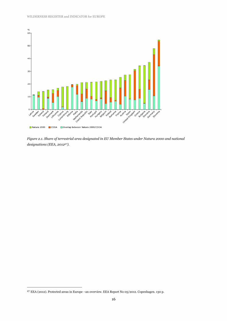
Some countries have the same site designated as a national site and as a Natura 2000 site, other
countries have part of the Natura 2000 site designated as a national site or vice versa (Fig. 2.1)
24 http://data.iucn.org/dbtw-wpd/edocs/1999-048-2.pdf 25 EEA (2012). Protected areas in Europe –an overview. EEA Report No 05/2012. Copenhagen. 130 p. 26 EEA (2012). Protected areas in Europe –an overview. EEA Report No 05/2012. Copenhagen. 130 p.
WILDERNESS REGISTER and INDICATOR for EUROPE
16
Figure 2.1. Share of terrestrial area designated in EU Member States under Natura 2000 and national
designations (EEA, 201227).
27 EEA (2012). Protected areas in Europe –an overview. EEA Report No 05/2012. Copenhagen. 130 p.

WILDERNESS REGISTER and INDICATOR for EUROPE
17
3 Biodiversity indicators
The pan-European initiative, SEBI 2010 (Streamlining European 2010 Biodiversity Indicators), was
launched in January 2005 to develop a European set of biodiversity indicators for assessing and
informing about progress in halting biodiversity loss. The EEA has worked on developing this set since
2005, in collaboration with countries, international organisations, non-governmental organisations,
the European Commission and the UNEP. What is now ready is a detailed description of each of the
indicators (26), complete with methodological data, i.e. how to calculate and use them28.
One challenge when developing the set of indicators has been to find indicators with good geographical
coverage, i.e. indicators which can be calculated for countries at a pan-European scale. Other
challenges have been to boil the set down to a manageable number of indicators, and to choose the
ones that are most helpful to reach policy objectives.
The wilderness indicator, when available, will be added to the set of biodiversity indicators managed
by EEA.
28 http://www.eea.europa.eu/publications/streamlining-european-biodiversity-indicators-2020

WILDERNESS REGISTER and INDICATOR for EUROPE
18
WILDERNESS REGISTER and INDICATOR for EUROPE
19
4 Wilderness register
4.1 Objective
The aim of compiling a wilderness register is to improve data availability at the level of countries all
over Europe, and make it possible for countries to set their own priorities for maintenance and
improvement of wilderness quality at their national territory, with specific attention for trans-
boundary areas since, like biodiversity, wilderness is no respecter of political boundaries. In the long
run the wilderness register should give support on protection prioritising.
The wilderness register exist of a tabular database in MS Access with attribute data; a spatial database
(GIS-based) with information on boundaries represented by shapefiles in polygon format and point
data (latitude, longitude in appropriate projection) has to be added in the future. This information has
to be made available by consultation of local authorities.
The register has the form of a stand-alone database, but can be linked to the CDDA database via the
unique identifier.
The identification of potential threats of wilderness areas was not part of this contract, but might be a
next step in the protection of wilderness areas in Europe (see recommendations, Chapter 6).
4.2 Data sources
The register is primarily based on the CDDA database of protected areas. The register covers the main
part of the European territory (39 countries), i.e. EU27 + 6 candidate Member States (Croatia,
Macedonia, Iceland, Montenegro, Serbia, Turkey) + 6 other countries being EEA members (Albania,
Bosnia-Herzegovina, Kosovo, Liechtenstein, Norway, Switzerland). Therefore, parts of the Emerald
network (outside Natura 2000) are included as well (Table 4.1)29. Not included are Russia and other
parts of the former Soviet Union.
The selection of the 39 countries had mainly a practical reason: they are all member of EEA or
collaborate with EEA, and provide data for the CDDA database, managed by EEA and ETC/BD. This
database was the basic data source, as it contains information on nationally designated protected areas
and their main conservation objectives.
29 The Emerald network is an ecological network to conserve wild flora and fauna and their natural habitats of Europe, which
was launched in 1996 by the Council of Europe as part of its work under the convention on the Conservation of European
Wildlife and Natural Habitats (Bern Convention) that came into force on June 1, 1982. The Emerald network is a network of
areas of special conservation interest (ASCIs), which is to be established in the territory of the contracting parties and
observer States to the Bern Convention, including, among others, central and east European countries and the EU Member
States. It comprises 45 countries, many of which are outside the EU. Natura 2000 is considered to be the EU contribution to
the Emerald Network. For non-EU members, The Emerald network is still in its initial phase and has nominated 1,280 sites
covering almost 95,000 km2.

WILDERNESS REGISTER and INDICATOR for EUROPE
20
The Natura 2000 database was not used as a primary data source. This database contains no
information on management objectives and ‘wilderness protection’ is not distinguished as a special
provision within the Natura 2000 framework. Therefore, from the database we do not have any
information on these areas which might qualify them as wilderness. Moreover, for many countries
there is a rather big overlap between CDDA and Natura 2000 databases (see paragraph 2.3), and
therefore the chance that wilderness areas would be ‘missed’ because we relied mainly on the CDDA
database was rather small.
During the verification process, data managers of National Focal Points (EIONET) have been asked to
add Natura 2000 sites to the list in case they entail wilderness qualities (see paragraph 4.5). This acts
to further minimise the chance of overlooking sites with wilderness qualities. In incidental cases this
has been done by NFPs (see Annex 4).
Another approach we followed was by overlaying the European wilderness map (based on a wilderness
indicator developed in this contract; see Chapter 5) with the Natura 2000 map, to identify those
Natura 2000 sites with high wilderness qualities, but were not included in the CDDA database. This
exercise resulted in the identification of a restricted number of sites which potentially might have
wilderness qualities. For the results of this approach see paragraph 5.8.1
4.2.1 IUCN Management categories
Based on the CDDA database (vs.9/full version), a preliminary list was compiled of protected areas
where wilderness qualities might occur. Protected areas of the following IUCN management categories
were selected:
Ia/Ib: Strict nature reserve / Wilderness area
II: National park; some protected areas contain zones classified and mapped by law as having
different management objectives than the protected area itself. For example, national parks
can contain wilderness areas which have a stricter management regime than the national park
they reside in.
VI: Protected area with sustainable use of natural resources; Finland (and possibly Estonia)
uses this category for part of their protected areas/zones within designated areas with
wilderness qualities (see Fig. 4.1). Finland is under way with assignment and reassignment of
categories for all state-owned protected areas. It is very likely that all present category VI sites
will be reassigned to category Ib.
For the relevance of these management categories for wilderness, see paragraph 2.2.
4.2.2 Size criterion
Protected areas in the CDDA database of category Ia/Ib encompass areas from less than one hectare to
>500,000 ha. To be able to make a pre-selection of potential wilderness areas, we used a minimum
size criterion.
From an ecological point of view it can be argued that a wilderness area should met minimum size
features, i.e. is large enough for the effective ecological functioning of natural processes (see working

WILDERNESS REGISTER and INDICATOR for EUROPE
21
definition in paragraph 1.2). The spatial scale needed for maintaining the ecological integrity of a
natural area determines its minimum size (i.e. scale needed for undisturbed natural ecological
processes and viable species populations). Of course, this will be largely dependent on the ecosystem
types involved.
Figure 4.1. Distribution of nationally protected areas (CDDA) in Europe according to their IUCN category
classification (EEA, 201230).
The IUCN guidelines do not use any minimal size limit for a wilderness area (Category Ib). Sweden, by
the Swedish Environmental Protection Agency (SEPA), has decided on additional standards for IUCN
category Ib; one of them is:
areas should be larger than 1,000 ha in northern Sweden and larger than 500 ha in southern
Sweden31.
The US Wilderness Act (1964) mentions a minimum size of 5,000 acres32. The US Forest Service uses
the following criterion33:
1. They contain 5,000 acres or more (~2,000 ha).
2. They contain less than 5,000 acres but:
due to physical terrain, natural conditions can be preserved;
30 EEA (2012). Protected areas in Europe –an overview. EEA Report No 05/2012. Copenhagen. 130 p. 31 http://www.europarc.org/uploaded/documents/313.pdf 32 US Wilderness Act (1964) http://www.wilderness.net/index.cfm?fuse=NWPS&sec=legisAct 33 http://www.wilderness.net/index.cfm?fuse=NWPS&sec=designateFS

WILDERNESS REGISTER and INDICATOR for EUROPE
22
they are self-contained ecosystems, such as an island, that can be effectively managed as a
separate unit of the National Wilderness Preservation System;
they are contiguous to existing wilderness, primitive areas, administration-endorsed
wilderness, or potential wilderness in other Federal ownership, regardless of their size;
3. They do not contain improved roads maintained for travel by standard passenger-type
vehicles, except a permitted in areas east of the 100th meridian.
PAN Park Foundation is working on a network indicated as European Wilderness Preservation
System34. There is a growing amount of protected areas assessed as ‘Wilderness Partners’ and as
‘Certified PAN Parks’ under criteria established by PAN Parks in support of wilderness35:
1. Wilderness Partner
The protected area has an ecologically unfragmented wilderness area of at least 1,000 hectares (with
the potential to grow up to 3,000 hectares) where no extractive uses are permitted and where the
only management interventions are those aimed at maintaining or restoring natural ecological
processes and the ecological integrity.
2. Certified PAN Parks Wilderness
The protected area has an ecologically unfragmented wilderness area of at least 10,000 hectares
where no extractive uses are permitted and where the only management interventions are those
aimed at maintaining or restoring natural ecological processes and the ecological integrity.
According to the Working definition document of Wild Europe any new core area to be labeled as
‘wilderness’ should have a core area of at least 3,000 hectares. However, a minimum size of 10,000
hectares seems ecologically reasonable for an effective ecological functioning of natural processes.
For the Wilderness register we adopted a minimum threshold value for a wilderness core zone of
3,000 hectares.
For the pre-selection, however, we have chosen a minimum size of 2,500 hectares. By using a slightly
smaller threshold size for the pre-selection procedure, it was assured that also those protected areas
were included in the pre-selection which have the potential to meet the size criterion at short term.
Applying the size criterion on the CDDA list of protected areas resulted in a preliminary list of ca. 700
protected sites (38 countries; see Table 4.1). Areas smaller than 2,500 hectares were not taken into
consideration, unless it was clear that smaller core zones with a singular CDDA code were part of the
same protected area.
4.2.3 Size distribution of the pre-selection of protected areas
The size distribution of the selected areas on the preliminary list is presented in Figure 4.2. Although a
considerable number of PAs is relatively small in size (<5,000 ha), a substantial number (n=351; 50%)
has a size of >10,000 hectares.
34 http://www.panparks.org/what-we-do/the-million-project/wilderness-preservation-system 35 http://www.panparks.org/learn/partnerships-for-protected-areas/apply-for-verification

WILDERNESS REGISTER and INDICATOR for EUROPE
23
212
149
114 113
64 60
0
50
100
150
200
250
Figure 4.2. Number of protected sites per size class on the preliminary list (n=717).
Figure 4.3. Number of pre-selected protected sites per country and IUCN category (only countries with >10
selected sites are presented).
WILDERNESS REGISTER and INDICATOR for EUROPE
24
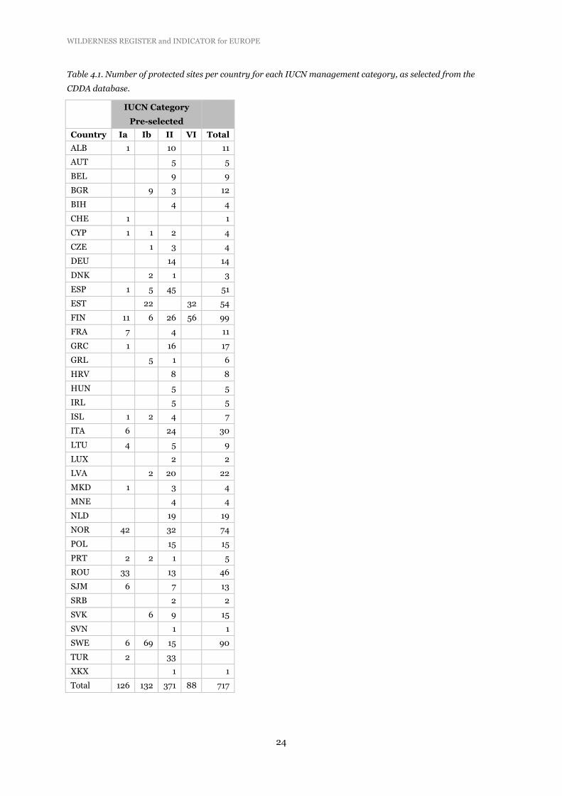
Table 4.1. Number of protected sites per country for each IUCN management category, as selected from the
CDDA database.
IUCN Category
Pre-selected
Country Ia Ib II VI Total
ALB 1 10 11
AUT 5 5
BEL 9 9
BGR 9 3 12
BIH 4 4
CHE 1 1
CYP 1 1 2 4
CZE 1 3 4
DEU 14 14
DNK 2 1 3
ESP 1 5 45 51
EST 22 32 54
FIN 11 6 26 56 99
FRA 7 4 11
GRC 1 16 17
GRL 5 1 6
HRV 8 8
HUN 5 5
IRL 5 5
ISL 1 2 4 7
ITA 6 24 30
LTU 4 5 9
LUX 2 2
LVA 2 20 22
MKD 1 3 4
MNE 4 4
NLD 19 19
NOR 42 32 74
POL 15 15
PRT 2 2 1 5
ROU 33 13 46
SJM 6 7 13
SRB 2 2
SVK 6 9 15
SVN 1 1
SWE 6 69 15 90
TUR 2 33
XKX 1 1
Total 126 132 371 88 717

WILDERNESS REGISTER and INDICATOR for EUROPE
25
4.2.4 Countries missing
BIH (Bosnia-Herzegovina): has not assigned IUCN categories to most of their protected areas, with
only a few exceptions (where categories II and V are used);
GBR (United Kingdom): has protected areas designated mainly under IUCN categories IV and V only;
TUR (Turkey): has not assigned IUCN categories to any of their protected areas in CDDA vs. 9, but in
CDDA vs. 8 it has; therefore, this previous version was used for Turkey.
4.2.5 Set of measurable criteria for verification
Derived from the working definition ( paragraph 1.2), a set of measurable criteria was developed. This
allowed us to judge if a protected site has sufficient wilderness qualities in line with the working
definition for wilderness.
Wilderness qualities are related to scale, naturalness of landscape features and habitats, remoteness
from access and settlement, and absence of any form of human interference..
Therefore, for inclusion in the wilderness register, information is needed on the following attributes:
a) zonation
b) size of the core zone with non-intervention management
c) extent of management measures (e.g. restoration) and human interference
Forms of human interference affecting wilderness qualities can be:
d) habitation/settlements/resorts for tourists
e) road building/motorised access
f) extraction of natural resources (logging, fishing, hunting, grazing with domestic stock, mining,
etc.)
g) habitat management
h) wildlife management (e.g. culling)
For compilation of the wilderness register, this list of attributes was translated to a set of measurable
criteria (Table 4.2):

WILDERNESS REGISTER and INDICATOR for EUROPE
26
Table 4.2 Set of measurable criteria used for qualifying protected areas as ‘wilderness’.
Core zone The core zone measures at least 3,000 hectares, there
can be two or more cores in the area (adding up to a
surface of at least 3,000 ha), if linked and with a plan
for full amalgamation.
Effective ecological functioning of natural processes Of sufficient size for the effective ecological functioning
of natural processes, for the preservation of biodiversity
and the maintenance of evolutionary processes.
Undeveloped or only slightly modified A high degree of ecological intactness, with a large
percentage of original ecosystems and complete or
near-complete native floral and faunal species
assemblages.
No habitation Without habitation or permanent settlements.
No infrastructure The area should be free of modern infrastructure or
development; no pipelines, power lines, or cell phone
towers; no roads or a plan for removal of existing
infrastructure; except traditional gathering sites
required by indigenous people to practice their
traditional reindeer herding; in Finland wilderness
legislation already exists to permit certain activities,
and these cannot thus be legally excluded.
No motorised access Preferably highly restricted or no motorised access.
Areas are only free to public access on foot; no wheels
or motorised access for recreational use; only access is
allowed in cases of emergency for safety reasons or for
law enforcement (ranger service).
No habitat management No interference that affect natural habitats and
processes.
Wildfire control Only if needed for e.g. public safety.
No wildlife management None, except by exceptional agreements under existing
wilderness legislation in Nordic countries, so long as
there is no significant impact on biodiversity. No re-
stocking except for restoration purposes.
No livestock None, except in exceptional circumstances for
indigenous people (only in Nordic countries, where
wilderness legislation exists and reindeer herding is
included).
No extraction of natural resources No commercial extraction of natural resources; no
collecting of berries, nuts, mushrooms, wood, fish etc.;
except by special agreements for indigenous people in
Nordic countries; in case of extensive and local
livestock grazing or fishing, there should in any case be
no significant impact on biodiversity.
Tourism and recreation Activities allowed if not requiring built infrastructure.
Tourism activities permitted under strict ‘leave no

WILDERNESS REGISTER and INDICATOR for EUROPE
27
trace’ rules. There should be no ecological impact.
Ample opportunities to experience ‘sense of solitude’.
Zoning
In some countries, such as Estonia, management categories are allocated to each different
management zone within a designated area. In several other countries, categories Ia/Ib are embedded
in IUCN management categories II or V36. This means that in statistics on protected areas there is
‘doubling’. In those cases, the sub-areas were added in the Register, with additional information on
zoning and on those protected areas in which they are embedded.
Infrastructure
The issue of ‘no infrastructure’ in the wilderness definition is interpreted as follows:
Infrastructure in wilderness areas:
a) Soft tourism infrastructure offering opportunity for visitors to experience wilderness e.g.
trails, bridges, sign, shelters, etc. To certain extent this is possible also in wilderness area
but have to respect certain rules e.g. minimise visual disturbance.
b) Infrastructure used for PA/wilderness zone management purpose e.g. old roads, cabins,
etc. Exceptionally use of existing old gravel road in large and remote wilderness areas e.g.
northern part of Scandinavia for monitoring, patrol, safety and rescue.
c) Existing infrastructure of regional/national/international purpose e.g. power lines, water
dams and reservoir, etc. Generally these infrastructures should not be inside of wilderness
areas but it’s likely that some exception will comes sooner or later e.g. power lines crossing
wilderness areas.
Infrastructure outside of wilderness areas but visible from wilderness areas:
This might be the case in some areas, not only in mountainous areas such as the Alps, but
everywhere with open landscape. This is a rather complex issue. Wilderness in Europe is
extremely scarce and with this additional criteria of "non-visibility" it will be even less.
Therefore it’s argued that the visibility of regional/national/international infrastructure from
wilderness areas should not be a decisive reason to not qualify a protected area as wilderness
area. In specific cases we plea to use ‘common sense’ to deal with this issue.
In many sites with wilderness qualities there are some forms of infrastructure present. It is important
to know whether roads are used only for management purposes or also for the public. We tried to gain
information for each potential wilderness areas for this particular point. Mostly this kind of
information is not available to NGOs, and sometimes not even in management plans if available.
Therefore, this criterion was rather difficult to interpret correctly.
Indigenous people and subsistence use of natural resources
In Nordic countries ‘wilderness’ may include some forms of traditional land use from local and
indigenous people. Indigenous communities can maintain their traditional wilderness-based lifestyle
in wilderness areas. Reindeer herding is considered part of the indigenous cultural heritage.and is
under existing wilderness legislation allowed almost everywhere in the Nordic region. This is the
36 EEA (2012). Protected areas in Europe –an overview. EEA Report No 05/2012. Copenhagen. 130 p.

WILDERNESS REGISTER and INDICATOR for EUROPE
28
traditional way of the Sámi people.. In Finland, reindeer grazing is allowed by the Reindeer Husbandry
Act in their Wilderness Reserves and other PAs within the Reindeer Husbandry Area. The (statutory)
primary objective for establishment of the Finnish Wilderness Reserves established under the
Wilderness Act (1991), was originally not protection of biodiversity, but preservation of wilderness and
traditional subsistence livelihoods of the indigenous Sámi and other locals in Lapland.
The reindeer herding has some disturbing elements, especially when motorised vehicles, such as
snowmobiles are used. But there are areas, however, where the impact on habitats is small. It cannot
be compared, however, with livestock grazing which mostly alters natural habitats.
With the revised Guidelines for Applying IUCN Protected Area Management Categories (2008) came
sharpened definitions for PAs and clear explanations for the interpretations of management
categories. Interpretation of definitions in the Nordic context was discussed with experts and
managers as well as NGOs at seminars in 2012. The IUCN Guidelines from 200837 allow for a less
strict interpretation of category Ib, compared to the 1994 definitions and interpretations in subsequent
guidelines (e.g. EUROPARC & IUCN 200038).
Grazing
Grazing is a rather complicated issue We followed the argument, as written down in the Wilderness
definition document (WWG), that no grazing with livestock is allowed in wilderness core zones, or
there should be clear plans for phasing out in short time. Traditional reindeer grazing as practiced by
indigenous people in the Nordic countries is formally allowed (Sámi rights) under existing wilderness
legislation.
Wildlife management
In many PAs qualifying for wilderness, there are some forms of wildlife management, i.e. hunting,
especially in national parks. The absence of large predators results in growing populations of wild
ungulates species if no population management is applied. The management of these populations is
obviously a contradiction to the effort to increase the naturalness of these areas. Controlled hunting,
however, is in many of these national parks permitted in an effort to keep some control on the
populations. Therefore, it is important to know if no hunting occurs in the core zone(s).
Another aspect is the ‘right to hunt’ which is often the result of the right of free access to public land
and traditional land-use, a common practice in Nordic countries, permitted by wilderness legislation.
Tourism and infrastructure
Wilderness areas have high landscape and amenity values and for their aesthetic benefits they are
often highly preferred destinations for nature tourism, i.e. tourism relying primarily on the natural
environment for its attractions or settings. In most wilderness areas tourism and recreation are
allowed but under strict conditions and without any built infrastructure. The development of a zoning
system to steer visitor pressure while still allowing visitors access to certain parts of the area with
37 Dudley, N. (Ed.) (2008). Guidelines for Applying Protected Area Management Categories. Gland, Switzerland: IUCN. x +
86pp
38 http://data.iucn.org/dbtw-wpd/edocs/1999-048-2.pdf
WILDERNESS REGISTER and INDICATOR for EUROPE
29
specific provisions such as trails, has proven to be a successful approach. although not all wilderness
areas are suitable for recreation or ecotourism due to their fragile ecosystems.
Visual disturbance
To be able to have a ‘real wilderness experience’, it is important that there is no visual disturbance
related to human activities to provide a ‘sense of solitude’. From the information available for each PA,
this is one of the criteria most difficult to check at the European scale though local scale modelling has
included this as a key indicator (e.g. Scotland39). No hard criterion can be used here at this scale.
4.3 Stakeholder consultations
Stakeholder consultations were organised to acquire relevant additional data and ensure sufficient
quality of the data available. The most relevant stakeholders were national/local NGOs in 39 countries
and site managers of protected wilderness and wild areas (listed in Annex 2).
NGOs and local stakeholders
The preliminary list of protected sites, where wilderness qualities might occur, was sent to local NGOs
or other local stakeholders (at least one contact address per country) with the request to check the list
of protected areas for their country and to affirm those areas which have a wilderness core zone. For
each of those sites they were asked to fill in a data form (see Table 4.3 for an example) to provide
additional information. Thereby, it was possible to check if these sites fulfil the criteria set for
wilderness (paragraph 4.2.5). This form had a simple as possible design to maximise the response.
The contact points were also explicitly asked to add (protected) areas with wilderness qualities to the
preliminary list which are:
part of the CDDA database, but hidden in other IUCN management categories;
not in the CDDA database, but qualify as ‘wilderness’, for instance Natura 2000 sites which are
not registered in the CDDA database.
The working process is summarised in Figure 4.4.
39 Carver, S.J., Comber, A., McMorran, R. & Nutter, S. (2012) A GIS model for mapping spatial patterns and distribution of wild
land in Scotland. Landscape and Urban Planning 104(3-4), 395-409

WILDERNESS REGISTER and INDICATOR for EUROPE
30
Figure 4.4. The working process for compilation of a wilderness register for Europe.

WILDERNESS REGISTER and INDICATOR for EUROPE
31
Table 4.3. Data form to be filled in by national protected area data managers to check the presence of wilderness qualities in protected areas selected from the CDDA
database (categories Ia/Ib, II and VI/Finland). As example, the list for France.
CDDA Site code National code ISO3 Desig_abbr Site_name Site_area (ha) IUC
N_
cate
gory
IUC
N-U
NEP
WD
PA
web
site
1. S
tric
tly
pro
tect
ed a
rea/
wild
ern
ess
(co
re)
zon
e*
3. H
abit
atio
n/s
ettl
emen
ts/r
eso
rts
4. M
oto
rise
d a
cces
s
5. H
abit
at m
anag
emen
t
6. W
ildlif
e m
anag
emen
t
7. E
xtra
ctiv
e u
se o
f re
sou
rces
8. G
razi
ng
wit
h d
om
esti
c st
ock
9. R
oad
bu
ildin
g al
low
ed
10
. Sp
atia
l dat
a av
aila
ble
(e.
g. s
hap
efile
s)
11
. Nat
ura
20
00
sit
e
12
. If
yes,
pro
vid
e N
atu
ra 2
00
0 s
ite
cod
e
y/n <25% 25-75% >75% y/n y/n y/n y/n y/n y/n y/n y/n y/n
659 FR3300005 FRA FR01 Ecrins 91,800 II http://www.protectedplanet.net/sites/Ecrins_National_Park_Core_Area
664 FR3300006 FRA FR01 Mercantour 68,500 II http://www.protectedplanet.net/sites/Mercantour_National_Park_Core_Area
661 FR3300001 FRA FR01 Vanoise 52,839 II http://www.protectedplanet.net/sites/Vanoise_National_Park_Core_Area
662 FR3300003 FRA FR01 Pyrénées Occidentales 45,705 II http://www.protectedplanet.net/sites/Pyrenees_Occidentales_National_Park_Core_Area
345948 FR2400196 FRA FR06 Sylve d'Argenson 2,579 Ia http://www.protectedplanet.net/sites/Sylve_D_Argenson_Forest_Biological_Reserve
391970 FR2400199 FRA FR06 Les Maures 2,531 Ia
142747 FR2400132 FRA FR06 La Wantzenau ? Ia http://www.protectedplanet.net/sites/La_Wantzenau_Forest_Biological_Reserve
388657 FR3500001 FRA FR02 Lauvitel ? Ia
388658 FR3500002 FRA FR02 Ilots de Port-Cros ? Ia
345944 FR2400193 FRA FR06 Bois Sauvage ? Ia http://www.protectedplanet.net/sites/Bois_Sauvage_Forest_Biological_Reserve--2
330613 FR2400164 FRA FR06 Daubensand ? Ia http://www.protectedplanet.net/sites/Daubensand_Forest_Biological_Reserve--2
Note: question 2-12 are related to the strictly protected (wilderness) core zone, if present
If there is no non-intervention management zone, questions 2-12 can be skipped
2. I
f ye
s, %
of
tota
l are
a

WILDERNESS REGISTER and INDICATOR for EUROPE
32
In the consultation process, 22 local stakeholders from 23 countries have commented on the pre-
selection of protected areas with potential wilderness qualities, have provided additional information
and have made amendments to the preliminary list of selected PAs (see Annex 2 for a list of NGOs
involved in the consultation process).
Site managers
For those countries for which no response was received from stakeholders (16), individual site
managers of protected areas on the list of pre-selected protected areas were contacted. A total of about
100 site managers were requested to provide information on wilderness qualities in their particular
protected area. Their response was ca. 50%. They provided detailed information for specific protected
areas.
Based on these stakeholder consultations, information on wilderness qualities of protected areas was
received for 72% of the pre-selected PAs, thereby ensuring the quality of available data for a large part
of pre-selected PAs.
The data forms returned by local stakeholders and site managers are summarised in Annex 4.
4.3.1 Short list of confirmed PAs with wilderness qualities
Category A (wilderness)and B (wild area)
If for a certain protected area all attributes were in accordance with the wilderness definition (highest
possible score: 8), it was nominated as ‘wilderness area’ (category A). In most occasions, however,
there were deviations. Those protected areas with a score of at least 5 were nominated as protected
areas with a potential to become wilderness , after certain measures have been taken. These areas are
qualified as ‘wild area’ and conform the definition presented in paragraph 1.2:
“Wild areas have a high level of predominance of natural processes and natural habitat. They tend to
be more fragmented than wilderness areas, although they often cover extensive tracts. The condition
of their natural habitat, processes and relevant species is, however, often partially or substantially
modified by human activities such as livestock herding, fishing, forestry, sport activities or general
imprint of human artefacts40.”
From the viewpoint of maintaining and increasing wilderness qualities in Europe, and localisation of
opportunities for wilderness extension, it is important that these ‘category B’ areas (wild areas) are
also included in the database supporting the wilderness register, with an indication of actions to be
taken to transform them into wilderness areas (category A).
As such, the compilation of a database composed of category A and B protected areas harbouring
wilderness qualities, can benefit protection and restoration of wilderness and wild areas.
Technical working procedure
40 Wild Europe (2012). A Working Definition of European Wilderness and Wild Areas. October, 2012.

WILDERNESS REGISTER and INDICATOR for EUROPE
33
Four main criteria were used to differentiate between category A and B, i.e. size, extractive use,
subsistence use and infrastructure (Table 4.4). Visual disturbance is also an important aspect affecting
the experience of wilderness, but we could not include this as criterion because of lack of available
information (see also paragraph 4.2.5).
Table 4.4 Main criteria used to distinguish between category A and B.
Issue Category A Category B
Size minimum 3,000 ha less than 3,000 ha (but with
potential to expand)
Extractive use none yes
e.g. extensive hunting, fishing,
collecting berries and grazing
(but with potential to reduce
and remove these uses)
Subsistence use none; with the exception of
traditional reindeer herding as
practiced by indigenous people in the
Nordic countries which is formally
allowed (Sámi rights) under existing
wilderness legislation
yes
e.g. subsistence hunting,
fishing, collecting berries and
grazing (but with potential to
reduce and remove these
subsistence uses)
Infrastructure none (certain compromises are
necessary, e.g. existing/old gravel
road used for safety, fire control,
management, etc.)
yes
e.g. existing roads (but with
potential to reduce and/or
remove them)
Category A/B
For six countries with large wild areas, i.e. Finland, Sweden, Norway, Iceland, Greenland and
Svalbard/Jan Mayen, we distinguished the wilderness category A/B. Large parts of these areas qualify
as category A, but in certain parts there is subsistence use (livestock grazing, fishing, hunting). Because
these countries do not apply any zonation in wilderness management, it is not possible to present
boundaries between those parts where the criteria set for category A wilderness are fully met, and the
parts which should be qualified as category B (wild area). These areas are qualified as category A/B.
4.4 Verification by National Focal Points
The consultation of NGOs and site managers resulted in a short list of protected areas for each
country, qualifying for wilderness, which was checked by the data reporters of the National Focal
Points (NFPs; see Annex 4). For each of the 39 EEA members a request for verification of the data in

WILDERNESS REGISTER and INDICATOR for EUROPE
34
the draft register was send to the national contact person. Until the end of the contract (30 June 2013),
response was received from 24 countries. Although a reminder was send, verification stayed pending
for 15 countries (for further details see Annex 3).
4.5 Draft wilderness register
The draft wilderness register is made available as MS Access data file. The database encompasses two
tables:
a ) a list of PAs qualifying as either wilderness category A, A/B or B with their Natura 2000 status;
b) a table with details on wilderness attributes as confirmed by site managers, NGOs, local
stakeholdersand National Focal Points.
The draft register encompasses 522 PAs. Besides category Ia/Ib, a substantial number of PAs with
wilderness qualities occur within the core zones of national parks (category II; Table 4.5). Each PA has
the CDDA code attached as unique identifier by which it can be linked to the CDDA database.
A total of 284 protected areas are qualified as wilderness category A (or A/B), and another 238 sites of
category B. (Table 4.6). Most wilderness areas occur in Finland, Sweden, Norway, Bulgaria, Slovakia,
Poland and Romania (Table 4.6; Fig. 4.5).
Detailed information on wilderness qualities of specific protected areas is for each country
summarised in Annex 4. Here, all background information can be found on the decision to qualify
certain PAs either as category A, A/B or B.
Table 4.5 Number of protected sites with wilderness qualities per IUCN management category.
Wilderness category Ia Ib II VI others total
A 14 34 27 - 1 76
A/B 56 40 66 45 1 208
B 46 54 105 9 24 238
Total 116 128 198 54 26 522
Table 4.6 Number of protected sites with wilderness qualities (category A, A/B or B) per country.
Country EU 27 Cat. A Cat. A/B Cat. B Total
ALB 3 3
AUT + 11 11
BGR + 22 20 42
BIH 10 10
CHE 1 1
CZE + 1 1 2
DEU + 1 13 14
ESP + 3 3
EST + 9 8 17
FIN* + 4 79 16 99

WILDERNESS REGISTER and INDICATOR for EUROPE
35
FRA + 3 3
GRL* 6 6
GRC + 2 2
HRV + 4 1 5
ISL* 1 6 7
ITA + 2 13 15
LTU + 3 4 7
LUX + 1 1
LVA + 3 3
MKD 2 2
MNE 6 6
NLD + 5 5
NOR* 1 72 73
POL + 6 16 22
PRT + 1 3 4
ROU + 6 14 20
SJM* 13 13
SRB + 1 1
SVK + 26 26
SWE + 1 32 52 85
TUR 1 13 14
Total 76 208 238 522
EU27 + 72 111 201 384
*These countries do not apply core areas/zonation in their protected areas. So far, it was not possible to provide spatial
information on the boundaries of sub-areas with wilderness A qualities. These PAs are therefore categorised as A/B.
WILDERNESS REGISTER and INDICATOR for EUROPE
36
Figure 4.5 Number of wilderness areas (Cat. A, A/B) and wild areas (category B) per country.

WILDERNESS REGISTER and INDICATOR for EUROPE
37
Table 4.7 Cover of wilderness areas (in hectares) per country.
Site areas Core areas Site areas Core areas
Estimated core areas
(total)* A A A/B A/B
ALB
AUT 154,804 78,765 78,765
BGR 54,626 54,626 54,626
BIH
CHE 17,033 17,033 17,033
CZE 3,615 3,615 3,615
DEU 24,217 12,593 12,593
ESP
EST 39,281 39,281 39,281
FIN 97,599 2,876,546 1,802,663
FRA
GRC
GRL 98,724,420 58,513,889
HRV 56,620 38,494 38,494
ISL 6,559 6,559 1,459,301 891,058
ITA 133,882 59,885 59,885
LTU 55,502 26,223 26,223
LUX
LVA
MKD
MNE
NLD
NOR 5,800 5,800 3,330,649 2,024,544
POL 159,912 52,601 52,601
PRT 69,593 5,000 5,000
ROU 72,968 39,277 39,277
SJM 11,782,813
SRB 19,200 2,963 2,963
SVK
SWE 38,440 22,140 3,460,424 2,119,542
TUR 37,000 15,758 15,758
1,046,651 480,613 121,634,153 65,647,266
EU27 980,259 435,463 6,336,970 3,499,124
*The ratio core area/total area is estimated as 48% (based on the average ratio for those PAs where information on core zones is
available).

WILDERNESS REGISTER and INDICATOR for EUROPE
38
Figure 4.6 Map of wilderness areas (Category A and A/B) included in the draft wilderness register.

WILDERNESS REGISTER and INDICATOR for EUROPE
39
4.6 Overlap with Natura 2000
For the Member States of EU27, most wilderness category A areas are part of the Natura 2000
network (>99%). To assess the spatial overlap, GIS-based information is needed on wilderness and the
geographical location of strictly protected areas/core zones within each wilderness area. This
information is not made available yet.
The total cover of the core zones of wilderness areas (category A and A/B) in EU 27 is estimated at
3,500,00041 hectares (n=183 PAs; Table 4.7), which makes up about 4.5% of the total Natura 2000
network (total terrestrial cover 76,800,000 ha; status end 201142).
4.7 Discussion
Although data availability on wilderness qualities in protected areas throughout Europe was strongly
increased with the assistance of local stakeholders, the draft wilderness register needs improvement.
For practical reasons we have chosen to use the CDDA database as starting point for the analysis of
wilderness qualities in protected areas of Europe for the Wilderness register. This is the only
European-wide database with information on conservation objectives. This brings the risk that
wilderness areas which are not registered in the CDDA (but eventually in Natura 2000 database) were
missed in the inventory, especially for those countries were there is small overlap between these two
databases (see Fig. 2.1), such as Bulgaria, Cyprus, Ireland, Portugal, Romania, Spain. This point is
further discussed in paragraph 5.9.2.
For the data we were dependent on information provided by stakeholders and National Focal Points.
However, for certain countries no response was received on requests for information on specific
protected areas. This resulted in a lack of data for these countries. This was partly overcome by
approaching individual site managers for those countries where no information was received.
However, a lack of data persisted in particular for Greenland, Ireland, Iceland, Lithuania,
Luxembourg, Romania, Svalbard/Jan Mayen, Slovenia, Turkey and Kosovo.
41 The size of the wilderness core zone was known for 73 PAs; the unknown core areas were estimated as 49% of the total area
(same ratio as those PAs with known core area within the EU27). 42 EEA (2012). Protected areas in Europe –an overview. EEA Report No 05/2012. Copenhagen. 130 p.

WILDERNESS REGISTER and INDICATOR for EUROPE
40
5 Proposal for a wilderness indicator
5.1 Objective
For the purposes of policy development and decision making, areas and regions with wilderness
conditions have to be identified. The aim was to make a draft biodiversity indicator on wilderness,
based on a multifunctional spatial analysis,.
The indicator is based on spatial landscape features which make the presence of wilderness conditions
likely, and is built upon four key-wilderness aspects derived from the wilderness working definition,
i.e. naturalness of land cover and vegetation, remoteness from settlements, remoteness from access,
and terrain ruggedness. Where the register is a tabular database with information on protected areas
with wilderness qualities, the wilderness indicator is an index based on a combination of different
landscape features related to wilderness. A high index value for a certain area or region indicates a
high potential that wilderness conditions occur at that location.
The methodology used is building further on previous work carried out on wilderness indicators at
various scales from global (e.g. Sanderson et al., 2002 and the Human Footprint43), to European (e.g.
the draft maps produced for Prague May 2009 and the EEA Mountains Report 201044), to member
states (e.g. Scotland, Austria, Iceland, Norway, etc.) and individual parks/regions (e.g. Romania
Carpathians, Scottish National Parks; further illustrated in paragraph 5.8.2).
The indicator for wilderness is developed for:
a) monitoring of changes in wilderness conditions and potential over time in Europe;
b) identification of existing wilderness areas in different regions of Europe, which might
encompass also unprotected areas.
The wilderness indicator has a format of a 1 x 1 km resolution raster dataset, showing wilderness
quality on a linear scale between 0-100.
In order to produce a widely accepted spatial analysis product and to make the product coherent with
existing EU biodiversity indicators, the analysis needed to be based as much as possible on datasets
available from the Biodiversity Data Centre (BDC) and the Biodiversity Information System for Europe
(BISE).
A multi-scale approach is chosen, with wilderness quality mapped at a European scale using the best
available and consistently mapped European-wide data, followed by a lower tier of several national
scale maps, using national data. When possible and data are available, a third tier of mapping might
involve high resolution, local level mapping for individual protected areas. By using national/regional
mapping examples of well-known wilderness areas, the actual (mapping) aspects of wilderness can be
explored in detail.
43 Sanderson, E.W., M. Jaiteh, M.A. Levy, K.H. Redford, A.V. Wannebo &G. Woolmer (2002). The Human Footprint and the
Last of the Wild. Bioscience 52: 891-904. 44 EEA (2010) Europe’s ecological backbone: recognising the true value of our mountains. EEA report no 6/2010, Copenhagen;
Paragraph 10.3 Mountains and wilderness; pp. 192-201.

WILDERNESS REGISTER and INDICATOR for EUROPE
41
Spatial analysis related to this indicator was developed in close co-operation with the relevant
stakeholders, most importantly the EEA, in order to meet the objectives set for European biodiversity
indicators. It guarantees that the indicator (and register) is relevant and tailor-made for DG
Environment policy needs.
Paragraphs 5.2-5.4 describe the main datasets involved. Paragraphs 5.5-5.6 give a methodological
description of the compilation of the draft wilderness indicator. Additionally, recommendations are
provided for updating the indicator and how to fill gaps in data availability.
5.2 Exploration of relevant datasets
The most relevant datasets for the spatial analysis of wilderness qualities throughout Europe have
been explored and the need for processing these datasets was investigated.
Datasets to be used for the development of the indicator had to be:
consistent across national boundaries throughout the European territory;
with a sufficient and coherent spatial resolution (lowest resolution for a EU coverage =1 x 1
km);
preferably not being restricted to EU15/EU27, but cover also non-EU countries and edges of
adjoining countries (e.g. Russia) as to avoid edge effects;
showing the probability to adapt and implement the draft indicator at different scales, where
needed.
According to previous work on wilderness mapping carried out by WRi/University of Leeds (Fisher et
al. 201045, Carver et al. 201246), the four most relevant aspects of wilderness in a European wide
context are:
Naturalness of land cover –natural vegetation and land cover, largely undisturbed by human
interference;
Remoteness from settlement / absence of human influence - The absence of obvious artificial
forms or structures within the landscape can at the European level be calculated by selecting
those areas which have a very low access from population, which can be seen as a proxy of
human disturbance;
Remoteness from access –based on time needed to enter an area from the nearest point of
mechanised access;
Ruggedness of terrain: rugged and challenging character of the terrain – the physical
characteristics of the landscape including effects of steep and rough terrain and harsh weather
conditions often found at higher altitudes.
For mapping, these four sub-indicators are combined using a combination of linear multi-criteria
evaluation (MCE) and fuzzy methods. They are combined into a single wildness indicator, applicable at
the European scale.
45 Fisher, M., Carver, S. Kun, Z., McMorran, R., Arrell, K. & Mitchell, G. (2010). Review of Status and Conservation of Wild Land
in Europe. Project commissioned by the Scottish Government. 46 Carver, S, A. Comber, R. McMorran & S. Nutter, 2012. A GIS model for mapping spatial patterns and distribution of wild land
in Scotland. Landscape and Urban Planning 104 (2012) 395– 409

WILDERNESS REGISTER and INDICATOR for EUROPE
42
5.3 EU-wide datasets
Starting point was the exploration of methodology and datasets stored under BDC and BISE used for
EEA's Net Landscape Ecological Potential (NLEP). These included datasets on:
a) GBLI: land use (green background landscape index based on CORINE/CORILIS).
b) NATURILIS_COMB: designation status (Natura 2000/CDDA/EMERALD data on protected
areas).
c) MEFF: landscape fragmentation (effective mesh size).
We explored which additional data were needed for a coherent and ecologically meaningful picture of
wilderness in Europe, related to the main qualities of wilderness, i.e. the predominance of natural
processes, remoteness and unaffectedness by human interference. Sub-paragraphs 5.3.1. – 5.3.3.
describe the possibly relevant and available EU-wide datasets for the calculation of a wilderness
indicator. Not all datasets named here were necessarily used in the final calculation, but it was felt that
it was important to mention them as a potential source of information.
5.3.1. Datasets on population density
Datasets providing information on population density are:
GEOSTAT_Grid_POP_2006_1K European population grid dataset: this dataset contains total
population figures for the reference year 2006, disaggregated to a 1 km² grid. The 2006
population grid map is an estimation which is based on different datasets - 2011 Census
building centroids, persons address data from population register, data about new buildings
from buildings register and the official 2006 population counts on municipalities level.
(http://www.efgs.info/data/geostat/open-data)
AIT disaggregated European population grid for 2006 1 km²: this dataset contains also total
population figures for the reference year 2006, disaggregated to a 1 km² grid. The dataset has
been produced by the Austrian Institute for Technology (AIT). Data cover: EU 27 and EFTA
countries (except Cyprus, no LAU population figures for CY). The source population data is
reported on LAU2. The main ancillary dataset is the GMES soil sealing layer 2006.
(http://www.efgs.info/data/geostat/open-data)
Both can be combined with:
EuroGeographics Regional database (EUROREGIONAL) with the settlements layer for e.g.
calculation of remoteness of small islands or with figures of GDP to calculate economic density
maps (see Metzger et al. 201047).
5.3.2 Datasets on landscape fragmentation and infrastructure
Available datasets that provide information on the biophysical intactness and or the remoteness of
landscape and vegetation are:
47 Metzger, M.J., R.G.H. Bunce, M. van Eupen, & M. Mirtl (2010) An assessment of long term ecosystem research activities
across European socio-ecological gradients. Journal of Environmental Management 91: 1357-1365.

WILDERNESS REGISTER and INDICATOR for EUROPE
43
MEFF: landscape fragmentation (effective mesh size) EEA/Landscape fragmentation 2009:
Remoteness, and thus fragmentation by infrastructure (road, railway and to a certain extent
waterways), is a relevant issue. The here used mesh size can be of direct value for describing
the fragmentation of protected areas although the 1 km resolution could possibly be too coarse
to link it directly to all Natura 2000/CDDA/EMERALD data. This was explored.
o three fragmentation datasets (based on three different geometries are published as
GIS- layers: http://www.eea.europa.eu/data-and-maps/figures/landscape-
fragmentation-per-km-data
The concept of the FARO Urban-Rural typology (Eupen et al. 201248), calculating the average
remoteness from urban centers for (six) classified sizes of cities (varying from small (20,000)
to large (750,000) inhabitants). For these or comparable remoteness calculations, a road
network and urban nodes should be available (see below).
Infrastructure Database: Roads/Railways/Navigable rivers :
o TeleAtlas. This database was used to calculate the MEFF. Preferably we use the
TeleAtlas data if available directly from the Commission (but EEA has not prolonged
their contract);
o Alternative for using the Teleatlas database is the Roads layer from the
EuroGeographics Regional database (EUROREGIONAL map – 1:250 000 scale
topography dataset covering 31 countries (EU27 exclusive Bulgaria; for Bulgaria only
the EuroGlobalMap – 1:1 million scale topography is available).
o Open source: Open Street Map. The OpenStreetMap Project (OSM) based at
OpenStreetMap.org, is the worldwide mapping effort that includes more than half a
million volunteers around the globe. OSM is an open initiative to create and provide
free map data to anyone who wants them. OSM can be used in addition to other
databases were no coverage exist. Depending on the region data can be less accurate
and/or more fragmented.
5.3.3 Datasets on naturalness of land cover and vegetation
CORINE/NLEP/Corilis (EU27 + NO + CH + TR: EEA/CORINE 2000 (GRE) & 2006 (Rest)).
o Additionally, we explored the GBLI from NLEP: land use (green background
landscape index based on CORINE/CORILIS). Although this dataset is including all
pastures-forest and other nature areas (where pastures are not considered as
wilderness areas), the conceptual approach was explored. Since the rules to create the
index are not clearly covering the scope of wilderness indicator, but more a greenness
indicator only the basic datasets to create this index (CORINE) was used to prevent
misinterpretation of the results.
o NATURILIS from NLEP: the used thresholds for creating NATURILIS (5 km) were
considered not being valid for designating wilderness areas generally over Europe,
48 Eupen, M. van, M.J. Metzger, M. Pérez-Soba, P.H. Verburg, A. van Doorn, A. & R.G.H. Bunce (2012). A Rural Typology for
Strategic European Policies. Land Use Policy 29: 473-482.

WILDERNESS REGISTER and INDICATOR for EUROPE
44
although since it is a simple measurement, a comparable approach was by combining
datasets with a fuzzy approach (see paragraph 5.5).
Tree species maps for European forests: showing the main forest type areas in Europe (Brus et
al. 2011 EFI/Alterra49). Conclusion: Since the map just showed the forecasted main species-
type and not species management/naturalness, the map was considered of less value for the
wilderness indicator.
Global Livestock Production and Health Atlas (GLiPHA, http://kids.fao.org/glipha/). GLiPHA
is an interactive, electronic atlas containing global animal production and health statistics.
Sub-national statistics relating to the livestock sector can be viewed cartographically, against a
back-drop of selected maps, such as livestock densities, land-use and topography. Based on
EUROSTAT and FAO census statistics the FAO created maps with the amount (heads) of cattle
and sheep and goats grazing per gridcell (5’ x 5’). Dataset can be used to show the land use
intensity part of the (CORINE) land cover database50.
EURODEM51 (topography data for Europe), height above sea-level. To be used in combination
with land cover data and to use to calculate terrain roughness (for both remoteness and
naturalness). Alternative for using the standard GTOPO/SRTM/ASTER-DEM data.
The LANMAP2 dataset (Landscape Map for Europe (Alterra, 2007)) is of value when there is a
possibility or need for selecting region specific thresholds for wilderness values (see par.
5.5).52. LANMAP2 is a hierarchical classification with four levels and has 350 landscape types
at its lowest level (level 4), The first level of the classification is determined by climate and has
only eight classes. The second level is determined by climate and topography and has 31
classes. The third level, determined by climate, topography and parent material has already 76
classes.
CDDA: The European inventory of nationally designated areas holds information about
protected sites and about the national legislative instruments, which directly or indirectly
create protected areas. The dataset contains data on individual nationally designated sites and
of EEA member and collaborating countries. The extended version of the public CDDA
database can be used, showing insight in the location and designation status of the
collaborating countries.
Natura 2000 is an ecological network composed of sites designated under the Birds Directive
(Special Protection Areas, SPAs) and the Habitats Directive (Sites of Community Importance,
SCIs, and Special Areas of Conservation, SACs). The descriptive database also pairs with a
spatial database. Borders of sites submitted by each Member State are validated by the
European Environment Agency (EEA) and linked to the descriptive data53.
GLOBCORINE: bordering the EU 27 (where no-CLC land cover data exist) we propose to use
the Globcover Land Cover database (V2.3 200954): GLOBCOVER was launched in 2004 as an
initiative of the European Space Agency (ESA) which aims to produce a new global land cover
49 Brus, D.J., G.M. Hengeveld, D.J.J. Walvoort, P.W. Goedhart, A.H. Heidema, G.J. Nabuurs & K. Gunia, 2011. Statistical
mapping of tree species over Europe. European Journal of Forest Research 131 (1): 145–157.
50 This map will/can be replaced in the near future by work to be published soon by EEA (pers. note Óscar Gómez Prieto (EEA)) 51 http://www.eurogeographics.org/content/products-services-eurodem 52 http://www.alterra.wur.nl/NR/exeres/6DA551F0-D7A6-45C6-A499-AC6B80FB82EB;
http://content.alterra.wur.nl/internet/webdocs/internet/geoinformatie/projects/LANMAP2/Metadata-LANMAP2_ud.pdf
53 http://www.eea.europa.eu/data-and-maps/data/natura-2000 54 http://www.efi.int/portal/virtual_library/information_services/mapping_services/tree_species_maps_for_
european_forests/ https://globcover.s3.amazonaws.com/LandCover2009/Globcover2009_V2.3_Global_.zip;
https://globcover.s3.amazonaws.com/LandCover2009/GLOBCOVER2009_Validation_Report_1.0.pdf

WILDERNESS REGISTER and INDICATOR for EUROPE
45
database based upon fine resolution pictures (300 m) from the ENVISAT satellite. By using
this dataset, less so called “border effects” will be visible compared to the use of no-data55.
5.4 Regional datasets for the analysis of wilderness
UK/Scotland:
Example 1: Data used in the Wildness Study in the Cairngorms National Park (Steve Carver,
Lex Comber, Steffen Fritz, Robert McMorran, Steve Taylor & Justin Washtell March 200856).
Example 2: Data and method used in: A reconnaissance level wild land map of the UK for the
John Muir Trust’s (Steve Carver, 2010).
Example 3: Data and method used in the Scottish Natural Heritage national wildness map for
Scotland (March 2012).
Austria:
o Example 4a: Data and method used in: MAPPING THE WILDERNESS OF THE ALPS – A
GIS-BASED APPROACH (Kaissl, 200257), a GIS-based study into the wilderness areas of
the Alps; understood as an area remote from/undisturbed by influences of modern society.
o Example 4b: Mapping used to derive the national Strategy to promote wilderness – Further
potential inside and outside N2000 areas. Michael Zika, WWF Austria, The conference
’Protecting Wilderness in Europe’ PAN Parks, 2012.
Romania:
o Example 5: Identification and mapping of wilderness areas in the South Western
Carpathians (Department of Geography/EPC Consulting, University of Bucharest).
55 Although with the use of this kind of datasets the extension of the wilderness indicator outside EU27 looked promising, it was
finally only possible to create a consistent map for EU27 + NO + CH due to the omission of several other consistent layers
outside EU27 (e.g. roads database). A separate more rough wilderness map could be made for areas outside EU 27 56 http://www.wildlandresearch.org/Cairngorm2008.pdf 57 http://www.panparks.org/learn/wilderness-resource-bank/mapping-the-wilderness-of-the-alps-a-gis-based-approach

WILDERNESS REGISTER and INDICATOR for EUROPE
46
Table 5.1. Datasets used for compiling the draft wilderness indicator for Europe.
Dataset Description Availability Spatial resolution Thematic accuracy Costs
GEOSTAT_Grid_POP_2006_1K European population grid dataset:
available 1 x 1 km LAU2 Free
EuroGeographics Regional database (EUROREGIONAL)
settlements layer Available EC 1: 50,000 Medium Free (needs EC permission)
EuroGeographics Regional database (EUROREGIONAL)
Road layer Available EC. Alternative for using the Teleatlas database
1: 50,000 High Free (needs EC permission)
Corine Landcover 2000/2006 (GRE) Land Cover database EU 27 + 2
Available. EU27 + NO + CH + TR: EEA/CORINE 2000 (GRE) & 2006 (Rest).
100 x 100 m High Free
GLOBCORINE (GLOBCOVER classified into the main CLC characteristics)
Land Cover database Europe
Available for Europe 300 x 300 m Medium Free
EURODEM (topography data for Europe),
height above sea-level. Available the EC? 100 100 Restricted, EC has no license
SRTM dem height above sea-level. Available 90 x 90 m High Free
AsterDEM V2 height above sea-level. Available 30 x 30 m High Free
CDDA The European nationally designated areas
Available EEA 1: 50,000 up to 1: 25,000
High, differences per member state
Free, but with restrictions
Urban Night lights Light from stable sources Available per month 90 x 90 m High Free
PNV Potential natural vegetation of Europe
(Böhn et al. 2000) 1: 2,500,000 High Free
FAO Global Livestock Production and Health Atlas (GLiPHA)
Grazing intensity Available for 2000 and 2006 5’x 5’ Medium Free

WILDERNESS REGISTER and INDICATOR for EUROPE
47
5.5 Mapping approach, combining indicators
The four sub-indicators: a) naturalness of land cover and vegetation b) remoteness from settlement, c)
remoteness from access and d) terrain ruggedness are combined to a draft wilderness quality index.
The applied method is a combination of fuzzy membership as e.g. described for calculating a
wilderness map in Combera et al. (201058), and linear multi-criteria evaluation (MCE) (Carver et al.
201259). This will be explained in more detail below.
5.5.1 Step 1: Scaling between 0-1 of all input layers
The process of transforming original input values to the 0 to 1 scale of possibility of membership is
called the fuzzification process (Comber et al. 2010). All the original input values of each input dataset
are transformed to the 0 to 1 scale (with 1 = maximum for the factor) of possibility of membership to
each specific wilderness criterion. This transformation can be done using various scaling techniques,
e.g. linear or with a Gaussian curve etc. (see text box). The major problem of fuzzy MCE can be that the
final output is more difficult to be interpreted and more challenging to lead back to the used input
thresholds. To keep the scaling process understandable, all four factors were scaled using a simple
linear relationship with a minimum and maximum threshold, where between the linear
transformation takes place. The choice of the used threshold value is very important. The main reason
to use minimum and maximum thresholds was to remove the outliers in the distribution of the values.
In this way the thresholds have no real ecological value, but are more used as technical way to improve
the scaling of the data. Each factor, for example distance to roads, ruggedness and land-use types, was
transformed (Fig. 5.1).
5.5.2 Step 2: Combining of the four factors
Second step in the mapping process is the combination of the four factors into one map. Simple MCE
(Multi Criteria Evaluation or MCA Analysis) is often used to meet a particular objective, evaluating
several criteria and consider their different levels of importance (Carver et al. 2012). Also here,
different methods of combining and weighing the data are possible. From again a purely fuzzy
approach to very simple linear weighed multi-criteria evaluation (MCE) will give different output
(Comber et al. 2010, Carver et al. 2012). Following the working definition of wilderness (paragraph
1.2), thresholds are not easy to set. This suits well with a method which results in a range of wildness
values compared with a map showing a single threshold of wilderness.
Since we like to keep the MCE process as transparent as possible, we choose to combine the fuzzy first
step of the MCE with a simple weighing of the four factors. The various sets of weights are applied
within a simple Weighted Linear Combination MCE model (Carver et al. 2002, 2012). By applying
58 Comber, A., S. Carver, S. Fritz, R. McMorran, J. Washtell & P. Fisher (2010). Different methods, different wilds: Evaluating
alternative mappings of wildness using fuzzy MCE and Dempster-Shafer MCE Computers. Environment and Urban Systems
34: 142–152. 59 Carver, S., A. Comber, R. McMorran & S. Nutter (2012). A GIS model for mapping spatial patterns and distribution of wild
land in Scotland. Landscape and Urban Planning 104: 395– 409.

WILDERNESS REGISTER and INDICATOR for EUROPE
48
specified factor weights, different wilderness maps can be generated, taking into account the
perception of wilderness and human disturbance (Carver et al. 2010).
For specific areas in the UK, thresholds were derived using people’s perception of wild areas (Carver et
al. 200260, 2012). These thresholds values, however, cannot simply be copied to the European context
/scale. The final output map was reviewed by confronting the values of the wilderness indicator with
the wilderness areas described in the wilderness register. Based on the comparison results, weighing
factors can be adjusted. Differential weightings to different layers/attributes in the wilderness
indicator will calibrate the indicator.
[P.M. update of the thresholds + map based on review of the areas in the Wilderness register. E.g.
regionalisation of thresholds]
Figure 5.1 Method applied for mapping of wilderness quality in Europe.
Based on the initial mapping output, combined with the results from the register, two rationales were
chosen for the final weighing:
If a sub-indicator equals zero in the fuzzy scaled maps, the final indicator will also equals zero;
this prevents that completely non-natural vegetated areas as farmland which is very remote or
very far away from roads will be classified as wilderness.
To keep the final output map as understandable as possible, the sub-indicators were
multiplied with each other with equal importance. This results in a final indicator value with a
60 Carver, S., A. Evans & S. Fritz (2002). Wilderness attribute mapping in the United Kingdom. International Journal of
Wilderness 8 (1).

WILDERNESS REGISTER and INDICATOR for EUROPE
49
scale of 1 (all sub-indicators have a score of 1) to zero (one or more sub-indicators have a score
of zero).
“Terrain ruggedness” is used both as separate sub-indicator and as factor in the calculation of
“remoteness from access” and “remoteness from population” (both using terrain ruggedness in
the friction surface). It was concluded that the weights for the sub-indicator “terrain
ruggedness” needed to be minimised; for that reason this sub-indicator was given a zero
weighing (left out) in the final MCE.
In summary, we applied a weighing in which naturalness of vegetation is weighed equally with
remoteness from settlement and equally with remoteness from access, and terrain ruggedness is only
used as parameter in the remoteness calculations.
5.6 Methods deriving maps for each factor
5.6.1 Naturalness of landscape and vegetation
From the point of view of naturalness of landscape and vegetation it seems straightforward to select
those (mapped) land use/ vegetation types which are undisturbed by man. The map showing the
natural vegetation of Europe (Böhn et al. 200061) gives an idea about what land cover types should be
selected to be considered as natural. The natural vegetation map itself could be used to check if
vegetation types can be seen as the most natural types but unfortunately the map is digitised on a
coarse 1: 1 / 2.5 mln. level, which makes it difficult to combine with higher resolution land cover layers
(Fig. 5.3).
61 Böhn, U., Gollub, G., Hettwer, C., Neuhauslova, Z., Schlueter, H. & Weber H. ( 2000). Karte der natürlichen Vegetation
Europas. Map of the natural vegetation of Europe. Federal Agency for Nature Conservation, Bonn.

WILDERNESS REGISTER and INDICATOR for EUROPE
50
Figure 5.2. Map of the natural vegetation of Europe (Böhn et al. 2000).
The PNV legend consists of ca. 700 classes grouped in 20 ‘formations’ (Figure 5.2). From the legend
used in the Potential Natural Vegetation map it is clear that the main discussion is to what extent
‘semi-natural vegetation’ types can be seen as wilderness (or wild area). In terms of coverage of area
this will affect mainly the existing coverage of the land use class ‘forest’ and to a smaller extent ‘semi-
natural grasslands’. For this aspect we are following the way of defining natural and semi-natural
forest as described by EEA (EEA, 2006):
- Forests undisturbed by man are: “forests which show natural forest dynamics, such as
natural tree composition, occurrence of dead wood, natural age structure and natural regeneration
processes, the area of which is large enough to maintain its natural characteristics and where there
has been no known significant human intervention or where the last significant human intervention
was long enough ago to have allowed the natural species composition and processes to have become
re-established '. Undisturbed' forests represent today 27 % of the total European forest area (the
largest forest area found in eastern and northern Europe, Russia mainly), whereas 'semi-natural'
forests account for the 70 % of total European forest area (MCPFE 2003/TBFRA 2000; in EEA,
2006)62.
From the above, it can be concluded that it seems relatively simple to select “undisturbed natural
processes” as a selection criterion. In practice it is not easy to get grip on this criterion with the current
available datasets. There are no (pan-)European datasets describing natural processes as the e.g. age
and human use of forests. However, even simple overlaying the PNV map with the CLC-land cover
62 EEA (2006). Technical report No 9/2006. European forest types. Categories and types for sustainable forest management
reporting and policy. 2nd edition, May 2007.

WILDERNESS REGISTER and INDICATOR for EUROPE
51
map will at least show those actual land cover types which are the most related to the original
described potential natural vegetation types. The FAO grazing density maps are in succession used as a
proxy63 for ‘human intervention’ by filtering only those natural land cover types which have a very low
grazing density.
Method
Estimate the probability that a CLC land-cover class belongs to one of the 700 PNV types classified in
three classes (assumed=1; probable=0.5 and possible=0.1). This map is combined with the FAO
grazing density information which is linear transformed to the 0 to 1 scale, where 1 equals 20
heads/km2 or more. This classification of naturalness is subjective and has probably to be regionalised
and improved based on for example the regional perception of naturalness of the areas in the
wilderness register.
63 Although the FAO-grazing density maps shows also the grazing of the (semi-)natural vegetation types, not only the managed
pastures, no EU dataset was found with information on (real) forest management.

WILDERNESS REGISTER and INDICATOR for EUROPE
52
Table 5.2a Example of 25 of the 700 units of the PNV map first clustered to CLC class information (last column).
PNV_UNIT Textmain1 Textmain2 TEXT Detai l CodeW1 Main Codes to Link with CLCL1 Forest s teppes (meadow steppes a l ternating with deciduous broad-leaved forests ) and dry grass lands a l ternating with xerophytic scrubLowland-col l ine types Dry l ichen heaths (Aspici l ia ca lcarea, Cetraria niva l i s , Col lema spp.) and rocky dry grass lands (Festuca ovina, Hel ictotrichon pratense) with l ichens and mosses on a lvar l imestone of Öland and Gothland is lands with Juniperus communis , Potenti l la fruticosa, Hel ianthemum oelandicum, Globularia vulgaris , Artemis ia laciniata, Thamnol ia vermicularis , a l ternating with Corylus-Crataegus-scrub and ash-oak forests (Quercus robur, Fraxinus excels ior) (formerly M21, see D35)L100 Forest s teppes with deciduous broad-leaved forests , grass lands , scrubL2 Forest s teppes (meadow steppes a l ternating with deciduous broad-leaved forests ) and dry grass lands a l ternating with xerophytic scrubLowland-col l ine types Volyn-Podol ian meadow steppes (Brachypodium pinnatum, Carex humi l i s , Festuca va les iaca, Stipa pennata, S. capi l lata, Festuca pal lens , Ses leria heufleriana, Potenti l la incana, Ranunculus zapalowiczi i ), a l ternating with petrophytic s teppes (Hel ictotrichon desertorum, Teucrium pannonicum, Al l ium strictum, Anthyl l i s schiwerecki i ) and oak-hornbeam forests (Carpinus betulus , Quercus robur, Q. petraea), in Podol ia with beech forests (Fagus sylvatica)L100 Forest s teppes with deciduous broad-leaved forests , grass lands , scrubL3 Forest s teppes (meadow steppes a l ternating with deciduous broad-leaved forests ) and dry grass lands a l ternating with xerophytic scrubLowland-col l ine types Moldavian-Ukra inian meadow steppes (Stipa ti rsa , S. pennata, Carex humi l i s ), a l ternating with hornbeam-pedunculate oak forests (Quercus robur, Carpinus betulus , Prunus avium), in the south with Tatarian maple-pedunculate oak forests (Quercus robur, Acer tataricum)L100 Forest s teppes with deciduous broad-leaved forests , grass lands , scrubL4 Forest s teppes (meadow steppes a l ternating with deciduous broad-leaved forests ) and dry grass lands a l ternating with xerophytic scrubLowland-col l ine types South Sarmatian meadow steppes (Stipa pennata, S. ti rsa , Festuca pseudovina, Fi l ipendula vulgaris , Tri fol ium montanum, Gal ium verum), a l ternating with sa l t vegetation on solonetz soi ls (Artemis ia santonicum, Camphorosma annua) and pedunculate oak forests (Quercus robur)L100 Forest s teppes with deciduous broad-leaved forests , grass lands , scrubL5 Forest s teppes (meadow steppes a l ternating with deciduous broad-leaved forests ) and dry grass lands a l ternating with xerophytic scrubLowland-col l ine types Centra l Russ ian-Volgian meadow steppes and s teppe-l ike meadows (Stipa ti rsa , S. pennata), a l ternating with petrophytic s teppes (Hel ictotrichon desertorum, Carex pedi formis ) with Artemis ia lati fol ia , A. sericea, Campanula wolgens is and with ash-oak forests (Quercus robur, Fraxinus excels ior)L100 Forest s teppes with deciduous broad-leaved forests , grass lands , scrubL6 Forest s teppes (meadow steppes a l ternating with deciduous broad-leaved forests ) and dry grass lands a l ternating with xerophytic scrubLowland-col l ine types Transvolgian-pre-Ural meadow steppes (Stipa ti rsa , S. pennata) with S. korshinskyi , Aster a lpinus , Artemis ia glauca, a l ternating with l ime-oak and l ime forests (Quercus robur, Ti l ia cordata)L100 Forest s teppes with deciduous broad-leaved forests , grass lands , scrubL7 Forest s teppes (meadow steppes a l ternating with deciduous broad-leaved forests ) and dry grass lands a l ternating with xerophytic scrubLowland-col l ine to submontane type West Caucas ian meadow steppes (Stipa ti rsa , S. pennata, Bromops is riparius , Carex humi l i s , Elymus hispidus subsp. barbulatus , Dianthus capitatus , Thymus pastora l is ) with Centaurea leucophyl la , a l ternating with scrub (Prunus spinosa, Rhamnus pal las i i )L100 Forest s teppes with deciduous broad-leaved forests , grass lands , scrubL8 Forest s teppes (meadow steppes a l ternating with deciduous broad-leaved forests ) and dry grass lands a l ternating with xerophytic scrubSubmontane to montane type North Caucas ian meadow steppes (Carex humi l i s , Stipa ti rsa , S. pennata, S. pulcherrima, Bromus variegatus , Onobrychis petraea, Sesel i transcaucas icum, Gypsophi la acuti fol ia) with Androsace koso-pol janski i , Astragalus demetri i , Dianthus fragrans , Centaurea dealbata, a l ternating with tomi l lares (Thymus daghestanicus , Scutel laria polyodon, Sa lvia canescens) and scrub (Rhamnus pal las i i , Rosa pimpinel l i fol ia )L100 Forest s teppes with deciduous broad-leaved forests , grass lands , scrubL9 Forest s teppes (meadow steppes a l ternating with deciduous broad-leaved forests ) and dry grass lands a l ternating with xerophytic scrubLowland-col l ine types Pannonian halophytic s teppes (Festuca pseudovina) with Artemis ia santonicum, Limonium hungaricum, a l ternating with oak forests (Quercus robur, Q. pubescens) with Aster sedi fol iusL100 Forest s teppes with deciduous broad-leaved forests , grass lands , scrubL10 Forest s teppes (meadow steppes a l ternating with deciduous broad-leaved forests ) and dry grass lands a l ternating with xerophytic scrubLowland-col l ine types South Pannonian herb-grass s teppes (Festuca rupicola , F. va les iaca) with Sternbergia colchici flora , Dianthus pontederae, a l ternating with oak forests (Quercus robur, Q. cerris , Q. pubescens) with Acer tataricumL100 Forest s teppes with deciduous broad-leaved forests , grass lands , scrubL11 Forest s teppes (meadow steppes a l ternating with deciduous broad-leaved forests ) and dry grass lands a l ternating with xerophytic scrubLowland-col l ine types Pannonian sand s teppes (Festuca vaginata, F. wagneri ) with Dianthus bessarabicus , Astragalus varius , Echinops ruthenicus , Anthemis ruthenica, a l ternating with oak forests (Quercus robur) with Iri s variegata, Conval laria maja l i sL100 Forest s teppes with deciduous broad-leaved forests , grass lands , scrubL12 Forest s teppes (meadow steppes a l ternating with deciduous broad-leaved forests ) and dry grass lands a l ternating with xerophytic scrubLowland-col l ine types Danubian sand s teppes (Festuca vaginata, F. wagneri ) with Dianthus bessarabicus , Astragalus varius , Echinops ruthenicus , Anthemis ruthenica, a l ternating with oak forests (Quercus peduncul i flora , Quercus robur) with Poa angusti fol ia , Vinca herbaceaL100 Forest s teppes with deciduous broad-leaved forests , grass lands , scrubL13 Forest s teppes (meadow steppes a l ternating with deciduous broad-leaved forests ) and dry grass lands a l ternating with xerophytic scrubLowland-col l ine types Danubian herb-grass s teppes (Stipa less ingiana, Festuca va les iaca) with Delphinium fissum, Campanula macrostachya and Chrysopogon gryl lus , a l ternating with grey oak and downy oak forests (Quercus peduncul i flora , Quercus pubescens)L100 Forest s teppes with deciduous broad-leaved forests , grass lands , scrubL14 Forest s teppes (meadow steppes a l ternating with deciduous broad-leaved forests ) and dry grass lands a l ternating with xerophytic scrubLowland-col l ine types Sand steppes of Danubian Delta (Stipa anomala, Festuca arenicola , Carex colchica, Scabiosa argentea), a l ternating with ash-oak forests (Quercus peduncul i flora , Q. robur, Fraxinus pal l i sae, F. angusti fol ia s . l .)L100 Forest s teppes with deciduous broad-leaved forests , grass lands , scrubL15 Forest s teppes (meadow steppes a l ternating with deciduous broad-leaved forests ) and dry grass lands a l ternating with xerophytic scrubLowland-col l ine types East Thracian s teppes on marl clay, a l ternating with downy oak forests (Quercus pubescens) and Pal iurus spina-chris ti -scrubL100 Forest s teppes with deciduous broad-leaved forests , grass lands , scrubL16 Forest s teppes (meadow steppes a l ternating with deciduous broad-leaved forests ) and dry grass lands a l ternating with xerophytic scrubSubmontane type Crimean herb-grass s teppes (Stipa pontica , S. brauneri , Elymus nodosus , Festuca ca l l ieri , Bromus cappadocicus) with Asphodel ine lutea, A. taurica , a l ternating with tomi l lares (Thymus roegneri , Genis ta a lbida, Sideri tis marschal l iana, Asperula supina) and downy oak forests (Quercus pubescens)L100 Forest s teppes with deciduous broad-leaved forests , grass lands , scrubL17 Forest s teppes (meadow steppes a l ternating with deciduous broad-leaved forests ) and dry grass lands a l ternating with xerophytic scrubMontane type Crimean meadow steppes (Carex humi l i s , Stipa ti rsa , Festuca ca l l ieri ) with Cerastium biebersteini i , a l ternating with rock communities (Bromus cappadocicus , Stipa l i thophi la) with Hel ianthemum oelandicum subsp. s teveni i , Pimpinel la tragium, Androsace tauricaL100 Forest s teppes with deciduous broad-leaved forests , grass lands , scrubM1 Steppes Lowland-col l ine types West and centra l Pontic herb-rich grass s teppes (Stipa ti rsa , S. less ingiana, Bromus riparius ) with Stipa ucra inica , Paeonia tenui fol iaM100 Herb-rich grass s teppesM2 Steppes Lowland-col l ine types Centra l Pontic herb-rich grass s teppes (Stipa ti rsa , S. less ingiana, Bromus riparius , Hel ictotrichon schel l ianum, Anemone sylvestris , Lathyrus pannonicus , Echium russ icum) with Stipa za lesski i , Caragana frutexM100 Herb-rich grass s teppesM3 Steppes Lowland-col l ine types Transvolgian herb-rich grass s teppes (Stipa za lesski i , S. korshinskyi , Carex pedi formis ) with Hel ictotrichon desertorum, Onobrychis s ibi rica , Claus ia aprica , Thymus bashkiriens isM100 Herb-rich grass s teppesM4 Steppes Montane type Transcaucas ian a l timontane herb-grass - and meadow steppes (Stipa ti rsa , S. pulcherrima, Festuca ovina, Carex humi l i s , Poa densa, Bromus variegatus , Onobrychis a l tiss ima, O. transcaucas ica , Serratula biebersteiniana, Prangos ferulacea, Aster ibericus) with Medicago papi l losa, Astragalus hyalolepis , Linaria kurdica, Sa lvia armeniaca, a l ternating with thorn-cushion communities (Astragalus aureus , A. microcephalus , A. lagopoides) and tomi l lares (Thymus rari florus , T. kotschyanus , Scutel laria oriental is ) (formerly L16)M100 Herb-rich grass s teppesM5 Steppes Lowland-col l ine types West and centra l Pontic herb-grass s teppes (Stipa ucra inica , S. less ingiana) with Caragana mol l i s , in the Dobrudscha a l ternating with rock communities (Festuca ca l l ieri , Agropyron cris tatum subsp. brandzae, Thymus moldavicus , Adonis wolgens is )M100 Herb-rich grass s teppesM6 Steppes Lowland-col l ine types Centra l Pontic herb-grass s teppes (Stipa less ingiana, S. capi l lata, Sa lvia nutans , S. tesquicola , Medicago fa lcata subsp. romanica) with Calophaca wolgarica , Stipa za lesski i , Sa lvia s tepposa, Aster sedi fol ius subsp. angustiss imusM100 Herb-rich grass s teppesM7 Steppes Lowland-col l ine types Pontic hemi-psammophytic herb-grass s teppes (Stipa capi l lata, S. anomala, Cleis togenes squarrosa) with Goniol imon gramini fol ium, Scabiosa argentea, Astragalus varius , Eryngium campestreM100 Herb-rich grass s teppesM8 Steppes Lowland-col l ine types Pontic psammophytic herb-grass s teppes (Stipa anomala, Agropyron spp., Festuca beckeri , Koeleria sabuletorum, Leymus racemosus , Hel ichrysum arenarium, Euphorbia seguieriana) with Artemis ia marschal l ianaM100 Herb-rich grass s teppes

WILDERNESS REGISTER and INDICATOR for EUROPE
53
Table 5.2b Potential naturalness of vegetation based on the probability that Corine Land Cover classes belonging to the grouped PNV-types.
Forest and semi natural areas Wetlands
Bro
ad-l
eave
d
fore
st
Coni
fero
us f
ores
t
Mix
ed f
ores
t
Nat
ural
gra
ssla
nds
Moo
rs a
nd
heat
hlan
d
Scle
roph
yllo
us
vege
tati
on
Tran
siti
onal
woo
dlan
d-sh
rub
Bea
ches
, dun
es,
sand
s
Bar
e ro
cks
Spar
sely
veg
etat
ed
area
s
Bur
nt a
reas
Gla
cier
s an
d
perp
etua
l sno
w
Inla
nd m
arsh
es
Peat
bog
s
Salt
mar
shes
Salin
es
Inte
rtid
al f
lats
Main Codes from PNV class i fication CLC_CODE 311 312 313 321 322 323 324 331 332 333 334 335 411 412 421 422 423
bare, sparse 1100 0 0 0 0.75 0.5 0 0 1 1 1 0 1 1 1 0.1 0.1 0.1tundra sparse / herbs , mosses , creeping shrub 2100 0.1 0.5 0.5 1 0.5 0.1 0 0.5 1 1 0 1 1 1 1 1 1tundra dwarf shrub with wi l low & birch 2200 0.5 0.1 0.1 1 0.75 0.1 0.5 0.5 1 1 0 1 1 1 1 1 1artic grass land system, creeping/dwarf shrub 2300 0.1 0.1 0.1 1 0.75 0.1 0.5 0.5 1 1 0 1 1 1 0.1 1 1woodland open, bi rch, pinus , shrub, heatlands 3100 1 0.75 0.75 1 0.75 0.1 0.5 0.5 1 0.5 0 1 1 1 0.1 0.1 1open forests , scrub and dwarf shrub comb. with grass lands 3200 1 0.75 0.75 1 0.1 0.5 0.75 0.5 1 0.5 0 1 1 1 0.1 0.1 1forest coni ferous , with betula , wooded mires 4100 0.5 1 0.75 0.5 0.1 0.1 0.5 0.5 1 0.1 0 1 1 1 0.1 0.1 1forest coni ferous dwarf shrub 4200 0.5 1 0.75 0.5 0.1 1 0.75 0.5 1 0.1 0 1 1 1 0.1 0.1 1forest coni ferous , mixed with broadleaved 4300 0.75 0.75 1 0.1 0.1 0.5 0.75 0.5 1 0.1 0 1 0.1 0.1 0.1 0.1 1forest coni ferous , open, mosses and dwarf shrubs 4400 0.5 1 0.75 0.1 0.1 0.1 0.5 0.5 1 0.75 0 1 1 0.5 0.1 0.1 1forest coni ferous with broadleaved and grass land 4600 0.75 0.75 1 1 0.5 0.1 0.5 0.5 1 0.75 0 1 1 0.5 0.1 0.1 1forest coni ferous with grass land 4700 0.1 1 0.75 0.5 0.1 0.75 0.5 0.5 1 0.1 0 1 1 1 0.1 0.1 1atlantic dwarf shrub heaths 5100 0.5 0.1 0.1 1 0.75 0.1 0.1 1 1 1 0 1 1 1 0.1 0.1 1forest broad leaved 6100 1 0.5 1 0.1 0.1 0.1 0.5 0.5 1 0.1 0 1 0.5 0.5 0.1 0.1 1forest mixed coni ferous-broad-leaved 6200 1 0.5 1 0.5 0.1 0.5 0.5 0.5 1 0.1 0 1 0.5 0.5 0.1 0.1 1forest broad leaved, shrub, gras land 6300 1 0.5 0.75 1 0.1 0.75 0.5 0.5 1 0.5 0 1 1 1 0.1 0.1 1forest broad leaved, grass land 7100 1 0 0.5 1 0.75 0.5 0.1 0.5 1 0.1 0 1 0.5 0.5 0.1 0.1 1forest broad leaved 7200 1 0 0.1 0.5 0.1 0.1 0.5 0.5 1 0.1 0 1 0.5 0.5 0.1 0.1 1forest broad leaved shrub 7300 1 0 0.1 0.1 0.1 1 0.5 0.5 1 0.1 0 1 0.5 0.5 0.1 0.1 1mixed deciduous broad-leaved forests 8100 1 0 0.1 0.1 0.1 1 0.75 0.5 1 0.1 0 1 0.5 0.5 0.1 0.1 1forest broad leaved shrub 9100 0.75 0 0.1 0.1 0 1 0.75 0.5 1 0.1 0 1 0.5 0.5 0.1 0.1 1thermo-xerophi lous scrub 9200 0.75 0 0.1 0.1 0 1 0.75 0.5 1 0.1 0 1 0.5 0.5 0.1 0.1 1forests coni ferous , woodlands and scrub 10100 0 1 0.5 0.1 0 1 0.5 0.5 1 0.5 0 1 0.5 0.5 0.1 0.1 1forests coni ferous and mixed broad-leaved-coni ferous 10200 0.75 1 1 0.1 0 0.75 0.75 0.5 1 0.5 0 1 0.5 0.5 0.1 0.1 1forests coni ferous , woodlands and scrub 10300 0.1 1 0.75 0.1 0 0.75 0.75 0.5 1 0.1 0 1 0.5 0.5 0.1 0.1 1forest s teppes broad-leaved, grass lands , scrub 11100 0.75 0 0.1 1 0.5 1 0.75 0.5 1 1 0 1 0.5 0.5 0.1 0.1 1herb-rich grass s teppes 12100 0.1 0 0 1 0.5 0.1 0.1 0.5 1 1 0 1 0.5 0.5 0.1 0.1 1grass s teppes 12200 0 0 0 1 0.5 0 0 1 1 1 0 1 0.5 0.5 0.1 0.1 1desert s teppes 12300 0 0 0 0.75 0.5 0 0 1 1 1 0 1 0.5 0.5 0.1 0.1 1oroxerophytic vegetation (shrub) 13100 0.1 0.1 0.1 1 0 1 0.75 1 1 1 0 1 0.5 0.5 0.1 0.1 1deserts 14100 0 0 0 0.5 0 0.1 0 1 1 1 0 1 0.5 0.5 0.1 0.1 1coastal vegetation and inland halophytic vegetation 15100 0 0.1 0 1 0 0.1 0 1 1 1 0 1 0.5 0.5 1 0.1 1tal l reed vegetation, swamps, aquatic 16100 0.5 0 0 0.1 0.5 0 0.1 0.75 1 1 0 1 1 0.5 1 1 1mires , ra ised bogs , fens 17100 0.5 0 0 0.5 1 0 0.1 0.75 1 1 0 1 1 1 1 1 1swamp and fen forests 18100 1 0 0.1 0.1 1 0 0.1 0.5 1 1 0 1 1 1 1 1 1
al luvia l forests , shrub 19100 1 0.1 0.5 1 0.1 0 0.5 0.5 1 0.1 0 1 1 1 1 1 1
glacier, lake, river sa l tflat 99200 0.5 0.5 0.5 0.5 0.5 0.5 0.5 0.5 1 1 1 1 1 1 0.1 0.1 1

WILDERNESS REGISTER and INDICATOR for EUROPE
54
Figure 5.3a CLC-PNV probability. Figure 5.3b FAO GliPha grazing density.
Dense grazed (> 20 heads/km2)
Medium grazed (10 heads/km2)
Not Grazed
Not natural
Possible = 0.1
Probable = 0.5
Most probable = 0.75
Assumed = 1

WILDERNESS REGISTER and INDICATOR for EUROPE
55
Figure 5.4 Map showing the naturalness of vegetation based on PNV, Corine Land Cover (Fig. 5.3 a) & GliPha
grazing density (Fig. 5.3b).
5.6.2 Remoteness from settlement and access
For the remoteness from settlement, showing the absence of population disturbance, three maps are
used:
1. Travel time to populated places as a proxy for remoteness of population;
2. Urban night lights, as a proxy for the absence of artificial forms or structures;
3. Population density itself as a refinement/enhancement of the urban night lights dataset.

WILDERNESS REGISTER and INDICATOR for EUROPE
56
Urban Night lights and population density are directly scaled to the 0-1 level. Travel time is calculated
using a simple cost-distance approach (method see below). The three scaled maps between 0-1 are
combined in a MCE with equal weights to the final remoteness from settlements layer.
The cost distance over and including terrain ruggedness is used to calculate remoteness from access
and settlements. Rules are applied to a GIS-grid-based cost distance model in a comparable way
Carver & Fritz (199964) described the implementation of Naismith’s Rule. This is a traditional rule of
thumb used to calculate walking times in mountainous areas, using detailed terrain and land cover
information to estimate the time required to access an area from the nearest paved road. A relative
cost surface is assumed for all CLC-land cover types where e.g. forest and marshland have slower
travel time than open pasture and croplands. Rivers and water bodies have been set as absolute
barriers, except for those places were a bridge is crossing. Steep slopes have a negative impact on
travel time.
Based on the source to total time- cost to access each cell is calculated:
• calculate the remoteness from road networks: as a source grid all paved roads in the EGG road
database are taken;
• calculate the remoteness from settlements as mean remoteness to three classes of settlements:
villages/small cities (<50,000), medium-sized cities (<50,000 – 200,000) and main cities
(>200,000) (Eupen et al. 2012).
Method
- Create friction area as cost for cost distance calculation; based on:
Roads: Eurogeographics Road database, OSM-database (www.openstreetmap.org)
Terrain ruggedness: slope, elevation derived from SRTM/ GTOPO1km
Water: river network JRC
Land use CLC 2000/2006
- Calculate (cost)time-distance to settlements and road networks.
- Correct with an urban night lights dataset weighted for population density for local
disturbance around isolated bigger settlements,
64 Carver, S., & Fritz, S. (1999). Mapping remote areas using GIS. In M. Usher (Ed.), Landscape character: Perspectives on
management and change (pp. 112–126). Natural Heritage of Scotland Series, HMSO: Edinburgh.

WILDERNESS REGISTER and INDICATOR for EUROPE
57
Figure 5.5 Map showing remoteness from settlements / absence of human influence.

WILDERNESS REGISTER and INDICATOR for EUROPE
58
Figure 5.6 Map showing the remoteness from access.

WILDERNESS REGISTER and INDICATOR for EUROPE
59
Figure 5.7 Draft European wilderness continuum map.

WILDERNESS REGISTER and INDICATOR for EUROPE
60
Figure 5.8 The 10%, 5% and 1% wildest cells of Europe taken from the European wilderness continuum map (Fig
5.7).

WILDERNESS REGISTER and INDICATOR for EUROPE
61
5.7 Usage for monitoring purposes
The draft wilderness indicator will allow the quantitative assessment of trends in the extent of remote
land throughout Europe using GIS techniques. By periodically quantifying trends in land use and
development, this indicator will show changes in fragmentation rate, in remoteness from
infrastructure, and in other aspects related to wilderness qualities. It will reflect the impacts on the
natural environment from human activities such as settlement, transport, agriculture, and forestry.
5.8 Mapping European wilderness
Results of applying the European indicator for wilderness can be presented as a map, showing spatial
data on wilderness index values. Figure 5.7 shows the result of mapping the wilderness index, based on
the proposed method as described in the previous paragraphs, using pan-European datasets on
remoteness from access and settlements, population density, and apparent naturalness of land cover
data. The map shows that the likeliness of wilderness qualities is highest in the Fenno-Scandinavian
region, the Baltic region, mountainous regions such as the Carpathians, Alps, Apennines, Pyrenees and
the Balkan region.
5.8.1 Wilderness areas included/not included in CDDA
The wilderness indicator and related maps with wilderness index values can also be used for
comparing wilderness register polygons with wilderness quality index values, allowing the
identification of “de facto” wilderness areas which are not included in the CDDA database as “de jure”
wilderness areas. As a meaningful threshold for wilderness all areas covering more than 3,000
hectares, with a wilderness value of >70% of the maximum wildness index value were classified as
“(containing a) wilderness area”. The threshold of 70% is comparable with the wildest-5%-cells-in-
Europe criterion shown in Figure 5.8.

WILDERNESS REGISTER and INDICATOR for EUROPE
62
Table 5.3 Overview of amount of the CDDA-area in the wilderness register with wilderness qualities.
Sum area
(ha) of
CDDA-sites
Wilderness register Category
A
A Total
Wilderness register Category
A/B
A/B Total
Wilderness register Category
B
B Total
Grand Total
Country
Wilderness
area in site
No
Wilderness
area in site
Wilderness
area in site
No
Wilderness
area in site
Wilderness
area in site
No
Wilderness
area in site
AUT 41,949 101,087 143,035 143,035
BGR 49,209 49,209 306,487 14,576 321,063 370,272
CHE 17,032 17,032 17,032
DEU 1,151,214 20,821 1,172,035 1,172,035
ESP 15,690 15,690 15,690
EST 17,100 17,100 17,100
FIN 55,964 55,964 3,252,716 3,252,716 5,192 5,192 3,313,872
HRV 27,007 27,007 27,007
ISL 4,019,320 4,019,320 4,019,320
ITA 71,078 71,078 314,696 69,042 383,738 454,816
LTU 27,207 27,207 27,207
NOR 3067337 53669 3121006 3,121,006
POL 88,882 21,179 110,061 19,662 2,373 22,035 132,096
PRT 69,590 69,590 69,590
ROU 9,447 68,714 78,161 105,270 66,810 172,079 250,240
SVK 36,445 36,445 150,327 47,269 197,596 234,041
SWE 4,095,527 4,095,527 258,526 10,804 269,330 4,364,858
TUR 37,201 37,201 139,380 86,887 226,267 263,469
Grand Total 391,144 320,739 711,883 14,434,900 53,669 14,488,569 2,461,251 350,983 2,812,234 18,012,686
Wilderness in site: >3000 ha wilderness; >70% wilderness value
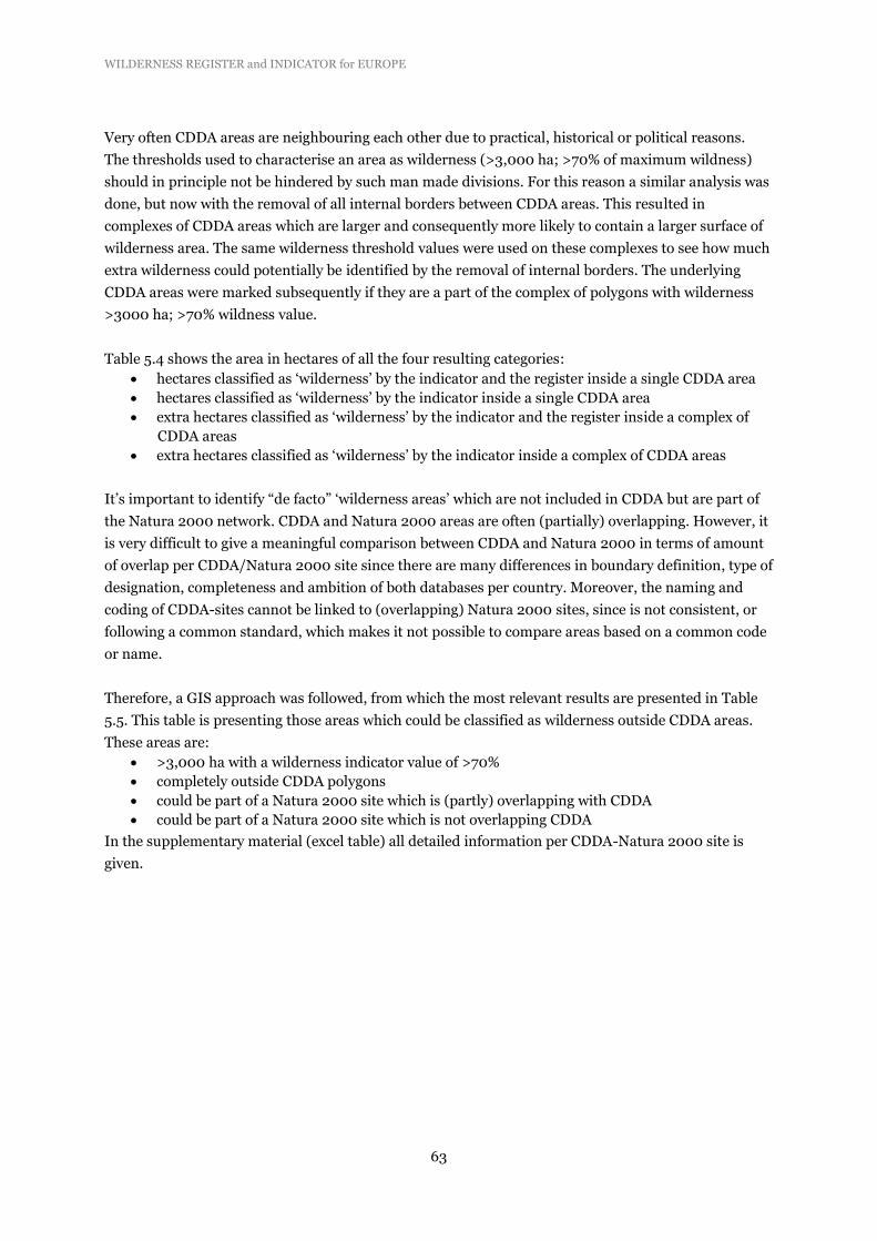
WILDERNESS REGISTER and INDICATOR for EUROPE
63
Very often CDDA areas are neighbouring each other due to practical, historical or political reasons.
The thresholds used to characterise an area as wilderness (>3,000 ha; >70% of maximum wildness)
should in principle not be hindered by such man made divisions. For this reason a similar analysis was
done, but now with the removal of all internal borders between CDDA areas. This resulted in
complexes of CDDA areas which are larger and consequently more likely to contain a larger surface of
wilderness area. The same wilderness threshold values were used on these complexes to see how much
extra wilderness could potentially be identified by the removal of internal borders. The underlying
CDDA areas were marked subsequently if they are a part of the complex of polygons with wilderness
>3000 ha; >70% wildness value.
Table 5.4 shows the area in hectares of all the four resulting categories:
hectares classified as ‘wilderness’ by the indicator and the register inside a single CDDA area
hectares classified as ‘wilderness’ by the indicator inside a single CDDA area
extra hectares classified as ‘wilderness’ by the indicator and the register inside a complex of
CDDA areas
extra hectares classified as ‘wilderness’ by the indicator inside a complex of CDDA areas
It’s important to identify “de facto” ‘wilderness areas’ which are not included in CDDA but are part of
the Natura 2000 network. CDDA and Natura 2000 areas are often (partially) overlapping. However, it
is very difficult to give a meaningful comparison between CDDA and Natura 2000 in terms of amount
of overlap per CDDA/Natura 2000 site since there are many differences in boundary definition, type of
designation, completeness and ambition of both databases per country. Moreover, the naming and
coding of CDDA-sites cannot be linked to (overlapping) Natura 2000 sites, since is not consistent, or
following a common standard, which makes it not possible to compare areas based on a common code
or name.
Therefore, a GIS approach was followed, from which the most relevant results are presented in Table
5.5. This table is presenting those areas which could be classified as wilderness outside CDDA areas.
These areas are:
>3,000 ha with a wilderness indicator value of >70%
completely outside CDDA polygons
could be part of a Natura 2000 site which is (partly) overlapping with CDDA
could be part of a Natura 2000 site which is not overlapping CDDA
In the supplementary material (excel table) all detailed information per CDDA-Natura 2000 site is
given.

WILDERNESS REGISTER and INDICATOR for EUROPE
64
Table 5.4 Likeliness of wilderness qualities in hectares of all the four resulting categories
Sum area
(ha) of
wilderness
Wilderness in CDDA Sites
(Areas >3,000ha; >70%
wildness)
Site
Wilderness
Total
Extra Wilderness in
complexes of adjacent
CDDA-Areas (>3,000ha;
>70% wildness)
Complex
Wilderness
Total
Grand Total
Country
code in Register
Not in
Register in Register
Not in
Register
ISL 3,640,513 71,123 3,711,636
715 715 3,712,351
SWE 3,111,770 91,498 3,203,268 6,091 10,683 16,774 32,20042
NOR 2,266,035 643,825 2,909,860 8,735 37,195 45,930 2,955,790
FIN 1,792,682
1,792,682 1,081 4,110 5,191 1,797,873
TUR 62,498 247,124 309,622 100 4,785 4,885 314,507
DEU 267,106
267,106 2,530 186 2,716 269,822
GBR
222,114 222,114
36,217 36,217 258,331
FRA
225,470 225,470
3,553 3,553 229,023
CHE 6,071 202,598 208,669
19,739 19,739 228,408
AUT 21,946 164,953 186,899 1,859 19,241 21,100 207,999
ROU 28,738 134,738 163,476 3,907 7,318 11,225 174,701
ITA 47,257 106,153 153,410 292 14,136 14,428 167,838
ESP 5,319 48,214 53,533
1,665 1,665 55,198
BGR 39,643
39,643 7,822 251 8,073 47,716
SVK 13,937 6,123 20,060 1,995 6,022 8,017 28,077
POL 20,026
20,026 1,948 3,935 5,883 25,909
SVN
11,248 11,248
4,720 4,720 15,968
SRB
14,696 14,696
14,696
EST
3,983 3,983 844 4,401 5,245 9,228
HRV
7,099 7,099 176
176 7,275
LVA
4,486 4,486
1,745 1,745 6,231
HUN
4,792 4,792
4,792
PRT 4,683
4,683
4,683
GRC
3,768 3,768 3,768
LTU
100 2,183 2,283 2,283
Grand Total 11,328,224 2,210,237 13,538,461 37,480 186,568 224,048 13,762,509
In % 82% 16% 98% 0.25% 1.35% 1.6% 100%
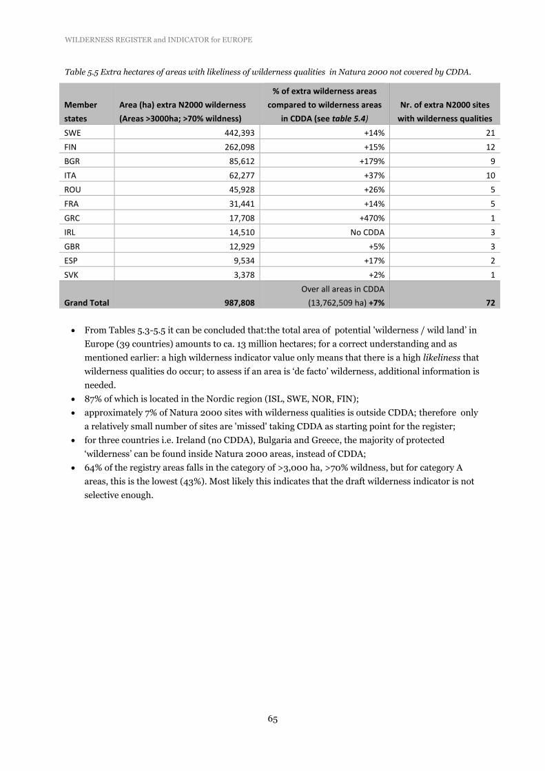
WILDERNESS REGISTER and INDICATOR for EUROPE
65
Table 5.5 Extra hectares of areas with likeliness of wilderness qualities in Natura 2000 not covered by CDDA.
Member
states
Area (ha) extra N2000 wilderness
(Areas >3000ha; >70% wildness)
% of extra wilderness areas
compared to wilderness areas
in CDDA (see table 5.4)
Nr. of extra N2000 sites
with wilderness qualities
SWE 442,393 +14% 21
FIN 262,098 +15% 12
BGR 85,612 +179% 9
ITA 62,277 +37% 10
ROU 45,928 +26% 5
FRA 31,441 +14% 5
GRC 17,708 +470% 1
IRL 14,510 No CDDA 3
GBR 12,929 +5% 3
ESP 9,534 +17% 2
SVK 3,378 +2% 1
Grand Total 987,808
Over all areas in CDDA
(13,762,509 ha) +7% 72
From Tables 5.3-5.5 it can be concluded that:the total area of potential 'wilderness / wild land’ in
Europe (39 countries) amounts to ca. 13 million hectares; for a correct understanding and as
mentioned earlier: a high wilderness indicator value only means that there is a high likeliness that
wilderness qualities do occur; to assess if an area is ‘de facto’ wilderness, additional information is
needed.
87% of which is located in the Nordic region (ISL, SWE, NOR, FIN);
approximately 7% of Natura 2000 sites with wilderness qualities is outside CDDA; therefore only
a relatively small number of sites are 'missed' taking CDDA as starting point for the register;
for three countries i.e. Ireland (no CDDA), Bulgaria and Greece, the majority of protected
‘wilderness’ can be found inside Natura 2000 areas, instead of CDDA;
64% of the registry areas falls in the category of >3,000 ha, >70% wildness, but for category A
areas, this is the lowest (43%). Most likely this indicates that the draft wilderness indicator is not
selective enough.

WILDERNESS REGISTER and INDICATOR for EUROPE
66
Figure 5.9 Protection status of the wildest cells (>70% wilderness value; >3000 ha cell clusters) by Natura 2000.

WILDERNESS REGISTER and INDICATOR for EUROPE
67
Figure 5.10 Protection status of the wildest cells (>70% wilderness value; >3000 ha cell clusters) by Natura
2000 combined with CDDA.
5.8.2 Comparison with existing regional mapping of wilderness
The relevance of regional mapping will be described and illustrated with examples from Scotland,
Austrian Alps, and the Carpathians (Romania), showing the impact of methodological issues such as
weighting different input layers, data processing and tackling problems of data inconsistencies.

WILDERNESS REGISTER and INDICATOR for EUROPE
68
Figures 5.11-5.13 show the visual comparison between the regional datasets and the proposed
European wilderness indicator.
Figure 5.11 Wilderness map for Scotland, (left side) compared with a cropped area of the European draft
wilderness indicator map (right side).
The Scottish Natural Heritage identified the most significant and valued areas of wild land sharing comparable
GIS techniques with the European indicator (http://www.snh.gov.uk/). The map of wild land is using four
physical attributes: perceived naturalness, rugged or challenging terrain, remoteness from public roads, and
visible lack of built development and other modern artifacts. In a later phase, this data was analysed to identify
the largest and most wild areas, and provisional boundaries of core-areas were drawn, (small map left) (SNH,
201365).
65 SNH, 2013. Mapping Scotland’s Wildness, Non –Technical Methodology, revised February 2013. Available at:
www.snh.gov.uk/docs/A892789.pdf
Cell resolution: 1km2 Method see text

WILDERNESS REGISTER and INDICATOR for EUROPE
69
Figure 5.12. National wilderness potential of Austria (Plutzar ,201066, left) with the draft wilderness indicator
map (right).
.
In this study large contiguous areas were identified where there are no roads and settlements, no hydro and ski lift
and no cable car facilities; furthermore also the natural degree of proximity of the forests was included in the
analysis. As visible, especially in the Alps, there are still significant wild areas that could be maintained or
developed as wilderness area (WWF 2012). The EU-wilderness indicator map (right) shows a highly comparable
pattern.
Figure 5.13 Wilderness rewilding alternative for the Southern Carpathians (University of Bucharest, Romania
as presented by Zika in 201267).with the draft wilderness indicator map (right).
66 Plutzar C. (2010). WWF Wildnis Vision – GIS-Modellierung, WWF Österreich-VINCA, interner Bericht, Wien. In: Kohler, B.
C. Laßnig, M. Zika, 2012. Wildnis in Österreich? Herausforderungen für Gesellschaft, Naturschutz und Naturraum-
management in Zeiten des Klimawandels. Österreichische Bundesforste AG (ÖBf AG) / WWF, Purkersdorf, Austria. 66 p. 67 Zika, M. 2012. Towards a National Strategy to promote wilderness. Nature Conservation Department , WWF Austria.
Wilderness Policy Conference, Brussels, 31 January 2012. Available at: http://es.slideshare.net/panparks/presentation-from-
michael-zika-wilderness-officer-wwf).

WILDERNESS REGISTER and INDICATOR for EUROPE
70
Figure 5.13 left and right shows a rather comparable pattern, but with less explicit core areas. This is most likely
due to the used FAO-grazing density map, which shows grazing activities in the proposed core areas (see Figure
5.3b).
The main features of the draft wilderness indicator when compared with the wilderness values on all
regional maps are very similar. The very high wilderness values found in the European map are also
visible in the all regional datasets (and generally vice versa). The European map is purely focusing on
wilderness areas, and thus excluding extreme areas which do not have any score on one of the sub
indicators. The Austrian map is narrowing down for wilderness areas in a comparable way. The
Scottish regional wildness map is looking more for a gradually increasing wildness value with the
majority of the region having values more than zero and anthropogenic areas included in the
classification. E.g. the SNH sub-indicator-map “Absence of Modern Artefacts” shows that there are
very few areas remaining with very high characteristics, i.e. the absence of any artefacts (SNH, 2012).
The final relative wildness mapping has been created by adding the various attribute strengths
together, this method can thus not take into consideration of how extremes in each the used attributes
may affect wildness. However, in several following phases the map is also narrowed down towards core
wilderness areas (SNH, 2013, see small map figure 5.9a). All regional datasets seem more accurate in
terms of resolution (European indicator = 1 km, e.g. Scotland uses a resolution of 25 m).
For a (statistical) GIS analysis only the Scottish dataset was made available. Table 5.6 shows the
comparison of all CDDA areas in Scotland for the draft wilderness indicator and the Scottish indicator
map. For consistency, the European threshold to define wilderness areas was used (see paragraph 5.4
and 5.5). The SNH uses a comparable methodology, but a slightly different scaling technique (SNH,
2013). When the proposed wilderness indicator method is applied on the Scottish map, it shows that
the majority of CDDA-areas are classified identically. Both indicators are based on completely different
spatial datasets, but they share the majority of used GIS techniques and physical attributes. It is not
surprising that the correlation between both indicators, when (simply) looking at the amount of wild
cells over all Scottish CDDA-areas, is more than 90%. Table 5.6 shows that also more than 90% of the
CDDA areas is identically classified and that just <3% of the sites (covering <10% of the total CDDA-
area) is classified differently.
Table 5.6 Comparison between proposed European wilderness indicator and the SNH-indicator in Scottish
CDDA areas.
Category
Nr. of Scottish
CDDA sites
Area of
Scottish
CDDA-sites
“Wilderness area” classified by both proposed European indicator- and
SNH-indicator 5.12% 55.19%
“No Wilderness area” classified by both proposed European indicator
and SNH-indicator 92.09% 35.25%
“Wilderness area” classified only by proposed wilderness indicator 0.93% 1.78%
“Wilderness area” classified only by SNH-indicator 1.86% 7.78%
Grand Total 100.00% 100.00%

WILDERNESS REGISTER and INDICATOR for EUROPE
71
5.9 Draft wilderness indicator: data improvement
We used the most relevant and best datasets available The most important problem issues such as
cross-border differences in mapped road densities, naturalness of vegetation cover and the scaling
effects were underpinned by worked-out examples. Nevertheless, at the European-wide scale datasets
used for compilation of a wilderness indicator, can be further improved.
To keep in mind the amount of effort to improve some datasets a review of the Scottish wildness map
provides a useful insight. The map was reviewed thoroughly by SNH trough a stakeholder approach
(SNH, 201268). One of the key remarks was “that the (SNH) GIS analysis provided a realistic picture
of the resource at the national level, but that its consideration at the local level required more
detailed assessment and judgment (SNH, 2012)”. So even with the best regional data available
performed with regional scale thresholds, still the local opinion of about an indicator will be difficult to
capture. Taking that in consideration, it seems appropriate to focus more on lacking datasets at the
EU-level (which are definitely available at regional level), than to put much effort in the slight
improvement of existing ones.
68 SNH, 2012. Analysis of response on phase I wildness mapping. 40 p. http://www.snh.gov.uk/docs/A869935.pdf

WILDERNESS REGISTER and INDICATOR for EUROPE
72
6 Achieved results
In this section the main achievements of the project are described and compared with the main
objectives and the tasks as formulated in the technical description of the contract. From the completed
tasks, the two main objectives of the project were achieved, i.e. a proposal for a wilderness indicator
based on a spatial analysis using a multi-criteria evaluation approach, and a registry for protected
wilderness areas in Europe.
(i) Working definition for wilderness
A working definition for wilderness was developed compatible with the IUCN guidelines on protected
area management class Ib ‘Wilderness’. Several additions and modifications were included to make it
applicable for filtering protected areas from the CDDA database (task v). Derived from the working
definition, a clear set of measurable criteria for the main features of wilderness was developed. These
criteria were used to evaluate if sites selected from the CDDA database qualified as wilderness.
Information was made available by local stakeholders or site managers. This working definition was
also used to select suitable datasets for developing a draft wilderness indicator (task iv).
(ii) Relevant datasets for the draft wilderness indicator
The most relevant datasets for setting up a wilderness indicator (task iv)were explored and selected.
Datasets to be used for the development of the indicator had to be consistent across national
boundaries throughout the European territory, with a sufficient and coherent spatial resolution (lowest
resolution for a EU coverage: 1 x 1 km). Selected were datasets on population density, landscape
fragmentation and infrastructure, and on naturalness of land cover and vegetation. These datasets
were combined for the compilation of a wilderness index, following a multi-criteria evaluation
approach (task iv). Most problematic was the availability of valuable data on naturalness of the
vegetation. European wide there is a lack of data, especially on naturalness of forests. However, by
combining land cover data (CORINE), with datasets on potential natural vegetation and on land use
intensity by livestock, a workable proxy for naturalness was compiled. The wilderness indicator might
be further improved in the future, if mapping data of pristine forests in Europe become available.
For compilation of a wilderness register (task v), the CDDA database was most useful, because it is the
only dataset covering 39 European countries which encompasses information on management
objectives. In certain cases the WDPA database provided some additional information, especially for
those protected areas not included in CDDA.
(iii) Stakeholder consultations to acquire relevant additional data and ensure quality of the data
Stakeholders in 39 countries (EEA members) were contacted to acquire relevant additional data
on pre-selected protected sites and to ensure sufficient quality of the data available. A list of ca. 700
pre-selected protected areas with potential wilderness qualities was checked by national stakeholders
for the quality of available data and additional information on attributes related to wilderness qualities
was provided. Additionally, about 100 site managers of protected wilderness and wild areas provided
information on attributes for those countries where no response was received from local stakeholders.
Valuable data was received from them, in addition to the information received from local stakeholders.
Based on these stakeholder and site managers consultations, information on wilderness qualities of
protected areas was received for 72% of the pre-selected PAs, thereby ensuring the quality of available
data for the main part of pre-selected PAs.

WILDERNESS REGISTER and INDICATOR for EUROPE
73
(iv) Produce a draft indicator for monitoring wilderness in Europe
The draft wilderness indicator will allow the quantitative assessment of trends in the extent of remote
land throughout Europe using GIS techniques. By periodically quantifying trends in land use and
development, this indicator will show changes in fragmentation rate, in remoteness from
infrastructure, and in other aspects related to wilderness qualities. It will reflect the impacts on the
natural environment from human activities such as settlement, transport, agriculture, and forestry. It
is based on spatial landscape features which make the presence of wilderness areas likely, and is built
upon four key-wilderness aspects derived from the wilderness working definition, i.e. naturalness of
land cover and vegetation, remoteness from settlements and remoteness from access, and terrain
ruggedness. Based on the datasets collected under task ii, a draft wilderness indicator was compiled
using a multi-criteria evaluation approach. The four sub-indicators were combined within a simple
weighted linear combination model. Several maps were delivered showing wilderness qualities
throughout the European continent (Fig.4.5), and their overlap with CDDA or the Natura 2000
network. The wilderness indicator was also applied to detect protected areas, not being registered in
CDDA, but potentially qualifying as wilderness area. These were either Natura 2000 areas not being
registered in CDDA, or non-protected areas, mainly occurring in Nordic regions.
Data handling is documented with arguments why certain datasets were either selected or rejected and
how datasets were processed.
(v) Produce a register of European wilderness building on CDDA
A draft registry for European wilderness was produced. Quality of the data was checked in a
verification process by National Focal Points. With the draft register, data availability on wilderness
areas is strongly improved for 39 countries (EEA members). More than 500 protected areas were
identified having wilderness qualities, of which 282 were qualified partly or total as wilderness
category A, i.e. meeting the criteria set for wilderness, with an estimated total coverage of 4-5% of the
Natura 2000 network. The register, however, cannot be considered complete yet, because for 16
countries no additional information was received yet from local stakeholders or from National Data
Managers for verification. Data processing for compiling the register is documented in detail.
(vi) Produce material for dissemination of the results
Two summary leaflets were compiled for the general public separately on the draft wilderness
indicator and the wilderness registry. Additionally, two power point presentations were prepared
targeting stakeholders separately on the wilderness indicator and register.
Threats and opportunities for European wilderness conservation
One of the ‘messages from Prague’ was “the compilation of a wilderness register, by identifying
in tandem with interested parties remaining areas of wilderness and wild lands, and their threats and
opportunities related to this’’. Within the current contract data availability on category A (wilderness)
and B (wild areas) protected areas was largely improved in cooperation with local NGOs, stakeholders,
site managers and National Data Managers. However, the elucidation of threats and opportunities
related to this is an important aspect of European wilderness conservation, which still has to be
analysed in close cooperation with site managers, local authorities and other relevant parties of the
remaining wilderness and wild areas in Europe. Based on this, priorities for further action can be

WILDERNESS REGISTER and INDICATOR for EUROPE
74
assessed for enhanced protection of wilderness and related biodiversity, which will contribute in
achieving the targets set out in the EU Biodiversity strategy to 2020 69.
69 http://ec.europa.eu/environment/nature/biodiversity/comm2006/2020.htm

WILDERNESS REGISTER and INDICATOR for EUROPE
75
7 Recommendations for future actions
7.1 Wilderness register: proposal on data management and updating
Tabular data: Several countries, such as Slovakia, Bulgaria and Czech Republic have IUCN
management categories Ia/Ib ‘embedded’ in other categories (mainly categories II and V). By
consequence, in statistics on protected areas there is ‘doubling’, leading to biased data on the amount
of hectares protected at national levels. We strongly recommend to remove this doubling from the
tabular part of the CDDA database.
Spatial data: The wilderness register holds tabular data of protected areas with wilderness quality. By
their unique CDDA code identifier these tabular data can be coupled to spatial data (site boundaries)
stored in CDDA. For most of these PAs, however, there is also spatial information of the wilderness
core zones (boundaries) within each area. These data can be made available with the help of NFPs or
site managers. This will further complete the wilderness register.
Wilderness category A/B (large wild areas in Nordic countries with high wilderness qualities, but
without core areas): further investigations are needed here. It should be possible to get local Sámi
people in Norway, Sweden and Finland, in cooperation with local agency representatives, willing to
define these areas themselves as part of an online participatory GIS survey (e.g. using the fuzzy online
GIS survey tool ‘MapMe’ developed by University of Leeds).
European territory: The wilderness register is built on the identification of wilderness areas in 39
European countries, i.e. EEA members and collaborating countries. Extension of the wilderness
register to neighbouring European countries such as Ukraine, Georgia, Belarus, Russia and Armenia is
recommended, as many (large) wilderness areas are located there. Data availability, however, might be
a serious problem and it should be explored if this extension of the territory of the register is feasible.
Update and hosting It is important that the status of all protected areas in the wilderness register is
monitored at a regular basis. Changes in protected area management should be monitored, as well as
changes in zonation. The register should be regularly updated, also taking into account ‘wild areas’
qualifying as ‘wilderness category B’ to be considered for inclusion in the register. The
method/workflow is dependent on the way data collation on protected areas is organised at the
national level, which is strongly different among countries. The National Data Focal Points (EIONET)
play a central role in this.
7.2 Wilderness indicator: proposal on data improvement
We used the most relevant and best datasets available nowadays. The most important problem issues
such as cross border differences in mapped road densities, naturalness of vegetation cover and the
scaling effects were underpinned by worked-out examples. Nevertheless, at the European-wide scale
datasets used for compilation of a wilderness indicator, can be further improved.

WILDERNESS REGISTER and INDICATOR for EUROPE
76
Dataset improvement is urgently needed on:
Road data: at the European level there is inconsistency in road data. For EU27 + Norway road
data are consistently available. However, for other European countries such as Albania,
Bosnia-Herzegovina, Croatia, Serbia, Macedonia and Turkey, the quality of road data is
significantly lower. This leads to concerns over trans-boundary differences in the quality of
road data and the effect that has on components of the wilderness indicator (e.g. sharp
changes of remoteness/accessibility at national borders as a result of changes in data quality.
The use of TeleAtlas will improve road data quality at a European-wide scale, but EEA has not
prolonged its user license for this database and could not be used under this contract.
Naturalness of vegetation: there are no European-wide databases available on vegetation
management and utilisation (e.g. timber harvesting, grazing, drainage, peat cutting). This
makes it rather difficult to correctly capture naturalness of vegetation based on land cover
data. By using the Land-use intensity database of FAO (spatial data on domestic animal
densities such as sheep, goats, cattle, pigs, buffalo and poultry), relevant information on
‘naturalness’ of open vegetation types was added. However, this was not the case for forest
cover. Until today, a database is lacking with spatial data on the occurrence of pristine forests
with non-intervention management. We strongly recommend that such a database is compiled
in the near future. This can greatly improve the wilderness quality indicator.
7.3 Public access
The consortium contracted for the development of the wilderness register (led by Alterra with
contributions of University of Leeds and PAN Parks Foundation) experienced a great interest from
various sectors (government, academic, NGO, site management) in the outputs of the register. Data on
wilderness areas throughout Europe were made available based on information provided by NGOs,
site managers and National Focal Points. We suggest making this output available on a public domain.
There is certain information enclosed in this report which seems to raise the interest of the civil society
and researchers:
- overlap between Europe’s protected wilderness areas and Natura 2000 network;
- the coverage of protected areas which are currently registered as wilderness in various existing
databases (CDDA/UNEP WCMC protected area database);
- the coverage of wilderness, which actually suit to the working definition of wilderness used in this
project (true wilderness note: category A);
- the coverage of wild areas which might qualify as wilderness in the future after certain management
measures have been taken (category B).
Each of these pieces of information should in our view be accessible per country and as an overall
figure for Europe (the participating 39 countries). Country specific information will support the
European Commission’s work on guaranteeing proper management and planning of Natura 2000 sites
and particularly to motivate protected area managers across the EEA members to take the right
measures to protect wilderness areas.
The public access to this information will help to contribute to the implementation of the Agenda for
Europe’s wilderness (also known as Message from Prague, EC Presidency Conference in Prague, May
2009) especially on:

WILDERNESS REGISTER and INDICATOR for EUROPE
77
a) generating a public debate about the state of art of wilderness protection in Europe
b) increasing the awareness about wilderness among the general public
c) defining the next steps towards a strategy to build a European Wilderness Preservation System
(Prague recommendations).
Eventually the register will likely lead to further research projects aiming to further refine our
knowledge on wilderness areas and wilderness attributes in Europe (for more details see Chapter 5).
Therefore, it is recommended that the information enclosed in this report, together with the
wilderness registry, will be made publicly available.

WILDERNESS REGISTER and INDICATOR for EUROPE
78

WILDERNESS REGISTER and INDICATOR for EUROPE
79
Glossary
ASCI Areas of Special Conservation Interest
BDC Biodiversity Data Centre
BISE Biodiversity Information System for Europe
CBD Convention on Biological Diversity
CDDA Common Database on Designated Areas
EEA European Environment Agency
EIONET European Environment Information and Observation Network
ESPON European Spatial Planning Observation Network
ETC-BD European Topic Centre on Biological Diversity
GIS Geographical Information System
INSPIRE Infrastructure for Spatial Information in Europe
NFP National Focal Point
NLEP Net Landscape Ecological Potential
IUCN International Union for Conservation of Nature
IUCN-WCPA World Commission on Designated Areas
pSCI proposed Site of Community Importance
SAC Special Area of Conservation
SCI Sites of Community Importance
SDF Standard Data Form
SEBI 2010 Streamlining European 2010 Biodiversity Indicators
SPA Special Protection Area
UNEP United Nations Environment Program
UNEP-WCMC World Conservation Monitoring Centre
WDPA World Database on Protected Areas

WILDERNESS REGISTER and INDICATOR for EUROPE
80

WILDERNESS REGISTER and INDICATOR for EUROPE
81
References
Beckmann, A. (2009). 'Protecting what's left of European wilderness', The Magazine of the Regional
Environmental Center GreenHorizon-online.com (http://www.greenhorizon-
online.com/index.php/Insight/protecting-whats-left-of-european-wilderness.html) accessed 15
November 2011.
Böhn, U., G. Gollub, C. Hettwer, Z. Neuhauslova, H. Schlueter & H. Weber (2000). Karte der
natürlichen Vegetation Europas. Map of the natural vegetation of Europe. Federal Agency for
Nature Conservation, Bonn.
Brus, D.J., G.M. Hengeveld, D.J.J. Walvoort, P.W. Goedhart, A.H. Heidema, G.J. Nabuurs & K. Gunia,
(2011). Statistical mapping of tree species over Europe. European Journal of Forest Research 131
(1): 145–157.
Carver, S., & S. Fritz (1999). Mapping remote areas using GIS. In M. Usher (Ed.), Landscape character:
Perspectives on management and change (pp. 112–126). Natural Heritage of Scotland Series,
HMSO: Edinburgh.
Carver, S., A. Evans & S. Fritz (2002). Wilderness Attribute Mapping in the United Kingdom.
International Journal of Wilderness 8: 24-29.
Carver, S., A. Comber, R. McMorran & S. Nutter (2012). A GIS model for mapping spatial patterns and
distribution of wild land in Scotland. Landscape and Urban Planning 104: 395– 409.
Comber, A., S. Carver, S. Fritz, R. McMorran, J. Washtell & P. Fisher (2010). Different methods,
different wilds: Evaluating alternative mappings of wildness using fuzzy MCE and Dempster-
Shafer MCE Computers. Environment and Urban Systems 34: 142–152.
Dudley, N. (Ed.) (2008). Guidelines for Applying Protected Area Management Categories. Gland,
Switzerland: IUCN. x + 86pp.
EEA (2006). Technical report No 9/2006. European forest types. Categories and types for sustainable
forest management reporting and policy. 2nd edition, May 2007.
EEA (2007). Technical report No 11/2007: Halting the loss of biodiversity by 2010: proposal for a first
set of indicators to monitor progress in Europe.
EEA (2010) Europe’s ecological backbone: recognising the true value of our mountains. EEA report no
6/2010, Copenhagen. 248 p.
EEA (2012). Streamlining European biodiversity indicators 2020: Building a future on lessons learnt
from the SEBI 2010 process. EEA Technical report No 11/2012. Copenhagen. 48 p.
EEA (2012). Protected areas in Europe –an overview. EEA Report No 05/2012. Copenhagen. 130 p.
Eupen, M. van, M.J. Metzger, M. Pérez-Soba, P.H. Verburg, A. van Doorn, A. & R.G.H. Bunce (2012).
A Rural Typology for Strategic European Policies. Land Use Policy 29: 473-482.
EUROPARC & IUCN (2000). Guidelines for Protected Area Management Categories. Interpretation
and Application of the Protected Area Management Categories in Europe. EUROPARC & WCPA,
Grafenau, Germany. 48 pp.
European Commission (2012). Guidance on the management of wilderness and wild areas in Natura
2000 (in press).
Fisher, M., S. Carver, Z. Kun, R. McMorran, K. Arrell & G. Mitchell (2010). Review of Status and
Conservation of Wild Land in Europe. Project commissioned by the Scottish Government.
IUCN/WCMC (1994). Guidelines for Protected Area Management Categories. Gland and Cambridge:
IUCN.

WILDERNESS REGISTER and INDICATOR for EUROPE
82
Jones-Walters, L. & K. Čivić (2010). Wilderness and biodiversity. Journal of Nature Conservation 18:
338-339.
Metzger, M.J., R.G.H. Bunce, M. van Eupen & M. Mirtl (2010). An assessment of long term ecosystem
research activities across European socio-ecological gradients. Journal of Environmental
Management 91: 1357-1365.
Sanderson, E.W., M. Jaiteh, M.A. Levy, K.H. Redford, A.V. Wannebo &G. Woolmer (2002). The
Human Footprint and the Last of the Wild. Bioscience 52: 891-904.

WILDERNESS REGISTER and INDICATOR for EUROPE
83
ANNEXES
Annex 1: IUCN management categories relevant for wilderness protection
Category Ia Strict nature reserve: protected area managed mainly for science
Strict nature reserves are strictly protected areas set aside to protect biodiversity and also possibly
geological/geomorphological features, where human visitation, use and impacts are strictly controlled
and limited to ensure protection of the conservation values. Such protected areas can serve as
indispensable reference areas for scientific research and monitoring.
Primary objective:
To conserve regionally, nationally or globally outstanding ecosystems, species (occurrences or
aggregations) and/ or geodiversity features: these attributes will have been formed mostly or
entirely by non-human forces and will be degraded or destroyed when subjected to all but very
light human impact.
Other objectives:
To preserve ecosystems, species and geodiversity features in a state as undisturbed by recent
human activity as possible;
To secure examples of the natural environment for scientific studies, environmental monitoring
and education, including baseline areas from which all avoidable access is excluded;
To minimize disturbance through careful planning and implementation of research and other
approved activities;
To conserve cultural and spiritual values associated with nature.
Distinguishing features:
Have a largely complete set of expected native species in ecologically significant densities or be
capable of returning them to such densities through natural processes or time-limited
interventions;
Have a full set of expected native ecosystems, largely intact with intact ecological processes, or
processes capable of being restored with minimal management intervention;
Be free of significant direct intervention by modern humans that would compromise the specified
conservation objectives for the area, which usually implies limiting access by people and
excluding settlement;
Not require substantial and on-going intervention to achieve its conservation objectives;
Be surrounded when feasible by land uses that contribute to the achievement of the area’s
specified conservation objectives;
Be suitable as a baseline monitoring site for monitoring the relative impact of human activities;
Be managed for relatively low visitation by humans;
Be capable of being managed to ensure minimal disturbance (especially relevant to marine
environments).

WILDERNESS REGISTER and INDICATOR for EUROPE
84
Strictly protected areas of category Ia are generally not large enough to ensure the integrity of their
ecosystems (most of them are smaller than 2,000 ha)70.
Distinction with other Categories:
Category Ib protected areas will generally be larger and less strictly protected from human visitation
than category Ia: although not usually subject to mass tourism they may be open to limited numbers of
people prepared for self-reliant travel such as on foot or by boat, which is not always the case in Ia.
Category VI protected areas contain natural areas where biodiversity conservation is linked with
sustainable use of natural resources, which is incompatible with category Ia. However, large category
VI protected areas may contain category Ia areas within their boundaries as part of management
zoning.
Category Ib: Wilderness area: protected area managed mainly for wilderness protection
Wilderness areas are protected areas usually large unmodified or slightly modified areas, retaining
their natural character and influence, without permanent or significant human habitation, which are
protected and managed so as to preserve their natural condition.
Primary objective:
To protect the long-term ecological integrity of natural areas that are undisturbed by significant
human activity, free of modern infrastructure and where natural forces and processes
predominate, so that current and future generations have the opportunity to experience such
areas.
Other objectives:
To provide for public access at levels and of a type which will maintain the wilderness qualities of
the area for present and future generations;
To enable indigenous communities to maintain their traditional wilderness-based lifestyle and
customs, living at low density and using the available resources in ways compatible with the
conservation objectives;
To protect the relevant cultural and spiritual values and non-material benefits to indigenous or
non-indigenous populations, such as solitude, respect for sacred sites, respect for ancestors etc.;
To allow for low-impact minimally invasive educational and scientific research activities, when
such activities cannot be conducted outside the wilderness area.
Distinguishing features:
Be free of modern infrastructure, development and industrial extractive activity, including but not
limited to roads, pipelines, power lines, cellphone towers, oil and gas platforms, offshore liquefied
natural gas terminals, other permanent structures, mining, hydropower development, oil and gas
extraction, agriculture including intensive livestock grazing, commercial fishing, low-flying
aircraft etc., preferably with highly restricted or no motorized access.
Be characterized by a high degree of intactness: containing a large percentage of the original
extent of the ecosystem, complete or near-complete native faunal and floral assemblages,
retaining intact predator-prey systems, and including large mammals.
70 http://data.iucn.org/dbtw-wpd/edocs/1999-048-2.pdf

WILDERNESS REGISTER and INDICATOR for EUROPE
85
Be of sufficient size to protect biodiversity; to maintain ecological processes and ecosystem
services; to maintain ecological refugia; to buffer against the impacts of climate change; and to
maintain evolutionary processes.
Offer outstanding opportunities for solitude, enjoyed once the area has been reached, by simple,
quiet and nonintrusive means of travel (i.e., non-motorized or highly regulated motorized access
where strictly necessary and consistent with the biological objectives listed above).
Be free of inappropriate or excessive human use or presence, which will decrease wilderness
values and ultimately prevent an area from meeting the biological and cultural criteria listed
above. However, human presence should not be the determining factor in deciding whether to
establish a category Ib area. The key objectives are biological intactness and the absence of
permanent infrastructure, extractive industries, agriculture, motorized use, and other indicators
of modern or lasting technology.
They can include somewhat disturbed areas that are capable of restoration to a wilderness state, and
smaller areas that might be expanded or could play an important role in a larger wilderness protection
strategy as part of a system of protected areas that includes wilderness, if the management objectives
for those somewhat disturbed or smaller areas are otherwise consistent with the objectives set out
above.
Within the European context, large wilderness areas are largely lacking outside parks of the Nordic
region. Category Ib areas can be found only in those parts of Europe which are scarcely suitable for any
type of utilisation and which thus remained uninhabited. Wilderness may include areas exploited for a
limited period in the past, without the natural diversity of habitats and species being significantly
altered, and which have been returned to natural succession71.
Distinction with other categories:
Category Ia protected areas are strictly protected areas, generally with only limited human visitation.
They are often (but not always) relatively small, in contrast to Ib. There would usually not be human
inhabitants in category Ia, but use by indigenous and local communities takes place in many Ib
protected areas.
Category II: Category Ib and II (National park) protected areas are often similar in size and in their
aim to protect functioning ecosystems. But whereas II usually includes (or plans to include) use by
visitors, including supporting infrastructure, in Ib visitor use is more limited and confined to those
with the skills and equipment to survive unaided.
Category VI is predicated on setting internal zoning and management regimes to support sustainable
use; although wilderness areas sometimes include limited traditional use by indigenous people this is
incidental to management aims rather than an intrinsic part of those aims.
Category II: National park: protected area managed mainly for ecosystem protection and
recreation
National parks are protected areas large natural or near natural areas set aside to protect large-scale
ecological processes, along with the complement of species and ecosystems characteristic of the area,
which also provide a foundation for environmentally and culturally compatible spiritual, scientific,
educational, recreational and visitor opportunities.
71 http://data.iucn.org/dbtw-wpd/edocs/1999-048-2.pdf
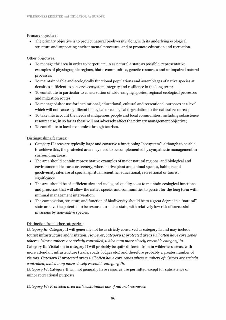
WILDERNESS REGISTER and INDICATOR for EUROPE
86
Primary objective:
The primary objective is to protect natural biodiversity along with its underlying ecological
structure and supporting environmental processes, and to promote education and recreation.
Other objectives:
To manage the area in order to perpetuate, in as natural a state as possible, representative
examples of physiographic regions, biotic communities, genetic resources and unimpaired natural
processes;
To maintain viable and ecologically functional populations and assemblages of native species at
densities sufficient to conserve ecosystem integrity and resilience in the long term;
To contribute in particular to conservation of wide-ranging species, regional ecological processes
and migration routes;
To manage visitor use for inspirational, educational, cultural and recreational purposes at a level
which will not cause significant biological or ecological degradation to the natural resources;
To take into account the needs of indigenous people and local communities, including subsistence
resource use, in so far as these will not adversely affect the primary management objective;
To contribute to local economies through tourism.
Distinguishing features:
Category II areas are typically large and conserve a functioning “ecosystem”, although to be able
to achieve this, the protected area may need to be complemented by sympathetic management in
surrounding areas.
The area should contain representative examples of major natural regions, and biological and
environmental features or scenery, where native plant and animal species, habitats and
geodiversity sites are of special spiritual, scientific, educational, recreational or tourist
significance.
The area should be of sufficient size and ecological quality so as to maintain ecological functions
and processes that will allow the native species and communities to persist for the long term with
minimal management intervention.
The composition, structure and function of biodiversity should be to a great degree in a “natural”
state or have the potential to be restored to such a state, with relatively low risk of successful
invasions by non-native species.
Distinction from other categories:
Category Ia: Category II will generally not be as strictly conserved as category Ia and may include
tourist infrastructure and visitation. However, category II protected areas will often have core zones
where visitor numbers are strictly controlled, which may more closely resemble category Ia.
Category Ib: Visitation in category II will probably be quite different from in wilderness areas, with
more attendant infrastructure (trails, roads, lodges etc.) and therefore probably a greater number of
visitors. Category II protected areas will often have core zones where numbers of visitors are strictly
controlled, which may more closely resemble category Ib.
Category VI: Category II will not generally have resource use permitted except for subsistence or
minor recreational purposes.
Category VI: Protected area with sustainable use of natural resources

WILDERNESS REGISTER and INDICATOR for EUROPE
87
Category VI protected areas conserve ecosystems and habitats, together with associated cultural values
and traditional natural resource management systems. They are generally large, with most of the
area in a natural condition, where a proportion is under sustainable natural resource management and
where low-level non-industrial use of natural resources compatible with nature conservation is seen as
one of the main aims of the area.
This is a relatively new category that was introduced by IUCN to cover predominantly natural areas
which “are managed to protect their biodiversity in such a way as to provide a sustainable flow of
products and services for the community”. The principal purpose of management is the sustainable use
of natural ecosystems. At least two-thirds of the area should be, and is planned to remain in its natural
state72.
Primary objective
To protect natural ecosystems and use natural resources sustainably, when conservation and
sustainable use can be mutually beneficial.
Other objectives:
To promote sustainable use of natural resources, considering ecological, economic and social
dimensions;
To promote social and economic benefits to local communities where relevant;
To facilitate inter-generational security for local communities’ livelihoods – therefore ensuring
that such livelihoods are sustainable;
To integrate other cultural approaches, belief systems and world-views within a range of social
and economic approaches to nature conservation;
To contribute to developing and/or maintaining a more balanced relationship between humans
and the rest of nature;
To contribute to sustainable development at national, regional and local level (in the last case
mainly to local communities and/or indigenous peoples depending on the protected natural
resources);
To facilitate scientific research and environmental monitoring, mainly related to the conservation
and sustainable use of natural resources;
To collaborate in the delivery of benefits to people, mostly local communities, living in or near to
the designated protected area;
To facilitate recreation and appropriate small-scale tourism
Distinguishing features:
Category VI protected areas, uniquely amongst the IUCN categories system, have the sustainable
use of natural resources as a means to achieve nature conservation, together and in synergy with
other actions more common to the other categories, such as protection.
Category VI protected areas aim to conserve ecosystems and habitats, together with associated
cultural values and natural resource management systems. Therefore, this category of protected
areas tends to be relatively large (although this is not obligatory).
The category is not designed to accommodate large-scale industrial harvest.
In general, IUCN recommends that a proportion of the area is retained in a natural condition,
which in some cases might imply its definition as a no-take management zone. Some countries
72 http://data.iucn.org/dbtw-wpd/edocs/1999-048-2.pdf

WILDERNESS REGISTER and INDICATOR for EUROPE
88
have set this as two-thirds; IUCN recommends that decisions need to be made at a national level
and sometimes even at the level of individual protected areas.
Distinction from other categories:
Category Ia: Category VI protected areas do conserve biodiversity, particularly at ecosystem and
landscape scale, but the aim would not be to protect them strictly from human interference. Although
scientific research may be important, it would be considered a priority only when applied to
sustainable uses of natural resources, either in order to improve them, or to understand how to
minimize the risks to ecological sustainability.
Category Ib: Category VI protected areas in certain cases could be considered close to “wilderness”,
however they explicitly promote sustainable use, unlike the situation in category Ib wilderness areas
where such use will be minimal and incidental to conservation aims. They also contribute to the
maintenance of environmental services, but not only by exclusive nature conservation, as the
sustainable use of natural resources can also contribute to the protection of ecosystems, large habitats,
and ecological processes.
Category II: Category VI protected areas aim to conserve ecosystems, as complete and functional as
possible, and their species and genetic diversity and associated environmental services, but differ from
category II in the role they play in the promotion of sustainable use of natural resources. Tourism can
be developed in category VI protected areas, but only as a very secondary activity or when they are part
of the local communities’ socioeconomic strategies (e.g., in relation to ecotourism development).
The areas in Europe to which it might apply most readily include some parts of Scandinavia, including
those inhabited by the Sámi people, and parts of marine environment73.
73 http://data.iucn.org/dbtw-wpd/edocs/1999-048-2.pdf

WILDERNESS REGISTER and INDICATOR for EUROPE
89
Annex 2: Stakeholders involved in the consultation process
Albania Protection and Preservation of Natural Environment in Albania
Austria WWF Austria
Belgium EEB member
Bosnia and Herzegovina WWF Mediterranean Programme Office
Bulgaria BBF
Croatia WWF Mediterranean Programme Office
Cyprus WWF Mediterranean Programme Office
Cyprus Terra Cypria
Czech Republic Hnuti Duha
Czech Republic Birdlife Czech Republic
Denmark Verdens Skove
Estonia Keskkonnaamet
Estonia Estonian Fund for Nature
Finland Metsahallitus
France WWF France
Germany Brandenburg Foundation
Germany WWF Germany
Great Britain John Muir Trust
Greece Hellenic Ornithological Society
Hungary WWF Hungary
Iceland INCA
Ireland Coillte
Italy Legambiente
Italy Federparchi
Kosovo WWF Mediterranean Programme Office
Latvia Baltic Environmental Fund
Liechtenstein
Lithuania Baltic Environmental Fund
Luxemburg Birdlife Luxemburg
Macedonia Bela Vista
Malta
Montenegro WWF Mediterranean Programme Office
Netherlands State Forestry
Norway Norwegian Directorate for Nature Management
Poland Naturalistic Foundation
Portugal EEB member
Portugal WWF Mediterranean Programme Office
Romania ProParks
Serbia WWF Medpo
Slovakia University of Matej Bel
Slovenia WWF Mediterranean Programme Office
Spain Europarc Spain

WILDERNESS REGISTER and INDICATOR for EUROPE
90
Sweden Naturskyddsföreningen
Sweden SEPA
Switzerland Pro Natura
Turkey WWF Turkey

WILDERNESS REGISTER and INDICATOR for EUROPE
91
Annex 3: NFPs and the verification process
Countries for which the wilderness qualification of PAs has been verified (73% of PAs on list of 522
PAs) (* = no PAs in wilderness register). Verification for 17 countries is pending.
Country Code Organisation Verification
Albania ALB *
Austria AUT Umweltbundesmamt Verified
Belgium BEL *
Bosnia-Herzegovina BIH Federal Ministry of Environment and Tourism Verified
Bulgaria BGR Pending
Croatia HRV Croation Environment Agency / State Institute for Nature Protection Verified
Cyprus CYP Pending
Czech Republic CZE Pending
Denmark DNK European Environment Information and Observation Network Verified
Estonia EST Pending
Finland FIN Metsahallitus Verified
France FRA Pending
Germany DEU Bundesamt für Naturschutz Verified
Greece GRC Pending
Hungary HUN *
Iceland ISL Pending
Ireland IRE National Parks and Wildlife Service, Dept of Arts, Heritage and the Gaeltacht Verified
Italy ITA Italian National Reference Centre on Nature and Biodiversity of EIONET Verified
Kosovo XKX Pending
Latvia LTV Nature Conservation Agency Verified
Liechtenstein LIE *
Lithuania LTU Pending
Luxembourg LUX Pending
Macedonia MKD Ministry of Environment and Physical Planning Verified
Malta MLT Pending
Montenegro MNE Environmental Protection Agency of Montenegro Verified
Netherlands NLD Ministry for Economic Affairs Verified
Norway NOR Directorate for Nature Management Verified
Poland POL Pending
Portugal PRT Instituto da Conservação da Natureza e das Florestas Verified
Romania ROU Pending
Serbia SRB Serbian Environmental Protection Agency Verified
Slovakia SVK State Nature Conservancy of the Slovak Republic Verified
Slovenia SVN Pending
Spain ESP Pending
Sweden SWE Swedish Environmental Protection Agency Verified
Switzerland CHE Federal Office for the Environment Verified
Turkey TUR Pending
United Kingdom GBR *

WILDERNESS REGISTER and INDICATOR for EUROPE
92
Annex 4: Detailed information on PAs in the wilderness register