Wilderness Inventory Unit: Monuments OR-034-069 Inventory Unit Index of Documents Monuments...
30
Wilderness Inventory Unit Index of Documents Monuments OR-034-069, 30 total pages Page 1: Index Cover Sheet Page 2: Form 1 – Documentation of BLM Wilderness Inventory: Findings on Record Page 5: Form 2 – Documentation of Current Wilderness Inventory Conditions Page 9: Form 2 – Summary of Findings and Conclusion Page 10: Wilderness Characteristics Overview – Monuments OR-034-069 Map 1 of 1 Page 11: Wilderness Characteristics – BLM Photo Points – Monuments Map & Log Page 12: OR-034-069 Monuments BLM Photos Page 15: H-6300-1-Wilderness Inventory Maintenance in BLM Oregon/Washington Appendix C – Road* Analysis: CNTY 514 Page 19: H-6300-1-Wilderness Inventory Maintenance in BLM Oregon/Washington Appendix C – Road* Analysis: CNTY 576 Page 23: H-6300-1-Wilderness Inventory Maintenance in BLM Oregon/Washington Appendix C – Road* Analysis: CNTY 3644 Page 27: H-6300-1-Wilderness Inventory Maintenance in BLM Oregon/Washington Appendix C – Road* Analysis: 7324-0-0A0 Prepared by: U.S. Department of the Interior Bureau of Land Management Vale District Office 100 Oregon Street Vale, Oregon 97918 Wilderness Inventory Unit Monuments OR-034-069 1 of 30
Transcript of Wilderness Inventory Unit: Monuments OR-034-069 Inventory Unit Index of Documents Monuments...
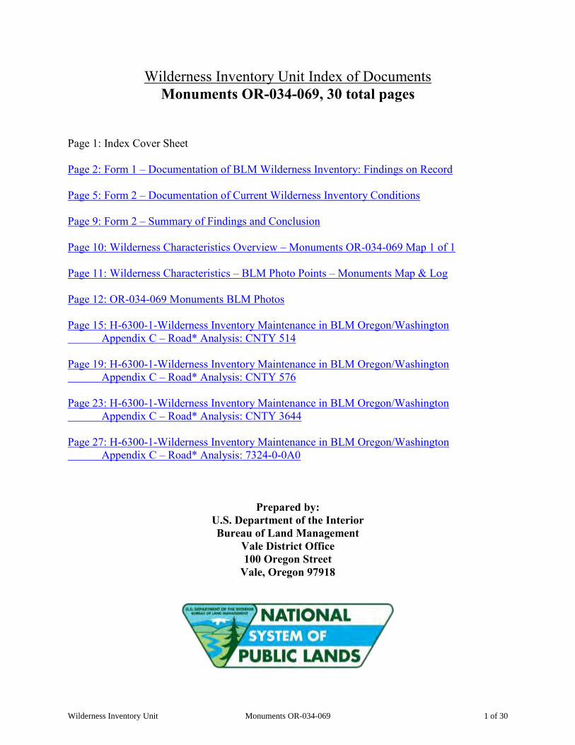
Wilderness Inventory Unit Index of Documents Monuments OR-034-069, 30 total pages
Page 1: Index Cover Sheet Page 2: Form 1 – Documentation of BLM Wilderness Inventory: Findings on Record Page 5: Form 2 – Documentation of Current Wilderness Inventory Conditions Page 9: Form 2 – Summary of Findings and Conclusion Page 10: Wilderness Characteristics Overview – Monuments OR-034-069 Map 1 of 1 Page 11: Wilderness Characteristics – BLM Photo Points – Monuments Map & Log Page 12: OR-034-069 Monuments BLM Photos Page 15: H-6300-1-Wilderness Inventory Maintenance in BLM Oregon/Washington Appendix C – Road* Analysis: CNTY 514 Page 19: H-6300-1-Wilderness Inventory Maintenance in BLM Oregon/Washington Appendix C – Road* Analysis: CNTY 576 Page 23: H-6300-1-Wilderness Inventory Maintenance in BLM Oregon/Washington Appendix C – Road* Analysis: CNTY 3644 Page 27: H-6300-1-Wilderness Inventory Maintenance in BLM Oregon/Washington Appendix C – Road* Analysis: 7324-0-0A0
Prepared by: U.S. Department of the Interior Bureau of Land Management
Vale District Office 100 Oregon Street
Vale, Oregon 97918
Wilderness Inventory Unit Monuments OR-034-069 1 of 30
Form 1 – Documentation of BLM Wilderness Inventory: Findings on Record 1 of 3
H-6300-1-WILDERNESS INVENTORY MAINTENANCE IN BLM OREGON/WASHINGTON
APPENDIX B – INVENTORY AREA EVALUATION
Evaluation of Current Conditions: 1) Document and review the existing BLM wilderness inventory findings on file, if available, regarding the presence or absence of individual wilderness characteristics, using Form 1, below. 2) Consider relevant information regarding current conditions available in the office to identify and describe any changes to the existing information (use interdisciplinary (ID) team knowledge, aerial photographs, field observations, maps, etc.), and document your findings on Form 2, below. When Citizen Information has been submitted regarding wilderness characteristics, document the submitted materials including: date of Submission; Name of District(s) and Field Office(s) Affected; Type of material Submitted (e.g. narrative, map, photo). Evaluate any submitted citizen information regarding the validity of proposed boundaries of the unit(s), the existence of roads and other boundary features, the size of the unit(s), and the presence or absence of wilderness characteristics based on relevant information available in the office (prior BLM inventories, ID team knowledge, aerial photographs, field observations, maps, etc.) Conduct field reviews as necessary to verify information and to ascertain current conditions. Reach conclusions on current conditions including boundaries, size of areas and presence or absence of wilderness characteristics. Fully explain the basis for each conclusion on form 2, including any critical differences between BLM and citizen information. Document your findings regarding current conditions for each inventoried area. Describe how the present conditions are similar to, or have changed from, the conditions documented in the original wilderness inventory. Document your findings on Form 2 for each inventory area. Cite to or attach data considered, including photographs, maps, GIS layers, field trip notes, project files, etc.
Wilderness Inventory Unit Monuments OR-034-069 2 of 30
Form 1 – Documentation of BLM Wilderness Inventory: Findings on Record 2 of 3
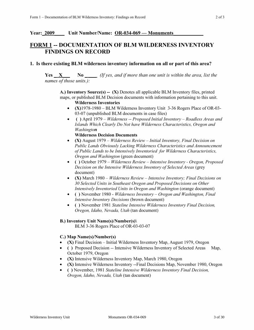
Year:_2009____ Unit Number/Name: OR-034-069 — Monuments____________
FORM 1 -- DOCUMENTATION OF BLM WILDERNESS INVENTORY FINDINGS ON RECORD
1. Is there existing BLM wilderness inventory information on all or part of this area?
Yes _ X___ No _ ___ (If yes, and if more than one unit is within the area, list the names of those units.):
A.) Inventory Source(s) -- (X) Denotes all applicable BLM Inventory files, printed maps, or published BLM Decision documents with information pertaining to this unit.
Wilderness Inventories (X)1978-1980 – BLM Wilderness Inventory Unit 3-36 Rogers Place of OR-03-
03-07 (unpublished BLM documents in case files) ( ) April 1979 – Wilderness -- Proposed Initial Inventory – Roadless Areas and
Islands Which Clearly Do Not have Wilderness Characteristics, Oregon and Washington Wilderness Decision Documents
(X) August 1979 – Wilderness Review – Initial Inventory, Final Decision on Public Lands Obviously Lacking Wilderness Characteristics and Announcement of Public Lands to be Intensively Inventoried for Wilderness Characteristics, Oregon and Washington (green document)
( ) October 1979 – Wilderness Review – Intensive Inventory - Oregon, Proposed Decision on the Intensive Wilderness Inventory of Selected Areas (grey document)
(X) March 1980 – Wilderness Review – Intensive Inventory; Final Decisions on 30 Selected Units in Southeast Oregon and Proposed Decisions on Other Intensively Inventoried Units in Oregon and Washington (orange document)
( ) November 1980 - Wilderness Inventory – Oregon and Washington, Final Intensive Inventory Decisions (brown document)
( ) November 1981 Stateline Intensive Wilderness Inventory Final Decision, Oregon, Idaho, Nevada, Utah (tan document)
B.) Inventory Unit Name(s)/Number(s)\ BLM 3-36 Rogers Place of OR-03-03-07 C.) Map Name(s)/Number(s) (X) Final Decision – Initial Wilderness Inventory Map, August 1979, Oregon ( ) Proposed Decision -- Intensive Wilderness Inventory of Selected Areas Map,
October 1979, Oregon (X) Intensive Wilderness Inventory Map, March 1980, Oregon (X) Intensive Wilderness Inventory --Final Decisions Map, November 1980, Oregon ( ) November, 1981 Stateline Intensive Wilderness Inventory Final Decision,
Oregon, Idaho, Nevada, Utah (tan document)
Wilderness Inventory Unit Monuments OR-034-069 3 of 30

Form 1 – Documentation of BLM Wilderness Inventory: Findings on Record 3 of 3
D.) BLM District(s)/Field Office(s) Vale District/Malheur Resource Area
2. BLM Inventory Findings on Record (Existing inventory information regarding wilderness characteristics (if more than one BLM inventory unit is associated with the area, list each unit and answer each question individually for each inventory unit): Inventory Source: See above.
Unit#/ Name
Size (historic acres)
Natural Condition? Y/N
Outstanding Solitude? Y/N
Outstanding Primitive & Unconfined Recreation? Y/N
Supplemental Values? Y/N
3-36 Rogers Place of OR-03-03-07
13,020 Y N N Y
TOTAL 13,020
Wilderness Inventory Unit Monuments OR-034-069 4 of 30

Form 2 – Documentation of Current Wilderness Inventory Conditions 1 of 4
H-6300-1-WILDERNESS INVENTORY MAINTENANCE IN BLM OREGON/WASHINGTON
APPENDIX B – INVENTORY AREA EVALUATION
Evaluation of Current Conditions: 1) Document and review the existing BLM wilderness inventory findings on file, if available, regarding the presence or absence of individual wilderness characteristics, using Form 1, below.
2) Consider relevant information regarding current conditions available in the office to identify and describe any changes to the existing information (use interdisciplinary (ID) team knowledge, aerial photographs, field observations, maps, etc.), and document your findings on Form 2, below. When Citizen Information has been submitted regarding wilderness characteristics, document the submitted materials including: date of Submission; Name of District(s) and Field Office(s) Affected; Type of material Submitted (e.g. narrative, map, photo). Evaluate any submitted citizen information regarding the validity of proposed boundaries of the unit(s), the existence of roads and other boundary features, the size of the unit(s), and the presence or absence of wilderness characteristics based on relevant information available in the office (prior BLM inventories, ID team knowledge, aerial photographs, field observations, maps, etc.) Conduct field reviews as necessary to verify information and to ascertain current conditions. Reach conclusions on current conditions including boundaries, size of areas and presence or absence of wilderness characteristics. Fully explain the basis for each conclusion on form 2, including any critical differences between BLM and citizen information. Document your findings regarding current conditions for each inventoried area. Describe how the present conditions are similar to, or have changed from, the conditions documented in the original wilderness inventory. Document your findings on Form 2 for each inventory area. Cite to or attach data considered, including photographs, maps, GIS layers, field trip notes, project files, etc.
Wilderness Inventory Unit Monuments OR-034-069 5 of 30
Form 2 – Documentation of Current Wilderness Inventory Conditions 2 of 4
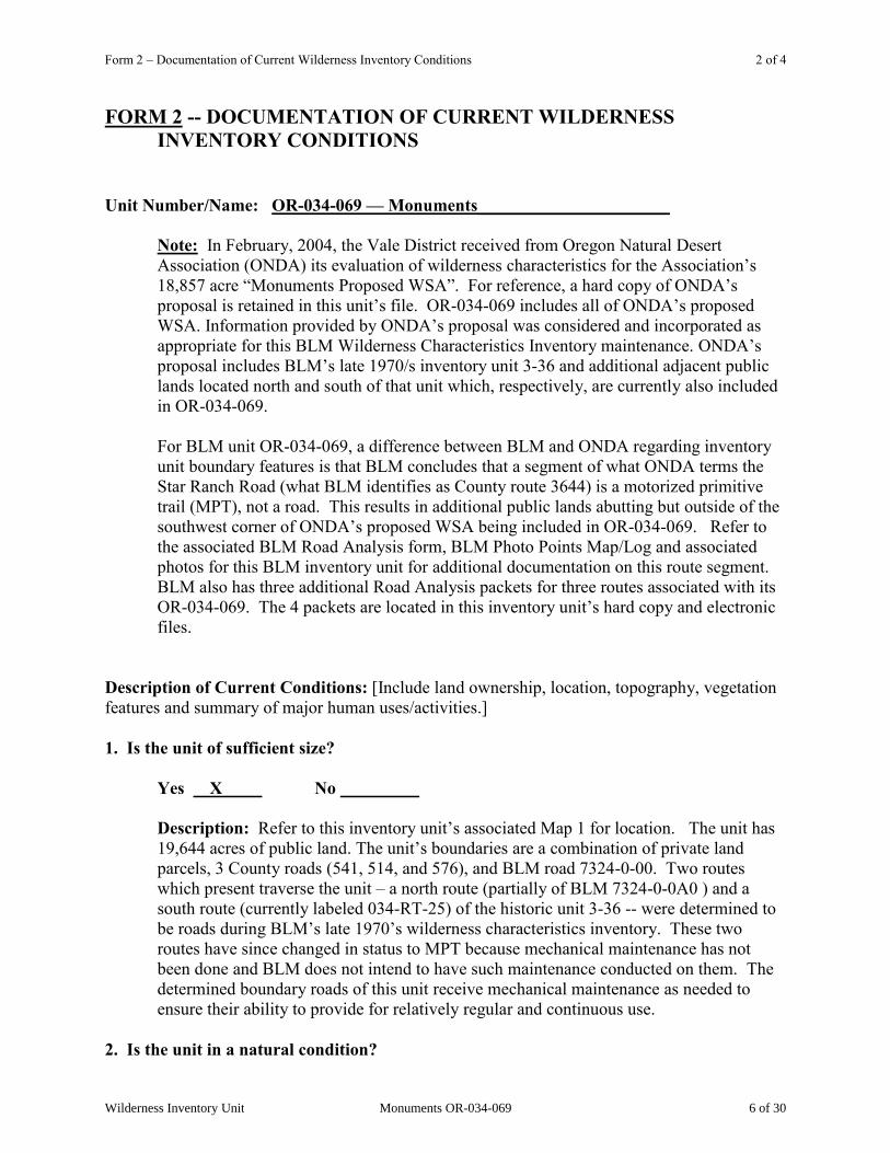
FORM 2 -- DOCUMENTATION OF CURRENT WILDERNESS INVENTORY CONDITIONS Unit Number/Name: OR-034-069 — Monuments______________________
Note: In February, 2004, the Vale District received from Oregon Natural Desert Association (ONDA) its evaluation of wilderness characteristics for the Association‟s
18,857 acre “Monuments Proposed WSA”. For reference, a hard copy of ONDA‟s proposal is retained in this unit‟s file. OR-034-069 includes all of ONDA‟s proposed WSA. Information provided by ONDA‟s proposal was considered and incorporated as appropriate for this BLM Wilderness Characteristics Inventory maintenance. ONDA‟s
proposal includes BLM‟s late 1970/s inventory unit 3-36 and additional adjacent public lands located north and south of that unit which, respectively, are currently also included in OR-034-069. For BLM unit OR-034-069, a difference between BLM and ONDA regarding inventory unit boundary features is that BLM concludes that a segment of what ONDA terms the Star Ranch Road (what BLM identifies as County route 3644) is a motorized primitive trail (MPT), not a road. This results in additional public lands abutting but outside of the southwest corner of ONDA‟s proposed WSA being included in OR-034-069. Refer to the associated BLM Road Analysis form, BLM Photo Points Map/Log and associated photos for this BLM inventory unit for additional documentation on this route segment. BLM also has three additional Road Analysis packets for three routes associated with its OR-034-069. The 4 packets are located in this inventory unit‟s hard copy and electronic files.
Description of Current Conditions: [Include land ownership, location, topography, vegetation features and summary of major human uses/activities.] 1. Is the unit of sufficient size? Yes X No
Description: Refer to this inventory unit‟s associated Map 1 for location. The unit has 19,644 acres of public land. The unit‟s boundaries are a combination of private land parcels, 3 County roads (541, 514, and 576), and BLM road 7324-0-00. Two routes which present traverse the unit – a north route (partially of BLM 7324-0-0A0 ) and a south route (currently labeled 034-RT-25) of the historic unit 3-36 -- were determined to be roads during BLM‟s late 1970‟s wilderness characteristics inventory. These two routes have since changed in status to MPT because mechanical maintenance has not been done and BLM does not intend to have such maintenance conducted on them. The determined boundary roads of this unit receive mechanical maintenance as needed to ensure their ability to provide for relatively regular and continuous use.
2. Is the unit in a natural condition?
Wilderness Inventory Unit Monuments OR-034-069 6 of 30
Form 2 – Documentation of Current Wilderness Inventory Conditions 3 of 4
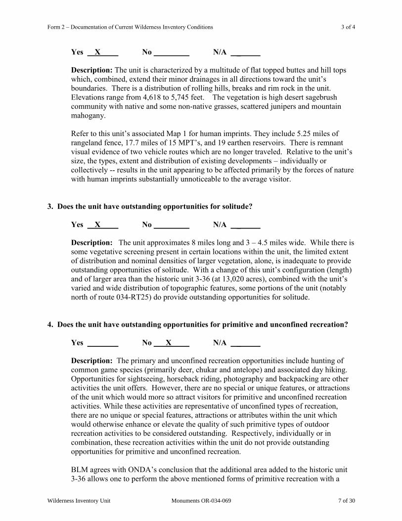
Yes X No N/A _
Description: The unit is characterized by a multitude of flat topped buttes and hill tops which, combined, extend their minor drainages in all directions toward the unit‟s
boundaries. There is a distribution of rolling hills, breaks and rim rock in the unit. Elevations range from 4,618 to 5,745 feet. The vegetation is high desert sagebrush community with native and some non-native grasses, scattered junipers and mountain mahogany. Refer to this unit‟s associated Map 1 for human imprints. They include 5.25 miles of rangeland fence, 17.7 miles of 15 MPT‟s, and 19 earthen reservoirs. There is remnant visual evidence of two vehicle routes which are no longer traveled. Relative to the unit‟s
size, the types, extent and distribution of existing developments – individually or collectively -- results in the unit appearing to be affected primarily by the forces of nature with human imprints substantially unnoticeable to the average visitor.
3. Does the unit have outstanding opportunities for solitude? Yes X No N/A _
Description: The unit approximates 8 miles long and 3 – 4.5 miles wide. While there is some vegetative screening present in certain locations within the unit, the limited extent of distribution and nominal densities of larger vegetation, alone, is inadequate to provide outstanding opportunities of solitude. With a change of this unit‟s configuration (length) and of larger area than the historic unit 3-36 (at 13,020 acres), combined with the unit‟s
varied and wide distribution of topographic features, some portions of the unit (notably north of route 034-RT25) do provide outstanding opportunities for solitude.
4. Does the unit have outstanding opportunities for primitive and unconfined recreation?
Yes No X N/A _
Description: The primary and unconfined recreation opportunities include hunting of common game species (primarily deer, chukar and antelope) and associated day hiking. Opportunities for sightseeing, horseback riding, photography and backpacking are other activities the unit offers. However, there are no special or unique features, or attractions of the unit which would more so attract visitors for primitive and unconfined recreation activities. While these activities are representative of unconfined types of recreation, there are no unique or special features, attractions or attributes within the unit which would otherwise enhance or elevate the quality of such primitive types of outdoor recreation activities to be considered outstanding. Respectively, individually or in combination, these recreation activities within the unit do not provide outstanding opportunities for primitive and unconfined recreation.
BLM agrees with ONDA‟s conclusion that the additional area added to the historic unit 3-36 allows one to perform the above mentioned forms of primitive recreation with a
Wilderness Inventory Unit Monuments OR-034-069 7 of 30

Form 2 – Documentation of Current Wilderness Inventory Conditions 4 of 4
sense of feeling unconfined. However, as BLM rationalized above, the activities do not – unlike what ONDA concludes -- reflect or exemplify outstanding opportunities for primitive recreation.
5. Does the unit have supplemental values?
Yes X No N/A _______ Description: One lek of Sage Grouse, a BLM special status animal species, has been documented within this unit. ONDA states is proposed Monuments WSA “may also be home to Mojave Black-collared Lizard, Desert Horned Lizard, Ground Snake, Ferruginous Hawk, Pygmy Rabbit, and White-tailed Antelope Squirrel,” which ONDA‟s February 2004 submission to the Vale District declares are listed as “sensitive species” by the State of Oregon. As of 2009, the Mohave Black-collard Lizard, Desert Horned Lizard, Ground Snake and the White-tailed Antelope Squirrel were not considered sensitive by Oregon Department of Fish and Wildlife, BLM, or U.S. Fish and Wildlife Service. BLM observation records confirm Ferruginous Hawks occur within this unit. BLM acknowledges that habitat requirements may exist for Mojave Black-collared Lizard, Desert Horned Lizard, Ground Snake, Pygmy Rabbit and White-tailed Antelope Squirrel; however, neither ONDA nor any other entity has provided BLM official documentation confirming these species are present within this inventory unit.
Wilderness Inventory Unit Monuments OR-034-069 8 of 30
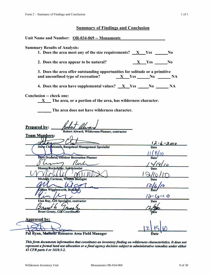
Form 2 – Summary of Findings and Conclusion 1 of 1
Summary of Findings and Conclusion
Unit Name and Number: OR-034-069 -- Monuments____________________ _ Summary Results of Analysis:
1. Does the area meet any of the size requirements? __X___Yes ______No 2. Does the area appear to be natural? __X___Yes ______No 3. Does the area offer outstanding opportunities for solitude or a primitive and unconfined type of recreation? __X___Yes ______No ______ NA
4. Does the area have supplemental values? __X __Yes _____No ______ NA
Conclusion -- check one: __X___ The area, or a portion of the area, has wilderness character. __ ____ The area does not have wilderness character.
Wilderness Inventory Unit Monuments OR-034-069 9 of 30
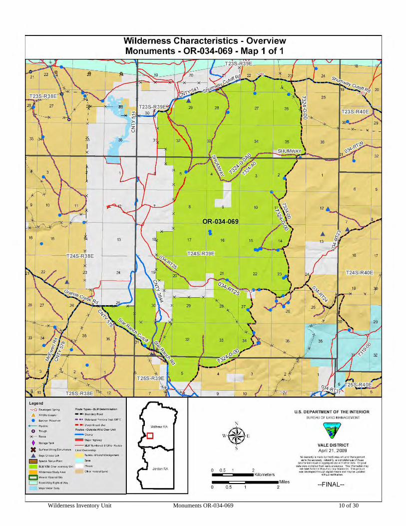
Wilderness Inventory Unit Monuments OR-034-069 10 of 30
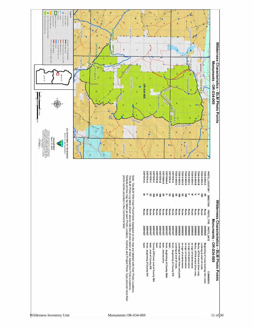
Wilderness Inventory Unit Monuments OR-034-069 11 of 30

Wilderness Inventory Unit Monuments OR-034-069 12 of 30
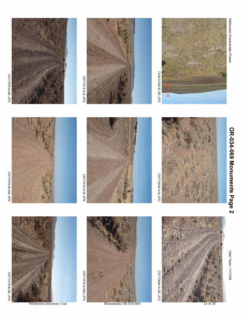
Wilderness Inventory Unit Monuments OR-034-069 13 of 30

Wilderness Inventory Unit Monuments OR-034-069 14 of 30
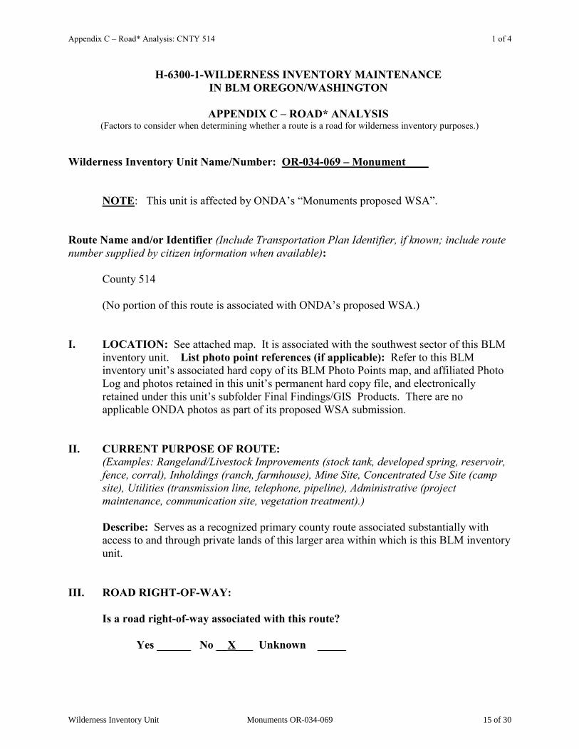
Appendix C – Road* Analysis: CNTY 514 1 of 4
H-6300-1-WILDERNESS INVENTORY MAINTENANCE IN BLM OREGON/WASHINGTON
APPENDIX C – ROAD* ANALYSIS
(Factors to consider when determining whether a route is a road for wilderness inventory purposes.)
Wilderness Inventory Unit Name/Number: OR-034-069 – Monument____
NOTE: This unit is affected by ONDA‟s “Monuments proposed WSA”. Route Name and/or Identifier (Include Transportation Plan Identifier, if known; include route number supplied by citizen information when available): County 514
(No portion of this route is associated with ONDA‟s proposed WSA.) I. LOCATION: See attached map. It is associated with the southwest sector of this BLM
inventory unit. List photo point references (if applicable): Refer to this BLM inventory unit‟s associated hard copy of its BLM Photo Points map, and affiliated Photo Log and photos retained in this unit‟s permanent hard copy file, and electronically retained under this unit‟s subfolder Final Findings/GIS Products. There are no applicable ONDA photos as part of its proposed WSA submission.
II. CURRENT PURPOSE OF ROUTE:
(Examples: Rangeland/Livestock Improvements (stock tank, developed spring, reservoir, fence, corral), Inholdings (ranch, farmhouse), Mine Site, Concentrated Use Site (camp site), Utilities (transmission line, telephone, pipeline), Administrative (project maintenance, communication site, vegetation treatment).)
Describe: Serves as a recognized primary county route associated substantially with access to and through private lands of this larger area within which is this BLM inventory unit.
III. ROAD RIGHT-OF-WAY:
Is a road right-of-way associated with this route? Yes ______ No __X___ Unknown _____
Wilderness Inventory Unit Monuments OR-034-069 15 of 30

Appendix C – Road* Analysis: CNTY 514 2 of 4
IV. CONSTRUCTION
Yes __X____ No _______
Examples: Paved __________ Bladed ___X_______ Graveled _____ Roadside Berms___X__ Cut/Fill _____ Other ______
Describe: Date of construction is unknown. Obvious berms along the route -- some are fresh (without vegetation on them), while others with varying extent of vegetation re-growth associated with them. Berms with thick and woody vegetation may more so be associated with initial construction of the route, while fresher berms may more so be a result of maintenance activities since the route‟s development.
V. IMPROVEMENTS
Yes ______ No ___X____
By Hand Tools _______ By Machine _____ Examples: Culverts _______ Stream Crossings ______ Bridges _______ Drainage ________ Barriers ________ Other ________
Describe: Not along the short segment of this route that is associated with this BLM inventory unit.
VI. MAINTENANCE:
A. Is there Evidence or Documentation of Maintenance using hand tools or machinery? Yes ____X____ No ________
If yes: Hand Tools (Y/N) _______ Machine (Y/N) __X_______
Explain: Obvious signs of blading and resultant berm located within the outer width of the route‟s disturbed surface area B. If the route is in good condition, but there is no evidence of maintenance, would mechanical maintenance with hand tools or machines be approved by BLM in the event this route became impassable?
Yes __X____ No ____
Comments: The route is in excellent condition, and there is evidence of recent blading. As a county primary access route, maintenance would continue to occur to provide for regular and continuous use over time.
Wilderness Inventory Unit Monuments OR-034-069 16 of 30
Appendix C – Road* Analysis: CNTY 514 3 of 4
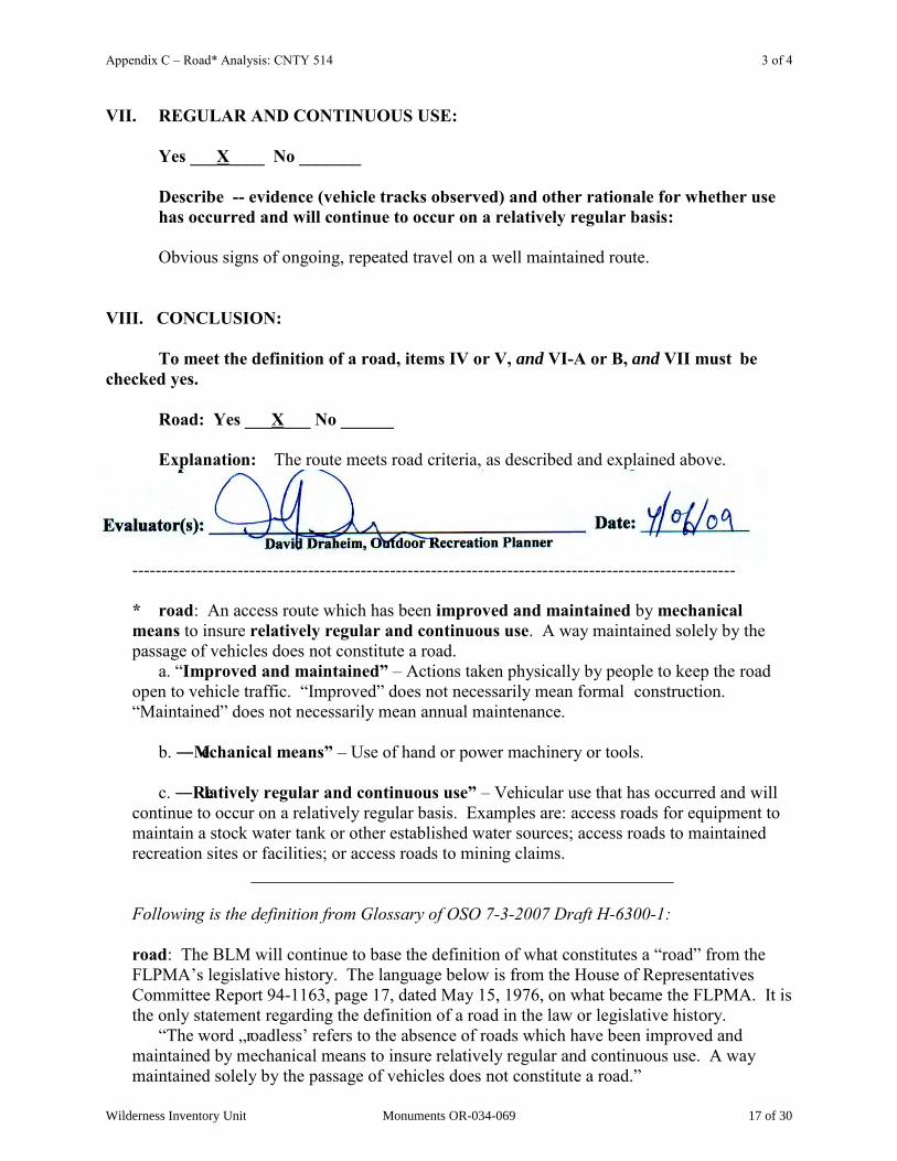
VII. REGULAR AND CONTINUOUS USE:
Yes ___X____ No _______
Describe -- evidence (vehicle tracks observed) and other rationale for whether use has occurred and will continue to occur on a relatively regular basis: Obvious signs of ongoing, repeated travel on a well maintained route.
VIII. CONCLUSION: To meet the definition of a road, items IV or V, and VI-A or B, and VII must be checked yes. Road: Yes ___X___ No ______ Explanation: The route meets road criteria, as described and explained above.
-------------------------------------------------------------------------------------------------------
* road: An access route which has been improved and maintained by mechanical means to insure relatively regular and continuous use. A way maintained solely by the passage of vehicles does not constitute a road. a. “Improved and maintained‖ – Actions taken physically by people to keep the road open to vehicle traffic. “Improved” does not necessarily mean formal construction. “Maintained” does not necessarily mean annual maintenance. b. ―Mechanical means‖ – Use of hand or power machinery or tools. c. ―Relatively regular and continuous use‖ – Vehicular use that has occurred and will continue to occur on a relatively regular basis. Examples are: access roads for equipment to maintain a stock water tank or other established water sources; access roads to maintained recreation sites or facilities; or access roads to mining claims.
________________________________________________ Following is the definition from Glossary of OSO 7-3-2007 Draft H-6300-1: road: The BLM will continue to base the definition of what constitutes a “road” from the FLPMA‟s legislative history. The language below is from the House of Representatives Committee Report 94-1163, page 17, dated May 15, 1976, on what became the FLPMA. It is the only statement regarding the definition of a road in the law or legislative history. “The word „roadless‟ refers to the absence of roads which have been improved and maintained by mechanical means to insure relatively regular and continuous use. A way maintained solely by the passage of vehicles does not constitute a road.”
Wilderness Inventory Unit Monuments OR-034-069 17 of 30
Appendix C – Road* Analysis: CNTY 514 4 of 4
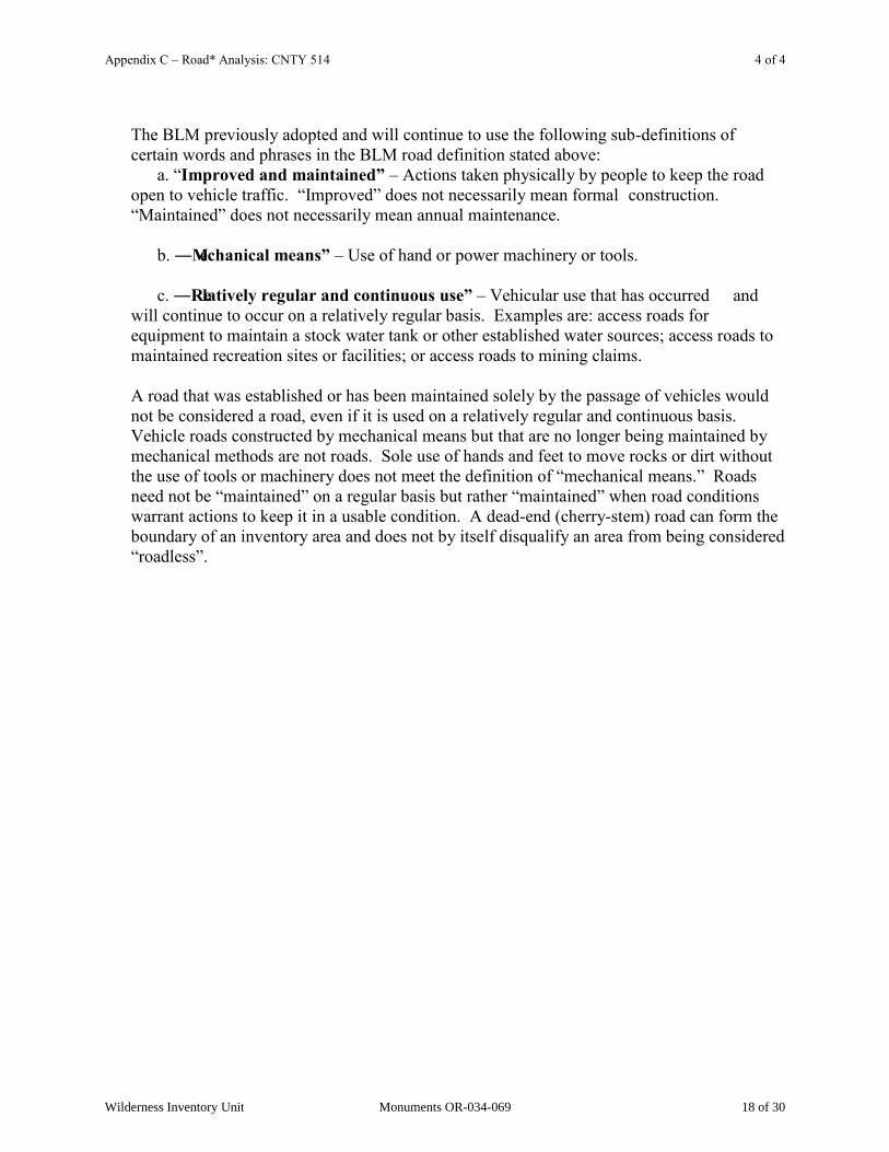
The BLM previously adopted and will continue to use the following sub-definitions of certain words and phrases in the BLM road definition stated above: a. “Improved and maintained‖ – Actions taken physically by people to keep the road open to vehicle traffic. “Improved” does not necessarily mean formal construction. “Maintained” does not necessarily mean annual maintenance. b. ―Mechanical means‖ – Use of hand or power machinery or tools. c. ―Relatively regular and continuous use‖ – Vehicular use that has occurred and will continue to occur on a relatively regular basis. Examples are: access roads for equipment to maintain a stock water tank or other established water sources; access roads to maintained recreation sites or facilities; or access roads to mining claims. A road that was established or has been maintained solely by the passage of vehicles would not be considered a road, even if it is used on a relatively regular and continuous basis. Vehicle roads constructed by mechanical means but that are no longer being maintained by mechanical methods are not roads. Sole use of hands and feet to move rocks or dirt without the use of tools or machinery does not meet the definition of “mechanical means.” Roads need not be “maintained” on a regular basis but rather “maintained” when road conditions warrant actions to keep it in a usable condition. A dead-end (cherry-stem) road can form the boundary of an inventory area and does not by itself disqualify an area from being considered “roadless”.
Wilderness Inventory Unit Monuments OR-034-069 18 of 30

Appendix C – Road* Analysis: CNTY 576 1 of 4
H-6300-1-WILDERNESS INVENTORY MAINTENANCE IN BLM OREGON/WASHINGTON
APPENDIX C – ROAD* ANALYSIS
(Factors to consider when determining whether a route is a road for wilderness inventory purposes.)
Wilderness Inventory Unit Name/Number: OR-034-069 – Monument____
NOTE: This unit is affected by ONDA‟s “Monuments proposed WSA”. Route Name and/or Identifier (Include Transportation Plan Identifier, if known; include route number supplied by citizen information when available): County 576
(The southern-most stretch is the only portion of this route segment affected by ONDA‟s
proposed WSA, of which ONDA identifies as a road. The remainder of this route segment is not affected by ONDA‟s proposed WSA.)
VIII. LOCATION: See attached map. It is a boundary route in this BLM inventory unit‟s
southwest corner. List photo point references (if applicable): Refer to this BLM inventory unit‟s associated hard copy of its BLM Photo Points map, and affiliated Photo Log and photos retained in this unit‟s permanent hard copy file, and electronically retained under this unit‟s subfolder Final Findings/GIS Products. There are no applicable ONDA photos depicting any of this route.
IX. CURRENT PURPOSE OF ROUTE:
(Examples: Rangeland/Livestock Improvements (stock tank, developed spring, reservoir, fence, corral), Inholdings (ranch, farmhouse), Mine Site, Concentrated Use Site (camp site), Utilities (transmission line, telephone, pipeline), Administrative (project maintenance, communication site, vegetation treatment).)
Describe: Serves as a recognized primary county route associated substantially with access to and through private lands of this larger area within which is this BLM inventory unit.
X. ROAD RIGHT-OF-WAY:
Is a road right-of-way associated with this route? Yes ______ No __X___ Unknown _____
Wilderness Inventory Unit Monuments OR-034-069 19 of 30
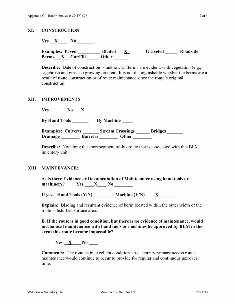
Appendix C – Road* Analysis: CNTY 576 2 of 4
XI. CONSTRUCTION
Yes __X____ No _______
Examples: Paved __________ Bladed ___X_______ Graveled _____ Roadside Berms___X__ Cut/Fill _____ Other ______
Describe: Date of construction is unknown. Berms are evident, with vegetation (e.g., sagebrush and grasses) growing on them. It is not distinguishable whether the berms are a result of route construction or of route maintenance since the route‟s original construction.
XII. IMPROVEMENTS
Yes ______ No ___X____
By Hand Tools _______ By Machine _____ Examples: Culverts _______ Stream Crossings ______ Bridges _______ Drainage ________ Barriers ________ Other ________
Describe: Not along the short segment of this route that is associated with this BLM inventory unit.
XIII. MAINTENANCE:
A. Is there Evidence or Documentation of Maintenance using hand tools or machinery? Yes ____X____ No ________
If yes: Hand Tools (Y/N) _______ Machine (Y/N) __X_______
Explain: Blading and resultant evidence of berm located within the outer width of the route‟s disturbed surface area. B. If the route is in good condition, but there is no evidence of maintenance, would mechanical maintenance with hand tools or machines be approved by BLM in the event this route became impassable?
Yes __X____ No ____
Comments: The route is in excellent condition. As a county primary access route, maintenance would continue to occur to provide for regular and continuous use over time.
Wilderness Inventory Unit Monuments OR-034-069 20 of 30

Appendix C – Road* Analysis: CNTY 576 3 of 4
XIV. REGULAR AND CONTINUOUS USE:
Yes ___X____ No _______
Describe -- evidence (vehicle tracks observed) and other rationale for whether use has occurred and will continue to occur on a relatively regular basis: Obvious signs of ongoing, repeated travel on a well maintained route.
VIII. CONCLUSION: To meet the definition of a road, items IV or V, and VI-A or B, and VII must be checked yes. Road: Yes ___X___ No ______ Explanation: The route meets road criteria, as described and explained above.
-------------------------------------------------------------------------------------------------------
* road: An access route which has been improved and maintained by mechanical means to insure relatively regular and continuous use. A way maintained solely by the passage of vehicles does not constitute a road. a. “Improved and maintained‖ – Actions taken physically by people to keep the road open to vehicle traffic. “Improved” does not necessarily mean formal construction. “Maintained” does not necessarily mean annual maintenance. b. ―Mechanical means‖ – Use of hand or power machinery or tools. c. ―Relatively regular and continuous use‖ – Vehicular use that has occurred and will continue to occur on a relatively regular basis. Examples are: access roads for equipment to maintain a stock water tank or other established water sources; access roads to maintained recreation sites or facilities; or access roads to mining claims.
________________________________________________ Following is the definition from Glossary of OSO 7-3-2007 Draft H-6300-1: road: The BLM will continue to base the definition of what constitutes a “road” from the FLPMA‟s legislative history. The language below is from the House of Representatives Committee Report 94-1163, page 17, dated May 15, 1976, on what became the FLPMA. It is the only statement regarding the definition of a road in the law or legislative history.
Wilderness Inventory Unit Monuments OR-034-069 21 of 30
Appendix C – Road* Analysis: CNTY 576 4 of 4
“The word „roadless‟ refers to the absence of roads which have been improved and maintained by mechanical means to insure relatively regular and continuous use. A way maintained solely by the passage of vehicles does not constitute a road.” The BLM previously adopted and will continue to use the following sub-definitions of certain words and phrases in the BLM road definition stated above: a. “Improved and maintained‖ – Actions taken physically by people to keep the road open to vehicle traffic. “Improved” does not necessarily mean formal construction. “Maintained” does not necessarily mean annual maintenance. b. ―Mechanical means‖ – Use of hand or power machinery or tools. c. ―Relatively regular and continuous use‖ – Vehicular use that has occurred and will continue to occur on a relatively regular basis. Examples are: access roads for equipment to maintain a stock water tank or other established water sources; access roads to maintained recreation sites or facilities; or access roads to mining claims. A road that was established or has been maintained solely by the passage of vehicles would not be considered a road, even if it is used on a relatively regular and continuous basis. Vehicle roads constructed by mechanical means but that are no longer being maintained by mechanical methods are not roads. Sole use of hands and feet to move rocks or dirt without the use of tools or machinery does not meet the definition of “mechanical means.” Roads need not be “maintained” on a regular basis but rather “maintained” when road conditions warrant actions to keep it in a usable condition. A dead-end (cherry-stem) road can form the boundary of an inventory area and does not by itself disqualify an area from being considered “roadless”.
Wilderness Inventory Unit Monuments OR-034-069 22 of 30
Appendix C – Road* Analysis: CNTY 3644 1 of 4
H-6300-1-WILDERNESS INVENTORY MAINTENANCE IN BLM OREGON/WASHINGTON
APPENDIX C – ROAD* ANALYSIS
(Factors to consider when determining whether a route is a road for wilderness inventory purposes.)
Wilderness Inventory Unit Name/Number: OR-034-069 – Monument____
NOTE: This unit is affected by ONDA‟s “Monuments proposed WSA”. Route Name and/or Identifier (Include Transportation Plan Identifier, if known; include route number supplied by citizen information when available): County 3644 -- its north-south segment branching north from County road 576
(It is what ONDA identifies as a portion of its “Star Ranch Rd.” , a route serving as the west boundary in the southwest corner area of ONDA‟s proposed WSA.)
XV. LOCATION: See attached map. It is associated with the southwest sector of this BLM
inventory unit. List photo point references (if applicable): Refer to this BLM inventory unit‟s associated hard copy of its BLM Photo Points map, and affiliated Photo Log and photos (specifically photo CNTY3644A-N[orth] )-- retained in this unit‟s
permanent hard copy file, and electronically retained under this unit‟s subfolder Final Findings/GIS Products. There are no applicable ONDA photos as part of its proposed WSA submission.
XVI. CURRENT PURPOSE OF ROUTE:
(Examples: Rangeland/Livestock Improvements (stock tank, developed spring, reservoir, fence, corral), Inholdings (ranch, farmhouse), Mine Site, Concentrated Use Site (camp site), Utilities (transmission line, telephone, pipeline), Administrative (project maintenance, communication site, vegetation treatment).)
Describe: There appears to be no current purpose of the route. At one time, it provided through access across public land between private land in section 30 and County road 576. This route segment across public lands is no longer needed, since alternate roads proximate to it provide the preferred access routes associated with this general corner area of this BLM inventory unit
XVII. ROAD RIGHT-OF-WAY:
Is a road right-of-way associated with this route? Yes ______ No __X___ Unknown _____
Wilderness Inventory Unit Monuments OR-034-069 23 of 30
Appendix C – Road* Analysis: CNTY 3644 2 of 4
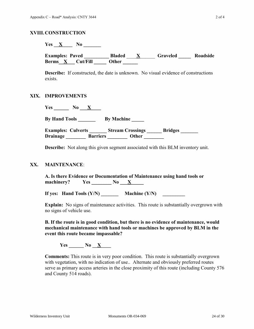
XVIII. CONSTRUCTION
Yes __X____ No _______
Examples: Paved __________ Bladed ____X______ Graveled _____ Roadside Berms__X___ Cut/Fill _____ Other ______
Describe: If constructed, the date is unknown. No visual evidence of constructions exists.
XIX. IMPROVEMENTS
Yes ______ No ___X____
By Hand Tools _______ By Machine _____ Examples: Culverts _______ Stream Crossings ______ Bridges _______ Drainage ________ Barriers ________ Other ________
Describe: Not along this given segment associated with this BLM inventory unit. XX. MAINTENANCE:
A. Is there Evidence or Documentation of Maintenance using hand tools or machinery? Yes ________ No ___X_____
If yes: Hand Tools (Y/N) _______ Machine (Y/N) _________
Explain: No signs of maintenance activities. This route is substantially overgrown with no signs of vehicle use. B. If the route is in good condition, but there is no evidence of maintenance, would mechanical maintenance with hand tools or machines be approved by BLM in the event this route became impassable?
Yes ______ No __X____
Comments: This route is in very poor condition. This route is substantially overgrown with vegetation, with no indication of use.. Alternate and obviously preferred routes serve as primary access arteries in the close proximity of this route (including County 576 and County 514 roads).
Wilderness Inventory Unit Monuments OR-034-069 24 of 30

Appendix C – Road* Analysis: CNTY 3644 3 of 4
XXI. REGULAR AND CONTINUOUS USE:
Yes _______ No ___X____
Describe -- evidence (vehicle tracks observed) and other rationale for whether use has occurred and will continue to occur on a relatively regular basis: There exists no evidence of use on this route. Within a few years, continued non-use will result in the route being identified by BLM as a discontinued (abandoned) route.
VIII. CONCLUSION: To meet the definition of a road, items IV or V, and VI-A or B, and VII must be checked yes. Road: Yes ______ No __X____
Explanation: The route does not meet road criteria, as described and explained, above. Presently, it barely represents a motorized primitive trail (and is not a road as ONDA identifies it).
-------------------------------------------------------------------------------------------------------
* road: An access route which has been improved and maintained by mechanical means to insure relatively regular and continuous use. A way maintained solely by the passage of vehicles does not constitute a road. a. “Improved and maintained‖ – Actions taken physically by people to keep the road open to vehicle traffic. “Improved” does not necessarily mean formal construction. “Maintained” does not necessarily mean annual maintenance. b. ―Mechanical means‖ – Use of hand or power machinery or tools. c. ―Relatively regular and continuous use‖ – Vehicular use that has occurred and will continue to occur on a relatively regular basis. Examples are: access roads for equipment to maintain a stock water tank or other established water sources; access roads to maintained recreation sites or facilities; or access roads to mining claims.
_______________________________________________ Following is the definition from Glossary of OSO 7-3-2007 Draft H-6300-1: road: The BLM will continue to base the definition of what constitutes a “road” from the FLPMA‟s legislative history. The language below is from the House of Representatives Committee Report 94-1163, page 17, dated May 15, 1976, on what became the FLPMA. It is the only statement regarding the definition of a road in the law or legislative history.
Wilderness Inventory Unit Monuments OR-034-069 25 of 30

Appendix C – Road* Analysis: CNTY 3644 4 of 4
“The word „roadless‟ refers to the absence of roads which have been improved and maintained by mechanical means to insure relatively regular and continuous use. A way maintained solely by the passage of vehicles does not constitute a road.” The BLM previously adopted and will continue to use the following sub-definitions of certain words and phrases in the BLM road definition stated above: a. “Improved and maintained‖ – Actions taken physically by people to keep the road open to vehicle traffic. “Improved” does not necessarily mean formal construction. “Maintained” does not necessarily mean annual maintenance. b. ―Mechanical means‖ – Use of hand or power machinery or tools. c. ―Relatively regular and continuous use‖ – Vehicular use that has occurred and will continue to occur on a relatively regular basis. Examples are: access roads for equipment to maintain a stock water tank or other established water sources; access roads to maintained recreation sites or facilities; or access roads to mining claims. A road that was established or has been maintained solely by the passage of vehicles would not be considered a road, even if it is used on a relatively regular and continuous basis. Vehicle roads constructed by mechanical means but that are no longer being maintained by mechanical methods are not roads. Sole use of hands and feet to move rocks or dirt without the use of tools or machinery does not meet the definition of “mechanical means.” Roads need not be “maintained” on a regular basis but rather “maintained” when road conditions warrant actions to keep it in a usable condition. A dead-end (cherry-stem) road can form the boundary of an inventory area and does not by itself disqualify an area from being considered “roadless”.
Wilderness Inventory Unit Monuments OR-034-069 26 of 30

Appendix C – Road* Analysis: 7324-0-0A0 1 of 4
H-6300-1-WILDERNESS INVENTORY MAINTENANCE IN BLM OREGON/WASHINGTON
APPENDIX C – ROAD* ANALYSIS
(Factors to consider when determining whether a route is a road for wilderness inventory purposes.)
Wilderness Inventory Unit Name/Number: OR-034-069 – Monument____
NOTE: This unit is affected by ONDA‟s “Monuments proposed WSA”. Route Name and/or Identifier (Include Transportation Plan Identifier, if known; include route number supplied by citizen information when available): 7324-0-0A0
(It is ONDA‟s combination of its MN2a [described as a vehicular “way” -- i.e., motorized primitive trail], MN3b [described as an “unk” -- for which ONDA does not provide a descriptive], and MN8f [described as a vehicular “way”]. This combined linear route crosses public lands of its proposed WSA.)
XXII. LOCATION: See attached map. It is associated with the northern portion of this BLM
inventory unit. List photo point references (if applicable): Refer to this BLM inventory unit‟s associated hard copy of its BLM Photo Points map, and affiliated Photo Log and photos -- retained in this unit‟s permanent hard copy file, and electronically retained under this unit‟s subfolder Final Findings/GIS Products. Any applicable ONDA photos and affiliated Photo Log are electronically retained under /S/Wilderness Characteristics/Citizen Proposals.
XXIII. CURRENT PURPOSE OF ROUTE:
(Examples: Rangeland/Livestock Improvements (stock tank, developed spring, reservoir, fence, corral), Inholdings (ranch, farmhouse), Mine Site, Concentrated Use Site (camp site), Utilities (transmission line, telephone, pipeline), Administrative (project maintenance, communication site, vegetation treatment).)
Describe: Avails access to 2 earthen reservoirs. It may be used by hunters of common game species of the area.
XXIV. ROAD RIGHT-OF-WAY:
Is a road right-of-way associated with this route? Yes ______ No __X___ Unknown _____
Wilderness Inventory Unit Monuments OR-034-069 27 of 30
Appendix C – Road* Analysis: 7324-0-0A0 2 of 4
XXV. CONSTRUCTION
Yes ______ No ___X____
Examples: Paved __________ Bladed __________ Graveled _____ Roadside Berms_____ Cut/Fill _____ Other __X____
Describe: If constructed, presently there is no visual evidence of the activity. The route may have been established when one or both reservoirs were developed.
XXVI. IMPROVEMENTS
Yes ______ No ___X____
By Hand Tools _______ By Machine _____ Examples: Culverts _______ Stream Crossings ______ Bridges _______ Drainage ________ Barriers ________ Other ________
Describe: XXVII. MAINTENANCE:
A. Is there Evidence or Documentation of Maintenance using hand tools or machinery? Yes ________ No ___X_____
If yes: Hand Tools (Y/N) _______ Machine (Y/N) _________
Explain: No evidence observed. B. If the route is in good condition, but there is no evidence of maintenance, would mechanical maintenance with hand tools or machines be approved by BLM in the event this route became impassable?
Yes ______ No __X____
Comments: The route is not in good condition; rather, it is in poor condition. Although passable by a four-wheel drive vehicle (e.g., standard sized pickup truck or an all-terrain vehicle) -- due to the substantially near-flat terrain and nature of the natural materials on its travel surface -- the extent of vegetation encroachment at the route‟s outer edge of travel surface and in its median indicates no maintenance has occurred. Given the nature of the terrain it traverses, in the event of required maintenance of the earthen reservoirs, the route would not need mechanical maintenance actions to provide access for the heavy equipment performing the task.
Wilderness Inventory Unit Monuments OR-034-069 28 of 30
Appendix C – Road* Analysis: 7324-0-0A0 3 of 4
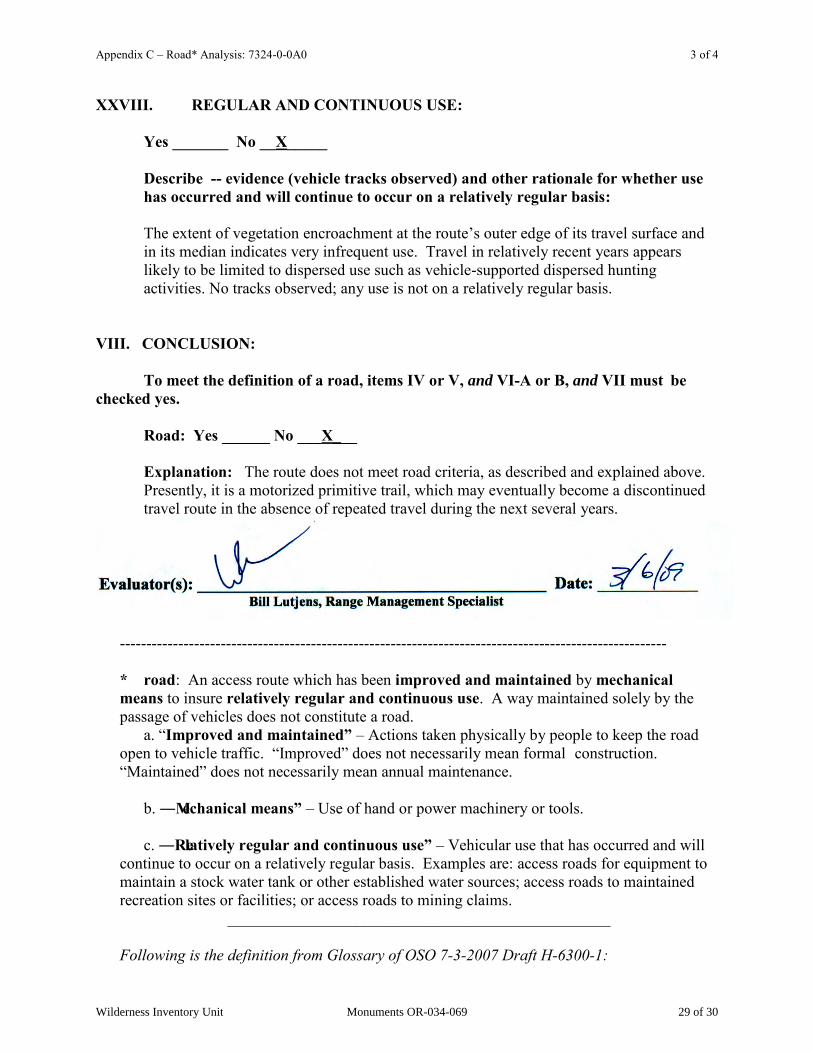
XXVIII. REGULAR AND CONTINUOUS USE:
Yes _______ No __X_____
Describe -- evidence (vehicle tracks observed) and other rationale for whether use has occurred and will continue to occur on a relatively regular basis: The extent of vegetation encroachment at the route‟s outer edge of its travel surface and in its median indicates very infrequent use. Travel in relatively recent years appears likely to be limited to dispersed use such as vehicle-supported dispersed hunting activities. No tracks observed; any use is not on a relatively regular basis.
VIII. CONCLUSION: To meet the definition of a road, items IV or V, and VI-A or B, and VII must be checked yes. Road: Yes ______ No ___X___
Explanation: The route does not meet road criteria, as described and explained above. Presently, it is a motorized primitive trail, which may eventually become a discontinued travel route in the absence of repeated travel during the next several years.
-------------------------------------------------------------------------------------------------------
* road: An access route which has been improved and maintained by mechanical means to insure relatively regular and continuous use. A way maintained solely by the passage of vehicles does not constitute a road. a. “Improved and maintained‖ – Actions taken physically by people to keep the road open to vehicle traffic. “Improved” does not necessarily mean formal construction. “Maintained” does not necessarily mean annual maintenance. b. ―Mechanical means‖ – Use of hand or power machinery or tools. c. ―Relatively regular and continuous use‖ – Vehicular use that has occurred and will continue to occur on a relatively regular basis. Examples are: access roads for equipment to maintain a stock water tank or other established water sources; access roads to maintained recreation sites or facilities; or access roads to mining claims.
________________________________________________ Following is the definition from Glossary of OSO 7-3-2007 Draft H-6300-1:
Wilderness Inventory Unit Monuments OR-034-069 29 of 30
Appendix C – Road* Analysis: 7324-0-0A0 4 of 4
road: The BLM will continue to base the definition of what constitutes a “road” from the FLPMA‟s legislative history. The language below is from the House of Representatives Committee Report 94-1163, page 17, dated May 15, 1976, on what became the FLPMA. It is the only statement regarding the definition of a road in the law or legislative history. “The word „roadless‟ refers to the absence of roads which have been improved and maintained by mechanical means to insure relatively regular and continuous use. A way maintained solely by the passage of vehicles does not constitute a road.” The BLM previously adopted and will continue to use the following sub-definitions of certain words and phrases in the BLM road definition stated above: a. “Improved and maintained‖ – Actions taken physically by people to keep the road open to vehicle traffic. “Improved” does not necessarily mean formal construction. “Maintained” does not necessarily mean annual maintenance. b. ―Mechanical means‖ – Use of hand or power machinery or tools. c. ―Relatively regular and continuous use‖ – Vehicular use that has occurred and will continue to occur on a relatively regular basis. Examples are: access roads for equipment to maintain a stock water tank or other established water sources; access roads to maintained recreation sites or facilities; or access roads to mining claims. A road that was established or has been maintained solely by the passage of vehicles would not be considered a road, even if it is used on a relatively regular and continuous basis. Vehicle roads constructed by mechanical means but that are no longer being maintained by mechanical methods are not roads. Sole use of hands and feet to move rocks or dirt without the use of tools or machinery does not meet the definition of “mechanical means.” Roads need not be “maintained” on a regular basis but rather “maintained” when road conditions warrant actions to keep it in a usable condition. A dead-end (cherry-stem) road can form the boundary of an inventory area and does not by itself disqualify an area from being considered “roadless”.
Wilderness Inventory Unit Monuments OR-034-069 30 of 30