Grasslands Savanna (Tropical Grassland) and Prairie (Temperate Grassland)
date post
20-Dec-2015Category
view
223download
0
Why is one area of the earth’s land surface a desert, another a grassland, and another a forest?

Climate- long term weather patterns
Weather- momentary conditions of the atmosphere; created by the unequal heating & cooling of the earth’s surface.
I. Climate
Temperature & Precipitation- major factors that determine an areas climate.
Humidity- the amount of water vapor air holds, which is dependent upon temperature.
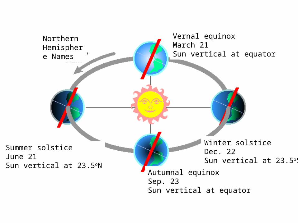
Winter solsticeDec. 22Sun vertical at 23.5oS
Winter solsticeDec. 22Sun vertical at 23.5oS
Autumnal equinoxSep. 23Sun vertical at equator
Summer solsticeJune 21Sun vertical at 23.5oN
Vernal equinoxMarch 21Sun vertical at equator
Northern Hemisphere Names

Earth further from sun
Earth closer to sun
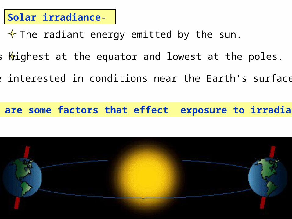
Solar irradiance-
What are some factors that effect exposure to irradiance?
The radiant energy emitted by the sun.
It is highest at the equator and lowest at the poles.
We are interested in conditions near the Earth’s surface

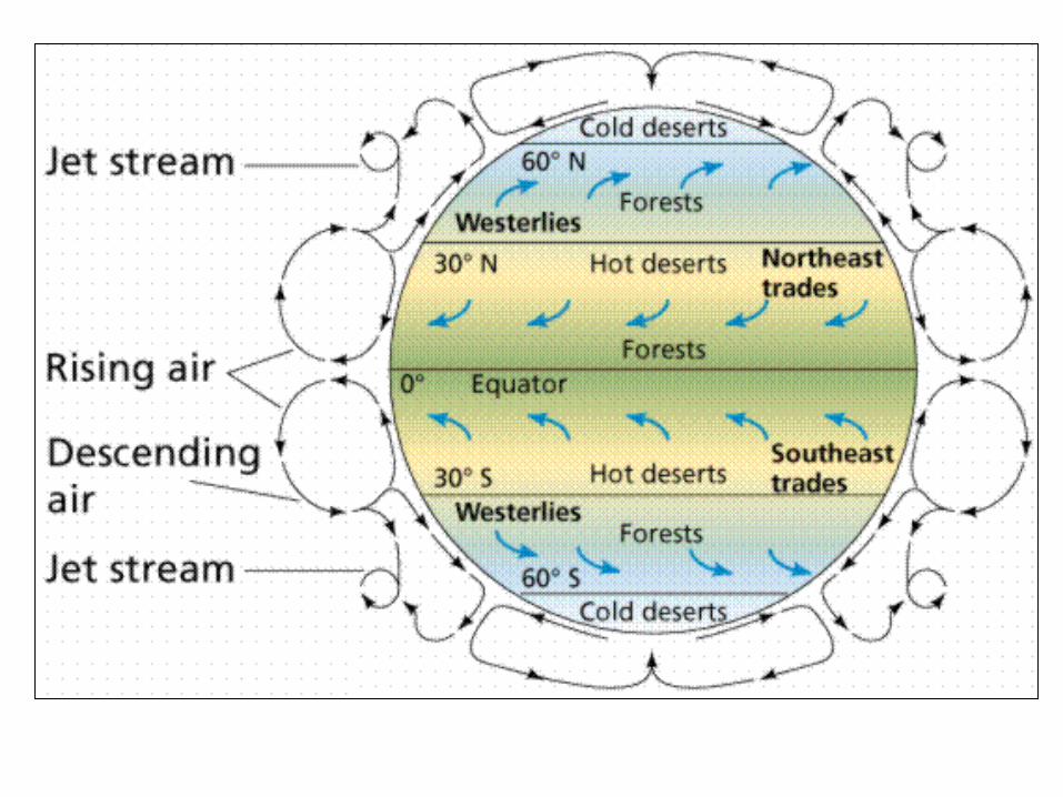
Convection cell model
Non-rotating Earth

Add rotation and add landmasses unequal heating and cooling of the Earth
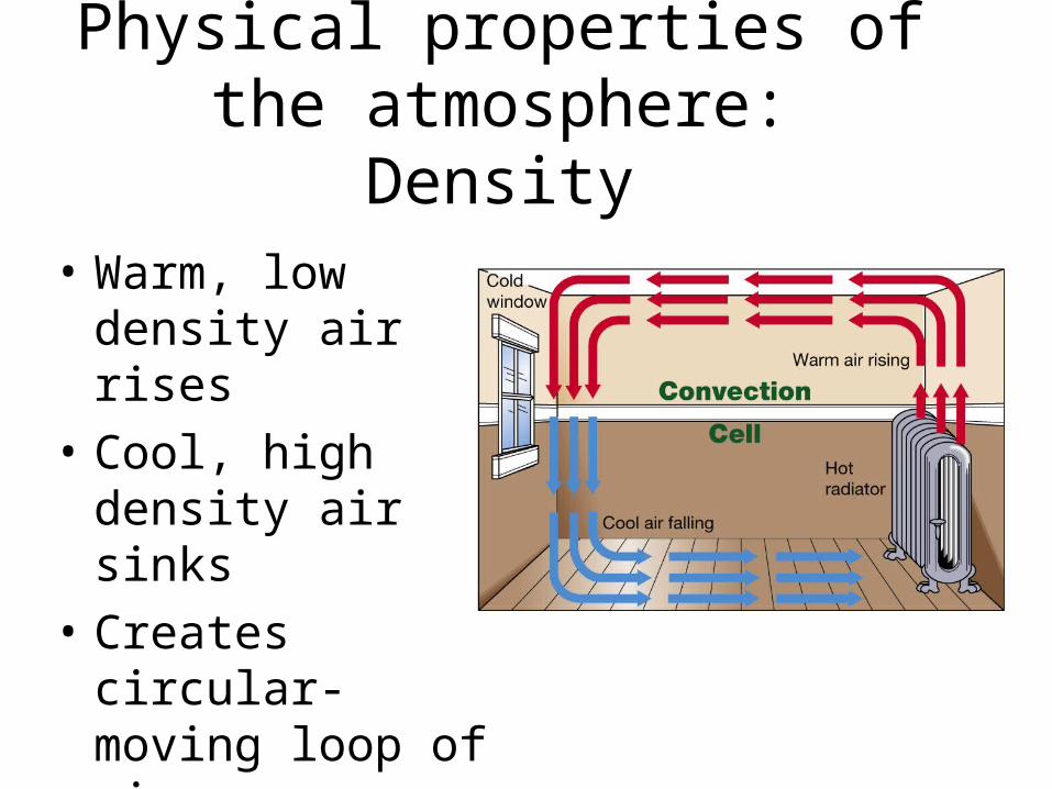
Physical properties of the atmosphere: Density
• Warm, low density air rises
• Cool, high density air sinks
• Creates circular- moving loop of air (convection cell)

Physical properties of the atmosphere: Water vapor
• Cool air cannot hold much water vapor, so is typically dry
• Warm air can hold more water vapor, so is typically moist
• Water vapor decreases the density of air

Physical properties of the atmosphere: Pressure
• A column of cool, dense air causes high pressure at the surface, which will lead to sinking air
• A column of warm, less dense air causes low pressure at the surface, which will lead to rising air
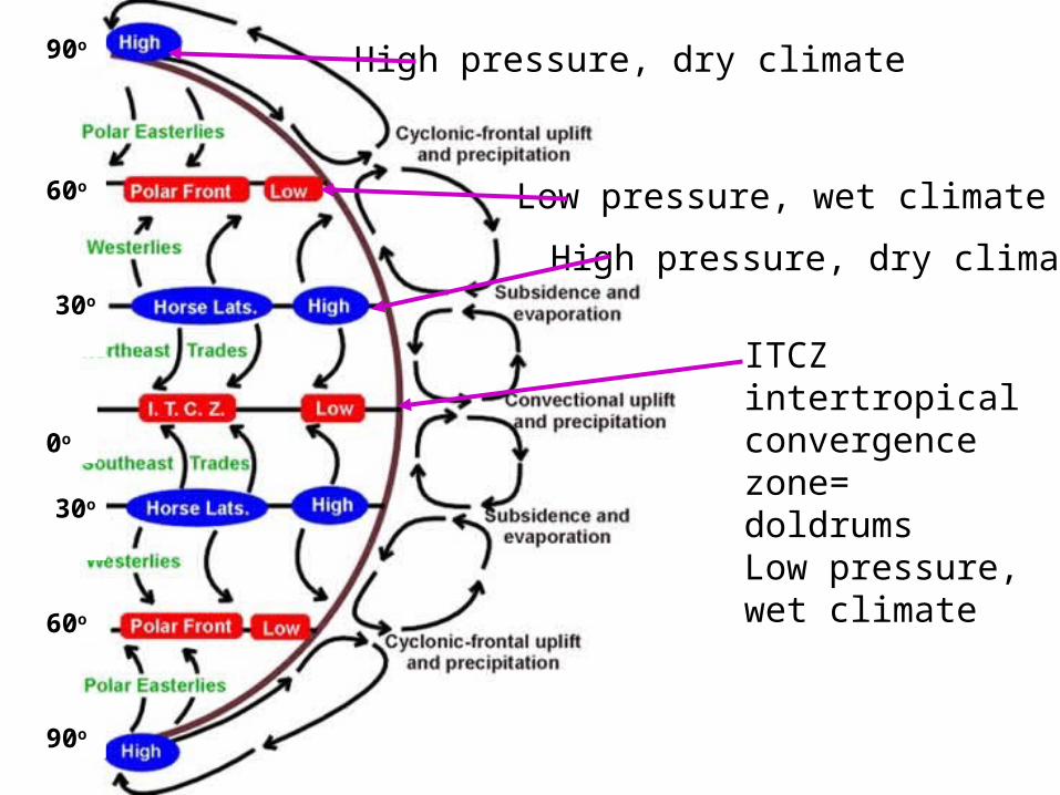
ITCZ intertropical convergence zone= doldrumsLow pressure, wet climate
High pressure, dry climate
Low pressure, wet climate
30o
30o
60o
60o
90o
90o
0o
High pressure, dry climate

A) Idealized winds generated by pressure gradient and Coriolis Force. B) Actual wind patterns owing to land mass distribution..

ITCZ

Seasonal changes in the position of the ITCZ
January

July

Winter monsoon-Dry
Summer monsoon-Wet

BiomeA major type of ecological community, determined largely by climate.
Forest
Tundra
Grassland
Desert
Tundra Chaparral
Tropical rainforest
Temperate Evergreen Forest
Temperate Deciduous Forest
Polar Ice
Grassland Taiga Desert Mountain Zones

Marine Biome
• Consists of oceans, coral reefs, and estuaries• The ocean is the largest of all ecosystems.• The ocean contains a diverse array of plants and
animals at various depth zones.• Coral reefs consist mainly of coral.• Estuaries are areas where fresh and salt water
environments converge. Mangroves, oysters, crabs and marsh grasses are examples of species in this environment.

Marine Biome

Hydrologic Cycle

Water Cycle in Hawaii

Rain shadow effect

The Coriolis effect• The Coriolis effect
– Is a result of Earth’s rotation– Causes moving objects to follow
curved paths:• In Northern Hemisphere, curvature
is to right• In Southern Hemisphere, curvature
is to left
– Changes with latitude:• No Coriolis effect at Equator• Maximum Coriolis effect at poles

The Coriolis effect on Earth
• As Earth rotates, different latitudes travel at different speeds
• The change in speed with latitude causes the Coriolis effect

equator
Quito
Buffalo
79oW
North Pole
South Pole
N
Quito
Buffalo
equa
tor
Buffalo moves 783 mphQuito moves 1036 mph
15o

• Gyres are large circular-moving loops of water• subtropical gyres
• Five main gyres (one in each ocean basin):• North Pacific• South Pacific• North Atlantic• South Atlantic• Indian
• Generally 4 currents in each gyre• Centered about 30o north or south
latitude
Current GyresCurrent Gyres
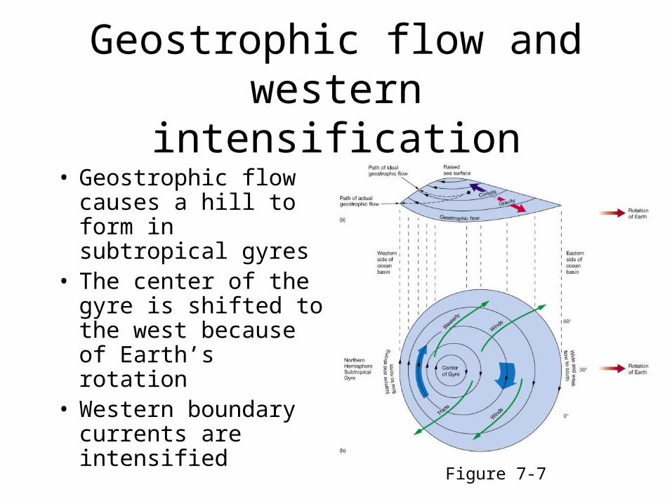
Geostrophic flow and western intensification
• Geostrophic flow causes a hill to form in subtropical gyres
• The center of the gyre is shifted to the west because of Earth’s rotation
• Western boundary currents are intensified
Figure 7-7

Western intensification of subtropical gyres
• The western boundary currents of all subtropical gyres are:– Fast– Narrow– Deep
• Western boundary currents are also warm• Eastern boundary currents of subtropical gyres
have opposite characteristics

Boundary Currents in the Northern Hemisphere
Type of Current General Features Speed Special Features
Western boundary Currents warm swift sharp boundary Gulf Stream, Kuroshio narrow w/coastal circulation,
deep little coastal upwelling
Eastern Boundary Currents cold slow diffuse boundariesCalifornia, Canary broad separating from coastal
shallow currents, coastal upwelling common


Wind-driven surface currents

Pacific Ocean surface currents
What do Nike, rubber What do Nike, rubber ducks, and hockey ducks, and hockey gloves have to do with gloves have to do with oceanography?oceanography?

2004-2007 Barber’s Point

Japan Tsunami 2011Prediction of Marine Debris Drifting Trajectories
Hawaii
http://www.hawaii247.com/2011/04/07/tsunami-2011-japan-debris-likely-to-hit-hawaii-twice/

Sea Surface Temperature

Origin and paths of tropical cyclones
• Tropical cyclones are intense low pressure storms created by:
– Warm water
– Moist air
– Coriolis effect

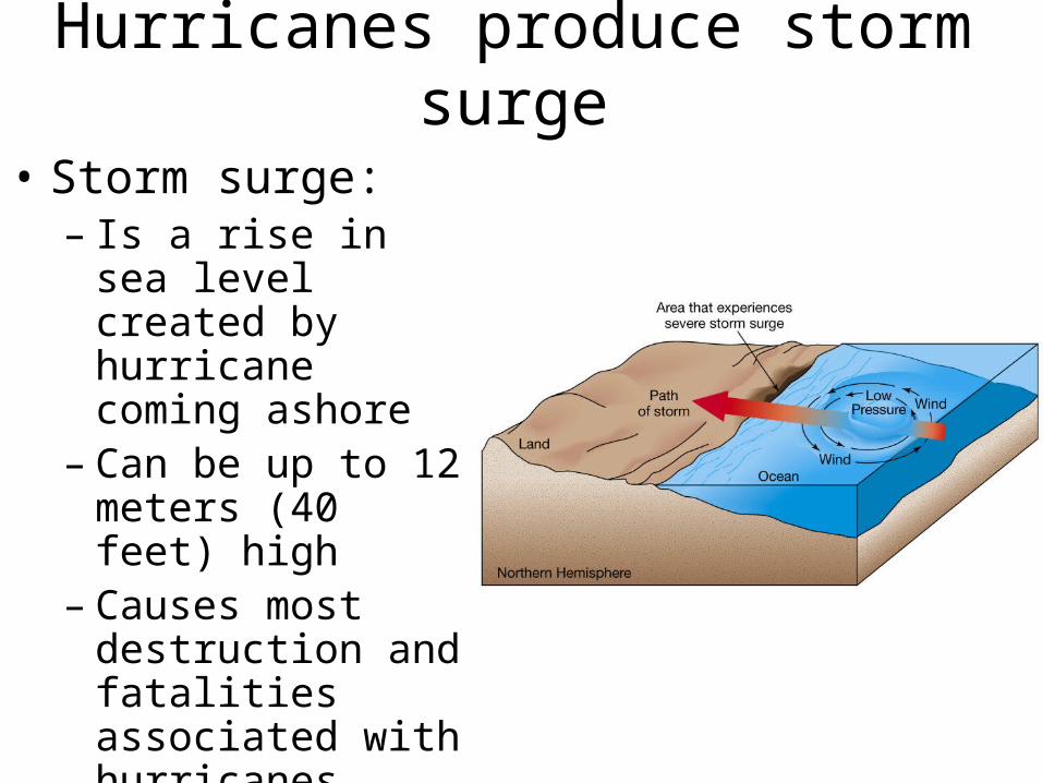
Hurricanes produce storm surge
• Storm surge:– Is a rise in sea level
created by hurricane coming ashore
– Can be up to 12 meters (40 feet) high
– Causes most destruction and fatalities associated with hurricanes

Dynamics of a Tropical Cyclone
Counter current circulation in Northern Hemisphere
L
Air moves toward zone of low pressure and veers off course to right

Hurricanes in Hawaii
Hurricane season- June 1 to November 30
Hurricanes approach from both east and south
Hawaii rarely gets hit
Hawaii is subtropical

Hurricane Path in Hawaii
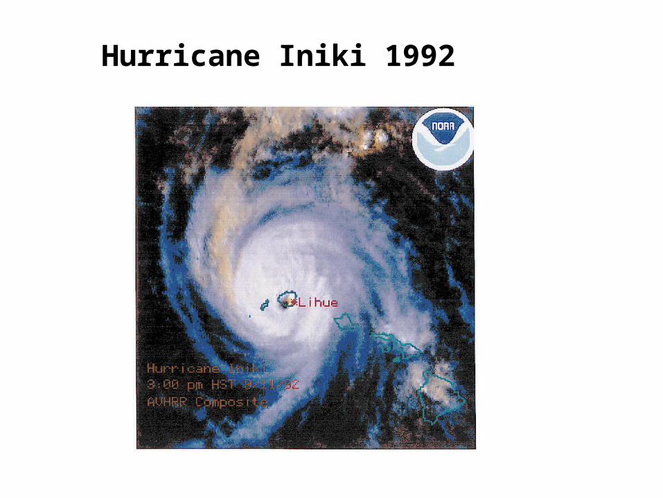
Hurricane Iniki 1992

Hurricane Daniel Aug 2000
Just missed us.

Hurricane Andrew

Eddy
Warm core ring1. Rotates clockwise2. Found on the landward side of the current
Cold core ring (cyclonic eddy)1. Rotates counterclockwise2. Forms on the ocean side of the current
A circular movement of water formed along the edge of a permanent current
In an average year, 10-15 rings are formed
150-300 km in diameter
Speed 1 m/sec
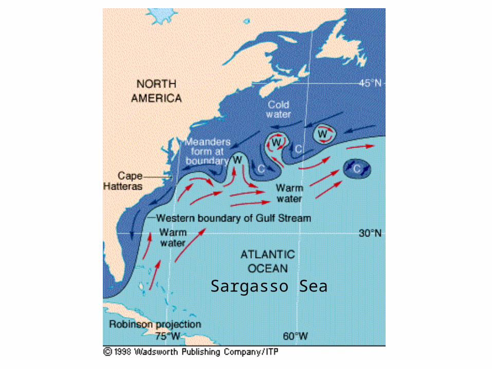
Sargasso Sea


Ekman spiral
• Ekman spiral describes the speed and direction of flow of surface waters at various depths
• Factors:– Wind– Coriolis effect
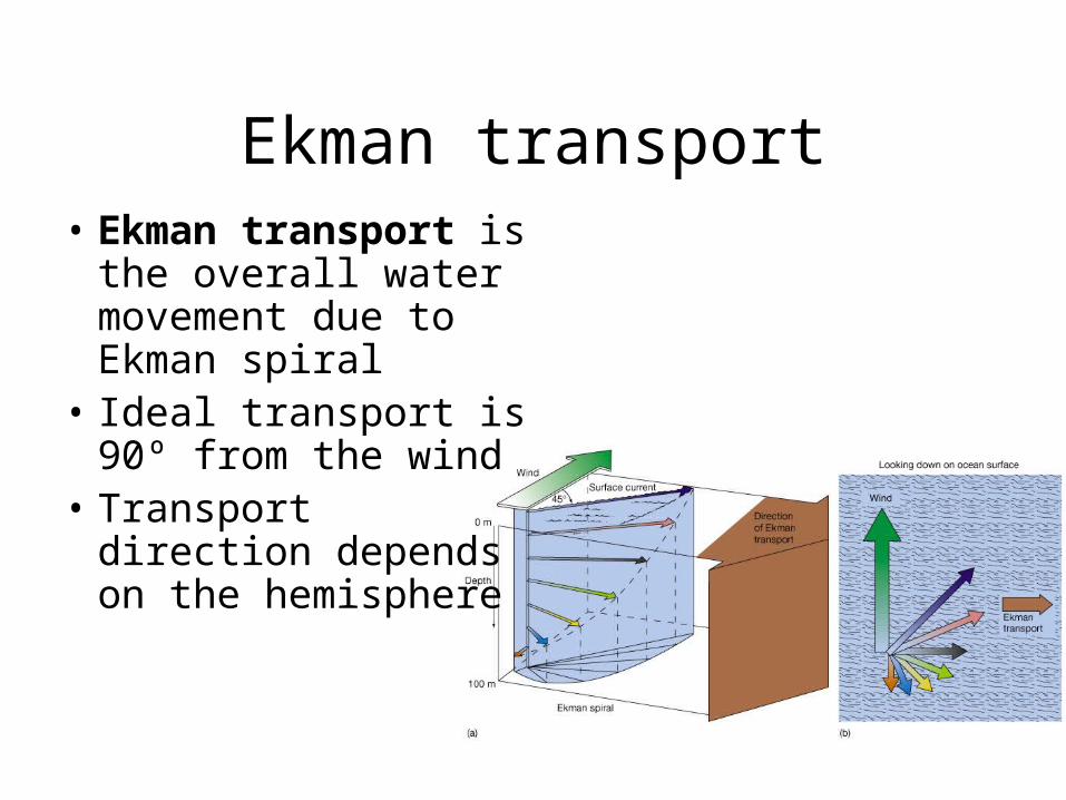
Ekman transport• Ekman transport is
the overall water movement due to Ekman spiral
• Ideal transport is 90º from the wind
• Transport direction depends on the hemisphere

Ekman Transport
Water flow in the Northern hemisphere- 90o to the right of the wind directionDepth is important

Upwelling and downwelling• Vertical movement of water ()
– Upwelling = movement of deep water to surface• Hoists cold, nutrient-rich water to surface• Produces high productivities and abundant marine life
– Downwelling = movement of surface water down• Moves warm, nutrient-depleted surface water down• Not associated with high productivities or abundant
marine life
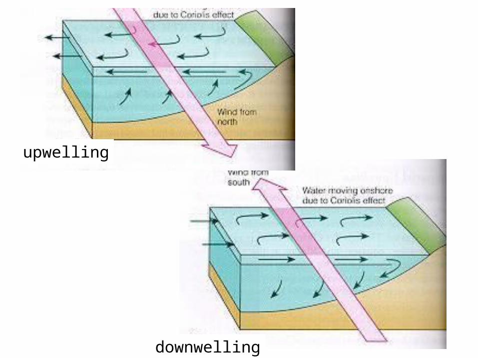
upwelling
downwelling

Langmuir Circulation

Global Warming

The E-M Spectrum

Fate of Solar Radiation Fate of Solar Radiation Reaching the EarthReaching the Earth
reflectionreflectioncloudsclouds
snow and icesnow and ice
the earth’s surfacethe earth’s surface
atmospheric dustatmospheric dust
reflectionreflectioncloudsclouds
snow and icesnow and ice
the earth’s surfacethe earth’s surface
atmospheric dustatmospheric dust

Fate of Solar Radiation Fate of Solar Radiation Reaching the EarthReaching the Earth
absorptionabsorptionatmosphereatmosphere
oceansoceans
landland
plant photosynthesisplant photosynthesis
absorptionabsorptionatmosphereatmosphere
oceansoceans
landland
plant photosynthesisplant photosynthesis

Fate of Solar Radiation Fate of Solar Radiation Reaching the EarthReaching the Earth
radiationradiationradiationradiation
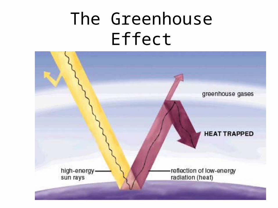
The Greenhouse Effect

Greenhouse GasesGreenhouse Gases
Carbon DioxideMethane
Nitrous OxideWater Vapor
Ozone

Thousands of Years Before Present
Tem
per
atu
re C
han
ge
(oF
)
Atm
osp
her
ic C
O2
(pp
m)

Year
Temperature
Carbon Dioxide
Tem
per
atu
re C
han
ge
(oF
)
Atm
osp
her
ic C
O2
(pp
m)
Atmospheric CO2 & Surface Temperature TrendsAtmospheric CO2 & Surface Temperature Trends

Sea level rise
Increased plant primary productivity
Shifts in the distribution of plants and animals
Water contamination and outbreaks of water-borne diseases
Increased storm severity
Potential melting or enlargement of polar ice caps
Changes to patterns of rainfall
More severe droughts or increased precipitation
changes to ocean circulation patterns
Predicted changes with increased greenhouse warming
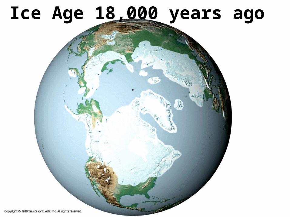
Ice Age 18,000 years ago

Sea Level Changes due to Ice Ages and Ice Cap Melting
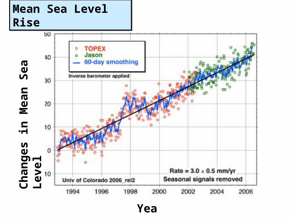
Year
Ch
ang
es in
Mea
n S
ea L
evel
Mean Sea Level RiseMean Sea Level Rise

Summer Arctic Sea Ice Decline Comparison between 1979 & 2005Summer Arctic Sea Ice Decline Comparison between 1979 & 2005

Year
Late Summer Arctic Sea Ice ExtentLate Summer Arctic Sea Ice Extent
Sea
Ice
Ext
ent
(mill
ion
km
2 )


Permafrost melting

Permafrost melting

Permafrost melting
Drunken forest

Year
North Atlantic Tropical Storms10-year running averageNorth Atlantic Tropical Storms10-year running average
Nam
ed T
rop
ical
Sto
rms

1 Meter Sea Level Rise Waikiki1 Meter Sea Level Rise Waikiki
http://www.soest.hawaii.edu/HMRG/FloodingOahu/index.phphttp://www.soest.hawaii.edu/coasts/sealevel/waikiki.html

Sea Level Rise
• Destroys coastal habitat (e.g. salt marshes, mangroves)
• Destroys human property• Increases pollution• Decreases freshwater supply

Effect on Marine Life• Phytoplankton bloom due to light and
temperature cues• Changes will impact food web• Hypoxia may result

Effect on Fisheries
• Migrations are in response to temperature• May impact fisheries

Effect on Corals• Coral bleaching • Leads to loss of habitat and food for reef-
dependent species

CurrentsOceanic conveyor belt may change ocean currents • Currents carry plankton• Bring food and oxygen• Distribute eggs and larvae• Remove wastes and pollutants

Salinity• Animals have a narrow range of tolerance• Glacial melting inputs lots of freshwater

Acidity• CO2 makes water acidic• Corals and other calcium carbonate species
can’t make skeleton• Impact on plankton development impacts food
web

Temperature• Higher temperature results in less O2
- Results in hypoxia• Ice melting leaves no resting/hunting areas for
polar bears• Antarctic Krill impacts food web

Invasive Species• Algae smothers coral• Invasive species out-compete natives

Weather Events
More severe weather patterns• El Niño• Hurricanes • Mudslides• Forest Fires• Drought

El Niño-Southern Oscillation (ENSO)
• El Niño = warm surface current in equatorial eastern Pacific that occurs periodically around Christmastime
• Southern Oscillation = change in atmospheric pressure over Pacific Ocean accompanying El Niño
• ENSO describes a combined oceanic-atmospheric disturbance

El Niño
• Oceanic and atmospheric phenomenon in the Pacific Ocean
• Occurs during December• 2 to 7 year cycle
Sea Surface Temperature
Atmospheric Winds
Upwelling

Normal conditions in the Pacific Ocean

El Niño conditions (ENSO warm phase)
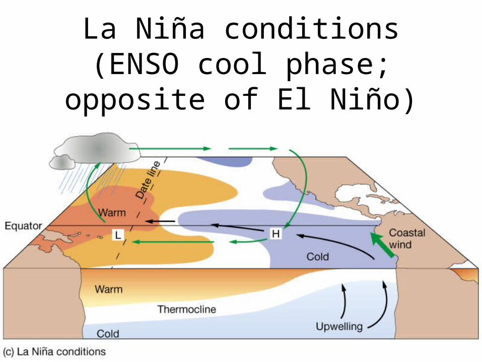
La Niña conditions (ENSO cool phase; opposite of El
Niño)

El NiñoNon El Niño
1997

Non El Niño
El Niño
thermocline
upwelling

El Niño events over the last 55 years
El Niño warmings (red) and La Niña coolings (blue) since 1950. Source: NOAA Climate Diagnostics Center

Effects of severe El Niños

1. What is a convection cell?2. What are current atmospheric CO2
levels?3. Why don’t we see many hurricanes in
Hawaii?4. What is the fate of the majority of solar
radiation that strikes the Earth?5. What is a drunken forest?6. Describe the rain shadow effect.7. How are biomes defined?
Inquiry